Application of tsunami modelling for escape and refuge planning in Aceh (Indonesia)
|
|
|
- Ambrose Neal
- 5 years ago
- Views:
Transcription
1 Application of tsunami modelling for escape and refuge planning in Aceh (Indonesia) Odelinde Nieuwenhuis, DHV BV Deepak Vatvani, Deltares (Delft Hydraulics) Jeroen Alberts, DHV BV Dick Jansen, DHV BV May 2008

2 Before tsunami After tsunami Tsunami 2004 event 9.2 MW extreme earthquake west of Sumatra, resulting in tsunami wave propagating in different directions Devastating effect on surrounding countries Pre-tsunami coastlin Pre tsunami coastline Vegetation and houses destructed Coastline erosion


3 Indonesia More than 160,000 people deceased or missing More than 500,000 people loosing houses/ livelihoods etc. Province of Aceh was hit the hardest Aceh
4 Presentation outline 1. Introduction SDC Project 2. Tsunami inundation modelling 3. Flood hazard mapping 4. Escape and refuge planning 5. Follow-up and conclusions
5 1. Introduction (1/11) 2. Tsunami inundation modelling 3. Flood hazard mapping 4. Escape and refuge planning 5. Follow-up and conclusions SDC Project Sea Defence, Flood Protection, Refuge and Early Warning System Project (SDC Project) Dutch/ Indonesian consortium lead by DHV Group (other Dutch partners: Witteveen + Bos, Deltares) Primary development objectives: -put in place an appropriate strategy for sea defence, flood protection, multifunctional refuge facilities and a regional early warning system -provide design guidelines for such systems Important consideration: resettlement in high risk coastal areas!
6 1. Introduction (2/11) 2. Tsunami inundation modelling 3. Flood hazard mapping 4. Escape and refuge planning 5. Follow-up and conclusions Focus of presentation SDC s objectives require more insight in flood risk: Set up of tsunami inundation models and creation of flood hazard maps Various uses of flood hazard maps in SDC project: Spatial planning purposes (focus on saving lives; escape and refuge planning) Warning system (database of hazard maps) Detailed damage and risk assessment Assessment effectiveness and cost benefit analysis tsunami protection measures Increased understanding propagation tsunami wave and resulting coastal flooding
7 1. Introduction (2/11) 2. Tsunami inundation modelling 3. Flood hazard mapping 4. Escape and refuge planning 5. Follow-up and conclusions Focus of presentation SDC s objectives require more insight in flood risk: Set up of tsunami inundation models and creation of flood hazard maps resentation Various uses of flood hazard maps in SDC project: Spatial planning purposes (focus on saving lives; escape and refuge planning) Warning system (database of hazard maps) Detailed damage & casualties + risk assessment Assessment effectiveness and cost benefit analysis tsunami protection measures Understanding propagation tsunami wave and resulting coastal flooding


8 1. Introduction 2. Tsunami inundation modelling (3/11) 3. Flood hazard mapping 4. Escape and refuge planning 5. Follow-up and conclusions Tsunami inundation modelling Initial tsunami wave field (a. fault modelling for different earthquake scenarios or b. data for actual event) Hydrodynamic tsunami model then computes: -propagation through ocean -resulting flooding when reaching coastal areas Jakart a
9 1. Introduction 2. Tsunami inundation modelling (4/11) 3. Flood hazard mapping 4. Escape and refuge planning 5. Follow-up and conclusions SDC inundation models Existing tsunami inundation models (Delft3D software, set up by project partner Deltares) showed: good simulation of overall tsunami inundation patterns improvement required for detailed patterns Existing models were refined (grid resolution, more detailed bathymetry and topography data) Resulting in new set of SDC inundation models: -1 overall propagation model, 1000 m resolution -5 regional flooding models, 200 m resolution -1 detailed flooding model case study area Banda Aceh, 50 m resolution

10 Overall propagation model


11 Regional models and case study area Banda Aceh


12 Detailed flood model case study area Banda Aceh
13 1. Project background 2. Tsunami inundation modelling (5/11) 3. Flood hazard mapping 4. Escape and refuge planning 5. Follow-up and conclusions Validation model results Validation only possible for December 2004 event: Wave heights at sea, these were validated and found to be accurately simulated for existing models by Deltares (Vatvani, 2005) Inundation patterns and depths were analysed based on satellite pictures (presence vegetation), eyewitness reports and measured values by survey teams. Computated inundation with refined models turned out to agree very well with actual inundation, patterns as well as depth.


14 Validation of inundation patterns Banda Aceh Satellite imagery (December 30th 2004) Computed inundation Conclusion: new set of models provide a tool that is reliable and suitable for SDC s project objectives
15 1. Project background 2. Tsunami inundation modelling 3. Flood hazard mapping (6/11) 4. Escape and refuge planning 5. Follow-up and conclusions Probability of occurence Data over sufficiently long period is not available Based on other studies and analyses, an estimate was set up of probability of occurence for earthquake scenarios Magnitude (Mw) Anywhere along fault line At one specific spot years 100 years 8 75 years 150 years years 200 years years 500 years years 1000 years Probability of event similar December 2004 to occur anywhere along Sunda fault line is in the range of 1/300 to 1/500 years
16 1. Project background 2. Tsunami inundation modelling 3. Flood hazard mapping (7/11) 4. Escape and refuge planning 5. Follow-up and conclusions Flood hazard maps Over 300 computations executed up to now for creation of database flood hazard maps (for different earthquake scenarios; varying location, strength, focal depth, dip angle) Initial design condition for escape and refuge planning: December 2004 event flood hazard map


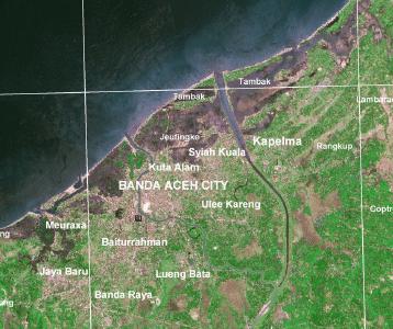
17 Flood hazard map Banda Aceh (December 2004 event) Case study area: Kec. Syah Kuala
18 1. Project background 2. Tsunami inundation modelling 3. Flood hazard mapping 4. Escape and refuge planning (8/11) 5. Follow-up and conclusions Zoning plan Based on the flood hazard map and inundation depths, impact areas are defined for planning purposes: Direct impact zone; survival rate minimum, only specifically designed buildings will remain standing Evacuation zone; evacuation required, only solid engineered structures will remain standing Wet feet zone; debris remains a threat to human lives, most normal structures will remain standing Safe zone; no impact

19 Zoning plan case study area Banda Aceh
20 1. Project background 2. Tsunami inundation modelling 3. Flood hazard mapping 4. Escape and refuge planning (9/11) 5. Follow-up and conclusions Escape and refuge plans Based on the zoning plan and spatial data (population figures, road maps, inventory of buildings), more detailed escape and refuge plans are set up: Escape capacity plan Refuge facility plan Escape route plan Warning plan Note: People are resettling in high risk areas in Banda Aceh, where fatality rates are expected to be 60-70%. Escape and refuge plans very important and therefore have been set up for all high risk areas.


21 Escape and refuge plans case study area Banda Aceh
22 1. Project background 2. Tsunami inundation modelling 3. Flood hazard mapping 4. Escape and refuge planning 5. Follow-up and conclusions (10/11) Follow-up Sumatra Collaboration has been set up with universities Sumatra; training and support in further development of model. First target: expanding tsunami model for entire high risk area Sumatra west coast (completion in 2009). Possible follow up: set up of escape and refuge plans for these areas.
23 1. Project background 2. Tsunami inundation modelling 3. Flood hazard mapping 4. Escape and refuge planning 5. Follow-up and conclusions (11/11) General conclusions The SDC tsunami inundation models has proven to be a reliable tool and suitable for detailed risk assessment and spatial planning purposes. A general stepwise methodology translating flood hazard maps to detailed escape and refuge plans has been set up and can be used in other areas. Similar regional tsunami inundation models and the presented stepwise methodology can be applied in other countries surrounding the Indian Ocean.
24 Thank you for your attention Questions?
FLOOD HAZARD AREA LAND USE MANAGEMENT
 FLOOD HAZARD AREA LAND USE MANAGEMENT Introduction Guidance For Selection of Qualified Professionals and Preparation of Flood Hazard Assessment Reports This document is intended to provide guidance for
Flood Hazard Area Land Use Management Guidelines Sea Level Rise Amendment. Effective January 1, 2018
 Flood Hazard Area Land Use Management Guidelines Sea Level Rise Amendment Effective January 1, 2018 What are the Flood Hazard Area Land Use Guidelines used for again? Flood Hazard Area Land Use Management
RECONSTRUCTION OF LAND ADMINISTRATION SYSTEM IN NANGGROE ACEH DARUSSALAM (NAD) AND NIAS
 AND NIAS") RECONSTRUCTION OF LAND ADMINISTRATION SYSTEM IN NANGGROE ACEH DARUSSALAM (NAD) AND NIAS Joyo WINOTO, Indonesia Key words: Tsunami; Land Administration; Land Rights Protection; Community Driven Adjudication
RECONSTRUCTION OF LAND ADMINISTRATION SYSTEM IN NANGGROE ACEH DARUSSALAM (NAD) AND NIAS Joyo WINOTO, Indonesia Key words: Tsunami; Land Administration; Land Rights Protection; Community Driven Adjudication
Welcome at the First International Symposium on Geo-information for Disaster Management (Gi4DM)
") Welcome at the First International Symposium on Geo-information for Disaster Management (Gi4DM) by prof. Jacob Fokkema, Rector of the Delft University of Technology April 25, 2005 1 Vermelding onderdeel
Welcome at the First International Symposium on Geo-information for Disaster Management (Gi4DM) by prof. Jacob Fokkema, Rector of the Delft University of Technology April 25, 2005 1 Vermelding onderdeel
Preparing for a Cascadia Subduction Zone Tsunami: A Land Use Guide for Oregon Coastal Communities
 Prepared by The Department of Land Conservation and Development April 2015 Preparing for a Cascadia Subduction Zone Tsunami: A Land Use Guide for Oregon Coastal Communities Acknowledgements Technical Advisory
Qualified Professionals, Land Owners and Developers. FROM: Development Services. DATE: November 29, 2017
 TO: Qualified Professionals, Land Owners and Developers FROM: Development Services DATE: November 29, 2017 RE: Terms of reference for Natural Hazard and/or Risk Assessments The District of Squamish (District)
DISTRICT OF NORTH SAANICH B Y L A W N O A BYLAW TO MITIGATE COASTAL FLOODING HAZARDS
 DISTRICT OF NORTH SAANICH B Y L A W N O. 1439 A BYLAW TO MITIGATE COASTAL FLOODING HAZARDS WHEREAS: A. If a flood plain has been designated in a District bylaw, the Local Government Act requires that the
River Road - Civil Design Report. Appendix D. Flood Hazard Map. Beca //04 August // NZ // page 38
 River Road - Civil Design Report Appendix D Flood Hazard Map Beca //04 August 2016 3124460 // NZ1-12891696-39 0.39 // page 38 Regional scale flood hazard mapping Waikato Regional Council holds regional
Geo-information for Disaster Management: 9/11 Lessons & Developments Since
 Geo-information for Disaster Management: 9/11 Lessons & Developments Since Michael J. Kevany Senior Vice President PlanGraphics, Inc. mkevany@plangraphics.com Introduction World Trade Center perspective
Some Social and Policy Implications of Shore Erosion. James G. Titus U.S. Environmental Protection Agency
 Some Social and Policy Implications of Shore Erosion James G. Titus U.S. Environmental Protection Agency Four copyrighted photos included in briefing as fair use Deleted because duplication may violate
Updated - A Report on the County of Arlington s Existing and Possible Urban Tree Canopy
 Updated - A Report on the County of Arlington s Existing and Possible Urban Tree Canopy Key Terms UTC: Urban tree canopy (UTC) is the layer of leaves, branches, and stems of trees that cover the ground
The Added Value of Geospatial Information in Disaster and Risk Management: A Case Study on the 2009 Flooding in Namibia
 The Added Value of Geospatial Information in Disaster and Risk Management: A Case Study on the 2009 Flooding in Namibia Summary Tessa Anne Belinfante, M.Sc. VU University Amsterdam Objective and Approach
Task 3. Contributing to European Flood Hazard Atlas. Task Review Grenoble. February February 2008
 Task 3 Contributing to European Flood Hazard Atlas Task Review Grenoble February 2008 February 2008 Objectives To develop and test a general procedure for building a European Flood Hazard Atlas based upon
IUTC - UNHABITAT. Land Readjustment as Tools for Urban Regeneration. Case Study Indonesia : Banda Aceh, Jakarta, Surabaya
 IUTC - UNHABITAT Land Readjustment as Tools for Urban Regeneration Case Study Indonesia : Banda Aceh, Jakarta, Surabaya elevation of 0.80 meters above sea level. The city regency covers an area of 64
Volume Three Appendix 7. Scheme Plan and other subdivision requirements
 Volume Three Appendix 7 Appendix 7 Scheme Plan and other subdivision requirements Any application for subdivision consent must be accompanied by a Scheme Plan that contains the information set out in this
Cadastral Reconstruction in Aceh: A Newborn Concept of Adjudication 1
 1 Tony S. HAROEN, Chairul B. ACHMAD and Wenny RUSMAWAR, National Land Agency / Badan Pertanahan SUMMARY Tsunami and earthquake in 26 th December 2004 in Aceh, the northern part of Sumatra Island, have
The Readiness of the Trinidad and Tobago Cadastral System for Recovery from Disaster
 Presented at the FIG Working Week 2016, May 2-6, 2016 in Christchurch, New Zealand The Readiness of the Trinidad and Tobago Cadastral System for Recovery from Disaster Charisse GRIFFITH-CHARLES Trinidad
ERRA S RURAL LANDLESS PROGRAMME (PHASE - II FOR VIRTUALLY LANDLESS PEOPLE)
") ERRA S RURAL LANDLESS PROGRAMME (PHASE - II FOR VIRTUALLY LANDLESS PEOPLE) Introduction Earthquake Reconstruction & Rehabilitation Authority s Policy for virtually landless people is an extension of the
ERRA S RURAL LANDLESS PROGRAMME (PHASE - II FOR VIRTUALLY LANDLESS PEOPLE) Introduction Earthquake Reconstruction & Rehabilitation Authority s Policy for virtually landless people is an extension of the
Towards Seismic Hazard
 Towards Seismic Hazard Curves Collaboration with; UoM, UniCT, INGV P.O Italia-Malta 2007-2013 progetto SIMIT (Codice B1-2.19/11): P.O Italia-Malta 2007-2013 progetto SIMIT (Codice B1-2.19/11): Earthquake
INDIAN INSTITUTE OF TECHNOLOGY ROORKEE. Presentation on REAL TIME CADASTRAL SURVEYING SOLUTION WITH A SPECIAL IMPHESIS TO MODERN GPS TECHNOLOGY.
 INDIAN INSTITUTE OF TECHNOLOGY ROORKEE Presentation on REAL TIME CADASTRAL SURVEYING SOLUTION WITH A SPECIAL IMPHESIS TO MODERN GPS TECHNOLOGY By: Prof. Kamal Jain, Dept. of Civil Engg. IIT-Roorkee AIM
A View Like Never Before
 A View Like Never Before Introducing CoStar Multifamily Whether you buy, sell, develop, underwrite or value multifamily properties, or advise industry professionals, you need granular multifamily property
Alberta Flood Hazard Identification Program
 Alberta Flood Hazard Identification Program Peter Onyshko, P.Eng., CFM River Forecast Section Alberta Environment and Parks November 5, 2015 Flood Hazard Identification Program Presentation Outline Introduction
FLOODrisk rd European Conference on Flood Risk Management
 Possibilities of neighborhood evacuation within a district in the event of a large-scale flood in a low-lying area: A case study of Shinden district in Tokyo Hitoshi Nakamura 1,a 1 Shibaura Institute of
3.11 East Japan Earthquake and Topics related to Land management. Masaru Kaidzu Ibaraki-ken EX-JICA Expert Association
 3.11 East Japan Earthquake and Topics related to Land management Masaru Kaidzu Ibaraki-ken EX-JICA Expert Association The 2011 off the Pacific coast of Tohoku Earthquake Date-Time: March 11, 2011 14:46
A Geocoded Cadastral Fabric as a Precondition for a Sustainable Land Management System
 A Geocoded Fabric as a Precondition for a Sustainable Land Management System Gottfried KONECNY, Germany; J.P. LAUZON, Canada; Abdul Salam MOHAMMED, India Key words: SDI,, Parcel Boundaries, GPS-GNSS, Land
PROPOSED FINDINGS OF FACT BENDER URBAN GROWTH BOUNDARY EXPANSION AND ANNEXATION REQUEST April 3, Background
 PROPOSED FINDINGS OF FACT BENDER URBAN GROWTH BOUNDARY EXPANSION AND ANNEXATION REQUEST April 3, 2016 Background The owners of TL300, 301, 302, 303, and 304, 3N1027BD - properties abutting the City Limits
Criteria for Appeals of Flood Insurance Rate Maps. November 30, 201 1
 Criteria for Appeals of Flood Insurance Rate Maps November 30, 201 1 This document outlines the criteria for appealing proposed changes in flood hazard information on Flood Insurance Rate Maps (FIRMS)
Overview of Federal and State Floodplain Management Programs
 Overview of Federal and State Floodplain Management Programs Peter DeMeo, PE Supervising Environmental Engineer New Jersey Department of Environmental Protection Division of Land Use Regulation October
Copernicus Land Monitoring Service (Pan- European and Local) in the Netherlands
 in the Netherlands") Copernicus Land Monitoring Service (Pan- European and Local) in the Netherlands Wageningen Environmental Research (WENR) activiteiten 13 Juni 2018, Gerard Hazeu Introduction Personal note and some terminology
Copernicus Land Monitoring Service (Pan- European and Local) in the Netherlands Wageningen Environmental Research (WENR) activiteiten 13 Juni 2018, Gerard Hazeu Introduction Personal note and some terminology
Keith Clifford Bell EASER. December 15, 2010 pm MC2-800 ; 12:30-2:30
 Keith Clifford Bell EASER December 15, 2010 pm MC2-800 ; 12:30-2:30 The context and challenges. Interventions in Aceh land sector. RALAS. Study Gender Impacts of Land Titling in Aceh. Considerations for
Support to Implementation of Multipurpose Cadastral Information system in Vietnam
 Support to Implementation of Multipurpose Cadastral Information system in Vietnam Lennart JOHANSSON and Per SÖRBOM, Sweden Key words: Land Registration, Land Information, Land Administration, SWOT analyse,
River outlook development project
 Property Information 3 2 Legal Description 30 Long St Lot 2 DP 14660 Certificate of Title CB527/52 45 Bamford St PT Lot 3 DP 25349 Certificate of Title CB6D/1335 49 Bamford St Lot 1 DP 24660 Certificate
GI support for land consolidation
 Problems GI support for land consolidation Bela MARKUS University of West Hungary College of Geoinformatics Technology??? Legislation Organization Financial Awareness Ill-structured process 2 Past Present
Learning from land suitability analysis and Dutch spatial policy for sustainable land use in Japan
 Learning from land suitability analysis and Dutch spatial policy for sustainable land use in Japan Toru Nagayama 22 January 2009 GIS Research Group Seminar, University of Tsukuba Highlights from : Nagayama.,
REGIONAL DISTRICT OF NANAIMO BYLAW NO. 1469
 REGIONAL DISTRICT OF NANAIMO BYLAW NO. 1469 A BYLAW TO ESTABLISH FLOODPLAINS, CONSTRUCTION LEVELS IN FLOODPLAINS, AND SETBACKS FOR LANDFILL AND STRUCTURES IN FLOODPLAINS WHEREAS Section 910 of the Local
FLOOD HAZARD AREA LAND USE MANAGEMENT GUIDELINES. May Ministry of Water, Land and Air Protection. Province of British Columbia
 FLOOD HAZARD AREA LAND USE MANAGEMENT GUIDELINES May 2004 Ministry of Water, Land and Air Protection Province of British Columbia Amended by: Ministry of Forests, Lands, Natural Resource Operations and
CPPDSM4003A Appraise property
 CPPDSM4003A Appraise property Unit descriptor Employability skills Prerequisite units Application of the unit Competency field Unit sector This unit of competency specifies the outcomes required to appraise
Crediting Conservation: Frequently Asked Questions
 Crediting Conservation: Frequently Asked Questions 1) How and who developed the Conservation Plus family of land use scenarios, also known as Land Policy Best Management Practices (BMPs)? The Conservation
Tidal Datum Consistency for Marine Cadastre Littoral Zone Commencement in Malaysia
 Tidal Datum Consistency for Marine Cadastre Littoral Zone Commencement in Malaysia Rasheila Rahibulsadri, Abdullah Hisam Omar, Ashraf Abdullah, Wan Muhammad Aizzat Wan Azhar, Chan Keat Lim, Teng Chee Hua,
Designing for transparency and participation in the Hellenic Cadastral Project
 Designing for transparency and participation in the Hellenic Cadastral Project Dr. Dimitris Rokos Director of Planning and Investments, Hellenic National Cadastre and Mapping Agency S.A. Table of Contents
SECTION 10: FLOOD HAZARD EVALUATION 10-1
 10) SECTION 10: FLOOD HAZARD EVALUATION A. General. Land subject to being flooded by a Flood of 100-Year Frequency as defined by Title 76, Chapter 5, MCA, or land subject to flooding pursuant to these
LAND ISSUES AND GEO-INFORMATION: RESPONDING POST DISASTER EARTHQUAKES IN NEPAL
 LAND ISSUES AND GEO-INFORMATION: RESPONDING POST DISASTER EARTHQUAKES IN NEPAL ARBIND MAN TULADHAR FACULTY OF GEO-INFORMATION SCIENCE AND EARTH OBSERVATION (ITC), UNIVERSITY OF TWENTE, THE NETHERLANDS,
Spatially Enabled Society Role of the Cadastre
 armasuisse Bundesamt für Landestopografie swisstopo Swiss Federal Directorate for Cadastral Surveying Spatially Enabled Society Role of the Cadastre XXIV FIG International Congress 2010 FIG-Task Force
Floodplain Development Land Use Review
 PUBLIC WORKS - COMMUNITY DEVELOPMENT 333 Broadalbin Street SW, PO Box 490, Albany, Oregon 97321-0144 BUILDING 541-917-7553 PLANNING 541-917-7550 Floodplain Development Land Use Review Application Information
FUTURE LAND USE. City of St. Augustine Comprehensive Plan EAR-Based Amendments
 FUTURE LAND USE City of St. Augustine Comprehensive Plan EAR-Based Amendments Future Land Use Element FLU Goal To create an environment within the City and adjacent areas in which its residents have the
SC Dams and Reservoirs Safety
 SC Dams and Reservoirs Safety Inspection of Embankment Dams John A. Poole, P.E. SCDHEC Topics Covered History of the Dam Safety Program: Time line of the program and important events Inspections Performed
HIGH-RISE BUILDING INVENTORY FORMS (B.I.F.) PRODUCTION AND APPROVAL
 PRODUCTION AND APPROVAL") HIGH-RISE BUILDING INVENTORY FORMS (B.I.F.) PRODUCTION AND APPROVAL Only a person authorized by the Los Angeles Fire Department shall approve High-rise Building Inventory Forms. All individuals authorized
HIGH-RISE BUILDING INVENTORY FORMS (B.I.F.) PRODUCTION AND APPROVAL Only a person authorized by the Los Angeles Fire Department shall approve High-rise Building Inventory Forms. All individuals authorized
Surabaya River Improvement Project (II-1)
") Indonesia 1. Project Profile and Japan s ODA Loan (1) Background Surabaya River Improvement Project (II1) Report Date: June 2 Field Survey: February 2 When this project was planned in 199, the city of
Indonesia 1. Project Profile and Japan s ODA Loan (1) Background Surabaya River Improvement Project (II1) Report Date: June 2 Field Survey: February 2 When this project was planned in 199, the city of
R E Q U E S T F O R P R O P O S A L S
 P.O. Box 3209, Houghton, 2041 Block A, Riviera Office Park, 6-10 Riviera Road, Riviera R E Q U E S T F O R P R O P O S A L S M A R K E T S U R V E Y T O I N F O R M R E S I D E N T I A L H O U S I N G
Course Number Course Title Course Description
 Johns Hopkins Carey Business School Edward St. John Real Estate Program Master of Science in Real Estate and Course Descriptions AY 2015-2016 Course Number Course Title Course Description BU.120.601 (Carey
RWANDA NATURAL RESOURCES AUTHORITY Department of Lands and Mapping
 RWANDA NATURAL RESOURCES AUTHORITY Department of Lands and Mapping National Land Use and Development Master Plan Presentation to National Forum on Sustainable Urbanisation in Support of EDPRS 2 Eng. Didier
PURPOSE OF STUDY. physical and social environments, as well as our political and economic institutions. As a commodity,
 PURPOSE OF STUDY Housing is one of the most important elements in our lives and our communities. Providing shelter and links to neighborhoods and larger communities, housing plays an essential part in
RevuPro Appraisal Review
 RevuPro Appraisal Review Getting It Right ELLIOTT introduces its flagship review product RevuPro, as an independent appraisal review service. Q. What is it and what does it do? A. RevuPro is a fast, economical
Spreading Awareness Through HAZUS - Outreach Efforts in New London, CT
 Spreading Awareness Through HAZUS - Outreach Efforts in New London, CT Amol Daxikar, GISP, CFM & Erin Howell, GISP, CFM Thursday, June 13, 2013 Agenda Introduction Project Location Prescoping and Initial
BASICS OF FLOODPLAIN MANAGEMENT & PLANNING IN NEW JERSEY
 BASICS OF FLOODPLAIN MANAGEMENT & PLANNING IN NEW JERSEY STATE OF NEW JERSEY DEPARTMENT OF ENVIRONMENTAL PROTECTION VINCENT J. MAZZEI, JR., PE November 12, 2008 Flood Hazard Areas What is a 100-year flood?
City of Bellingham Redevelopment Incentive Recommendations at a Glance
 City of Bellingham Redevelopment Incentive Recommendations at a Glance TARGETED DEVELOPMENT FORMS AND CITY WIDE ECONOMIC INCENTIVES KEY X Currently applicable Y Recommended TBD Further discussion or information
PROPERTY INTERNATIONAL LTD DREAM TO REALITY
 PROPERTY INTERNATIONAL LTD DREAM TO REALITY ABOUT US Property International Ltd (PIL) is a full service town master planning, land and property development and advisory firm based in Dar es Salaam, Tanzania,
The Promised Land in Sight Preliminary Issuance on a LAMP Study
 The Promised Land in Sight Preliminary Issuance on a LAMP Study Agenda Project Location: more levees than we can count! LLPT meetings Results Bottom Line Project Location 3 The Promised Land in Sight Preliminary
Question 7: Titles in and adjacent to the marine and coastal area
 19 October 2010 Māori Affairs Committee Marine and Coastal Area (Takutai Moana) Bill Question 7: Titles in and adjacent to the marine and coastal area On 13 October, the Committee asked for: Advice on
IRS FORM 8283 SUPPLEMENTAL STATEMENT DONATION OF CONSERVATION EASEMENT
 Name(s) shown on income tax return Identifying Number Robert T. Landowner 021-34-1234 Susan B. Landowner 083-23-5555 IRS FORM 8283 SUPPLEMENTAL STATEMENT DONATION OF CONSERVATION EASEMENT On November 12,
Chapter 5. Floodplain Management. 5.0 Introduction. 5.1 Douglas County Comprehensive Master Plan. 5.2 Floodplain Management and Regulation
 5.0 Introduction This chapter summarizes the County s rules and regulations regarding floodplain management and development. The requirements presented in this chapter should be used by the design engineer
Notes on the 1906 Aerial Panorama of San Francisco by George Lawrence
 Notes on the 1906 Aerial Panorama of San Francisco by George Lawrence Peter Nurkse nurkse@gmail.com You can see many brand new buildings in this picture, even though it was taken only six weeks after the
Shelter. International Recovery Platform (IRP) & Y. Shiozaki, Y. Tanaka, and A. Hokugo (Kobe University)
 & Y. Shiozaki, Y. Tanaka, and A. Hokugo (Kobe University)") Shelter International Recovery Platform (IRP) & Y. Shiozaki, Y. Tanaka, and A. Hokugo (Kobe University) 1 Flow of Housing Recovery Process Disaster Evacuation Shelter Usually municipal buildings, schools,
Shelter International Recovery Platform (IRP) & Y. Shiozaki, Y. Tanaka, and A. Hokugo (Kobe University) 1 Flow of Housing Recovery Process Disaster Evacuation Shelter Usually municipal buildings, schools,
Copernicus Sentinels the game changer?
 Setting the workshop scene OTSC-data in IACS and its Copernicus alternatives Philippe Loudjani, Wim Devos, Pavel Milenov, Guido Lemoine, Csaba Wirnhardt, Pär Åstrand JRC D5 MARS CAPland Inter-service brainstorming
Streamlined Annual PHA Plan (HCV Only PHAs)
") Streamlined Annual PHA Plan (HCV Only PHAs) U.S. Department of Housing and Urban Development Office of Public and Indian Housing OMB No. 2577-0226 Expires 02/29/2016 A. PHA Information. PHA Name: City
Streamlined Annual PHA Plan (HCV Only PHAs) U.S. Department of Housing and Urban Development Office of Public and Indian Housing OMB No. 2577-0226 Expires 02/29/2016 A. PHA Information. PHA Name: City
GOVERNMENT CODE SECTION GOVERNMENT CODE SECTION 65302
 GOVERNMENT CODE SECTION 65300 65300. Each planning agency shall prepare and the legislative body of each county and city shall adopt a comprehensive, long-term general plan for the physical development
The computerised land reallotment process in Turkey and the Netherlands in multi-purpose land consolidation projects
 The computerised land reallotment process in Turkey and the Netherlands in multi-purpose land consolidation projects FIG Conference, 15 April 2010, Sydney Louisa J. M. Jansen (Netherlands), Mustafa Karatas,
The Danish Digital Cadastral Map A Tool for Land Management
 The Danish Digital Cadastral Map A Tool for Land Management Søren CHRISTENSEN, Denmark Key words: Digital cadastre, restrictions pertaining to public law, land management. ABSTRACT The establishments of
Guidance on Public Rights of Way Affected by Coastal and Estuarine Change or Management
 Guidance on Public Rights of Way Affected by Coastal and Estuarine Change or Management The purpose of this guidance: To ensure public rights of way issues are properly addressed in any coastal (including
Owners and Investors
 Owners and Investors Confident real estate investing starts with knowing everything. See the commercial real estate market top down and ground up. You have the money, but how do you know where to invest
Community & Infrastructure Services Committee
 REPORT TO: DATE OF MEETING: September 12, 2016 Community & Infrastructure Services Committee SUBMITTED BY: Alain Pinard, Director of Planning, 519-741-2200 ext. 7319 PREPARED BY: Natalie Goss, Senior Planner,
The Strategic Plan can be viewed by clicking this link.
 What is the purpose of the Land Information Office? Many of Brown County's most basic services rely on accurate and up-to-date land information. Emergency response, resource conservation, infrastructure
Addressing Land Sector Opportunities with Geospatial Information in Nepal
 The 20th UNRCC-AP and the 4th UN-GGIM-AP 5-10 October 2015 Jeju Island, Republic of Korea Addressing Land Sector Opportunities with Geospatial Information in Nepal Krishna Raj BC Executive Director Land
ESCAPE ROUTES DESIGN SPECIFICATION ANALYSIS FOR OPTIMUM EVACUATION OF 200 PEOPLE IN HIGH-RISE BUILDING
 Jurnal Alam Bina, Jilid 13: No.4, 2008. ESCAPE ROUTES DESIGN SPECIFICATION ANALYSIS FOR OPTIMUM EVACUATION OF 200 PEOPLE IN HIGH-RISE BUILDING Yahya Mohamad Yatim Department of Quantity Survey, Faculty
APPENDIX B COMPLIANCE WITH THE GOVERNMENT CODE
 APPENDIX B COMPLIANCE WITH THE GOVERNMENT CODE A. GENERAL PLAN AMENDMENT PROCEDURE In general, local governments may not amend any of the mandatory elements of the General Plan (e.g. Land Use, Open Space,
Flood Hazard Area Control Act Rules
 An Overview of New Jersey s Flood Hazard Area Control Act Rules State of New Jersey Department of Environmental Protection Chingwah Liang Why Regulate NJ s Floodplains? 1. New Jersey endures enormous
Chapter 5. Floodplain Management. 5.0 Introduction. 5.1 Floodplain Management and Regulation
 5.0 Introduction This chapter summarizes the Town s rules and regulations regarding floodplain management and development. The requirements presented in this chapter should be used by the design engineer
A Guide to the Municipal Planning Process in Saskatchewan
 A Guide to the Municipal Planning Process in Saskatchewan A look at the municipal development permit and the subdivision approval process in Saskatchewan May 2008 Prepared By: Community Planning Branch
The creation of a Survey Accurate Cadastral Map for surveyed areas in Trinidad & Tobago
 The creation of a Survey Accurate Cadastral Map for surveyed areas in Trinidad & Tobago Anesh Gopee, Keith Miller and Charisse Griffith Charles University of the West Indies Trinidad aneshtt@yahoo.com
Document of The World Bank PROJECT APPRAISAL DOCUMENT PROPOSED MULTI DONOR TRUST FUND FOR ACEH AND NORTH SUMATRA GRANT
 Public Disclosure Authorized Public Disclosure Authorized Public Disclosure Authorized Public Disclosure Authorized Document of The World Bank FOR OFFICIAL USE ONLY PROJECT APPRAISAL DOCUMENT PROPOSED
Commission 7, Land Administration and IT. Paul van der Molen INTERNATIONAL INSTITUTE FOR GEO-INFORMATION SCIENCE AND EARTH OBSERVATION
 Commission 7, Land Administration and IT Paul van der Molen INTERNATIONAL INSTITUTE FOR GEO-INFORMATION SCIENCE AND EARTH OBSERVATION FIG Commission 7 on cadastre and land management Study Visits (e.g.
LEGAL AND POLICY IMPLICATIONS OF INNOVATIVE PLANNING FOR SEA-LEVEL RISE IN THE GULF OF MEXICO FINAL REPORT AND RESEARCH SUMMARY JANUARY 2013
 LEGAL AND POLICY IMPLICATIONS OF INNOVATIVE PLANNING FOR SEA-LEVEL RISE IN THE GULF OF MEXICO FINAL REPORT AND RESEARCH SUMMARY JANUARY 2013 MASGP- 13-002 In February 2010, the Mississippi-Alabama Sea
Project Appraisal Guidelines for National Roads Unit Project Appraisal Plan
 Project Appraisal Guidelines for National Roads Unit 2.1 - Project Appraisal Plan October 2016 TRANSPORT INFRASTRUCTURE IRELAND (TII) PUBLICATIONS About TII Transport Infrastructure Ireland (TII) is responsible
DEMOGRAPHIC IMPACTS OF NATURAL DISASTERS
 DEMOGRAPHIC IMPACTS OF NATURAL DISASTERS Originally presented at the Urban Affairs Association Annual Conference Pittsburgh, PA April 2012 Shannon Van Zandt, AICP Walter Gillis Peacock Painting by Debra
SUBDIVISION APPLICATION CHECKLIST SKETCH PLAN PRELIMINARY PLAT FINAL PLAT
 RECEIVED STAMP SUBDIVISION APPLICATION CHECKLIST SKETCH PLAN PRELIMINARY PLAT FINAL PLAT A checklist of background information and submission requirements for processing of a sketch plan, preliminary plat
Land Price Indexation in Indonesia: A pilot study in Pontianak City
 Land Price Indexation in Indonesia: A pilot study in Pontianak City Virgo Eresta Jaya National Land Agency of Republik of Indonesia Background Real Propery Market is not transparent Real Property Market
Forecasting the September 2016 Flood in the Cedar River Basin
 Forecasting the September 2016 Flood in the Cedar River Basin 55th Annual ASCE Environmental Design and Water Resources Conference Cedar Rapids, Iowa Brian Connelly Senior Hydrologic Forecaster NOAA/NWS
Tenancy agreement General tenancy agreement ( v3) governing rooms let by Walburg bv / Wibeco bv / Wibeco Vastgoed bv Contents Article 1
 governing rooms let by Walburg bv / Wibeco bv / Wibeco Vastgoed bv Contents Article 1") Tenancy agreement General tenancy agreement (12-2008 v3) governing rooms let by Walburg bv / Wibeco bv / Wibeco Vastgoed bv. 2008 Contents Article 1 Payment obligation Article 2 General obligations and
Tenancy agreement General tenancy agreement (12-2008 v3) governing rooms let by Walburg bv / Wibeco bv / Wibeco Vastgoed bv. 2008 Contents Article 1 Payment obligation Article 2 General obligations and
APPENDIX 5-A: Land Use, Housing and Mitigation Action Plan
 ISSUE A1: TEMPORARY POST-DISASTER PERMITTING AND LAND USES While the PDRP is meant to address long-term redevelopment issues, it cannot be denied that many actions taken in the response and short-term
THE RECONSTRUCTION OF ACEH S LAND ADMINISTRATION SYSTEM (RALAS)
") THE RECONSTRUCTION OF ACEH S LAND ADMINISTRATION SYSTEM (RALAS) Discussing the implementation of RALAS in Aceh, Indonesia Bachelor Thesis - International Development Studies, specialization Communication,
THE RECONSTRUCTION OF ACEH S LAND ADMINISTRATION SYSTEM (RALAS) Discussing the implementation of RALAS in Aceh, Indonesia Bachelor Thesis - International Development Studies, specialization Communication,
Auckland Council Rates Remission and Postponement Policy Consultation Submission
 Auckland Council Rates Remission and Postponement Policy Consultation Submission 13 April 2018 To: Auckland Council Private Bag 92300 Auckland 1142 From: Queen Elizabeth the Second National Trust PO Box
A COST-BENEFIT APPROACH TO COASTAL ADAPTATION
 A COST-BENEFIT APPROACH TO COASTAL ADAPTATION New Orleans June 15, 2015 By: The Balmoral Group Craig Diamond Outline 2 Micro-Introduction to The Balmoral Group Project Background -- Context Project Objectives
MODELING HOUSEHOLD CAR OWNERSHIP LEVEL CHANGES IN AN INTEGRATED LAND-USE/TRANSPORT MODEL
 0 0 0 0 MODELING HOUSEHOLD CAR OWNERSHIP LEVEL CHANGES IN AN INTEGRATED LAND-USE/TRANSPORT MODEL Matthew Bediako Okrah, Corresponding Author Arcisstrasse, 0 Munich, Germany Tel: +---; Email: matthew.okrah@tum.de
Dimension Cadastre Stepping Beyond Limits
 Swiss Federal Directorate for Cadastral Surveying Dimension Cadastre Stepping Beyond Limits Dr. Daniel Steudler Background Think Tank active since 2012; aim is to identify the current trends in the geoinformation
TA-8257 REG Results-Based Strategy and Sector Planning in the Pacific - 1 FSM/Palau ICT: Environmental and Social Safeguards ( )
") TA-8257 REG Results-Based Strategy and Sector Planning in the Pacific - 1 FSM/Palau ICT: Environmental and Social Safeguards (46366-001) DUE DILIGENCE REPORT ON INVOLUNTARY RESETTLEMENT- YAP AND CHUUK
TA-8257 REG Results-Based Strategy and Sector Planning in the Pacific - 1 FSM/Palau ICT: Environmental and Social Safeguards (46366-001) DUE DILIGENCE REPORT ON INVOLUNTARY RESETTLEMENT- YAP AND CHUUK
Map Modernization Modernization Program
 FEMA Map Modernization Program Presented to Maryland Association of Floodplain and Stormwater Managers October 27, 2005 Map Modernization Program Autorun.exe 2 Map Modernization Program Outline Map Mod
CITY OF GROVER BEACH COMMUNITY DEVELOPMENT DEPARTMENT Tentative Map Checklist
 CITY OF GROVER BEACH COMMUNITY DEVELOPMENT DEPARTMENT Tentative Map Checklist The following list includes all of the items you must submit for a complete application. Some specific types of information
University of Nairobi LAND INFORMATION SYSTEM FOR LAND MANAGEMENT IN KENYA. CASE STUDY: NAIROBI COUNTY, BURUBURU PHASE I ESTATE
 University of Nairobi LAND INFORMATION SYSTEM FOR LAND MANAGEMENT IN KENYA. CASE STUDY: NAIROBI COUNTY, BURUBURU PHASE I ESTATE BY Justus Amdavi F56/69371/2013 Supervisor: Mr Jasper Mwenda CONTENTS Introduction
NeahCasa. 10th Street Sustainable Neighborhood Project An on-the-ground collaborative demonstration of a higher level of green affordable housing
 NeahCasa PO Box 766, Manzanita OR 97130 www.neahcasa.org 10th Street Sustainable Neighborhood Project An on-the-ground collaborative demonstration of a higher level of green affordable
Post Disaster Land Management Perspectives
 Post Disaster Urban Housing Reconstruction Post Disaster Land Management Perspectives 10-13 May, 2011 Geneva, Switzerland Case of Sri Lanka and Gujarat Dr. Narayanan Edadan; PhD, MRTPI Urban and Disaster