Welcome at the First International Symposium on Geo-information for Disaster Management (Gi4DM)
|
|
|
- Joel Horton
- 5 years ago
- Views:
Transcription

1 Welcome at the First International Symposium on Geo-information for Disaster Management (Gi4DM) by prof. Jacob Fokkema, Rector of the Delft University of Technology April 25, Vermelding onderdeel organisatie
2 First International Symposium on Geoinformation for Disaster Management Welcome to participants from all continents Special welcome to our keynote speakers: Henk Geveke (NL Ministry of the Interior and ) Mike Goodchild (Univ of California, Santa Barbara) Richard Guillande (GeoSciences consultants, France) D. Muhally Hakim (Bandung Inst of Tech, Indonesia) April 25,

3 Envisat, image by NOAA Presentation this morning April 25,
4 Tsunami, 26 December 2004 Disaster will always happen Organizers with mixed feelings: deep sadness reinforced believe to use geo-information April 25,

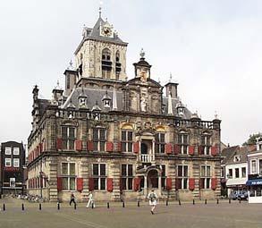
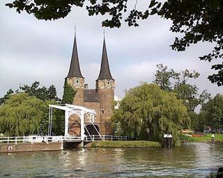
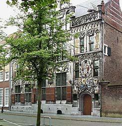
5 Painting by Egbert Lievensz van der Poel,, 1654 collection Stedelijk Museum Het Prinsenhof,, Delft April 25,
6 Gunpowder explosion, Delft 12 October 1654 r=250m Total destruction pound exploded (TNO: 40 ton TNT eq ) 200 houses not found back, hundreds more destroyed 100 fatal casualties (some reports 1000s) Blast could be heart up to Texel (> 100km North) Warehouse was in the city April 25,


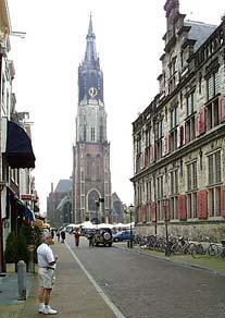
7 Old map <1654> New map April 25,
 April 25, 2005")
8 Some things remain constant Nearby child in chair eating apple not harmed Man was found alive under ruins after 36 hours Government support victims (free from taxation) Famous writer, Joost van den Vondel, creates poem Op het Onweder van 's Lants Bussekruit te Delft People learn: 6 years later the new warehouse was rebuilt 1,5 km outside city (more compartments) April 25,
9 People learn (1) After Tsunami: warning system should be created in Indian Ocean; see resolution of International Union of Geological Sciences (IUGS), recommends 1. establish system/procedures for early warning 2. include geological hazards at all educational levels 3. create/improve disaster management systems (monitor known indicators of natural disasters) 4. multidisciplinary/multinational research on geological hazards (improve understanding /forecasting) Tsunami caused by: earthquakes, volcanic eruptions, and landslides Most dangerous natural disaster: meteorite, 3 times all life on Earth was destroyed (prof. Stefan Luthi) April 25,

10 April 25,
 more stringent regulations, checking of regulations April 25,")
11 People learn (2) Some examples from the recent NL past: sea flooding Zeeland 1953 Delta-works river flooding Betuwe 1995 New program for river management and improved dikes firework disaster Enschede 2000 (4-5 ton TNT eq ) more stringent regulations, checking of regulations April 25,

12 April 25,
13 Geo-information Provides context awareness what/who is where Integration from multiple sources needed 3D and temporal aspect very important Mixed indoor (CAD) and outdoor (GIS) information Enables analysis (routes, flooding prediction, ) Provides clear interface the map Up to date information; monitoring by satellite sensors Positioning and navigation (GPS, Galileo) Location based services (LBS) April 25,
14 April 25,
15 Cooperation Organizers: ISPRS, UN OOSA, ICA, FIG, OGC, AGILE, EuroSDR Sponsors: GIN, Rijkswaterstaat, Intergraph, ESRI, Bentley, Octaaf Working groups: Spatial Data Integration for Emergency Services (ISPRS) Early Warning and Risk management (ICA) Risk and Crisis Management (OGC) Disaster Management Preventing Environmental Catastrophes by Spatial Planning and Land Management (FIG) Next events India (2006), Canada (2007), China (2008) final planning Joint Board of Spatial Information Societies April 25,

16 April 25,
17 Cooperating TU Delft departments, a sample Security and Disaster Management Delft Institute of Earth Observation and Space Systems Materials Science and Sustainable Construction Quantitative Imaging Group Computer Graphics & CAD/CAM Geo-Information Infrastructure GIS-technology April 25,


18 Pictures by Axel Smits April 25,
19 Gi4DM Programme 4 keynotes 22 presentations in plenary sessions 49 presentations in parallel sessions 50 poster presentations Special sessions include: Life Geo-web services high river water scenario Discussion panel (moderated by Orhan Altan, secretary general of the ISPRS) April 25,

20 April 25,
21 Symposium goal: treat disaster management in its entirety Technology: hard/software user requirements for geo-information information providers (data and standards). Aspects addressed: 1. state-of-the-art in Disaster Management 2. review of tools, software, geo-information sources, organizational structures and methods for work in crisis situations 3. outline of the drawbacks in current use of geo-information 4. some suggestions for future research directions April 25,
 3.")
22 Create relationships 1. During sessions and breaks 2. Reception (mayor of Delft) 3. Medieval symposium dinner April 25,

23 Enjoy! April 25,
Application of tsunami modelling for escape and refuge planning in Aceh (Indonesia)
") Application of tsunami modelling for escape and refuge planning in Aceh (Indonesia) Odelinde Nieuwenhuis, DHV BV Deepak Vatvani, Deltares (Delft Hydraulics) Jeroen Alberts, DHV BV Dick Jansen, DHV BV May
Application of tsunami modelling for escape and refuge planning in Aceh (Indonesia) Odelinde Nieuwenhuis, DHV BV Deepak Vatvani, Deltares (Delft Hydraulics) Jeroen Alberts, DHV BV Dick Jansen, DHV BV May
Geo-information for Disaster Management: 9/11 Lessons & Developments Since
 Geo-information for Disaster Management: 9/11 Lessons & Developments Since Michael J. Kevany Senior Vice President PlanGraphics, Inc. mkevany@plangraphics.com Introduction World Trade Center perspective
Seventh Session of the United Nations Committee of Experts on Global Geospatial Information Management
 Report of the Forum P a g e 1 Seventh Session of the United Nations Committee of Experts on Global Geospatial Information Management Report of the Forum Secure Land Rights and Smart Cities - Making It
The Profession between Cadastre and Citizen
 The Profession between Cadastre and Citizen Gerda Schennach, Austria Chair of FIG Commission 7 1 A human right UN DECLARATION OF HUMAN RIGHTS Article 17 par (1) Everyone has the right to own property alone
ICA and Cartography Today. Menno-Jan Kraak
 ICA and Cartography Today Menno-Jan Kraak Where are we today? Back to Rio The Map Members Internal relations External relations The map Working group on the International Map Year Members Estonia Georgia
Commission 7 Cadastre and Land Administration. Work Plan
 Commission 7 Cadastre and Land Administration Work Plan 2011 2014 Appendix to item 17.7 1. Title Cadastre and Land Administration 2. Terms of Reference Commission 7 deals with land administration and land
LAND ISSUES AND GEO-INFORMATION: RESPONDING POST DISASTER EARTHQUAKES IN NEPAL
 LAND ISSUES AND GEO-INFORMATION: RESPONDING POST DISASTER EARTHQUAKES IN NEPAL ARBIND MAN TULADHAR FACULTY OF GEO-INFORMATION SCIENCE AND EARTH OBSERVATION (ITC), UNIVERSITY OF TWENTE, THE NETHERLANDS,
Addressing Land Sector Opportunities with Geospatial Information in Nepal
 The 20th UNRCC-AP and the 4th UN-GGIM-AP 5-10 October 2015 Jeju Island, Republic of Korea Addressing Land Sector Opportunities with Geospatial Information in Nepal Krishna Raj BC Executive Director Land
FIG WORKING WEEK Athens, Greece May 22-27, 2004 MEETING PROGRAMME
 FIG WORKING WEEK Athens, Greece May 22-27, 2004 MEETING PROGRAMME Friday May 21, 2004 09:00-17:00 Council Meeting (by invitation only) 19:00- Council Dinner To be announced (by invitation only) Saturday
FIG Working Week 2008 and XXXI. General Assembly, Stockholm, Sweden, June FIG Commission 7 Annual Meeting 15 September 2008
 FIG Working Week 2008 and XXXI. General Assembly, Stockholm, Sweden, 14-19 June 2008 András s OSSKÓ FIG Commission 7 Annual Meeting Verona, Italy, 11-15 15 September 2008 The Working Week held in Stockholm,
The United States Mortgage Crisis and Cadastral Data. Donald Buhler, Bureau of Land Management. David Cowen, University of South Carolina
 The United States Mortgage Crisis and Cadastral Data Donald Buhler, Bureau of Land Management David Cowen, University of South Carolina What Have Americans Paid (and Maybe the Rest of the World) for Not
Utilizing 3D Building and 3D Cadastre Geometries for Better Valuation of Existing Real Estate
 Utilizing 3D Building and 3D Cadastre Geometries for Better Valuation of Existing Real Estate Umit ISIKDAG Beykent U., Turkey Mike HORHAMMER Oracle, USA Sisi ZLATANOVA, Peter VAN OOSTEROM TU Delft, The
Challenges for the multi purpose cadastre
 Jens RIECKEN, Markus SEIFERT, Germany Key words: Multi purpose cadastre, 3d-cadastre, land use, SDI, solar cadastre SUMMARY Over the past 30 years, with the progress of information technologies the development
The Usage of Geo-information and Technology in Disaster Management by Sub National Level Organizations Case Study - Ratnapura in Sri Lanka
 The Usage of Geo-information and Technology in Disaster Management by Sub National Level Organizations Case Study - Ratnapura in Sri Lanka Nirosha Priyangani Hapuarachchi March, 2008 The Usage of Geo-information
Innovations in Education at Faculty ITC and within Land Administration Programme
 Innovations in Education at Faculty ITC and within Land Administration Programme Prof. Jaap Zevenbergen, Vice-Dean Education at Faculty ITC, Prof. Land Administration dr. Dimo Todorovski, Course Coordinator
Acoustics 2012 Fremantle: Acoustics, Development and the Environment
 Fremantle: Acoustics, Development and the Environment The 2012 conference of the Australian Acoustical Society will be held in Fremantle, Western Australia, from November 21 to 23, 2012. ACOUSTICS 2012
COMMISSION 7 CADASTRE AND LAND MANAGEMENT WORK PLAN
 Appendix to item 34.7 FIG Congress in Washington, 19-26 April 2002 COMMISSION 7 CADASTRE AND LAND MANAGEMENT WORK PLAN 2002 2006 1. Title Cadastre and Land Management 2. Terms of Reference Commission 7
Developing a Prototype Marine Cadastre for Chedabucto Bay, Nova Scotia, Canada or is it St. Margaret s Bay?
 Developing a Prototype Marine Cadastre for Chedabucto Bay, Nova Scotia, Canada or is it St. Margaret s Bay? Dr. Michael Sutherland, CANADA Chair-Elect, Commission 4 FIG EILAT 2009, FIG WORKING WEEK, EILAT,
National Spatial Data Infrastructure development in Republic of Macedonia
 National Spatial Data Infrastructure development in Republic of Macedonia Sonja Dimova, state advisor for geomatics AGENCY FOR REAL ESTATE CADASTRE September 6-th, 2017, Strasbourg AREC competence for
Progress in modern cadastre Challenging existing models and paradigms
 Progress in modern cadastre Challenging existing models and paradigms Gerda Schennach, Austria Chair of FIG Commission 7 Federal Office of Metrology and Surveying, Austria The Value of Cadastre for Society
Commission Chair
 Commission no. 8 Nominee Name Country Marije Louwsma Netherlands Contact Address PO Box 9046 7300 GH Apeldoorn The Netherlands E-mail address marije.louwsma@kadaster.nl Age 38 Degrees and educational background
2nd ARTES Applications Workshop Session: Security and Civil Protection
 2nd ARTES Applications Workshop Session: Security and Civil Protection N. Hübner Head of Feasibility Studies Section Integrated and Telecom related Applications Department European Space Agency Harwell
We will post program changes and additional information on the Board of CIDOC Booth as well as on our facebook page CIDOC Events.
 Dear CIDOC2013 Participant, Welcome to 2013 CIDOC which will take place in Rio de Janeiro, Brazil, from 10-17 August, as part of the ICOM General Conference. Our focus this year is on outreach and networking
FAO/FIG Forum FIG Working Week 2012 Rome, Italy, 6-10 May 2012
 15 April 2012 FAO/FIG Forum FIG Working Week 2012 Rome, Italy, 6-10 May 2012 General Voluntary Guidelines on the Responsible Governance of Tenure of Land, Fisheries and Forests in the Context of National
From LADM/STDM to a spatially enabled society: a vision for Harry UITERMARK, Peter VAN OOSTEROM, Jaap ZEVENBERGEN and Christiaan LEMMEN
 From LADM/STDM to a spatially enabled society: a vision for 2025 Harry UITERMARK, Peter VAN OOSTEROM, Jaap ZEVENBERGEN and Christiaan LEMMEN Introduction (1) Vision is a co-production Founding fathers
EduMapping + JobMapping
 EduMapping + JobMapping Frans Rip Centre for Geoinformation, Wageningen UR 18 April 2011 1. What is EduMapping? Present GI-course descriptions Toekomst: mèt etiket Assessment by teacher Course content
From LADM/STDM to a spatially enabled society: a vision for Harry UITERMARK, Peter VAN OOSTEROM, Jaap ZEVENBERGEN and Christiaan LEMMEN
 From LADM/STDM to a spatially enabled society: a vision for 2025 Harry UITERMARK, Peter VAN OOSTEROM, Jaap ZEVENBERGEN and Christiaan LEMMEN Introduction (1) Presentation is a coproduction Founding fathers
The Message FIG-WB Partnership on Land Governance in Support of the Global Agenda
 FIG-WB Partnership on Land Governance in Support of the Global Agenda Prof. Stig Enemark, Denmark President 2007-2010 Mr. Teo Chee Hai, Malaysia President Elect 2011-2014 WORLD BANK LAND GROUP, WASHINGTON,
The Added Value of Geospatial Information in Disaster and Risk Management: A Case Study on the 2009 Flooding in Namibia
 The Added Value of Geospatial Information in Disaster and Risk Management: A Case Study on the 2009 Flooding in Namibia Summary Tessa Anne Belinfante, M.Sc. VU University Amsterdam Objective and Approach
BULGARIAN CADASTRE A GUARANTEE FOR THE OWNERSHIP RIGHTS IN IMMOVABLE PROPERTIES
 4 TH INTERNATIONAL CONFERENCE RECENT PROBLEMS IN GEODESY AND RELATED FIELDS WITH INTERNATIONAL IMPORTANCE February 28 - March 2, 2007, Inter Expo Centre, Sofia, Bulgaria BULGARIAN CADASTRE A GUARANTEE
Greetings from Denmark. Property Rights, Restrictions and Responsibilities - A Global Land Management Perspective. Wonderful Copenhagen
 Property Rights, Restrictions and Responsibilities - A Global Land Management Perspective Greetings from Denmark 43,000 sq km Prof. Stig Enemark President Aalborg University, Denmark Aalborg Copenhagen
A Geocoded Cadastral Fabric as a Precondition for a Sustainable Land Management System
 A Geocoded Fabric as a Precondition for a Sustainable Land Management System Gottfried KONECNY, Germany; J.P. LAUZON, Canada; Abdul Salam MOHAMMED, India Key words: SDI,, Parcel Boundaries, GPS-GNSS, Land
STATUS REPORT
 Working Group 3 Land Administration STATUS REPORT 2006-2009 2009 Prof Ian Williamson (Chair) Mr Ahmad Fauzi Nordin (Vice Chair) Assoc. Prof Abbas Rajabifard (Vice Chair) 18th UNRCC-AP Conference Bangkok
The Multipurpose Marine Cadastre A Tool for Planning & Decision Making in the Marine Environment
 The Multipurpose Marine Cadastre A Tool for Planning & Decision Making in the Marine Environment Christine Taylor Minerals Management Service (MMS) Brian Smith NOAA Coastal Services Center Maurice Hill
Learning from land suitability analysis and Dutch spatial policy for sustainable land use in Japan
 Learning from land suitability analysis and Dutch spatial policy for sustainable land use in Japan Toru Nagayama 22 January 2009 GIS Research Group Seminar, University of Tsukuba Highlights from : Nagayama.,
The Bertram Broberg Memorial Fund
 The Bertram Broberg Memorial Fund Annual Newsletter- August 2015 Prepared for circulation at the 5th Bertram Broberg Symposium on Mechanics of Materials in Karlskrona, Sweden from 24-25 August 2015 Dear
Spatially Enabled Society Role of the Cadastre
 armasuisse Bundesamt für Landestopografie swisstopo Swiss Federal Directorate for Cadastral Surveying Spatially Enabled Society Role of the Cadastre XXIV FIG International Congress 2010 FIG-Task Force
Developing a Prototype Marine Cadastre for Chedabucto Bay, Nova Scotia
 Michael SUTHERLAND and Susan NICHOLS, Canada Keywords: Marine Cadastre; Marine Information System; Coastal Zone Management; Ocean Governance; Administration of Marine Spaces ABSTRACT The idea of a marine
Building a national SDI. Approach and strategy in The Netherlands
 Agenda 1. NSDI vision and implementation strategy 2. NSDI playing field 3. Standards framework for the NSDI 4. National SDI components for IM Information model public safety SDI Portal for public safety
FACTS ANDFIGURES. ITC: gateway to international knowledge exchange focusing on capacity building and institutional development
 FACTS ANDFIGURES 2008 ITC: gateway to international knowledge exchange focusing on capacity building and institutional development Introduction Geo-information management, worldwide and innovative The
FIG Working group Valuation and Real estate management through Fin-tech. Manohar Velpuri
 FIG Working group 9.2 - Valuation and Real estate management through Fin-tech Manohar Velpuri Introduction Projects Timeline and working group project updates II plenary - ISO TC 307 report Integration
INDIAN INSTITUTE OF TECHNOLOGY ROORKEE. Presentation on REAL TIME CADASTRAL SURVEYING SOLUTION WITH A SPECIAL IMPHESIS TO MODERN GPS TECHNOLOGY.
 INDIAN INSTITUTE OF TECHNOLOGY ROORKEE Presentation on REAL TIME CADASTRAL SURVEYING SOLUTION WITH A SPECIAL IMPHESIS TO MODERN GPS TECHNOLOGY By: Prof. Kamal Jain, Dept. of Civil Engg. IIT-Roorkee AIM
Alberta Flood Hazard Identification Program
 Alberta Flood Hazard Identification Program Peter Onyshko, P.Eng., CFM River Forecast Section Alberta Environment and Parks November 5, 2015 Flood Hazard Identification Program Presentation Outline Introduction
Ignition for Fit For Purpose Land Administration in Nepal
 Presented at the FIG Working Week 2017, May 29 - June 2, 2017 in Helsinki, Finland Ignition for Fit For Purpose Land Administration in Nepal Paula Dijkstra (Netherlands), David Mitchell, Rohan Bennett
MEMORANDUM OF UNDERSTANDING between THE UNITED NATIONS HUMAN SETTLEMENTS PROGRAMME (UN-HABITAT) and THE INTERNATIONAL FEDERATION OF SURVEYORS (FIG)
 and THE INTERNATIONAL FEDERATION OF SURVEYORS (FIG)") Appendix to item 20.2 MEMORANDUM OF UNDERSTANDING between THE UNITED NATIONS HUMAN SETTLEMENTS PROGRAMME (UN-HABITAT) and THE INTERNATIONAL FEDERATION OF SURVEYORS (FIG) WHEREAS the United Nations Human
Appendix to item 20.2 MEMORANDUM OF UNDERSTANDING between THE UNITED NATIONS HUMAN SETTLEMENTS PROGRAMME (UN-HABITAT) and THE INTERNATIONAL FEDERATION OF SURVEYORS (FIG) WHEREAS the United Nations Human
Marine Spatial Data Infrastructure (MSDI) & The Marine Cadastre Application. April 10, 2018
 & The Marine Cadastre Application. April 10, 2018") Marine Spatial Data Infrastructure (MSDI) & The Marine Cadastre Application April 10, 2018 A Collaborative Pilot Project Vision of CHS: A framework of geographic data, metadata, users and tools Intent
Marine Spatial Data Infrastructure (MSDI) & The Marine Cadastre Application April 10, 2018 A Collaborative Pilot Project Vision of CHS: A framework of geographic data, metadata, users and tools Intent
Unified Land Administration for a Better Spatial Infrastructure
 Unified Land Administration for a Better Spatial Infrastructure Gyula IVÁN Institute of Geodesy, Cartography & Remote Sensing FÖMI (HUNGARY) Open Symposium 30th Korean Cadastral Seminar & FIG Commission
The Doubletree Hotel University Room Madison, Wisconsin, USA June Programme
 Annual Meeting 2005 The Doubletree Hotel University Room Madison, Wisconsin, USA 18-25 June 2005 Programme Saturday June 18, 2005 19:00-21:00 Informal welcome drink at the Badgerland Bar & Grill of the
Spatial Enablement and the Response to Climate Change and the Millennium Development Goals
 Spatial Enablement and the Response to Climate Change and the Millennium Development Goals Prof. Stig Enemark President Aalborg University, Denmark 18th UNITED NATIONS REGIONAL CARTOGRAPHIS CONFERENCE
The Role of Geodesy in Modernization of Croatian Railways
 Igor POLJANAC, Rinaldo PAAR and Vlado CETL, Croatia Key words: railways, modernization, infrastructure, and geodesy. SUMMARY At the beginning of the 90-s in the last century the changes in the economic
Building Integrated Land Information Systems and Development of NSDI
 Stig JÖNSSON, Sweden Key words: Land administration, land information systems, property formation, spatial data infrastructure, Inspire, institutional cooperation SUMMARY Lantmäteriet the Swedish agency
GAUSSCAD A WEBGIS APPLICATION FOR COLLECTING CADASTRAL DATA
 M.M. Moise GaussCAD a WebGIS Application for Collecting Cadastral Data GAUSSCAD A WEBGIS APPLICATION FOR COLLECTING CADASTRAL DATA Mihai-Mircea MOISE, S.C. GAUSS S.R.L., mihai.moise@gauss.ro Abstract:
Institutional Arrangements In Geoinformation: Influence of Legal and Policy Issues **
 ADVANCE UNEDITED VERSION UNITED NATIONS E/CONF.103/24 ECONOMIC AND SOCIAL COUNCIL Tenth United Nations Regional Cartographic Conference for the Americas New York, 19-23, August 2013 Item 6 (a) of the provisional
PANAFRICA GEOINFORMATION SERVICES PLC ETHIOPIA
 PANAFRICA GEOINFORMATION SERVICES PLC ETHIOPIA Tenets PanafricaGIS is a technology-enthusiast company operated by experienced professionals in the field of geo-information. We believe a sustained and inclusive
3.11 East Japan Earthquake and Topics related to Land management. Masaru Kaidzu Ibaraki-ken EX-JICA Expert Association
 3.11 East Japan Earthquake and Topics related to Land management Masaru Kaidzu Ibaraki-ken EX-JICA Expert Association The 2011 off the Pacific coast of Tohoku Earthquake Date-Time: March 11, 2011 14:46
SHELTER PROGRAM UN-HABITAT ARCADIS SHELTER PARTNERSHIP UN-HABITAT ARCADIS PARTNERSHIP JANUARY 5, 2017 JANUARY 5, 2017
 SHELTER PROGRAM UN-HABITAT ARCADIS SHELTER PARTNERSHIP PROGRAM 2016-2017 UN-HABITAT ARCADIS PARTNERSHIP 2016-2017 JANUARY 5, 2017 JANUARY 5, 2017 2 Shelter in 2016 As a global company, Arcadis understands
10 th International SOEP User Conference 2012
 2012 10 th International SOEP User Conference 2012 Berlin, June 28 to 29, 2012 The 10th international SOEP User Conference took place in Berlin on June 28-29, 2012. Over 160 participants from 10 countries
PCC conference Tällberg. Aspects on development cooperation
 PCC conference Tällberg Aspects on development cooperation PCC conference Tällberg WHO I AM Anders Åberg, Project Leader Posted over seas 10 years Tanzania 1978 1980 Vietnam 1987 1990 Laos 2004 2008 Now
5 th WAVO VALUATION CONGRESS
 5 th WAVO VALUATION CONGRESS Meeting the Valuation Needs of a Globalised World 24-26 November 2010 Concorde Hotel Singapore Host World Association of Valuation Organisations Singapore Institute of Surveyors
8 th FIG Regional Conference Montevideo, Uruguay, November Call for Papers
 8 th FIG Regional Conference Montevideo, Uruguay, 26-29 November 2012 Dear Friend and Colleague, Call for Papers It is our privilege and honour to invite you to the 8 th FIG Regional Conference in Montevideo,
National Report. Submitted by Cyprus **
 UNITED NATIONS E/CONF.97/5/CRP. 12 ECONOMIC AND SOCIAL COUNCIL Seventeenth United Nations Regional Cartographic Conference for Asia and the Pacific Bangkok, 18-22 September 2006 Item 6 (b) of the provisional
National Technical University of Athens School of Rural and Surveying Engineering
 National Technical University of Athens School of Rural and Surveying Engineering INFORMAL SETTLEMENTS REAL ESTATE MARKET NEED FOR GOOD LAND ADMINISTRATION AND PLANNING FIG COM3, UNECE CHLM & WPLA JOINT
Advances in Modern Land Administration Cadastre 2014 in the Year 2006
 Advances in Modern Land Administration Cadastre 2014 in the Year 2006 Winfried HAWERK, Germany Key words: E-Land Administration, IT renewal strategies SUMMARY FIG Commission 7 Working Group 7.3 deals with
Results of Central European Land Knowledge Center (CELK) Activities
 Activities") Results of Central European Land Knowledge Center (CELK) Activities András OSSKÓ, Hungary Key words :CELK Center, Property Rights and Land Market Development, Networking, direct knowledge transfer SUMMARY
Results of Central European Land Knowledge Center (CELK) Activities András OSSKÓ, Hungary Key words :CELK Center, Property Rights and Land Market Development, Networking, direct knowledge transfer SUMMARY
GIS & GPS Applications in Valuation/Appraisal Assessments
 GIS & GPS Applications in Valuation/Appraisal Assessments Simon ADCOCK, Australia Key words: GIS, GPS, mass assessments, 3-dimensional, modelling. SUMMARY The development of GIS and GPS systems has substantially
Agenda. Introduction to participants First Meeting UN-GGIM - GROUP OF EXPERTS ON LAND ADMINISTRATION AND MANAGEMENT UN-GE-LAM
 First Meeting UN-GGIM - GROUP OF EXPERTS ON LAND ADMINISTRATION AND MANAGEMENT Kees de Zeeuw, The Netherlands Chair Mahashe Chaka, Lesotho Co-Chair Brent Jones, ESRI (USA) -Rapporteur Agenda Opening Introduction
Introduction to ERDAS Imagine
 Course: Remote Sensing Basic Theory & Image Processing Methods 19-23 September 2011 Introduction to ERDAS Imagine Michiel Damen (damen@itc.nl) UNIVERSITY of TWENTE - Michiel Damen 1 Contents About ERDAS
ITC. Geo-Information Science & Earth Observation... and Capacity Building
 ITC Geo-Information Science & Earth Observation... and Capacity Building Rolf A. de By International Institute for Geo-Information Science and Earth Observation, ITC II Taller Internacional de la Red de
Presented at the FIG Congress 2018, May 6-11, 2018 in Istanbul, Turkey
 Presented at the FIG Congress 2018, May 6-11, 2018 in Istanbul, Turkey 5 Bibliometric Analysis of Articles Presented Under Commission 7: A Case of the 25th Fig Congress in Malaysia in 2014 Zeynel Abidin
Annual Meeting II/2016 FIG Commission 7 Cadastre & Land Management. Report
 Annual Meeting II/2016 FIG Commission 7 Cadastre & Land Management Report 1 Structure Chair G. Schennach (AT) V-Chair for communications, social media, web Hyunsook LEE (KR) WG 7.1 Fit-For-Purpose LA Ch.
REGISTRATION OF PROPERTIES IN STRATA
 REGISTRATION OF PROPERTIES IN STRATA REPORT ON THE WORKING SESSIONS INTRODUCTION A cadastre is usually, and in most countries, a parcel-based, and up-to-date land information system containing records
Esri Middle East and Africa User Conference. December Abu Dhabi, UAE. Land Administration. Mark Baker
 Esri Middle East and Africa User Conference December 10 12 Abu Dhabi, UAE Land Administration Mark Baker Our Agenda 0900 0930 Welcome Mark Baker, Esri 0930 1030 New Directions The New Addressing System
Development of Cadastral Survey and Land Ownership Registration System in Mongolia
 Development of Cadastral Survey and Land Ownership Registration System in Mongolia M.Saandar,, Ph. D Vice President, the Mongolian Association of Surveying and Mapping, ( As National Member of FIG ) MonMap
Modernizing Land Administration Systems
 Presented at the FIG Congress 2018, May 6-11, 2018 in Istanbul, Turkey Modernizing Land Administration Systems B r e n t J o n e s P E, PLS E s r i Land Administration Systems GIS is the Technology Platform
INTERNATIONAL CONFERENCE GEOTEC HANOI 2011 "Geotechnics for Sustainable Development", in Hanoi, 6th-7th October 2011
 CONFERENCE NEWS INTERNATIONAL CONFERENCE GEOTEC HANOI 2011 "Geotechnics for Sustainable Development", in Hanoi, 6th-7th October 2011 Geotec Hanoi 2011, an international conference on Geotechnics for Sustainable
Building cities. Vernon Henderson, Tanner Regan and Tony Venables January 24, 2016
 Building cities Vernon Henderson, Tanner Regan and Tony Venables January 24, 2016 Motivation Buildings and land are typically about 60% of private wealth in nations. Growing cities require new housing
3rd ANNUAL INTERNATIONAL CONSTRUCTION MANAGEMENT DAY AT GMIT
 3rd ANNUAL INTERNATIONAL CONSTRUCTION MANAGEMENT DAY AT GMIT MONDAY 11th MARCH 2013 GALWAY - MAYO INSTITUTE OF TECHNOLOGY DUBLIN ROAD, GALWAY LIBRARY / IT BUILDING, RECEPTION 9.00 AM CONSTRUCTION SURVEYING
Shaping the Change. FIG Today. FIG is growing and activities are increasing. Surveyors contribution is essential for the development of a country
 Shaping the Change FIG Vision, Mission and Activities - Promoting Sustainable Development- Luncheon Address at HKIS, 2 November 2006 Univ.Prof. Dr. Holger Magel, FIG President Chair of UN-Habitat Professionals
The Strategic Plan can be viewed by clicking this link.
 What is the purpose of the Land Information Office? Many of Brown County's most basic services rely on accurate and up-to-date land information. Emergency response, resource conservation, infrastructure
HABITAT PROFESSIONALS FORUM ARCHIVES CONTENT
 HABITAT PROFESSIONALS FORUM ARCHIVES 1998-2008 CONTENT FILE 1. CONTENT FILE 2. INTRODUCTION FILE 3. A. Erim; The Story A Chronology PART I EVENTS AND PRESENTATIONS FILE 4. YEARS 1998 2002 Dr. Irene Wiese-von
Meeting the Changing National Geospatial Information Needs. Palitha Udayakantha Surveyor General - Sri Lanka
 Meeting the Changing National Geospatial Information Needs Palitha Udayakantha Surveyor General - Sri Lanka Sri Lanka Location Latitude 5 55 10-9 50 6 North Longitude 79 31 19-81 52 36 East Area 65610
Cadastral Futures building a new vision for the nature and role of cadastres. XXIV FIG International Congress Sydney, April 11-15
 Cadastral Futures building a new vision for the nature and role of cadastres XXIV FIG International Congress Sydney, April 11-15 Rohan Bennett, Abbas Rajabifard, Mohsen Kalantari, Jude Wallace, Ian Williamson
Egyptian Nationwide Title Cadastre System
 Kholoud SAAD, Egypt Key words: Cadastre, Registration, Urban, Rural, National Cadastre, Automation, reengineering. SUMMARY With growing need for integrated information, Enterprise Solutions has become
Project Management Forum. Eilat 2009
 Project Management Forum Eilat 2009 May 2009 FIG Working Week 1 Purpose To build on the sessions in Hong Kong and Stockholm To review the elements of PM To review examples of the stages of development
Presented by: Stewart Information International, Inc. Jack McKenna
 Presented by: Stewart Information International, Inc. Jack McKenna Held at the: 2007 ESRI Survey & Engineering GIS Summit San Diego Convention Center San Diego, California June 16-19, 2007 Integrating
Economic and Social Council 6 July 2018
 1 ADVANCE UNEDITED VERSION UNITED NATIONS E/C.20/2018/12/Add.1 Economic and Social Council 6 July 2018 Committee of Experts on Global Geospatial Information Management Eighth session New York, 1-3 August
Commission 7, Land Administration and IT. Paul van der Molen INTERNATIONAL INSTITUTE FOR GEO-INFORMATION SCIENCE AND EARTH OBSERVATION
 Commission 7, Land Administration and IT Paul van der Molen INTERNATIONAL INSTITUTE FOR GEO-INFORMATION SCIENCE AND EARTH OBSERVATION FIG Commission 7 on cadastre and land management Study Visits (e.g.
DIGITAL CADASTRAL MAP: A MULTIPURPOSE TOOL FOR SUSTAINABLE DEVELOPMENT
 DIGITAL CADASTRAL MAP: A MULTIPURPOSE TOOL FOR SUSTAINABLE DEVELOPMENT Moha ELAYACHI and Prof. El Hassane SEMLALI, Morocco Key words: cadastral information, digital cadastral map, design, implementation,
EXPLORING OPTIONS FOR STANDARDISATION OF PROCESSES AND TRANSACTIONS IN LAND ADMINISTRATION
 EXPLORING OPTIONS FOR STANDARDISATION OF PROCESSES AND TRANSACTIONS IN LAND ADMINISTRATION CHRISTIAAN LEMMEN (1),(2), EVA-MARIA UNGER (2), PETER VAN OOSTEROM (3), MOHSEN KALANTARI (4) AND KEES DE ZEEUW
Universal Geo-database Connector Interface Component (UG-CIC) For Virtual Web-base GIS Server Essential For Real Estate Industry Uses
 For Virtual Web-base GIS Server Essential For Real Estate Industry Uses") Universal Geo-database Connector Interface Component (UG-CIC) For Virtual Web-base GIS Server Essential For Real Estate Industry Uses Jad Jarroush & Dr. Kobi Zaid Zaid Orniv Group L.T.D Israel kobi_z@zaidorniv.co.il
Universal Geo-database Connector Interface Component (UG-CIC) For Virtual Web-base GIS Server Essential For Real Estate Industry Uses Jad Jarroush & Dr. Kobi Zaid Zaid Orniv Group L.T.D Israel kobi_z@zaidorniv.co.il
Re-engineering engineering the cadastre to support e-governmente
 Centre for SDIs and Land Administration Department of Geomatics Re-engineering engineering the cadastre to support e-governmente Ian Williamson UN sponsored Third Land Administration Forum, Tehran, 2009
Safe Waterfront Access, PID Council Report -2 - May 10, 2016 BACKGROUND
 14.3.1 Safe Waterfront Access, PID 00560789 Council Report -2 - May 10, 2016 BACKGROUND A staff information report dated April 11, 2016 regarding safe waterfront access at PID 00560789 was before the Halifax
Authorts Short Biography
 Andrade, Rafael Espín, PhD. is Titular Professor of the Technological Management Studies Centre in the Polytechnic University Jose Antonio Echeverria CUJAE. Coordinator of the Iberian American Network
Coastal Zone Management Land Administration Capacity Building
 Closing Address Prof. Stig Enemark President 6th FIG Regional Conference Coastal Areas and Land Administration - Building the Capacity San José, Costa Rica, 12 15 November 2007 Three Main Themes Coastal
2012 US/ICOMOS International Symposium
 2012 US/ICOMOS International Symposium Confluence of Cultures: World Heritage in the Americas May 31 June 2 in San Antonio, Texas An Official Event of UNESCO s World Heritage Convention 40 th Anniversary
Real Estate Administration at the Vancouver Port Authority (VPA) Presentation by Ron McMillan - GIS/LIS Coordinator December 13, 2004
 Presentation by Ron McMillan - GIS/LIS Coordinator December 13, 2004") Real Estate Administration at the Vancouver Port Authority (VPA) Presentation by Ron McMillan - GIS/LIS Coordinator December 13, 2004 Introduction Overview of the Vancouver Port Authority (VPA) How CAD
Real Estate Administration at the Vancouver Port Authority (VPA) Presentation by Ron McMillan - GIS/LIS Coordinator December 13, 2004 Introduction Overview of the Vancouver Port Authority (VPA) How CAD
Ecuador and last year in Guangzhou, China emphasizing the sub-theme Innovative Governance, Open Cities.
 Expression of Interest 18th December 2018 GLOBAL OBSERVANCE OF THE ANNUAL WORLD CITIES DAY 2019 1. Introduction The United Nations has designated every 31 of October as World Cities Day (WCD). UN-Habitat
Croatian SDI: a Tool for Accelerated Development of the Geo-Conscious Society
 STATE GEODETIC ADMINISTRATION Croatian SDI: a Tool for Accelerated Development of the Geo-Conscious Society Prof.Dr.Sc. Željko Bačić, Mr.Sc. Ljerka Rašić FIG Working Week 2009 - Surveyors Key Role in Accelerated
PREPARING SURVEY TENDER GIS DATABASE OUTCOMES
 PREPARING SURVEY TENDER SPECIFICATIONS FOR PROJECT GIS DATABASE OUTCOMES Presentation by Ian Harper GEODATA AUSTRALIA ESRI User Conference 2009 24 st July 2009 BACKGROUND GIS databases now provide a more
Cadastre in Addis Ababa. Status and future development
 Status and future development Dr.-Ing. Paul Hartfiel Mülheim, 1. Oct. 2010-1 - Addis Ababa Capital of Ethiopia Area population 540 km² > 3,200,000 (rapidly growing) 2,300,000 in 1994 > 22% of all urban