River outlook development project
|
|
|
- Albert Page
- 5 years ago
- Views:
Transcription


1 Property Information 3 2 Legal Description 30 Long St Lot 2 DP Certificate of Title CB527/52 45 Bamford St PT Lot 3 DP Certificate of Title CB6D/ Bamford St Lot 1 DP Certificate of Title CB526/244 Rates Capital Valuation Land Value Improvements Land Area Floor Area Tenure CERA Zoning $5, (total) $810,000 (total) $585,000 (total) $225,000 (total) 2,583m 2 (more or less) 190m 2 (more or less) Fee Simple Green Zone TC 2, Yellow Chattels Fixed floor coverings, Blinds, Curtains, Light fittings, Oven - electric, Garden shed bayleys.co.nz/ Deadline Sale (unless sold prior) 1pm, Wed 21 Nov Deans Ave, Chch View by appointment Angela Webb angela.webb@bayleys.co.nz Jeremy Speight jeremy.speight@bayleys.co.nz WHALAN AND PARTNERS LTD, BAYLEYS, LICENSED UNDER THE REA ACT 2008 Woolston 45 Bamford Street River outlook development project The contents of this document do not form part of any contract. This document has been compiled using information provided by third parties, and Bayleys accepts no responsibility for its accuracy or completeness. In all cases, interested parties should conduct their own verification of the information in this document, as well as their own investigation and analysis of the property described in it. All parties are urged to take legal advice before entering into any contract or agreement in relation to the property described herein. bayleys.co.nz


2 Currently the land is divided into three freehold titles, including a three bedroom house, two bedroom house and a vacant section. The empty section is presently leased at $200pw, the two bedroom is leased at $365pw and the three bedroom is returning $275pw, giving a total holding income of $840 per week. Zoned within the Residential Suburban Density Transition Zone and Land Zone Technical Category 2 (TC2). Strategically purchased over a period of years these properties are now offered for a combined sale as a develop project or land banking opportunity. Both houses are fully insured and had all EQC work completed and signed off. With retirement looming and after years of property development and ownership the owner has decided it is time to allow the next generation the opportunity to make a mark on Christchurch. The popular Tannery shopping complex close by, the river outlook and an easy commute to the inner city, this development with be a star feature in the Christchurch market place. Superbly positioned this 2,583m 2 (approx.) block of development land is now available to purchase and comes complete with preliminary Architect designs for eight townhouses. bayleys.co.nz
3 This information Memorandum, title or other supplementary property information (the Information ) has been prepared by Whalan and Partners Limited, trading as Bayleys ( Bayleys ) as agent for the Vendor. The Information contains information that is publicly available and/or sourced from third parties and capable of independent verification. It has been prepared solely to assist interested parties in deciding whether to further their interest in the Property and Whalan and Partners Limited is acting as a conduit and merely passing this information over. Prospective purchasers must not confine themselves to the contents of the Information but should, in conjunction with their professional advisors, make their own evaluation of the Property and conduct their own investigation, analysis and verification of the data contained in the Information and otherwise concerning the Property. Such evaluation should extend to and include whether there has been a change in the affairs or prospects of the Property since the date of the Information or since the date as at which any information contained in the Information is expressed to be applicable. Bayleys and the Vendor have not verified any of the detail contained in the Information and Bayleys and the Vendor make no representation or warranty as to the accuracy or completeness of the information and neither Bayleys nor the Vendor accept and/or shall have any liability whatsoever for the accuracy of any part of the information including any liability for any statements, opinions, information or matters (expressed or implied) arising out of, contained in or derived from the Information, or any omissions from, or failure to correct any information, or any other written or oral communications transmitted to any recipient of the Information in relation to the Property.
4
5
6
7
8
9
10 Land Information Memorandum 30 Long Street LIM number: Page 1
11 Land Information Memorandum Application details Please supply to Client reference Phone number Fax number Date issued Date received BAYLEYS REAL ESTATE PO BOX MERIVALE CHRISTCHURCH 8146 MC (03) October October 2018 Property details Property address 30 Long Street Valuation roll number Valuation information Capital Value: $ Land Value: $ Improvements Value: $ Please note: these values are intended for Rating purposes Legal description Lot 2 DP Council references Debtor number Rate account ID LIM number Property ID Long Street LIM number: Page
12 Land Information Memorandum Document information This Land Information Memorandum (LIM) has been prepared for the purpose of section 44A of the Local Government Official Information and Meetings Act 1987 (LGOIMA). It is a summary of the information that we hold on the property. Each heading or "clause" in this LIM corresponds to a part of section 44A. Sections 1 to 11 contain all of the information known to the that must be included under section 44A(2) LGOIMA. Any other information concerning the land as the Council considers, at its discretion, to be relevant is included at section 11 of this LIM (section 44A(3) LGOIMA). The information included in this LIM is based on a search of Council records only and there may be other information relating to the land which is unknown to the Council. Council records may not show illegal or unauthorised building or works on the property. The applicant is solely responsible for ensuring that the land is suitable for a particular purpose. If there are no comments or information provided in any section of this LIM this means that the Council does not hold information on the property that corresponds to that part of section 44A. A LIM is only valid at the date of issue as information is based only upon information the Council held at the time of that LIM request being made. Property file service This Land Information Memorandum does not contain all information held on a property file. Customers may request property files by phoning the Council's Customer Call Centre on (03) , or visiting any of the Council Service Centres. For further information please visit. To enable the Council to measure the accuracy of this LIM document based on our current records, we would appreciate your response should you find any information contained therein which may be considered to be incorrect or omitted. Please telephone the Customer Call Centre on (03) Long Street LIM number: Page
13 Land Information Memorandum A search of records held by the Council has revealed the following information: 1. Special features and characteristics of the land Section 44A(2)(a) LGOIMA. This is information known to the Council but not apparent from the district scheme under the Town and Country Planning Act 1977 or a district plan under the Resource Management Act It identifies each (if any) special feature or characteristic of the land concerned, including but not limited to potential erosion, avulsion, falling debris, subsidence, slippage, alluvion, or inundation, or likely presence of hazardous contaminants. ( For enquiries, please phone (03) or visit. ECan Liquefaction Assessment ECan holds indicative information on liquefaction hazard in the Christchurch area.information on liquefaction can be found on the ECan website at or by calling ECan customer services on Ph The may require site-specific investigations before granting future subdivision or building consent for the property, depending on the liquefaction potential of the area that the property is in. Consultant Report Available Land Information New Zealand (LINZ) engaged Tonkin and Taylor to provide a Geotechnical Report on Ground Movements that occurred as a result of the Canterbury Earthquake Sequence. The report indicates this property may have been effected by a degree of earthquake induced subsidence. The report obtained by LINZ can be accessed on their website at information-for-canterbury-surveyors Coastal Hazard Inundation The Council has a report, Coastal Hazard Assessment for Christchurch and Banks Peninsula (2017), that indicates this property or part of this property may be susceptible to coastal inundation (flooding by the sea). The 2017 report considers four sea level rise scenarios through to the year A copy of the 2017 report and other coastal hazard information can be found at /coastalhazards. Predicted 1 in 50 Year Flood Extent This property, or parts of this property are predicted to be within the extent of a 1 in 50 year flood event. For new developments a minimum finished floor level may be required for flood limitation purposes under the Building Code. For more information please refer to ( or phone Pool PoolID Number: This property has a Private In-Ground Swimming Pool which has been Removed. This does not necessarily mean the below ground structure of the pool has been removed. Distant Source Tsunami - Area of Potential Inundation ECan commissioned a report on the inundation of the Southern Pegasus Bay coast in the event of a distant source tsunami (e.g. across Pacific ocean). The model simulates worst case flooding from a distant source tsunami (not a regional/local source tsunami). This property is situated in an area identified in the report as an area of potential inundation in the event of a distant source tsunami. The primary use of the information is to inform tsunami evacuation planning. For further information please contact ECan at or call (03) or Long Street LIM number: Page
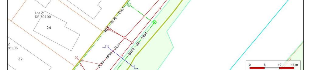
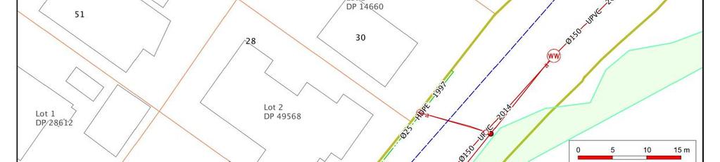
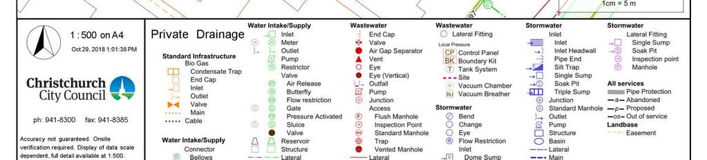
14 Land Information Memorandum 2. Private and public stormwater and sewerage drains Section 44A(2)(b) LGOIMA. This is information about private and public stormwater and sewerage drains as shown in the Council's records. ( For stormwater and sewerage enquiries, please phone (03) or visit. Related information The dwelling/building is shown to be served by a sewer drain. No details of the private stormwater system serving this property are shown on the plan or on Council records. 30 Long Street LIM number: Page
15 Land Information Memorandum 3. Drinking Water Supply Section 44A(2)(ba) and (bb) LGOIMA. This is information notified to the Council about whether the land is supplied with drinking water, whether the supplier is the owner of the land or a networked supplier, any conditions that are applicable, and any information the Council has about the supply. ( For water supply queries, please phone (03) or visit. Water Supply is the networked supplier of water to this property. This property is connected to the Water Supply. The conditions of supply are set out in the Water Supply, Wastewater & Stormwater Bylaw (2014), refer to. 30 Long Street LIM number: Page
16 Land Information Memorandum 4. Rates Section 44A(2)(c) LGOIMA. This is information on any rates owing in relation to the land. ( For rates enquiries, please phone (03) or visit. (a) Annual rates Annual rates to 30/06/2019: $ 1, Instalment Amount Date Due Instalment 1 $ /09/2018 Instalment 2 $ /12/2018 Instalment 3 $ /03/2019 Instalment 4 $ /06/2019 Rates owing as at 29/10/2018: $ (b) Excess water charges $ 0.00 ( For water charge enquiries, please phone (03) or visit. (c) Final water meter reading required? No Reading Required ( To arrange a final water meter reading, please phone (03) or visit. 30 Long Street LIM number: Page
17 Land Information Memorandum 5. Consents, certificates, notices, orders, or requisitions affecting the land and buildings Section 44A(2)(d) LGOIMA. This is information concerning any consent, certificate, notice, order, or requisition, affecting the land or any building on the land, previously issued by the Council. Section 44A(2)(da) LGOIMA. The information required to be provided to a territorial authority under section 362T(2) of the Building Act There is currently no information required to be provided by a building contractor to a territorial authority under section 362T(2) of the Building Act The Building (Residential Consumer Rights and Remedies) Regulations 2014 only prescribed the information that must be given to the clients of a building contractor. ( For building enquiries, please phone (03) or visit. (a) Consents BCN/1992/3876 Applied: 11/05/1992 Status: Completed 30 Long Street Woolston Permit granted 13/05/1992 Permit issued 15/05/1992 WOODSMAN ASHLEY- Historical Reference PER No Plans /Additional information held on Property File BCN/2007/3163 Applied: 01/05/2007 Status: Completed 30 Long Street Woolston Accepted for processing 01/05/2007 Building consent granted 01/05/2007 Building consent issued 01/05/2007 PIM Granted 01/05/2007 PIM Issued 01/05/2007 Code Compliance Certificate Granted 12/06/2007 Code Compliance Certificate Issued 12/06/2007 INSTALLATION OF ETHOS IS100 INBUILT SOLID FUEL BURNER CLEAN AIR CERTIFICATION NUMBER Historical Reference ABA (b) Certificates Note: Code Compliance Certificates were only issued by the since January (c) Notices Development Constraint Conditions Council records show there is a specific condition on the use of this site: Specific Floor Level required Ministry of Business, Innovation & Employment Foundation Design Some properties have experienced land damage and considerable settlement during the sequence of Canterbury earthquakes. While land in the green zone is still generally considered suitable for residential construction, houses in some areas will need more robust foundations or site foundation design where foundation repairs or rebuilding are required. Most properties have been assigned a technical category. Details of the MBIE guidance can be found at Placards issued under the Civil Defence Emergency Management Act 2002 as a result of the 4 September 2010 and 22 February 2011 earthquakes have now expired (by 12 July 2011 if not before). Some civil defence placards were replaced with dangerous building notices issued under section 124 Building Act 2004, and where this has happened the section 124 notice is separately recorded. Many other buildings, although not issued with a section 124 notice, may require structural work or other repairs before they can be occupied again. It is the building owners responsibility to make sure the building is safe for any occupier or visitor. Detailed structural engineering assessments may still be required to be carried out. 30 Long Street LIM number: Page
18 Land Information Memorandum CDB /03/2011 Building Evaluation : Building Inspected Under Civil Defence Emergency, Green Placard Issued (a deemed Building Act notice) (d) Orders (e) Requisitions Related information Council holds no record of building permit/consent for dwelling at this address. No information is held by Council relating to the materials, construction or year the dwelling was built. 30 Long Street LIM number: Page
19 Land Information Memorandum 6. Certificates issued by a building certifier Section 44A(2)(e) LGOIMA. This is information notified to the Council concerning any certificate issued by a building certifier pursuant to the Building Act 1991 or the Building Act ( For building enquiries, please phone (03) or visit. 30 Long Street LIM number: Page
20 Land Information Memorandum 7. Weathertightness Section 44A(2)(ea) LGOIMA. This is information notified to the Council under section 124 of the Weathertight Homes Resolution Services Act ( For weathertight homes enquiries, please phone (03) or visit. If there is no information below this means Council is unaware of any formal Weathertight Homes Resolution Services claim lodged against this property. 30 Long Street LIM number: Page
21 Land Information Memorandum 8. Land use and conditions Section 44A(2)(f) LGOIMA. This is information relating to the use to which the land may be put and conditions attached to that use. The planning information provided is not exhaustive and reference to the Christchurch District Plan is recommended. There maybe some provisions of the Christchurch City Plan or Banks Peninsula District Plan that affect this property that are still operative. ( For planning queries, please phone (03) or visit. Regional plan or bylaw There may be objectives, policies or rules in a regional plan or a regional bylaw that regulate land use and activities on this site. Please direct enquiries to Canterbury Regional Council (Environment Canterbury). Waterway Provisions for Other Councils A resource consent or permit may also be required from the Canterbury Regional Council or other territorial authority, particularly with respect to water bodies managed by those authorities. Please refer to the relevant regional plan and any relevant bylaws, and contact the if you are uncertain which authority manages the water body in question. (a)(i)christchurch City Plan & Banks Peninsula District Plan (ii)christchurch District Plan Liquefaction Management Area (LMA) Property or part of property within the Liquefaction Management Area (LMA) Overlay which is operative. Waterway Provisions This property or part of this property is close to at least one waterway. It may be within the setback for a Downstream Waterway. Within that setback, District Plan rules apply to activities including buildings, earthworks, fences and impervious surfacing. Any part of the property within the setback will be affected by those rules. Flood Management Area Property or part of property within the Flood Management Area (FMA) Overlay which is operative. Fixed Minimum Floor Overlay This property or parts of the property are located within the Fixed Minimum Floor Overlay level in the Christchurch District Plan. Under this plan pre-set minimum floor level requirements apply to new buildings and additions to existing buildings. The fixed minimum floor level can be searched at For more information please contact a CCC duty planner on District Plan Zone Property or part of property within the Residential Suburban Density Transition Zone which is operative. (b) Resource consents If there are any land use resource consents issued for this property the Council recommends that you check those 30 Long Street LIM number: Page
22 Land Information Memorandum resource consents on the property file. There may be conditions attached to those resource consents for the property that are still required to be complied with. 30 Long Street LIM number: Page
23 Land Information Memorandum 9. Other land and building classifications Section 44A(2)(g) LGOIMA. This is information notified to the Council by any statutory organisation having the power to classify land or buildings for any purpose. ( For land and building enquiries, please phone (03) or visit. Please refer to Section 1 for details 30 Long Street LIM number: Page
24 Land Information Memorandum 10. Network utility information Section 44A(2)(h) LGOIMA. This is information notified to the Council by any network utility operator pursuant to the Building Act 1991 or the Building Act ( For network enquiries, please phone (03) or visit. None recorded for this property 30 Long Street LIM number: Page
25 Land Information Memorandum 11. Other information Section 44A(3) LGOIMA. This is information concerning the land that the Council has the discretion to include if it considers it to be relevant. ( For any enquiries, please phone (03) or visit. (a) Kerbside waste collection Your recycling is collected Fortnightly on the Week 1 collection cycle on a Monday. Please leave your recycling at the Kerbside by 6:00 a.m. Your nearest recycling depot is the Metro Place Refuse Station. Your refuse is collected Fortnightly on the Week 1 collection cycle on a Monday. Please leave your rubbish at the Kerbside by 6:00 a.m. Your nearest rubbish depot is the Metro Place Refuse Station. Your organics are collected Weekly on Monday. Please leave your organics at the Kerbside by 6:00 a.m. (b) Other Community Board Property located in Linwood-Central-Heathcote Community Board Electoral Ward Property located in Linwood Electoral Ward Listed Land Use Register Hazardous activities and industries involve the use, storage or disposal of hazardous substances. These substances can sometimes contaminate the soil. Environment Canterbury identifies land that is used or has been used for hazardous activities and industries. This information is held on a publically available database called the Listed Land Use Register (LLUR). The may not hold information that is held on the LLUR Therefore, it is recommended that you check Environment Canterbury's online database at Spatial Query Report A copy of the spatial query report is attached at the end of this LIM. The spatial query report lists land use resource consents that have been granted within 100 metres of this property. 30 Long Street LIM number: Page
26

27

28 Spatial Query Report Monday, 29 October 2018 Page 1 of 6
29 Spatial Query Report Monday, 29 October 2018 Page 2 of 6
30 Spatial Query Report Monday, 29 October 2018 Page 3 of 6
31 Spatial Query Report Land Use Resource Consents within 100 metres of 30 Long Street Note:This list does not include subdivision Consents and Certificates of Compliance issued under the Resource Management Act. 26 Bamford Street RMA/2000/1590 Dwelling addition intruding the req setback from the Woolston Cut. - Historical Reference RMA Processing complete Applied 26/06/2000 Decision issued 05/07/2000 Granted 03/07/ Long Street RMA/2010/396 Scanned - Dwelling with attached garage - Historical Reference RMA Processing complete Applied 23/03/2010 Decision issued 03/06/2010 Granted 01/06/ A Cumnor Terrace RMA/2013/883 Temporary Accommodation - Depot/Storage facility - Historical Reference RMA Processing complete Applied 20/05/2013 Decision issued 28/05/2013 Granted 28/05/2013 RMA/2017/1844 Earthworks associated to Subdivision RMA/2017/947 Processing complete Applied 03/08/2017 Decision issued 28/08/2017 Granted 28/08/ C Cumnor Terrace RMA/2013/1784 Industrial Park - Historical Reference RMA Processing complete Applied 05/09/2013 Decision issued 04/10/2013 Granted 04/10/2013 Monday, 29 October 2018 Page 4 of 6
32 Spatial Query Report RMA/2013/1990 Earthworks - Historical Reference RMA Processing complete Applied 27/09/2013 Decision issued 03/12/2013 Granted 03/12/2013 RMA/2013/2052 Stages 3 and 4 of Subdivision - 19 Lots s223 issued 10/4/14 DP SEc224 issued 29/5/14 - Historical Reference RMA Processing complete Applied 04/10/2013 Decision issued 29/11/2013 Granted 29/11/2013 RMA/2014/1240 Global consent - Historical Reference RMA Processing complete Applied 26/05/2014 Decision issued 04/07/2014 Granted 03/07/ Bamford Street RMA/2007/3308 Application for the erection of two single-storey dwellings, with an attached single garage & for the erection of 2 EPH units each with an attached garage - Historical Reference RMA Processing complete Applied 12/12/2007 Decision issued 25/01/2008 Granted 25/01/ Bamford Street RMA/2015/3178 Relocate Dwelling - Historical Reference RMA Processing complete Applied 16/11/2015 Decision issued 16/12/2015 Granted 01/12/2015 Monday, 29 October 2018 Page 5 of 6
33 Spatial Query Report 55 Bamford Street RMA/2002/310 Erect side entry garage 3.0 metres away from street boundary - Historical Reference RMA Processing complete Applied 01/02/2002 Decision issued 21/02/2002 Granted 18/02/ Bamford Street RMA/1997/567 To erect a garage which fails to comply with the 4.5 metre road boundary setback. - Historical Reference RES Processing complete Applied 06/03/1997 Decision issued 04/04/1997 Granted 04/04/1997 Data Quality Statement Land Use Consents All resource consents are shown for sites that have been labelled with an address. For sites that have been labelled with a cross (+) no resource consents have been found. Sites that have no label have not been checked for resource consents. This will be particularly noticeable on the margins of the search radius. If there are such sites and you would like them included in the check, please ask for the LIM spatial query to be rerun accordingly. This will be done free of charge although there may be a short delay. Resource consents which are on land occupied by roads, railways or rivers are not, and currently cannot be displayed, either on the map or in the list. Resource consents that relate to land that has since been subdivided, will be shown in the list, but not on the map. They will be under the address of the land as it was at the time the resource consent was applied for. Resource consents that are listed as Non-notified and are current, may in fact be notified resource consents that have not yet been through the notification process. If in doubt. Please phone (03) The term resource consents in this context means land use consents. Subdivision consents and certificates of compliance are excluded. Subdivision Consents All subdivision consents are shown for the sites that have been labelled with consent details. For Sites that have been labelled with a cross (+) no records have been found. Sites that have no label have not been checked for subdivision consents. This will be particularly noticeable on the margins of the search radius. If there are such sites and you would like them included in the check, please ask for the LIM spatial query to be rerun accordingly. This will be done free of charge although there may be a short delay. The term subdivision consents in this context means a resource consent application to subdivide land. Non subdivision land use resource consents and certificates of compliance are excluded. This report will only record those subdivision applications which have not been completed i.e once a subdivision has been given effect to and the new lots/properties have been established the application which created those lots will not be shown All subdivision consent information is contained on the map and no separate list is supplied Monday, 29 October 2018 Page 6 of 6
34 Land Information Memorandum 45 Bamford Street LIM number: Page 1
35 Land Information Memorandum Application details Please supply to Client reference Phone number Fax number Date issued Date received BAYLEYS REAL ESTATE PO BOX MERIVALE CHRISTCHURCH 8146 MC (03) October October 2018 Property details Property address 45 Bamford Street Valuation roll number Valuation information Capital Value: $ Land Value: $ Improvements Value: $ Please note: these values are intended for Rating purposes Legal description Pt Lot 3 DP Council references Debtor number Rate account ID LIM number Property ID Bamford Street LIM number: Page
36 Land Information Memorandum Document information This Land Information Memorandum (LIM) has been prepared for the purpose of section 44A of the Local Government Official Information and Meetings Act 1987 (LGOIMA). It is a summary of the information that we hold on the property. Each heading or "clause" in this LIM corresponds to a part of section 44A. Sections 1 to 11 contain all of the information known to the that must be included under section 44A(2) LGOIMA. Any other information concerning the land as the Council considers, at its discretion, to be relevant is included at section 11 of this LIM (section 44A(3) LGOIMA). The information included in this LIM is based on a search of Council records only and there may be other information relating to the land which is unknown to the Council. Council records may not show illegal or unauthorised building or works on the property. The applicant is solely responsible for ensuring that the land is suitable for a particular purpose. If there are no comments or information provided in any section of this LIM this means that the Council does not hold information on the property that corresponds to that part of section 44A. A LIM is only valid at the date of issue as information is based only upon information the Council held at the time of that LIM request being made. Property file service This Land Information Memorandum does not contain all information held on a property file. Customers may request property files by phoning the Council's Customer Call Centre on (03) , or visiting any of the Council Service Centres. For further information please visit. To enable the Council to measure the accuracy of this LIM document based on our current records, we would appreciate your response should you find any information contained therein which may be considered to be incorrect or omitted. Please telephone the Customer Call Centre on (03) Bamford Street LIM number: Page
37 Land Information Memorandum A search of records held by the Council has revealed the following information: 1. Special features and characteristics of the land Section 44A(2)(a) LGOIMA. This is information known to the Council but not apparent from the district scheme under the Town and Country Planning Act 1977 or a district plan under the Resource Management Act It identifies each (if any) special feature or characteristic of the land concerned, including but not limited to potential erosion, avulsion, falling debris, subsidence, slippage, alluvion, or inundation, or likely presence of hazardous contaminants. ( For enquiries, please phone (03) or visit. ECan Liquefaction Assessment ECan holds indicative information on liquefaction hazard in the Christchurch area.information on liquefaction can be found on the ECan website at or by calling ECan customer services on Ph The may require site-specific investigations before granting future subdivision or building consent for the property, depending on the liquefaction potential of the area that the property is in. Consultant Report Available Land Information New Zealand (LINZ) engaged Tonkin and Taylor to provide a Geotechnical Report on Ground Movements that occurred as a result of the Canterbury Earthquake Sequence. The report indicates this property may have been effected by a degree of earthquake induced subsidence. The report obtained by LINZ can be accessed on their website at information-for-canterbury-surveyors Coastal Hazard Inundation The Council has a report, Coastal Hazard Assessment for Christchurch and Banks Peninsula (2017), that indicates this property or part of this property may be susceptible to coastal inundation (flooding by the sea). The 2017 report considers four sea level rise scenarios through to the year A copy of the 2017 report and other coastal hazard information can be found at /coastalhazards. Predicted 1 in 50 Year Flood Extent This property, or parts of this property are predicted to be within the extent of a 1 in 50 year flood event. For new developments a minimum finished floor level may be required for flood limitation purposes under the Building Code. For more information please refer to ( or phone Distant Source Tsunami - Area of Potential Inundation ECan commissioned a report on the inundation of the Southern Pegasus Bay coast in the event of a distant source tsunami (e.g. across Pacific ocean). The model simulates worst case flooding from a distant source tsunami (not a regional/local source tsunami). This property is situated in an area identified in the report as an area of potential inundation in the event of a distant source tsunami. The primary use of the information is to inform tsunami evacuation planning. For further information please contact ECan at or call (03) or Bamford Street LIM number: Page
38 Land Information Memorandum 2. Private and public stormwater and sewerage drains Section 44A(2)(b) LGOIMA. This is information about private and public stormwater and sewerage drains as shown in the Council's records. ( For stormwater and sewerage enquiries, please phone (03) or visit. Related information The dwelling/building is shown to be served by a sewer drain. No details of the private stormwater system serving this property are shown on the plan or on Council records. 45 Bamford Street LIM number: Page
39 Land Information Memorandum 3. Drinking Water Supply Section 44A(2)(ba) and (bb) LGOIMA. This is information notified to the Council about whether the land is supplied with drinking water, whether the supplier is the owner of the land or a networked supplier, any conditions that are applicable, and any information the Council has about the supply. ( For water supply queries, please phone (03) or visit. Water Supply is the networked supplier of water to this property. This property is connected to the Water Supply. The conditions of supply are set out in the Water Supply, Wastewater & Stormwater Bylaw (2014), refer to. 45 Bamford Street LIM number: Page
40 Land Information Memorandum 4. Rates Section 44A(2)(c) LGOIMA. This is information on any rates owing in relation to the land. ( For rates enquiries, please phone (03) or visit. (a) Annual rates Annual rates to 30/06/2019: $ 2, Instalment Amount Date Due Instalment 1 $ /09/2018 Instalment 2 $ /12/2018 Instalment 3 $ /03/2019 Instalment 4 $ /06/2019 Rates owing as at 29/10/2018: $ (b) Excess water charges $ 0.00 ( For water charge enquiries, please phone (03) or visit. (c) Final water meter reading required? No Reading Required ( To arrange a final water meter reading, please phone (03) or visit. 45 Bamford Street LIM number: Page
41 Land Information Memorandum 5. Consents, certificates, notices, orders, or requisitions affecting the land and buildings Section 44A(2)(d) LGOIMA. This is information concerning any consent, certificate, notice, order, or requisition, affecting the land or any building on the land, previously issued by the Council. Section 44A(2)(da) LGOIMA. The information required to be provided to a territorial authority under section 362T(2) of the Building Act There is currently no information required to be provided by a building contractor to a territorial authority under section 362T(2) of the Building Act The Building (Residential Consumer Rights and Remedies) Regulations 2014 only prescribed the information that must be given to the clients of a building contractor. ( For building enquiries, please phone (03) or visit. (a) Consents BCN/1957/2444 Applied: 11/06/1957 Status: Completed 45 Bamford Street Woolston Permit issued 21/06/1957 ADDITIONS No plans/additional information held on property file- Historical Reference PER BCN/2012/6078 Applied: 24/09/2012 Status: Completed 45 Bamford Street Woolston Accepted for processing 24/09/2012 Building consent granted 24/09/2012 PIM Granted 24/09/2012 PIM Issued 24/09/2012 Building consent issued 17/10/2012 Code Compliance Certificate Granted 13/11/2012 Code Compliance Certificate Issued 13/11/2012 TAWA MK III ( WITH FLUE SHIELD )/INBUILT/WOOD BURNER/DR Y/CLEAN AIR CERTIFICATION NO: Historical Reference ABA (b) Certificates Note: Code Compliance Certificates were only issued by the since January (c) Notices Development Constraint Conditions Council records show there is a specific condition on the use of this site: Specific Floor Level required Ministry of Business, Innovation & Employment Foundation Design Some properties have experienced land damage and considerable settlement during the sequence of Canterbury earthquakes. While land in the green zone is still generally considered suitable for residential construction, houses in some areas will need more robust foundations or site foundation design where foundation repairs or rebuilding are required. Most properties have been assigned a technical category. Details of the MBIE guidance can be found at Placards issued under the Civil Defence Emergency Management Act 2002 as a result of the 4 September 2010 and 22 February 2011 earthquakes have now expired (by 12 July 2011 if not before). Some civil defence placards were replaced with dangerous building notices issued under section 124 Building Act 2004, and where this has happened the section 124 notice is separately recorded. Many other buildings, although not issued with a section 124 notice, may require structural work or other repairs before they can be occupied again. It is the building owners responsibility to make sure the building is safe for any occupier or visitor. Detailed structural engineering assessments may still be required to be carried out. 45 Bamford Street LIM number: Page
42 Land Information Memorandum CDB /03/2011 Building Evaluation : Building Inspected Under Civil Defence Emergency, Green Placard Issued (a deemed Building Act notice) (d) Orders (e) Requisitions Related information Council holds no record of building permit/consent for dwelling at this address. No information is held by Council relating to the materials, construction or year the dwelling was built. The Council has previously issued other consents, certificates, notices, orders, and/ or requisitions for this property that have been resolved or are no longer current or relate to a building that is no longer on the land. For further information pleasecontact the compliance and investigation team on and reference CSR Bamford Street LIM number: Page
43 Land Information Memorandum 6. Certificates issued by a building certifier Section 44A(2)(e) LGOIMA. This is information notified to the Council concerning any certificate issued by a building certifier pursuant to the Building Act 1991 or the Building Act ( For building enquiries, please phone (03) or visit. 45 Bamford Street LIM number: Page
44 Land Information Memorandum 7. Weathertightness Section 44A(2)(ea) LGOIMA. This is information notified to the Council under section 124 of the Weathertight Homes Resolution Services Act ( For weathertight homes enquiries, please phone (03) or visit. If there is no information below this means Council is unaware of any formal Weathertight Homes Resolution Services claim lodged against this property. 45 Bamford Street LIM number: Page
45 Land Information Memorandum 8. Land use and conditions Section 44A(2)(f) LGOIMA. This is information relating to the use to which the land may be put and conditions attached to that use. The planning information provided is not exhaustive and reference to the Christchurch District Plan is recommended. There maybe some provisions of the Christchurch City Plan or Banks Peninsula District Plan that affect this property that are still operative. ( For planning queries, please phone (03) or visit. Regional plan or bylaw There may be objectives, policies or rules in a regional plan or a regional bylaw that regulate land use and activities on this site. Please direct enquiries to Canterbury Regional Council (Environment Canterbury). Waterway Provisions for Other Councils A resource consent or permit may also be required from the Canterbury Regional Council or other territorial authority, particularly with respect to water bodies managed by those authorities. Please refer to the relevant regional plan and any relevant bylaws, and contact the if you are uncertain which authority manages the water body in question. (a)(i)christchurch City Plan & Banks Peninsula District Plan (ii)christchurch District Plan District Plan Esplanade Reserve/Strip Property or part of property subject to a requirement for an esplanade reserve or strip if subdivided. Liquefaction Management Area (LMA) Property or part of property within the Liquefaction Management Area (LMA) Overlay which is operative. Waterway Provisions This property or part of this property is close to at least one waterway. It may be within the setback for a Downstream Waterway. Within that setback, District Plan rules apply to activities including buildings, earthworks, fences and impervious surfacing. Any part of the property within the setback will be affected by those rules. Flood Management Area Property or part of property within the Flood Management Area (FMA) Overlay which is operative. Fixed Minimum Floor Overlay This property or parts of the property are located within the Fixed Minimum Floor Overlay level in the Christchurch District Plan. Under this plan pre-set minimum floor level requirements apply to new buildings and additions to existing buildings. The fixed minimum floor level can be searched at For more information please contact a CCC duty planner on District Plan Zone Property or part of property within the Residential Suburban Density Transition Zone which is operative. 45 Bamford Street LIM number: Page
46 Land Information Memorandum (b) Resource consents If there are any land use resource consents issued for this property the Council recommends that you check those resource consents on the property file. There may be conditions attached to those resource consents for the property that are still required to be complied with. 45 Bamford Street LIM number: Page
47 Land Information Memorandum 9. Other land and building classifications Section 44A(2)(g) LGOIMA. This is information notified to the Council by any statutory organisation having the power to classify land or buildings for any purpose. ( For land and building enquiries, please phone (03) or visit. Please refer to Section 1 for details 45 Bamford Street LIM number: Page
48 Land Information Memorandum 10. Network utility information Section 44A(2)(h) LGOIMA. This is information notified to the Council by any network utility operator pursuant to the Building Act 1991 or the Building Act ( For network enquiries, please phone (03) or visit. None recorded for this property 45 Bamford Street LIM number: Page
49 Land Information Memorandum 11. Other information Section 44A(3) LGOIMA. This is information concerning the land that the Council has the discretion to include if it considers it to be relevant. ( For any enquiries, please phone (03) or visit. (a) Kerbside waste collection Your recycling is collected Fortnightly on the Week 1 collection cycle on a Monday. Please leave your recycling at the Kerbside by 6:00 a.m. Your nearest recycling depot is the Metro Place Refuse Station. Your refuse is collected Fortnightly on the Week 1 collection cycle on a Monday. Please leave your rubbish at the Kerbside by 6:00 a.m. Your nearest rubbish depot is the Metro Place Refuse Station. Your organics are collected Weekly on Monday. Please leave your organics at the Kerbside by 6:00 a.m. (b) Other Community Board Property located in Linwood-Central-Heathcote Community Board Electoral Ward Property located in Linwood Electoral Ward Listed Land Use Register Hazardous activities and industries involve the use, storage or disposal of hazardous substances. These substances can sometimes contaminate the soil. Environment Canterbury identifies land that is used or has been used for hazardous activities and industries. This information is held on a publically available database called the Listed Land Use Register (LLUR). The may not hold information that is held on the LLUR Therefore, it is recommended that you check Environment Canterbury's online database at Spatial Query Report A copy of the spatial query report is attached at the end of this LIM. The spatial query report lists land use resource consents that have been granted within 100 metres of this property. 45 Bamford Street LIM number: Page

50
51
52 Spatial Query Report Monday, 29 October 2018 Page 1 of 7

53 Spatial Query Report Monday, 29 October 2018 Page 2 of 7
54 Spatial Query Report Monday, 29 October 2018 Page 3 of 7
55 Spatial Query Report Land Use Resource Consents within 100 metres of 45 Bamford Street Note:This list does not include subdivision Consents and Certificates of Compliance issued under the Resource Management Act. 12 Gould Crescent RMA/2002/1821 Outline plan for Bamford School. - Historical Reference RMA Processing complete Applied 29/07/2002 Decision issued 17/09/2002 Outline plan accepted 16/09/2002 RMA/2007/1548 New accessible ramps and door alterations. - Historical Reference RMA Processing complete Applied 21/06/2007 Decision issued 11/07/2007 Outline plan accepted 09/07/ Bamford Street RMA/2000/1590 Dwelling addition intruding the req setback from the Woolston Cut. - Historical Reference RMA Processing complete Applied 26/06/2000 Decision issued 05/07/2000 Granted 03/07/ Gould Crescent RMA/1997/2815 To erect a second dwelling and attached garage with a 5.16m standing space and a detached garage for the existing dwelling without a landscpae st - Historical Reference RES Processing complete Applied 12/11/1997 Decision issued 18/12/1997 Granted 18/12/1997 RMA/1998/337 Non_complying two unit Subdivision. - Historical Reference RES Processing complete Applied 23/01/1998 Decision issued 05/02/1998 Granted 05/02/1998 Monday, 29 October 2018 Page 4 of 7
56 Spatial Query Report 28 Long Street RMA/2010/396 Scanned - Dwelling with attached garage - Historical Reference RMA Processing complete Applied 23/03/2010 Decision issued 03/06/2010 Granted 01/06/ C Cumnor Terrace RMA/2013/1784 Industrial Park - Historical Reference RMA Processing complete Applied 05/09/2013 Decision issued 04/10/2013 Granted 04/10/2013 RMA/2013/1990 Earthworks - Historical Reference RMA Processing complete Applied 27/09/2013 Decision issued 03/12/2013 Granted 03/12/2013 RMA/2013/2052 Stages 3 and 4 of Subdivision - 19 Lots s223 issued 10/4/14 DP SEc224 issued 29/5/14 - Historical Reference RMA Processing complete Applied 04/10/2013 Decision issued 29/11/2013 Granted 29/11/2013 RMA/2014/1240 Global consent - Historical Reference RMA Processing complete Applied 26/05/2014 Decision issued 04/07/2014 Granted 03/07/2014 Monday, 29 October 2018 Page 5 of 7
57 Spatial Query Report 40 Bamford Street RMA/2007/3308 Application for the erection of two single-storey dwellings, with an attached single garage & for the erection of 2 EPH units each with an attached garage - Historical Reference RMA Processing complete Applied 12/12/2007 Decision issued 25/01/2008 Granted 25/01/ Bamford Street RMA/2015/3178 Relocate Dwelling - Historical Reference RMA Processing complete Applied 16/11/2015 Decision issued 16/12/2015 Granted 01/12/ Bamford Street RMA/2002/310 Erect side entry garage 3.0 metres away from street boundary - Historical Reference RMA Processing complete Applied 01/02/2002 Decision issued 21/02/2002 Granted 18/02/ Bamford Street RMA/1997/567 To erect a garage which fails to comply with the 4.5 metre road boundary setback. - Historical Reference RES Processing complete Applied 06/03/1997 Decision issued 04/04/1997 Granted 04/04/1997 Data Quality Statement Monday, 29 October 2018 Page 6 of 7
58 Spatial Query Report Land Use Consents All resource consents are shown for sites that have been labelled with an address. For sites that have been labelled with a cross (+) no resource consents have been found. Sites that have no label have not been checked for resource consents. This will be particularly noticeable on the margins of the search radius. If there are such sites and you would like them included in the check, please ask for the LIM spatial query to be rerun accordingly. This will be done free of charge although there may be a short delay. Resource consents which are on land occupied by roads, railways or rivers are not, and currently cannot be displayed, either on the map or in the list. Resource consents that relate to land that has since been subdivided, will be shown in the list, but not on the map. They will be under the address of the land as it was at the time the resource consent was applied for. Resource consents that are listed as Non-notified and are current, may in fact be notified resource consents that have not yet been through the notification process. If in doubt. Please phone (03) The term resource consents in this context means land use consents. Subdivision consents and certificates of compliance are excluded. Subdivision Consents All subdivision consents are shown for the sites that have been labelled with consent details. For Sites that have been labelled with a cross (+) no records have been found. Sites that have no label have not been checked for subdivision consents. This will be particularly noticeable on the margins of the search radius. If there are such sites and you would like them included in the check, please ask for the LIM spatial query to be rerun accordingly. This will be done free of charge although there may be a short delay. The term subdivision consents in this context means a resource consent application to subdivide land. Non subdivision land use resource consents and certificates of compliance are excluded. This report will only record those subdivision applications which have not been completed i.e once a subdivision has been given effect to and the new lots/properties have been established the application which created those lots will not be shown All subdivision consent information is contained on the map and no separate list is supplied Monday, 29 October 2018 Page 7 of 7
59 Land Information Memorandum 49 Bamford Street LIM number: Page 1
60 Land Information Memorandum Application details Please supply to Client reference Phone number Fax number Date issued Date received BAYLEYS REAL ESTATE PO BOX MERIVALE CHRISTCHURCH 8146 MC (03) October October 2018 Property details Property address 49 Bamford Street Valuation roll number Valuation information Capital Value: $ Land Value: $ Improvements Value: $0 Please note: these values are intended for Rating purposes Legal description Lot 1 DP Council references Debtor number Rate account ID LIM number Property ID Bamford Street LIM number: Page
61 Land Information Memorandum Document information This Land Information Memorandum (LIM) has been prepared for the purpose of section 44A of the Local Government Official Information and Meetings Act 1987 (LGOIMA). It is a summary of the information that we hold on the property. Each heading or "clause" in this LIM corresponds to a part of section 44A. Sections 1 to 11 contain all of the information known to the that must be included under section 44A(2) LGOIMA. Any other information concerning the land as the Council considers, at its discretion, to be relevant is included at section 11 of this LIM (section 44A(3) LGOIMA). The information included in this LIM is based on a search of Council records only and there may be other information relating to the land which is unknown to the Council. Council records may not show illegal or unauthorised building or works on the property. The applicant is solely responsible for ensuring that the land is suitable for a particular purpose. If there are no comments or information provided in any section of this LIM this means that the Council does not hold information on the property that corresponds to that part of section 44A. A LIM is only valid at the date of issue as information is based only upon information the Council held at the time of that LIM request being made. Property file service This Land Information Memorandum does not contain all information held on a property file. Customers may request property files by phoning the Council's Customer Call Centre on (03) , or visiting any of the Council Service Centres. For further information please visit. To enable the Council to measure the accuracy of this LIM document based on our current records, we would appreciate your response should you find any information contained therein which may be considered to be incorrect or omitted. Please telephone the Customer Call Centre on (03) Bamford Street LIM number: Page
62 Land Information Memorandum A search of records held by the Council has revealed the following information: 1. Special features and characteristics of the land Section 44A(2)(a) LGOIMA. This is information known to the Council but not apparent from the district scheme under the Town and Country Planning Act 1977 or a district plan under the Resource Management Act It identifies each (if any) special feature or characteristic of the land concerned, including but not limited to potential erosion, avulsion, falling debris, subsidence, slippage, alluvion, or inundation, or likely presence of hazardous contaminants. ( For enquiries, please phone (03) or visit. ECan Liquefaction Assessment ECan holds indicative information on liquefaction hazard in the Christchurch area.information on liquefaction can be found on the ECan website at or by calling ECan customer services on Ph The may require site-specific investigations before granting future subdivision or building consent for the property, depending on the liquefaction potential of the area that the property is in. Consultant Report Available Land Information New Zealand (LINZ) engaged Tonkin and Taylor to provide a Geotechnical Report on Ground Movements that occurred as a result of the Canterbury Earthquake Sequence. The report indicates this property may have been effected by a degree of earthquake induced subsidence. The report obtained by LINZ can be accessed on their website at ry-earthquakes/ information-for-canterbury-surveyors Coastal Hazard Inundation The Council has a report, Coastal Hazard Assessment for Christchurch and Banks Peninsula (2017), that indicates this property or part of this property may be susceptible to coastal inundation (flooding by the sea). The 2017 report considers four sea level rise scenarios through to the year A copy of the 2017 report and other coastal hazard information can be found at /coastalhazards. Predicted 1 in 50 Year Flood Extent This property, or parts of this property are predicted to be within the extent of a 1 in 50 year flood event. For new developments a minimum finished floor level may be required for flood limitation purposes under the Building Code. For more information please refer to ( or phone Distant Source Tsunami - Area of Potential Inundation ECan commissioned a report on the inundation of the Southern Pegasus Bay coast in the event of a distant source tsunami (e.g. across Pacific ocean). The model simulates worst case flooding from a distant source tsunami (not a regional/local source tsunami). This property is situated in an area identified in the report as an area of potential inundation in the event of a distant source tsunami. The primary use of the information is to inform tsunami evacuation planning. For further information please contact ECan at or call (03) or Bamford Street LIM number: Page
63 Land Information Memorandum 2. Private and public stormwater and sewerage drains Section 44A(2)(b) LGOIMA. This is information about private and public stormwater and sewerage drains as shown in the Council's records. ( For stormwater and sewerage enquiries, please phone (03) or visit. Related information The drainage plan does not show any dwelling/building on this site. 49 Bamford Street LIM number: Page
64 Land Information Memorandum 3. Drinking Water Supply Section 44A(2)(ba) and (bb) LGOIMA. This is information notified to the Council about whether the land is supplied with drinking water, whether the supplier is the owner of the land or a networked supplier, any conditions that are applicable, and any information the Council has about the supply. ( For water supply queries, please phone (03) or visit. Water Supply is the networked supplier of water to this property. This property is connected to the Water Supply. The conditions of supply are set out in the Water Supply, Wastewater & Stormwater Bylaw (2014), refer to. 49 Bamford Street LIM number: Page
65 Land Information Memorandum 4. Rates Section 44A(2)(c) LGOIMA. This is information on any rates owing in relation to the land. ( For rates enquiries, please phone (03) or visit. (a) Annual rates Annual rates to 30/06/2019: $ 1, Instalment Amount Date Due Instalment 1 $ /09/2018 Instalment 2 $ /12/2018 Instalment 3 $ /03/2019 Instalment 4 $ /06/2019 Rates owing as at 29/10/2018: $ (b) Excess water charges $ 0.00 ( For water charge enquiries, please phone (03) or visit. (c) Final water meter reading required? No Reading Required ( To arrange a final water meter reading, please phone (03) or visit. 49 Bamford Street LIM number: Page
66 Land Information Memorandum 5. Consents, certificates, notices, orders, or requisitions affecting the land and buildings Section 44A(2)(d) LGOIMA. This is information concerning any consent, certificate, notice, order, or requisition, affecting the land or any building on the land, previously issued by the Council. Section 44A(2)(da) LGOIMA. The information required to be provided to a territorial authority under section 362T(2) of the Building Act There is currently no information required to be provided by a building contractor to a territorial authority under section 362T(2) of the Building Act The Building (Residential Consumer Rights and Remedies) Regulations 2014 only prescribed the information that must be given to the clients of a building contractor. ( For building enquiries, please phone (03) or visit. (a) Consents BCN/1960/1102 Applied: 12/02/1960 Status: Completed 49 Bamford Street Woolston Permit issued 25/02/1960 STUCCO- Historical Reference PER BCN/1966/2056 Applied: 13/04/1966 Status: Completed 49 Bamford Street Woolston Permit granted 13/04/1966 Permit issued 13/04/1966 ERECT AN EXTENSION TO SHED- Historical Reference PER BCN/1977/3424 Applied: 01/07/1977 Status: Completed 49 Bamford Street Woolston Permit issued 11/10/1977 GARAGE- Historical Reference PER BCN/2000/9883 Applied: 20/12/2000 Status: Completed 49 Bamford Street Woolston Accepted for processing 20/12/2000 Building consent granted 22/12/2000 Building consent issued 22/12/2000 PIM Granted 22/12/2000 PIM Issued 22/12/2000 Code Compliance Certificate Granted 03/08/2001 Code Compliance Certificate Issued 03/08/2001 DEMOLISH FIRE DAMAGED DWELLING AND GARAGE- Historical Reference ABA (b) Certificates Note: Code Compliance Certificates were only issued by the since January (c) Notices Development Constraint Conditions Council records show there is a specific condition on the use of this site: Specific Floor Level required Ministry of Business, Innovation & Employment Foundation Design Some properties have experienced land damage and considerable settlement during the sequence of Canterbury earthquakes. While land in the green zone is still generally considered suitable for residential construction, houses in some areas will need more robust foundations or site foundation design where foundation repairs or rebuilding are required. Most properties have been assigned a technical category. Details of the MBIE guidance can be found at 49 Bamford Street LIM number: Page
67 Land Information Memorandum (d) Orders (e) Requisitions 49 Bamford Street LIM number: Page
68 Land Information Memorandum 6. Certificates issued by a building certifier Section 44A(2)(e) LGOIMA. This is information notified to the Council concerning any certificate issued by a building certifier pursuant to the Building Act 1991 or the Building Act ( For building enquiries, please phone (03) or visit. 49 Bamford Street LIM number: Page
69 Land Information Memorandum 7. Weathertightness Section 44A(2)(ea) LGOIMA. This is information notified to the Council under section 124 of the Weathertight Homes Resolution Services Act ( For weathertight homes enquiries, please phone (03) or visit. If there is no information below this means Council is unaware of any formal Weathertight Homes Resolution Services claim lodged against this property. 49 Bamford Street LIM number: Page
70 Land Information Memorandum 8. Land use and conditions Section 44A(2)(f) LGOIMA. This is information relating to the use to which the land may be put and conditions attached to that use. The planning information provided is not exhaustive and reference to the Christchurch District Plan is recommended. There maybe some provisions of the Christchurch City Plan or Banks Peninsula District Plan that affect this property that are still operative. ( For planning queries, please phone (03) or visit. Regional plan or bylaw There may be objectives, policies or rules in a regional plan or a regional bylaw that regulate land use and activities on this site. Please direct enquiries to Canterbury Regional Council (Environment Canterbury). (a)(i)christchurch City Plan & Banks Peninsula District Plan (ii)christchurch District Plan Liquefaction Management Area (LMA) Property or part of property within the Liquefaction Management Area (LMA) Overlay which is operative. Flood Management Area Property or part of property within the Flood Management Area (FMA) Overlay which is operative. Fixed Minimum Floor Overlay This property or parts of the property are located within the Fixed Minimum Floor Overlay level in the Christchurch District Plan. Under this plan pre-set minimum floor level requirements apply to new buildings and additions to existing buildings. The fixed minimum floor level can be searched at For more information please contact a CCC duty planner on District Plan Zone Property or part of property within the Residential Suburban Density Transition Zone which is operative. (b) Resource consents If there are any land use resource consents issued for this property the Council recommends that you check those resource consents on the property file. There may be conditions attached to those resource consents for the property that are still required to be complied with. 49 Bamford Street LIM number: Page
71 Land Information Memorandum 9. Other land and building classifications Section 44A(2)(g) LGOIMA. This is information notified to the Council by any statutory organisation having the power to classify land or buildings for any purpose. ( For land and building enquiries, please phone (03) or visit. Please refer to Section 1 for details 49 Bamford Street LIM number: Page
72 Land Information Memorandum 10. Network utility information Section 44A(2)(h) LGOIMA. This is information notified to the Council by any network utility operator pursuant to the Building Act 1991 or the Building Act ( For network enquiries, please phone (03) or visit. None recorded for this property 49 Bamford Street LIM number: Page
73 Land Information Memorandum 11. Other information Section 44A(3) LGOIMA. This is information concerning the land that the Council has the discretion to include if it considers it to be relevant. ( For any enquiries, please phone (03) or visit. (a) Kerbside waste collection Your recycling is collected Fortnightly on the Week 1 collection cycle on a Monday. Please leave your recycling at the Kerbside by 6:00 a.m. Your nearest recycling depot is the Metro Place Refuse Station. Your refuse is collected Fortnightly on the Week 1 collection cycle on a Monday. Please leave your rubbish at the Kerbside by 6:00 a.m. Your nearest rubbish depot is the Metro Place Refuse Station. Your organics are collected Weekly on Monday. Please leave your organics at the Kerbside by 6:00 a.m. (b) Other Community Board Property located in Linwood-Central-Heathcote Community Board Electoral Ward Property located in Linwood Electoral Ward Listed Land Use Register Hazardous activities and industries involve the use, storage or disposal of hazardous substances. These substances can sometimes contaminate the soil. Environment Canterbury identifies land that is used or has been used for hazardous activities and industries. This information is held on a publically available database called the Listed Land Use Register (LLUR). The may not hold information that is held on the LLUR Therefore, it is recommended that you check Environment Canterbury's online database at Spatial Query Report A copy of the spatial query report is attached at the end of this LIM. The spatial query report lists land use resource consents that have been granted within 100 metres of this property. 49 Bamford Street LIM number: Page
74

75 Spatial Query Report Monday, 29 October 2018 Page 1 of 6
76 Spatial Query Report Monday, 29 October 2018 Page 2 of 6
77 Spatial Query Report Monday, 29 October 2018 Page 3 of 6
78 Spatial Query Report Land Use Resource Consents within 100 metres of 49 Bamford Street Note:This list does not include subdivision Consents and Certificates of Compliance issued under the Resource Management Act. 26 Bamford Street RMA/2000/1590 Dwelling addition intruding the req setback from the Woolston Cut. - Historical Reference RMA Processing complete Applied 26/06/2000 Decision issued 05/07/2000 Granted 03/07/ Long Street RMA/2010/396 Scanned - Dwelling with attached garage - Historical Reference RMA Processing complete Applied 23/03/2010 Decision issued 03/06/2010 Granted 01/06/ Bamford Street RMA/2007/3308 Application for the erection of two single-storey dwellings, with an attached single garage & for the erection of 2 EPH units each with an attached garage - Historical Reference RMA Processing complete Applied 12/12/2007 Decision issued 25/01/2008 Granted 25/01/ Bamford Street RMA/2013/1784 Industrial Park - Historical Reference RMA Processing complete Applied 05/09/2013 Decision issued 04/10/2013 Granted 04/10/2013 RMA/2013/1990 Earthworks - Historical Reference RMA Processing complete Applied 27/09/2013 Decision issued 03/12/2013 Granted 03/12/2013 Monday, 29 October 2018 Page 4 of 6
79 Spatial Query Report RMA/2013/2052 Stages 3 and 4 of Subdivision - 19 Lots s223 issued 10/4/14 DP SEc224 issued 29/5/14 - Historical Reference RMA Processing complete Applied 04/10/2013 Decision issued 29/11/2013 Granted 29/11/2013 RMA/2014/1240 Global consent - Historical Reference RMA Processing complete Applied 26/05/2014 Decision issued 04/07/2014 Granted 03/07/ Bamford Street RMA/2015/3178 Relocate Dwelling - Historical Reference RMA Processing complete Applied 16/11/2015 Decision issued 16/12/2015 Granted 01/12/ Bamford Street RMA/2002/310 Erect side entry garage 3.0 metres away from street boundary - Historical Reference RMA Processing complete Applied 01/02/2002 Decision issued 21/02/2002 Granted 18/02/ Bamford Street RMA/1997/567 To erect a garage which fails to comply with the 4.5 metre road boundary setback. - Historical Reference RES Processing complete Applied 06/03/1997 Decision issued 04/04/1997 Granted 04/04/1997 Data Quality Statement Monday, 29 October 2018 Page 5 of 6
80 Spatial Query Report Land Use Consents All resource consents are shown for sites that have been labelled with an address. For sites that have been labelled with a cross (+) no resource consents have been found. Sites that have no label have not been checked for resource consents. This will be particularly noticeable on the margins of the search radius. If there are such sites and you would like them included in the check, please ask for the LIM spatial query to be rerun accordingly. This will be done free of charge although there may be a short delay. Resource consents which are on land occupied by roads, railways or rivers are not, and currently cannot be displayed, either on the map or in the list. Resource consents that relate to land that has since been subdivided, will be shown in the list, but not on the map. They will be under the address of the land as it was at the time the resource consent was applied for. Resource consents that are listed as Non-notified and are current, may in fact be notified resource consents that have not yet been through the notification process. If in doubt. Please phone (03) The term resource consents in this context means land use consents. Subdivision consents and certificates of compliance are excluded. Subdivision Consents All subdivision consents are shown for the sites that have been labelled with consent details. For Sites that have been labelled with a cross (+) no records have been found. Sites that have no label have not been checked for subdivision consents. This will be particularly noticeable on the margins of the search radius. If there are such sites and you would like them included in the check, please ask for the LIM spatial query to be rerun accordingly. This will be done free of charge although there may be a short delay. The term subdivision consents in this context means a resource consent application to subdivide land. Non subdivision land use resource consents and certificates of compliance are excluded. This report will only record those subdivision applications which have not been completed i.e once a subdivision has been given effect to and the new lots/properties have been established the application which created those lots will not be shown All subdivision consent information is contained on the map and no separate list is supplied Monday, 29 October 2018 Page 6 of 6

81 CERA Land Classification

82 Zoning
83 Property Information Property address 45 BAMFORD STREET, WOOLSTON, CHRISTCHURCH Legal description Pt Lot 3 DP Property area (hectares) Valuation number Differential category Residential Rating valuation as valued on 1/8/2016 Used to calculate your rates until 30 June Note: If your valuation is adjusted mid-year this may not adjust your rates until 1 July. Land value $220,000 + Value of improvements $125,000 = Capital value $345,000 Rates information Rate account number Current rating year 2018/2019 Current year rates instalments Instalment 1: $ Instalment 2: $ Instalment 3: $ Instalment 4: $ Current year's rates $2, Up-to-date valuations: Amended valuations, as a result of new improvements to a property or settled objections, may not show on our website for up to 3 weeks.
84 Property Information Property address 49 BAMFORD STREET, WOOLSTON, CHRISTCHURCH Legal description Lot 1 DP Property area (hectares) Valuation number Differential category Residential Rating valuation as valued on 1/8/2016 Used to calculate your rates until 30 June Note: If your valuation is adjusted mid-year this may not adjust your rates until 1 July. Land value $185,000 + Value of improvements $ = Capital value $185,000 Rates information Rate account number Current rating year 2018/2019 Current year rates instalments Instalment 1: $ Instalment 2: $ Instalment 3: $ Instalment 4: $ Current year's rates $1, Up-to-date valuations: Amended valuations, as a result of new improvements to a property or settled objections, may not show on our website for up to 3 weeks.
85 Property Information Property address 30 LONG STREET, WOOLSTON, CHRISTCHURCH Legal description Lot 2 DP Property area (hectares) Valuation number Differential category Residential Rating valuation as valued on 1/8/2016 Used to calculate your rates until 30 June Note: If your valuation is adjusted mid-year this may not adjust your rates until 1 July. Land value $180,000 + Value of improvements $100,000 = Capital value $280,000 Rates information Rate account number Current rating year 2018/2019 Current year rates instalments Instalment 1: $ Instalment 2: $ Instalment 3: $ Instalment 4: $ Current year's rates $1, Up-to-date valuations: Amended valuations, as a result of new improvements to a property or settled objections, may not show on our website for up to 3 weeks.
86 Buying or selling your property? New Zealand Residential Property Sale and Purchase Agreement Guide Brought to you by the Real Estate Authority


87 This guide tells you... what a sale and purchase agreement is what s in a sale and purchase agreement what happens after you sign the sale and purchase agreement what happens if you have a problem where to go for more information

88 About settled.govt.nz and the Real Estate Authority Settled.govt.nz guides kiwis through home buying and selling. Buying or selling your home is a big move and one of the biggest financial decisions Kiwis make. It s a complex and sometimes stressful process with potentially significant emotional and financial impacts if things go wrong. Settled.govt.nz provides comprehensive independent information and guidance for home buyers and sellers. It ll help you feel more in control and help to get you settled. You can find information about the risks, how they can impact you, and get useful tips on how to avoid some of the major potential problems. You ll learn your tender from your BBO, your price by negotiation from your auction. You ll find valuable information, checklists, quizzes, videos and tools. From understanding LIMs, to sale and purchase agreements, to when to contact a lawyer, settled.govt.nz explains what you need to know. Settled.govt.nz is brought to you by the Real Estate Authority (REA). REA is the independent government agency that regulates the New Zealand real estate industry. Our aim is to promote and protect the interests of consumers involved in real estate transactions, and to promote a high standard of professionalism and service in the industry. i For more information on home buying and selling, visit settled.govt.nz or info@settled.govt.nz To find out more about REA visit rea.govt.nz, call us on or us at info@rea.govt.nz
89 Key things to know about sale and purchase agreements A sale and purchase agreement is a legally binding contract between you and the other party involved in buying or selling a property. You must sign a written sale and purchase agreement to buy or sell a property. You need to read and understand the sale and purchase agreement before you sign it. You should always get legal advice before you sign the agreement and throughout the buying and selling process. You can negotiate the conditions in a sale and purchase agreement. A sale and purchase agreement becomes unconditional once all the conditions are met. The real estate agent is working for the seller of the property but must treat the buyer fairly. If your agent or anyone related to them wants to buy your property, they must get your written consent to do this. They must also give you an independent registered valuation of your property.


. The price.")
.")
.")
90 What a sale and purchase agreement is What s in a sale and purchase agreement A sale and purchase agreement is a legally binding contract between you and the other party involved in buying or selling a property. It sets out all the details, terms and conditions of the sale. This includes things such as the price, any chattels being sold with the property, whether the buyer needs to sell another property first and the settlement date. A sale and purchase agreement provides certainty to both the buyer and the seller about what will happen when. Always check your sale and purchase agreement with a lawyer before signing. Your sale and purchase agreement should include the following things. Basic details of the sale The names of the people buying and selling the property. The address of the property. The type of title (for example, freehold or leasehold). The price. Any deposit the buyer must pay. Any chattels being sold with the property (for example, whiteware or curtains). Any specific conditions you or the other party want fulfilled. How many working days you have to fulfil your conditions (if there are conditions). The settlement date (the date the buyer pays the rest of the amount for the property, which is usually also the day they can move in). The rate of interest the buyer must pay on any overdue payments. Before you sign a sale and purchase agreement, whether you re the buyer or the seller, the agent must give you a copy of this guide. They must also ask you to confirm in writing that you ve received it.


91 General obligations and conditions you have to comply with The sale and purchase agreement includes general obligations and conditions that you will need to comply with. For example, these may include: access rights what access the buyer can have to inspect the property before settlement insurance to make sure the property remains insured until the settlement date and outline what will happen if any damage occurs default by the buyer the buyer may have to compensate the seller if they don t settle on time, for example, with interest payments default by the seller the seller may have to compensate the buyer if they don t settle on time, for example, by paying accommodation costs. The agent helps the buyer and the seller to include the conditions they each want. Even though the agent works for the seller, they also have to deal fairly and honestly with the buyer. They can t withhold any information, and they must tell the buyer about any known defects with the property. Your agent will probably use the agreement for sale and purchase approved by the Auckland District Law Society and the Real Estate Institute of New Zealand. Your lawyer will explain these clauses to you. Specific conditions a buyer may include Some buyers will present an unconditional offer, which means there are no specific conditions to be fulfilled. Some buyers will include one or more conditions (that must be fulfilled by a specified date) in their offer such as: title search this is done by the buyer s lawyer to check who the legal owner of the property is and to see if there are any other interests over the property such as caveats or easements finance this refers to the buyer arranging payment, often requiring a mortgage or loan valuation report a bank may require the buyer to obtain a valuation of the property (an estimate of the property s worth on the current market) before they agree to a loan Land Information Memorandum (LIM) provided by the local council, this report provides information about the property such as rates, building permits and consents, drainage, planning and other important information builder s report to determine the condition of the building engineer s or surveyor s report similar to the above but more focused on the entire section and the structure of the property sale of another home the buyer may need to sell their own home in order to buy another.


92 What happens after you sign the sale and purchase agreement Signing the sale and purchase agreement is not the end of the sale or purchase. Both parties work through the conditions until the agreement is unconditional A conditional agreement means the sale and purchase agreement has one or more conditions that must be met by a specified date. The buyer pays the deposit. Depending on what the agreement says, the buyer may pay the deposit when they sign the agreement or when the agreement becomes unconditional. Usually the deposit is held in the agency s trust account for 10 working days before it is released to the seller. An agreement for sale and purchase commits you to buy or sell Once you ve signed the sale and purchase agreement and any conditions set out in it have been met, you must complete the sale or purchase of the property. Payment of a commission Once the sale is complete, the seller pays the agent for their services. The agent or agency usually takes the commission from the deposit they re holding in their trust account. The seller should make sure the deposit is enough to cover the commission. The agent cannot ask the buyer to pay for their services if they have been hired by the seller. The buyer pays the rest The buyer pays the remainder of the amount for the property on the day of settlement, usually through their lawyer. Buying a tenanted property The agreement for sale and purchase may contain a specific date for possession that may differ from the settlement date, for instance, where the property is tenanted. If the property is tenanted, the agreement for sale and purchase should specify this. If the buyer requires the property to be sold with vacant possession, it is the seller s responsibility to give the tenant notice to vacate, in accordance with the tenant s legal rights. It is recommended that you seek legal advice if you are buying a property that is currently tenanted.
.")


93 What happens if you have a problem If you re worried about the behaviour of your agent, discuss it with them or their manager. All agencies must have in-house procedures for resolving complaints. If you can t resolve the issue with the agency or you don t feel comfortable discussing it with them, you can contact the Real Estate Authority (REA).* We can help in a number of ways if your complaint is about the behaviour of a real estate agent. For example, we can help you and the agent or agency to resolve the issue and remind the agent of their obligations under the Real Estate Agents Act When you contact us, we ll work with you to help you decide the best thing to do. Call us on , us at info@rea.govt.nz or visit us online at rea.govt.nz * Settled.govt.nz is brought to you by REA. Where to go for more information You can get more help and information from various places. Read more about buying and selling a property at settled.govt.nz Settled.govt.nz provides comprehensive independent information and guidance for home buyers and sellers. The New Zealand Residential Property Agency Agreement Guide is also available on settled.govt.nz. The guide tells you more about the agreement you sign with the agent or agency helping to sell your property. Your lawyer Community Law Centres communitylaw.org.nz Citizens Advice Bureau cab.org.nz Consumer Protection (Ministry of Business, Innovation and Employment) consumerprotection.govt.nz We welcome any feedback you have on this publication. The information in this guide was accurate when published. However, the requirements this information is based on can change at any time. Up-to-date information is available at rea.govt.nz.
Land Information Memorandum (LIM)
") Land Information Memorandum (LIM) What is a Land Information Memorandum (LIM)? A LIM is a Land Information Memorandum. A LIM is a document, prepared when it is requested by you, giving information relating
Land Information Memorandum (LIM) What is a Land Information Memorandum (LIM)? A LIM is a Land Information Memorandum. A LIM is a document, prepared when it is requested by you, giving information relating
Student Rental. Riccarton 11A George Street 6 A 1 B 1 C 2 D. Property Information
 Property Information 6 A 1 B 1 C 2 D Legal Description Lot 2 Deposited Plan 83332 as comprised in the Certificate of Title CB48A/987 Rates $2,855.26 Capital Valuation As at August 2016 $500,000 (LV $195,000
Student Rental. Riccarton 11A George Street 6 A 1 B 1 C 2 D. Property Information
 Property Information 6 A 1 B 1 C 2 D Legal Description Lot 2 Deposited Plan 83332 as comprised in the Certificate of Title CB48A/987 Rates $2,855.26 Capital Valuation As at August 2016 $500,000 (LV $195,000
A Hidden Gem. Hoon Hay 19C Tankerville Road. Property Information. Chattels. bayleys.co.nz. bayleys.co.nz/558687
 Property Information 3 2 2 Legal Description Flat 2 Deposited Plan 64651 and Garage 2 Deposited Plan 64651 on Lot 1 Deposited Plan 19242 having 1/2 share in 1,388m² as comprised in the Certificate of Title
Carefree Investment. Burwood 29A Bampton Street. Property Information. Chattels. bayleys.co.nz. bayleys.co.nz/558240
 Property Information 4 2 1 Legal Description Lot 2 Deposited Plan 33554 as comprised in the Certificate of Title CB13A/875 Rates $2,908.20 Capital Valuation $455,000 Land Area 674m 2 (more or less) Floor
ENVIRONMENT CANTERBURY S WEB-BASED CONTAMINATED LAND INFORMATION TRANSFER SYSTEM
 ENVIRONMENT CANTERBURY S WEB-BASED CONTAMINATED LAND INFORMATION TRANSFER SYSTEM Davina McNickel 1, Helen Davies 2, Vincent Salomon 2 1 Environment Canterbury, PO Box 345, Christchurch. Telephone: 03 365
DRAFT PROPOSED CHAPTER 21 SPECIFIC PURPOSE - FLAT LAND RECOVERY ZONE
 DRAFT PROPOSED CHAPTER 21 SPECIFIC PURPOSE - FLAT LAND RECOVERY ZONE Note: The Specific Purpose (Flat Land Recovery) Zone is a "holding" zone that will be subject to a later plan change to confirm the
LIM Application for 1/ 240 Hurstmere Road Takapuna 0622
 21 October 2015 G Bogiatto and B J Malcolm 23B Riverside Road OREWA 0931 LIM Application for 1/ 240 Hurstmere Road Takapuna 0622 This Land Information Memorandum (LIM) details information known to Council
Fees and charges. Consenting and property information fees and charges. Effective from 1 July 2018
 Fees and charges 18-PRO-3532 Consenting and property information fees and charges Effective from 1 July 2018 Find out more: phone 09 301 0101 or visit aucklandcouncil.govt.nz Building consent fees (including
Guide to Subdivision and Land Development
 Guide to Subdivision and Land Development Fraser Thomas Ltd......is an engineering and surveying consulting firm based in Highbrook which has provided Surveying, Engineering, Planning and Resource Management
This Land Information Memorandum (LIM) details information known to Council about this property.
 details information known to Council about this property.") Rhonda G. Evans Solicitor DX DP96502 Avondale LIM for 11 Woods Ridge Road, South Cove This Land Information Memorandum (LIM) details information known to Council about this property. Changes to legislation,
Rhonda G. Evans Solicitor DX DP96502 Avondale LIM for 11 Woods Ridge Road, South Cove This Land Information Memorandum (LIM) details information known to Council about this property. Changes to legislation,
building or renovating your home?
 Thinking about... building or renovating your home? What you should know before you start. What you should know before you start... Building or renovating your home can be a very exciting time. You need
GUIDE TO SUBDIVISION & LAND DEVELOPMENT
 GUIDE TO SUBDIVISION & LAND DEVELOPMENT The Fraser Thomas Difference: Fraser Thomas Ltd is an engineering and surveying consulting firm based in Highbrook, and has been providing; Surveying, Engineering,
Rhonda G Evans Solicitor PO Box Avondale Auckland 1746
 Rhonda G Evans Solicitor PO Box 19196 Avondale Auckland 1746 LIM for 10 Tamatea Drive Snells Beach This Land Information Memorandum (LIM) details information known to Council about this property. Changes
Riverton Properties Ltd Proposed Special Housing Area
 Riverton Properties Ltd Proposed Special Housing Area Housing Accords and Special Housing Areas Act 2013 Expression of Interest 1 This Expression of Interest is made on behalf of Riverton Properties Ltd,
Land Information Memorandum
 Land Information Memorandum Barfoot & Thompson Epsom 280 Manukau Road Epsom Auckland 1023 Applicant LIM address Application number Client name/ref Date issued Legal description Certificates of title Barfoot
39 Totara Drive, Twizel
 39 Totara Drive, Twizel 4 2 2 Twizel Family Favourite $599,000 Better than new this expansive 186m2 home boasts indoor outdoor flow, a sublime deck, four bedrooms (master with ensuite), a superbly appointed
PROPERTY REPORT 1-14/18 Duke Street, St Kilda
 PROPERTY REPORT 1-14/18 Duke Street, St Kilda level 1, 606 St Kilda rd, Melbourne Vic 3004 t // 03 9883 8900 e// buyer@advantageproperty.com.au W// www.advantageproperty.com.au WHAT YOUR CONSULTING FEE
Bromley 18 Tanya Street. Information Memorandum
 Bromley 18 Tanya Street Information Memorandum Prepared by Bayleys Real Estate Ltd 21 May 2018 Owner occupier opportunity Bayleys Real Estate Ltd is pleased to offer 18 Tanya Street, Bromley for sale by
RURAL SETTLEMENT ZONE - RULES
 Chapter 38 RURAL SETTLEMENT ZONE - RULES INTRODUCTION This Chapter contains rules managing land uses in the. The boundaries of this zone are shown on the planning maps. There is limited opportunity for
CITY OF GROVER BEACH COMMUNITY DEVELOPMENT DEPARTMENT Tentative Map Checklist
 CITY OF GROVER BEACH COMMUNITY DEVELOPMENT DEPARTMENT Tentative Map Checklist The following list includes all of the items you must submit for a complete application. Some specific types of information
Volume Three Appendix 7. Scheme Plan and other subdivision requirements
 Volume Three Appendix 7 Appendix 7 Scheme Plan and other subdivision requirements Any application for subdivision consent must be accompanied by a Scheme Plan that contains the information set out in this
SUBDIVISION FEASIBILITY REPORT
 SUBDIVISION FEASIBILITY REPORT for 101 We Subdivide Avenue, Auckland 28 th September 2017 1 28 th September 2017 Our Clients 101 We Subdivide Avenue Auckland 1010 Hi Our Clients, The following report is
IMPORTANT INFORMATION FOR PURCHASERS REGARDING THE PURCHASE OF PROPERTY
 IMPORTANT INFORMATION FOR PURCHASERS REGARDING THE PURCHASE OF PROPERTY The following information is of great importance to all purchasers of land, houses and units. We ask that you read this document
EXCERPTS FROM HALIFAX REGIONAL MUNICIPALITY CHARTER
 EXCERPTS FROM HALIFAX REGIONAL MUNICIPALITY CHARTER Municipal planning strategy 227 The Council may adopt a municipal planning strategy for all, or part, of the Municipality and there may be separate strategies
Drainage and Water Search
 Property Search Southwest info@pssw.solutions Our Reference: Your Reference: Report Prepared by: 012345 A Searcher Invoice Number: E12345678 Date: 9th June 2015 Property Address Drainage and Water Summary
New Home Tax Disclosure Report
 New Home Tax Disclosure Report This report satisfies the seller s obligation, pursuant to Civil Code Section 1102.6b, to disclose all special tax and/or assessment districts affecting the subject property
INFORMATION BROCHURE
 INFORMATION BROCHURE The information in this brochure is a summary of the Residential Tenancies Act 1995, it does not replace it. The Residential Tenancies Act 1995 requires that a landlord or agent must
Determining responsibility for retaining walls
 Determining responsibility for retaining walls Determining Retaining Walls Responsibility Dear resident, Christchurch City Council is contacting property owners around the Port Hills and Lyttelton area,
Application for Outline Plan / Outline Plan Waiver Section 176A, Resource Management Act
 Email: applications@waidc.govt.nz www.waikatodistrict.govt.nz Telephone (all hours) 07 824 8633 Call Free 0800 492 452 District Office 15 Galileo Street Private Bag 544 Ngaruawahia 3742 Application for
Land Information Memorandum
 Land Information Memorandum Rhonda G Evans Solicitors PO Box 19196 Avondale Auckland 1746 Applicant LIM address Application number Client name/ref Date issued Legal description Certificates of title Rhonda
REPORT BY THE CHAIRPERSON OF THE LYTTELTON/MT HERBERT COMMUNITY BOARD 28 SEPTEMBER 2010
 31. 3. 2011 REPORT BY THE CHAIRPERSON OF THE LYTTELTON/MT HERBERT COMMUNITY BOARD 28 SEPTEMBER 2010 PART A - MATTERS REQUIRING A COUNCIL DECISION 1. 47 DUBLIN STREET, LYTTELTON ADDITIONAL INFORMATION REPORT
Valuation Report. Property Address. Prepared by. Surveyors Name Trafford Surveyors Ltd. On behalf of: Clients Name
 Valuation Report On Prepared by Surveyors Name Trafford Surveyors Ltd On behalf of: Clients Name CONTENTS Instruction...2 Basis of Valuation... 2 Executive Summary... 3 Location (Appendix 2 Location Plan)...
Proposed Horowhenua District Plan
 Proposed Horowhenua District Plan Natural Hazards Hearing: 15 April 2013 Officer Right of Reply and Response to Commissioners Questions Officer Right of Reply We have considered the evidence presented
Online Bidding Terms & Conditions
 National Residential Property Auctions Online Bidding Terms & Conditions Last modified: 28/11/2017 Find your perfect property at an amazing price IMPORTANT: These terms and conditions apply to all Online
Section Three, Part 9 - Subdivision
 PART 9 SUBDIVISION SUBDIVISION AND DEVELOPMENT OF LAND 9.1 INTRODUCTION This part of the District Plan sets out the provisions in respect of the subdivision and development of land in the urban part of
Information Memorandum
 Information Memorandum Frenchs Forest 67-75 Dareen Street 320-328 Warringah Road Agent - Stuart Bath 0416 207 215 INFORMATION Memorandum Sections 1 Executive Summary 2 About the property 3 Northern Beaches
Guide to Combined Preliminary and Final Plats
 Guide to Combined Preliminary and Final Plats Introduction The Douglas County is committed to providing open, transparent application processes to the public. This Guide is provided to assist anyone interested
Guide to Preliminary Plans
 Guide to Preliminary Plans Introduction The Douglas County is committed to providing open, transparent application processes to the public. This Guide is provided to assist anyone interested in the procedures
PART SIXTEEN - SUBDIVISION AND DEVELOPMENT
 16.1 24 July 2010 PART SIXTEEN - SUBDIVISION AND DEVELOPMENT 1. INTRODUCTION Council has the statutory responsibility to control subdivision of land and the effects of land use throughout the District.
GUIDANCE INFORMATION Building Consent and Inspection fees
 GUIDANCE INFORMATION Building Consent and Inspection fees APPLICABLE FROM 1 JULY 2018-30 JUNE 2019 Council has two key roles in Building Control. One is the processing, inspecting and certification of
INFORMATION MEMORANDUM
 INFORMATION MEMORANDUM Lot 1, Bruce Highway Former Drive In Woree, Cairns Queensland August 2011 T +61 (0) 7 3246 8888 F +61 (0) 7 3229 5436 1 Contents 1.0 Introduction...3 2.0 Property details...4 2.1
Presentation to the Real Estate Institute of New Zealand 28 October 2016
 Presentation to the Real Estate Institute of New Zealand 28 October 2016 Disclaimer This presentation provides a high level overview of specific parts of the Proposed Auckland Unitary Plan Decisions Version
ANNEXURE A. Special Conditions
 ANNEXURE A Special Conditions 1. Deposit The Seller or the Seller s Agent is entitled to hold the Deposit as it sees fit the Buyer is not entitled to any interest or any other money in relation to the
First Experiences under the Tauranga Housing Accord
 First Experiences under the Tauranga Housing Accord Richard Coles Boffa Miskell, Tauranga - Richardc@boffamiskell.co.nz Paul Taylor Classic Builders/PMP Developments, Bay of Plenty/Waikato - Paul.taylor@classicbuilders.co.nz
DUTTON, WARRINGTON OFFERS OVER 700,000
 DUTTON, WARRINGTON OFFERS OVER 700,000 LAND AT HIGHER LANE, DUTTON, WARRINGTON, WA4 4JP Offered for sale as a whole or in two Lots the land at Higher Lane, Dutton provides a most valuable opportunity to
Landuse Consent Subdivision Consent Certificate of Compliance Variation/Cancellation of Consent Conditions Outline Plan Waiver
 Resource Consent Application for resource consent Form 9, Resource Management Act 1991 All sections of this form must be completed before your application can be assessed. Information required to accompany
Landowner's rights. When the Crown requires your land for a public work. April 2010
 Landowner's rights When the Crown requires your land for a public work April 2010 Image Goes HERE Landowner's rights when the Crown requires your land for a public work Land Information New Zealand April
SECTION B - GUIDELINES
 SECTION B - GUIDELINES APPLICATION KIT FOR SUBDIVISION RESOURCE CONSENT UNDER SECTION 88 OF THE RESOURCE MANAGEMENT ACT 1991 CONTENTS: PLEASE READ AND COMPLETE 1. Making an Application for a Subdivision
INFORMATION BROCHURE
 INFORMATION BROCHURE The information in this brochure is a summary of the Residential Tenancies Act 1995, it does not replace it. The Residential Tenancies (General) Regulations 2010 provide that a landlord
Resource Consent Application Form
 Resource Consent Application Form Section 88 of the Resource Management Act 1991. This form provides us with your contact information and details about your proposal. Please print clearly and complete
MUNICIPALITY OF THE COUNTY OF PICTOU SUBDIVISION BY-LAW. Act means the Municipal Government Act, Stats. N.S., 1998, c. 18 and amendments thereto;
 MUNICIPALITY OF THE COUNTY OF PICTOU SUBDIVISION BY-LAW SHORT TITLE 1. This by-law may be cited as the Pictou County Subdivision By-Law and shall apply to all lands within the Municipality of the County
R-11. REPORT ON SUBDIVISION WITHIN THE AGRICULTURAL LANDRESERVE FILE NO. 212/2017 (Simpson) PEACE RIVER REGIONAL DISTRICT DEVELOPMENT SERVICES
 PEACE RIVER REGIONAL DISTRICT DEVELOPMENT SERVICES") PEACE RIVER REGIONAL DISTRICT DEVELOPMENT SERVICES REPORT ON SUBDIVISION WITHIN THE AGRICULTURAL LANDRESERVE FILE NO. 212/2017 (Simpson) OWNER: David A. Simpson DATE: October 19, 2017 AREA: Electoral Area
PEACE RIVER REGIONAL DISTRICT DEVELOPMENT SERVICES REPORT ON SUBDIVISION WITHIN THE AGRICULTURAL LANDRESERVE FILE NO. 212/2017 (Simpson) OWNER: David A. Simpson DATE: October 19, 2017 AREA: Electoral Area
we apply for the necessary searches you make your mortgage application (if applicable)
") NOTES FOR BUYERS These notes contain important information about buying a property, and we ask you to read through them carefully. They form an integral part of our conveyancing service, and we hope that
NOTES FOR BUYERS These notes contain important information about buying a property, and we ask you to read through them carefully. They form an integral part of our conveyancing service, and we hope that
Vote Lands. APPROPRIATION ADMINISTRATOR: Land Information New Zealand
 Vote Lands APPROPRIATION MINISTER(S): Minister for Land Information (M44), Minister for Treaty of Waitangi Negotiations (M74), Minister supporting Greater Christchurch Regeneration (M85) APPROPRIATION
Development assessment and compliance fees 2010/11
 Development assessment and compliance fees 2010/11 This fact sheet will assist you to determine which Brisbane City Council development assessment and compliance fees are applicable to your development.
FOR SALE BY INFORMAL TENDER IN 4 LOTS (OR COMBINATION OF LOTS)
") RESIDENTIAL DEVELOPMENT SITE WINDMILL FARM PRESTON ON THE HILL CHESHIRE WA4 4AZ An increasingly rare opportunity to acquire a mixed residential development opportunity in a popular and accessible location
RESIDENTIAL DEVELOPMENT SITE WINDMILL FARM PRESTON ON THE HILL CHESHIRE WA4 4AZ An increasingly rare opportunity to acquire a mixed residential development opportunity in a popular and accessible location
Section 12A Purpose of Subdivision Provisions
 Section 12A 12A Purpose of Subdivision Provisions Subdivision is primarily about creating land parcels that define and redefine property rights and, in most instances, the creation of new parcels of land
IDENTIFIED AAAAAAAAAAAAAAA CLICK TO VIEW THE MAP
 RiskView Residential Contaminated Land PASSED We believe there is no significant risk of contaminated land at or close to the property. Please turn the page for further information. Flood PASSED The property
18 May Minister of Earthquake Recovery Canterbury Earthquake Recovery Authority c/- Environment Canterbury
 18 May 2015 Minister of Earthquake Recovery Canterbury Earthquake Recovery Authority c/- Environment Canterbury AMENDMENT TO LAND USE RECOVERY PLAN MAP1: LAND USE RECOVERY PLAN FOCUS AREA - REINSTATEMENT
Property Snapshot Report
 Property Snapshot Report Friday, 13 October 2017 Disclaimer The property report is a snapshot of selected Council Application and Rating Information databases, zone and planning maps pertaining to the
Kaipara District Council. Applying for a Building Consent. Information Booklet
 Kaipara District Council Applying for a Building Consent Information Booklet September 2013 Building Consent This booklet is produced to assist the Applicant in lodging a full and complete Building Consent
1 Adopting the Code. The Consumer Code Requirements and good practice Guidance. 1.1 Adopting the Code. 1.2 Making the Code available
 The Non-mandatory Good Practice for Home Builders along The Consumer Code s and good practice 1 Adopting the Code 1.1 Adopting the Code Home Builders must comply with the s of the Consumer Code and have
South African Council for Town and Regional Planners
 TARIFF OF FEES South African Council for Town and Regional Planners PLEASE NOTE : THE TARIFF OF FEES WAS APPROVED BY THE COUNCIL CHAPTER 10 : TARIFF OF FEES 10.1 INTRODUCTION 10.1.1 General This tariff
Buying or selling your property?
 Buying or selling your property? New Zealand Residential Property Sale and Purchase Agreement Guide Brought to you by the Real Estate Authority This guide tells you... what a sale and purchase agreement
Preliminary Building Inspection
 Preliminary Building Inspection Special Purpose Building Inspection Agreement to AS4349.0-2007 Commissioned By Client: Ref: Address: Ph: State: Post Code: Fax: Contact: M/Ph: Property to be Inspected Address:
Lotsearch Pty Ltd ABN
 E M PL EPA Register & Data Search Lotsearch Reference: Client Id: Report Date: 16:12:29 Address: Lot & Plans: Lot 130, DP1100149 SA Disclaimer: The purpose of this report is to provide an overview of some
DEED OF SETTLEMENT SCHEDULE: PROPERTY REDRESS
 NGĀTI KURI and THE CROWN DEED OF SETTLEMENT SCHEDULE: PROPERTY REDRESS Ngāti Kuri Property Redress Schedule TABLE OF CONTENTS 1 DISCLOSURE INFORMATION AND WARRANTY 2 2 VESTING OF CULTURAL REDRESS PROPERTIES
SAI Global Property. This Certificate contains important information about the land described above.
 "1 m 1 maitland city council SECTION 10.7 PLANNING CERTIFICATE Environmental Planning and Assessment Act, 1979 as amended Certificate No.: PC/2018/2468 Certificate Date: 10/08/2018 Fee Paid: $53.00 Receipt
Short Guide to Unit Titles
 Short Guide to Unit Titles What you need to know MOVERS Apartments and townhouses are growing in importance and numbers as a housing option for New Zealanders. As more people choose this option, it s important
Guide to Minor Developments
 Guide to Minor Developments Introduction The Douglas County (DCD) is committed to providing open, transparent application processes to the public. This Guide is provided to assist anyone interested in
Page 1 of 5. Name of Firm:
 Name of Firm: 1. The Requirement for Terms of Engagement: Terms of Engagement are mandatory according to the RICS Valuation Professional Standards (Global) July 2017 and the International Valuation Standards
A General Guide to the Building Consent Process
 A General Guide to the Building Consent Process Ōpōtiki District Council 108 St John Street PO Box 44 Ōpōtiki 3162 New Zealand Telephone 07 315 3030 Fax 07 315 7050 www.odc.govt.nz info@odc.govt.nz Contents
Information Memorandum. Dunedin Central 75 St Andrew Street. Proudly presented by Mike Elford of Edinburgh Realty Ltd.
 Information Memorandum Dunedin Central 75 St Andrew Street Proudly presented by Mike Elford of Edinburgh Realty Ltd www.edinburghrealty.co.nz Edinburgh Realty Limited Licensed under the Real Estate Agents
For Sale. Royal Tunbridge Wells Development Opportunity with planning for eight 2 and 3 bedroom apartments plus commercial unit
 Royal Tunbridge Wells Development Opportunity with planning for eight 2 and 3 bedroom apartments plus commercial unit The Velo House 5 St. Johns Road Tunbridge Wells TN49TN For Sale Site Description The
REPLIES TO CON29 ENQUIRIES OF LOCAL AUTHORITY (2007 Edition)
") REPLIES TO CON29 ENQUIRIES OF LOCAL AUTHORITY (2007 Edition) Online Reference: Online Source: Date: 22-Jan-2014 Property: 1 Sample Street Sample Town AB1 2CD Additional Information: Other Roads etc: I
REPLIES TO CON29 ENQUIRIES OF LOCAL AUTHORITY (2007 Edition) Online Reference: Online Source: Date: 22-Jan-2014 Property: 1 Sample Street Sample Town AB1 2CD Additional Information: Other Roads etc: I
BEFORE THE CHRISTCHURCH REPLACEMENT DISTRICT PLAN HEARINGS PANEL
 BEFORE THE CHRISTCHURCH REPLACEMENT DISTRICT PLAN HEARINGS PANEL IN THE MATTER of the Resource Management Act 1991 and the Canterbury Earthquake (Christchurch Replacement District Plan) Order 2014 AND
SUBDIVISION AND DEVELOPMENT REGULATION
 Province of Alberta MUNICIPAL GOVERNMENT ACT SUBDIVISION AND DEVELOPMENT REGULATION Alberta Regulation 43/2002 With amendments up to and including Alberta Regulation 188/2017 Office Consolidation Published
Community Occupancy Guidelines
 Community Occupancy Guidelines Auckland Council July 2012 Find out more: phone 09 301 0101 or visit www.aucklandcouncil.govt.nz Contents Introduction 4 Scope 5 In scope 5 Out of scope 5 Criteria 6 Eligibility
(b) a purpose directly related to such dealing provided that the purpose is not contrary to any Law; or
 a purpose directly related to such dealing provided that the purpose is not contrary to any Law; or") Land Titles Terms & Conditions Definitions Authorised Purposes means: (a) dealings with interests in land authorised by Law; or (b) a purpose directly related to such dealing provided that the purpose
Land Titles Terms & Conditions Definitions Authorised Purposes means: (a) dealings with interests in land authorised by Law; or (b) a purpose directly related to such dealing provided that the purpose
Description of the RICS Condition Report Service
 Description of the RICS Service 1 The service The RICS Service includes: an inspection of the property (see The inspection ); and a report based on the inspection (see The report ). The surveyor who provides
DEED OF SETTLEMENT SCHEDULE: PROPERTY REDRESS
 THE MAUNGAHARURU-TANGITŪ HAPŪ and THE TRUSTEES OF THE MAUNGAHARURU-TANGITŪ TRUST and THE CROWN DEED OF SETTLEMENT SCHEDULE: PROPERTY REDRESS TABLE OF CONTENTS 1 DISCLOSURE INFORMATION AND WARRANTY... 1
Information contained
 Cadastral Integrity Unit Audit Survey Procedures August 2012 Table of Contents Introduction... 2 2. Objectives... 3 3. Roles, responsibilities and delegations... 4 3.1 Ethical conduct... 4 3.2 Workplace
Property administration overview and risk warning notice
 Property administration overview and risk warning notice Overview of property administration You have informed us that you wish to purchase a property within your Scheme. Please complete and return to
Suburb Profile Report. Paddington, 2021 NSW
 Suburb Profile Report Paddington, 2021 NSW October 2018 About Sound Property Group Sound Property Group is a property investment and education company specialised in sourcing strategic real estate opportunities,
SUBDIVISION, DEVELOPMENT AND EARTHWORKS
 PROPOSED CHAPTER 8 SUBDIVISION, DEVELOPMENT AND EARTHWORKS Chapter 8 Subdivisions - Proposed Changes to delete all draft provisions under the Residential Established New Neighbourhood Zone and replace
Application for a sewer requisition and/or the diversion of an existing sewer
 SWW Reference No: WR Application for a sewer requisition and/or the diversion of an existing sewer This form can be used to apply for a new sewer requisition, under section 98-101, and/or a new sewer diversion,
Preston Valley Irrigation Co-operative Ltd. Customer Service Charter. For. Preston Valley Irrigation Scheme
 Preston Valley Irrigation Co-operative Ltd Customer Service Charter For Preston Valley Irrigation Scheme 2010 Note: This Charter Is To Be Read In Conjunction With The Bylaws Revised 23-11-2010 EMERGENCY
LAND EAST OF STILTON PETERBOROUGH
 LAND EAST OF STILTON PETERBOROUGH An opportunity to purchase two adjoining parcels of arable land, located close to the village of Stilton and within easy reach of the A1(M). In all 30.174 hectares (74.56
Treaty Claims Settlement Acts General Guideline
 Treaty Claims Settlement Acts General Guideline LINZG 20701 2 August 2016 linz.govt.nz Contents 1 Background... 3 1.1 Introduction... 3 1.2 Purpose, scope and use... 3 2 Landonline settings to prevent
39 Waverley Park, Kirkintilloch, Glasgow, G66 2BL
 39 Waverley Park, Kirkintilloch, Glasgow, G66 2BL 39 Waverley Park, Kirkintilloch, Glasgow, G66 2BL Immediate internal viewing is of paramount importance to fully appreciate this truly stunning, professionally
Division 5 Residential Low Density Zone: Assessment Criteria and Assessment Tables
 Division 5 Residential Low Density Zone: Assessment Criteria and Assessment Tables 4.5.1 Residential Low Density Zone The provisions in this division relate to the Residential Low Density Zone as follows
PLANNING SERVICES FORM 3.3 SUBDIVISION APPLICATION COMMERCIAL OR BUSINESS PURPOSES
 FOR OFFICE USE ONLY Date of Receipt File Number Fee Submitted SUBDIVISION APPLICATION COMMERCIAL OR BUSINESS PURPOSES Accepted by Please note that the information provided in these forms is crucial to
GUIDE FOR VARIANCE AND PLANNING ADVISORY COMMITTEE APPLICATIONS
 GUIDE FOR VARIANCE AND PLANNING ADVISORY COMMITTEE APPLICATIONS VARIANCES TERMS AND CONDITIONS RULINGS OF COMPATIBILITY TEMPORARY USES NON-CONFORMING USES June 2015 Planning Advisory Committee (PAC) Applications
V3 19/05/2014. Future use of former Red Zone land at Pines and Kairaki Beaches
 Future use of former Red Zone land at Pines and Kairaki Beaches Future use of former Red Zone land at Pines and Kairaki Beaches V3 19/05/2014 This page contains the main points. Details relating to each
Visit the website for plans and further details: M B
 Halswell JUNCTION ROAD, Christchurch Sections in Stage B range in size from 00m 2. Prices start from a very exciting $65,000. Fibre will be laid to each property which will provide high-speed internet
BUILDING CONSENT AUTHORITY
 BUILDING CONSENT AUTHORITY THE BUILDING CONSENT PROCESS Useful Public Information about Building The building act: The Building Act 2004 provides for the regulation of building work, the establishment
Explanation The policies ensure that land is suitable for subdivision and will not increase risks to people, the environment and property.
 23 Subdivision 23.1 Purpose a) Subdivision is essentially the process of dividing a parcel of land or a building into one or more further parcels, or changing an existing boundary location. Subdivision
Residential Infill Subdivision Information. Palmerston North City Proposed District Plan
 Residential Infill Subdivision Information Palmerston North City Proposed District Plan What Is Infill Subdivision? Infill subdivision involves dividing an existing section into two or more sections. Subdividng
Division 16 Bundamba Racecourse Stables Area Zone: Assessment Criteria and Assessment Tables
 Division 16 Bundamba Racecourse Stables Area Zone: Assessment Criteria and Assessment Tables 4.16.1 Bundamba Racecourse Stables Area Zone The provisions in this division relate to the Bundamba Racecourse