Some Social and Policy Implications of Shore Erosion. James G. Titus U.S. Environmental Protection Agency
|
|
|
- Bennett Osborne
- 6 years ago
- Views:
Transcription
1 Some Social and Policy Implications of Shore Erosion James G. Titus U.S. Environmental Protection Agency
2 Four copyrighted photos included in briefing as fair use Deleted because duplication may violate copyright a. Da-Wu b. Dutch drainage canal and windmill c. Noah s Ark d. Roman ruins
3 Early commentary on coastal construction shall be likened unto a foolish man man, which built his house upon the sand. --- Mathew 7:26.
4 Outline Three response pathways (CCSP report) Business-as-usual expectations Institutional barriers (CCSP report) Property-rights cases
5 Chapters 6: Protection and Retreat Three Responses to Coastal Erosion Retreat Hold Back the Sea: Armor the Shore (e.g. dikes) or Replace lost sediments SAP 4.1 Coastal Sensitivity to Sea-level Rise

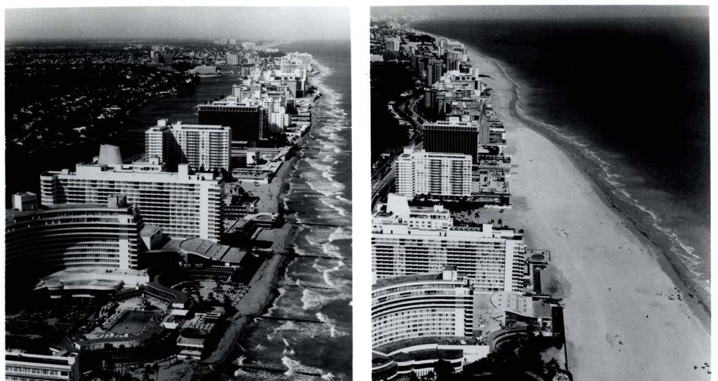
6 Retreat in North Carolina June 2002 The sandbags protect the septic tank. SAP 4.1 Coastal Sensitivity to Sea-level Rise

7 October 2002 SAP 4.1 Coastal Sensitivity to Sea-level Rise

8 June 2003 SAP 4.1 Coastal Sensitivity to Sea-level Rise
9 Chapters 6: Protection and Retreat Three Responses to Coastal Erosion Retreat Hold Back the Sea: Armor the Shore (e.g. dikes) or Replace lost sediments SAP 4.1 Coastal Sensitivity to Sea-level Rise

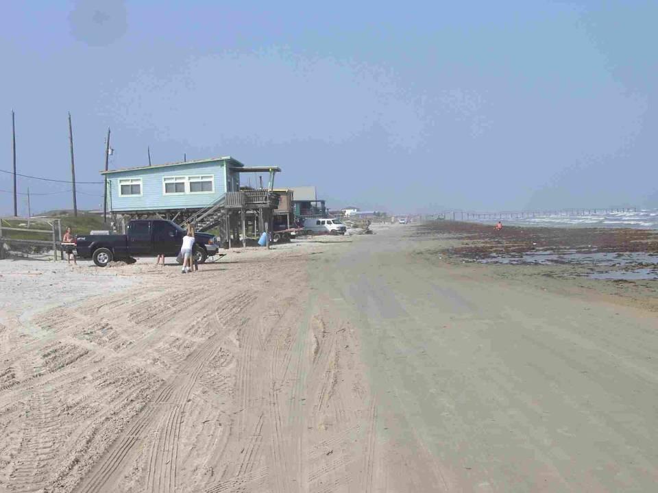
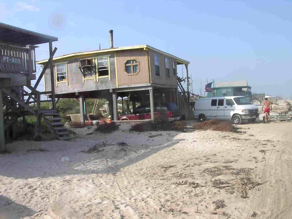
10 Galveston, Texas

11 Near Surfside Texas

12 Bolivar Peninsula, Texas

13 Peconic Estuary, New York
14 Chapters 6: Protection and Retreat Three Responses to Coastal Erosion Retreat Hold Back the Sea: Armor the Shore (e.g. dikes) or Elevate/Replace lost sediments SAP 4.1 Coastal Sensitivity to Sea-level Rise

15 North Beach, Maryland
16


17 Chapters 6: Protection and Retreat Three Responses to Coastal Erosion Retreat Hold Back the Sea: Armor the Shore (e.g. dikes) or Replace lost sediments SAP 4.1 Coastal Sensitivity to Sea-level Rise
18 Initial assessment of long-term response to shore erosion: Atlantic Coast Land use Study assumption: shore protection is* Developed Almost certain 42 % of low land** Development expected Likely 15 Undeveloped Unlikely 33 Conservation land Precluded 9 Source: Titus et al. 2009; Environmental Research Letters. * Assumptions also incorporated site-specific shore protection policies; level of development necessary for shore protection greater along ocean than along estuaries **Percentages do not add up to 100% due to truncation.

19 Caveat: This map is based on land planning data and land use policies, which are continually changing. Map is valid for an overall assessment, not site-specific predictions. Source: Environmental Research Letters
20 Hard to Prepare Unless You Know Which Path You Are On Decision: Dike Elevate Retreat Rebuild drainage systems Replace septics with public sewer Rebuild roads Location of roads Setbacks/ Subdivision Checkvalves, holding tanks, pumps Extending sewer helps drainage Keep roads at same elevation; owners will not have to elevate lots Shore-parallel road needed for dike maintenance Setback from shore to leave room for dike No change needed Mound; extending sewer okay Rebuild road higher, motivate property owners to elevate No change No change Install larger pipes, larger rights of way for ditches Extending sewer undermines policy; mounds system ok Elevate roads to facilitate evacuation Shore parallel road will be lost; all must have access to shoreperpendicular road, Erosion-based setbacks Shoreline Easements Easement or option to purchase land for dike No change Rolling easements to ensure that wetlands and beaches migrate SAP 4.1 Coastal Sensitivity to Sea-level Rise
21 More Institutional Barriers


22
23 Development, Protection, and Moral Hazard Anticipating Sea Level Rise is Logically Justified Sea level rise changes merits of Shore protection Home elevation Coastal development Flood insurance Can ensure that risks are reflected in the cost of coastal habitation key tool for ensuring safe construction (e.g. floor elevation) Institutional Biases: Policies encourage development Local policies Development a route to federal subsidies Federal safety net for development Subsidized shore protection FEMA programs that pay for shore protection, home elevation, relocation Flood Insurance Grandfathering of assumed risk: Sea level rise not included in flood mapping. SAP 4.1 Coastal Sensitivity to Sea-level Rise
24
25 5 th Amendment: nor shall private property be taken for public use, without just compensation
26 Common Law since Roman Empire (Institutes of Justinian) Public Trust Doctrine: Public owns the waters Right to use the shore Law of Accretion and Reliction: Gradual erosion boundaries move New inlet or channel (avulsion): boundaries do not move Storm erosion (avulsion in some states) English common law: doctrine seemed to suggest boundary does not move focus was on King s need to own sudden accretion Florida: Boundary does not move Texas: Boundary moves
27 5 th Amendment: nor shall private property be taken for public use, without just compensation Regulatory taking Physical Invasion
28 Is there a property right to hold back the sea? Regulatory taking: Under Lucas v South Carolina Coastal Council a regulation that totally destroys the property value is a taking unless it merely prohibits something that was never the owner s right to begin with (i.e. preventing a common law nuisance) A fence across an easement is a common law nuisance? Query: How about a seawall that eliminates public beach easement?
29 Which right is superior? Migrating beach or a home in a fixed location? Severance v. Patterson (Texas GLO), 5 th Circuit (We ll skip the 4th amendment seizure issue)
30 Private Public OCEAN BEACH Dune Vegetation Line Dry Beach Wet Beach Open Water Storm MHW MLW BAY SHORE Storm MSHW Transition Wetlands Dry Land Marsh High Marsh Low Mud Flat Open Water MHW MSL MLW MSL = Mean Sea Level MLW = Mean Low Water MHW = Mean High Water MSHW = Mean Spring High Water Storm = Average Annual Storm Tide
31 OCEAN BEACH Dune Vegetation Line Private Rolling Public Easement Public Dry Beach Wet Beach Open Water Storm MHW MLW BAY SHORE Storm MSHW Transition Wetlands Dry Land Marsh High Marsh Low Mud Flat Open Water MHW MSL MLW MSL = Mean Sea Level MLW = Mean Low Water MHW = Mean High Water MSHW = Mean Spring High Water Storm = Average Annual Storm Tide
32
33
34 Which right is superior? Migrating beach or a home in a fixed location? Severance v. Patterson (Texas GLO), 5 th Circuit Certified to Texas Supreme Court: Is rolling easement common law or 40-year old statute? Did common law easement roll only within the first row of lots, or also the next row back? Is aligning property interests with the facts of nature an unconstitutional taking? If the Legislature does it (may arise in Severance ) If a State supreme court it (judicial taking)

35
36 Coming Soon: The judicial taking case: Walton County v. Stop the Beach Renourishment, Inc. Physical Invasion: Florida statute authorizing beach nourishment replaces the old rule of migrating property lines with a fixed property line for those beaches that are nourished Then state seeks to hold the line. But new beaches created seaward of property line are now state-owned Littoral owners lose common law right to accretion: Is that a taking? Florida Supreme Court says no by declaring that common law does not protect possible future accretion. Is it a taking for Florida Supreme Court to clarify the common law in that way?
37 Conclusion Rising sea level likely to shift shores inland by a magnitude unprecedented in the history of civilization We are not prepared Little or no dialogue divergent expectations Existing institutions assume most shores are stable Shore protection and retreat are expensive, complicated, and require a long lead time to minimize social and economic cost Who will lead the way? land owners local government state government federal government
< H 1 >ROLLING EASEMENTS < / H 1 > < H 3 >James G. Titus < / H 3 > June 2011
 < H 1 >ROLLING EASEMENTS < / H 1 > by < H 3 >James G. Titus < / H 3 > June 2011 Titus, J.G. 2011 Rolling Easements. U.S. Environmental Protect ion Agency. Washington, D.C. 1 CHAPTER 1 INTRODUCTION 1.1
by Richard J. McLaughlin Harte Research Institute for Gulf of Mexico Studies
 by Richard J. McLaughlin Harte Research Institute for Gulf of Mexico Studies Historical context of beach access and rolling easements in Texas Quick review of the Open Beaches Act and relevant judicial
Competing Rights to our Natural Resources and Privileges to the Shore March 30, 2016
 Competing Rights to our Natural Resources and Privileges to the Shore March 30, 2016 Prof. Dennis Esposito Director Environmental and Land Use Clinical Externship Program; Adjunct Prof. Marine Affairs
by Richard J. McLaughlin Harte Research Institute for Gulf of Mexico Studies Texas A&M University-Corpus Christi
 by Richard J. McLaughlin Harte Research Institute for Gulf of Mexico Studies Texas A&M University-Corpus Christi Historical context of beach access and rolling easements in Texas Quick review of the Open
A LINE IN THE SAND: BALANCING THE TEXAS OPEN BEACHES ACT AND COASTAL DEVELOPMENT
 A LINE IN THE SAND: BALANCING THE TEXAS OPEN BEACHES ACT AND COASTAL DEVELOPMENT Eddie R. Fisher, Texas General Land Office, Director, Coastal Stewardship Division Angela L. Sunley, Texas General Land
LEGAL AND POLICY IMPLICATIONS OF INNOVATIVE PLANNING FOR SEA-LEVEL RISE IN THE GULF OF MEXICO FINAL REPORT AND RESEARCH SUMMARY JANUARY 2013
 LEGAL AND POLICY IMPLICATIONS OF INNOVATIVE PLANNING FOR SEA-LEVEL RISE IN THE GULF OF MEXICO FINAL REPORT AND RESEARCH SUMMARY JANUARY 2013 MASGP- 13-002 In February 2010, the Mississippi-Alabama Sea
SAND WARS AN OVERVIEW OF CURRENT LEGAL DISPUTES INVOLVING PUBLIC ACCESS ON PRIVATELY OWNED (AND DEVELOPED) DRY SAND BEACHES
 DRY SAND BEACHES") SAND WARS AN OVERVIEW OF CURRENT LEGAL DISPUTES INVOLVING PUBLIC ACCESS ON PRIVATELY OWNED (AND DEVELOPED) DRY SAND BEACHES SEVERANCE V. PATTERSON CHALLENGES TEXAS ROLLING BEACH EASEMENT SYSTEM In Texas,
SAND WARS AN OVERVIEW OF CURRENT LEGAL DISPUTES INVOLVING PUBLIC ACCESS ON PRIVATELY OWNED (AND DEVELOPED) DRY SAND BEACHES SEVERANCE V. PATTERSON CHALLENGES TEXAS ROLLING BEACH EASEMENT SYSTEM In Texas,
Sea-Level Rise and Flooding: Legal, Fiscal, & Regulatory Challenges for Local Governments, Part I
 Sea-Level Rise and Flooding: Legal, Fiscal, & Regulatory Challenges for Local Governments, Part I Click to edit Master title style Click to edit Master subtitle style Thomas Ruppert Coastal Planning Specialist
APPENDIX F REAL ESTATE
 APPENDIX F REAL ESTATE Real Estate Plan For Broward County, Florida Shore Protection Project Segments II and III General Reevaluation Report 1. Statement Of Purpose. The Real Estate Plan is tentative in
Legal Risk Analysis for Sea Level Rise Adaptation Strategies in San Diego EXECUTIVE SUMMARY
 Legal Risk Analysis for Sea Level Rise Adaptation Strategies in San Diego EXECUTIVE SUMMARY Photo Credit: NOAA OVERVIEW PROJECT Adapting to sea rise raises Adapting to sea Environmental Law Institute June
Waterfront Titles in Washington
 Waterfront Titles in Washington WLTA Education Seminar Lynnwood, Washington October 20, 2012 George Peters Disclaimer: When in comes to water and title insurance the operative term is: CYA Control your
3.9. MARYLAND % 11.2% Adaptations Status IncorporaType Impact Standard Costs Funding Source
 C OST E FFICIENT C LIMATE A DAPTATION IN THE N ORTH A TLANTIC 173 3.9.1. OCEAN CITY, MD 3.9. MARYLAND Population Density Form of Government Category 1543/ sq. mi. Town Seasonal Barrier Island CRS Rating
Respecting, Regulating, or Rejecting the Right to Rebuild Post Sandy: What Does the Takings Clause Teach Us?
 Respecting, Regulating, or Rejecting the Right to Rebuild Post Sandy: What Does the Takings Clause Teach Us? Michael Allan Wolf Richard E. Nelson Chair in Local Government Law University of Florida Levin
FLOOD HAZARD AREA LAND USE MANAGEMENT
 FLOOD HAZARD AREA LAND USE MANAGEMENT Introduction Guidance For Selection of Qualified Professionals and Preparation of Flood Hazard Assessment Reports This document is intended to provide guidance for
Water Rights: Beds, Boats & Beaches
 Water Rights: Beds, Boats & Beaches James W. Williams III Chicago Title Insurance Co. 3/16/2005 Chicago Title 1 Introduction Public Trust Doctrine & Submerged Lands Federal Navigational Servitude Who Owns
Planning for Rising Sea Levels: What Planners Need to Know About the Public Trust Doctrine
 Planning for Rising Sea Levels: What Planners Need to Know About the Public Trust Doctrine By: Stuart L. Pratt A Masters Project submitted to the faculty of the University of North Carolina at Chapel Hill
February 29, To: Sarah Absher Senior Planner Tillamook County Department of Community Development
 February 29, 2016 To: Sarah Absher Senior Planner Tillamook County Department of Community Development From: Richard Hook Chair, Neskowin Citizen Advisory Committee Subject: Application 851-15-000265-PLNG:
Local and Federal Funding for Mainland Beach Restoration Projects
 Local and Federal Funding for Mainland Beach Restoration Projects Presented by: Andrew Wycklendt (CB&I) Hawaii Shore and Beach Preservation Association 2014 Beach Restoration Workshop November 24, 2014
EDISTO BEACH COASTAL STORM DAMAGE REDUCTION GENERAL INVESTIGATION STUDY APPENDIX K REAL ESTATE
 EDISTO BEACH COASTAL STORM DAMAGE REDUCTION GENERAL INVESTIGATION STUDY APPENDIX K REAL ESTATE Table of Contents REAL ESTATE APPENDIX... I... i SECTION 1. THE REAL ESTATE REPORT... 1 1.1 Statement of Purpose...
LIFE S A BEACH: OCEANFRONT PROPERTY ISSUES PATRICIA PATTISON DONALD SANDERS I. INTRODUCTION
 LIFE S A BEACH: OCEANFRONT PROPERTY ISSUES PATRICIA PATTISON DONALD SANDERS I. INTRODUCTION The Public Trust Doctrine has caused significant angst for several oceanfront property owners. The Doctrine,
BEACH STORM DAMAGE REDUCTION EASEMENT
 STATE OF FLORIDA COUNTY OF WALTON WALTON COUNTY, FL HURRICANE & STORM DAMAGE REDUCTION PROJECT FILE/REACH#: PARCEL ID#: BEACH STORM DAMAGE REDUCTION EASEMENT KNOW ALL MEN BY THESE PRESENTS, that for and
ARLINGTON COUNTY, VIRGINIA. County Board Agenda Item Meeting of June 17, 2017
 ARLINGTON COUNTY, VIRGINIA County Board Agenda Item Meeting of June 17, 2017 DATE: June 9, 2017 SUBJECT: Request to authorize advertisement of public hearings by the Planning Commission and County Board
Copyright Maryland Law Review, Inc Articles
 MARYLAND LAW REVIEW VOLUME 57 1998 NUMBER 4 Copyright Maryland Law Review, Inc. 1998 Articles RISING SEAS, COASTAL EROSION, AND THE TAKINGS CLAUSE: HOW TO SAVE WETLANDS AND BEACHES WITHOUT HURTING PROPERTY
V. Economic Assessment
 V. Economic Assessment A. Overview of Economic Considerations The potential economic impact to State and local governments, and the private sector from erosion due to shifting inlets was assessed. Using
CHARLES CITY COUNTY SITE PLAN ORDINANCE. This Ordinance shall be known as the Charles City County Site Plan Ordinance.
 CHARLES CITY COUNTY SITE PLAN ORDINANCE Section 1. Title This Ordinance shall be known as the Charles City County Site Plan Ordinance. Section 2. Authority. This Ordinance is enacted pursuant to the authority
Adapting to Climate Change on the Oregon Coast: Lines in the Sand and Rolling Easements
 COURTNEY B. JOHNSON AND STEVEN R. SCHELL Adapting to Climate Change on the Oregon Coast: Lines in the Sand and Rolling Easements Introduction... 449 I. A Short History of Property Boundaries and Rights
FLOOD-RESISTANT CONSTRUCTION
 FLOOD-RESISTANT CONSTRUCTION The provisions contained in this appendix are not mandatory unless specifically referenced in the adopting ordinance. SECTION G101 ADMINISTRATION G101.1 Purpose. The purpose
APPENDIX D REAL ESTATE PLAN
 APPENDIX D REAL ESTATE PLAN APPENDIX D REAL ESTATE PLAN TABLE OF CONTENTS 1. STATEMENT OF PURPOSE 2. REFERENCES 3. AUTHORIZATION 4. BACKGROUND 5. LOCATION 6. REAL ESTATE REQUIREMENTS 7. OWNERSHIP OF REAL
Resource Protection Area Map Update - Frequently Asked Questions
 DEPARTMENT OF ENVIRONMENTAL SERVICES Office of Sustainability and Environmental Management 2100 Clarendon Boulevard, Suite 705, Arlington, VA 22201 TEL 703-228-4488 FAX 703-228-7134 TTY 703-228-4611 www.arlingtonva.us
Walton County Planning and Development Services
 Walton County Planning and Development Services 31 Coastal Centre Boulevard, Suite 100 47 N 6 th Street Santa Rosa Beach, Florida 32459 DeFuniak Springs, Florida 32433 Phone 850-267-1955 Phone 850-892-8157
M E M O R A N D U M Florida Legislative Session Bills of Concern CS/HB 631 (Chapter Law ) Customary Use and Beach Access
 Customary Use and Beach Access") THOMAS J. TRASK, B.C.S.* JAY DAIGNEAULT RANDY MORA ERICA F. AUGELLO JOHN E. SCHAEFER DAVID E. PLATTE PATRICK E. PEREZ ROBERT M. ESCHENFELDER, B.C.S.* * Board Certified by the Florida Bar in City, County
THOMAS J. TRASK, B.C.S.* JAY DAIGNEAULT RANDY MORA ERICA F. AUGELLO JOHN E. SCHAEFER DAVID E. PLATTE PATRICK E. PEREZ ROBERT M. ESCHENFELDER, B.C.S.* * Board Certified by the Florida Bar in City, County
Marine Turtle Protection Act. Allows designation of Aquatic Preserves. Protects sea turtle nesting habitat (1953)
") , STATE AND LOCAL AUTHORITY FOR MARINE PROTECTION (2014). FLORIDA 1 State Authority for Marine Protection Summary of State Authorities Florida has a number of statutes that grant state agencies authority
, STATE AND LOCAL AUTHORITY FOR MARINE PROTECTION (2014). FLORIDA 1 State Authority for Marine Protection Summary of State Authorities Florida has a number of statutes that grant state agencies authority
ENVIRONMENTAL AND RESOURCE PROTECTION
 CHAPTER THREE ENVIRONMENTAL AND RESOURCE PROTECTION Page 3.00.00 GENERALLY 3-3 3.00.01 Purpose and Intent 3-3 3.00.02 Applicability 3-3 3.01.00 ENVIRONMENTALLY SENSITIVE LANDS AND HABITATS 3-3 3.01.01
APPLICATION PROCEDURE
 ANTRIM PLANNING BOARD P. O. Box 517 Antrim, New Hampshire 03440 Phone: 603-588-6785 FAX: 603-588-2969 APPLICATION FORM AND CHECKLIST FOR EARTH EXCAVATION AND RECLAMATION File # Date Received By APPLICATION
Mitigating Myopia: Climate Change, Rolling Easements, and the Jersey Shore
 Seton Hall University erepository @ Seton Hall Law School Student Scholarship Seton Hall Law 2014 Mitigating Myopia: Climate Change, Rolling Easements, and the Jersey Shore Kevin J. Mahoney Follow this
Local units of government control the use of private
 9 Land Use REEB 24.085 Chapter Overview Land use issues are one of the hottest topics in the area of real estate. This chapter outlines the basics of land use regulation. Important Terminology conditional
ORDINANCE NO WHEREAS, the Town of Jupiter ( Town ) has adopted a Comprehensive Plan
 has adopted a Comprehensive Plan") 0 0 ORDINANCE NO. -0 AN ORDINANCE OF THE TOWN COUNCIL OF THE TOWN OF JUPITER, FLORIDA, AMENDING CHAPTER OF THE TOWN CODE TO AMEND SECTION -, ENTITLED INTENT TO ADD PERMITTING LANDGUAGE; TO AMEND SECTION
0 0 ORDINANCE NO. -0 AN ORDINANCE OF THE TOWN COUNCIL OF THE TOWN OF JUPITER, FLORIDA, AMENDING CHAPTER OF THE TOWN CODE TO AMEND SECTION -, ENTITLED INTENT TO ADD PERMITTING LANDGUAGE; TO AMEND SECTION
Alfred J. Malefatto & Keri Ann C. Baker Lewis, Longman & Walker, P.A. Tyler Chappell The Chappell Group, Inc.
 Alfred J. Malefatto & Keri Ann C. Baker Lewis, Longman & Walker, P.A. Tyler Chappell The Chappell Group, Inc. Coastal construction activities are regulated by the State to prevent imprudent construction
DISTRICT OF NORTH SAANICH B Y L A W N O A BYLAW TO MITIGATE COASTAL FLOODING HAZARDS
 DISTRICT OF NORTH SAANICH B Y L A W N O. 1439 A BYLAW TO MITIGATE COASTAL FLOODING HAZARDS WHEREAS: A. If a flood plain has been designated in a District bylaw, the Local Government Act requires that the
City of Mexico Beach Planning & Zoning Board Regular Meeting Monday, October 30, 2017 Public Workshop 12:30 P.M. Civic Center 105 N.
 City of Mexico Beach Planning & Zoning Board Regular Meeting Monday, October 30, 2017 Public Workshop 12:30 P.M. Civic Center 105 N. 31 st Street Post 1 Don Coakley Alternate Post 1 James Hogan Post 2
TAKINGS LAW UNDER THE U.S. AND CONNECTICUT CONSTITUTIONS
 TAKINGS LAW UNDER THE U.S. AND CONNECTICUT CONSTITUTIONS 2 0 1 5 C L I M AT E A D A P TAT I O N A C A D E M Y J O H N P. C A S E Y, E S Q. Boston Hartford New York Providence Stamford Albany Los Angeles
CITY OF FORT COLLINS NATURAL AREAS AND CONSERVED LANDS EASEMENT POLICY
 CITY OF FORT COLLINS NATURAL AREAS AND CONSERVED LANDS EASEMENT POLICY Adopted January 3, 2012 PURPOSE: The purpose of the policy statement is to clarify the policies and procedures of the City of Fort
FIGURE EIGHT ISLAND HOMEOWNERS ASSOCIATION, INC. Case Study
 FIGURE EIGHT ISLAND HOMEOWNERS ASSOCIATION, INC. Case Study by Howard O. Rockness Professor of Accounting University of North Carolina Wilmington Joanne W. Rockness Camerson Professor of Accounting University
IN THE SUPREME COURT OF FLORIDA.? SC First DCA Case No.: 1D
 IN THE SUPREME COURT OF FLORIDA? --------------- SC-06-1449 First DCA Case No.: 1D05-4086? --------------- FLORIDA DEPARTMENT OF ENVIRONMENTAL PROTECTION and THE BOARD OF TRUSTEES OF THE INTERNAL IMPROVEMENT
Journal of Environmental and Sustainability Law
 Journal of Environmental and Sustainability Law Missouri Environmental Law and Policy Review Volume 18 Issue 2 Spring 2011 Article 8 2011 Stop the Beach Renourishment: Why Judicial Takings May Have Meant
A COST-BENEFIT APPROACH TO COASTAL ADAPTATION
 A COST-BENEFIT APPROACH TO COASTAL ADAPTATION New Orleans June 15, 2015 By: The Balmoral Group Craig Diamond Outline 2 Micro-Introduction to The Balmoral Group Project Background -- Context Project Objectives
Coastal Shore Jurisdiction in British Columbia
 ISSUE SHEET October 2009 Coastal Shore Jurisdiction in British Columbia Ju ris dic tion: the power, right and authority to interpret and apply the law. (Merriam Webster on-line) Who s in charge of coastal
SANTA BARBARA COUNTY ZONING ADMINISTRATOR Staff Report for Coleman SFD Addition Coastal Development Permit with Hearing
 SANTA BARBARA COUNTY ZONING ADMINISTRATOR Staff Report for Coleman SFD Addition Coastal Development Permit with Hearing Supervisorial District: First Staff Report Date: August 10, 2005 Staff: Lisa Hosale
Severance v. Patterson: How Do Property Rights Move When the Dynamic Sea Meets the Static Shore?
 Ecology Law Quarterly Volume 40 Issue 2 Article 5 3-1-2013 Severance v. Patterson: How Do Property Rights Move When the Dynamic Sea Meets the Static Shore? Gwynne Hunter Follow this and additional works
Directions For Filling Out A CAMA MINOR Permit
 Directions For Filling Out A CAMA MINOR Permit Please fill out the application completely including applicant's signature on the second page. Be sure to complete the "statement of ownership" and the "adjacent
EXCERPTS FROM HALIFAX REGIONAL MUNICIPALITY CHARTER
 EXCERPTS FROM HALIFAX REGIONAL MUNICIPALITY CHARTER Municipal planning strategy 227 The Council may adopt a municipal planning strategy for all, or part, of the Municipality and there may be separate strategies
No In the SUPREME COURT OF THE UNITED STATES
 No. 08-1151 -------------------------------- In the SUPREME COURT OF THE UNITED STATES ------------------------------- STOP THE BEACH RENOURISHMENT, INC., v. Petitioner, FLORIDA DEPARTMENT OF ENVIRONMENTAL
Pinellas County Shore Protection Project. May 03, 2017 Sand Key Project Information Meeting
 Pinellas County Shore Protection Project May 03, 2017 Sand Key Project Information Meeting Meeting Outline Project Overview Why Nourish the Beach? Where Are The Easements Located? Key Easement Provisions
Ensures that all perennial streams and connected wetland are identified and protected for projects that disturb more than 2,500 sf of land.
 Page 1 of 22 A. MAP ISSUES 1. How should the Resource Protection Area (RPA) be mapped? The draft Chesapeake Bay Preservation Area Map ( the Map ) is general in nature and is not intended to depict the
Meeting Notes GOTO MEETING VIDEO CONFERENCE
 Meeting Notes Public Meeting at Pinellas County Extension 12520 Ulmerton Road, Largo, FL Topic: Easements for 2017 Sand Key Nourishment Project May 3, 2017, 6 7:30 pm Pinellas County Staff Present: Andy
A Fiscal Analysis of Shifting Inlets and Terminal Groins in North Carolina
 Attachment 1 A Fiscal Analysis of Shifting Inlets and Terminal Groins in North Carolina Andrew S. Coburn, Associate Director Program for the Study of Developed Shorelines Western Carolina University 294
CHAPTER 6 CHESAPEAKE BAY PRESERVATION AREAS AND STREAM PROTECTION AREAS
 CHAPTER 6 CHESAPEAKE BAY PRESERVATION AREAS AND STREAM PROTECTION AREAS 6.1 INTRODUCTION Virginia s Chesapeake Bay Preservation Area (CBPA) Designation and Management Regulations (9VAC10-20 et seq.) require
CHARLOTTE COUNTY, FLORIDA MANASOTA KEY BEACH RENOURISHMENT PROJECT INITIAL ASSESSMENT RESOLUTION RESOLUTION NUMBER 18-
 CHARLOTTE COUNTY, FLORIDA MANASOTA KEY BEACH RENOURISHMENT PROJECT INITIAL ASSESSMENT RESOLUTION RESOLUTION NUMBER 18- ADOPTED, 2018 TABLE OF CONTENTS Page ARTICLE I DEFINITIONS AND CONSTRUCTION SECTION
TOWNSHIP OF EGG HARBOR ZONING BOARD ADJUSTMENT CHECK LIST
 TOWNSHIP OF EGG HARBOR ZONING BOARD ADJUSTMENT CHECK LIST Schedule A - General Requirements 1. Where the application involves only a variance one (1) original and nineteen (19) copies of the appropriate
APPENDIX H. Real Estate Plan
 INTEGRATED FEASIBILITY REPORT AND ENVIRONMENTAL IMPACT STATEMENT COASTAL STORM DAMAGE REDUCTION BOGUE BANKS, CARTERET COUNTY NORTH CAROLINA APPENDIX H Real Estate Plan US Army Corps of Engineers Wilmington
Town of Surf City. City Council Presentation April 2, 2013 PETER A. RAVELLA, PRINCIPAL PAR CONSULTING, LLC
 Town of Surf City City Council Presentation April 2, 2013 PETER A. RAVELLA, PRINCIPAL CONSULTING, LLC I. Review Workshop schedule & Input SC-NTB Federal Project Plan 1550 Funding Contributors You re Not
Dynamic Property Rights: The Public Trust Doctrine and Takings in a Changing Climate
 Dynamic Property Rights: The Public Trust Doctrine and Takings in a Changing Climate Margaret E. Peloso * & Margaret R. Caldwell ** I. INTRODUCTION... 53 A. The Public Trust Doctrine and Rolling Easements...
Applicant s Agent Lisa Murphy, Esq. Staff Planner PJ Scully. Lot Recordation 12/01/1972 Map Book 94, Page 33 GPIN
 Property Owner and Applicant Address 3925 Shore Drive Public Hearing September 24, 2018 City Council District Bayside Agenda Item 6 Variance Request Encroachment into the Resource Protection Area (RPA)
IRS FORM 8283 SUPPLEMENTAL STATEMENT DONATION OF CONSERVATION EASEMENT
 Name(s) shown on income tax return Identifying Number Robert T. Landowner 021-34-1234 Susan B. Landowner 083-23-5555 IRS FORM 8283 SUPPLEMENTAL STATEMENT DONATION OF CONSERVATION EASEMENT On November 12,
ZONING AMENDMENT STAFF REPORT Date: September 15, 2016
 ZONING AMENDMENT STAFF REPORT Date: September 15, 2016 NAME LOCATION Clear Water, LLC 3490 Hurricane Bay Road (Northeast corner of Hurricane Bay Road and Hurricane Bay Lane) CITY COUNCIL DISTRICT District
ORDINANCE NO _
 ORDINANCE NO. 2016-00_ Board of Commissioners Town of Topsail Beach, North Carolina Date: AN ORDINANCE OF THE BOARD OF COMMISSIONERS OF THE TOWN OF TOPSAIL BEACH, NORTH CAROLINA THAT (1) AMENDS DIVISION
Subdivision - Application
 Planning and Development Services, 2001 Sherwood Drive, Sherwood Park, AB T8A 3W7 Phone 780-464-8080 Fax 780-464-8109 Email: Landuse&policyplanning@strathcona.ca (Page 1 of 5) This form is to be completed
Regulatory Takings and Property Rights Confront Sea Level Rise: How Do They Roll?
 Pace University DigitalCommons@Pace Pace Law Faculty Publications School of Law 2012 Regulatory Takings and Property Rights Confront Sea Level Rise: How Do They Roll? John R. Nolon Elisabeth Haub School
F R E QUENTLY AS K E D QUESTIONS
 F R E QUENTLY AS K E D QUESTIONS Mountain Home Substation and 138-kV Transmission Line Project Gillespie, Kerr and Kimble counties PROJECT OVERVIEW 1. What is the Mountain Home Substation and 138-kV Transmission
Built Seawalls: A Protected Investment Or Subordinate To The Public Interest
 Ocean and Coastal Law Journal Volume 18 Number 1 Article 11 2012 Built Seawalls: A Protected Investment Or Subordinate To The Public Interest Sorell E. Negro Follow this and additional works at: http://digitalcommons.mainelaw.maine.edu/oclj
SURVEYING BOUNDARIES FORESHORE AND PROPERTY OUTLINE DEFINITIONS JURISDICTIONAL ISSUES TENURE ISSUES PRACTICAL SURVEY ISSUES RECOMMENDATIONS
 SURVEYING BOUNDARIES OUTLINE DEFINITIONS JURISDICTIONAL ISSUES TENURE ISSUES PRACTICAL SURVEY ISSUES RECOMMENDATIONS DEFINITIONS FORESHORE: the part of the seashore between the high water mark and the
Safe Waterfront Access, PID Council Report -2 - May 10, 2016 BACKGROUND
 14.3.1 Safe Waterfront Access, PID 00560789 Council Report -2 - May 10, 2016 BACKGROUND A staff information report dated April 11, 2016 regarding safe waterfront access at PID 00560789 was before the Halifax
Robert Armstrong, Director, Development & Environmental Services
 Date Monday, November 09, 2015 From Robert Armstrong, Director, Development & Environmental Services Subject Oak Meadows Site Plan Approval and Agreement Report No. PB2015-53 Roll No. 42-10-493-001-09500
IN THE SUPREME COURT OF FLORIDA
 IN THE SUPREME COURT OF FLORIDA FLORIDA DEPARTMENT OF ENVIRONMENTAL PROTECTION, Appellants, vs. SAVE OUR BEACHES, INC., et al., CASE NUMBER: SC06-1449 Appellees. / AMICUS CURIAE BRIEF OF FLORIDA SHORE
Florida Department of Environmental Protection Florida s State Lands Authorizations
 Florida Department of Environmental Protection Florida s State Lands Authorizations Andrew J. Baumann, Esq. Kelly Samek, Senior Assistant General Counsel Sovereign Submerged Lands Lands under navigable
Special Use Permit - Planned Unit Development Checklist. Property Address:
 Special Use Permit - Planned Unit Development Checklist Special Use Permit Number. Parcel Code/s #28-11- - - Property Address: Applicant: ARTICLE VIII Ordinance Reference - Section 8.1.2 Permit Procedures:
ORDINANCE NO
 ORDINANCE NO. 2017-09 AN ORDINANCE OF THE CITY COMMISSION OF THE CITY OF ST. AUGUSTINE, FL AMENDING THE CITY OF ST. AUGUSTINE CODE OF ORDINANCES AMENDING CHAPTER 8, ARTICLE V FLOODPLAIN MANAGEMENT AND
610 LAND DIVISIONS AND PROPERTY LINE ADJUSTMENTS OUTSIDE A UGB
 ARTICLE VI: LAND DIVISIONS AND PROPERTY LINE ADJUSTMENTS VI-21 610 LAND DIVISIONS AND PROPERTY LINE ADJUSTMENTS OUTSIDE A UGB 610-1 Property Line Adjustments (Property Line Relocation) A property line
Supreme Court of Florida
 Supreme Court of Florida No. SC06-1447 WALTON COUNTY, et al., Petitioners, vs. STOP THE BEACH RENOURISHMENT, INC., et al., Respondents. No. SC06-1449 FLORIDA DEPARTMENT OF ENVIRONMENTAL PROTECTION, etc.,
The Price of Protection: Compensation for Partial Takings along the Coast
 Touro Law Review Volume 30 Number 3 Article 16 October 2014 The Price of Protection: Compensation for Partial Takings along the Coast Matthew Hromadka Follow this and additional works at: http://digitalcommons.tourolaw.edu/lawreview
JANUARY 13, 2006-SPECIAL MEETING. The Board of County Commissioners, Walton County, Florida, held a
 JANUARY 13, 2006-SPECIAL MEETING The Board of County Commissioners, Walton County, Florida, held a Comprehensive Plan Evaluation and Appraisal Report Priority Issue Scoping Meeting on Friday, January 13,
PROTECTING WATER RESOURCES AFTER MURR v. WISCONSIN
 PROTECTING WATER RESOURCES AFTER MURR v. WISCONSIN American Planning Association Water & Planning Connect Plans, Codes, and Water September 11, 2018 Mark White White & Smith, LLC www.planningandlaw.com
Emergency Watershed Program Sandy Recovery Activities and Flood Plain Easement Program
 Emergency Watershed Program Sandy Recovery Activities and Flood Plain Easement Program Greg Westfall, Resource Conservationist USDA-Natural Resources Conservation Service (NRCS) Set up by Congress to respond
WASCO COUNTY PRELIMINARY SUBDIVISION APPLICATION
 WASCO COUNTY PRELIMINARY SUBDIVISION APPLICATION DETAILED SPECIFIC WRITTEN REQUEST File Number: SDV- Number of Proposed Lots & their Dimensions: PRELIMINARY SUBDIVISION PLAN REQUIREMENTS The approval of
TOWN OF MELBOURNE BEACH 2016 DEVELOPMENT APPLICATION
 TOWN OF MELBOURNE BEACH 2016 DEVELOPMENT APPLICATION I. SUBMITTAL REQUIREMENTS: 1. Fees per current schedule. 2. Deed to property. 3. Pre-Application meeting is mandatory. Contact the Building Official
FUTURE LAND USE. City of St. Augustine Comprehensive Plan EAR-Based Amendments
 FUTURE LAND USE City of St. Augustine Comprehensive Plan EAR-Based Amendments Future Land Use Element FLU Goal To create an environment within the City and adjacent areas in which its residents have the
NOTICE OF LAND USE DECISION BY THE COOS COUNTY PLANNING DIRECTOR
 NOTICE OF LAND USE DECISION BY THE COOS COUNTY PLANNING DIRECTOR Coos County Planning 225 N. Adams St. Coquille, OR 97423 http://www.co.coos.or.us/ Phone: 541-396-7770 Fax: 541-396-1022 This notice is
Final General Reevaluation Report and Final Environmental Impact Statement. Hurricane Protection and Beach Erosion Control
 Final General Reevaluation Report and Final Environmental Impact Statement on Hurricane Protection and Beach Erosion Control WEST ONSLOW BEACH AND NEW RIVER INLET (TOPSAIL BEACH), NORTH CAROLINA Appendix
Appendix F. Real Estate
 Appendix F Real Estate U.S. Army Corps of Engineers Galveston District Southwestern Division Appendix F Real Estate Plan for Coastal Texas Protection and Restoration Study Integrated Feasibility Report
STAFF REPORT. Arthur and Kathleen Quiggle 4(b)
") STAFF REPORT Application: Requests related to the construction of a 28' x 41' dwelling and 6' wrap-around open deck to replace an existing 24' x 32' cabin and wrap-around open deck and the installation
STAFF REPORT Application: Requests related to the construction of a 28' x 41' dwelling and 6' wrap-around open deck to replace an existing 24' x 32' cabin and wrap-around open deck and the installation
Can They Build That Here? Tanglewood Neighborhood Association by the Planning and Development Department
 Can They Build That Here? Tanglewood Neighborhood Association by the Planning and Development Department April 16, 2012 Tanglewood Neighborhood Association Includes several platted subdivisions: Tanglewood
ORDINANCE NO. 13-_2_2
 ORDINANCE NO. 13-_2_2 AN ORDINANCE BY THE BOARD OF COUNTY COMMISSIONERS AMENDING THE BAY COUNTY CODE OF ORDINANCES TO REPEAL CHAPTER 9 DRAINAGE, ARTICLE II, FLOODPLAINS; TO ADOPT A NEW CHAPTER 9 DRAINAGE,
SENATE, No STATE OF NEW JERSEY. 217th LEGISLATURE INTRODUCED SEPTEMBER 8, 2016
 SENATE, No. 0 STATE OF NEW JERSEY th LEGISLATURE INTRODUCED SEPTEMBER, 0 Sponsored by: Senator BOB SMITH District (Middlesex and Somerset) Senator CHRISTOPHER "KIP" BATEMAN District (Hunterdon, Mercer,
Buying Property in the San Juans
 1. Select an Agent to Represent You Buying Property in the San Juans As you may be aware, all of the brokerage firms on San Juan Island are members of the Northwest Multiple Listing Service; therefore,
Residential Project Convenience Facilities
 Standards for Specific Land Uses 35.42.220 E. Findings. The review authority shall approve a Land Use Permit in compliance with Subsection 35.82.110.E (Findings required for approval) or a Conditional
RPPTL White Paper on Proposed Beach Access Legislation CS/HB 527
 I. SUMMARY RPPTL White Paper on Proposed Beach Access Legislation CS/HB 527 The Section supports substantial revision to proposed legislation (CS/HB 527/SB 488) or any similar or companion bills or legislation
Fiscal Analysis. Amendments to 15A NCAC 7H.0306 General Use Standards for Ocean Hazard Areas
 Fiscal Analysis Amendments to 15A NCAC 7H.0306 General Use Standards for Ocean Hazard Areas Replacement of Commercial and Multi-Family Residential Structures on the Oceanfront Prepared by Tancred Miller
California Land Surveyors Association
 1 California Land Surveyors Association 2 Introduction 2012 LS REVIEW Water Boundaries March 27, 2012 What are boundaries is a matter of law; where they are is a matter of fact Justice Wheeler, 1856 Today
RULES, REGULATIONS AND REQUIREMENTS RELATING TO THE APPROVAL AND ACCEPTANCE OF IMPROVEMENTS IN SUBDIVISIONS OR RE-SUBDIVISIONS
 GALVESTON COUNTY RULES, REGULATIONS AND REQUIREMENTS RELATING TO THE APPROVAL AND ACCEPTANCE OF IMPROVEMENTS IN SUBDIVISIONS OR RE-SUBDIVISIONS GALVESTON COUNTY ENGINEERING DEPARTMENT MARCH 3, 1997 Amendment
Article 5. Environmentally Sensitive Areas
 Article 5. Environmentally Sensitive Areas This Article establishes standards and regulations governing environmental constraints. These regulations are intended to encourage preservation of lands designated