Geo-information for Disaster Management: 9/11 Lessons & Developments Since
|
|
|
- Christine Burke
- 5 years ago
- Views:
Transcription
1 Geo-information for Disaster Management: 9/11 Lessons & Developments Since Michael J. Kevany Senior Vice President PlanGraphics, Inc.
2 Introduction World Trade Center perspective on Geoinformation in Disaster Management Describe key role of Geo-information in 9/11 response Explore lessons learned Review activities and developments since 9/11/01
3 Background Location most critical element in disaster management & response Geo-information/GIS is the location based technology Value of GIS proven in World Trade Center response & many other emergencies More than making maps Design based on both technology & emergency operations
4 World Trade Center Attack

5
6 The 9/11 Event OEM GIS Emergency Plan Re-establish EOC following destruction of original Employ NYC GIS Utility data resources Provided wide range of geo-information to Mayor, emergency responders & the public Employed numerous geo-information technologies
7 Lessons from the World Trade Center General Lessons Operational Lessons Organizational Lessons Data Lessons Technical Lessons Customer Lessons Logistical Lessons
8 Highlights of Lessons Life & death urgency Immediate decisions Products available & useful in the field Build in flexibility Support real-time operations Provide back-up and redundancy
9 Highlights of Lessons Preparation is critical Include technology in emergency plans & operations Database of general, emergency & event data Use location to integrate varied data sources Establish logistical support procedures for all locations & levels of users
10 Highlights of Lessons Provide for direct use by emergency personnel-tools, training, procedures Provide 24 hour support Design products to support emergency operations specifically Recognize range of requirements & capabilities of customers Incorporate new technologies prior to event
11 Solutions Developed from 9/11 Lessons Methodologies & Business Processes Interoperability & the Information Access Portal Mobile Computing Disaster Management Geo-Information Applications Disaster Management Geo-Information Data Solutions
12 Interoperability/Portal Unified access to a variety of data sources Visualized through single portal Meta data mechanisms for navigation Access non-gis systems & data Easily used by non-expert Web-based technology
13
14
15
16
17
18 Mobile Computing Provide Geo-information data & capabilities in the field Wireless & download Deliver & collect data where practical Recognize field demands on devices Recognize communications vulnerabilities
19 Disaster Management Geo- Information Applications Definition of emergency impact areas to support resource allocation, evacuation planning, and decision-making Support for disaster management resource allocation and logistics Emergency routing Damage assessment Transportation network status tracking Forecast evolving disaster situation
20 Disaster Management Geo- Information Applications Emergency planning Debris management Plume modeling Secure Web site for the exchange of geoinformation among participating units in a disaster response Public emergency information Web site Support for emergency warning notification system
21 Disaster Management Geo- Information Data Solutions General-purpose GIS and related tabular data Disaster management-specific data Real-time spatial data generated and acquired during disaster operations
22 Concluding Recommendations Be prepared Disaster personnel must be involved in the design of technology solutions Technology must be imbedded in emergency operating procedures Disaster personnel must be trained in operation & use of technology & products Procedures employing technology must be tested
23 Sharing Information & Experiences Participation in numerous Homeland Security activities Sharing information in meetings & conferences Cooperative Agreement with Netherlands Council for Geo Information (RAVI)
The Added Value of Geospatial Information in Disaster and Risk Management: A Case Study on the 2009 Flooding in Namibia
 The Added Value of Geospatial Information in Disaster and Risk Management: A Case Study on the 2009 Flooding in Namibia Summary Tessa Anne Belinfante, M.Sc. VU University Amsterdam Objective and Approach
Institutional Arrangements In Geoinformation: Influence of Legal and Policy Issues **
 ADVANCE UNEDITED VERSION UNITED NATIONS E/CONF.103/24 ECONOMIC AND SOCIAL COUNCIL Tenth United Nations Regional Cartographic Conference for the Americas New York, 19-23, August 2013 Item 6 (a) of the provisional
Challenges for the multi purpose cadastre
 Jens RIECKEN, Markus SEIFERT, Germany Key words: Multi purpose cadastre, 3d-cadastre, land use, SDI, solar cadastre SUMMARY Over the past 30 years, with the progress of information technologies the development
What s Next for Commercial Real Estate Leveraging Technology and Local Analytics to Grow Your Commercial Real Estate Business
 What s Next for Commercial Real Estate Leveraging Technology and Local Analytics to Grow Your Commercial Real Estate Business - A PUBLICATION OF GROWTH MAPS- TABLE OF CONTENTS Intro 1 2 What Does Local
Egyptian Nationwide Title Cadastre System
 Kholoud SAAD, Egypt Key words: Cadastre, Registration, Urban, Rural, National Cadastre, Automation, reengineering. SUMMARY With growing need for integrated information, Enterprise Solutions has become
CONCEPT NOTE EFFECTIVE LAND ADMINISTRATION IN AFRICA TRAINING WORKSHOP
 CONCEPT NOTE EFFECTIVE LAND ADMINISTRATION IN AFRICA TRAINING WORKSHOP Innovative Concepts, Tools and Practices for Effective Land Administration Land Conference Pre-Conference Workshop Advocating & Implementing
The Strategic Plan can be viewed by clicking this link.
 What is the purpose of the Land Information Office? Many of Brown County's most basic services rely on accurate and up-to-date land information. Emergency response, resource conservation, infrastructure
Modernizing Land Administration Systems
 Presented at the FIG Congress 2018, May 6-11, 2018 in Istanbul, Turkey Modernizing Land Administration Systems B r e n t J o n e s P E, PLS E s r i Land Administration Systems GIS is the Technology Platform
REGIONAL GEOINFORMATION ENVIRONMENT REGIA
 REGIONAL GEOINFORMATION ENVIRONMENT REGIA Eglė Rimkienė Deputy Chief of Address Register Data Administration Division, State Enterprise Centre of Registers E-mail: Egle.Rimkiene@registrucentras.lt REGIONAL
New Technology for Cadastral Systems. Brent Jones, PE, PLS
 New Technology for Cadastral Systems Brent Jones, PE, PLS Benefits of Good Land Administration Key to addressing global challenges.. Secure Tenure Equitable Land and Property Taxation Support for Government
Innovations in Education at Faculty ITC and within Land Administration Programme
 Innovations in Education at Faculty ITC and within Land Administration Programme Prof. Jaap Zevenbergen, Vice-Dean Education at Faculty ITC, Prof. Land Administration dr. Dimo Todorovski, Course Coordinator
Universal Geo-database Connector Interface Component (UG-CIC) For Virtual Web-base GIS Server Essential For Real Estate Industry Uses
 For Virtual Web-base GIS Server Essential For Real Estate Industry Uses") Universal Geo-database Connector Interface Component (UG-CIC) For Virtual Web-base GIS Server Essential For Real Estate Industry Uses Jad Jarroush & Dr. Kobi Zaid Zaid Orniv Group L.T.D Israel kobi_z@zaidorniv.co.il
Universal Geo-database Connector Interface Component (UG-CIC) For Virtual Web-base GIS Server Essential For Real Estate Industry Uses Jad Jarroush & Dr. Kobi Zaid Zaid Orniv Group L.T.D Israel kobi_z@zaidorniv.co.il
LRIMS Cadastre Module
 LRIMS Cadastre Module User Requirements and Functionality (Seychelles Case Study) John Latham, NRL Renato Cumani, NRL Luigi Simeone, NRL Summary Background User Requirements Business Model Application
NCC Group plc. Preliminary Annual Results for the year ended 31 May 2009
 NCC Group plc Preliminary Annual Results for the year ended 31 May 2009 July 2009 AGENDA Agenda Highlights Track record Group structure Group financials Group strategy Group sector concentrations Group
Learning from land suitability analysis and Dutch spatial policy for sustainable land use in Japan
 Learning from land suitability analysis and Dutch spatial policy for sustainable land use in Japan Toru Nagayama 22 January 2009 GIS Research Group Seminar, University of Tsukuba Highlights from : Nagayama.,
Welcome at the First International Symposium on Geo-information for Disaster Management (Gi4DM)
") Welcome at the First International Symposium on Geo-information for Disaster Management (Gi4DM) by prof. Jacob Fokkema, Rector of the Delft University of Technology April 25, 2005 1 Vermelding onderdeel
Welcome at the First International Symposium on Geo-information for Disaster Management (Gi4DM) by prof. Jacob Fokkema, Rector of the Delft University of Technology April 25, 2005 1 Vermelding onderdeel
A Review and Perspective on Parcel Data Models for Urban Planning
 A Review and Perspective on Parcel Data Models for Urban Planning Yiqiang Ouyang Prof. Dr. Ilir Bejleri Department of Urban and Regional Planning University of Florida June 19-21, 2010 1 Content 1. Introduction
Application of tsunami modelling for escape and refuge planning in Aceh (Indonesia)
") Application of tsunami modelling for escape and refuge planning in Aceh (Indonesia) Odelinde Nieuwenhuis, DHV BV Deepak Vatvani, Deltares (Delft Hydraulics) Jeroen Alberts, DHV BV Dick Jansen, DHV BV May
Application of tsunami modelling for escape and refuge planning in Aceh (Indonesia) Odelinde Nieuwenhuis, DHV BV Deepak Vatvani, Deltares (Delft Hydraulics) Jeroen Alberts, DHV BV Dick Jansen, DHV BV May
Field surveying inspection using tablets
 Field surveying inspection using tablets Rami Farraj, Ahmad Sghyyer Survey of Israel, Lincoln 1, Tel-Aviv, Israel rami@mapi.gov.il ahmad@mapi.gov.il Key words: Field Surveying, Cadastre, Mapping Procedures
Participants of the Ministerial Meeting on Housing and Land Management on 8 October 2013 in Geneva
 Summary At its meeting on 2 April 2012, the Bureau of the Committee on Housing and Land Management of the United Nations Economic Commission for Europe agreed on the need for a Strategy for Sustainable
FIG Commission 3 Spatial Information Management. Report of Activities 2009
 Appendix to item 10.3 Report to the 33 rd General Assembly FIG Congress in Sydney, Australia 2010 FIG Commission 3 Spatial Information Management Report of Activities 2009 1. General Since 2007, FIG Commission
SECTOR PUBLIC CADASTRES AND REGISTERS MARKET PARTICIPANTS
 E-SERVICES TO CITIZENS, GOVERNMENT AND BUSINESSES. LITHUANIA EXPERIENCE Arvydas Bagdonavičius State Enterprise Centre of Registers Arvydas.Bagdonavicius@registrucentras.lt REGISTERS AND IS MANAGED BY THE
Historic Environment Scotland
 Historic Environment Scotland 1 of 14 Condition Monitoring System for properties in the care of Scottish Ministers and associated collections. September 2015 2 of 14 Purpose and Scope This document sets
A CADASTRAL GEODATA BASE FOR LAND ADMINISTRATION USING ARCGIS CADASTRAL FABRIC MODEL A CASE STUDY OF UWANI ENUGU, ENUGU STATE, NIGERIA
 A CADASTRAL GEODATA BASE FOR LAND ADMINISTRATION USING ARCGIS CADASTRAL FABRIC MODEL A CASE STUDY OF UWANI ENUGU, ENUGU STATE, NIGERIA BY Ndukwu, Raphael. Ike Department of Geoinformatics & Surveying University
Agenda Project Overview Project Objectives Registration Service Re-Engineering System Overview
 Agenda Project Overview Project Objectives Registration Service Re-Engineering System Overview Sydney, Australia, 11 16 April 2010 1 Project Overview Future Vision There is a vision within senior levels
DEVELOPMENT OF A GIS-BASED LAND REGISTRY SYSTEM
 DEVELOPMENT OF A GIS-BASED LAND REGISTRY SYSTEM *Vanum Govindu 1, Kidu Gebremedhin 2 and Desta Luel Tsegay 3 1 Department of GEOS for Natural Resource Management, Institute of Geo-Information and Earth
Interoperability in surveying
 Interoperability in surveying Ron Bloksma Kadaster Dutch Land Registry Thread in my career Law Organisation Processes Information Legal interoperability Organisational interoperability Semantic interoperability
Conservancy Mission. Leveraging GIS Technologies in Chesapeake Conservation and Restoration 10/17/2018
 Leveraging GIS Technologies in Chesapeake Conservation and Restoration Rachel Soobitsky Geospatial Project Manager Chesapeake Conservancy Conservation Innovation Center Kristin Kirkwood Executive Director
ArcCadastre Implementations within the Middle East
 ArcCadastre Implementations within the Middle East Kholoud Saad SALAMA, Egypt Key words: Cadastre, GIS, Survey, Data Conversion, Workflow SUMMARY In recent years, cadastre systems have developed from manual
Esri Middle East and Africa User Conference. December Abu Dhabi, UAE. Land Administration. Mark Baker
 Esri Middle East and Africa User Conference December 10 12 Abu Dhabi, UAE Land Administration Mark Baker Our Agenda 0900 0930 Welcome Mark Baker, Esri 0930 1030 New Directions The New Addressing System
Presented by: Stewart Information International, Inc. Jack McKenna
 Presented by: Stewart Information International, Inc. Jack McKenna Held at the: 2007 ESRI Survey & Engineering GIS Summit San Diego Convention Center San Diego, California June 16-19, 2007 Integrating
University of Nairobi LAND INFORMATION SYSTEM FOR LAND MANAGEMENT IN KENYA. CASE STUDY: NAIROBI COUNTY, BURUBURU PHASE I ESTATE
 University of Nairobi LAND INFORMATION SYSTEM FOR LAND MANAGEMENT IN KENYA. CASE STUDY: NAIROBI COUNTY, BURUBURU PHASE I ESTATE BY Justus Amdavi F56/69371/2013 Supervisor: Mr Jasper Mwenda CONTENTS Introduction
FGDC Cadastral Data Subcommittee. December 2008
 FGDC Cadastral Data Subcommittee Annotated Bibliography: Foundational Documents for Building a Cadastral National Prepared by David Stage and Nancy von Meyer for the FGDC Cadastral Data Subcommittee Annotated
multi-family M A N A G E M E N T
 multi-family M A N A G E M E N T FULLY INTEGRATED REAL ESTATE SOLUTIONS At Friedman Integrated Real Estate Solutions, our primary goal is to be the best full service real estate company within the markets
CRS Report for Congress
 Order Code RL32317 CRS Report for Congress Received through the CRS Web Kentucky Emergency Management and Homeland Security Authorities Summarized March 23, 2004 Keith Bea Specialist in American National
THE EXISTING LEGAL CADASTRE REGISTRATION OF CADASTRAL SPATIAL RIGHTS IN ISRAEL R&D PROJECT IN ISRAEL IN ISRAEL R&D PROJECT THE EXISTING LEGAL CADASTRE
 THE EXISTING LEGAL CADASTRE Introduced in 1928 by the British mandatory government in than Palestine. REGISTRATION OF CADASTRAL SPATIAL RIGHTS Based on Torrens principles (Registration of Title), dividing
AVM Validation. Evaluating AVM performance
 AVM Validation Evaluating AVM performance The responsible use of Automated Valuation Models in any application begins with a thorough understanding of the models performance in absolute and relative terms.
FGDC SUBCOMMITTEE FOR CADASTRAL DATA. October 2004 Albuquerque, New Mexico Meeting
 FGDC SUBCOMMITTEE FOR CADASTRAL DATA October 2004 Albuquerque, New Mexico Meeting The National Spatial Data Infrastructure is the means to assemble geographic information that describes the arrangements
Commission Chair
 Commission no. 8 Nominee Name Country Marije Louwsma Netherlands Contact Address PO Box 9046 7300 GH Apeldoorn The Netherlands E-mail address marije.louwsma@kadaster.nl Age 38 Degrees and educational background
The CRE Owner s Guide to Become a Building People Want to Work In
 The CRE Owner s Guide to Become a Building People Want to Work In 1 The CRE Owner s Guide to Become a Building People Want to Work In For building owners to attract high-value tenants today, it s not enough
GIS After the Conversion. Mid West ESRI Utility Users Group 2007
 GIS After the Conversion Mid West ESRI Utility Users Group 2007 Presented by: A Jeffrey A. Grussing Leader, GIS Development jgrussing@usgweb.com Background Kandiyohi Power Cooperative Worked two years
Real Solutions for the. Real Estate Industry.
 Real Solutions for the Real Estate Industry www.ziplogix.com The smart choice to empower your business Since 1991, ziplogix has been delivering software and web applications that significantly improve
A Vision for a Fully Digital Cadastral Survey System
 A Vision for a Fully Digital Cadastral Survey System Anselm HAANEN, Trent GULLIVER, New Zealand Key words: cadastral survey system, digital cadastre, survey plans SUMMARY Surveyors have traditionally prepared
National Land Cadastre in Mozambique SiGIT as a lever to success
 in Mozambique SiGIT as a lever to success Marisa Balas EXI Lda MOZAMBIQUE Mozambique is located on the south eastern part of the African Continent Territory > than 800 000 km 2 in 11 provinces Population
Estonian e-cadastre as basis for efficient land management
 Estonian e-cadastre as basis for efficient land management Priit Kuus Estonian Land Board November 14, 2017 Tallinn Scope of data Cadastral parcels (as of October 2017) 693 026 cadastral parcels, i.e.
NSDI assessment for the Netherlands
 for the Netherlands Ruby Beltman, Geonovum May 24 2007 Presentation the Dutch public geo-information playing field Geonovum and the Dutch NSDI need for results The Dutch public geo-information playing
Digitalisation of the Real Property Rights Towards Spatially enabled E-Government
 Digitalisation of the Real Property Rights Towards Spatially enabled E-Government Lise Schroeder, Bent Hulegaard Jensen, Esben Munk Soerensen & Line Hvingel Istanbul, Turkey 25 june 201 Overview Introduction
RESOLUTION NO. WHEREAS, First, prior to 1992, there were several E-911 dispatch centers operating independently in Broward County; and
 RESOLUTION NO. A RESOLUTION OF THE CITY COMMISSION OF THE CITY OF NORTH LAUDERDALE, FLORIDA, REAFFIRMING THE CITY S SUPPORT FOR THE ADOPTION OF A PLAN FOR COOPERATIVE COUNTYWIDE CONSOLIDATION OF E-911
Cadastral services and virtual office in e-cadastre
 Cadastral services and virtual office in e-cadastre Priit Kuus Estonian Land Board October 26, 2016 Coimbra Scope of data Cadastral parcels (as of September 2016) 674 383 cadastral parcels, i.e. 97,7 %
The computerised land reallotment process in Turkey and the Netherlands in multi-purpose land consolidation projects
 The computerised land reallotment process in Turkey and the Netherlands in multi-purpose land consolidation projects FIG Conference, 15 April 2010, Sydney Louisa J. M. Jansen (Netherlands), Mustafa Karatas,
TERMS OF REFERENCE FOR CONSULTANCY SERVICES TO PREPARE PROJECT DOCUMENT FOR CADASTRAL MAPPING IN THE GAMBIA
 Ministry of Lands and Regional Government United Nations Development Program UNDP April 2017 TERMS OF REFERENCE FOR CONSULTANCY SERVICES TO PREPARE PROJECT DOCUMENT FOR CADASTRAL MAPPING IN THE GAMBIA
First Nations Land Registry
 First Nations Land Registry Making Sense of the ILRS Steven Patterson, Sitka Geomatics Inc. www.sitkageo.com Land Titles a brief history Land titles were traditionally managed within the community, and
Seventh Session of the United Nations Committee of Experts on Global Geospatial Information Management
 Report of the Forum P a g e 1 Seventh Session of the United Nations Committee of Experts on Global Geospatial Information Management Report of the Forum Secure Land Rights and Smart Cities - Making It
Fit-For-Purpose what is it?
 FIG Commission 7 Annual Meeting 2016 Working Group 7.1 Fit-For-Purpose Land Administration Christiaan Lemmen October, 24th 2016 Coimbra, Portugal Fit-For-Purpose what is it? Fit-for-purpose: The systems
GIS Based Tools for County Road Management Right-of-Way Land Value Analysis. January 12, 2012
 GIS Based Tools for County Road Management Right-of-Way Land Value Analysis January 12, 2012 Reasons for Needing Accurate Land Values Asset Management 1999 GASB Statement 34 Corridor Studies Scoping Studies
Land Information System as new instrument for Land Administration: Case Examples. Mike Cheremshynskyi Consultant, Land Administration Expert
 Land Information System as new instrument for Land Administration: Case Examples Mike Cheremshynskyi Consultant, Land Administration Expert Background Growth of population and fast urbanization in many
Advances in Modern Land Administration Cadastre 2014 in the Year 2006
 Advances in Modern Land Administration Cadastre 2014 in the Year 2006 Winfried HAWERK, Germany Key words: E-Land Administration, IT renewal strategies SUMMARY FIG Commission 7 Working Group 7.3 deals with
Building a national SDI. Approach and strategy in The Netherlands
 Agenda 1. NSDI vision and implementation strategy 2. NSDI playing field 3. Standards framework for the NSDI 4. National SDI components for IM Information model public safety SDI Portal for public safety
GAUSSCAD A WEBGIS APPLICATION FOR COLLECTING CADASTRAL DATA
 M.M. Moise GaussCAD a WebGIS Application for Collecting Cadastral Data GAUSSCAD A WEBGIS APPLICATION FOR COLLECTING CADASTRAL DATA Mihai-Mircea MOISE, S.C. GAUSS S.R.L., mihai.moise@gauss.ro Abstract:
MOUNTAIN LAKES BOARD OF REALTORS PO BOX 818 * MURPHY, NC (828) * (828)
 * (828)") MOUNTAIN LAKES BOARD OF REALTORS PO BOX 818 * MURPHY, NC 28906 (828) 837-5297 * (828) 837-1852 RULES AND REGULATIONS FOR MOUNTAIN LAKES BOARD OF REALTORS MULTIPLE LISTING SERVICE INTERNET DATA EXCHANGE
MOUNTAIN LAKES BOARD OF REALTORS PO BOX 818 * MURPHY, NC 28906 (828) 837-5297 * (828) 837-1852 RULES AND REGULATIONS FOR MOUNTAIN LAKES BOARD OF REALTORS MULTIPLE LISTING SERVICE INTERNET DATA EXCHANGE
Cloud GIS Real Estate Management, Appraisal and Development Service USING ESRIs ARCGIS SERVER
 Cloud GIS Real Estate Management, Appraisal and Development Service USING ESRIs ARCGIS SERVER INFODIM: Was founded on 1992 and is internationally certified as a GIS company from D&B Dun & Bradstreet Global
THE XXV FIG INTERNATIONAL CONGRESS IN MALAYSIA Kuala Lumpur, Malaysia, June 2014 at Kuala Lumpur Convention Centre
 CALL FOR PAPERS TO THE XXV FIG INTERNATIONAL CONGRESS IN MALAYSIA Kuala Lumpur, Malaysia, 16 21 June 2014 at Kuala Lumpur Convention Centre Dear Friend and Colleague, It is our privilege and honour to
Functional system for cadastral plans
 , Republic of Macedonia Key words: Cadastre, Digital plans, Data, System SUMMARY The analysis shows that the real estate market in Republic of Macedonia grows daily. With the expansion of this market increases
PUBLIC OPEN HOUSE September 19, 2018
 PUBLIC OPEN HOUSE September 19, 2018 Board 1 BACKGROUND Council direction was given to develop a The is looking at new housing in mature and recent communities, as outlined in the City of Winnipeg s planning
Lessons for federated countries that have state land registries the Australian experience
 Lessons for federated countries that have state land registries the Australian experience Ian Williamson Centre for SDI and Land Administration Department Infrastructure Engineering University of Melbourne
Glenn Matthews Director: Business Development Natural Resources. Landfolio - Competitor Monitoring Solutions
 Glenn Matthews Director: Business Development Natural Resources Landfolio - Competitor Monitoring Solutions Tracking Competitors WHY KEEP TRACK OF YOUR COMPETITORS TENURE HOLDING Expose Competitive Opportunities
CITY OF JACKSONVILLE, FLORIDA
 PROPERTY APPRAISER DEPARTMENT VISION: To earn the public s trust. DEPARTMENT MISSION: We will: Produce a fair, equitable and accurate tax roll as required by law. Focus on our customers the taxpayers.
Owners Association Management Services Asset & Facilities Management Services IT & Software Support Service
 www.ownersunion.net Owners Association Management Services Asset & Facilities Management Services IT & Software Support Service Owners Union Community Manager was specifically created by Iong time strata
ARLINGTON COUNTY, VIRGINIA
 ARLINGTON COUNTY, VIRGINIA County Board Agenda Item Meeting of June 26, 2004 DATE: June 16, 2004 SUBJECT: Request to the Arlington Industrial Development Authority (the Authority ) to issue Lease Revenue
NCC Group plc. Preliminary Annual Results for the year ended 31 May 2010 July 2010
 NCC Group plc Preliminary Annual Results for the year ended 31 May 2010 July 2010 Agenda Highlights Growth track record Group structure Group financials Group strategy Group sector concentrations Acquisitions
National Spatial Data Infrastructure development in Republic of Macedonia
 National Spatial Data Infrastructure development in Republic of Macedonia Sonja Dimova, state advisor for geomatics AGENCY FOR REAL ESTATE CADASTRE September 6-th, 2017, Strasbourg AREC competence for
ROADATA / TRAVIS Update Alberta Municipal Supervisors Association
 2015 Alberta Municipal Supervisors Association ROADATA Our Municipal Services Provide Municipalities with services to assist with protection of the substantial investment in their Roadway Network. Provide
Massive Collection of Cadastral Data in Greece Using Web-enabled GIS Technologies
 Massive Collection of Cadastral Data in Greece Using Web-enabled GIS Technologies Lefteris LYKOUROPOULOS and George MOURAFETIS, Greece Key words: Cadastre, Web services, applications, GIS, data collection
Homes.com Fusion Portal. Connect Your Members with Quality Leads ALLIANCE NETWORK MEMBER
 Homes.com Fusion Portal Connect Your Members with Quality Leads ALLIANCE NETWORK MEMBER We re very excited to expand the reach of the Homes.com enterprise-level products to CoreLogic clients in the real
REGISTRATION OF PROPERTIES IN STRATA
 REGISTRATION OF PROPERTIES IN STRATA REPORT ON THE WORKING SESSIONS INTRODUCTION A cadastre is usually, and in most countries, a parcel-based, and up-to-date land information system containing records
MONTHLY HOUSE PRICE INDEX REPORT
 MONTHLY HOUSE PRICE INDEX REPORT 1 4 J U N E 2018 REINZ Real Estate Institute of New Zealand REINZ HOUSE PRICE INDEX (HPI) As one of the country s foremost authorities on real estate data, we are proud
Building Integrated Land Information Systems and Development of NSDI
 Stig JÖNSSON, Sweden Key words: Land administration, land information systems, property formation, spatial data infrastructure, Inspire, institutional cooperation SUMMARY Lantmäteriet the Swedish agency
W B WEB E B S E S R E V R I V CE C S E S FO F R O R SU S R U V R E V Y E O Y R O S
 The Council of European Geodetic Surveyors Comité de Liaison des Géomètres Européens GEOWEB WEB SERVICES FOR SURVEYORS Hanover, Germany 10-14 October 2012 GEOWEB S.p.A. Geoweb S.p.A. was established in
East Volusia Cities Just West Volusia Cities Just
 Volusia s Real Estate Market Recovery & other mind of morgan sorts of things. Presented to: VCARD Daytona Regional Chamber of Commerce Daytona Beach Area Association of Realtors Volusia Building Industry
SURVEY OF UNFINISHED HOUSING DEVELOPMENTS
 SURVEY OF UNFINISHED HOUSING DEVELOPMENTS GUIDE FOR HOUSING INSPECTOR SURVEYORS 1 BACKGROUND 2 2 DEFINITIONS 3 3 ROLES AND RESPONSIBILITIES 4 4 THE INFORMATION TO BE COLLECTED 6 ANNEX (A) SURVEY SPREADSHEET
Unified Land Administration for a Better Spatial Infrastructure
 Unified Land Administration for a Better Spatial Infrastructure Gyula IVÁN Institute of Geodesy, Cartography & Remote Sensing FÖMI (HUNGARY) Open Symposium 30th Korean Cadastral Seminar & FIG Commission
Broker Survey on Syndication Issues
 2011 Broker Survey on Syndication Issues Council of Multiple Listing Services Clareity Consulting www.callclareity.com Council of MLS Broker Survey on Syndication Issues Page 1 Executive Summary On behalf
Property Management Portal End User Agreement Terms and Conditions of Access and Use
 Property Management Portal End User Agreement Terms and Conditions of Access and Use PLEASE READ THESE TERMS AND CONDITIONS OF USE CAREFULLY BEFORE USING THIS SITE. Access and use of this Property Management
MONTHLY HOUSE PRICE INDEX REPORT
 MONTHLY HOUSE PRICE INDEX REPORT 1 2 O C T O B E R 2017 REINZ Real Estate Institute of New Zealand INTRODUCING REINZ HOUSE PRICE INDEX (HPI) As one the country s foremost authorities on real estate data,
Tools for Asset Management. A Real Estate Perspective
 Tools for Asset Management A Real Estate Perspective Real Estate & Natural Resources Conference Kansas City, MS 8-12 April 02 Briefing Objectives Provide Overview on Real Estate Systems Background Goals
Cube Land integration between land use and transportation
 Cube Land integration between land use and transportation T. Vorraa Director of International Operations, Citilabs Ltd., London, United Kingdom Abstract Cube Land is a member of the Cube transportation
Cadastral and Right of Way Data Sharing
 Cadastral and Right of Way Data Sharing May 2010 TRS 1006 This Transportation Research Synthesis (TRS) provides summaries of recent research and implementation efforts on a topic of current interest. Online
Overview 7/6/2016. Agenda. Introduction to ParcelMap BC LGMA Annual Conference Nanaimo, BC. ParcelMap BC Primary Goal
 Agenda Overview ParcelMap BC Primary Goal ParcelMap BC Key Benefits ParcelMap BC Advisory Committee BC Assessment Grant Program Introduction to ParcelMap BC LGMA Annual Conference Nanaimo, BC Mike Thomson
14 N O V E M B E R
 14 N O V E M B E R 2 0 1 8 REINZ HOUSE PRICE INDEX (HPI) As one of the country s foremost authorities on real estate data, we are proud to bring you the REINZ HPI (House Price Index). It provides a level
Object Oriented Unified Real Estate Registry for a Good Spatial Data Management
 Object Oriented Unified Real Estate Registry for a Good Spatial Data Management Gyula IVÁN Gábor SZABÓ Zoltán WENINGER Institute of Geodesy, Cartography and Remote Sensing (FÖMI), Hungary Workshop on e-governance,
New Developments in the Hellenic Cadastre
 New Developments in the Hellenic Cadastre Prof. M. Kavouras Vice-president Ktimatologio S.A. (Hellenic Cadastre) The Hellenic Cadastre Background The Hellenic National Cadastre Organizational and institutional
Fit-for Purpose Approaches to Land Administration
 Fit-for Purpose Approaches to Land Administration Brent Jones, PE, PLS Global Manager, Casastre/Land Records bjones@esri.com Land Administration GIS is the platform for land administration Land administration
4 STEPS TO COMPLIANCE THE NEW FASB/IASB LEASE ACCOUNTING GUIDE
 4 STEPS TO COMPLIANCE THE NEW FASB/IASB LEASE ACCOUNTING GUIDE 4 Steps to Compliance: The New FASB/IASB Lease Accounting Guide INTRO Under the new FASB and IASB lease accounting guidelines, companies will
CITY OF DEERFIELD BEACH Request for City Commission Agenda
 Item: CITY OF DEERFIELD BEACH Request for City Commission Agenda Agenda Date Requested: April 16, 2013 Contact Person: Burgess Hanson, City Manager Description: A RESOLUTION REAFFIRMING THE CITY S SUPPORT
Assessor. Mission Statement: Functions: Long Term Goals: Page 1 of 6
 Assessor Mission Statement: The mission of the Assessor s Office is to create accurate, equitable, and timely property tax assessments to fund public services; and to be a source of current, accurate property
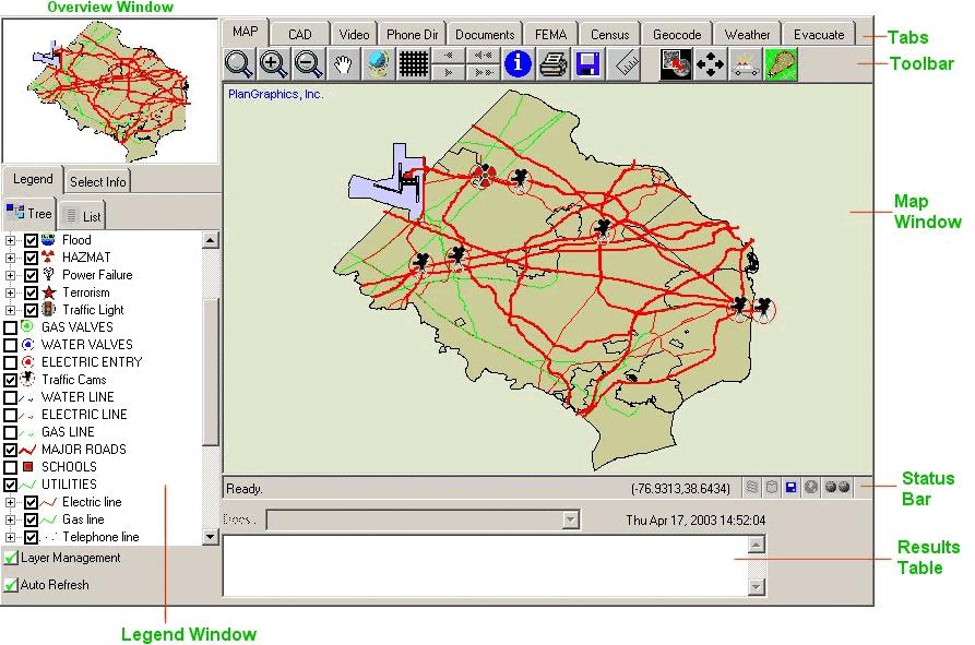
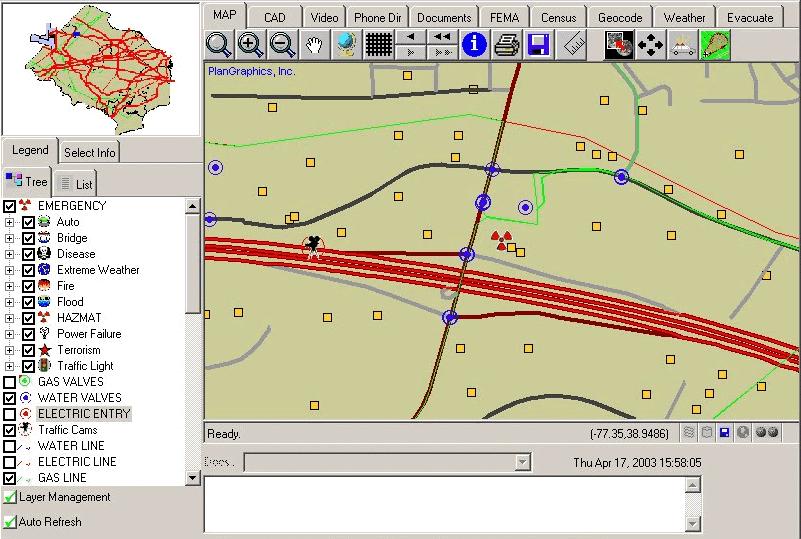
FEMA has the only computerized damage assessment
 The Assessor as an Integral Partner in Disaster Planning, Response, and Recovery: 2. Demonstration of an Integrated Damage Assessment Model By Morgan B. Gilreath, Jr. This article is the second in a two-part
Tax Credit Management Abilities
 Web-Based, ASP Hosted, Enterprise Class Property Management Software Tax Credit Management Abilities Dear Property Manager, Property management software is becoming more and more complicated and loaded
IBM TRIRIGA Version 10 Release 5.2. Real Estate Transaction Management User Guide IBM
 IBM TRIRIGA Version 10 Release 5.2 Real Estate Transaction Management User Guide IBM Note Before using this information and the product it supports, read the information in Notices on page 11. This edition
Property Management Under Uniform Guidance (UG)
") Property Management Under Uniform Guidance (UG) Presented by: Gelman, Rosenberg & Freedman CPAs Jennifer Arminger, CPA, Partner Jim Larson, CPA, Partner and E-ISG Asset Intelligence Jackie Luo, CEO Property
Property Management Under Uniform Guidance (UG) Presented by: Gelman, Rosenberg & Freedman CPAs Jennifer Arminger, CPA, Partner Jim Larson, CPA, Partner and E-ISG Asset Intelligence Jackie Luo, CEO Property
2014 Plan of Conservation and Development. Development Plan & Policies
 The Town of Hebron Section 3 2014 Plan of Conservation and Development Development Plan & Policies C. Residential Districts I. Residential Land Analysis This section of the plan uses the land use and vacant