Spatially Enabled Society Role of the Cadastre
|
|
|
- Harvey Wilson
- 6 years ago
- Views:
Transcription
1 armasuisse Bundesamt für Landestopografie swisstopo Swiss Federal Directorate for Cadastral Surveying Spatially Enabled Society Role of the Cadastre XXIV FIG International Congress 2010 FIG-Task Force «Spatially Enabled Society» Dr. Daniel Steudler and Dr. Abbas Rajabifard Table of Content Introduction Problems that global community is facing, the needs of societies Role of landownership Vision statements for a Spatially Enabled Society 2 Sydney, Australia, April

2 Reversal of perspective What does society need? What are its requirements? Problems that humankind, respective we as a global community are facing: pollution, climate change, global warming, sea level rising, disaster management, shortage of natural and energy resources, land grabbing, mobility, traffic, global financial crisis, overpopulation, increasing urbanization, poverty UN - Millennium Development Goals by 2015: eradication of extreme poverty and hunger, ensure environmental sustainability, develop global partnership for development 3 World status of poverty 4 Sydney, Australia, April


3 World Map of GDP 32 5 Urban population growth RURAL 63% URBAN 37% RURAL 53% URBAN 47% RURAL 40% URBAN 60% Total world population : 6.5 billion 2007: Total urban population: 3.3 billion Total slum dwellers: 1.1 billion 6 Sydney, Australia, April

4 Kibera Kibera, Nairobi, 250 ha, 1 mill+ people 7 Bandah Aceh before Tsunami 8 Sydney, Australia, April


5 Bandah Aceh after Tsunami 9 Aceh: mosque in washed out land 10 Sydney, Australia, April

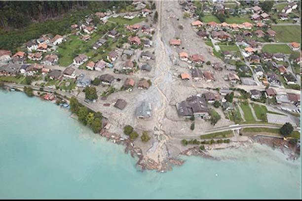
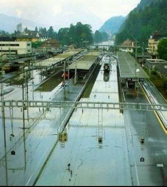
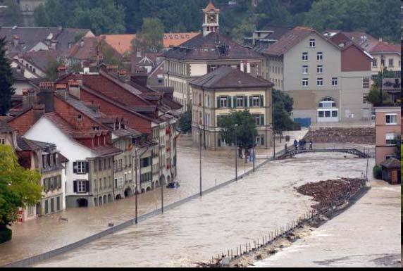
6 Flooding in Switzerland 11 Architects model I 12 Sydney, Australia, April


7 Architects model II 13 Architects model III 14 Sydney, Australia, April


8 Architects model IV 15 House of global community 16 Sydney, Australia, April
9 How to approach such challenges? as any other problems, global problems have a spatial dimension ("everything happens somewhere"); in order to overcome such problems, to monitor them and to do the proper planning, data and information is required; this information has to represent reality as close as possible; data modelling is needed in order to organize the information involved; these data models have to: represent the actual situation, provide the basis for planning and monitoring the projects, be able to do simulations of alternatives of the planned solutions, provide the correct location spatial enablement. 17 Three ingredients for spatial enablement of society's needs positioning infrastructure content land ownership information 18 Sydney, Australia, April

10 Role of landownership everything happens somewhere; always on somebody's property; for planning, monitoring and sustainable development, landownership data is required; even when property is state owned, society needs to know; society needs a documentation system for landownership as a basis for informed decision-making. 19 Documentation of landownership in history Domesday Book (William the Conqueror) 1086 Maria Theresia Cadastre (Austro-Hungarian Monarchy ) 1792 Cadastre by Napoleon Sydney, Australia, April

11 3 dimensions of the cadastre for sustainability Economic dimension Fiscal income for government Transparent land market Administration of public-rights restrictions provides a more transparent land market Social dimension Legal security of ownership provides social security Environmental dimension Resource planning and management Land-use planning, management of zoning 21 Land management and landownership land consolidation is an essential tool for good land management; this tool is suited for agricultural areas; but also for urban areas; and for larger zoning projects such as for example for "industrial zoning consolidation" across municipalities; land consolidation always needs landownership information. 22 Sydney, Australia, April

12 Land administration in a larger context Tasks Land related activities Tools / Methods Strategy visions and objectives Land policy political activities Management measures and projects for the implementation of the policy Land management land-use planning land consolidation land reallocation melioration landscape development land recycling Administration / Documentation handling of spatial information, data analysis, data visualization cadastral operations, data modelling, data acquisition, data maintenance, data distribution Land administration and cadastre monitoring navigation geoinformation land registration cartography surveying geodesy 23 Lack of landownership information in disaster management Thailand after Tsunami: lack of proper landownership information allowed financial investors to take over land, while local fisherman have been ousted from their properties a well documented landownership information would have protected minorities with lesser economic power against exploitation. Aceh: the lack of a land registry and cadastre caused huge problems for reconstruction, planning, and social stability. Haiti: clear landownership information would support a much quicker recovery (Kappeler, 2010). Disaster management starts before the disaster; landownership information is crucial. 24 Sydney, Australia, April


13 Inventory of natural hazards in combination with landownership information 25 Private landownership supporting environmental sustainability Azerbaijan after transition in 1990's: private landownership was introduced initially for land within the village only; land outside the villages remained common property respective state property; village society was not sufficiently organized; sheep secure the income of the rural population; sheep stock became approx. 5 times as big as the actual capacity of the land would have been; serious erosion and degradation problems; basic problem was the lack of responsibility and accountability. 26 Sydney, Australia, April
14 Landownership plays a central role landownership data is required for planning, monitoring and sustainable development; disaster management starts before the disaster; landownership information is crucial; accountability: only stakeholders with ownership rights i.e. landowners take responsibility; tools for land management need reliable landownership information. Private landownership is crucial; it needs to be secured by an appropriate land policy driven by sustainable development principles and documented with an efficient and reliable land administration system. 27 Positioning infrastructure "everything happens somewhere" many business applications are in need of position data CORS provide high accuracy business cases show a high potential (Higgins, 2009) accuracy not really a problem anymore nowadays A positioning infrastructure provides the spatial enablement of content. 28 Sydney, Australia, April
15 Modelling of content based on the positioning infrastructure, content is added to locations; content needs to be organized, i.e. modelled in order to be helpful for monitoring, planning, and managing change; the data model behind has to represent reality as close as possible; data modelling would have to be done according to accepted standards in order to share the data and allow ease of use; Data modelling is the enabling technology to organize the content of data. Data modelling standards are crucial for the sharing of data. 29 Statement 3 on Cadastre 2014 cadastral modelling 'Cadastral mapping' will be dead! Long live modelling! 30 Sydney, Australia, April

 Sydney, Australia, 11 16")
16 Structure for land information system Legal topic spatial data textual data Stakeholders (data owners) Water protection Local government Noise protection Local government Environmental protection Environmental department Land use planning Planning department Indigenous land rights Tribe, clan Collective land rights Corporations Land ownership, cadastre National government State government Local government Two preconditions: common geodetic reference framework common data modelling concept 31 The Social Tenure Domain Model Party Social Tenure Relationship Spatial Unit Right Parcel Person (Lemmen, 2009) Sydney, Australia, April


17 Network infrastructure Spatial Data Infrastructure Less detailed data Vertical Relationship Horizontal Relationship Global Decisions Regional Decisions National Decisions State Decisions Local Decisions Organizational Decisions Global SDI Regional SDI National SDI State SDI Local SDI Organizational SDI More detailed Data Rajabifard, 2007 Network infrastructure for sharing spatial data. 33 Data and information We are living in the information age, where patchwork information is not good enough. Data needs to be: comprehensive complete updated reliable 34 Sydney, Australia, April
18 Public sector information (PSI) spatial data, above all, cadastral information tends to be managed by government and is often not readily available; value of data lies in its use; fee policies vs. cost recovery policy or the balance between accessibility and cost recovery; PSI needs to be accessible in an efficient way. PSI initiative in Europe GILF initiative in Australia (GILF = Government Information Licensing Framework, gilf.gov.au) Public sector information needs to be accessible in defined and easy ways in order to facilitate its multiple use. 35 Six vision statements for a SES A society is spatially enabled, when: 1. A positioning infrastructure is in place. 2. Content is added with data modelling standards in place that allow to model reality as close as possible. 3. Private landownership is established, well documented, and its information readily available. 4. A network infrastructure for spatial data is in place in order to provide access to data and information. 5. Data and information is comprehensive, complete, updated, and reliable. 6. Access to relevant public sector information is organized and efficient. 36 Sydney, Australia, April
19 Changing role of (cadastral) surveyors from measurement to management global land management perspective land administration systems provide the infrastructure for implementing land policy and land management strategies in support of sustainable development no development will take place without a spatial component we are not talking of maps any longer, we are in the information business!!! 37 Sydney, Australia, April
Spatial Enablement and the Response to Climate Change and the Millennium Development Goals
 Spatial Enablement and the Response to Climate Change and the Millennium Development Goals Prof. Stig Enemark President Aalborg University, Denmark 18th UNITED NATIONS REGIONAL CARTOGRAPHIS CONFERENCE
The Boundary Concept Land Management Opportunities for Sustainable Development Provided by the Cadastre 2014 Approach. Jürg KAUFMANN, Switzerland
 The Boundary Concept Opportunities for Sustainable Development Provided by the Cadastre 2014 Approach Jürg KAUFMANN, Switzerland THE BOUNDARY CONCEPT AS A CHANCE FOR SURVEYORS OPPORTUNITIES CREATED BY
Cadastral Futures building a new vision for the nature and role of cadastres. XXIV FIG International Congress Sydney, April 11-15
 Cadastral Futures building a new vision for the nature and role of cadastres XXIV FIG International Congress Sydney, April 11-15 Rohan Bennett, Abbas Rajabifard, Mohsen Kalantari, Jude Wallace, Ian Williamson
Facing the global agenda Outline of presentation
 The global surveying profession Global Trends towards a Spatially Enabled Society Prof. Stig Enemark President Aalborg University, Denmark AREAL OG EJENDOM 2009 - NORGES JORDSKIFTEKANDIDATFORENING VESTBY
Country Report SWITZERLAND
 armasuisse Federal Office of Topography, swisstopo Country Report SWITZERLAND Dr. Daniel Steudler Swiss Annual Meeting 2013, FIG-Commission 7 22 October 2013, Yaoundé, Cameroon Basic Dimensions SWITZERLAND
Centre for SDIs and Land Administration Department of Geomatics Spatial systems to support sustainable development
 Centre for SDIs and Land Administration Department of Geomatics MODERN CADASTER and LAND ADMINISTRATION تهران-مرداد 1386 2014 ..... 2 ماه Centre for SDIs and Land Administration Department of Geomatics
Land Markets and Land Rights in support of the Millennium Development Goals
 Land Markets and Land Rights in support of the Millennium Development Goals A Global Perspective Prof. Stig Enemark President Aalborg University, Denmark 3rd LAND ADMINISTRATION FORUM FOR THE ASIA AND
Land Administration and Management Towards the Fifth Dimension
 Bundesamt für Landestopografie swisstopo Eidgenössische Vermessungsdirektion Land Administration and Management Towards the Fifth Dimension Geoconference on Cadastre 4.0, 25/26 Oct. 2016 Dr. Daniel Steudler
Cadastre A Vision on Future Cadastral Systems
 Cadastre 2014 - A Vision on Future Cadastral Systems Jürg Kaufmann - 1 - CONTENTS ABOUT FIG ENVIRONMENT FOR THE DEVELOPMENT OF CADASTRE 2014 DEVELOPMENT OF CADASTRE 2014 PRINCIPLES OF CADASTRE 2014 EFFECTS
The Message FIG-WB Partnership on Land Governance in Support of the Global Agenda
 FIG-WB Partnership on Land Governance in Support of the Global Agenda Prof. Stig Enemark, Denmark President 2007-2010 Mr. Teo Chee Hai, Malaysia President Elect 2011-2014 WORLD BANK LAND GROUP, WASHINGTON,
Land Management and Cadastre a Symbiotic Interaction?
 Land Management and Cadastre a Symbiotic Interaction? Dr. Alexander Kohli, Switzerland geosuisse, Delegate to Commission 8, Sydney, Australia, TS 8E Law and Planning Agenda 1. Introduction and Motivation
CADASTRE 2014: New Challenges and Direction
 CADASTRE 2014: New Challenges and Direction Anna KRELLE and Abbas RAJABIFARD, Australia Key words: Cadastre, Cadastre 2014, Land Administration SUMMARY Land and land related activities form part of the
Good Land Governance for the 2030 Agenda
 Good Land Governance for the 2030 Agenda Addis Ababa, Ethiopia 20-22 April, 2014 Role of Geospatial Information in Good Land Policy and Governance Oumar Sylla UN-Habitat/GLTN oumar.sylla@unhabitat.org
Land Administration and Management Towards the Fifth Dimension
 Presented at the FIG Working Week 2016, May 2-6, 2016 in Christchurch, New Zealand Bundesamt für Landestopografie swisstopo Eidgenössische Vermessungsdirektion Land Administration and Management Towards
Land Administration in support of the Global Agenda: Current FIG Policies
 Land Administration in support of the Global Agenda: Current FIG Policies Prof. Stig Enemark President Aalborg University, Denmark FIG COMMISSION 7 ANNUAL MEETING VERONA, ITALY, SEPTEMBER 2008 Current
Sustainable Land Management based on Fast Approach Cadastral Documentation
 Sustainable Land Management based on Fast Approach Cadastral Documentation Dr. Alexander Kohli, Vice-President SWISS LAND MANAGEMENT FOUNDATION Agenda 1. Basic Principles of Data Modeling in a Spatially
International Trends in Land Administration. Land Administration
 Bundesamt für Landestopographie Office fédéral de topographie Ufficio federale di topografia Uffizi federal da topografia International Trends in Daniel Steudler Swiss Federal Directorate of Cadastral
Basic view. View of the report View of Cadastre 2014
 Basic view Standardized core cadastral domain model serves to: Avoid reinventing and reimplementing th same functionality again and again Enabel involved parties to communicate based on an shared ontology
UN-HABITAT s Mission and Vision. Sustainable urban development Adequate shelter for all
 GLTN contributes to the implementation of pro poor land policies to achieve secure land rights for all www.gltn.net GLTN Secretariat, facilitated by PO Box 30030, Nairobi 00100, Kenya Tel: +254 20 762
The importance of changes in land surveyors education
 András OSSKÓ Key words: land administration, roles of land surveyors, extended education, lifelong learning SUMMARY It s a world wide experience, especially in developed countries that the interest in
Greetings from Denmark. Property Rights, Restrictions and Responsibilities - A Global Land Management Perspective. Wonderful Copenhagen
 Property Rights, Restrictions and Responsibilities - A Global Land Management Perspective Greetings from Denmark 43,000 sq km Prof. Stig Enemark President Aalborg University, Denmark Aalborg Copenhagen
UNPLANNED URBAN DEVELOPMENT
 National Technical University of Athens School of Rural and Surveying Engineering UNPLANNED URBAN DEVELOPMENT Chryssy A Potsiou, Lecturer NTUA chryssyp@survey.ntua.gr UNECE WPLA WORKSHOP EFFECTIVE AND
Scenic Nepal. Land Administration Systems. Outline of Presentation. Interests in land. Rights: Registration and security of tenure positions
 Scenic Nepal Land Administration Systems Managing Rights, Restrictions, and Responsibilities in Land Prof. Stig Enemark President Aalborg University, Denmark SURVEY DEPARTMENT KATHMANDU, NEPAL. 16 FEBRUARY
DATR towards e-land Administration in Hungary
 DATR towards e-land Administration in Hungary Gyula IVÁN-Gábor SZABÓ-Zoltán WENINGER-Piroska Zalaba Institute of Geodesy, Cartography and Remote Sensing, Budapest, HUNGARY XXIV. FIG Congress Facing the
Rudolf KÜNTZEL and Jürg KAUFMANN, Switzerland
 Rudolf KÜNTZEL and Jürg KAUFMANN, Switzerland Key words: land management, cadastre, land administration, cyclic land management process, education of land professionals SUMMARY Sustainable development
Creation Land Administration in Formal and Informal Environment. FIG Commission 7 Working Group 1
 Creation Land Administration in Formal and Informal Environment András OSSKÓ, Hungary Key words: land administration, informal land tenure, customary tenure, sustainable Development. SUMMARY FIG Commission
Cadastre and Other Public Registers: Multipurpose Cadastre or Distributed Land Information System?
 Cadastre and Other Public Registers: Multipurpose Cadastre or Distributed Land Information System? Ivan PESL, Czech Republic Key words: Cadastre, Land Registry, Property, Taxes, Land Use, Territorial Planning,
Land Governance in Support of The Millennium Development Goals. Stig Enemark Paul van der Molen Robin McLaren
 Land Governance in Support of The Millennium Development Goals Stig Enemark Paul van der Molen Robin McLaren INV 1 - Land Governance in Support of the Millennium Development Goals Sydney, Australia, 11-16
Seventh Session of the United Nations Committee of Experts on Global Geospatial Information Management
 Report of the Forum P a g e 1 Seventh Session of the United Nations Committee of Experts on Global Geospatial Information Management Report of the Forum Secure Land Rights and Smart Cities - Making It
Flying high and Keeping the feet on the ground
 Building the Capacity The FIG Agenda and Achievements 2007-2010 Prof. Stig Enemark President FACING THE CHALLENGES BUILDING THE CAPACITY FIG CONGRESS, SYDNEY, AUSTRALIA, 11-16 APRIL 2010 The Agenda Building
Presented at the FIG Congress 2018, May 6-11, 2018 in Istanbul, Turkey
 Presented at the FIG Congress 2018, May 6-11, 2018 in Istanbul, Turkey 5 Bibliometric Analysis of Articles Presented Under Commission 7: A Case of the 25th Fig Congress in Malaysia in 2014 Zeynel Abidin
Land surveying is probably the (second) oldest profession in the world
 oldest profession in the world") Land Surveying and Land Management in an International Perspective Prof Stig Enemark Honorary President Aalborg University, Denmark CADASTRE IN A DIGITAL WORLD NORDIC AND GLOBAL PRESPECTIVES INTERNATIONAL
Land Surveying and Land Management in an International Perspective Prof Stig Enemark Honorary President Aalborg University, Denmark CADASTRE IN A DIGITAL WORLD NORDIC AND GLOBAL PRESPECTIVES INTERNATIONAL
Cadastre: definitions
 Introduction New vision towards a multipurpose cadastral system to support land management in Morocco Moha EL-AYACHI, El Hassane SEMLALI, Mohamed ETTARID, Driss TAHIRI, Institut Agronomique et Vétérinaire
Click to edit Master title style
 Click to edit Master title style Modern Cadastre and Land Administration Session 5a. The toolbox approach Jude Wallace 2007 Click to edit Overview Master title style Objectives To understand the circumstances
Participants of the Ministerial Meeting on Housing and Land Management on 8 October 2013 in Geneva
 Summary At its meeting on 2 April 2012, the Bureau of the Committee on Housing and Land Management of the United Nations Economic Commission for Europe agreed on the need for a Strategy for Sustainable
Addressing Land Sector Opportunities with Geospatial Information in Nepal
 The 20th UNRCC-AP and the 4th UN-GGIM-AP 5-10 October 2015 Jeju Island, Republic of Korea Addressing Land Sector Opportunities with Geospatial Information in Nepal Krishna Raj BC Executive Director Land
AFRICA REGIONAL NETOWORK
 Facing the Global Agenda - The Role of Land Professionals Prof. Stig Enemark FIG Honorary President Aalborg University, Denmark AFRICA REGIONAL NETOWORK Challenges and Opportunities in Facing the SDG s:
Progress in modern cadastre Challenging existing models and paradigms
 Progress in modern cadastre Challenging existing models and paradigms Gerda Schennach, Austria Chair of FIG Commission 7 Federal Office of Metrology and Surveying, Austria The Value of Cadastre for Society
Incorporating Sustainable Development Objectives into ICT Enabled Land Administration Systems - Case Study Switzerland
 EXPERT GROUP MEETING ON INCORPORATING SUSTAINABLE DEVELOPMENT OBJECTIVES INTO ICT ENABLED LAND ADMINISTRATION SYSTEMS 9-11 November 2005, Centre for Spatial Data Infrastructures and Land Administration
Lessons for federated countries that have state land registries the Australian experience
 Lessons for federated countries that have state land registries the Australian experience Ian Williamson Centre for SDI and Land Administration Department Infrastructure Engineering University of Melbourne
Rapid Urbanization What can land surveyors do? Paul van der MOLEN. % (millions) % Rural ,974 3, ,
 % Rural ,974 3, ,") Rapid Urbanization What can land surveyors do? Paul van der MOLEN What is it all about? population World Urban % Rural % (millions) (millions) (millions) 2011 6,974 3,632 52.1 3,341 47.9 2050 9,306 6,252
Rapid Urbanization What can land surveyors do? Paul van der MOLEN What is it all about? population World Urban % Rural % (millions) (millions) (millions) 2011 6,974 3,632 52.1 3,341 47.9 2050 9,306 6,252
Cadastral Template. FIG-Commission 7 Annual Meeting, Verona, Italia, 12 Sept Daniel Steudler
 armasuisse Bundesamt für Landestopografie swisstopo Cadastral Template FIG-Commission 7 Annual Meeting, Verona, Italia, 12 Sept. 2008 Design Principles for the Template keep it simple in order to attract
Enhancements of the Cadastral System in Switzerland
 Enhancements of the Cadastral System in Switzerland «Cadastre of Public-Law Restrictions on Landownership» and «National Utility Cadastre» Christoph Käser Content 1. Cadastre of Public-Law Restrictions
National Technical University of Athens School of Rural and Surveying Engineering
 National Technical University of Athens School of Rural and Surveying Engineering INFORMAL SETTLEMENTS REAL ESTATE MARKET NEED FOR GOOD LAND ADMINISTRATION AND PLANNING FIG COM3, UNECE CHLM & WPLA JOINT
REGISTRATION OF PROPERTIES IN STRATA
 REGISTRATION OF PROPERTIES IN STRATA REPORT ON THE WORKING SESSIONS INTRODUCTION A cadastre is usually, and in most countries, a parcel-based, and up-to-date land information system containing records
Keith Clifford Bell The World Bank -East Asia and the Pacific Region WASHINGTON D.C., USA
 Keith Clifford Bell The World Bank -East Asia and the Pacific Region WASHINGTON D.C., USA 4th Land Administration Forum for the Asia and Pacific Region Beyond Spatial Enablement October 5-7, 2011 Melbourne,
CADASTRE 2014: FROM THEORY TO PRACTICE
 CADASTRE 2014: FROM THEORY TO PRACTICE Jürg KAUFMANN, Switzerland CONTENTS Cadastre 2014 - A Vision for a Future Cadastral System: A publication from FIG. How did the surveying community react to these
PROBLEMS IN REGISTRATION IN THE THIRD VERTICAL DIMENSION IN THE UNIFIED LAND REGISTRY IN HUNGARY, AND POSSIBLE SOLUTION
 3D Cadastres Technical and Legal Aspects II PROBLEMS IN REGISTRATION IN THE THIRD VERTICAL DIMENSION IN THE UNIFIED LAND REGISTRY IN HUNGARY, AND POSSIBLE SOLUTION ANDRÁS Osskó Budapest Land Office Hungary
Well-functioning Real Estate Markets Criteria and Examples (9076)
") Presented at the FIG Working Week 2017, May 29 - June 2, 2017 in Helsinki, Finland FIG Task Force Real Estate Market Studies Well-functioning Real Estate Markets Criteria and Examples (9076) Prof. Dr.-Ing.
Presented at the FIG Working Week 2017, May 29 - June 2, 2017 in Helsinki, Finland FIG Task Force Real Estate Market Studies Well-functioning Real Estate Markets Criteria and Examples (9076) Prof. Dr.-Ing.
Spatial Data Infrastructure for knowledge sharing
 , THE NETHERLANDS Key words: SDI, knowledge sharing, people profit planet, Kadaster, system of key registers, good governance, e-government, spatially enabled society, GIDEON SUMMARY Today s global challenges
PCC conference Tällberg. Aspects on development cooperation
 PCC conference Tällberg Aspects on development cooperation PCC conference Tällberg WHO I AM Anders Åberg, Project Leader Posted over seas 10 years Tanzania 1978 1980 Vietnam 1987 1990 Laos 2004 2008 Now
WHAT IS AN APPROPRIATE CADASTRAL SYSTEM IN AFRICA?
 WHAT IS AN APPROPRIATE CADASTRAL SYSTEM IN AFRICA? Tommy ÖSTERBERG, Sweden Key words: ABSTRACT The following discussion is based on my experiences from working with cadastral issues in some African countries
THINK BIG do little. Start an avalanche
 1 Recent activities on land consolidation in Serbia Stevan Marosan, Mladen Soskic University of Belgrade, Faculty of Civil Engineering Department for Geodesy and Geoinformatics Zoran Knezevic Ministry
Advances in Modern Land Administration Cadastre 2014 in the Year 2006
 Advances in Modern Land Administration Cadastre 2014 in the Year 2006 Winfried HAWERK, Germany Key words: E-Land Administration, IT renewal strategies SUMMARY FIG Commission 7 Working Group 7.3 deals with
Development of Cadastral Survey and Land Ownership Registration System in Mongolia
 Development of Cadastral Survey and Land Ownership Registration System in Mongolia M.Saandar,, Ph. D Vice President, the Mongolian Association of Surveying and Mapping, ( As National Member of FIG ) MonMap
The Bathurst Declaration on Land Administration for Sustainable Development
 United Nations and International Federation of Surveyors The Bathurst Declaration on Land Administration for Sustainable Development The Story The cumulative evolution of society s land administration
Egyptian Nationwide Title Cadastre System
 Kholoud SAAD, Egypt Key words: Cadastre, Registration, Urban, Rural, National Cadastre, Automation, reengineering. SUMMARY With growing need for integrated information, Enterprise Solutions has become
The New Swiss Law on Geoinformation and the Ordinance. on thecadastre on Public Law Restrictions (4064)
") on thecadastre on Public Law Restrictions (4064) 1. INTRODUCTION 2. STARTING CONDITIONS 3. TIME FRAME 4. RESULTs OF THE WORK 5. CONTENT OF THE ACT ON GEOINFORMATION 6. CADASTRE OF THE PUBLIC-RIGHT RESTRICTIONS
on thecadastre on Public Law Restrictions (4064) 1. INTRODUCTION 2. STARTING CONDITIONS 3. TIME FRAME 4. RESULTs OF THE WORK 5. CONTENT OF THE ACT ON GEOINFORMATION 6. CADASTRE OF THE PUBLIC-RIGHT RESTRICTIONS
Ignition for Fit For Purpose Land Administration in Nepal
 Presented at the FIG Working Week 2017, May 29 - June 2, 2017 in Helsinki, Finland Ignition for Fit For Purpose Land Administration in Nepal Paula Dijkstra (Netherlands), David Mitchell, Rohan Bennett
A beautiful setting. The Evolving Role of Cadastral Systems in Support of Good Land Governance. Setting the scene
 The Evolving Role of Cadastral Systems in Support of Good Land Governance Prof. Stig Enemark President Aalborg University, Denmark THE DIGITAL CADASTRAL MAP FIG COMMISSION 7 OPEN SYMPOSIUM KARLOVY VARY,
THE 2030 AGENDA, CITIES AND URBAN GOVERNANCE A CENTRAL ROLE FOR LAND AND GEOSPATIAL INFORMATION
 THE 2030 AGENDA, CITIES AND URBAN GOVERNANCE A CENTRAL ROLE FOR LAND AND GEOSPATIAL INFORMATION Abbas Rajabifard Immediate Past President and Executive Board Member, GSDI Association Director, Centre for
Land consolidation and rural development in Serbia
 1 Land consolidation and rural development in Serbia Stevan Marosan University of Belgrade, Faculty of Civil Engineering, Department for Geodesy and Geoinformatics Maja Trajkovic Ministry of Finance Vladan
Croatian SDI: a Tool for Accelerated Development of the Geo-Conscious Society
 STATE GEODETIC ADMINISTRATION Croatian SDI: a Tool for Accelerated Development of the Geo-Conscious Society Prof.Dr.Sc. Željko Bačić, Mr.Sc. Ljerka Rašić FIG Working Week 2009 - Surveyors Key Role in Accelerated
Galicia 2009 Regional Workshop on Land Tenure and Land Consolidation. FAO s Experience with Land Development Instruments in Europe
 Galicia 2009 Regional Workshop on Land Tenure and Land Consolidation FAO s Experience with Land Development Instruments in Europe Santiago de Compostela Galicia 9-11 of February 2009 Richard Eberlin Land
From Measurement to Management
 From Measurement to Management The changing role of the land surveyors Prof. Stig Enemark Aalborg University, Denmark LAND MANAGEMENT AND HUMAN RIGHTS INTERNATIONAL SEMINAR, HØGSKOLEN I BERGEN, 8 9 SEPTEMBER
AN OVERVIEW OF LAND TOOLS IN SUB- SAHARAN AFRICA: PAST, PRESENT AND FUTURE
 AN OVERVIEW OF LAND TOOLS IN SUB- SAHARAN AFRICA: PAST, PRESENT AND FUTURE BY CLARISSA AUGUSTINUS CHIEF, LAND AND TENURE SECTION UNHABITAT Nairobi, 11-11-2004 WHY UN-HABITAT HAS CO-SPONSORED THIS EGM UN-HABITAT
Importance of Spatial Data Infrastructure in the UNECE Region. Amie Figueiredo INSPIRE Conference 2016 Barcelona, 26 September 2016
 Importance of Spatial Data Infrastructure in the UNECE Region. Amie Figueiredo INSPIRE Conference 2016 Barcelona, 26 September 2016 United Nations Economic Commission for Europe 56 member States in Europe,
Land Administration And Spatial Data Infrastructures
 Land Administration And Spatial Data Infrastructures Ian WILLIAMSON, Donald GRANT and Abbas RAJABIFARD Centre for SDIs and Land Administration Department of Geomatics University of Melbourne, Australia
Dimension Cadastre Stepping Beyond Limits
 Swiss Federal Directorate for Cadastral Surveying Dimension Cadastre Stepping Beyond Limits Dr. Daniel Steudler Background Think Tank active since 2012; aim is to identify the current trends in the geoinformation
The Cadastral Template 2.0, From Design to Implementation
 Abbas RAJABIFARD (Australia), Daniel Steudler (Switzerland), Ali AIEN, and Mohsen KALANTARI, Australia Key words: Cadastral Template 2.0, Cadastral Template Project, Land Administration, PCGIAP SUMMARY
Promising times for surveyors. Land Administration in Europe -new challenges and opportunities- Formalised property rights
 Promising times for surveyors Land Administration in Europe -new challenges and opportunities- Helge Onsrud Statens kartverk Norway helge.onsrud@statkart.no From playing a key role in understanding, exploring
KHANALIBAYLI UNECE WPLA
 UNECE Working Party on Land Administration The role of the UNECE Working Party on Land Administration (WPLA) in the promotion and improvement of land administration and land management in the UNECE region
LAND TENURE IN ASIA AND THE PACIFIC CHALLENGES, OPPORTUNITIES AND WAY FORWARD
 LAND TENURE IN ASIA AND THE PACIFIC CHALLENGES, OPPORTUNITIES AND WAY FORWARD Workshop on Land Administration and Management 20th United Nations Regional Cartographic Conference for Asia and the Pacific
Cadastral Template 2003
 PCGIAP-Working Group 3 "Cadastre" FIG-Commission 7 "Cadastre and Land Management" Cadastral Template 2003 The establishment of a cadastral template is one of the objectives of Working Group 3 "Cadastre"
Reconstruction in Haiti: A Land Rights Infrastructure to Support its Sustainable Development. Context in Haiti
 Reconstruction in Haiti: A Land Rights Infrastructure to Support its Sustainable Development Daniel Roberge Michel Paradis Mike Mora Sydney, Australia April 14 th 2010 Context in Haiti Haiti is the poorest
THE NEED FOR APPROACHES AND TECHNOLOGY OF TOMORROW
 THE NEED FOR APPROACHES AND TECHNOLOGY OF TOMORROW KEES DE ZEEUW, CHRISTIAAN LEMMEN and BERNY KERSTEN Cadastre, Land Registry and Mapping Agency - Kadaster, The Netherlands Kees.dezeeuw@kadaster.nl Paper
NATIONAL LAND POLICY ON AGRICULTURE DEVELOPMENT
 NATIONAL LAND POLICY ON AGRICULTURE DEVELOPMENT Prepared by: J.M.Kami Director of Land Use Coordination and Policy Presented by: NATIONAL LAND USE PLANNING COMMISSION Towards a New National Land Policy
New Technology for Cadastral Systems. Brent Jones, PE, PLS
 New Technology for Cadastral Systems Brent Jones, PE, PLS Benefits of Good Land Administration Key to addressing global challenges.. Secure Tenure Equitable Land and Property Taxation Support for Government
Country report, HUNGARY
 Country report, HUNGARY Gyula IVÁN Institute of Geodesy, Cartography & Remote Sensing (FÖMI) HUNGARY FIG Commission 7 Annual Meeting 2009 12-16 October, 2009, Kuala Lumpur, Malaysia Institute of Geodesy,
PROJECT INFORMATION DOCUMENT (PID) APPRAISAL STAGE Report No.: PIDA Project Name. Region Country Sector(s) Theme(s)
 APPRAISAL STAGE Report No.: PIDA Project Name. Region Country Sector(s) Theme(s)") Public Disclosure Authorized Public Disclosure Authorized Public Disclosure Authorized Public Disclosure Authorized Project Name Region Country Sector(s) Theme(s) Lending Instrument Project ID Borrower(s)
Public Disclosure Authorized Public Disclosure Authorized Public Disclosure Authorized Public Disclosure Authorized Project Name Region Country Sector(s) Theme(s) Lending Instrument Project ID Borrower(s)
FORMALIZATION OF INFORMAL REAL ESTATE. Prof Chryssy Potsiou FIG President, UNECE WPLA bureau member
 FORMALIZATION OF INFORMAL REAL ESTATE Prof Chryssy Potsiou FIG President, UNECE WPLA bureau member chryssy.potsiou@gmail.com Procedures for the legalization and registration of buildings and building units-challenges
Flying high and Keeping the feet on the ground
 Building the Capacity The Agenda and Achievements 2007-2010 FIG handover ceremony, FIG headquarters, Copenhagen, 26 November 2010 The Agenda Building the Capacity through Flying high and Keeping the feet
THINKING OUTSIDE THE TRIANGLE TAKING ADVANTAGE OF MODERN LAND MARKETS. Ian Williamson
 THINKING OUTSIDE THE TRIANGLE TAKING ADVANTAGE OF MODERN LAND MARKETS Ian Williamson Professor of Surveying and Land Information Head, Department of Geomatics Director, Centre for Spatial Data Infrastructures
FIG Commission 3 Spatial Information Management. Report of Activities 2009
 Appendix to item 10.3 Report to the 33 rd General Assembly FIG Congress in Sydney, Australia 2010 FIG Commission 3 Spatial Information Management Report of Activities 2009 1. General Since 2007, FIG Commission
The Cadastre of Public-law Restrictions on Landownership in Switzerland
 The Cadastre of Public-law Restrictions on Landownership in Switzerland The new official land registry information system Maurice Barbieri, CLGE President Zagreb, 26.November 2015 Utility Cadastre Seminar
LIS a motivation for SDI initiative
 Eric Mwaikambo Ardhi University Dar es Salaam Tanzania Overview Status of LIS in Tanzania Relationship between SDI and LIS Spatial Standards LIS a motivation for SDI initiative Conclusion & Recommendations
Land and the New Urban Agenda EGM June 2016
 EGM June 2016 Filiep Decorte Deputy Director New York Liaison Office UN-Habitat 2 August 2016 ROLE OF LAND IN URBAN DEVELOPMENT The New Urban Agenda is about people People need a place to live. Place means
Establishment of a land market in Ukraine: current state and prospects
 Establishment of a land market in Ukraine: current state and prospects More than 25 years have passed since the adoption of the first resolution of the Verkhovna Rada On Land Reform. Despite such a long
Land Consolidation Thesaurus finding common ground. 9 th International LANDNET workshop 3-5 October 2017 Budapest, Hungary
 Land Consolidation Thesaurus finding common ground 9 th International LANDNET workshop 3-5 October 2017 Budapest, Hungary Maxim Gorgan, Land Tenure and Rural Development Specialist, FAO Regional Office
Challenges for the multi purpose cadastre
 Jens RIECKEN, Markus SEIFERT, Germany Key words: Multi purpose cadastre, 3d-cadastre, land use, SDI, solar cadastre SUMMARY Over the past 30 years, with the progress of information technologies the development
E fficient L and A dministr ation E ncour ages P r oper ty M ar k ets. surveying companies at Project commencement. Key Messages
 Secur ing Pr oper ty R ights and I ncr easing R eal E state Pr oductivity in F Y R M acedonia Victoria Stanley, Denis Boskovski and Samantha De Martino Key Messages Before 2005, FYR Macedonia did not have
Building Integrated Land Information Systems and Development of NSDI
 Stig JÖNSSON, Sweden Key words: Land administration, land information systems, property formation, spatial data infrastructure, Inspire, institutional cooperation SUMMARY Lantmäteriet the Swedish agency
Land Tools for Tenure Security for All
 Land Tools for Tenure Security for All PROF. JAAP ZEVENBERGEN UNIVERSITY OF TWENTE - ITC 1 ST JUNE 2017 HELSINKI, FINLAND GLOBAL LAND CHALLENGES 70 % Dealing with the affordability issue - how to modernize
GLTN LAND TOOLS -SOME EXAMPLES-
 GLTN LAND TOOLS -SOME EXAMPLES- Dr. Jaap Zevenbergen University of Twente What are GLTN Land Tools? GLTN considers that a tool is a practical method to achieve a defined objective in a particular context.
The post-2005 period has seen in India intensive discussions on the alternative approaches to addressing issues of slums and affordable housing.
 The post-2005 period has seen in India intensive discussions on the alternative approaches to addressing issues of slums and affordable housing. Discussions have involved a cross-section of experts including
Geoinformation Technologies in Land Management and Beyond: Case of Georgia
 Geoinformation Technologies in Land Management and Beyond: Case of Georgia Joseph SALUKVADZE Professor, Department of Human Geography, Co-team Leader, Cadastre and Land Register Project, Co-financed by
Smart Infrastructure Benefits and Key Players from a Global Perspective
 Smart Infrastructure Benefits and Key Players from a Global Perspective Spatial@gov 2010 October 5-7 Canberra Jude Wallace and Abbas Rajabifard Centre for Spatial Data Infrastructures and Land Administration
Fit-For-Purpose Land Administration: Guiding Principles FACILITATED BY:
 Fit-For-Purpose Land Administration: Guiding Principles 1. GLTN overview - GLTN BRIEFING AND PROGRAMME 2. Geospatial Data - Sustainable Development - 3. Fit-for-purpose Land Administration Guiding Principles
Land Administration In Public Private Partnerships
 Land Administration In Public Private Partnerships Workshop Customers - Co-operation - Services Vienna, 12-13 September 2002 Peter Creuzer Content Land Administration - Tasks History Spatial Data Infrastructure
Quality Improvement of the Real Estate Cadastre in Serbia
 , Serbia Key words: quality improvement, real estate information, quality assurance, Serbia SUMMARY The concept of cadastral modernization in the Republic of Serbia was defined in 1992, and it is being