3.11 East Japan Earthquake and Topics related to Land management. Masaru Kaidzu Ibaraki-ken EX-JICA Expert Association
|
|
|
- Maurice Wiggins
- 5 years ago
- Views:
Transcription
1 3.11 East Japan Earthquake and Topics related to Land management Masaru Kaidzu Ibaraki-ken EX-JICA Expert Association
2 The 2011 off the Pacific coast of Tohoku Earthquake Date-Time: March 11, :46 JST March 11, :46 UTC Hypocentral Location: N, E Depth:24 km (JMA, as of ) N, E Depth:22.4 km (USGS, as of ) Moment Magnitude 9.0 (JMA, as of ) 9.0 (USGS, as of )
3 Reported damage as of October 18 th ( After Prime Minister and his Cabinet) Human casualties Found dead 15,824 Missing 3,824 Wounded 5,942 Damaged building totally destroyed 118,660 half destroyed 182,415 partially destroyed 603,193
4 Supporting victims Displaced persons 71,578 Available shelter Temporary shelter Being built 52,129 ( Completed 51,492) To be built 643 Public houses and housing for government workers Available 61,292 ( Provided 16,488)
5 Assistance from abroad 163 countries, areas and 43 organizations offered assistance 28 countries, areas and organizations dispatched rescue teams Received aid supply from 62 countries, areas and organizations Received contribution in remittance from 92 countries, areas and organizations
6 Seismographic record, crustal deformation and Tsunami record
7 Ishinomaki N-S Acceleration Examples of seismogram (After National Research Institute for Earth Science and Disaster Prevention ) Displacement Rikuzentakada N-S Acceleration Displacement
8 Displacement at Mito City


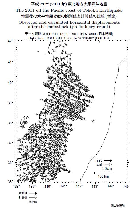
9 Crustal deformation and estimated distribution of slip on the plate boundary Slip model after GSI and JCG Moment magnitude =9.0 Maximum displacement =54m Horizontal and Vertical co-seismic displacement observed with GPS by GSI(on land) and JCG (on seabed)


10 ITRF reference stations
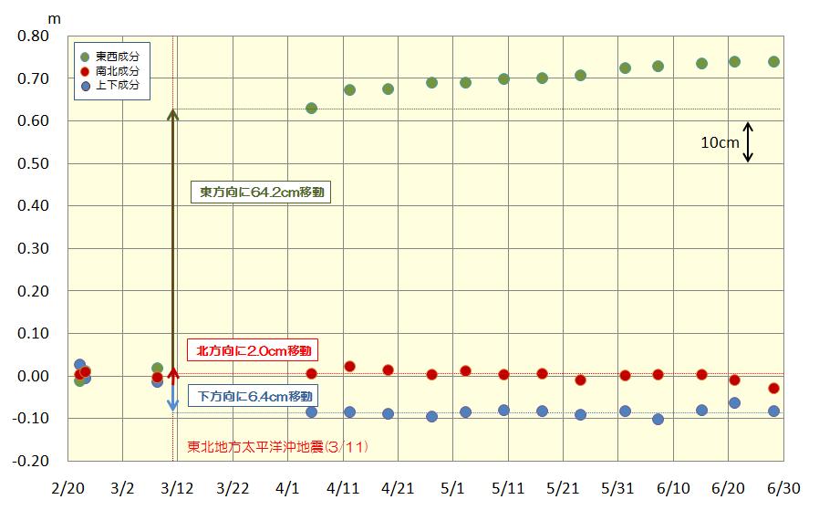

11 Displacement of Tsukuba VLBI station After GSI

12 Post-seismic slip After GSI

13 Displacement due to after effect After GSI
14 Geonet (Continuous GPS observation) Geospatial Information Authority of Japan (GSI) has released on May 31 New coordinate for new epoch and parameters for semi-dynamic correction
15 Geodetic control stations GSI has carried out resurvey of geodetic control stations in northern Japan New coordinates are released at the end of October, 2011 Ministry of Justice (MOJ) issued an official notice on March 18 that coordinates are to be temporally treated as local coordinates and at the same time, if surveyors can use control stations, note that so that later they can give official coordinates when GSI revised coordinates MOJ announced that people should be careful to date on map or certificate of map because those coordinates on such documents or maps will be corrected after GSI finishes their revision of coordinates of control stations.

16 Schematic model of crustal deformation and generation of Tsunami

17 Tsunami

18 Tide gauge record after Japan Coast Guard At Kamaishi: Scale out and broken 2 nd wave was the largest

19 Before the Earthquake after the Earthquake after NASA

20 Rikuzentakada from east
21 Challenges Most of buildings are lost Large horizontal displacement Streets and paths can be recognized

22 Rikuzenntakada from NW
23 Inside block are not well remained As streets are visible, if cadastral record is there, we can recover boundaries If modern cadastral survey was not yet finished, we may face a problem in finding boundary According to law, boundaries can not be created but found < In 1873, boundaries have been already officially set


24 Liquefaction Jetted sand After Urayasu City Lateral flow

25 Cadastre and Registration

26 Request of preservation of boundary marks by MOJ Just after the earthquake (March 24), MOJ issued press release asking people preserve boundary marks. The announcement was with picture of a real mark so that any one will recognize how it looks like.
27 Official notices issued by MOJ On March 24: Preservation of boundary monument in restoration work On March 29: When land certificate is lost by East Japan earthquake or tsunami On April 14: Treatment of request for preventing unjust registration of land
28 Guidance for surveyors and municipalities by MLIT On March 24: Administrative circular of assistant chief of division showing a guide line for immediate measure in carrying out cadastral survey on going at that time Followed by Q/A
29 Threat of power failure and counter measure Mainly due to tsunami, some of nuclear power plants stopped It caused insufficient power supply in wide area Eastern Japan and metropolitan area was in power alert (by virtue of power saving movement, actually no power failure occurred other than directly damaged area) Processing survey data need electric power => Some companies processed their data in safe area like Hokkaido
30
31 Land price: MLIT s Press release On August,1: MLIT issue press release stating that it will watch land price together with prefectural government According to National Land Use Planning Act, government can set area under land price surveillance when unusual rise in land price is a concern This action is to prevent unusual rise of land price due to people s preference in high lands
32 Measure taken by Head quarter for rehabilitation Creating special rehabilitation zone, Delivery of flexibly usable grant, Application of PPP, PFI and so on, Secure about 13 trilion yen for above measure, Action for rehabilitation such as Create new regional society corresponding to change in population structure General mobilization of hardware and software for reduction of damage Mechanism for swiftly realize reorganization of land use (including monitoring Land price and number of transactions) Assistance in human resources Rehabilitation will take 10 years and first 5 years are supposed to be period with intensified measure. Care for recovery from damage of Fukushima nuclear power plant is of course included.
33 Multifold defense against Tsunami Residential area Levee Commercial area Industrial area Agricultural area Use highway/railway embankment as 2 nd or 3 rd coastal levee High rise tsunami-shelter will be properly distributed in low land
34 Conclusion Crustal deformation caused by the earthquake is very much wide spread and large in magnitude Geodetic coordinates are to be revised by the end of October The transfer to new coordinates will smoothly be done when re-survey finishes (They are experienced) MOJ had already finished registered documents and maps digitized at the time of the earthquake and necessary data was practically bucked up
35 For future It will take long time in rehabilitation Long term plan is necessary but people must restore their daily life -> Where to compromise? Disaster resistant way of life is necessary Financial problem So much to do = we should keep our eyes on Eastern Japan -> Same for Haiti, Sumatra or other places
Establishing Efficient Cadastral Surveying Plan in Accordance with Introducing World Geodetic Reference System in Korea
 Modern Environmental Science and Engineering (ISSN 2333-2581) December 2015, Volume 1, No. 6, pp. 299-303 Doi: 10.15341/mese(2333-2581)/06.01.2015/003 Academic Star Publishing Company, 2015 www.academicstar.us
MnDOT Contract No Exhibit B. Scope of Work. Scope of Work
 MnDOT Contract No. 1032993 Contract General Description The purpose of this contract is to provide the State with the survey accurate re-establishment of designated Public Land Survey section boundaries
FLOODrisk rd European Conference on Flood Risk Management
 Possibilities of neighborhood evacuation within a district in the event of a large-scale flood in a low-lying area: A case study of Shinden district in Tokyo Hitoshi Nakamura 1,a 1 Shibaura Institute of
Learning from land suitability analysis and Dutch spatial policy for sustainable land use in Japan
 Learning from land suitability analysis and Dutch spatial policy for sustainable land use in Japan Toru Nagayama 22 January 2009 GIS Research Group Seminar, University of Tsukuba Highlights from : Nagayama.,
Directorate of Survey and Mapping NAMIBIA. Cadastral Information System. Vehupisa Kasuko Tjatindi Surveyor Directorate of Survey and Mapping NAMIBIA
 Vehupisa Kasuko Tjatindi Directorate of Survey and Mapping NAMIBIA Tel: +64 61 965000 Directorate of Survey and Mapping NAMIBIA Cadastral Information System Introduction Over the past few decades cadastral
ASPECTS OF A 3D CADASTRE IN THE NEW CITY OF MODI IN, ISRAEL
 ASPECTS OF A 3D CADASTRE IN THE NEW CITY OF MODI IN, ISRAEL ARMI GRINSTEIN Armi Grinstein - Geodetic Engineering Ltd. Israel ABSTRACT 3 Dimensional Cadastre is a relatively new sphere in property registration,
Ex-Ante Evaluation (for Japanese ODA Loan)
") Ex-Ante Evaluation (for Japanese ODA Loan) 1. Project name Country: Republic of the Union of Myanmar (Myanmar) Project name: Housing Finance Development Project L/A signing date: March 29, 2018 Approved
Ex-Ante Evaluation (for Japanese ODA Loan) 1. Project name Country: Republic of the Union of Myanmar (Myanmar) Project name: Housing Finance Development Project L/A signing date: March 29, 2018 Approved
The Readiness of the Trinidad and Tobago Cadastral System for Recovery from Disaster
 Presented at the FIG Working Week 2016, May 2-6, 2016 in Christchurch, New Zealand The Readiness of the Trinidad and Tobago Cadastral System for Recovery from Disaster Charisse GRIFFITH-CHARLES Trinidad
Implementation of a New Survey Control Standard for New Zealand
 Nic DONNELLY and Matt AMOS, New Zealand Key words: Geodesy, Reference Systems, Datum Maintenance, Standards, Geodetic Networks SUMMARY In September 2009 Land Information New Zealand promulgated a new standard
New Developments in the Hellenic Cadastre
 New Developments in the Hellenic Cadastre Prof. M. Kavouras Vice-president Ktimatologio S.A. (Hellenic Cadastre) The Hellenic Cadastre Background The Hellenic National Cadastre Organizational and institutional
LAND ISSUES AND GEO-INFORMATION: RESPONDING POST DISASTER EARTHQUAKES IN NEPAL
 LAND ISSUES AND GEO-INFORMATION: RESPONDING POST DISASTER EARTHQUAKES IN NEPAL ARBIND MAN TULADHAR FACULTY OF GEO-INFORMATION SCIENCE AND EARTH OBSERVATION (ITC), UNIVERSITY OF TWENTE, THE NETHERLANDS,
Shelter. International Recovery Platform (IRP) & Y. Shiozaki, Y. Tanaka, and A. Hokugo (Kobe University)
 & Y. Shiozaki, Y. Tanaka, and A. Hokugo (Kobe University)") Shelter International Recovery Platform (IRP) & Y. Shiozaki, Y. Tanaka, and A. Hokugo (Kobe University) 1 Flow of Housing Recovery Process Disaster Evacuation Shelter Usually municipal buildings, schools,
Shelter International Recovery Platform (IRP) & Y. Shiozaki, Y. Tanaka, and A. Hokugo (Kobe University) 1 Flow of Housing Recovery Process Disaster Evacuation Shelter Usually municipal buildings, schools,
Enhancement of quality of houses including earthquake resilience through financial assistance : Japanese experience. Masahiro Kobayashi
 World Bank-GFDRR March 17, 2016 Tokyo Disaster Risk Management Seminar No.8 "Building Regulation for Resilience: Managing Risks for Safer Cities Enhancement of quality of houses including earthquake resilience
Trimble Land Solutions -Transforming the way land
 Sanjeev Trehan Regional Manager - SAARC MARCH 2016 Trimble Land Solutions -Transforming the way land tenure is secured and land assets are managed. Government Opportunity Challenge Implementation of secure
PROJECT INFORMATION DOCUMENT (PID) APPRAISAL STAGE Report No.: PIDA Project Name. Region Country Sector(s) Theme(s)
 APPRAISAL STAGE Report No.: PIDA Project Name. Region Country Sector(s) Theme(s)") Public Disclosure Authorized Public Disclosure Authorized Public Disclosure Authorized Public Disclosure Authorized Project Name Region Country Sector(s) Theme(s) Lending Instrument Project ID Borrower(s)
Public Disclosure Authorized Public Disclosure Authorized Public Disclosure Authorized Public Disclosure Authorized Project Name Region Country Sector(s) Theme(s) Lending Instrument Project ID Borrower(s)
The Croatian Surveyor Guaranteeing Land Property
 Croatian Chamber of Chartered Geodetic Engineers Zagreb, Croatia www.hkoig.hr The Croatian Surveyor Guaranteeing Land Property Ph. D. Danko Markovinović The Cadastral Surveyor paving the Way to the Future
LADM in the Republic of Croatia making and testing country profile
 STATE GEODETIC ADMINISTRATION Gruška 20,10 000 Zagreb, Croatia LADM in the Republic of Croatia making and testing country profile Nikola Vučić Danko Markovinović Blaženka Mičević CONTENTS INTRODUCTION
Reconstruction in Haiti: A Land Rights Infrastructure to Support its Sustainable Development. Context in Haiti
 Reconstruction in Haiti: A Land Rights Infrastructure to Support its Sustainable Development Daniel Roberge Michel Paradis Mike Mora Sydney, Australia April 14 th 2010 Context in Haiti Haiti is the poorest
The Necessity for Interdisciplinary Cooperation as a Part of FIG Activity
 The Necessity for Interdisciplinary Cooperation as a Part of FIG Activity Joseph KRAUS, Joseph FORRAI, Israel Key words: interdisciplinary cooperation, surveyor s key role, surveyor s position SUMMARY
Application of tsunami modelling for escape and refuge planning in Aceh (Indonesia)
") Application of tsunami modelling for escape and refuge planning in Aceh (Indonesia) Odelinde Nieuwenhuis, DHV BV Deepak Vatvani, Deltares (Delft Hydraulics) Jeroen Alberts, DHV BV Dick Jansen, DHV BV May
Application of tsunami modelling for escape and refuge planning in Aceh (Indonesia) Odelinde Nieuwenhuis, DHV BV Deepak Vatvani, Deltares (Delft Hydraulics) Jeroen Alberts, DHV BV Dick Jansen, DHV BV May
Our policy of providing clients a personal service has been rewarded by a wide and diverse client base with high-level repeat commissions.
 1.0 Introduction Datum Surveying Consultants has professional, technical resources, equipment, experience and training to undertake any type of Survey and Mapping project expediently. Since inception in
General Instructions For Surveys and Plans Outside the Provincial Survey System
 May 15, 2018 General Instructions For Surveys and Plans Outside the Provincial Survey System NOTE: This document is a Controller of Surveys Policy manual to be used as a general guideline for the Legal
Addressing Land Sector Opportunities with Geospatial Information in Nepal
 The 20th UNRCC-AP and the 4th UN-GGIM-AP 5-10 October 2015 Jeju Island, Republic of Korea Addressing Land Sector Opportunities with Geospatial Information in Nepal Krishna Raj BC Executive Director Land
How a Cadaster Might Look Like in Finland in the Year 2035?
 How a Cadaster Might Look Like in Finland in the Year 2035? Mr. MARKKU Eino Olavi MARKKULA, Finland Key words; Cadastre, Coordinates, Digitised Process, Key Registers, Land Register Summary The Finnish
Republic of Bulgaria
 Geodesy, Cartography and Cadastre Agency Republic of Bulgaria www.cadastre.bg 24. 01. 2018 г., гр. София The Cadastre Legislation in Bulgaria - historical reference 1908 г. The Cadastre Act The objective
Slovenian Experiences
 Slovenian Experiences An example from a transition country Milan Brajnik, B.Sc.Geod., Assistant Director milan.brajnik@geod-is.si Geodetic Institute of Slovenia 1000 Ljubljana, Jamova cesta 2 The Identity
Mission Planning for a GPS Control Survey Using ESRI ArcMap. August 8, 2004 Mickie Warwick, PLS
 Mission Planning for a GPS Control Survey Using ESRI ArcMap August 8, 2004 Mickie Warwick, PLS Using ArcMap for GPS Mission Planning Surveyors are not tapping into the benefits that can be derived from
Occupants: Behaviour in Response to the High-rise Apartments Fire in Hiroshima City
 FIRE AND MATERIALS Fire. Mater. 23, 297}303 (1999) Occupants: Behaviour in Response to the High-rise Apartments Fire in Hiroshima City A. Sekizawa *, M. Ebihara, H. Notake, K. Kubota, M. Nakano, Y. Ohmiya,
Geodetic Infrastructure in Samoa. FIG Pacific Small Islands Developing States Symposium September 2013, Suva, FIJI.
 Geodetic Infrastructure in Samoa. FIG Pacific Small Islands Developing States Symposium 18 20 September 2013, Suva, FIJI. FIG Commission 5 Position and Measurement United Nations Global Geospatial Information
PROJECT INFORMATION DOCUMENT (PID) CONCEPT STAGE Report No.: AB3229 Project Name. Land Registry and Cadastre Modernization Project Region
 CONCEPT STAGE Report No.: AB3229 Project Name. Land Registry and Cadastre Modernization Project Region") PROJECT INFORMATION DOCUMENT (PID) CONCEPT STAGE Report No.: AB3229 Project Name Land Registry and Cadastre Modernization Project Region EUROPE AND CENTRAL ASIA Sector Central government administration
PROJECT INFORMATION DOCUMENT (PID) CONCEPT STAGE Report No.: AB3229 Project Name Land Registry and Cadastre Modernization Project Region EUROPE AND CENTRAL ASIA Sector Central government administration
Use of data in Ukraine for sustainable economic growth. Oleksandr Maliuk State Service of Ukraine for Geodesy, Cartography and Cadastre
 Use of data in Ukraine for sustainable economic growth Oleksandr Maliuk State Service of Ukraine for Geodesy, Cartography and Cadastre Kehl, 2017 Content of the presentation Ukraine & StateGeoCadastre:
Managing the dynamics of the New Zealand spatial cadastre
 Managing the dynamics of the New Zealand spatial cadastre Don Grant School of Mathematical & Geospatial Sciences, RMIT University, GPO Box 2476, Melbourne 3001, AUSTRALIA donald.grant@rmit.edu.au Chris
Profile of Dr. Shigeru MORICHI
 Profile of Dr. Shigeru MORICHI 1. Date and Place of Birth: Date of Birth: Sep. 29, 1943 Place of Birth: Kyoto City 2. Nationality: Japanese 3. Present Position: Senior Professor, National Graduate Institute
D DAVID PUBLISHING. Mass Valuation and the Implementation Necessity of GIS (Geographic Information System) in Albania
 in Albania") Journal of Civil Engineering and Architecture 9 (2015) 1506-1512 doi: 10.17265/1934-7359/2015.12.012 D DAVID PUBLISHING Mass Valuation and the Implementation Necessity of GIS (Geographic Elfrida Shehu
Journal of Civil Engineering and Architecture 9 (2015) 1506-1512 doi: 10.17265/1934-7359/2015.12.012 D DAVID PUBLISHING Mass Valuation and the Implementation Necessity of GIS (Geographic Elfrida Shehu
Land Improvement Act
 Issuer: Riigikogu Type: act In force from: 01.09.2015 In force until: 31.12.2017 Translation published: 04.09.2015 Amended by the following acts Passed 22.01.2003 RT I 2003, 15, 84 Entry into force 01.07.2003,
DISASTER RELIEF AS MONUMENT
 In Christchurch, New Zealand, an innovative and symbolic structure designed by Pritzker Prize-winning architect Shigeru Ban has just taken shape: a Cardboard Cathedral to stand in for the historic building
Classification of Licensed Surveyors
 Classification of Licensed Surveyors Joseph FORRAI, Gili KIRSCHNER, Michael KLEBANOV and Rozet SHAKED, Israel Key words: Survey of Israel, licensed surveyor, classification, cadastre, mutation plan SUMMARY
CHAPTER 5 FLOOD DAMAGE PREVENTION. Statutory Authorization, Findings of Fact, Purpose, Methods, and Definitions
 CHAPTER 5 FLOOD DAMAGE PREVENTION Article A. Section 5.1 Section 5.2 Section 5.3 Section 5.4 Section 5.5 Article B. Statutory Authorization, Findings of Fact, Purpose, Methods, and Definitions Statutory
Project Management Forum. Eilat 2009
 Project Management Forum Eilat 2009 May 2009 FIG Working Week 1 Purpose To build on the sessions in Hong Kong and Stockholm To review the elements of PM To review examples of the stages of development
Notice Concerning Property Acquisition
 [For Translation Purposes Only] April 25, 2017 Nomura Real Estate Master Fund, Inc. Securities Code: 3462 Satoshi Yanagita, Executive Director Asset Management Company: Nomura Real Estate Asset Management
BULGARIAN CADASTRE A GUARANTEE FOR THE OWNERSHIP RIGHTS IN IMMOVABLE PROPERTIES
 4 TH INTERNATIONAL CONFERENCE RECENT PROBLEMS IN GEODESY AND RELATED FIELDS WITH INTERNATIONAL IMPORTANCE February 28 - March 2, 2007, Inter Expo Centre, Sofia, Bulgaria BULGARIAN CADASTRE A GUARANTEE
Land Readjustment and Post-Disaster Reconstruction in Japan
 Land Readjustment and Post-Disaster Reconstruction in Japan Norihiko Yanase To begin the chapter, it is important to start by defining key terms. Rehabilitation ( 復旧 fukkyu) means the disaster response
Ⅱ-2. The Resurvey Project
 Presenter : JANG, Bong-Bae MLTM Ministry of land,transport and Maritime Affairs KIM, Soon-Tae KCSC Korea Cadastral Survey Corp., JANG, Bong-Bae Ⅰ. INTRODUCTION The Korean modern cadastral system was established
Methodology of JRPPI: Japan Residential Property Price Index
 Methodology of JRPPI: Japan Residential Property Price Index March 2016 Land Economy and Construction Industries Bureau Ministry of Land, Infrastructure, Transport and Tourism Contents 1. Outline of the
OF CHANGE IN SHEAR WALL LOCATION ON STOREY DRIFT OF MULTISTOREY BUILDING SUBJECTED TO LATERAL LOADS
 EFFECT OF CHANGE IN SHEAR WALL LOCATION ON STOREY DRIFT OF MULTISTOREY BUILDING SUBJECTED TO LATERAL LOADS AshishS.Agrawal*, S.D.Charkha** *Post Graduate Student in Structural Engineering, Babasaheb College
New Cadastral Mapping in the Czech Republic
 New Cadastral Mapping in the Czech Republic Karel Štencel, Svatava Dokoupilová, Jan Kmínek Czech Office for Surveying, Mapping and Cadastre Basic Data about the Czech Republic Area: 78 866 km 2 Population:
The Characteristics of Land Readjustment Systems in Japan, Thailand, and Mongolia and an Evaluation of the Applicability to Developing Countries
 ISCP2014 Hanoi, Vietnam Proceedings of International Symposium on City Planning 2014 The Characteristics of Land Readjustment Systems in Japan, Thailand, and Mongolia and an Evaluation of the Applicability
Development of Mobile Cadastral Surveying System for Korean Cadastral Resurvey Project
 Development of Mobile Cadastral Surveying System for Korean Cadastral Resurvey Project Joon-Sik, KIM, Sang-Gu, KANG, Yun-Soo, CHOI, Republic of Korea Key words: Mobile Cadastral Surveying System, RTK-GPS,
Development of Cadastral Survey and Land Ownership Registration System in Mongolia
 Development of Cadastral Survey and Land Ownership Registration System in Mongolia M.Saandar,, Ph. D Vice President, the Mongolian Association of Surveying and Mapping, ( As National Member of FIG ) MonMap
Participants of the Ministerial Meeting on Housing and Land Management on 8 October 2013 in Geneva
 Summary At its meeting on 2 April 2012, the Bureau of the Committee on Housing and Land Management of the United Nations Economic Commission for Europe agreed on the need for a Strategy for Sustainable
Notice Concerning Property Disposition
 [For Translation Purposes Only] For Immediate Release To Whom It May Concern January 15, 2019 Notice Concerning Property Disposition Nomura Real Estate Master Fund, Inc. Securities Code: 3462 Shuhei Yoshida,
Well Survey Requirements
 Well Survey Requirements Directive PNG003 November 2015 Revision 1.0 Governing Legislation: Act: The Oil and Gas Conservation Act Regulation: The Oil and Gas Conservation Regulations, 2012 Record of Change
Japan Country Report April 2013 at Singapore
 Japan Country Report 18-20 April 2013 at Singapore Monthly Report(MAR2013) by Japanese Government Japanese economy is showing movement of picking up recently, while weakness can be seen in some area. Exports
EARTHQUAKES IN ALASKA December 2005 ALASKA EARTHQUAKE INFORMATION CENTER
 EARTHQUAKES IN ALASKA December 2005 ALASKA EARTHQUAKE INFORMATION CENTER A report of the Alaska State Seismologist s Office Alaska Earthquake Information Center Geophysical Institute, University of Alaska
PCC Conference and Plenary Meeting "Data as a basis of the digital society March 2018, Sofia. Activity of the geodetic NGOs in Bulgaria
 PCC Conference and Plenary Meeting "Data as a basis of the digital society 13-15 March 2018, Sofia Activity of the geodetic NGOs in Bulgaria Union of Surveyors and Land Managers in Bulgaria Chamber of
FLOOD HAZARD AREA LAND USE MANAGEMENT
 FLOOD HAZARD AREA LAND USE MANAGEMENT Introduction Guidance For Selection of Qualified Professionals and Preparation of Flood Hazard Assessment Reports This document is intended to provide guidance for
New Danish e-cadastre and its role in the Danish e-government
 New Danish e-cadastre and its role in the Danish e-government PCC Budapest 2011 Pia Dahl Højgaard, pdh@kms.dk Cadastre and Legal Authority, National Survey and Mapping, Denmark The danish context Neighbours
Japan Country Report 3-12at Cambodia
 Japan Country Report 3-12at Cambodia The big earthquake and tsunami in east Japan Magnit ude Damag e Death toll(th ousand ) Destro yed Houses Nation al Debt (Again st GDP) Charac ter of Area East Japan
Land Administration System in Russian Federation
 Sergey VOLKOV, Russia Key words: land administration, market economy, land management, land resources. SUMMARY Principle source of economic and social development of Russian Federation in XXI century will
On the Rights of Landowners to Compensation for Restrictions on Economic Activities in Specially Protected Nature Territories and Microreserves
 Disclaimer: The English language text below is provided by the Translation and Terminology Centre for information only; it confers no rights and imposes no obligations separate from those conferred or
THE DEVELOPMENT AND CHARACTERISTICS OF THE MODERN CADASTRAL EDUCATION IN KOREA
 THE DEVELOPMENT AND CHARACTERISTICS OF THE MODERN CADASTRAL EDUCATION IN KOREA Jongduck JI and Hwanzong YU, Korea Key words: cadastral education, cadastral course, curriculum, computerization. 1. INTRODUCTION
Resettlement Policy framework for the Albania s Improvement of the Management and Conditions of the Secondary and Local Roads Project
 Resettlement Policy framework for the Albania s Improvement of the Management and Conditions of the Secondary and Local Roads Project I. Introduction The overall length of the road network in Albania totals
Question 7: Titles in and adjacent to the marine and coastal area
 19 October 2010 Māori Affairs Committee Marine and Coastal Area (Takutai Moana) Bill Question 7: Titles in and adjacent to the marine and coastal area On 13 October, the Committee asked for: Advice on
Land Administration In Public Private Partnerships
 Land Administration In Public Private Partnerships Workshop Customers - Co-operation - Services Vienna, 12-13 September 2002 Peter Creuzer Content Land Administration - Tasks History Spatial Data Infrastructure
In the context of a Major Disaster, this revenue procedure provides temporary
 CASE MIS No.: RP-141793-11 Administrative, Procedural, and Miscellaneous 26 CFR 601.105: Examination of returns and claims for refund, credit, or abatement; determination of correct tax liability. (Also:
Keith Clifford Bell EASER. December 15, 2010 pm MC2-800 ; 12:30-2:30
 Keith Clifford Bell EASER December 15, 2010 pm MC2-800 ; 12:30-2:30 The context and challenges. Interventions in Aceh land sector. RALAS. Study Gender Impacts of Land Titling in Aceh. Considerations for
A Business Owner s Survival Guide to Eminent Domain. 10 Things You Must Know When the Government Wants to Condemn Property
 A Business Owner s Survival Guide to Eminent Domain 10 Things You Must Know When the Government Wants to Condemn Property nossaman.com/eminentdomain What is Eminent Domain and What are My Rights as a Business
HOUSING AND PROPERTY MARKET IN LITHUANIA CONTENTS
 HOUSING AND PROPERTY MARKET IN LITHUANIA Kęstutis Sabaliauskas, Director General State Enterprise Centre of Registers, Lithuania Kestutis.Sabaliauskas@registrucentras.lt CONTENTS Legal environment Real
Land Administration Infrastructures for Sustainable Development
 The Global Challenges Land Administration Infrastructures for Sustainable Development Prof. Stig Enemark Department of Development and Planning Aalborg, University, Denmark INTERNATIONAL CONFERENCE ON
Challenges to Effective Land Governance in Trinidad and Tobago
 Charisse GRIFFITH-CHARLES, Trinidad and Tobago Key words: land administration, land governance SUMMARY Various technological and legislative solutions present themselves to alleviate land governance issues.
Name of World Heritage property State Party ID number Old Walled City of Shibam Republic of Yemen C 192
 Name of World Heritage property State Party ID number Old Walled City of Shibam Republic of Yemen C 192 STATE PARTY S REPORT ON THE STATE OF CONSERVATION OF OLD WALLED CITY OF SHIBAM, YEMEN INSCRIBED ON
LAW ON EXPROPRIATION (Official Gazette of the Republic of Montenegro, No 55/00, 12/02, 28/06)
") LAW ON EXPROPRIATION (Official Gazette of the Republic of Montenegro, No 55/00, 12/02, 28/06) I Basic Provisions Expropriation of Immovables Article 1 Expropriation shall mean dispossession or limitation
LAW ON EXPROPRIATION (Official Gazette of the Republic of Montenegro, No 55/00, 12/02, 28/06) I Basic Provisions Expropriation of Immovables Article 1 Expropriation shall mean dispossession or limitation
PANAFRICA GEOINFORMATION SERVICES PLC ETHIOPIA
 PANAFRICA GEOINFORMATION SERVICES PLC ETHIOPIA Tenets PanafricaGIS is a technology-enthusiast company operated by experienced professionals in the field of geo-information. We believe a sustained and inclusive
Cadastre: definitions
 Introduction New vision towards a multipurpose cadastral system to support land management in Morocco Moha EL-AYACHI, El Hassane SEMLALI, Mohamed ETTARID, Driss TAHIRI, Institut Agronomique et Vétérinaire
TAX ALERT. Master tenant HTC transactions: IRS treatment of 50(d) income
 income") AUG. 2, 2016 Mark Snider 614.227.2510 msnider@porterwright.com Master tenant HTC transactions: IRS treatment of 50(d) income Dave Tumen 614.227.2260 dtumen@porterwright.com The historic tax credit industry
AUG. 2, 2016 Mark Snider 614.227.2510 msnider@porterwright.com Master tenant HTC transactions: IRS treatment of 50(d) income Dave Tumen 614.227.2260 dtumen@porterwright.com The historic tax credit industry
VI. SAFETY ELEMENT I. INTRODUCTION A. PURPOSE B. AUTHORITY. 1. Safety
 AB 162 and SB 1241 Amendment to the Safety Element New sections are underlined, deleted sections are shown as strikethrough and the denotes text remaining in place. VI. SAFETY ELEMENT I. INTRODUCTION A.
Implementation of Fit for Purpose Land Administration in Nepal, in a post disaster context.
 Implementation of Fit for Purpose Land Administration in Nepal, in a post disaster context. Paula Dijkstra, Raja Ram Chhatkuli, Danilo Antonio, Eva-Maria Unger, Chrit Lemmen Wondimagegm Tesfaye, Shristee
Institute of Cadastral Surveying (Inc)
") Institute of Cadastral Surveying (Inc) RO. Box 775, Timaru Ph. & Fax: (03) 686 9400 Email: sec@ics.org.nz Web: www.ics.org.nz Page 1 6 May 2010 COMPLAINT ABOUT THE SURVEYOR GENERAL'S RULES FOR CADASTRAL
Institute of Cadastral Surveying (Inc) RO. Box 775, Timaru Ph. & Fax: (03) 686 9400 Email: sec@ics.org.nz Web: www.ics.org.nz Page 1 6 May 2010 COMPLAINT ABOUT THE SURVEYOR GENERAL'S RULES FOR CADASTRAL
Land Tenure and Geospatial Data and Technology
 Land Tenure and Geospatial Data and Technology Ioana Bouvier E3/Land and Urban, USAID Senior Geospatial Analyst January 23, 2018 January 23, 2018 1 OUTLINE 1. Overview of geospatial data and technology
The Use of Cadastral Information in Projects Financed by the EU: The Hellenic Cadastre
 The Use of Cadastral Information in Projects Financed by the EU: The Hellenic Cadastre Prof. D. Balodimos Vice-President of Ktimatologio S.A. (Hellenic Cadastre) Acknowledgements Dr. Panos Lolonis, Coordinator
The Role of Geodesy in Modernization of Croatian Railways
 Igor POLJANAC, Rinaldo PAAR and Vlado CETL, Croatia Key words: railways, modernization, infrastructure, and geodesy. SUMMARY At the beginning of the 90-s in the last century the changes in the economic
Establishment of a land market in Ukraine: current state and prospects
 Establishment of a land market in Ukraine: current state and prospects More than 25 years have passed since the adoption of the first resolution of the Verkhovna Rada On Land Reform. Despite such a long
emergency shelter options For Cyclone Aila
 emergency shelter options For Cyclone Aila Glimpses of Aila affected community People taking shelter on the embankment (Gabura, Syamnagar) People taking shelter on the embankment (Dacop) An affected family
Designing for transparency and participation in the Hellenic Cadastral Project
 Designing for transparency and participation in the Hellenic Cadastral Project Dr. Dimitris Rokos Director of Planning and Investments, Hellenic National Cadastre and Mapping Agency S.A. Table of Contents
FUTURE VISION ON KOREAN CADASTRAL SURVEYING
 FUTURE VISION ON KOREAN CADASTRAL SURVEYING Myounwoo LEE, Vice President, Korea Cadastral Survey Corporation, Korea 1. INTRODUCTION Cadastral surveying, which contributes to secure the ownership of the
250 CMR: BOARD OF REGISTRATION OF PROFESSIONAL ENGINEERS AND LAND SURVEYORS DRAFT FOR DISCUSSION PURPOSES ONLY
 250 CMR 6.00: LAND SURVEYING PROCEDURES AND STANDARDS Section 6.01: Elements Common to All Survey Works 6.02: Survey Works of Lines Affecting Property Rights All land surveying work is considered work
SHALE GAS. April 2013
 SHALE GAS If the commercial exploitation of shale gas takes off in the UK, given the vast areas of land likely to be affected, property processionals will be engaged at every level. Jonathan Small QC considers
RECONSTRUCTION OF LAND ADMINISTRATION SYSTEM IN NANGGROE ACEH DARUSSALAM (NAD) AND NIAS
 AND NIAS") RECONSTRUCTION OF LAND ADMINISTRATION SYSTEM IN NANGGROE ACEH DARUSSALAM (NAD) AND NIAS Joyo WINOTO, Indonesia Key words: Tsunami; Land Administration; Land Rights Protection; Community Driven Adjudication
RECONSTRUCTION OF LAND ADMINISTRATION SYSTEM IN NANGGROE ACEH DARUSSALAM (NAD) AND NIAS Joyo WINOTO, Indonesia Key words: Tsunami; Land Administration; Land Rights Protection; Community Driven Adjudication
A Geocoded Cadastral Fabric as a Precondition for a Sustainable Land Management System
 A Geocoded Fabric as a Precondition for a Sustainable Land Management System Gottfried KONECNY, Germany; J.P. LAUZON, Canada; Abdul Salam MOHAMMED, India Key words: SDI,, Parcel Boundaries, GPS-GNSS, Land
The Hellenic National Cadastre: An elemental institution for nurturing and promoting innovation in 3D geospatial data
 Hellenic National Cadastre: An elemental institution for nurturing and promoting innovation in 3D geospatial data Professor Byron Nakos President NATIONAL CADASTRE AND MAPPING AGENCY SA (NCMA SA) 288 Mesogion
TERMS AND CONDITIONS OF PUBLIC ONLINE AUCTION
 TERMS AND CONDITIONS OF PUBLIC ONLINE AUCTION Pursuant to the State Assets Act and the Regulation no 14 of 28 April 2010 of the Minister of the Environment Procedure for the Grant of Use and Selling of
Property Based Land Information Systems of Turkey
 Property Based Land Information Systems of Turkey Mehmet Fatih DİRİ, Bilgehan ÖZSOY, Ünsal ERGÜN, Turkey Key words: Cadaster, Land Registry, GIS, Property, TURKEY SUMMARY The property, addition to the
Annual Meeting 2006 SLOVENIA, BLED RASAS GOFMANAS JAUNIUS GRIGAS RIMANTAS RAMANAUSKAS KESTUTIS TRECIOKAS
 Annual Meeting 2006 SLOVENIA, BLED LAND ADMINISTRATION IN LITHUANIA RASAS GOFMANAS JAUNIUS GRIGAS RIMANTAS RAMANAUSKAS KESTUTIS TRECIOKAS ADMINISTRATIVE STRUCTURE OF LITHUANIA HISTORY OF LAND ADMINISTRATION
North Carolina/South Carolina Boundary Clarification
 North Carolina/South Carolina Boundary Clarification JASON.BRANHAM@BROCKANDSCOTT.COM Background 1735: Original boundary between the two British provinces agreed upon then approved by Crown - From specific
California-Specific Professional Land Surveyor Examination Test Plan
 General Definition of California Professional Land Surveying Practices: The practice of land surveying in the State of California consists of determining, establishing, reporting and mapping the positions,
International funding projects in Republic Geodetic Authority
 International funding projects in Republic Geodetic Authority Serbia: Republic Geodetic Authority Workshop Exploring Funding Instruments for NMCA 7-8 November 2012 Republic Geodetic Authority Republic
Spatially Enabled Society Role of the Cadastre
 armasuisse Bundesamt für Landestopografie swisstopo Swiss Federal Directorate for Cadastral Surveying Spatially Enabled Society Role of the Cadastre XXIV FIG International Congress 2010 FIG-Task Force
TSO1C: Land Reforms. Commission 7
 TSO1C: Land Reforms. Commission 7 Development of & Implementation LIS. Building an effective Partnership to Reform Uganda s Land Administration (7320) Gasant Jacobs, Head: Business Development. Tax & Accounting
FIG Congress 2010 Facing the Challenges Building the Capacity Sydney, Australia, April
 Setting up the infrastructure for improving the development of Cadastre in Greece Dr. Dimitris ROKOS, Dr. Konstantinos KYRIAZIS and Dr. Panos LOLONIS KTIMATOLOGIO S.A. (Hellenic Cadastre) Source: wikipedia
Establishing a Land policy reform and GPS Technology implementation in Burkina Faso
 Annual World Bank Conference on Land and Poverty 2013 Establishing a Land policy reform and GPS Technology implementation in Burkina Faso Presentation made by Moha EL-AYACHI, IAV Hassan 2, Morocco Paper