Copernicus Land Monitoring Service (Pan- European and Local) in the Netherlands
|
|
|
- Jasmine Holmes
- 5 years ago
- Views:
Transcription

 in the")

")
1 Copernicus Land Monitoring Service (Pan- European and Local) in the Netherlands Wageningen Environmental Research (WENR) activiteiten 13 Juni 2018, Gerard Hazeu
2 Introduction Personal note and some terminology (EIONET, NRC, EAGLE) WENR EEA, EIONET, NRC-LC, EAGLE National activities NL focus: Landelijk Grondgebruik Nederland, Basiskaart Natuur, Groenmonitor... European focus (CLMS) Framework Service contract Other service contracts EAGLE CLC-plus 2
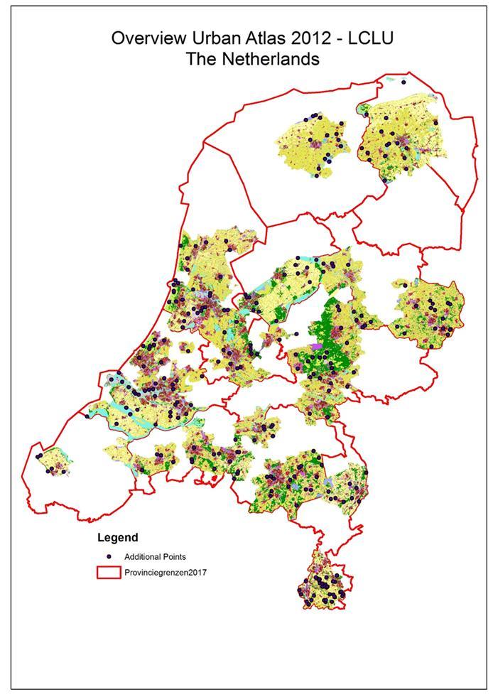
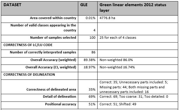
3 Framework Service Contract (1) FSC for the Copernicus Land monitoring services NRCs LC) Copernicus supporting activities for the period CLC2018 Production of CLC2018 Production of CLC2012revised Production of CLC-change Verification Local Components Urban Atlas (UA) 2012 status layer Urban Atlas 2012 Street Tree Layer (STL) Riparian Zones LCLU 2012 status layer (RZ) Riparian Zones Green Linear Elements 2012 status layer (GLE) 3


 standard legend: hierarchical")
 classes geometric accuracy is 100 m,")
4 Background CLC production in NL CLC versions 1990, 2000, 2006, 2012 and 2018 Methodological development in time (analogue - digital) Focus on monitoring changes in harmonised way over Europe Specifications: MMU is 25 ha (CLC) and 5ha (CLCchanges) standard legend: hierarchical with 44 (3th level), 15 (2nd level), 5 (1st level) classes geometric accuracy is 100 m, thematic accuracy: 85% 4

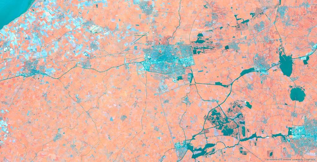

5 Example of CLC2018 production 5


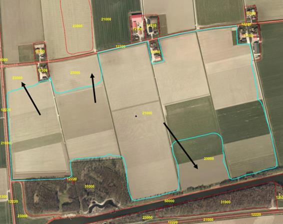

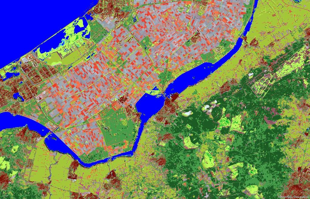
6 Example of Local Component Verification (1) 6

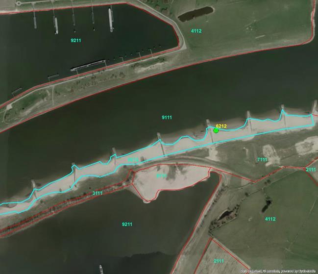

7 Example of Local Component Verification (2) 7
8 Framework Service Contract (2) Enrichment Urban Atlas (probably class 121 industrial etc.) Post-production verification of the High Resolution Layers (HRLs) for the 2015 reference year. Imperviousness Forest Grassland Wetness & Water Small woody features Dissemination national products 8
9 9
10 Framework Service Contract (3) Future Verification and enrichment activities related to an upcoming coastal zone product. Post-production verification of the HRLs for the 2018 reference year. Support and testing of future CLC+ (2nd generation CLC methodological improvements and developments), based on CLC2018 products 10
11 Other Copernicus contracts Specifications for Copernicus land products Specifications HRL (e.g. Water and wetness, Grasslands and Small and Woody Features (SWF)) Analyse the possibilities for moving from 3 or 6 yearly snapshots into yearly partial incremental updates of land monitoring products, including the assessment of changes required in workflows EAGLE contracts EAGLE data model Towards CLC plus 11
12 EAGLE EAGLE EIONET Action Group on Land monitoring in Europe EIONET European Environment Information and Observation Network Group of NRC s (National Reference Centres) for Land Cover Most active countries: Austria, Finland, Germany, Hungary, Luxembourg, Netherlands, Norway, Portugal, Spain Objective goal: A European land monitoring system fitting with todays needs Streamlining national and European land cover activities (efficiency, bottomup/top-down) 12
13 EAGLE data model Criteria: separation LU/LC, object oriented, scale independent, backwards compatible, applicable on national/eu level, temporal phenomena Landscape description Land Cover Components (Water, Biotic, Abiotic) Land Use Attributes (agriculture, mining, transportation...) Characteristics (cultivation measures, status/condition...) Applicability: Semantic comparison of definitions of classes Guideline of descriptive characterization of landscape 13

14 C o n c e p t u a l d e s i g n C L C + Land Monitoring These are working names and not fixed. Multi-stage process Multiple products Different production philosophies Different resource models Industrial and Member State involvement

15 Land Monitoring K e y c h a r a c t e r i s t i c s f o r t h e f o u r e l e m e n t s o f 2 nd g e n e r a t i o n C L C
16 I n v o l v e m e n t o f M e m b e r S t a t e s Land Monitoring Input to and review of the conceptual framework and technical specifications. Support to population of thematic information in CLC-Core. Change mapping. Member State benefits CLC-Backbone aligned to national / local mapping requirements Access to information rich CLC-Core CLC+ contributes to national reporting
17 National considerations CLC+ Needs, Plans, Gaps, Expectations Derive national LC/LU dataset LGN from CLC+ or derive CLC+ from LGN/national data Detailed LC/LU change mapping (type of change) -> monitoring Limited number of datasets available regarding EAGLE land cover components Increase in temporal frequency and spatial detail Complete integration of LPIS data in CLC+ algorithms to derive CLC classes and CLC traditional geometry from CLC-core (and/or national data) 17
18 Final remarks Development land services (products, temporal dimension, spatial detail, time horizon) Integration/fine-tuning Dutch and European land activities Support Dutch government to European activities LC/LU data as key dataset basis registratie European and Dutch dissemination Increase awareness of services Insight in use and +/- of services National and/or European products/projections Long term solution needed for (maintenance webservices, metadata etc) 18

19 Thanks! 19
 LU Attributes (HILUCS) ABIOTIC LCCs (Artificial/Natural) CH Characteristics BIOTIC LCCs (Vegetation) 20 CH -.")
20 E A G L E d a t a m o d e l Land Monitoring CH LC Unit (1..* LCCs) LU Attributes (HILUCS) ABIOTIC LCCs (Artificial/Natural) CH Characteristics BIOTIC LCCs (Vegetation) 20 CH WATER LCCs CH
21 To w a r d s C L C + o r s e c o n d g e n e r a t i o n C L C Land Monitoring Driven by DG GROW, EEA & EIONET Member States. Industrial production by service providers Vector product Highly automated Short timeframe Driven by EO (Sentinel-2) Firmly grounded within Copernicus and the Copernicus Land Monitoring Service (local components) Land domain represents probably the most diversified area of activity within the Copernicus programme. LULC under pins a broad range of uses and applications. Stakeholder contributions of requirements and opinions are vital for the success and the longterm development of land monitoring in Europe. Multi-stage process, multiple products, industry and MS involved
22 I s s u e s w i t h C L C Land Monitoring A number of deficiencies and limitations restrict wider exploitation at the Member State level and below. MMU of CLC (25 ha) is too coarse to capture fine spatial details. Mixed thematic classes with broad definitions difficult to interpret. Not sufficient thematic details or attribution. Many changes smaller 5 ha of the CLC change layer. 6-yearly update too slow for community policy needs. Dynamic landscape features, which are highly relevant to policy, may be missed or underestimated.
23 R e q u i r e m e n t s r e v i e w Land Monitoring Review: Key European policy requirements (e.g. Land Use, Land Use Change and Forestry (LULUCF) Additional policy requirements (e.g. EU Biodiversity Strategy to 2020, Mapping and Assessment of Ecosystems and their Services (MAES)) EIONET members Summary of requirements review MMU 0.5 to 5 ha, 0.5 ha for LULUCF Change layer MMU = status layer MMU Revised thematic content (more classes, increased characterisation) 3 year to yearly update cycle Pan-European coverage (EEA-39)


24 C L C - B a c k b o n e ( 1 ) Land Monitoring Outline: Wall-to-wall coverage (EEA-39) Complete the picture started by the LoCo which cover less than one third of EEA-39. Spatially detailed, large scale Vector format Based on digital cartography and EO Limited, but robust thematic detail Geometric backbone/skeleton Basic land cover inventory to support other products
 Land")

25 C L C - B a c k b o n e ( 2 ) Land Monitoring Example using UK Land Cover Map
26 C L C - C o r e ( 1 ) Land Monitoring Outline: Next stage of development after CLC-Backbone A consistent, multi-use repository for environmental information Grid database with EAGLE data model Populated with a broad range of land cover, land use and ancillary data, forming the information CLMS and external sources MS contribution (land use, habitats, etc.) Engine to deliver tailored thematic information.


27 C L C - C o r e ( 2 ) Land Monitoring Spatial domain EAGLE Data Model Source: CSU,
28 C L C + Land Monitoring Outline: End point for this exercise An improved LULC monitoring product Addressing a broad range of requirements Based on CLC-Core, which is built on CLC-Backbone, the local components and HRLs. Improved spatial detail relative to CLC Improved thematic content relative to CLC

29 C L C - L e g a c y Land Monitoring Conventional CLC Must be back compatible Link into CLC-Core and CLC+ Potential improvements to attribution
INSPIRE Thematic Working. Cadastral parcels. September 2008
 INSPIRE Thematic Working Cadastral parcels September 2008 The INSPIRE context The INSPIRE Directive Its aim is to build the INfrastructure for Spatial InfoRmation in Europe The INSPIRE Directive has been
Cadastral Parcels in the context of INSPIRE
 Cadastral Parcels in the context of INSPIRE Gyula IVÁN Institute of Geodesy, Cartography & Remote Sensing, HUNGARY Open Symposium on Environment and Land Administration Big Works for the Defence of Territory
Cadastral Parcels in INSPIRE. Lisbon, 27 February 2013
 Cadastral Parcels in INSPIRE Lisbon, 27 February 2013 Dominique.laurent@ign.fr Plan INSPIRE context The modeling approach for theme Cadastral Parcels Implementation of INSPIRE theme Cadastral Parcels Context
GMES Land Core Services Kiew, 26th November 2008
 GMES Fast Track Service Land GMES Land Core Services Kiew, 6th November 008 Alexander Kaptein ( coordinator) European Commission Fast Track Service Land within the GMES initiative in FP-7 consortium GMES
The Challenge to Implement International Cadastral Models Case Finland 1
 The Challenge to Implement International Cadastral Models Case Finland 1 Tarja MYLLYMÄKI and Tarja PYKÄLÄ, Finland Key words: cadastre, modelling, LADM, INSPIRE SUMMARY Efforts are currently made to develop
EduMapping + JobMapping
 EduMapping + JobMapping Frans Rip Centre for Geoinformation, Wageningen UR 18 April 2011 1. What is EduMapping? Present GI-course descriptions Toekomst: mèt etiket Assessment by teacher Course content
Copernicus Sentinels the game changer?
 Setting the workshop scene OTSC-data in IACS and its Copernicus alternatives Philippe Loudjani, Wim Devos, Pavel Milenov, Guido Lemoine, Csaba Wirnhardt, Pär Åstrand JRC D5 MARS CAPland Inter-service brainstorming
Recent development in land consolidation in Macedonia and land valuation issues
 Recent development in land consolidation in Macedonia and land valuation issues EMERALD(2008-2009)-Encouraging Macedonia s Endeavours to Rural Land Development and STIMERALD(2010-2012) Origin of Emerald
Challenge to Implement International Cadastral Models Case Finland
 FIG Articleof the Month April 20 Challenge to Implement International Cadastral Models Case Finland Tarja Myllymäki and Tarja Pykälä 200-04-5 The topics are In European level INSPIRE Experiences, similarities,
Report and update from Working Group A on Core Data
 JOINT UN-GGIM: EUROPE ESS MEETING ON THE INTEGRATION OF STATISTICAL AND GEOSPATIAL INFORMATION LUXEMBOURG 31 MARCH 2017 Report and update from Working Group A on Core Data François Chirié, Dominique Laurent,
The ISO/TC 211 Land Administration Domain Model (LADM)
") Geographic information/geomatics The ISO/TC 211 Land Administration Domain Model (LADM) Harry Uitermark/Editor LADM Kadaster/ITC, The Netherlands International Organization for Standardization (ISO) A
Geographic information/geomatics The ISO/TC 211 Land Administration Domain Model (LADM) Harry Uitermark/Editor LADM Kadaster/ITC, The Netherlands International Organization for Standardization (ISO) A
A Review and Perspective on Parcel Data Models for Urban Planning
 A Review and Perspective on Parcel Data Models for Urban Planning Yiqiang Ouyang Prof. Dr. Ilir Bejleri Department of Urban and Regional Planning University of Florida June 19-21, 2010 1 Content 1. Introduction
Unified Land Administration for a Better Spatial Infrastructure
 Unified Land Administration for a Better Spatial Infrastructure Gyula IVÁN Institute of Geodesy, Cartography & Remote Sensing FÖMI (HUNGARY) Open Symposium 30th Korean Cadastral Seminar & FIG Commission
Upcoming opportunities in FP 7 SPACE and GIO. NEREUS Workshop Brussels, 7 Nov Dr. Thomas Geist
 Upcoming opportunities in FP 7 SPACE and GIO NEREUS Workshop Brussels, 7 Nov 2011 Dr. Thomas Geist Outline GMES Initial Operations (GIO) WP 2012 and WP 2013 FP 7 SPACE WP 2013, last call JPIs Joint Programming
HELM. Harmonised European Land Monitoring
 HELM Harmonised European Land Monitoring HELM Harmonised European Land Monitoring Findings and Recommendations of the HELM Project This research project was carried out with the generous aid of the European
The Establishment of the Cadastral Parcel as a Core Element in the European SDI - Lessons Learned and View Towards Inspiring Applications.
 The Establishment of the Cadastral Parcel as a Core Element in the European SDI - Lessons Learned and View Towards Inspiring Applications. Amalia Velasco Martín-Varés 1, Martin Salzmann 2 1 Spanish Directorate
PROJECT INFORMATION DOCUMENT (PID) APPRAISAL STAGE Report No.: PIDA Project Name. Region Country Sector(s) Theme(s)
 APPRAISAL STAGE Report No.: PIDA Project Name. Region Country Sector(s) Theme(s)") Public Disclosure Authorized Public Disclosure Authorized Public Disclosure Authorized Public Disclosure Authorized Project Name Region Country Sector(s) Theme(s) Lending Instrument Project ID Borrower(s)
Public Disclosure Authorized Public Disclosure Authorized Public Disclosure Authorized Public Disclosure Authorized Project Name Region Country Sector(s) Theme(s) Lending Instrument Project ID Borrower(s)
GAUSSCAD A WEBGIS APPLICATION FOR COLLECTING CADASTRAL DATA
 M.M. Moise GaussCAD a WebGIS Application for Collecting Cadastral Data GAUSSCAD A WEBGIS APPLICATION FOR COLLECTING CADASTRAL DATA Mihai-Mircea MOISE, S.C. GAUSS S.R.L., mihai.moise@gauss.ro Abstract:
Recent Developments in Use and Dissemination of Geospatial Data in Germany - Example Lower Saxony
 Recent Developments in Use and Dissemination of Geospatial Data in Germany - Example Lower Saxony Conference Permanent Committee on Cadastre Lithuanian Presidency Vilnius, 22 October 2013 Peter Creuzer
Building a European Spatial Data Infrastructure: The Role of EuroGeographics
 Building a European Spatial Data Infrastructure: The Role of EuroGeographics Richard Kirwan President of EuroGeographics 1st Congress on Cadastre in the EU 1 Presentation overview EuroGeographics - the
A Complete, Free Solution for Cadastral Map Management
 A Complete, Free Solution for Cadastral Map Management Gyula IVÁN Institute of Geodesy, Cartography & Remote Sensing (FÖMI) HUNGARY FIG Commission 7, Annual Meeting 11-15 September 2008., Verona, ITALY
Object Oriented Unified Real Estate Registry for a Good Spatial Data Management
 Object Oriented Unified Real Estate Registry for a Good Spatial Data Management Gyula IVÁN Gábor SZABÓ Zoltán WENINGER Institute of Geodesy, Cartography and Remote Sensing (FÖMI), Hungary Workshop on e-governance,
Advances in Modern Land Administration Cadastre 2014 in the Year 2006
 Advances in Modern Land Administration Cadastre 2014 in the Year 2006 Winfried HAWERK, Germany Key words: E-Land Administration, IT renewal strategies SUMMARY FIG Commission 7 Working Group 7.3 deals with
A statistical system for. Residential Property Price Indices. David Fenwick
 A statistical system for Residential Property Price Indices Eurostat IAOS IFC Conference on Residential Property Price Indices Hosted by the Bank for International Settlements 11-12 November 2009, Basle
Dear readers, Welcome to the pages of our Newsletter!
 Dear readers, Welcome to the pages of our Newsletter! Within this newsletter we bring you again the insight into current issues in the field of land and soil policy of European Union and Slovakia. We bring
Cadastral Framework Standards
 Cadastral Framework Standards The goal of the Data Standards and Recommendations Committee is to provide recommendations and guidelines to Indiana GIS user communities to facilitate the collection, maintenance
Royal Institute of British Architects. Report of the RIBA visiting board to the Manchester School of Architecture
 Royal Institute of British Architects Report of the RIBA visiting board to the Date of visiting board: 9/10 June 2016 Confirmed by RIBA Education Committee: 21 September 2016 1 Details of institution hosting
A Geocoded Cadastral Fabric as a Precondition for a Sustainable Land Management System
 A Geocoded Fabric as a Precondition for a Sustainable Land Management System Gottfried KONECNY, Germany; J.P. LAUZON, Canada; Abdul Salam MOHAMMED, India Key words: SDI,, Parcel Boundaries, GPS-GNSS, Land
Arvo Vitikainen An Overview of Land Consolidation in Europe
 VOLVIC, 10.-11.9.2004 Arvo Vitikainen An Overview of Land Consolidation in Europe Remembrement Flurbereinigung [ The Land Development Act an Outline] Ruilverkaveling Omarrondering p ORGANISATION p OBJECTIVES
Egyptian Nationwide Title Cadastre System
 Kholoud SAAD, Egypt Key words: Cadastre, Registration, Urban, Rural, National Cadastre, Automation, reengineering. SUMMARY With growing need for integrated information, Enterprise Solutions has become
Use of data in Ukraine for sustainable economic growth. Oleksandr Maliuk State Service of Ukraine for Geodesy, Cartography and Cadastre
 Use of data in Ukraine for sustainable economic growth Oleksandr Maliuk State Service of Ukraine for Geodesy, Cartography and Cadastre Kehl, 2017 Content of the presentation Ukraine & StateGeoCadastre:
Role of National CLR Systems in the ELF-Cadastre Project. Amalia Velasco Martín-Varés Dirección General del Catastro. Spain
 Bratislava 2016 Role of National CLR Systems in the ELF-Cadastre Project Amalia Velasco Martín-Varés Dirección General del Catastro. Spain Bratislava 2016 Role of National CLR Systems in the ELF-Cadastre
THE USE OF THE SPANISH CADASTRE FOR THE CONTROL AND MONITORING OF EU-CAP SUBSIDIES
 WPLA WORKSHOP Budapest THE USE OF THE SPANISH CADASTRE FOR THE CONTROL AND MONITORING OF EU-CAP SUBSIDIES INTRODUCTION The distribution of EU Agricultural Policy (CAP) subsidies has recently undergone
THE CADASTRAL PARCEL IN NSDI S AND IN INSPIRE EXECUTIVE SUMMARY
 Julio 2007 THE CADASTRAL PARCEL IN NSDI S AND IN INSPIRE EXECUTIVE SUMMARY Amalia Velasco Martín-Varés Directorate General for Cadastre INTRODUCTION A framework directive for an Infrastructure for Spatial
Utilizing 3D Building and 3D Cadastre Geometries for Better Valuation of Existing Real Estate
 Utilizing 3D Building and 3D Cadastre Geometries for Better Valuation of Existing Real Estate Umit ISIKDAG Beykent U., Turkey Mike HORHAMMER Oracle, USA Sisi ZLATANOVA, Peter VAN OOSTEROM TU Delft, The
Standardization in the Cadastral Domain. Sub Working Group 1: Legal Aspects
 Standardization in the Cadastral Domain Sub Working Group 1: Legal Aspects Framework 10 participants 8 countries 2 sessions Updates from the different countries (mainly as to the legal aspects of cadastre)
Support to Implementation of Multipurpose Cadastral Information system in Vietnam
 Support to Implementation of Multipurpose Cadastral Information system in Vietnam Lennart JOHANSSON and Per SÖRBOM, Sweden Key words: Land Registration, Land Information, Land Administration, SWOT analyse,
PROJECT INFORMATION DOCUMENT (PID) APPRAISAL STAGE
 APPRAISAL STAGE") Public Disclosure Authorized Public Disclosure Authorized Public Disclosure Authorized Public Disclosure Authorized Project Name PROJECT INFORMATION DOCUMENT (PID) APPRAISAL STAGE Cadastre Modernization
Public Disclosure Authorized Public Disclosure Authorized Public Disclosure Authorized Public Disclosure Authorized Project Name PROJECT INFORMATION DOCUMENT (PID) APPRAISAL STAGE Cadastre Modernization
CADASTRE 2014: New Challenges and Direction
 CADASTRE 2014: New Challenges and Direction Anna KRELLE and Abbas RAJABIFARD, Australia Key words: Cadastre, Cadastre 2014, Land Administration SUMMARY Land and land related activities form part of the
The Digital Cadastral Database and the Role of the Private Licensed Surveyors in Denmark
 IRISH INSTITUTE OF SURVEYORS, DUBLIN INSTITUTE OF TECHNOLOGY, 23 NOVEMBER 2005 PUBLISHED IN IIS NEWS, WINTHER 2006. The Digital Cadastral Database and the Role of the Private Licensed Surveyors in Denmark
Using Easements to Conserve Biodiversity. Jeff Lerner Defenders of Wildlife
 Using Easements to Conserve Biodiversity Jeff Lerner Defenders of Wildlife jlerner@defenders.org Northeast LTA June 10, 2006 Defenders of Wildlife Mission: to protect native wild animals and plants in
National Spatial Data Infrastructure development in Republic of Macedonia
 National Spatial Data Infrastructure development in Republic of Macedonia Sonja Dimova, state advisor for geomatics AGENCY FOR REAL ESTATE CADASTRE September 6-th, 2017, Strasbourg AREC competence for
Test and Implementation of DATR System in Hungary
 Test and Implementation of DATR System in Hungary, Hungary Key words: unified land registry, cadastral map, Hungary SUMMARY During the last years there has been an important development in the Hungarian
Economic and monetary developments
 Box 4 House prices and the rent component of the HICP in the euro area According to the residential property price indicator, euro area house prices decreased by.% year on year in the first quarter of
Good Land Governance for the 2030 Agenda
 Good Land Governance for the 2030 Agenda Addis Ababa, Ethiopia 20-22 April, 2014 Role of Geospatial Information in Good Land Policy and Governance Oumar Sylla UN-Habitat/GLTN oumar.sylla@unhabitat.org
Asset Management Core Business Practice. Construction Clients Group
 Asset Management Core Business Practice Construction Clients Group Remember when Did you know You don t put butter on burns The earth isn t really flat Pluto isn t really a planet Safety harnesses increase
STATISTICAL REFLECTIONS
 STATISTICAL REFLECTIONS 9 November 2018 Contents Summary...1 Changes in property transactions...1 Annual price index...1 Quarterly pure price index...2 Distribution of existing home transactions...2 Regional
Updated - A Report on the County of Arlington s Existing and Possible Urban Tree Canopy
 Updated - A Report on the County of Arlington s Existing and Possible Urban Tree Canopy Key Terms UTC: Urban tree canopy (UTC) is the layer of leaves, branches, and stems of trees that cover the ground
ITC, ENSCHEDE, THE NETHERLANDS. Gateway to international knowledge exchange focusing on capacity building and institutional development
 ITC, ENSCHEDE, THE NETHERLANDS Gateway to international knowledge exchange focusing on capacity building and institutional development FACULTY ITC UNIVERSITY OF TWENTE In 2010 ITC became a faculty of the
ACCOUNTING STANDARDS BOARD INTERPRETATION OF THE STANDARDS OF GENERALLY RECOGNISED ACCOUNTING PRACTICE
 ACCOUNTING STANDARDS BOARD INTERPRETATION OF THE STANDARDS OF GENERALLY RECOGNISED ACCOUNTING PRACTICE INTANGIBLE ASSETS WEBSITE COSTS (IGRAP 16) Issued by the Accounting Standards Board March 2012 Acknowledgment
Flood Hazard Modelling
 Flood Hazard Modelling Identification Information Dataset Name: Rapid Flood Hazard Model, Detailed Flood Hazard Model Dataset Abstract: The flood hazard model identifies areas that may be subject to flooding
Agenda Project Overview Project Objectives Registration Service Re-Engineering System Overview
 Agenda Project Overview Project Objectives Registration Service Re-Engineering System Overview Sydney, Australia, 11 16 April 2010 1 Project Overview Future Vision There is a vision within senior levels
Qualification Snapshot CIH Level 3 Certificate in Housing Services (QCF)
") Qualification Snapshot CIH Certificate in Housing Services (QCF) The Chartered Institute of Housing (CIH) is an awarding organisation for national qualifications at levels 2, 3 and 4. CIH is the leading
Qualification Snapshot CIH Certificate in Housing Services (QCF) The Chartered Institute of Housing (CIH) is an awarding organisation for national qualifications at levels 2, 3 and 4. CIH is the leading
The Contribution of Forest Owners Associations for the Forest Cadastre Implementation. João Gaspar Ana Navarro Ferreira PORTUGAL
 The Contribution of Forest Owners Associations for the Forest Cadastre Implementation João Gaspar Ana Navarro Ferreira PORTUGAL Motivation Lack of forestry cadastre; Unify all FOAs databases with common
7 th international LANDNET Conference 5-7 October 2015, Ankara, Turkey. Land banks and land funds an overview and presentation of FAO publication
 7 th international LANDNET Conference 5-7 October 2015, Ankara, Turkey Land banks and land funds an overview and presentation of FAO publication With contributions from Frank van Holst, Francisco Onega
The Governance of Land Use
 The Governance of Land Use COUNTRY FACT SHEET UNITED STATES The planning system Levels of government and their responsibilities The United States is a federal country with 4 levels of government; the national
NSDI assessment for the Netherlands
 for the Netherlands Ruby Beltman, Geonovum May 24 2007 Presentation the Dutch public geo-information playing field Geonovum and the Dutch NSDI need for results The Dutch public geo-information playing
A CADASTRAL GEODATA BASE FOR LAND ADMINISTRATION USING ARCGIS CADASTRAL FABRIC MODEL A CASE STUDY OF UWANI ENUGU, ENUGU STATE, NIGERIA
 A CADASTRAL GEODATA BASE FOR LAND ADMINISTRATION USING ARCGIS CADASTRAL FABRIC MODEL A CASE STUDY OF UWANI ENUGU, ENUGU STATE, NIGERIA BY Ndukwu, Raphael. Ike Department of Geoinformatics & Surveying University
Kent Land Trust Strategic Reassessment Project Final Report
 Kent Land Trust Strategic Reassessment Project Final Report Prepared For: Connecticut Institute for Resilience and Climate Adaptation (CIRCA) Prepared by: Michael A. Benjamin, Land Steward, Kent Land Trust
Preprint.
 http://www.diva-portal.org Preprint This is the submitted version of a paper presented at 10th EC GI & GIS Workshop, ESDI State of the Art, Warsaw, Poland, 23-25 June 2004. Citation for the original published
Polish Integrated System of Real Estate Information Process of establishing and impact of cadastral data quality
 Polish Integrated System of Real Estate Information Process of establishing and impact of cadastral data quality Head Office of Geodesy and Cartography Jarosław Wysocki AGENDA Legal basis ZSIN architecture
Cadastral PLSS Stewardship December 2010 Updated December 2013
 Cadastral PLSS Stewardship December 2010 Updated December 2013 Compiled by Bob Ader, Ben Knott, and Nancy von Meyer for the FGDC Cadastral Subcommittee Table of Contents 1. Overview... 2 2. Underlying
Resilience of national housing systems in times of a credit crunch
 Resilience of national housing systems in times of a credit crunch Presentation at the session Global economic crisis and housing policy response Academy of Sciences of the Czech Republic Institute of
Report to ASSETS & INFRASTRUCTURE Committee for information
 17 514 Title: Road Asset Valuation 2016/17 Section: Prepared by: Tairāwhiti Roads Susan Rebano-Edwards (Asset Planning Manager) Meeting Date: 30 November 2017 Legal Financial Significance = Medium Report
IS IRELAND 25 YEARS INTO A 100-YEAR HOUSING CRISIS?
 IS IRELAND 25 YEARS INTO A 100-YEAR HOUSING CRISIS? Ronan Lyons, Department of Economics, Trinity College Dublin Dublin Economics Workshop Annual Conference Wexford, September 2017 DEW Annual Conference,
Trimble Land Solutions -Transforming the way land
 Sanjeev Trehan Regional Manager - SAARC MARCH 2016 Trimble Land Solutions -Transforming the way land tenure is secured and land assets are managed. Government Opportunity Challenge Implementation of secure
Cadastral NSDI Reference Document
 Cadastral NSDI Reference Document Version 12 October 2012 FGDC Subcommittee for Cadastral Data Cadastral NSDI Reference Document Table of Contents 1. Purpose... 1 2. Business Applications... 1 3. Terminology
Innovations in Education at Faculty ITC and within Land Administration Programme
 Innovations in Education at Faculty ITC and within Land Administration Programme Prof. Jaap Zevenbergen, Vice-Dean Education at Faculty ITC, Prof. Land Administration dr. Dimo Todorovski, Course Coordinator
Key Registers in Finland and some views of Cadastre 2035
 Presented at the FIG Working Week 2016, May 2-6, 2016 in Christchurch, New Zealand Key Registers in Finland and some views of Cadastre 2035 FIG Working Week, Christchurch New Zealand May, the 3rd, 2016
Historic Environment Scotland
 Historic Environment Scotland 1 of 14 Condition Monitoring System for properties in the care of Scottish Ministers and associated collections. September 2015 2 of 14 Purpose and Scope This document sets
Mobile and Tablet. Ready
 Realtors are demanding newer and more accurate solutions to assist them in client communications. These solutions need to be able to deliver accurate property information both in and outside the office.
LAND CADASTRE AND BUILDING CADASTRE IN SLOVENIA: CURRENT SITUATION AND POTENTIAL OF 3D DATA
 3D Cadastres Organizational and Governmental Aspects LAND CADASTRE AND BUILDING CADASTRE IN SLOVENIA: CURRENT SITUATION AND POTENTIAL OF 3D DATA EMA POGORELČNIK AND MARINA KOROŠEC Surveying and Mapping
Project Appraisal Guidelines for National Roads Unit Introduction
 Project Appraisal Guidelines for National Roads Unit 1.0 - Introduction October 2016 TRANSPORT INFRASTRUCTURE IRELAND (TII) PUBLICATIONS About TII Transport Infrastructure Ireland (TII) is responsible
Galicia 2009 Regional Workshop on Land Tenure and Land Consolidation. FAO s Experience with Land Development Instruments in Europe
 Galicia 2009 Regional Workshop on Land Tenure and Land Consolidation FAO s Experience with Land Development Instruments in Europe Santiago de Compostela Galicia 9-11 of February 2009 Richard Eberlin Land
Housing Ireland A Journal for Irish Housing Professionals
 www.cih.org Learn with us. Improve with us. Influence with us. Housing Ireland A Journal for Irish Housing Professionals A Chartered Institute of Housing Publication Winter 2013 Issue 03 Inside this issue:
Application of tsunami modelling for escape and refuge planning in Aceh (Indonesia)
") Application of tsunami modelling for escape and refuge planning in Aceh (Indonesia) Odelinde Nieuwenhuis, DHV BV Deepak Vatvani, Deltares (Delft Hydraulics) Jeroen Alberts, DHV BV Dick Jansen, DHV BV May
Application of tsunami modelling for escape and refuge planning in Aceh (Indonesia) Odelinde Nieuwenhuis, DHV BV Deepak Vatvani, Deltares (Delft Hydraulics) Jeroen Alberts, DHV BV Dick Jansen, DHV BV May
Planning Act. Chapter 1 General provisions. Passed In force from: In force until: Translation published:
 Issuer: Riigikogu Type: act In force from: 01.07.2015 In force until: 31.08.2015 Translation published: 18.12.2015 1. Aim and scope of regulation of the Act Passed 28.01.2015 Chapter 1 General provisions
LAND ADMINISTRATION REFORM IN GHANA DR W.ODAME LARBI PROJECT DIRECTOR GHANA LAND ADMINISTRATION PROJECT
 LAND ADMINISTRATION REFORM IN GHANA DR W.ODAME LARBI PROJECT DIRECTOR GHANA LAND ADMINISTRATION PROJECT 1 OUTLINE Background Long Term Objectives of the LAP Objectives of Phase 1 of LAP The Components
Germany on the way to a 4D-Cadastre
 Germany on the way to a 4D-Cadastre Dr. Jens Riecken (DVW Vicepresident), Ulrich Gruber, Dr. Markus Seifert (DVW WG Geoinformation) TS 9.1 4D Cadastre, Land Domain Models & Concepts 1 Content About my
PART ONE - GENERAL INFORMATION
 Corrected Date: Page 7 Date of Submittal Changed to Coincide with Submittal Date on Page 5 PART ONE - GENERAL INFORMATION A. INTRODUCTION B. Background Miami Shores Village is soliciting responses to this
FIG Congress 2010 Facing the Challenges Building the Capacity Sydney, Australia, April
 Setting up the infrastructure for improving the development of Cadastre in Greece Dr. Dimitris ROKOS, Dr. Konstantinos KYRIAZIS and Dr. Panos LOLONIS KTIMATOLOGIO S.A. (Hellenic Cadastre) Source: wikipedia
The Positive Effects of FTTH for Real Estate Projects
 The Positive Effects of FTTH for Real Estate Projects Moderator Presenter Joeri Van Bogaert Chair Financing Committee FTTH Council Europe Benoît Felten CEO Diffraction Analysis THE BENEFITS OF FIBER BROADBAND
Challenges for the multi purpose cadastre
 Jens RIECKEN, Markus SEIFERT, Germany Key words: Multi purpose cadastre, 3d-cadastre, land use, SDI, solar cadastre SUMMARY Over the past 30 years, with the progress of information technologies the development
Land Tools for Tenure Security for All
 Land Tools for Tenure Security for All PROF. JAAP ZEVENBERGEN UNIVERSITY OF TWENTE - ITC 1 ST JUNE 2017 HELSINKI, FINLAND GLOBAL LAND CHALLENGES 70 % Dealing with the affordability issue - how to modernize
CADASTRE AND LAND REGISTER Following up their relationship
 CADASTRE AND LAND REGISTER Following up their relationship Jorge López ELRA Barcelona, 16th May 2014 Principles of relationship cadastre-land register Description of properties ( A ): huge interest Ownership
EXPLORING OPTIONS FOR STANDARDISATION OF PROCESSES AND TRANSACTIONS IN LAND ADMINISTRATION
 EXPLORING OPTIONS FOR STANDARDISATION OF PROCESSES AND TRANSACTIONS IN LAND ADMINISTRATION CHRISTIAAN LEMMEN (1),(2), EVA-MARIA UNGER (2), PETER VAN OOSTEROM (3), MOHSEN KALANTARI (4) AND KEES DE ZEEUW
Dimension Cadastre Stepping Beyond Limits
 Swiss Federal Directorate for Cadastral Surveying Dimension Cadastre Stepping Beyond Limits Dr. Daniel Steudler Background Think Tank active since 2012; aim is to identify the current trends in the geoinformation
Biodiversity Planning Policy and Guidelines for (LEP) Rezoning Proposals
 Rezoning Proposals") Council Policy Biodiversity Planning Policy and Guidelines for (LEP) Rezoning Proposals Table of Contents Table of Contents... 1 Policy... 2 Policy Objectives... 2 Policy Statement... 2 Guidelines... 2
Council Policy Biodiversity Planning Policy and Guidelines for (LEP) Rezoning Proposals Table of Contents Table of Contents... 1 Policy... 2 Policy Objectives... 2 Policy Statement... 2 Guidelines... 2
Importance of a real estate cadastre as the basic, reference public register in the sustainable country development
 Importance of a real estate cadastre as the basic, reference public register in the sustainable country development Ludmiła PIETRZAK, POLAND Key words: cadastre, land and buildings register, public register,
Asset valuation. Advancing Methodology on Measuring Asset Ownership from a Gender Perspective
 Advancing Methodology on Measuring Asset Ownership from a Gender Perspective Asset valuation Workshop on the Production of Statistics on Asset Ownership from a Gender Perspective through Household Surveys
Leasing to Finance Innovation Jurgita Bucyte Senior Adviser in Statistics & Economic Affairs, Leaseurope
 Leasing to Finance Innovation Jurgita Bucyte Senior Adviser in Statistics & Economic Affairs, Leaseurope AGORADA 2016 Brussels 27 May 2016 About Leaseurope Leaseurope represents the European leasing &
INSPIRE Core Data. Questionnaire for EuroGeographics Cadastre & Land Registration KEN members
 INSPIRE Core Data Questionnaire for EuroGeographics Cadastre & Land Registration KEN members 1. Theme Cadastral Parcels 1.1 Geographic extent Q1: in your country, what is the geographic extent of cadastral
Abandonment and Reclamation Policy for Inuit Owned Lands Qikiqtani Inuit Association - (Version 2.0)
") Abandonment and Reclamation Policy for Inuit Owned Lands Qikiqtani Inuit Association - (Version 2.0) 1.0 Introduction Article 19 of the Nunavut Land Claims Agreement establishes private ownership of selected
Abandonment and Reclamation Policy for Inuit Owned Lands Qikiqtani Inuit Association - (Version 2.0) 1.0 Introduction Article 19 of the Nunavut Land Claims Agreement establishes private ownership of selected
International funding projects in Republic Geodetic Authority
 International funding projects in Republic Geodetic Authority Serbia: Republic Geodetic Authority Workshop Exploring Funding Instruments for NMCA 7-8 November 2012 Republic Geodetic Authority Republic
How should we measure residential property prices to inform policy makers?
 How should we measure residential property prices to inform policy makers? Dr Jens Mehrhoff*, Head of Section Business Cycle, Price and Property Market Statistics * Jens This Mehrhoff, presentation Deutsche
Functional and Comparability Analysis
 Functional and Comparability Analysis February 16, 2013, Mumbai Grant Thornton India LLP Ms. Vaishali Mane Director Transfer Pricing Services Agenda Function, Assets and Risk Analysis Tested Party Concept
Profile Definition for a. Standardized Cadastral Model
 Profile Definition for a www.caris.com Standardized Cadastral Model Hugh Aste, Rick Nyarady & Greg Mulholland Outline Our interest in the Core Cadastre Domain Model Identification of a practical need for
Land Rights Adjudication in off-register, formalising and non-formal contexts in South Africa Rosalie Kingwill LEAP-Mbumba Development Services
 SEEKING EQUILIBRIUM Land Rights Adjudication in off-register, formalising and non-formal contexts in South Africa Rosalie Kingwill LEAP-Mbumba Development Services Expert Group Meeting on secure land tenure:
Towards LADM Country Cadastral Profile Case Poland
 Towards LADM Country Cadastral Profile Case Poland Jarosław BYDŁOSZ, Poland Key words: LADM, Country Profile, Cadastre, Poland SUMMARY The Geographic Information - Land Administration Domain Model was
The Accuracy of Automated Valuation Models
 The Accuracy of Automated Valuation Models European Valuation Conference Belgrade 20 th -22 nd April 2017 Professor George Matysiak Agenda AVMs Examples of valuation accuracy More transparency Study work