Overview of Federal and State Floodplain Management Programs
|
|
|
- Albert Stokes
- 5 years ago
- Views:
Transcription
1 Overview of Federal and State Floodplain Management Programs Peter DeMeo, PE Supervising Environmental Engineer New Jersey Department of Environmental Protection Division of Land Use Regulation October 16, 2014


2

3

4
5
6
7

8 Federal and State Floodplain Management Programs Different authority Different scope Different goals and purposes in some areas Different means of implementation
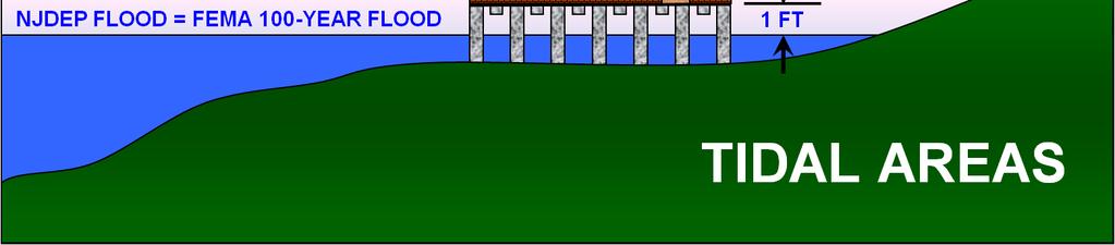
9 Basic Comparison Federal Administered by FEMA and implemented locally State Administered and implemented by NJDEP Community participation in NFIP is voluntary NJDEP requirements are mandatory Uses 100-year flood Uses 100-year flood in tidal areas and larger flood in non-tidal areas* *Explained shortly
10 Basic Comparison (continued) Federal Sets minimum requirements for buildings State Sets minimum requirements for all structures (roads, bridges, utilities, etc.) Lowest floor of buildings must be at or above 100- year flood elevation Lowest floor of buildings must be at least one foot above flood hazard area design flood elevation* *Also explained shortly
11 Basic Comparison (continued) Federal Does not limit flood storage displacement (net-fill) State Limits flood storage displacement (net-fill) in non-tidal areas Focuses on how flooding impacts development Focuses on how flooding impacts development and how development impacts flooding
12 Basic Comparison (continued) Federal Different floor elevation standards for Zone AE and Zone V State Some differentiation between Zone AE and V Generally does not permit wet flood-proofing (except for water-dependent uses and some other limited cases) Permits wet floodproofing for nonresidential buildings that cannot feasibly be elevated or dry floodproofed

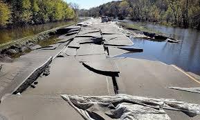
13 Basic Purpose of NJ FHA rules 1. Prevent flooding from getting worse Development can obstruct flood flows and displace flood storage, which makes floodplains deeper and wider, and subjects more people and property to flooding
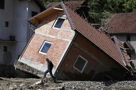
14 Basic Purpose of NJ FHA rules 2. Protect people, property & the environment Sets floor elevation for habitable buildings Sets design standards for all structures in flood hazard area Sets access requirements for roads & buildings Sets limits on riparian zone vegetation removal Ensures that development does not adversely impact T&E species, aquatic biota, etc.

15
16 Brief History of State program 1929: State begins regulating stream encroachments 15-year flood was design standard for most construction work. For drainage basins over 50 square miles, a 50- year flood was used. 1962: Governor Hughes authorizes the State to delineate and mark flood hazard areas
17 Brief History of State program 1970: NJDEP formed Assumes responsibility for stream encroachment program 1972: Governor Cahill signs the Flood Plains Act Authorizes NJDEP to adopt floodway regulations and to promulgate minimum standards for local rules and regulations concerning development in the flood fringe
18 Brief History of State program 1974: NJ Water Policy and Supply Council sets NJ s design flood and floodway limits Equal to 125% of FEMA 100-year flow rate Additional flow determined to be necessary as a factor-of-safety to account for potential future increases in flood elevations due to development Floodway to be computed based on 0.2-ft rise (other States use 1-ft rise) resulted in wider floodways that other States
19 Brief History of State program 1975: NJDEP adopts floodway rules to: Minimize flood damage caused by land uses Minimize degradation of water quality from point and non-point pollution sources Protect wildlife and fisheries by preserving and enhancing the environment of the floodplain. Applied only to development within the floodway
20 Brief History of State program 1977: NJDEP adopts 0% net-fill restrictions in the Central Passaic River Basin Placing fill in the flood fringe displaces floodwaters and therefore causes flooding to increase in depth and extent 1980: Flood Hazard Area Control Act adopted Grants NJDEP broad powers to regulate development in flood hazard areas
21 Brief History of State program 1984: NJDEP adopts 20% net-fill restriction Applies to all other non-tidal flood hazard areas 1995: New stream encroachment rules adopted Increased protection of near-stream vegetation Lowest floor of buildings must be set at or above design flood elevation (NJDFE in non-tidal areas)
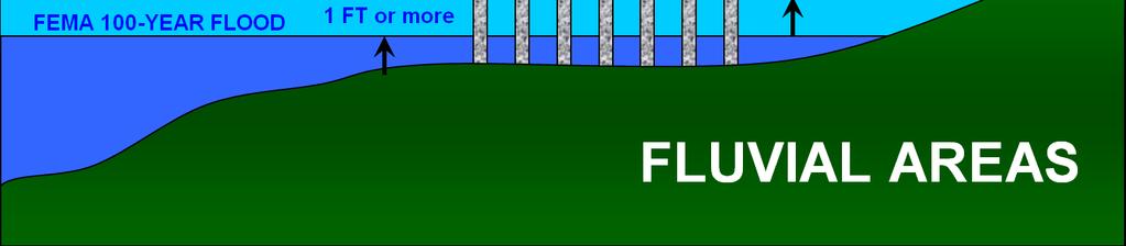
22 Brief History of State program 2007: Stream encroachment rules repealed and new flood hazard area rules adopted 50, 150 & 300-ft riparian zones established 0% net-fill applied to all non-tidal flood hazard areas New process to verify extent of flood hazard areas and riparian zones Six methods to calculate flood hazard area Lowest floor of buildings must be set at least one foot above design flood elevation
23 Brief History of State program 2013: NJDEP adopts emergency amendments to flood hazard area rules Incorporated FEMA advisory and work maps Incorporated new FEMA maps that show flood hazard area design flood elevation Changed how to calculate flood hazard area design flood elevation
24 FloodHazardArea

25 FloodHazardArea In NJ, the flood hazard area is determined by the extent of the Flood Hazard Area Design Flood
26 FloodHazardArea The flood hazard area is comprised of the floodway and flood fringe
27 What is a 100-Year Flood? More accurately described as a 1% flood Within a given year, this flood has a one percent probability of occurring Over time, a flood of this magnitude happens about once every century at a given location
28 NJ Flood Hazard Area Design Flood In tidal areas:equal to FEMA 100-yr flood Use FEMA effective map, or newer advisory/work map, whichever has higher flood elevation
29 NJ Flood Hazard Area Design Flood In fluvial areas: equal to FEMA 100-yr flood plus a factor-of-safety NJDEP flood maps: based on 125% of 100-yr flow Use highest FEMA elevation above + 1 foot or use flood hazard area design flood elevation from NJDEP mapping whichever is higher Or you can calculate flood based on 125% of 100-yr flow

30 Flood Mapping Sources NJDEP flood mapping FEMA flood mapping Self-calculated mapping
31 NJDEP Flood Mapping About 2,500 miles of streams & rivers have State flood mapping Mostly in fluvial (non-tidal) areas Listed in Flood Hazard Area Control Act rules Rule can be downloaded at: Get copies by calling (609)

32 FEMA Flood Insurance Study (FIS) Contains: Information regarding flooding in a community, developed as the basis and in conjunction with the FIRM Flooding sources Flood history Stillwater elevations for various return periods Hydrology and hydraulic information Source: FEMA
33 Finding and Using a FIS The FEMA Map Service Center: (or Google search for FEMA MSC" and "FIS ) FIS tutorial: htm (or Google search for FEMA," "FIS," and "tutorial") Source: FEMA
34 FEMA Flood Insurance Rate Maps FIRMs are used to determine flood insurance rates and premiums FIRMs depict BFEs or flood depths, floodways, and common physical features (e.g., roads) Information shown on FIRMs affects design FEMA FIRM Tutorial link: Source: FEMA
35 AE-Zone vs. V-Zone V-Zone: Wave Height at least 3 feet AE-Zone: Wave Height less than 3 feet Note: Portions of the A-Zone with a wave height of between 1.5 to 3 feet are referred to as the Coastal A-Zone
36 Incorporating FEMA maps NJDEP is working with FEMA to remap the State s flood hazard areas People will easily see NJDEP & FEMA mapping online FEMA is putting NJDEP s design flood elevation on its maps
37 Incorporating FEMA maps If FEMA adopts a map showing NJDEP design flood elevation, it will automatically become a NJDEP map and replace any old flood maps FEMA adopted such mapping along the Delaware River in Hunterdon, Warren & Sussex Counties, so the FHA rule automatically incorporated it, as of 1/24/13
38 State vs. FEMA NJDEP FHA: Surface of lowest floor must be elevated at least one foot above design flood elevation regardless of A zone or V zone. Lowest floor must therefore be: One foot above the BFE in tidal areas; and At least two feet above the BFE in fluvial areas

39 State vs. FEMA FEMA/UCC: In Zone AE: surface of lowest floor must be elevated to at least the BFE. In Zone V: lowest horizontal member must be elevated to at least the BFE(and may be required to be 1 ft. above BFE depending on the angle of the member compared with wave direction)
40 State vs. FEMA Therefore: In Zone AE, NJDEP is more stringent than Uniform Construction Code In Zone V, Uniform Construction Code may be more stringent than NJDEP (depending on the thickness of the floor and direction of waves)

41 NJDEP Floor Elevations The FHA rules set standards for the lowest floor of habitable buildings Non-habitable buildings do not need to be elevated Note: NJDEP sets floor elevation but UCC sets specific building standards
42 Habitable Buildings The lowest floor of residential buildings must be elevated one foot above the design flood elevation Lowest floor means the top of the floor the walking surface* An unfinished enclosure, such as a crawl space, entryway and/or garage is not considered the lowest floor *Note: FEMA/UCC measure this differently in Zone V

43 NJDEP Lowest Floor

44 NJDEP Lowest Floor
45 Habitable Buildings The lowest floor of non-residential buildings must be: Elevated one foot above the design flood elevation; or If elevating is not feasible, it must be dry flood-proofed; or If dry flood-proofing is not feasible, it must be wet flood-proofed
46 For More Information: Peter DeMeo, PE Supervising Environmental Engineer NJDEP Division of Land Use Regulation Trenton, NJ Phone: (609) Website:
BASICS OF FLOODPLAIN MANAGEMENT & PLANNING IN NEW JERSEY
 BASICS OF FLOODPLAIN MANAGEMENT & PLANNING IN NEW JERSEY STATE OF NEW JERSEY DEPARTMENT OF ENVIRONMENTAL PROTECTION VINCENT J. MAZZEI, JR., PE November 12, 2008 Flood Hazard Areas What is a 100-year flood?
Flood Hazard Area Control Act Rules
 An Overview of New Jersey s Flood Hazard Area Control Act Rules State of New Jersey Department of Environmental Protection Chingwah Liang Why Regulate NJ s Floodplains? 1. New Jersey endures enormous
Floodplain Development Land Use Review
 PUBLIC WORKS - COMMUNITY DEVELOPMENT 333 Broadalbin Street SW, PO Box 490, Albany, Oregon 97321-0144 BUILDING 541-917-7553 PLANNING 541-917-7550 Floodplain Development Land Use Review Application Information
ORDINANCE NO (1123)
") ORDINANCE NO. 2013-08 (1123) ORDINANCE OF THE BOROUGH OF LAVALLLETTE, COUNTY OF OCEAN, STATE OF NEW JERSEY, AMENDING AND SUPPLEMENTING CHAPTER 31, ENTITLED FLOOD HAZARD AREAS, OF THE REVISED GENERAL ORDINANCES
ORDINANCE NO. 2013-08 (1123) ORDINANCE OF THE BOROUGH OF LAVALLLETTE, COUNTY OF OCEAN, STATE OF NEW JERSEY, AMENDING AND SUPPLEMENTING CHAPTER 31, ENTITLED FLOOD HAZARD AREAS, OF THE REVISED GENERAL ORDINANCES
Flood Hazard Zone. [Amended effective ; ; ; ; ; ]
![Flood Hazard Zone. [Amended effective ; ; ; ; ; ]](/thumbs/82/86423647.jpg "Flood Hazard Zone. [Amended effective ; ; ; ; ; ]") ARTICLE 110, Flood Hazard Zone [Added effective 4-24-1978] 118-1100. Flood Hazard Zone. [Amended effective 8-19-1986; 2-26-1993; 6-18-2010; 12-24- 2010; 7-8-2013; 7-25-2014] A. Purpose and intent. (1)
ARTICLE 110, Flood Hazard Zone [Added effective 4-24-1978] 118-1100. Flood Hazard Zone. [Amended effective 8-19-1986; 2-26-1993; 6-18-2010; 12-24- 2010; 7-8-2013; 7-25-2014] A. Purpose and intent. (1)
Date of Review: 11/6/2015 Reviewer: RCQ/LMC STATE
 FINAL Florida Review Checklist: NFIP & FBC & Revised Model Ordinance (January 15, 2013d) Ordinance Citation: Model FPM regulations and 5 th Edition FBC : All Zones Date of Review: 11/6/2015 Reviewer: RCQ/LMC
Flood Hazard Development Permit Application & Permit Forms. For Communities with Coastal Velocity Zones [60.3(e)] CONTENTS
![Flood Hazard Development Permit Application & Permit Forms. For Communities with Coastal Velocity Zones [60.3(e)] CONTENTS](/thumbs/76/74346075.jpg "Flood Hazard Development Permit Application & Permit Forms. For Communities with Coastal Velocity Zones [60.3(e)] CONTENTS") Flood Hazard Development Permit Application & Permit Forms For Communities with Coastal Velocity Zones [60.3(e)] CONTENTS 1. Decision Tree 2. Flood Hazard Development Permit Application 3. Flood Hazard
Flood Hazard Development Permit Application & Permit Forms For Communities with Coastal Velocity Zones [60.3(e)] CONTENTS 1. Decision Tree 2. Flood Hazard Development Permit Application 3. Flood Hazard
(Chapter Flood Damage Prevention)
") Chapter 13.10 Flood Damage Prevention Section: 13.10.010 Purpose and Policy 13.10.020 Definitions 13.10.030 Applicability and Areas of Special Flood Hazard 13.10.040 Administration 13.10.050 Provisions
Chapter 13.10 Flood Damage Prevention Section: 13.10.010 Purpose and Policy 13.10.020 Definitions 13.10.030 Applicability and Areas of Special Flood Hazard 13.10.040 Administration 13.10.050 Provisions
DIVISION 1. - GENERAL PROVISIONS
 Sec. 90-708. - Statutory authorization and purpose. Sec. 90-709. - Applicability. Sec. 90-710. - Compliance and liability. Sec. 90-711. - Records. Sec. 90-712. - Abrogation and greater restrictions. Sec.
Letter of Map Change Fundamentals
 Letter of Map Change Fundamentals FEMA Region III National Flood Insurance Program Essentials and Best Practices Jana Green, CFM, RAMPP Topics of Discussion Why Apply for a Letter of Map Change (LOMC)?
THIS ARTICLE HAS BEEN COMPLETELY REWRITTEN. Chapter CRITICAL AREAS. Article XIX. Flood Hazard Areas. Article XIX. Flood Hazard Areas
 THIS ARTICLE HAS BEEN COMPLETELY REWRITTEN Chapter 18.55 CRITICAL AREAS Sections: Article XIX. Flood Hazard Areas 18.55.700 Purpose. 18.55.705 Definitions 18.55.707 Lands to which this article applies.
RD:VMT:NGA ORD. NO /3/09 ORDINANCE NO
 ORDINANCE NO. 28512 AN ORDINANCE OF THE CITY OF SAN JOSE AMENDING CHAPTER 17.08 OF TITLE 17 OF THE SAN JOSE MUNICIPAL CODE TO UPDATE THE CITY S SPECIAL FLOOD HAZARD REGULATIONS WHEREAS, the Council of
ORDINANCE NO TOWNSHIP OF EAST WINDSOR COUNTY OF MERCER
 ORDINANCE NO. 2016-07 TOWNSHIP OF EAST WINDSOR COUNTY OF MERCER AN ORDINANCE REPEALING SECTION 22-4: FLOOD DAMAGE PREVENTION CODE, OF THE REVISED GENERAL ORDINANCES OF THE TOWNSHIP OF EAST WINDSOR AND
Chapter 5. Floodplain Management. 5.0 Introduction. 5.1 Floodplain Management and Regulation
 5.0 Introduction This chapter summarizes the Town s rules and regulations regarding floodplain management and development. The requirements presented in this chapter should be used by the design engineer
Oxford Floodplain Management Ordinance
 Table of Contents SECTION 1.0 GENERAL PROVISIONS...1 1.1 Findings...1 1.2 Statutory Authorization...1 1.3 Statement of Purpose...1 1.4 Areas to Which These Regulations Apply...2 1.5 Basis for Establishing
Chapter 5. Floodplain Management. 5.0 Introduction. 5.1 Douglas County Comprehensive Master Plan. 5.2 Floodplain Management and Regulation
 5.0 Introduction This chapter summarizes the County s rules and regulations regarding floodplain management and development. The requirements presented in this chapter should be used by the design engineer
2016 Fredericksburg Area Floodplain Management Workshop Tuesday, October 25, 2016
 2016 Fredericksburg Area Floodplain Management Workshop Tuesday, October 25, 2016 Charley Banks, CFM Department of Conservation And Recreation Division of Dam Safety & Floodplain Management Some Soapbox
Title 15. Buildings, Construction, Addressing and Land Use
 Chapters: 15.05 Land Use Fees 15.10 Flood Damage Prevention 15.15 Building Numbering Title 15 Buildings, Construction, Addressing and Land Use 15-1 Lyons Municipal Code 15.05.040 Chapter 15.05 Land Use
CITY OF CAMBRIDGE FLOODPLAIN MANAGEMENT CHAPTER 7 (GRADING, EROSION AND SEDIMENT CONTROL)
") CITY OF CAMBRIDGE FLOODPLAIN MANAGEMENT CHAPTER 7 (GRADING, EROSION AND SEDIMENT CONTROL) City of Cambridge, MD Floodplain Management Ordinance (Tidal): May, 2011 1 City of Cambridge, Maryland Floodplain
CITY OF CAMBRIDGE FLOODPLAIN MANAGEMENT CHAPTER 7 (GRADING, EROSION AND SEDIMENT CONTROL) City of Cambridge, MD Floodplain Management Ordinance (Tidal): May, 2011 1 City of Cambridge, Maryland Floodplain
COMMERCIAL SITE DEVELOPMENT GUIDE FOR UNINCORPORATED ST. CHARLES COUNTY
 COMMERCIAL SITE DEVELOPMENT GUIDE FOR UNINCORPORATED ST. CHARLES COUNTY GENERAL INFORMATION: This brochure is to be used as a guide and is not intended to amend or supersede the corresponding County ordinances
National Flood Insurance Program
 National Flood Insurance Program Base Flood Elevations in Zone A Streams Surveyor Training Presented by Thomas F. Smith, PE, PLS January 22, 2018 1 FEMA Region III Mitigation Division Floodplain Management
MANSFIELD TOWNSHIP BURLINGTON COUNTY ORDINANCE
 MANSFIELD TOWNSHIP BURLINGTON COUNTY ORDINANCE 2017-15 AN ORDINANCE TO AMEND THE CODE OF THE TOWNSHIP OF MANSFIELD BY DELETING AND REPEALING CHAPTER 22 THEREOF, ENTITLED FLOOD DAMAGE PREVENTION, AND REPLACING
Regulatory Fee Schedule
 Regulatory Schedule STATE OF NEW JERSEY DEPARTMENT OF ENVIRONMENTAL PROTECTION DIVISION OF LAND USE REGULATION Website: www.state.nj.gov/dep/landuse Revised September 2017 All permit fees shall be paid
FLOOD DAMAGE REDUCTION RESOLUTION GREENE COUNTY, OHIO
 FLOOD DAMAGE REDUCTION RESOLUTION GREENE COUNTY, OHIO SECTION 101.01: GENERAL PROVISIONS 101.01.1 Statutory Authorization This resolution is adopted pursuant to authorization contained in Sections 307.37
On motion by, and seconded by, All Council Members present, the following ordinance was introduced: ORDINANCE 1552
 On motion by, and seconded by, All Council Members present, the following ordinance was introduced: ORDINANCE 1552 An ordinance repealing Chapter 10 BUILDING AND CONSTRUCTION REGULATIONS - Article II Special
KING WILLIAM COUNTY PLANNING COMMISSION AGENDA November 18, 2014 Regular Meeting 7:00PM
 KING WILLIAM COUNTY PLANNING COMMISSION AGENDA November 18, 2014 Regular Meeting 7:00PM 1. Call to Order 2. Roll Call 3. General Public Comment Period 4. Public Hearing ORD 14-02 Floodplain Management
FLOOD DAMAGE PREVENTION
 ARTICLE 30 FLOOD DAMAGE PREVENTION 30.01 General Provisions... 30-1 30.02 Administration... 30-2 30.03 Provisions for Flood Hazard Reduction... 30-7 30.01 General Provisions 30.01.01 Lands to Which This
TOWNSHIP OF BASS RIVER Ordinance 2017-
 TOWNSHIP OF BASS RIVER Ordinance 2017- AN ORDINANCE OF THE TOWNSHIP OF BASS RIVER AMENDING CHAPTER 15.24 FLOOD HAZARD AREAS OF THE REVISED ORDINANCES OF BASS RIVER TOWNSHIP WHEREAS, the Bass River Township
SPECIAL PURPOSE FLOOD DAMAGE PREVENTION REGULATIONS for FAIRFIELD COUNTY
 SPECIAL PURPOSE FLOOD DAMAGE PREVENTION REGULATIONS for FAIRFIELD COUNTY Adopted September 7, 1995 Effective October 9, 1995 Flood Maps are available in the Fairfield County Regional Planning Commission
CHAPTER XVII. REGULATION OF FLOOD PLAIN STATUTORY AUTHORIZATION, FINDINGS OF FACT, PURPOSE AND OBJECTIVES
 CHAPTER XVII. REGULATION OF FLOOD PLAIN ARTICLE 1.0 STATUTORY AUTHORIZATION, FINDINGS OF FACT, PURPOSE AND OBJECTIVES 17.0101 STATUTORY AUTHORIZATION The Legislature of the State of North Dakota has in
SPECIAL PURPOSE FLOOD DAMAGE PREVENTION ORDINANCE. Adopted: June 24th, 1998
 SPECIAL PURPOSE FLOOD DAMAGE PREVENTION ORDINANCE Adopted: June 24th, 1998 SECTION 1.0 STATUTORY AUTHORIZATION, FINDINGS OF FACT PURPOSE AND OBJECTIVES 1.1 STATUTORY AUTHORIZATION ARTICLE XVIII, Section
LUZERNE COUNTY ZONING ORDINANCE TEXT AMENDMENTS FLOOD PLAIN MANAGEMENT
 LUZERNE COUNTY ZONING ORDINANCE TEXT AMENDMENTS FLOOD PLAIN MANAGEMENT Eliminate in Article 11 DEFINITIONS The definitions of Flood, Flood- Fringe, Floodway, One Hundred Year Flood and One Hundred (100)
NOTICE
 www.ketteringoh.org NOTICE This City of Kettering Code section is not the official version and is provided only for the convenience of the public. The only official version of the City of Kettering Code
ORDINANCE NO. 14 C2-) AN ORDINANCE OF THE COUNTY OF VENTURA REPEALING AND REENACTING THE VENTURA COUNTY FLOODPLAIN MANAGEMENT ORDINANCE SECTION 1
 AN ORDINANCE OF THE COUNTY OF VENTURA REPEALING AND REENACTING THE VENTURA COUNTY FLOODPLAIN MANAGEMENT ORDINANCE SECTION 1") ORDINANCE NO. 14 C2-) AN ORDINANCE OF THE COUNTY OF VENTURA REPEALING AND REENACTING THE VENTURA COUNTY FLOODPLAIN MANAGEMENT ORDINANCE The Board of Supervisors of the County of Ventura ordains as follows:
ORDINANCE NO. 14 C2-) AN ORDINANCE OF THE COUNTY OF VENTURA REPEALING AND REENACTING THE VENTURA COUNTY FLOODPLAIN MANAGEMENT ORDINANCE The Board of Supervisors of the County of Ventura ordains as follows:
ORDINANCE NO. 992 CITY OF OCEAN SHORES, WASHINGTON
 CITY OF OCEAN SHORES, WASHINGTON ORDINANCE NO. 992 AN EMERGENCY ORDINANCE OF THE CITY COUNCIL OF THE CITY OF OCEAN SHORES, WASHINGTON, AMENDING ORDINANCE NO. 990 AND OCEAN SHORES MUNICIPAL CODE CHAPTER
FLOOD HAZARD (FH) ZONING DISTRICT OR FLOOD HAZARD OVERLAY ZONE (Ord A, 10/20/2009) 1.0 INTRODUCTION
 ZONING DISTRICT OR FLOOD HAZARD OVERLAY ZONE (Ord A, 10/20/2009) 1.0 INTRODUCTION") Page 1 of 27 SECTION 29.4 FLOOD HAZARD (FH) ZONING DISTRICT OR FLOOD HAZARD OVERLAY ZONE (Ord. 315-776A, 10/20/2009) 1.0 INTRODUCTION 1.1 STATUTORY AUTHORIZATION: The Legislature of the State of California
Page 1 of 27 SECTION 29.4 FLOOD HAZARD (FH) ZONING DISTRICT OR FLOOD HAZARD OVERLAY ZONE (Ord. 315-776A, 10/20/2009) 1.0 INTRODUCTION 1.1 STATUTORY AUTHORIZATION: The Legislature of the State of California
Restrict or prohibit uses which are dangerous to health, safety and property due to water or erosion or in flood heights or velocities;
 CODE OF ORDINANCES, CITY OF BRISTOL, CONNECTICUT APPENDIX D, FLOOD DAMAGE PREVENTION (adopted on August 12, 2008) SECTION 1 - STATUTORY AUTHORIZATION, FINDING OF FACT, PURPOSE AND OBJECTIVES 1.1. Statutory
A Flood Mitigation Plan for the Non-Tidal, N.J. Section of the Delaware River Basin
 A Flood Mitigation Plan for the Non-Tidal, N.J. Section of the Delaware River Basin Laura Tessieri, P.E., CFM Delaware River Basin Commission July 16, 2008 Commission Meeting Overall Goal of Plan: To make
The Board of Supervisors of the County of Riverside ordains as follows:
 ORDINANCE NO. 458 (AS AMENDED THROUGH 458.13) AN ORDINANCE OF THE COUNTY OF RIVERSIDE AMENDING ORDINANCE NO. 458 REGULATING FLOOD HAZARD AREAS AND IMPLEMENTING THE NATIONAL FLOOD INSURANCE PROGRAM The
WAYNE COUNTY, WV FLOODPLAIN ORDINANCE
 WAYNE COUNTY, WV FLOODPLAIN ORDINANCE AUTHORITY AND PURPOSE: AN ORDINANCE ESTABLISHING A FLOODPLAIN AREA AND REQUIRING ALL CONTRACTORS, PERSONS, PARTNERSHIPS, BUSINESSES, AND CORPORATIONS TO OBTAIN A PERMIT
MASON COUNTY FLOODPLAIN ORDINANCE
 MASON COUNTY FLOODPLAIN ORDINANCE September 2013 AUTHORITY AND PURPOSE: AN ORDINANCE ESTABLISHING A FLOODPLAIN AREA AND REQUIRING ALL CONTRACTORS, PERSONS, PARTNERSHIPS, BUSINESSES, AND CORPORATIONS TO
Town of Alexandria. Floodplain Management Ordinance
 1 of 7 8/8/2009 4:56 PM Town of Alexandria Floodplain Management Ordinance SECTION 1 PURPOSE Certain areas of the Town of Alexandria, New Hampshire are subject to periodic flooding, causing serious damages
Florida CRS Initiative CRS CAV Pilot Program
 Florida CRS Initiative CRS CAV Pilot Program Enrolling Communities in the Community Rating System SEVEN PERFORMANCE MEASURES 2015-2017 Bureau of Mitigation Florida Division of Emergency Management STATE
ORDINANCE NO. 990 CITY OF OCEAN SHORES, WASHINGTON. NOW, THEREFORE, the City Council of the Ocean Shores does hereby ordain as follows:
 CITY OF OCEAN SHORES, WASHINGTON ORDINANCE NO. 990 AN ORDINANCE OF THE CITY COUNCIL OF THE CITY OF OCEAN SHORES, WASHINGTON, AMENDING OCEAN SHORES MUNICIPAL CODE CHAPTER 15.36 FLOOD DAMAGE PREVENTION WHEREAS,
MODEL FLOODPLAIN MANAGEMENT / FLOOD DAMAGE PREVENTION ORDINANCE
 MODEL FLOODPLAIN MANAGEMENT / FLOOD DAMAGE PREVENTION ORDINANCE Description: Floodplain management involves the designation of flood-prone areas and the managing of their uses. It is also aimed at minimizing
CARTER COUNTY, OKLAHOMA FLOODPLAIN BOARD REGULATIONS ARTICLE I STATUTORY AUTHORIZATION, FINDINGS OF FACT, PURPOSE AND METHODS
 CARTER COUNTY, OKLAHOMA FLOODPLAIN BOARD REGULATIONS ARTICLE I STATUTORY AUTHORIZATION, FINDINGS OF FACT, PURPOSE AND METHODS SECTION A. STATUTORY AUTHORIZATION The Legislature of the State of Oklahoma
TUSCARAWAS COUNTY FLOOD DAMAGE REDUCTION REGULATIONS
 TUSCARAWAS COUNTY FLOOD DAMAGE REDUCTION REGULATIONS 2010 Approved for adoption by ODNR 5/11/07 Adopted by the Board of Tuscarawas County Commissioners Date: October 1, 2007 Resolution No: 736-2007 Revised
Floodway and Flood Plain Districts
 Chapter 6 Floodway and Flood Plain Districts 6.010 - Purpose To establish land use regulations for properties situated in floodways and flood plain lands so as to: A. Minimize property damage from flood
Cibola County Floodplain Development Permit Application
 Cibola County Floodplain Development Permit Application Application # FP Use Permit Variance Appeal Permit Fee $25.00 Date SECTION I: GENERAL PROVISIONS (APPLICANT to read and sign) 1. No work of any kind
CHAPTER 5 FLOOD DAMAGE PREVENTION. Statutory Authorization, Findings of Fact, Purpose, Methods, and Definitions
 CHAPTER 5 FLOOD DAMAGE PREVENTION Article A. Section 5.1 Section 5.2 Section 5.3 Section 5.4 Section 5.5 Article B. Statutory Authorization, Findings of Fact, Purpose, Methods, and Definitions Statutory
Facts on Metro Nashville s Development of a Hazard Mitigation Home Buyout Program in Response to the May 2010 Flood June 3, 2010
 Facts on Metro Nashville s Development of a Hazard Mitigation Home Buyout Program in Response to the May 2010 Flood June 3, 2010 Summary: The Metropolitan Government of Nashville is currently working to
MT 1, MT 2, Elevation Certificates & the Role of Surveyors
 MT 1, MT 2, Elevation Certificates & the Role of Surveyors Rocky Mountain Surveyors Summit March 3, 2016 Floods are acts of God, but flood losses are largely acts of man. - Dr. Gilbert White the father
ARTICLE 18 TABLE OF CONTENTS TO THE FLOODPLAIN MANAGEMENT REGULATIONS
 Table of Contents Valley Center Floodplain Ordinance ARTICLE 18 TABLE OF CONTENTS TO THE FLOODPLAIN MANAGEMENT REGULATIONS Chapter 18.01 STATUTORY AUTHORIZATION, FINDINGS OF FACT & PURPOSES...1 18.01.01
CHAPTER 1108 Flood Damage Protection
 CHAPTER 1108 Flood Damage Protection 1108.01 General Provisions. 1108.02 Definitions. 1108.03 Administration. 1108.04 Use and development standards for flood hazard reduction. 1108.05 Appeals and variances.
FLOODPLAIN MANAGEMENT ORDINANCE
 Higher Regulatory Standards FLOODPLAIN MANAGEMENT ORDINANCE For Jefferson County, Alabama Unincorporated Areas Adopted by the Jefferson County Commission On September 19, 2006 Title TABLE OF CONTENTS Page
BOARD OF COUNTY COMMISSIONERS
 BOARD OF COUNTY COMMISSIONERS ORDINANCE NO. AN ORDINANCE AMENDING THE PASCO COUNTY LAND DEVELOPMENT CODE SECTION 1104 FLOOD DAMAGE PREVENTION; APPENDIX A DEFINITIONS; AND OTHER SECTIONS, AS NECESSARY,
FEMA POLICY: GUIDANCE ON THE USE OF AVAILABLE FLOOD HAZARD INFORMATION
 FEMA POLICY: GUIDANCE ON THE USE OF AVAILABLE FLOOD HAZARD INFORMATION FEMA Policy #104-008-2 BACKGROUND The policy is for FEMA Headquarters, Regional program staff, and for the Field Staff at the Joint
YOLO COUNTY ZONING CODE TITLE 8 LAND DEVELOPMENT CHAPTER 4: FLOOD PROTECTION. Article 1: Findings of Fact, Purpose and Methods
 YOLO COUNTY ZONING CODE TITLE 8 LAND DEVELOPMENT CHAPTER 4: FLOOD PROTECTION Article 1: Findings of Fact, Purpose and Methods Sec. 8-4.101 Statutory authorization The Legislature of the State of California
CHAPTER 24. Environmental Regulations ARTICLE I
 CHAPTER 24 Environmental Regulations ARTICLE I Flood Damage Prevention Ordinance (FDPO) The FDPO adopted in 2008 was rescinded in its entirety on June 13, 2014, and a new version was adopted to make changes
TOWN OF WILMINGTON FLOOD AND FLUVIAL EROSION HAZARD REGULATIONS
 Draft Wilmington Flood Hazard Regulation February 2019 TOWN OF WILMINGTON FLOOD AND FLUVIAL EROSION HAZARD REGULATIONS Contents 600. Statutory Authorization and Effect... 1 601. Statement of Purpose...
[Docket ID FEMA ; Internal Agency Docket No. FEMA-B AGENCY: Federal Emergency Management Agency, DHS.
 This document is scheduled to be published in the Federal Register on 09/25/2017 and available online at https://federalregister.gov/d/2017-20468, and on FDsys.gov 1 Billing Code 9110-12-P DEPARTMENT OF
LINCOLN COUNTY FLOOD DAMAGE PREVENTION ORDINANCE
 LINCOLN COUNTY FLOOD DAMAGE PREVENTION ORDINANCE SECTION 1.0 STATUTORY AUTHORIZATION, FINDINGS OF FACT, PURPOSE AND OBJECTIVES SECTION 2 DEFINITIONS SECTION 3.0 GENERAL PROVISIONS SECTION 4.0 ADMINISTRATION
City of Ferndale Floodplain Management Ordinance Page 1 of 18 ORDINANCE 08-02
 City of Ferndale Floodplain Management Ordinance 08-02 Page 1 of 18 ORDINANCE 08-02 AN ORDINANCE OF THE CITY COUNCIL OF THE CITY OF FERNDALE ESTABLISHING THE MINIMUM REQUIREMENTS OF THE NATIONAL FLOOD
TITLE 14 ZONING AND LAND USE CONTROL CHAPTER 1 MUNICIPAL PLANNING COMMISSION
 Change 2, December 8, 2014 14-1 TITLE 14 ZONING AND LAND USE CONTROL CHAPTER 1. MUNICIPAL PLANNING COMMISSION. 2. FLOOD DAMAGE PREVENTION ORDINANCE. 3. SIGN ORDINANCE. CHAPTER 1 MUNICIPAL PLANNING COMMISSION
An Ordinance of the City of Shady Cove, Oregon An Oregon Municipal Corporation
 An Ordinance of the City of Shady Cove, Oregon An Oregon Municipal Corporation ORDINANCE NO. 259 Establishing Regulations To Prevent Flood Damage Within The City Of Shady Cove, Oregon, Adopting Related
CITY OF AUSTELL DESIGN AND CONSTRUCTION STANDARDS LAND DEVELOPMENT ORDINANCES
 CITY OF AUSTELL DESIGN AND CONSTRUCTION STANDARDS LAND DEVELOPMENT ORDINANCES Land Development Ordinances Section 8 CITY OF AUSTELL DESIGN AND CONSTRUCTION STANDARDS LAND DEVELOPMENT ORDINANCES Article
(Ord. No. 743, )
") CHAPTER 330. - FLOODPLAIN MANAGEMENT Section 330-1. - Purpose. (a) (b) (c) (d) It is hereby determined that the flood hazard areas of the City of Chamblee are subject to periodic inundation which may result
CHAPTER 330. - FLOODPLAIN MANAGEMENT Section 330-1. - Purpose. (a) (b) (c) (d) It is hereby determined that the flood hazard areas of the City of Chamblee are subject to periodic inundation which may result
The Uniform Act. Acquisition, Relocation & Demolition. Disaster Recovery CDBG Administration Training. February 14, 2012
 The Uniform Act Acquisition, Relocation & Demolition Disaster Recovery CDBG Administration Training February 14, 2012 Uniform Act Overview 49 CFR 24 Protections and assistance to establish minimum standards
ARTICLE 16. FLOODPLAIN MANAGEMENT, EROSION AND SEDIMENT CONTROL, AND STORMWATER MANAGEMENT
 ARTICLE 16. FLOODPLAIN MANAGEMENT, EROSION AND SEDIMENT CONTROL, AND STORMWATER MANAGEMENT Title 1. DEFINITIONS AND GENERAL PROVISIONS 2. FLOODPLAIN MANAGEMENT 3. EROSION AND SEDIMENT CONTROL 4. STORMWATER
ORDINANCE NO
 ORDINANCE NO. 11-311 AN ORDINANCE OF THE CITY OF MONTROSE, SD, AMENDING THE REVISED MUNICIPAL ORDINANCES OF THE CITY BY AMENDING CHAPTER 9.04, FLOOD INSURANCE. BE IT ORDAINED BY THE CITY OF MONTROSE, SD:
TITLE 14 ZONING AND LAND USE CONTROL CHAPTER 1 MUNICIPAL PLANNING COMMISSION
 14-1 TITLE 14 ZONING AND LAND USE CONTROL CHAPTER 1. MUNICIPAL PLANNING COMMISSION. 2. ZONING ORDINANCE. 3. FLOOD DAMAGE PREVENTION ORDINANCE. CHAPTER 1 MUNICIPAL PLANNING COMMISSION SECTION 14-101. Creation
Section Floodplain Development Ordinance This ordinance, adopted pursuant to the authority of RSA 674:16, shall be known as the Town of Newport
 Section 212 - Floodplain Development Ordinance This ordinance, adopted pursuant to the authority of RSA 674:16, shall be known as the Town of Newport Floodplain Development Ordinance. The regulations and
Permit Application No. Development Address. Legal Description. A. Flood Plain and Floodway Information and Sources: (To be completed by Surveyor)
") FLOOD PLAIN DEVELOPMENT PERMIT APPLICATION Leavenworth County Planning and Zoning Department 300 Walnut St. County Courthouse Leavenworth, Kansas 66048 (913) 684-0465 FAX (913) 684-0398 Permit Application
FLOOD PLAIN DEVELOPMENT PERMIT APPLICATION Leavenworth County Planning and Zoning Department 300 Walnut St. County Courthouse Leavenworth, Kansas 66048 (913) 684-0465 FAX (913) 684-0398 Permit Application
City of Gilroy STAFF REPORT
 10.C City of Gilroy STAFF REPORT Agenda Item Title: Consideration of an Ordinance of the City Council of the City of Gilroy Repealing Ordinance No. 98-17 Entitled "Floodplain Management Ordinance" In It's
Waupaca County. Floodplain. Ordinance
 Waupaca County Floodplain Ordinance Ordinance No. 18 Floodplain Ordinance was adopted by the Waupaca County Board on July 28, 1977. Amend Ordinance #87-16-01 to repeal and re-enact the Waupaca County Floodplain
Chapter 8.01 FLOOD DAMAGE PREVENTION
 8.01.010 Chapter 8.01 FLOOD DAMAGE PREVENTION Sections: 8.01.010 Statutory authorization. 8.01.011 Findings of fact. 8.01.012 Statement of purpose. 8.01.013 Methods of reducing flood losses. 8.01.020 Definitions.
ORDINANCE NO
 ORDINANCE NO. 14 126 Introduced by: Joseph M. Reda Date of introduction: TO AMEND CHAPTER 40 OF THE NEW CASTLE COUNTY CODE (ALSO KNOWN AS THE UNIFIED DEVELOPMENT CODE OR UDC ), ARTICLE 4 ( DISTRICT INTENSITY
Criteria for Appeals of Flood Insurance Rate Maps. November 30, 201 1
 Criteria for Appeals of Flood Insurance Rate Maps November 30, 201 1 This document outlines the criteria for appealing proposed changes in flood hazard information on Flood Insurance Rate Maps (FIRMS)
NOTICE OF LAND USE DECISION BY THE COOS COUNTY PLANNING DIRECTOR
 NOTICE OF LAND USE DECISION BY THE COOS COUNTY PLANNING DIRECTOR Coos County Planning 225 N. Adams St. Coquille, OR 97423 http://www.co.coos.or.us/ Phone: 541-396-7770 Fax: 541-396-1022 This notice is
ORDINANCE #8.3 FLOODPLAIN ZONING ORDINANCE FOR DOUGLAS COUNTY, WISCONSIN
 ORDINANCE #8.3 FLOODPLAIN ZONING ORDINANCE FOR DOUGLAS COUNTY, WISCONSIN THE COUNTY BOARD OF SUPERVISORS OF THE COUNTY OF DOUGLAS DOES ORDAIN AS FOLLOWS: SECTION I. STATUTORY AUTHORIZATION, FINDING OF
Amendments to Chapter proposed by the Assembly Title 21 Committee
 Amendments to Chapter 21.04 proposed by the Assembly Title 21 Committee All page numbers refer to the S version. PZC recommended additions are underlined. PZC recommended deletions are in [BRACKETS AND
FLOOD DAMAGE PREVENTION COURT ORDER ARTICLE I STATUTORY AUTHORIZATION, FINDINGS OF FACT, PURPOSE AND METHODS
 FLOOD DAMAGE PREVENTION COURT ORDER ARTICLE I STATUTORY AUTHORIZATION, FINDINGS OF FACT, PURPOSE AND METHODS SECTION A. STATUTORY AUTHORIZATION The Legislature of the State of Texas has in the Flood Control
For public hearing by the Town Council and Planning Commission March 24, 2014
 AN ORDINANCE TO AMEND SECTION 17.0 FLOOD HAZARD OVERLAY DISTRICT FH OF THE ZONING ORDINANCE OF THE TOWN OF SCOTTSVILLE, VIRGINIA BE IT ORDAINED by the Town Council of the Town of Scottsville, Virginia,
SPECIAL PURPOSE FLOOD DAMAGE REDUCTION RESOLUTION FOR PICKAWAY COUNTY, OHIO
 SPECIAL PURPOSE FLOOD DAMAGE REDUCTION RESOLUTION FOR PICKAWAY COUNTY, OHIO Effective December 7, 2012 Pickaway County Board of Commissioners Glenn D. Reeser Jay H. Wippel Ula Jean Metzler Terry L. Frazier,
ORDINANCE # ARTICLE I STATUTORY AUTHORIZATION, FINDINGS OF FACT, PURPOSE AND METHODS
 60.3 (b) FLOOD DAMAGE PREVENTION ORDINANCE ORDINANCE #2009-07 ARTICLE I STATUTORY AUTHORIZATION, FINDINGS OF FACT, PURPOSE AND METHODS SECTION A. STATUTORY AUTHORIZATION The Legislature of the State of
CHAPTER 1313 Flood Damage Prevention Statutory authorization Exemption from filing a Findings
 11 CHAPTER 1313 Flood Damage Prevention 1313.01 Statutory authorization. 1313.02 Findings of fact. 1313.03 Statement of purpose. 1313.04 Methods of reducing flood losses. 1313.05 Lands to which these regulations
***** Subchapter A. GENERAL PROVISIONS ***** PERMIT APPLICATIONS
 105.11. Permit requirements. 105.12. Waiver of permit requirements. Title 25 Environmental Protection Part I. Department of Environmental Protection Subpart C. Protection of Natural Resources Article I.
ORDINANCE NO. THE CITY COUNCIL OF THE CITY OF BISHOP, STATE OF CALIFORNIA DOES ORDAIN AS FOLLOWS:
 ORDINANCE NO. AN ORDINANCE OF THE CITY COUNCIL OF THE CITY OF BISHOP, STATE OF CALIFORNIA, REPEALING BISHOP MUNICIPAL CODE CHAPTER 15.20 ENTITLED FLOOD DAMAGE PREVENTION AND ORDINANCE NOS. 432 AND 450,
ORDINANCE NO
 ORDINANCE NO. 2001-2 AN ORDINANCE OF THE TOWN COUNCIL OF THE TOWN OF SOUTHWEST RANCHES, FLORIDA, CREATING A PLAN FOR FLOOD DAMAGE PREVENTION TO MINIMIZE PUBLIC AND PRIVATE LOSSES DUE TO FLOOD CONDITIONS
Final Plats for Major Residential and Commercial Subdivisions Checklist
 Project Name: : This form is a checklist of Zoning Ordinance requirements for major residential and commercial subdivision plats to assist the applicant in their submittal. It is not intended to be a comprehensive
Notice of Intent Supplemental Form for Riverfront Area
 Notice of Intent Supplemental Form for Riverfront Area The Notice of Intent Supplemental Form for Riverfront Area is recommended for use with the Notice of Intent (Form 3) in the wetland regulations (310
CHAPTER 16. ZONING AND PLANNING
 CHAPTER 16. ZONING AND PLANNING Article 1. Zoning Regulations Article 2. Floodplain Management Article 3. Subdivision Regulations Article 4. Comprehensive Land Use Plan ARTICLE 1. ZONING REGULATIONS 16-101.
CHAPTER 24 F FLOOD ZONE OVERLAY DISTRICT
 CHAPTER 24 OVERLAY DISTRICT SECTION 24.01 PURPOSE It is the intent of this district to apply special regulation to the use of land in those areas subject to periodic inundation. Such regulation is deemed
CHAPTER 109 NATURAL RESOURCES AND ENVIRONMENTAL PROTECTION. ARTICLE I. Flood Damage Prevention In General
 Sec. 109-1. - Authorization. CHAPTER 109 NATURAL RESOURCES AND ENVIRONMENTAL PROTECTION ARTICLE I. Flood Damage Prevention In General Article IX, Section II of the Constitution of the State of Georgia
MAP INDEX CHECKLIST NOTES:
 REVIEWING YOUR PRELIMINARY DFIRM PANELS AND FIS REPORT A GUIDE FOR COMMUNITY OFFICIALS When a Georgia community is presented with new Digital Flood Insurance Rate Map (DFIRM) panels, the State of Georgia,
11. FLOODPLAIN MANAGEMENT REGULATIONS
 11. FLOODPLAIN MANAGEMENT REGULATIONS 11.1 STATUTORY AUTHORIZATION AND PURPOSE A. STATUTORY AUTHORIZATION The Legislature of the State of Connecticut has delegated in Title 7, Chapter 98, Section 7-148(c)(7)(A),
TOWN OF SPAFFORD LOCAL LAW 3 OF THE YEAR 2016
 TOWN OF SPAFFORD LOCAL LAW 3 OF THE YEAR 2016 A Local Law Amending Local Law No. 2 of the Year 1990 to repeal the existing language and replace it with the following language relating to Flood Damage Prevention
CONDITIONAL USE PEMIT
 WALLOWA COUNTY PLANNING DEPARTMENT Wallowa County Courthouse Permit Number 101 S. River St., Room B-1 Date Filed Enterprise, OR 97828 Total Fee 541-426-4543 ext 170 plansec@co.wallowa.or.us Check Number
ORDINANCE NO. Section 1. That Berkeley Municipal Code Chapter is hereby repealed and reenacted to read as follows: Section 17.
 ORDINANCE NO. N.S. REPEALING AND REENACTING CHAPTER 17.12 OF THE BERKELEY MUNICIPAL CODE REGULATING FLOOD ZONE DEVELOPMENT, TO COMPLY WITH CURRENT NATIONAL FLOOD INSURANCE PROGRAM REQUIREMENTS BE IT ORDAINED
Appendix A Reproducible Forms
 Appendix A Reproducible Forms Form LD-33 LD-34 LD-35 LD-40 LD-41 LD-42 LD-50 LD-51 LD-52 LD-53 Subject County Engineer Approval Form Storm Sewer Computation Sheet Ohio Drainage Design Criteria Form Gutter