PROPOSED FINDINGS OF FACT BENDER URBAN GROWTH BOUNDARY EXPANSION AND ANNEXATION REQUEST April 3, Background
|
|
|
- Jeffrey Griffin
- 5 years ago
- Views:
Transcription
1
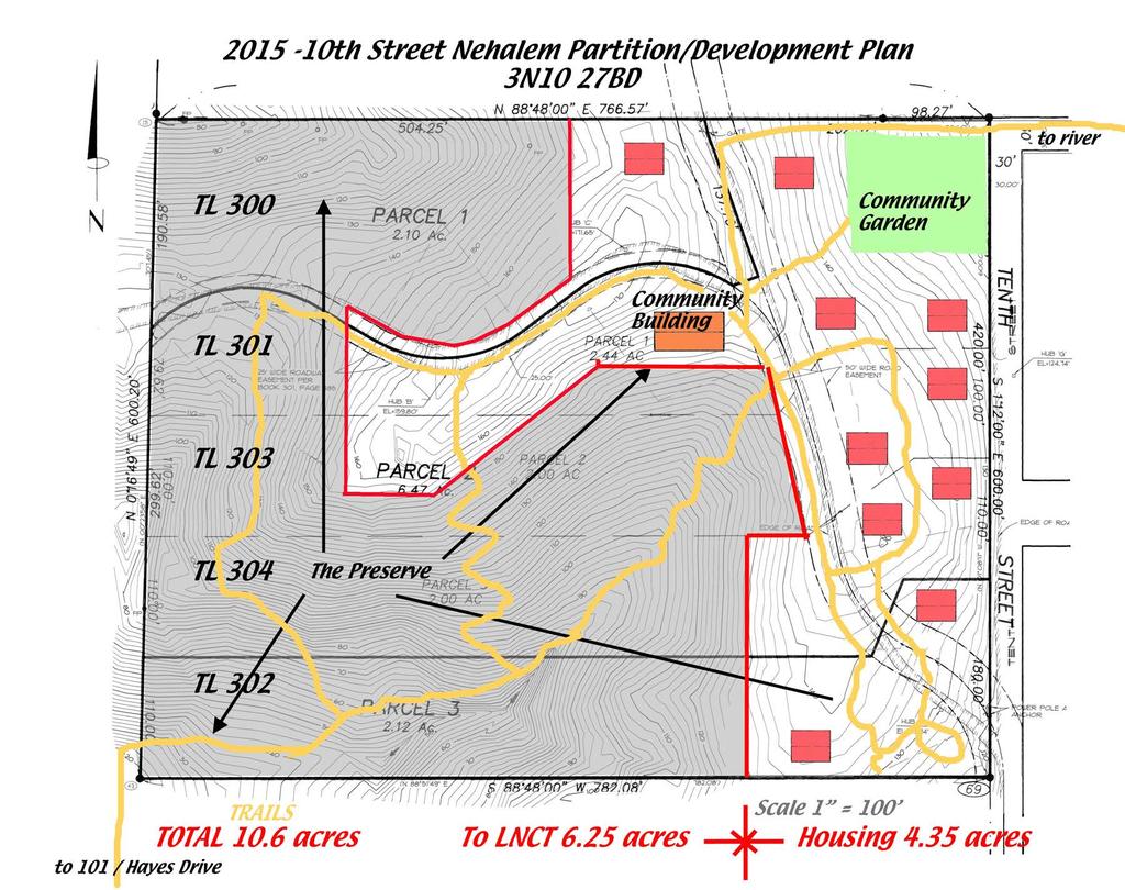
2 PROPOSED FINDINGS OF FACT BENDER URBAN GROWTH BOUNDARY EXPANSION AND ANNEXATION REQUEST April 3, 2016 Background The owners of TL300, 301, 302, 303, and 304, 3N1027BD - properties abutting the City Limits of Nehalem west of 10th St and north of B St., request that the City of Nehalem expand its UGB to include those properties per the attached map, and annex that area into the City. The requested zoning is the abutting RM Medium Density Residential zone, as it is consistent with existing city zoning, allows normal residential uses, and establishes conditional use review of potential special siting needs. A group of local residents wishes to establish a Senior Citizens Aging in Place facility in Nehalem. This is a new kind of needed housing which promises better quality of life for aging seniors and can help improve the affordability of housing for a major segment of the community. This group of tax lots is well suited to meet the locational needs, listed below. The project will occupy just over 4 acres, with living units comprised of shared and individual dwellings, clustering the dwellings and shared services in the optimum part of the property. Homes will be offered as studio to 2- bedroom. Price range for living units will be $ k. All living units will be owned by residents. The development will include common facilities for the community to share, and include a community house with commercial kitchen, dining room, laundry, library/quiet space and guest space; a woodshop/workshop and art studio; and sports/equiipment storage. A community garden, walking paths, open space and outdoor parking, and other amenities are proposed. The overall area of these taxlots is 10.6 acres. The western 6.25 acres, containing a ravine of old growth trees, is proposed for donation to the Lower Nehalem Community Trust, and can provide open space for the project. If retained as part of the project, deed restrictions will be put in place to prevent further development in that area. It will be privately owned and no burden to the city. The remaining 4.35 acres will be used for housing, including a.7 acre existing easement granted to the City of Nehalem for access to the city water storage tank. Subtracting space for the existing community garden, outdoor parking and storage, the community house and walking paths, leaves 77,000 sq.ft. for housing, which can accommodate 10 duplex lots with up to 20 living units. 1
3 CONFORMANCE WITH CITY OF NEHALEM COMPREHENSIVE PLAN POLICIES: Section Citizen Involvement Goal 1. To provide all city residents an opportunity to be involved in the City s planning decisions. In accordance with Policies 1 through 5, the proposal is consistent with the policies in that public hearings are required at both the City and County Planning Commissions and governing bodies, and will be carried out in accordance with Oregon law. Section Comprehensive Plan Procedure The process is intended to conform to both the City and Tillamook County requirements for Comprehensive Plan amendments. Section Natural Features Goal 1. To foster high quality development consistent with the natural environment. The proposal is to develop a small portion of the property and leave over 6 acres in perpetual open space. The residential and common uses will be built on the east side of the property closer to existing residential uses. The development will be of high quality, designed by an architect and built to respect the natural environment. Section Recreation and Open Space The 6.25 acres of open space to be dedicated to the Land Trust will contain hiking trails for residents of the development as well as the general public. The development will maintain a community garden for residents and other amenities, and the North Coast Recreation District facilities are nearby. Section Air and Water Quality Goal 1. To maintain, and where necessary, improve the City s air and water resources. The development will protect air quality by clustering development on a small portion of the property, and by preserving old growth trees on the over six acres to be donated to the land trust. Homeowners will be able to walk to many services such as the recreation center and the commercial area in downtown Nehalem. Construction will take place with care so as to avoid erosion and sedimentation. 2
4 Section Housing Goal 1. To provide for housing which will meet the needs of a variety of age and income groups. Policy 1. The City will zone adequate land to meet identified future housing needs for a broad range of housing types. This identified housing need has specified characteristics for suitable land: * Land above MSLs shown in tsunami inundation map and global warming map from the BLI, to avoid natural hazards such as tsunami inundation and global warming to eliminate need for for seniors to evacuate * Flat enough topography for accessible housing * Affordable * Non- resource land, non- wetland * Having power and city water immediately available, solar access for energy * Minimal impact on utility needs with energy/water- efficient designs available for the property permitting major reduction in energy use. * Being within 2 blocks of the school, senior meals, post office, community center, and emergency evacuation center * Close to the downtown and urgent care facilities * Proximity to sewer, schools, etc. Only these Tax Lots 300 have capability of meeting these criteria as the site for this project. Tax lots 300 have 4 sewer access points within 400', new city water lines transecting the property, a PUD substation abutting on the west with undergrounded power lines on site, and good solar access. The UGB must be based on the adopted 20- year population forecast for the urban area described in OAR , and must provide for needed housing. See ORS below, for definition of needed housing. It establishes that gross land availability is not adequate to meet housing needs, but that the availability of land to provide housing at all needed price and rent levels is required. The 2007 Buildable Lands Inventory showed a severe shortage of land availability at prices needed to provide housing for a major proportion of the community. This was even more clearly shown by the "last 12 months" actual market analysis that we performed in conjunction with the study. The BLI results demonstrated a shortage of needed land at prices necessary to meet the need of 40% or 70% of the community. Current demographic information indicates a median age of 52.8 years for Nehalem residents in contrast to Oregon's 38.4 years. Residents age 60+ are 41% of the city population. Housing for seniors has special needs - locational, accessibility, proximity, security, and is an identified need in the community. 3
5 The Aging in Place concept is gaining popularity across the country, but has not been widely used on the Oregon Coast. These taxlots are the only property that can satisfy this need. It is well away from areas subject to tsunami or global warming threats, is close to services, has good views and good solar access. Section Economics Goal 1. Improve the Economic Base of the Community The development of up to 20 housing units will be built by local contractors using locally sourced materials, and add several million dollars to the City s tax base. The dwellings will be owned and occupied by permanent residents who will contribute to the local economy in many ways. The land is not being used for or is suitable for forestry or agriculture, or needed for commercial or industrial use. Section Energy Goal 1. To conserve energy. The project will be designed to be sustainable utilizing energy efficient construction, including solar panels to generate electricity. Section Transportation Goal 1. To provide and encourage a safe, convenient and economic transportation system. The location is within easy walking distance of many services and commercial areas, as well as bus stops for public transportation. It will not require development of new roads or access points onto US 101. Section Urban Growth Boundary Goal 1. Coordinate land use, development and annexation strategies with Tillamook County. The application has been made jointly to the City of Nehalem and Tillamook County. Conversion of Resource Lands The property is zoned rural residential in Tillamook County, and is not currently being used for agricultural or forestry purposes. Therefore, no exception to Goals 3 or 4 would be necessary. The portion to be donated to the Land Trust will remain as a forest for habitat protection and recreation, including a trail system. 4
6 Site Suitability The property is better suited to the purposes allowed by the proposed change than it is to the purposes of the existing zone. The increased density will benefit the City of Nehalem by increasing the assessed value of the City and providing more affordable housing options. The forested area is very steep and accessible from other Land Trust properties, and the cleared area is adjacent to an existing residential area and committed to development. Impact on Legally Designated Uses of Neighboring Properties The proposed development will be compatible with surrounding development, including the City s water reservoir and neighboring residences. The City and TPUD will retain easements across the property. Residents will utilize 10 th Street for vehicular traffic, and will be able to walk to downtown. CONFORMANCE WITH OAR 660+ ORS : OAR 660, Div (1): "must provide for needed housing" This request for UGB expansion is for a specific category of needed housing (Senior Aging in Place) that has been identified nationally since the last Nehalem Comprehensive Plan update. * The Benefits of Aging in Place, Jane B. Clark, Kiplinger, Aug * Measuring the Costs and Savings of Aging in Place, HUD USER, Fall 2013 * 8 Smart Ideas People Have Had About Aging In Place, HuffPost, March 2015 * As senior population grows, aging in place gains popularity: Communities conducting outreach, The Nation's Health, Oct Nehalem's median age = 52.8 years, vs. Oregon's 38.4 years. (US Census Bureau) Residents age 60+ = 41% of Nehalem population (US Census Bureau) Nehalem, Manzanita and Wheeler cities have an estimated population of age 60+ years of 419 people. (US Census Bureau) 0040(3): A local government may review and amend the UGB in consideration of one category of land need (for example, housing need) without a simultaneous review and amendment in consideration of other categories of land need (for example, employment need). This request is to amend the UGB in consideration of one specific category of land need - for Senior Aging in Place housing. This identified housing need has specified characteristics for suitable land: 5
7 * Land above MSLs shown in tsunami inundation map and global warming map from the BLI, to avoid natural hazards such as tsunami inundation and global warming to eliminate need for seniors to evacuate * Flat enough topography for accessible housing * Affordable land cost * Non- resource land, non- wetland * Having power and city water immediately available, solar access for energy * Minimal impact on utility needs, with energy/water- efficient designs available for the property permitting major reduction in energy use * Being within 2 blocks of the school, senior meals, post office, community center, emergency evacuation center, swimming pool, theater * Close to the downtown and urgent care facilities * Proximity to sewer, schools, etc. 0050: (1) When evaluating or amending a UGB, a local government must inventory land inside the UGB to determine whether there is adequate development capacity to accommodate 20- year needs determined in OAR For residential land, the buildable land inventory must include vacant and redevelopable land, and be conducted in accordance with OAR or , whichever is applicable, and ORS for local governments subject to that statute. There is no land inside the UGB which meets the locational needs (above) for this category of needed housing: REVIEW OF AVAILABLE LAND: A review was made of Vacant and Partially Vacant Parcels, Buildable Lands and Zoning, and Buildable Land and Environmental Restraints from the 2007 Buildable Lands Inventory, plus the Tsunami Inundation and Global Warming maps from the BLI, and also MLS listings of vacant property in the Nehalem area since Inside the UGB: Bayside Gardens and areas west of the City Limits were excluded because of lack of proximity, wetlands, and potential flooding. The Northfork Rd. area beyond the city limits was excluded because of lack of proximity, some potential flooding, and steep slopes. The area south of Hugo Lane was excluded because of lack of proximity, slope and stability issues. Nehalem Point also already exceeds the number of allowable homes for its single access road, and remaining lots are unaffordable to build on. Parcels remaining with potential area for this housing need included Hilltop Estates Tract C & D and Hilltop Estates Replat 3N1027AB. These parcels exceed the desired distance from community facilities, and have some stability and access durability issues. They do not have access roads required for additional housing. Extensive new electric distribution lines would be needed from the TPUD substation. 6
8 The Kline parcel brought into city in 2015 is Forest Preserve, and is excluded from this use (Parcel 1 and Parcel 2 of Partition Plat ). (4) If the inventory demonstrates that the development capacity of land inside the UGB is inadequate to accommodate the estimated 20- year needs determined under OAR , the local government must amend the plan to satisfy the need deficiency, either by increasing the development capacity of land already inside the city or by expanding the UGB, or both, and in accordance with ORS where applicable. Prior to expanding the UGB, a local government must demonstrate that the estimated needs cannot reasonably be accommodated on land already inside the UGB. Review (above) of land already inside the city that does meet the locational requirements of this land use is already developed and in small parcels not viable for the need. Available land inside the UGB does not meet locational requirements for the need (above). (5) When land is added to the UGB, the local government must assign appropriate urban plan designations to the added land, consistent with the need determination. The local government must also apply appropriate zoning to the added land consistent with the plan designation, or may maintain the land as urbanizable land either by retaining the zoning that was assigned prior to inclusion in the boundary or by applying other interim zoning that maintains the land's potential for planned urban development until the land is rezoned for the planned urban uses. The RM zone (same as neighboring properties) meets these specific project needs at standard urban density, and allows for conditional use review to accommodate specific detailed project needs as project's physical plan is refined Boundary Location Alternatives Analysis: (1) When considering a UGB amendment, a local government must determine which land to add by evaluating alternative boundary locations. This determination must be consistent with the priority of land specified in ORS and the boundary location factors of Goal 14, as follows: (a) Beginning with the highest priority of land available, a local government must determine which land in that priority is suitable to accommodate the need deficiency determined under (b) If the amount of suitable land in the first priority category exceeds the amount necessary to satisfy the need deficiency, a local government must apply the location factors of Goal 14 to choose which land in that priority to include in the UGB. 7
9 (c) If the amount of suitable land in the first priority category is not adequate to satisfy the identified need deficiency, a local government must determine which land in the next priority is suitable to accommodate the remaining need, and proceed using the same method specified in subsections (a) and (b) of this section until the land need is accommodated. (e) For purposes of this rule, the determination of suitable land to accommodate land needs must include consideration of any suitability characteristics specified under section (5) of this rule, as well as other provisions of law applicable in determining whether land is buildable or suitable. (2) Notwithstanding OAR (4) and subsection (1)(c) of this rule, except during periodic review or other legislative review of the UGB, a local government may approve an application under ORS to for a UGB amendment proposing to add an amount of land less than necessary to satisfy the land need deficiency determined under OAR (4), provided the amendment complies with all other applicable requirements. (3) The boundary location factors of Goal 14 are not independent criteria. When the factors are applied to compare alternative boundary locations and to determine the UGB location, a local government must show that all the factors were considered and balanced. (4) In determining alternative land for evaluation under ORS , "land adjacent to the UGB" is not limited to those lots or parcels that abut the UGB, but also includes land in the vicinity of the UGB that has a reasonable potential to satisfy the identified need deficiency. (5) If a local government has specified characteristics such as parcel size, topography, or proximity that are necessary for land to be suitable for an identified need, the local government may limit its consideration to land that has the specified characteristics when it conducts the boundary location alternatives analysis and applies ORS The specified characteristics for this identified need are stated above. The only properties which meets those characteristics are those identified in this application. Taxlots 300 have 4 sewer access points within 400', new city water lines transecting the property, a PUD substation abutting on the west with undergrounded power lines on site, and good solar access. Taxlots 300 meet exactly the area requirements of the identified housing need. The only other parcels outside the UGB with potential proximity are Taxlots 900, 3N1027. These parcels exceed the desired distance from community facilities, and do not have sewer access. We were informed by the city that these properties do not have legal access and are therefore excluded from consideration. 8
10 UGB Adjustments (1) A local government may adjust the UGB at any time to better achieve the purposes of Goal 14 and this division. Such adjustment may occur by adding or removing land from the UGB, or by exchanging land inside the UGB for land outside the UGB. The requirements of Goal 14, this division, and ORS apply when land is added to the UGB, including land added in exchange for land removed. The requirements of ORS may also apply when land is added to a UGB, as specified in that statute. ORS : Priority of land to be included within urban growth boundary (1) In addition to any requirements established by rule addressing urbanization, land may not be included within an urban growth boundary except under the following priorities: (a) First priority is land that is designated urban reserve land under ORS (Urban reserves), rule or metropolitan service district action plan. (b) If land under paragraph (a) of this subsection is inadequate to accommodate the amount of land needed, second priority is land adjacent to an urban growth boundary that is identified in an acknowledged comprehensive plan as an exception area or nonresource land. Second priority may include resource land that is completely surrounded by exception areas unless such resource land is high- value farmland as described in ORS (High- value farmland description for ORS ). Nehalem has no urban reserve land nor exception areas. These 10th St properties are nonresource land. ATTACHMENTS: 1. Legal description of property 2. Survey of existing partitions of property 3. LNCT/10th St schematic partition 4. 10th St. Proximity to Nehalem resources for seniors Manzanita Tsunami Inundation Map BLI Global Warming Inundation for Nehalem 9
11
12
13


14 Proximity of 10th St. properties (labeled "Neahcasa Land") to Nehalem resources for seniors: 2012 Manzanita Tsunami Inundation Map:

15 Nehalem Global Warming Inundation of Nehalem UGB, from appendix of 2007 Buildable Lands Inventory:
NeahCasa. 10th Street Sustainable Neighborhood Project An on-the-ground collaborative demonstration of a higher level of green affordable housing
 NeahCasa PO Box 766, Manzanita OR 97130 www.neahcasa.org 10th Street Sustainable Neighborhood Project An on-the-ground collaborative demonstration of a higher level of green affordable
City of Astoria Comprehensive Plan URBAN GROWTH
 URBAN GROWTH CP.110 CP.110. Background Summary. Astoria has a population of 9,477 (2010 US Census). The total land area within the Urban Growth Boundary (UGB) is 3,474.2 acres with total land area of 4,450
8/17/16 PC Meeting 1
 1 GENERAL INFORMATION OWNER/APPLICANT: Thomas Corff & Terry Moberly (1943 13 th St.) 19328 Towercrest Dr. Oregon City, OR 97045 Michael & Jill Parker (1983 13 th St.) 1708 Oak St. Lake Oswego, OR 97034
EXHIBIT B FINDINGS OF FACT BEND DEVELOPMENT CODE (BDC) UPDATE AMENDMENT PZ
 UPDATE AMENDMENT PZ") EXHIBIT B FINDINGS OF FACT BEND DEVELOPMENT CODE (BDC) UPDATE AMENDMENT PZ 18-0524 Procedural Findings Notice of the proposed amendments was provided to the Department of Land Conservation and Development
EXHIBIT B FINDINGS OF FACT BEND DEVELOPMENT CODE (BDC) UPDATE AMENDMENT PZ 18-0524 Procedural Findings Notice of the proposed amendments was provided to the Department of Land Conservation and Development
CITY OF MEDFORD COMPREHENSIVE PLAN BUILDABLE LAND INVENTORY
 CITY OF MEDFORD COMPREHENSIVE PLAN PREPARED BY CITY OF MEDFORD PLANNING DEPARTMENT 200 SOUTH IVY STREET MEDFORD, OREGON 97501 BIANCA PETROU, A.I.C.P., ACTING PLANNING DIRECTOR LONG RANGE PLANNING SECTION
Planned Unit Development (PUD). Sections:
. Sections:") Chapter 19.07. Planned Unit Development (PUD). Sections: 19.07.01. Purpose. 19.07.02. PUD Definition and Design Compatibility. 19.07.03. General PUD Standards. 19.07.04. Underlying Zones. 19.07.05. Permitted
Chapter 19.07. Planned Unit Development (PUD). Sections: 19.07.01. Purpose. 19.07.02. PUD Definition and Design Compatibility. 19.07.03. General PUD Standards. 19.07.04. Underlying Zones. 19.07.05. Permitted
LAND USE PLANNING. General Discussion. Objectives
 GOAL 2: LAND USE PLANNING General Discussion To establish a land use planning process for the County as a basis for all decisions and actions related to use of land and to ensure an adequate factual base
CHAPTER 50 LAND USE ZONES ARTICLE 50 BASIC PROVISIONS
 CHAPTER 50 LAND USE ZONES ARTICLE 50 BASIC PROVISIONS 50.010 - PURPOSE The purposes of this chapter are to establish land use zones required to implement the goals and policies of the Klamath County Comprehensive
78th OREGON LEGISLATIVE ASSEMBLY Regular Session. House Bill 2510 SUMMARY
 th OREGON LEGISLATIVE ASSEMBLY--0 Regular Session Sponsored by Representative CLEM (Presession filed.) House Bill 0 SUMMARY The following summary is not prepared by the sponsors of the measure and is not
CHAPTER 3. APPLICATION REVIEW AND DECISION
 CHAPTER 3. APPLICATION REVIEW AND DECISION 3.1 LAND USE PERMITS/DECISIONS... 1 3.1.1 General Provisions... 1 A) Land Use Permits Required... 1 B) Effect of Approval... 1 C) Zoning Information Sheet...
LAND USE APPLICATION - ADMINISTRATIVE Property Line Adjustment Review (Ministerial No Notice)
") LAND MANAGEMENT DIVISION Date Received: LAND USE APPLICATION - ADMINISTRATIVE Property Line Adjustment Review (Ministerial No Notice) PUBLIC WORKS DEPARTMENT 3050 N. DELTA HWY, EUGENE OR 97408 Planning:
LAND MANAGEMENT DIVISION Date Received: LAND USE APPLICATION - ADMINISTRATIVE Property Line Adjustment Review (Ministerial No Notice) PUBLIC WORKS DEPARTMENT 3050 N. DELTA HWY, EUGENE OR 97408 Planning:
Appendix J - Planned Unit Development (PUD)
") Appendix J - Planned Unit Development (PUD) Intent and Purpose The purpose of the PUD is: 1. To provide development that is consistent with the Comprehensive Land Use Plan and promote the goals and objectives
Appendix J - Planned Unit Development (PUD) Intent and Purpose The purpose of the PUD is: 1. To provide development that is consistent with the Comprehensive Land Use Plan and promote the goals and objectives
Amendment to the Zoning and Subdivision Ordinances; Consider Repeal Cluster Development Standards
 2 Board of Supervisors Meg Bohmke, Chairman Gary F. Snellings, Vice Chairman Jack R. Cavalier Thomas C. Coen L. Mark Dudenhefer Wendy E. Maurer Cindy C. Shelton February 28, 2018 Thomas C. Foley County
Chapter 4: Housing and Neighborhoods
 Chapter 4: Housing and Neighborhoods Introduction Medina is a growing community that provides a variety of housing types and neighborhood styles while protecting and enhancing the City s open spaces and
STAFF REPORT. Permit Number: Unlimited. Kitsap County Board of Commissioners; Kitsap County Planning Commission
 STAFF REPORT Permit Number: 15 00550 Unlimited DATE: March 2, 2016 TO: FROM: Kitsap County Board of Commissioners; Kitsap County Planning Commission Katrina Knutson, AICP, Senior Planner, DCD and Jeff
Chapter 100 Planned Unit Development in Corvallis Urban Fringe
 100.100 Scope and Purpose. Chapter 100 Planned Unit Development in Corvallis Urban Fringe (1) All applications for land divisions in the Urban Residential (UR) and Flood Plain Agriculture (FPA) zones within
2005 COTTAGE GROVE BUILDABLE LANDS ANALYSIS UPDATE
 2005 COTTAGE GROVE BUILDABLE LANDS ANALYSIS UPDATE Adopted June 13, 2005 Prepared by Satre Associates, P.C. Planners, Landscape Architects and Environmental Specialists 132 East Broadway, Suite 536 Eugene,
CITY OF PENSACOLA AFFORDABLE HOUSING INCENTIVE PLAN
 1. BACKGROUND CITY OF PENSACOLA AFFORDABLE HOUSING INCENTIVE PLAN The Sadowski Affordable Housing Act as approved by the Florida Legislature and codified as Chapter 420 of the Florida Statutes requires
PLANNED UNIT DEVELOPMENTS
 PLANNED UNIT DEVELOPMENTS SECTION 9.01 DESCRIPTION AND PURPOSE. A. The purpose of a planned unit development (PUD) is to permit greater flexibility in development than is generally possible under standard
Article Optional Method Requirements
 Article 59-6. Optional Method Requirements [DIV. 6.1. MPDU DEVELOPMENT IN RURAL RESIDENTIAL AND RESIDENTIAL ZONES Sec. 6.1.1. General Requirements... 6 2 Sec. 6.1.2. General Site and Building Type Mix...
ARTICLE 15 - PLANNED UNIT DEVELOPMENT
 Section 15.1 - Intent. ARTICLE 15 - PLANNED UNIT DEVELOPMENT A PUD, or Planned Unit Development, is not a District per se, but rather a set of standards that may be applied to a development type. The Planned
5.03 Type III (Quasi-Judicial) Decisions
 Decisions") 5.03 Type III (Quasi-Judicial) Decisions 5.03 General Requirements A. The purpose of this Section is to identify what types of actions are considered Type III decisions. Type III decisions involve significant
5.03 Type III (Quasi-Judicial) Decisions 5.03 General Requirements A. The purpose of this Section is to identify what types of actions are considered Type III decisions. Type III decisions involve significant
GENERAL DESCRIPTION STAFF RECOMMENDATION IMPLEMENTATION REQUIREMENTS
 Application No.: 891418 Applicant: AREA-WIDE MAP AMENDMENT Rezone two parcels from Moderate Density Single Family (MSF) to Neighborhood Center (NC) and Employment Center (EC). Charles Bitton GENERAL DESCRIPTION
Rule 80. Preservation of Primary Agricultural Soils Revised and approved by the Land Use Panel during its public meeting on January 31, 2006.
 Rule 80. Preservation of Primary Agricultural Soils Revised and approved by the Land Use Panel during its public meeting on January 31, 2006. (A) Purpose. In accordance with 10 V.S.A. Sections 6025(b)
Burlington Unincorporated Community Plan
 Burlington Unincorporated Community Plan June 30, 2010 Meeting Page 1 of 24 Table of Contents (Page numbers to be inserted) I. Background a. Location and Community Description b. Planning of Unincorporated
1105 SUBDIVISIONS, PARTITIONS, REPLATS, CONDOMINIUM PLATS, AND VACATIONS OF RECORDED PLATS
 1105 SUBDIVISIONS, PARTITIONS, REPLATS, CONDOMINIUM PLATS, AND VACATIONS OF RECORDED PLATS 1105.01 PURPOSE AND APPLICABILITY Section 1105 is adopted to provide standards, criteria, and procedures under
610 LAND DIVISIONS AND PROPERTY LINE ADJUSTMENTS OUTSIDE A UGB
 ARTICLE VI: LAND DIVISIONS AND PROPERTY LINE ADJUSTMENTS VI-21 610 LAND DIVISIONS AND PROPERTY LINE ADJUSTMENTS OUTSIDE A UGB 610-1 Property Line Adjustments (Property Line Relocation) A property line
Business Item Community Development Committee Item:
 Business Item Community Development Committee Item: 2008-124 C Meeting date: July 21, 2008 ADVISORY INFORMATION Date: May 21, 2008 Subject: Flexible Residential Development Ordinance Guidelines District(s),
1. Future Land Use FLU6.6.8 Land uses within the Rural Service Area portion of the Wekiva Study Area shall be limited to very low and low intensity
 1. Future Land Use FLU6.6.8 Land uses within the Rural Service Area portion of the Wekiva Study Area shall be limited to very low and low intensity uses to the greatest extent possible. Existing land uses
Special Use Permit - Planned Unit Development Checklist. Property Address:
 Special Use Permit - Planned Unit Development Checklist Special Use Permit Number. Parcel Code/s #28-11- - - Property Address: Applicant: ARTICLE VIII Ordinance Reference - Section 8.1.2 Permit Procedures:
THE COMPREHENSIVE PLAN FOR JOSEPHINE COUNTY (October 2005)
") THE COMPREHENSIVE PLAN FOR JOSEPHINE COUNTY (October 2005) GOALS AND POLICIES GOAL I: TO PRESERVE AND MAINTAIN AGRICULTURAL LANDS AND THE RURAL CHARACTER OF JOSEPHINE COUNTY OVERVIEW: The rate of population
THE COMPREHENSIVE PLAN FOR JOSEPHINE COUNTY (October 2005) GOALS AND POLICIES GOAL I: TO PRESERVE AND MAINTAIN AGRICULTURAL LANDS AND THE RURAL CHARACTER OF JOSEPHINE COUNTY OVERVIEW: The rate of population
SUPPLEMENTAL APPLICATION Lot of Record Dwelling (Agricultural Zoned Land) (January 2018) APPLICANT INFORMATION
 (January 2018) APPLICANT INFORMATION") CLACKAMAS COUNTY PLANNING AND ZONING DIVISION DEPARTMENT OF TRANSPORTATION AND DEVELOPMENT DEVELOPMENT SERVICES BUILDING 150 BEAVERCREEK ROAD OREGON CITY, OR 97045 503-742-4500 ZONINGINFO@CLACKAMAS.US
CLACKAMAS COUNTY PLANNING AND ZONING DIVISION DEPARTMENT OF TRANSPORTATION AND DEVELOPMENT DEVELOPMENT SERVICES BUILDING 150 BEAVERCREEK ROAD OREGON CITY, OR 97045 503-742-4500 ZONINGINFO@CLACKAMAS.US
Buildable Lands Analysis within the Overall UGB Expansion Process
 CHAPTER 3. BUILDABLE LANDS ANALYSIS The buildable lands inventory is intended to identify lands that are available for development within the UGB. The inventory is sometimes characterized as supply of
ARTICLE III District Regulations. A map entitled "Franklin Zoning Map" is hereby adopted as part of this chapter 1.
 ARTICLE III District Regulations ~ 305-8. Adoption of Zoning Map. A map entitled "Franklin Zoning Map" is hereby adopted as part of this chapter 1. ~ 305-9. Official Zoning Map; amendments. Regardless
SECTION 16. "PUD" PLANNED UNIT DEVELOPMENT OVERLAY DISTRICT
 SECTION 6. "PUD" PLANNED UNIT DEVELOPMENT OVERLAY DISTRICT Subsection. Purpose. This district is established to achieve the coordinated integration of land parcels and large commercial and retail establishments
DRAFT Plan Incentives. Part A: Basic Discount
 DRAFT 2030 Plan Incentives July 26, 2006 Part A: Basic Discount In order for a development to be eligible for any 2030 Land Resource Management Plan Discounts it must be located in the Urban Corridor and
FIGURE 29: RECOMMENDED COMPETITIVE LARGE LOT INDUSTRIAL INVENTORY TOTAL SHORT TERM Number of Sites Jurisdictions 3 2 1
 MEMORANDUM DATE: MARCH 12, 2013 TO: FROM: SUBJECT: CITY OF REDMOND 716 SW Evergreen Avenue Community Development Department Redmond, OR 97756 (541) 923-7721 Fax: (541) 548-0706 www.ci.redmond.or.us CITY
KLAMATH COUNTY PLANNING DEPARTMENT Government Center 305 Main St., Klamath Falls, Oregon Phone Option #4 Fax
 KLAMATH COUNTY PLANNING DEPARTMENT Government Center 305 Main St., Klamath Falls, Oregon 97601 Phone 541-883-5121 Option #4 Fax 541-885-3644 Land Partition Application Submittal Requirements (Please include
B. Subarea Provisions, including the Design Elements and Area of Special Concern and Potential Park/Open Space/Recreation Requirements;
 ARTICLE III: LAND USE DISTRICTS III-1 300 INTRODUCTION Article III of the Washington County Community Development Code consists of the primary and overlay districts which apply to the unincorporated areas
Planning Department Oconee County, Georgia
 Planning Department Oconee County, Georgia STAFF REPORT REZONE CASE #: 6985 DATE: October 31, 2016 STAFF REPORT BY: Andrew C. Stern, Planner APPLICANT NAME: Williams & Associates, Land Planners PC PROPERTY
Residential Project Convenience Facilities
 Standards for Specific Land Uses 35.42.220 E. Findings. The review authority shall approve a Land Use Permit in compliance with Subsection 35.82.110.E (Findings required for approval) or a Conditional
HOUSING & RESIDENTIAL AREAS
 CHAPTER 10: HOUSING & RESIDENTIAL AREAS OVERVIEW With almost 90% of Ridgefield zoned for residential uses, the patterns and form of residential development can greatly affect Ridgefield s character. This
-- its location within the City of Bandon s Urban Growth Boundary but outside the city s current city limits in unincorporated Coos County;
 P a g e 1 Memo to Oregon Solutions Donut Hole work group From Al Johnson Re: Land Use Context 1 August 28, 2017 The 225-acre area of gorse-infested land known as the Bandon Donut Hole presents a variety
THE REDEVELOPMENT PLAN
 PAGE 37 THE REDEVELOPMENT PLAN FUTURE LAND USE The Silver Terrace Redevelopment Area is currently designated as Redevelopment Area #4 on the City of Delray Beach Future Land Use Map (FLUM). This designation
Title 6 - Local Government Provisions Applicable to Special Purpose Districts and Other Political Subdivisions
 Title 6 - Local Government Provisions Applicable to Special Purpose Districts and Other Political Subdivisions CHAPTER 29. SOUTH CAROLINA LOCAL GOVERNMENT COMPREHENSIVE PLANNING ENABLING ACT OF 1994 1994
CHAPTER URBAN TRANSITION - UT ZONE
 CHAPTER 16.13 URBAN TRANSITION - UT ZONE Section Title Page 16.13.000 Purpose 1 16.13.010 Uses 1 16.13.020 Conditional Uses 2 16.13.030 Conditional Use Criteria 3 16.13.040 Prohibited Uses 4 16.13.100
CCC XXX Rural Neighborhood Conservation (NC)
") CCC 33.10.XXX Rural Neighborhood Conservation (NC) Purpose: Maintain low density rural residential areas and associated uses commonly found in rural areas consistent with the local character of the distinctive
CCC 33.10.XXX Rural Neighborhood Conservation (NC) Purpose: Maintain low density rural residential areas and associated uses commonly found in rural areas consistent with the local character of the distinctive
SECTION CLASSIFICATION OF ZONES For the purpose of this Code the following primary land use zoning districts are hereby established:
 ARTICLE 4 ZONING DISTRICTS SECTION 4.010 CLASSIFICATION OF ZONES For the purpose of this Code the following primary land use zoning districts are hereby established: Primary Zones Abbreviated Designation
Minutes of a Regular Meeting of the Development Review Board Held on the fifth day of December, 2018
 Minutes of a Regular Meeting of the Development Review Board Held on the fifth day of December, 2018 Members Present: Member(s) Absent: Others Present: Chairman Craig Powers, Vice Chair Orland Campbell,
WASCO COUNTY PRELIMINARY SUBDIVISION APPLICATION
 WASCO COUNTY PRELIMINARY SUBDIVISION APPLICATION DETAILED SPECIFIC WRITTEN REQUEST File Number: SDV- Number of Proposed Lots & their Dimensions: PRELIMINARY SUBDIVISION PLAN REQUIREMENTS The approval of
2030 General Plan. December 6, 7 pm
 2030 General Plan GPAC Meeting #9 GPAC Meeting #9 December 6, 7 pm City Council Input on Working Draft Land Use Map Council discussed GPAC & PC versions of the working draft land use map 11/28 Council
STAFF REPORT. Community Development Director PO Box 4755 Beaverton, OR 97076
 STAFF REPORT HEARING DATE: July 7, 2010 TO: Planning Commission STAFF: Jana Fox, Assistant Planner PROPOSAL: Southeast Beaverton Office Commercial Zoning Map Amendment (ZMA2010-0006) LOCATION: The subject
FOREST DWELLING PERMIT APPLICATION. Other: APPLICANT: Name: Mailing address: Phone No.: Office Home. Name: Mailing Address: Phone No.
 FOREST DWELLING PERMIT APPLICATION TYPE: Lot of Record Template Large/Multi Tract Other: APPLICANT: Name: Mailing address: City State Zip Code Phone No.: Office Home Are you the property owner? owner's
NOTICE OF ADOPTED CHANGE TO A COMPREHENSIVE PLAN OR LAND USE REGULATION
 NOTICE OF ADOPTED CHANGE TO A COMPREHENSIVE PLAN OR LAND USE REGULATION Date: Jurisdiction: Local file no.: DLCD file no.: May 17, 2016 City of Lebanon 16-02-09 002-16 The Department of Land Conservation
STAFF REPORT. Arthur and Kathleen Quiggle 4(b)
") STAFF REPORT Application: Requests related to the construction of a 28' x 41' dwelling and 6' wrap-around open deck to replace an existing 24' x 32' cabin and wrap-around open deck and the installation
STAFF REPORT Application: Requests related to the construction of a 28' x 41' dwelling and 6' wrap-around open deck to replace an existing 24' x 32' cabin and wrap-around open deck and the installation
ARTICLE V AGRICULTURAL PRESERVATION AND RURAL RESIDENTIAL DISTRICT
 ARTICLE V AP AGRICULTURAL PRESERVATION AND RURAL RESIDENTIAL DISTRICT Section 500. PURPOSE It is the purpose of the AP, Agricultural Preservation and Rural Residential District, to foster the preservation
City of Creswell DRAFT Residential Buildable Lands Inventory
 City of Creswell DRAFT Residential Buildable Lands Inventory REVISED DRAFT - AUGUST 2007 Creswell Residential Buildable Land Inventory Page 1 Creswell Residential Buildable Land Inventory Page 2 Table
Chapter 210 CONDITIONAL USES
 Chapter 210 CONDITIONAL USES 210.01 Purpose 210.02 Authorization 210.03 Process Type 210.04 Determination of Major or Minor Conditional Use Review 210.05 Approval Criteria 210.06 Conditions of Approval
Draft Zoning Changes for the 2nd Planning Board Public Hearing, January 22, 2018.
 Draft Zoning Changes for the 2nd Planning Board Public Hearing, January 22, 2018. No changes were made at the 1st Public Hearing. Proposed wording for the 1 st Public Hearing in red, eliminated text in
ARTICLE VII. NONCONFORMITIES. Section 700. Purpose.
 ARTICLE VII. NONCONFORMITIES. Section 700. Purpose. The purpose of this chapter is to regulate and limit the development and continued existence of legal uses, structures, lots, and signs established either
Chapter Planned Residential Development Overlay
 Chapter 19.29 Planned Residential Development Overlay Sections 010 Purpose 020 Scope 030 Definitions 030 Minimum Size 040 Allowable Uses 050 Minimum Development Standards 060 Density Bonus 070 Open Space
FINAL DRAFT 12/1/16, Rev. to 7/18/17
 FINAL DRAFT 12/1/16, Rev. to 7/18/17 (As Adopted 8/8/17 Effective 9/1/17) SHELTON PLANNING AND ZONING COMMISSION Proposed Amendments to Zoning Regulations I. Amend Section 23 PERMITTED USES by inserting
3.1. OBJECTIVES FOR RESIDENTIAL LAND USE DESIGNATIONS GENERAL OBJECTIVES FOR ALL RESIDENTIAL DESIGNATIONS
 3. RESIDENTIAL LAND USE DESIGNATIONS INTRODUCTION The Residential land use designations provide for housing and other land uses that are integral to, and supportive of, a residential environment. Housing
Interpretation of Conservation Purpose INTERNAL REVENUE GUIDANCE AS TO WHAT CONSTITUES A CONSERVATION PURPOSE
 Interpretation of Conservation Purpose INTERNAL REVENUE GUIDANCE AS TO WHAT CONSTITUES A CONSERVATION PURPOSE 170(h)(4)(A) of Title 26, Internal Revenue Code, Subtitle A of the United States Code gives
URBANIZATION ELEMENT. PREPARED BY CITY OF MEDFORD PLANNING DEPARTMENT 200 SOUTH IVY STREET MEDFORD, OREGON
 PREPARED BY CITY OF MEDFORD PLANNING DEPARTMENT 200 SOUTH IVY STREET MEDFORD, OREGON 97501 plnmed@ci.medford.or.us ROBERT O. SCOTT, AICP, PLANNING DIRECTOR COMPREHENSIVE PLANNING SECTION MARK GALLAGHER,
STAFF REPORT. Permit Number: Gonzalez. Kitsap County Board of Commissioners; Kitsap County Planning Commission
 STAFF REPORT Permit Number: 15 00657 Gonzalez DATE: March 2, 2016 TO: FROM: Kitsap County Board of Commissioners; Kitsap County Planning Commission Katrina Knutson, AICP, Senior Planner, DCD and Jeff Arango,
Guide to Preliminary Plans
 Guide to Preliminary Plans Introduction The Douglas County is committed to providing open, transparent application processes to the public. This Guide is provided to assist anyone interested in the procedures
ORDINANCE NUMBER O- (NEW SERIES) DATE OF FINAL PASSAGE
 DATE OF FINAL PASSAGE") ORDINANCE NUMBER O- (NEW SERIES) DATE OF FINAL PASSAGE AN ORDINANCE OF THE COUNCIL OF THE CITY OF SAN DIEGO AMENDING CHAPTER 14, ARTICLE 3, DIVISION 7, BY AMENDING SECTIONS 143.0710, 143.0715, 143.0720,
ORDINANCE NUMBER O- (NEW SERIES) DATE OF FINAL PASSAGE AN ORDINANCE OF THE COUNCIL OF THE CITY OF SAN DIEGO AMENDING CHAPTER 14, ARTICLE 3, DIVISION 7, BY AMENDING SECTIONS 143.0710, 143.0715, 143.0720,
ARTICLE B ZONING DISTRICTS
 ARTICLE B ZONING DISTRICTS Sec. 8-3021 Established. In order to protect the character of existing neighborhoods; to prevent excessive density of population in areas which are not adequately served with
Conservation & Development Policies: The Plan for Connecticut
 2013-2018 Conservation & Development Policies: The Plan for Connecticut CT Land Conservation Council March 21, 2015 www.ct.gov/opm/cdplan CT s Planning Framework State statutes include three separate,
Open Space Model Ordinance
 Open Space Model Ordinance Section I. Background Open space development has numerous environmental and community benefits, including: 1) Reduces the impervious cover in a development. Impervious cover
Annutteliga Hammock Project Surplus and Consolidation Strategy
 Project Overview Annutteliga Hammock is a 31,250-acre partnership acquisition project of the Florida Forever program, of which 12,231 acres have been acquired to date. The intent of the project is to provide
SUBDIVISION, PLANNED UNIT DEVELOPMENT, ZONING AMENDMENT, & SIDEWALK WAIVER STAFF REPORT Date: July 19, 2018
 SUBDIVISION, PLANNED UNIT DEVELOPMENT, ZONING AMENDMENT, & SIDEWALK WAIVER STAFF REPORT Date: July 19, 2018 NAME SUBDIVISION NAME LOCATION West Mobile Properties, LLC U.S. Machine Subdivision 556, 566,
PLANNING COMMISSION REPORT Regular Agenda -Public Hearing Item
 PDP-13-00518 Item No. 3B- 1 PLANNING COMMISSION REPORT Regular Agenda -Public Hearing Item PC Staff Report 2/24/14 ITEM NO. 3B PRELIMINARY DEVELOPMENT PLAN FOR HERE @ KANSAS; 1101 INDIANA ST (SLD) PDP-13-00518:
TOWN OF MIDDLEBOROUGH COMMUNITY PRESERVATION PLAN
 TOWN OF MIDDLEBOROUGH COMMUNITY PRESERVATION PLAN Vision The residents of Middleborough desire a community which is family-oriented and which retains its small town character while preserving an abundance
TOWNSHIP OF ALGOMA. County, Michigan, held in the Algoma Township Hall, Algoma Avenue, N.E., within
 TOWNSHIP OF ALGOMA COUNTY OF KENT, MICHIGAN At a special meeting of the Township Board of the Township of Algoma, Kent County, Michigan, held in the Algoma Township Hall, 10531 Algoma Avenue, N.E., within
1. an RSF-R, RSF-1, RSF-2, RSF-4, RMF-5, or RMF-8 zoning district; or
 Chapter 9 INCENTIVES 9.1 General 9.1.1 Review and Approval Procedure Projects requesting bonuses under this chapter for land that has not been platted, or for land that is being voluntarily replatted,
Prepared By: 03/20/2013. feet EFU RR-5. Zoning. Taxlots. Subject UR-1. Information is deemed reliable but not guaranteed. RR-5
 Prepared By: 03/20/2013 Ü 0 260 feet EFU RR-5 Zoning Taxlots UR-1 Subject Terri Dr David Ln RR-5 Information is deemed reliable but not guaranteed. CHAPTER 5. ZONE DISTRICTS 5.1 GENERAL PROVISIONS... 1
NC General Statutes - Chapter 106 Article 61 1
 Article 61. Agricultural Development and Preservation of Farmland. Part 1. General Provisions. 106-735. Short title, purpose, and administration. (a) This Article shall be known as "The Agricultural Development
Attachment A First Submittal JAZB Safety Zones A and B
 Attachment A First Submittal JAZB Safety Zones A and B Attachment B Second Submittal JAZB Safety Zones A and B Attachment C Flying Cloud Airport (FCM) Draft Airport Zoning Ordinance Social and Economic
Planning Department Oconee County, Georgia STAFF REPORT
 Planning Department Oconee County, Georgia STAFF REPORT REZONE CASE #: 7332 DATE: November 28, 2017 STAFF REPORT BY: Gabriel Quintas, Planner APPLICANT NAME: Smith Planning Group PROPERTY OWNER: John Hadden
Umatilla County Department of Land Use Planning
 Umatilla County Department of Land Use Planning 216 SE 4 th ST, Pendleton, OR 97801, (541) 278-6252 Property Line Adjustment, Type V Application & Information Packet PROCESSING THE APPLICATION The application
8Land Use. The Land Use Plan consists of the following elements:
 8Land Use 1. Introduction The Land Use Plan consists of the following elements: 1. Introduction 2. Existing Conditions 3. Opportunities for Redevelopment 4. Land Use Projections 5. Future Land Use Policies
Multiple Use Forest District (MUF)
") This district is defined as Multiple Use Forest District with a minimum lot size of 20 acres. 11.15.2162 Purposes The purposes of the Multiple Use Forest District are to conserve and encourage the use
This district is defined as Multiple Use Forest District with a minimum lot size of 20 acres. 11.15.2162 Purposes The purposes of the Multiple Use Forest District are to conserve and encourage the use
CHAPTER 3 PRELIMINARY PLAT
 10-3-1 10-3-3 SECTION: CHAPTER 3 PRELIMINARY PLAT 10-3-1: Consultation 10-3-2: Filing 10-3-3: Requirements 10-3-4: Approval 10-3-5: Time Limitation 10-3-6: Grading Limitation 10-3-1: CONSULTATION: Each
Land Use. Existing Land Use
 8 Land Use 8.1 Land Use Chapter Purpose and Contents This element includes a brief summary of existing land use conditions and trends followed by a series of goals, objectives, and recommendations to guide
Section 7.22: Multifamily Assisted Housing in AA-30 Residential Zone (MAHZ) [Note: an additional line will be added to the Table in Article 3, 3.1.
 [Note: an additional line will be added to the Table in Article 3, 3.1.") Section 7.22: Multifamily Assisted Housing in AA-30 Residential Zone (MAHZ) [Note: an additional line will be added to the Table in Article 3, 3.1.1A] 7.22.1 Purpose The purpose of this Special Regulation
Section 7.22: Multifamily Assisted Housing in AA-30 Residential Zone (MAHZ) [Note: an additional line will be added to the Table in Article 3, 3.1.1A] 7.22.1 Purpose The purpose of this Special Regulation
ARTICLE IV: DEVELOPMENT STANDARDS
 ARTICLE IV: DEVELOPMENT STANDARDS IV-53 409 PRIVATE STREETS A private street means any way that provides ingress to, or egress from, property by means of vehicles or other means, or that provides travel
1. Cuyler-Brownsville planned neighborhood conservation (P-N-C) districtphase I (section ). (2) Single-family semiattached dwellings;
 districtphase I (section ). (2) Single-family semiattached dwellings;") Sec. 8-3035. Planned unit development multifamily (PUD-M). A. Purpose. The PUD-M district is intended to allow a variety of residential development including single-family residential, two-family residential,
Sec. 8-3035. Planned unit development multifamily (PUD-M). A. Purpose. The PUD-M district is intended to allow a variety of residential development including single-family residential, two-family residential,
RATE STUDY IMPACT FEES PARKS
 RATE STUDY FOR IMPACT FEES FOR PARKS CITY OF KENMORE, WASHINGTON May 15, 2001 TABLE OF CONTENTS Executive Summary................................................... 1 1. Statutory Basis and Methodology
Article 6: Planned Unit Developments
 LUDC 2013 GARFIELD COUNTY, COLORADO Article 6: Planned Unit Developments ARTICLE 6 PLANNED UNIT DEVELOPMENTS TABLE OF CONTENTS DIVISION 1. GENERAL.... 1 6-101. GENERAL PROVISIONS.... 1 A. Purpose....
Conservation Design Subdivisions
 Conservation Design Subdivisions An excerpt from the Rules and Regulations Governing Division of Land in Sheridan County, Wyoming, November 5, 2010 Sheridan County Public Works Department 224 S. Main Street
STAFF REPORT. Permit Number: Porter. Kitsap County Board of Commissioners; Kitsap County Planning Commission
 STAFF REPORT Permit Number: 15 00461 Porter DATE: November 9, 2015 TO: FROM: Kitsap County Board of Commissioners; Kitsap County Planning Commission Katrina Knutson, AICP, Senior Planner, DCD and Jeff
PLANNING COMMISSION REPORT Regular Agenda Public Hearing Item CONDITIONAL USE PERMIT FOR VERIZON WIRELESS; 1287 E 1200 RD (SLD)
") PC Staff Report 9/26/2016 CUP-16-00312 Item No. 5-1 PC Staff Report 9/26/2016 ITEM NO. 5 PLANNING COMMISSION REPORT Regular Agenda Public Hearing Item CONDITIONAL USE PERMIT FOR VERIZON WIRELESS; 1287
PC Staff Report 9/26/2016 CUP-16-00312 Item No. 5-1 PC Staff Report 9/26/2016 ITEM NO. 5 PLANNING COMMISSION REPORT Regular Agenda Public Hearing Item CONDITIONAL USE PERMIT FOR VERIZON WIRELESS; 1287
PLANNING COMMISSION REPORT Regular Agenda Public Hearing Item
 PC Staff Report 11/12/12 Item No. 2B- 1 PLANNING COMMISSION REPORT Regular Agenda Public Hearing Item ITEM NO. 2B: A TO GPI; 110 ACRES; E OF K-10 & N OF W 6 TH ST (MKM) : Consider a request to rezone approximately
Metropolitan Planning Commission. DATE: April 5, 2016
 TO: FROM: Metropolitan Planning Commission MPC Staff DATE: April 5, 2016 SUBJECT: Petition of Nine Line Inc. Robert McCorkle, Agent PIN: 2-1034-01-002 380.5 Acres Aldermanic District: 5 (Shabazz) County
4.2 LAND USE INTRODUCTION
 4.2 LAND USE INTRODUCTION This section of the EIR addresses potential impacts from the Fresno County General Plan Update on land use in two general areas: land use compatibility and plan consistency. Under
PIN , Part 1, Plan SR-713 in Lot 2, Concession 5, Township of McKim (1096 Dublin Street, Sudbury)
") STAFF REPORT Applicant: Dalron Construction Limited Location: PIN 02124-0103, Part 1, Plan SR-713 in Lot 2, Concession 5, Township of McKim (1096 Dublin Street, Sudbury) Official Plan and Zoning By-law:
STAFF REPORT Applicant: Dalron Construction Limited Location: PIN 02124-0103, Part 1, Plan SR-713 in Lot 2, Concession 5, Township of McKim (1096 Dublin Street, Sudbury) Official Plan and Zoning By-law:
Item No Halifax and West Community Council July 10, 2018
 P.O. Box 1749 Halifax, Nova Scotia B3J 3A5 Canada Item No. 10.1.2 Halifax and West Community Council July 10, 2018 TO: Chair and Members of Halifax and West Community Council SUBMITTED BY: Original signed
Subject: Ordinance 1657, Annexation of 3.55 acres of land at 3015 and 3001 Parker Road.
 Agenda Report 2016-12-12-09 Date: December 8, 2016 To: From: Russ Axelrod, Mayor Members, West Linn City Council Jennifer Arnold, Planning Department Through: John Boyd, Interim Community Development Director