Alberta Flood Hazard Identification Program
|
|
|
- Arthur Cole
- 5 years ago
- Views:
Transcription


1 Alberta Flood Hazard Identification Program Peter Onyshko, P.Eng., CFM River Forecast Section Alberta Environment and Parks November 5, 2015
2 Flood Hazard Identification Program Presentation Outline Introduction Flood Hazard Identification Program (FHIP) History Objectives Principles Flood Hazard Mapping Terminology Design Flood Flood Hazard Area Floodway and Flood Fringe Program Standards Existing Flood Hazard Studies
3 Flood Hazard Identification Program Presentation Outline New River Hazard Studies 5 New Studies Upper Bow, Bow and Elbow, Highwood, Sheep, and Peace River Hazard Studies Study Areas Hydrology Assessment Survey & Base Data Collection Hydraulic Modelling Flood Inundation Mapping Flood Hazard Mapping New Study Components
4 Flood Hazard Identification Program Introduction Flooding: Can occur along all rivers and streams in Alberta Has the potential to cause damage to property, hardship to people and in extreme events, loss of life Damages can represent one of the largest expenses for the public, local authorities, and both provincial and federal disaster assistance programs Identifying and understanding flood hazards is the first step in any program to reduce flood damages


5 OVER 14,500 HOMES DAMAGED 10 HEALTH FACILITIES DAMAGED 80 SCHOOLS DAMAGED 30 COMMUNITIES IMPACTED 985 KM ROADS CLOSED 3,000 BUSINESSES AFFECTED PEOPLE EVACUATED
6 Flood Hazard Identification Program History Flood hazard mapping began in the 1970s Canada-Alberta Flood Damage Reduction Program (FDRP) began in 1989 to standardize and cost-share flood hazard mapping studies a 10 year program The Government of Alberta has continued to create flood hazard mapping for communities since 1999 with the Flood Hazard Identification Program (FHIP) Joint Federal-Provincial FDRP focused on urban areas
7 Flood Hazard Identification Program Objectives Increase public safety and awareness of flood hazards Promote appropriate development of flood hazard areas Reduce future flood damages and related financial costs
8 Flood Hazard Identification Program Principles Floods are natural events and severe floods can occur in any year We have a responsibility to reduce flood hazards within our areas of jurisdiction, and have a role in managing flood hazard areas through appropriate land-use planning Development in flood hazard areas should not result in an unacceptable level of risk to residents, the development, or the environment Flood hazard studies and maps identify an existing flood hazard, they do not create them
9 Flood Hazard Mapping Terminology Design Flood A flood that has a 1% chance of occurring each year Referred to as the 100-year flood, but this does not mean that it will only occur once every 100 years Can be an open water flood or an ice jam flood Determined by hydrologic assessment when a study is conducted

10 Flood Hazard Mapping Terminology Flood Hazard Area Total area inundated by the design flood Divided into zones Floodway Flood Fringe


11
12 Flood Hazard Mapping Defining the Floodway The portion of the flood hazard area where flows are deepest, fastest and most destructive Includes the main channel of a stream and typically a portion of the adjacent floodplain area Typically located where design flood waters: are 1 m deep or greater are flowing at 1 m/s velocity or higher
13 Flood Hazard Mapping Defining the Flood Fringe The portion of the flood hazard area not included in the floodway, but still inundated in design flood event Typically has shallower water and lower velocities during the design flood event Assumed to be fully developed in the future development will not increase design flood levels above that calculated and mapped

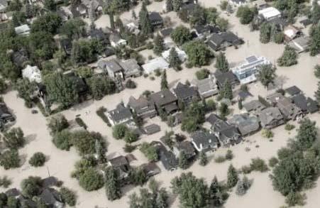
14 Calgary Bow Elbow Bow
15 Flood Hazard Mapping Current Program Standards Mapping and regulation to floodway levels Design flood levels encroached floodway levels are applied to entire flood hazard area Incorporates potential future development impact Recommend no new obstruction of floodway Future floodway development regulations Flood-proofing recommended to design flood level plus a locally-set freeboard Freeboard not directly incorporated into mapping
16 Flood Hazard Mapping Current Program Standards Dykes considered functionally ineffective FHIP Guidelines: When delineating a flood hazard area, any dyking present is assumed to be ineffective and the flooded area behind the dyke would be considered floodway or flood fringe. This is a conservative assumption but it reflects the potential flood hazard if the dykes were to fail. Dykes mitigate risk but do not eliminate hazard No dyke certification program

17 Naturalized design discharge Oldman Dam, 1995
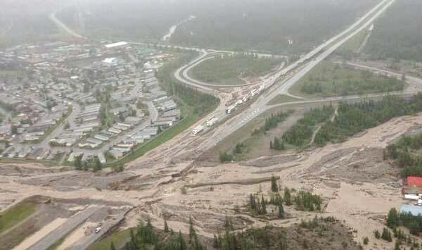
18 High River
19 Flood Hazard Mapping Existing Flood Hazard Studies Black Diamond and Turner Valley Sheep River 1992 Bragg Creek Elbow River and Bragg Creek 1992 Canmore Bow River and Policeman Creek 1993 Calgary Bow and Elbow Rivers 1983, revised 1996 and 2012 Cochrane Bow River, Bighill and Jumpingpound Creeks 1986, revised 1990 High River Highwood River, Baker Creek and Little Bow River 1992 MD of Bighorn and Exshaw Bow River and Exshaw Creek 1996 Okotoks Sheep River 1996, revised 2013 Rocky View County - Elbow River and Lott Creek 1996, revised 1998 Flood mapping for these studies will be replaced.
20 New River Hazard Studies 500+ km Bow 200 km Calgary Elbow 70 km Peace 50 km Sheep 80 km Highwood 100 km
21 New River Hazard Studies Hydrology Assessment Basin-wide hydrology assessments in a parallel study Assessing over 85 locations in new river hazard study areas as well as upstream and downstream Including tributaries not part of current mapping plan Including 2013 flood flows and 2014/2015 data in the new analysis, with option to add 2016 flows Naturalized and regulated flow scenarios Flow frequency estimates stripping out man-made regulation and including current regulation by dams
22 New River Hazard Studies Survey and Base Data Collection River and Ground Data Collection Surveyed River Cross Sections Digital Terrain Model (DTM), typically based on LiDAR


23 New River Hazard Studies Survey and Base Data Collection Hydraulic & Flood Control Structure Data Collection Bridges & Culverts Berms & Dykes Aerial Imagery Acquisition Highwater Mark Surveys Inglewood Flood Wall, Calgary Red Deer River

24 New River Hazard Studies Hydraulic Modelling Create a computer hydraulic model (HEC-RAS) representing the river Survey Data Digital Terrain Model Hydraulic models calibrated using historic highwater marks 2D modelling to inform the 1D models will be completed in parts of Calgary and High River Models calculate water levels for different floods, including the design flood
25 New River Hazard Studies Flood Inundation Mapping Flood levels computed by hydraulic model are transferred to base mapping to delineate areas at risk from flooding Previous Flood Hazard Studies mapped 10-, 50-, 100-year floods New River Hazard Studies will map 2-, 5-, 10-, 20-, , 75-, 100-, 200-, 350-, 500-, 750-, and 1000-year open water floods Maps show the inundated extent for 13 flood scenarios Primarily used by stakeholders in emergency response planning and preparation Based on flood inundation mapping completed as part of Alberta-Calgary partnership projects in 2012 and 2015

26 Inundation 5-Year Flood 2012 Study
27 Inundation 10-Year Flood 2012 Study
28 Inundation 20-Year Flood 2012 Study
29 Inundation 50-Year Flood 2012 Study

30 Inundation 100-Year Flood 2012 Study

31 New River Hazard Studies Flood Hazard Mapping Hydraulic model determines design flood water levels Design flood based on the naturalized 100-year flood Maps the flood hazard area, the area flooded by the design flood Divided into Floodway and Flood Fringe using current standards
32 New River Hazard Studies New Study Components Flood Risk Assessment & Inventory Inventory of land parcels, buildings, infrastructure, and population in floodplain Various flood scenarios will be used to identify infrastructure and population at risk Channel Stability Investigation Delineates historical and current channel bank locations Identifies areas where river migration is occurring

33 Any questions?
Chapter 5. Floodplain Management. 5.0 Introduction. 5.1 Floodplain Management and Regulation
 5.0 Introduction This chapter summarizes the Town s rules and regulations regarding floodplain management and development. The requirements presented in this chapter should be used by the design engineer
Chapter 5. Floodplain Management. 5.0 Introduction. 5.1 Douglas County Comprehensive Master Plan. 5.2 Floodplain Management and Regulation
 5.0 Introduction This chapter summarizes the County s rules and regulations regarding floodplain management and development. The requirements presented in this chapter should be used by the design engineer
HEC Software and FEMA Submittals
 HEC Software and FEMA Submittals EWRI Workshop HEC Users Conference Larry Voice Risk Analysis FEMA Region VI April 12, 2010 Overview Flood Hazard Analysis Overview of Map Changes Accepted Model List Guidance
SECTION 10: FLOOD HAZARD EVALUATION 10-1
 10) SECTION 10: FLOOD HAZARD EVALUATION A. General. Land subject to being flooded by a Flood of 100-Year Frequency as defined by Title 76, Chapter 5, MCA, or land subject to flooding pursuant to these
FLOOD HAZARD AREA LAND USE MANAGEMENT
 FLOOD HAZARD AREA LAND USE MANAGEMENT Introduction Guidance For Selection of Qualified Professionals and Preparation of Flood Hazard Assessment Reports This document is intended to provide guidance for
FLOODWAY DEVELOPMENT REGULATION
 Floodway Development Regulation Task Force Discussion Paper FLOODWAY DEVELOPMENT REGULATION Dated: August 20, 2014 Table of Contents 1. Introduction... 3 2. General Background... 3 3. List of Task Force
CITY OF CAMBRIDGE FLOODPLAIN MANAGEMENT CHAPTER 7 (GRADING, EROSION AND SEDIMENT CONTROL)
") CITY OF CAMBRIDGE FLOODPLAIN MANAGEMENT CHAPTER 7 (GRADING, EROSION AND SEDIMENT CONTROL) City of Cambridge, MD Floodplain Management Ordinance (Tidal): May, 2011 1 City of Cambridge, Maryland Floodplain
CITY OF CAMBRIDGE FLOODPLAIN MANAGEMENT CHAPTER 7 (GRADING, EROSION AND SEDIMENT CONTROL) City of Cambridge, MD Floodplain Management Ordinance (Tidal): May, 2011 1 City of Cambridge, Maryland Floodplain
Mingo County, WV Community Coordination Preliminary Flood Insurance Study and Flood Insurance Rate Map. Thursday, September 25, 2014
 Mingo County, WV Community Coordination Preliminary Flood Insurance Study and Flood Insurance Rate Map Thursday, September 25, 2014 Overview Preliminary Materials Preliminary FIS Report Digital Flood Insurance
REGIONAL DISTRICT OF NANAIMO BYLAW NO. 1469
 REGIONAL DISTRICT OF NANAIMO BYLAW NO. 1469 A BYLAW TO ESTABLISH FLOODPLAINS, CONSTRUCTION LEVELS IN FLOODPLAINS, AND SETBACKS FOR LANDFILL AND STRUCTURES IN FLOODPLAINS WHEREAS Section 910 of the Local
DIVISION 1. - GENERAL PROVISIONS
 Sec. 90-708. - Statutory authorization and purpose. Sec. 90-709. - Applicability. Sec. 90-710. - Compliance and liability. Sec. 90-711. - Records. Sec. 90-712. - Abrogation and greater restrictions. Sec.
The Drainage Control Regulations
 1 The Drainage Control Regulations Repealed by Saskatchewan Regulations 89/2015 (effective October 16, 2015) Formerly Chapter D-33.1 Reg 1 (effective August 18, 1981) as amended by Saskatchewan Regulations
Appendix E: Hydrologic & Hydraulic Report. Proposed Bridge Replacement SR 1008, Section 02B (Henry Road) Over Bushkill Creek
 Over Bushkill Creek") Hydrologic & Hydraulic Report Proposed Bridge Replacement SR 1008, Section 02B (Henry Road) Over Bushkill Creek Appendix E: Existing Conditions Hydraulic Analysis 425 Bushkill Creek Henry Woods WS 500-yr
Hydrologic & Hydraulic Report Proposed Bridge Replacement SR 1008, Section 02B (Henry Road) Over Bushkill Creek Appendix E: Existing Conditions Hydraulic Analysis 425 Bushkill Creek Henry Woods WS 500-yr
Prepared by and to be returned to Linn County Planning & Development nd Street S.W., Cedar Rapids, Iowa (319)
") Prepared by and to be returned to Linn County Planning & Development 935 2 nd Street S.W., Cedar Rapids, Iowa 52404-2161 (319) 892-5130 LINN COUNTY, IOWA ZONING BOARD OF ADJUSTMENT IN THE MATTER OF THE
Prepared by and to be returned to Linn County Planning & Development 935 2 nd Street S.W., Cedar Rapids, Iowa 52404-2161 (319) 892-5130 LINN COUNTY, IOWA ZONING BOARD OF ADJUSTMENT IN THE MATTER OF THE
Oxford Floodplain Management Ordinance
 Table of Contents SECTION 1.0 GENERAL PROVISIONS...1 1.1 Findings...1 1.2 Statutory Authorization...1 1.3 Statement of Purpose...1 1.4 Areas to Which These Regulations Apply...2 1.5 Basis for Establishing
National Flood Insurance Program
 National Flood Insurance Program Base Flood Elevations in Zone A Streams Surveyor Training Presented by Thomas F. Smith, PE, PLS January 22, 2018 1 FEMA Region III Mitigation Division Floodplain Management
LUZERNE COUNTY ZONING ORDINANCE TEXT AMENDMENTS FLOOD PLAIN MANAGEMENT
 LUZERNE COUNTY ZONING ORDINANCE TEXT AMENDMENTS FLOOD PLAIN MANAGEMENT Eliminate in Article 11 DEFINITIONS The definitions of Flood, Flood- Fringe, Floodway, One Hundred Year Flood and One Hundred (100)
The Added Value of Geospatial Information in Disaster and Risk Management: A Case Study on the 2009 Flooding in Namibia
 The Added Value of Geospatial Information in Disaster and Risk Management: A Case Study on the 2009 Flooding in Namibia Summary Tessa Anne Belinfante, M.Sc. VU University Amsterdam Objective and Approach
For public hearing by the Town Council and Planning Commission March 24, 2014
 AN ORDINANCE TO AMEND SECTION 17.0 FLOOD HAZARD OVERLAY DISTRICT FH OF THE ZONING ORDINANCE OF THE TOWN OF SCOTTSVILLE, VIRGINIA BE IT ORDAINED by the Town Council of the Town of Scottsville, Virginia,
DEPARTMENT OF NATURAL RESOURCES FLOOD PLAIN CHAPTER 31, ARTICLE 10
 STATE OF NEBRASKA DEPARTMENT OF NATURAL RESOURCES FLOOD PLAIN CHAPTER 31, ARTICLE 10 DECEMBER 2003 TABLE OF CONTENTS CHAPTER 31, ARTICLE 10 FLOOD PLAIN Section Page 31-1001 Legislative findings; purpose
Developing Mitigation Projects. Molly J. O Toole, P.E., D.WRE, CFM
 Developing Mitigation Projects Molly J. O Toole, P.E., D.WRE, CFM Mitigation Hazard mitigation is defined as any sustained action taken to reduce or eliminate long-term risk to life and property from a
(Chapter Flood Damage Prevention)
") Chapter 13.10 Flood Damage Prevention Section: 13.10.010 Purpose and Policy 13.10.020 Definitions 13.10.030 Applicability and Areas of Special Flood Hazard 13.10.040 Administration 13.10.050 Provisions
Chapter 13.10 Flood Damage Prevention Section: 13.10.010 Purpose and Policy 13.10.020 Definitions 13.10.030 Applicability and Areas of Special Flood Hazard 13.10.040 Administration 13.10.050 Provisions
1. Survey Introduction
 1. Survey Introduction CITIZEN PREPAREDNESS QUESTIONNAIRE Chelan County has embarked on a planning process to reduce the adverse impacts of flood hazards. This effort is being implemented through the Community
Legal Description Part of the Western Half of the Eastern Half of the Northwest Quarter of Section 30, Le Ray Township
 Owner and Applicant s 20448 State Highway 83 Mankato, MN 56001 Request and Location Request for review and approval of a Conditional Use Permit to allow an Elder Care Residential Unit to be constructed
2016 Fredericksburg Area Floodplain Management Workshop Tuesday, October 25, 2016
 2016 Fredericksburg Area Floodplain Management Workshop Tuesday, October 25, 2016 Charley Banks, CFM Department of Conservation And Recreation Division of Dam Safety & Floodplain Management Some Soapbox
REQUEST FOR PROPOSALS
 REQUEST FOR PROPOSALS DAM BREAK INUNDATION ZONE STUDY AND MAPPING Town of Woodstock, VA The Town of Woodstock, Virginia is requesting proposals from engineering firms to perform Dam Break Inundation Studies
Overview of Federal and State Floodplain Management Programs
 Overview of Federal and State Floodplain Management Programs Peter DeMeo, PE Supervising Environmental Engineer New Jersey Department of Environmental Protection Division of Land Use Regulation October
LINCOLN COUNTY FLOOD DAMAGE PREVENTION ORDINANCE
 LINCOLN COUNTY FLOOD DAMAGE PREVENTION ORDINANCE SECTION 1.0 STATUTORY AUTHORIZATION, FINDINGS OF FACT, PURPOSE AND OBJECTIVES SECTION 2 DEFINITIONS SECTION 3.0 GENERAL PROVISIONS SECTION 4.0 ADMINISTRATION
VI. SAFETY ELEMENT I. INTRODUCTION A. PURPOSE B. AUTHORITY. 1. Safety
 AB 162 and SB 1241 Amendment to the Safety Element New sections are underlined, deleted sections are shown as strikethrough and the denotes text remaining in place. VI. SAFETY ELEMENT I. INTRODUCTION A.
FLOOD HAZARD AREA LAND USE MANAGEMENT GUIDELINES. May Ministry of Water, Land and Air Protection. Province of British Columbia
 FLOOD HAZARD AREA LAND USE MANAGEMENT GUIDELINES May 2004 Ministry of Water, Land and Air Protection Province of British Columbia Amended by: Ministry of Forests, Lands, Natural Resource Operations and
Section Flood Plain Management Districts
 1370.05 FLOOD PLAIN MANAGEMENT DISTRICTS Subd. 1 Statutory Authorization: The legislature of the State of Minnesota has, in Minnesota Statutes Chapter 103F and Chapter 462, delegated the responsibility
Schedule "A Fees (Planning Advisory Program)
") Approvals Fee Schedule (Effective January 1, 2018) Schedule "A Fees (Planning Advisory Program) - 2018 Planning Application Type Fee is for provision of comments to municipal approval authority on site
Approvals Fee Schedule (Effective January 1, 2018) Schedule "A Fees (Planning Advisory Program) - 2018 Planning Application Type Fee is for provision of comments to municipal approval authority on site
ESTES VALLEY STORMWATER MANAGEMENT PROGRAM
 ESTES VALLEY STORMWATER MANAGEMENT PROGRAM Phase I. Stormwater Master Plan Phase II. Stormwater Utility Feasibility Study Board of Realtors Meeting May 3, 2018 Stormwater Master Plan Summary Stormwater
ORDINANCE NO TOWNSHIP OF EAST WINDSOR COUNTY OF MERCER
 ORDINANCE NO. 2016-07 TOWNSHIP OF EAST WINDSOR COUNTY OF MERCER AN ORDINANCE REPEALING SECTION 22-4: FLOOD DAMAGE PREVENTION CODE, OF THE REVISED GENERAL ORDINANCES OF THE TOWNSHIP OF EAST WINDSOR AND
FEMA POLICY: GUIDANCE ON THE USE OF AVAILABLE FLOOD HAZARD INFORMATION
 FEMA POLICY: GUIDANCE ON THE USE OF AVAILABLE FLOOD HAZARD INFORMATION FEMA Policy #104-008-2 BACKGROUND The policy is for FEMA Headquarters, Regional program staff, and for the Field Staff at the Joint
Raines, Melton & Carella, Inc. Cost Estimating PRWFPA Staff Working Group Tim Harrison Lidia Gutierrez, Karen Frye September 15,
 PAJARO RIVER WATERSHED FLOOD PREVENTION AUTHORITY Phase 3: Conceptual Design of Soap Lake Preservation Project Phase 4a: Design Level Mapping Technical Support Technical Memorandum No. 3.7 Task: Cost Estimating
ORD-3309 BE IT ORDAINED BY THE CITY COUNCIL OF THE CITY OF VIRGINIA BEACH, VIRGINIA:
 ORD-3309 1 2 3 4 5 6 7 8 9 10 11 12 13 14 15 16 17 18 19 20 21 22 23 24 25 26 27 28 29 30 31 32 33 34 35 36 37 38 39 40 41 42 43 44 45 AN ORDINANCE TO ADOPT APPENDIX K, (FLOODPLAIN ORDINANCE) OF THE CITY
Flood Hazard Area Control Act Rules
 An Overview of New Jersey s Flood Hazard Area Control Act Rules State of New Jersey Department of Environmental Protection Chingwah Liang Why Regulate NJ s Floodplains? 1. New Jersey endures enormous
ARTICLE 18 TABLE OF CONTENTS TO THE FLOODPLAIN MANAGEMENT REGULATIONS
 Table of Contents Valley Center Floodplain Ordinance ARTICLE 18 TABLE OF CONTENTS TO THE FLOODPLAIN MANAGEMENT REGULATIONS Chapter 18.01 STATUTORY AUTHORIZATION, FINDINGS OF FACT & PURPOSES...1 18.01.01
Floodplain Management
 Chapter VIII Floodplain Management 1. Statutory Authorization, Findings of Fact, and Purpose A. Statutory Authorization The legislature of the State of Minnesota has, in Minnesota Statutes, chapters 103F
CHAPTER 24 F FLOOD ZONE OVERLAY DISTRICT
 CHAPTER 24 OVERLAY DISTRICT SECTION 24.01 PURPOSE It is the intent of this district to apply special regulation to the use of land in those areas subject to periodic inundation. Such regulation is deemed
SECTION 30- FP FLOOD PLAIN DISTRICT
 SECTION 30- FP FLOOD PLAIN DISTRICT This zoning district is created to be appended to or overlaid on another primary zoning district for the purpose of meeting the needs of the watercourses and drain ways
ARTICLE 16. FLOODPLAIN MANAGEMENT, EROSION AND SEDIMENT CONTROL, AND STORMWATER MANAGEMENT
 ARTICLE 16. FLOODPLAIN MANAGEMENT, EROSION AND SEDIMENT CONTROL, AND STORMWATER MANAGEMENT Title 1. DEFINITIONS AND GENERAL PROVISIONS 2. FLOODPLAIN MANAGEMENT 3. EROSION AND SEDIMENT CONTROL 4. STORMWATER
MASON COUNTY FLOODPLAIN ORDINANCE
 MASON COUNTY FLOODPLAIN ORDINANCE September 2013 AUTHORITY AND PURPOSE: AN ORDINANCE ESTABLISHING A FLOODPLAIN AREA AND REQUIRING ALL CONTRACTORS, PERSONS, PARTNERSHIPS, BUSINESSES, AND CORPORATIONS TO
MANSFIELD TOWNSHIP BURLINGTON COUNTY ORDINANCE
 MANSFIELD TOWNSHIP BURLINGTON COUNTY ORDINANCE 2017-15 AN ORDINANCE TO AMEND THE CODE OF THE TOWNSHIP OF MANSFIELD BY DELETING AND REPEALING CHAPTER 22 THEREOF, ENTITLED FLOOD DAMAGE PREVENTION, AND REPLACING
PROJECT SCOPE OF WORK CITY OF TOWN AND COUNTRY STORMWATER PROGRAM
 PROJECT SCOPE OF WORK CITY OF TOWN AND COUNTRY STORMWATER PROGRAM Project ID Number: 2-2 Problem: The backyards at 962, 97, and 978 Delvin Drive are located in a low area of shallow ponding that takes
BEAVER COUNTY, PENNSYLVANIA
 VOLUME 3 OF 3 BEAVER COUNTY, PENNSYLVANIA (ALL JURISDICTIONS) Beaver County COMMUNITY NAME COMMUNITY NUMBER COMMUNITY NAME COMMUNITY NUMBER ALIQUIPPA, CITY OF 420101 AMBRIDGE, BOROUGH OF 420102 BADEN,
STORMWATER MANAGEMENT ORDINANCE
 STORMWATER MANAGEMENT ORDINANCE AN AMENDED ORDINANCE REGULATING THE RATE AND VELOCITY OF STORMWATER DISCHARGE FROM PROPOSED DEVELOPMENTS WITHIN THE CITY OF MADISON AND REQUIREMENTS FOR STORMWATER RETENTION
MODEL FLOODPLAIN MANAGEMENT / FLOOD DAMAGE PREVENTION ORDINANCE
 MODEL FLOODPLAIN MANAGEMENT / FLOOD DAMAGE PREVENTION ORDINANCE Description: Floodplain management involves the designation of flood-prone areas and the managing of their uses. It is also aimed at minimizing
(Ord. No. 743, )
") CHAPTER 330. - FLOODPLAIN MANAGEMENT Section 330-1. - Purpose. (a) (b) (c) (d) It is hereby determined that the flood hazard areas of the City of Chamblee are subject to periodic inundation which may result
CHAPTER 330. - FLOODPLAIN MANAGEMENT Section 330-1. - Purpose. (a) (b) (c) (d) It is hereby determined that the flood hazard areas of the City of Chamblee are subject to periodic inundation which may result
CHAPTER 19 FLOODPLAIN ZONING
 CHAPTER 19 FLOODPLAIN ZONING 19.01 STATUTORY AUTHORIZATION, FINDING OF FACT, STATEMENT OF PURPOSE, TITLE AND GENERAL PROVISIONS (1) Statutory Authorization (2) Finding of Fact (3) Statement of Purpose
CHAPTER 109 NATURAL RESOURCES AND ENVIRONMENTAL PROTECTION. ARTICLE I. Flood Damage Prevention In General
 Sec. 109-1. - Authorization. CHAPTER 109 NATURAL RESOURCES AND ENVIRONMENTAL PROTECTION ARTICLE I. Flood Damage Prevention In General Article IX, Section II of the Constitution of the State of Georgia
FLOODPLAIN HAZARD MANAGEMENT REGULATIONS 2014 REGULATIONS COUNTY OF FALLON
 FLOODPLAIN HAZARD MANAGEMENT REGULATIONS 2014 REGULATIONS COUNTY OF FALLON & MONTANA DEPARTMENT OF NATURAL RESOURCES AND CONSERVATION WATER RESOURCES DIVISION 1424 9 TH Avenue P.O. Box 201601 Helena, Montana
Flood Plain Overlay District. Section Statutory Authorization, Findings of Fact and Purpose.
 Article X. Flood Plain Overlay District. Section 20-171. Statutory Authorization, Findings of Fact and Purpose. (a) Statutory Authorization. The legislature of the State of Minnesota has, in Minnesota
MN Floodplain Management Ordinance: 2012 City of Glyndon, Minnesota Two Districts - One-Map Format
 MN Floodplain Management Ordinance: 2012 City of Glyndon, Minnesota Two Districts - One-Map Format TABLE OF CONTENTS PAGE SECTION 1.0 STATUTORY AUTHORIZATION, FINDINGS OF FACT AND PURPOSE 1 1.1 Statutory
ROCKIES REALTY BANFF/CANMORE
 ROCKIES REALTY BANFF/CANMORE YEAR END REAL ESTATE NEWS 2013 I WELCOME YOUR REFERRALS Personal Perspective of the Year 2013 Page 1 Three Sisters Mountain Village Page 2 Summary of Sales Activity Page 2
Map Modernization Modernization Program
 FEMA Map Modernization Program Presented to Maryland Association of Floodplain and Stormwater Managers October 27, 2005 Map Modernization Program Autorun.exe 2 Map Modernization Program Outline Map Mod
WAYNE COUNTY, WV FLOODPLAIN ORDINANCE
 WAYNE COUNTY, WV FLOODPLAIN ORDINANCE AUTHORITY AND PURPOSE: AN ORDINANCE ESTABLISHING A FLOODPLAIN AREA AND REQUIRING ALL CONTRACTORS, PERSONS, PARTNERSHIPS, BUSINESSES, AND CORPORATIONS TO OBTAIN A PERMIT
PARK COUNTY FLOODPLAIN HAZARD MANAGEMENT REGULATIONS Effective March 30, Adoption Date March 30, 2017
 PARK COUNTY FLOODPLAIN HAZARD MANAGEMENT REGULATIONS Effective March 30, 2017 Adoption Date March 30, 2017 1 March 2017 TABLE OF CONTENTS SECTION 1. TITLE, PURPOSE, AUTHORITY AND GENERAL PROVISIONS 1.1
RENVILLE COUNTY LAND USE ORDINANCE CHAPTER NINE FLOOD PLAIN REGULATIONS SECTION 1. STATUTORY AUTHORIZATION, FINDINGS OF FACT, AND STATEMENT OF PURPOSE
 RENVILLE COUNTY LAND USE ORDINANCE CHAPTER NINE FLOOD PLAIN REGULATIONS SECTION 1. STATUTORY AUTHORIZATION, FINDINGS OF FACT, AND STATEMENT OF PURPOSE 1. Statutory Authorization. The legislature of the
The Board of Supervisors of the County of Riverside ordains as follows:
 ORDINANCE NO. 458 (AS AMENDED THROUGH 458.13) AN ORDINANCE OF THE COUNTY OF RIVERSIDE AMENDING ORDINANCE NO. 458 REGULATING FLOOD HAZARD AREAS AND IMPLEMENTING THE NATIONAL FLOOD INSURANCE PROGRAM The
Floodplain Development Land Use Review
 PUBLIC WORKS - COMMUNITY DEVELOPMENT 333 Broadalbin Street SW, PO Box 490, Albany, Oregon 97321-0144 BUILDING 541-917-7553 PLANNING 541-917-7550 Floodplain Development Land Use Review Application Information
29.01 STATUTORY AUTHORIZATION, FINDING OF FACT, STATEMENT OF PURPOSE, TITLE AND GENERAL PROVISIONS.
 Chapter 29 Floodplain Zoning Page 1 of 37 CHAPTER 29 FLOODPLAIN ZONING 29.01 STATUTORY AUTHORIZATION, FINDING OF FACT, STATEMENT OF PURPOSE, TITLE AND GENERAL PROVISIONS. (1) Statutory Authorization. This
Creek Rehabilitation Plan for Apple Valley Questions and Answers from the Pre-Bid Meeting and Site Visit 06/23/2016
 Questions and Answers from the Pre-Bid Meeting and Site Visit 06/23/2016 Q: What are the threatened and endangered species concerns in the area? A: This is potential habitat for Prebles Meadow Jumping
R-11. REPORT ON SUBDIVISION WITHIN THE AGRICULTURAL LANDRESERVE FILE NO. 212/2017 (Simpson) PEACE RIVER REGIONAL DISTRICT DEVELOPMENT SERVICES
 PEACE RIVER REGIONAL DISTRICT DEVELOPMENT SERVICES") PEACE RIVER REGIONAL DISTRICT DEVELOPMENT SERVICES REPORT ON SUBDIVISION WITHIN THE AGRICULTURAL LANDRESERVE FILE NO. 212/2017 (Simpson) OWNER: David A. Simpson DATE: October 19, 2017 AREA: Electoral Area
PEACE RIVER REGIONAL DISTRICT DEVELOPMENT SERVICES REPORT ON SUBDIVISION WITHIN THE AGRICULTURAL LANDRESERVE FILE NO. 212/2017 (Simpson) OWNER: David A. Simpson DATE: October 19, 2017 AREA: Electoral Area
River Road - Civil Design Report. Appendix D. Flood Hazard Map. Beca //04 August // NZ // page 38
 River Road - Civil Design Report Appendix D Flood Hazard Map Beca //04 August 2016 3124460 // NZ1-12891696-39 0.39 // page 38 Regional scale flood hazard mapping Waikato Regional Council holds regional
City of Fort Atkinson
 City of Fort Atkinson FLOODPLAIN ZONING ORDINANCE With Flood Storage Modifications February 4, 2015 ADOPTED by Fort Atkinson City Council November 18, 2014 ORDINANCE NO. 725 The City Council of the City
REGIONAL DISTRICT OF KITIMAT-STIKINE BYLAW NO. 656
 REGIONAL DISTRICT OF KITIMAT-STIKINE BYLAW NO. 656 A bylaw to designate land within the Regional District of Kitimat-Stikine as a floodplain, and to establish floodplain management procedures and regulations
Final Plats for Major Residential and Commercial Subdivisions Checklist
 Project Name: : This form is a checklist of Zoning Ordinance requirements for major residential and commercial subdivision plats to assist the applicant in their submittal. It is not intended to be a comprehensive
Current Issues in Managing Flood Protection Works in BC
 Current Issues in Managing Flood Protection Works in BC Electoral Area Directors Forum UBCM 2011 September 27, 2011 Bulkley River Dike Protects Houston BC - May 2011 Neil Peters P.Eng. Inspector of Dikes
ARMSTRONG COUNTY, PENNSYLVANIA
 ARMSTRONG COUNTY, PENNSYLVANIA (ALL JURISDICTIONS) Armstrong County COMMUNITY NAME COMMUNITY NUMBER APOLLO, BOROUGH OF 420092 APPLEWOLD, BOROUGH OF 420093 ATWOOD, BOROUGH OF 422297 BETHEL, TOWNSHIP OF
PRELIMINARY PLAT Application Packet
 PRELIMINARY PLAT Application Packet Community Development Department 1020 East Pioneer Road, Draper, UT 84020 (801) 576-6539 Fax (801) 576-6526 Dear Applicant, This application packet has been developed
Frequently Asked Questions for: Drainage, Watershed and Water Quality Property Owners Near Creeks Developers and Engineers and Definitions of Terms
 FREQUENTLY ASKED QUESTIONS Draft DEFINITIONS OF TERMS Last Revised July 2, 2008 Introduction: The following questions have been organized in the categories below. We have attempted to group the questions
Letter of Map Change Fundamentals
 Letter of Map Change Fundamentals FEMA Region III National Flood Insurance Program Essentials and Best Practices Jana Green, CFM, RAMPP Topics of Discussion Why Apply for a Letter of Map Change (LOMC)?
Fraser River Model Project fonds
 Fraser River Model Project fonds Compiled by Erwin Wodarczak (1998) Last revised November 2010 University of British Columbia Archives Table of Contents Fonds Description o Title / Dates of Creation /
Floodplain Management: New York State Role
 Floodplain Management: New York State Role Establish development/building standards State building code Model local law for flood damage prevention Provide technical assistance to local communities/agencies
BASICS OF FLOODPLAIN MANAGEMENT & PLANNING IN NEW JERSEY
 BASICS OF FLOODPLAIN MANAGEMENT & PLANNING IN NEW JERSEY STATE OF NEW JERSEY DEPARTMENT OF ENVIRONMENTAL PROTECTION VINCENT J. MAZZEI, JR., PE November 12, 2008 Flood Hazard Areas What is a 100-year flood?
***** Subchapter A. GENERAL PROVISIONS ***** PERMIT APPLICATIONS
 105.11. Permit requirements. 105.12. Waiver of permit requirements. Title 25 Environmental Protection Part I. Department of Environmental Protection Subpart C. Protection of Natural Resources Article I.
CHAPTER 16. ZONING AND PLANNING
 CHAPTER 16. ZONING AND PLANNING Article 1. Zoning Regulations Article 2. Floodplain Management Article 3. Subdivision Regulations Article 4. Comprehensive Land Use Plan ARTICLE 1. ZONING REGULATIONS 16-101.
BACKGROUND There are 23 flood control structures in the Upper Brushy Creek Water Control and Improvement District (District). See attached map.
. See attached map.") BACKGROUND There are 23 flood control structures in the Upper Brushy Creek Water Control and Improvement District (District). See attached map. The U.S Department of Agriculture - Natural Resources Conservation
BACKGROUND There are 23 flood control structures in the Upper Brushy Creek Water Control and Improvement District (District). See attached map. The U.S Department of Agriculture - Natural Resources Conservation
BLUESTONE DAM AN OVERVIEW NATIONAL INVENTORY OF DAMS ID: WV08902
 1 BLUESTONE DAM AN OVERVIEW NATIONAL INVENTORY OF DAMS ID: WV08902 237 237 237 217 217 217 200 200 200 0 0 0 163 163 163 131 132 122 Updated 10 October 2017 255 255 255 239 65 53 80 119 27 252 174.59 110
Allow continued use of existing grass runway for personal use by landowner.
 CUP-13-00193 Item No. 4-1 PLANNING COMMISSION REPORT Regular Agenda PC Staff Report 7/22/13 ITEM NO. 4: CONDITIONAL USE PERMIT; PRIVATE LANDING STRIP; 2215 N 500 (MKM) CUP-13-00193: Consider a Conditional
Criteria for Appeals of Flood Insurance Rate Maps. November 30, 201 1
 Criteria for Appeals of Flood Insurance Rate Maps November 30, 201 1 This document outlines the criteria for appealing proposed changes in flood hazard information on Flood Insurance Rate Maps (FIRMS)
GOVERNMENT CODE SECTION GOVERNMENT CODE SECTION 65302
 GOVERNMENT CODE SECTION 65300 65300. Each planning agency shall prepare and the legislative body of each county and city shall adopt a comprehensive, long-term general plan for the physical development
TITLE XV: LAND USAGE 150. BUILDING REGULATIONS; CONSTRUCTION 151. AIRCRAFT FLYWAY 152. FLOODPLAIN MANAGEMENT
 TITLE XV: LAND USAGE Chapter 150. BUILDING REGULATIONS; CONSTRUCTION 151. AIRCRAFT FLYWAY 152. FLOODPLAIN MANAGEMENT 153. ZONING 1 2 Warren - Land Usage CHAPTER 150: BUILDING REGULATIONS; CONSTRUCTION
NOTICE
 www.ketteringoh.org NOTICE This City of Kettering Code section is not the official version and is provided only for the convenience of the public. The only official version of the City of Kettering Code
Flood Mitigation in the NYC West-of-Hudson Watershed A guide to Programs, Agencies and Funding Sources for Municipalities and Property Owners
 Flood Mitigation in the NYC West-of-Hudson Watershed A guide to Programs, Agencies and Funding Sources for Municipalities and Property Owners In recent years, multiple flood events in the New York City
Appendix A Reproducible Forms
 Appendix A Reproducible Forms Form LD-33 LD-34 LD-35 LD-40 LD-41 LD-42 LD-50 LD-51 LD-52 LD-53 Subject County Engineer Approval Form Storm Sewer Computation Sheet Ohio Drainage Design Criteria Form Gutter
WOOD COUNTY ORDINANCE #703 FLOODPLAIN ZONING ORDINANCE TABLE OF CONTENTS
 WOOD COUNTY ORDINANCE #703 FLOODPLAIN ZONING ORDINANCE TABLE OF CONTENTS 703.01 STATUTORY AUTHORIZATION, FINIDNG OF FACT AND STATEMENT OF PURPOSE 703-1 (1) Statutory Authorization. 703-1 (2) Finding of
CHAPTER 5 FLOOD DAMAGE PREVENTION. Statutory Authorization, Findings of Fact, Purpose, Methods, and Definitions
 CHAPTER 5 FLOOD DAMAGE PREVENTION Article A. Section 5.1 Section 5.2 Section 5.3 Section 5.4 Section 5.5 Article B. Statutory Authorization, Findings of Fact, Purpose, Methods, and Definitions Statutory
CONDITIONAL USE PERMIT Application Packet
 CONDITIONAL USE PERMIT Application Packet Community Development Department 1020 East Pioneer Road, Draper, UT 84020 (801) 576-6539 Fax (801) 576-6526 Dear Applicant, This application packet has been developed
CITY OF AUSTELL DESIGN AND CONSTRUCTION STANDARDS LAND DEVELOPMENT ORDINANCES
 CITY OF AUSTELL DESIGN AND CONSTRUCTION STANDARDS LAND DEVELOPMENT ORDINANCES Land Development Ordinances Section 8 CITY OF AUSTELL DESIGN AND CONSTRUCTION STANDARDS LAND DEVELOPMENT ORDINANCES Article
KING WILLIAM COUNTY PLANNING COMMISSION AGENDA November 18, 2014 Regular Meeting 7:00PM
 KING WILLIAM COUNTY PLANNING COMMISSION AGENDA November 18, 2014 Regular Meeting 7:00PM 1. Call to Order 2. Roll Call 3. General Public Comment Period 4. Public Hearing ORD 14-02 Floodplain Management
1. Survey Introduction
 1. Survey Introduction CITIZEN PREPAREDNESS QUESTIONNAIRE The City of Los Angeles Department of Public Works, Bureau of Engineering has embarked on a planning process to reduce the adverse impacts of flood
TOWN OF PINE LEVEL 2018 FLOOD DAMAGE PREVENTION ORDINANCE
 1 TOWN OF PINE LEVEL 2018 FLOOD DAMAGE PREVENTION ORDINANCE ARTICLE 1. SECTION A. STATUTORY AUTHORIZATION, FINDINGS OF FACT, PURPOSE AND OBJECTIVES. STATUTORY AUTHORIZATION. The Legislature of the State
PLANNING BOARD APPLICATION FORM TOWNSHIP OF BETHLEHEM 405 MINE ROAD ASBURY, NEW JERSEY Date of Application: Township Application Number:
 Township of Bethlehem Page 1 of 8 PLANNING BOARD APPLICATION FORM TOWNSHIP OF BETHLEHEM 405 MINE ROAD ASBURY, NEW JERSEY 08802 Date of Application: Township Application Number: Jurisdiction: Planning Board
ORDINANCE #8.3 FLOODPLAIN ZONING ORDINANCE FOR DOUGLAS COUNTY, WISCONSIN
 ORDINANCE #8.3 FLOODPLAIN ZONING ORDINANCE FOR DOUGLAS COUNTY, WISCONSIN THE COUNTY BOARD OF SUPERVISORS OF THE COUNTY OF DOUGLAS DOES ORDAIN AS FOLLOWS: SECTION I. STATUTORY AUTHORIZATION, FINDING OF
Chatham County Flood Damage Prevention Ordinance
 CHATHAM COUNTY FLOOD DAMAGE PREVENTION ORDINANCE ARTICLE 1 STATUTORY AUTHORIZATION, FINDINGS OF FACT, PURPOSE AND OBJECTIVES SECTION A STATUTORY AUTHORIZATION The Legislature of the State of North Carolina
UNIFORM REGULATIONS FOR THE CONTROL OF DRAINAGE
 UNIFORM REGULATIONS FOR THE CONTROL OF DRAINAGE CLARK COUNTY CITY OF BOULDER CITY CITY OF HENDERSON CITY OF LAS VEGAS CITY OF MESQUITE CITY OF NORTH LAS VEGAS CLARK COUNTY REGIONAL FLOOD CONTROL DISTRICT
Floodway and Flood Plain Districts
 Chapter 6 Floodway and Flood Plain Districts 6.010 - Purpose To establish land use regulations for properties situated in floodways and flood plain lands so as to: A. Minimize property damage from flood
Article 18 FLOOD DAMAGE PREVENTION ORDINANCE (amended November 13, 2018)
") Article 18 FLOOD DAMAGE PREVENTION ORDINANCE (amended November 13, 2018) ARTICLE 18.1. SECTION A. STATUTORY AUTHORIZATION, FINDINGS OF FACT, PURPOSE AND OBJECTIVES. STATUTORY AUTHORIZATION. The Legislature
Article 18 FLOOD DAMAGE PREVENTION ORDINANCE (amended November 13, 2018) ARTICLE 18.1. SECTION A. STATUTORY AUTHORIZATION, FINDINGS OF FACT, PURPOSE AND OBJECTIVES. STATUTORY AUTHORIZATION. The Legislature