Infrastructure challenges & geospatial solutions
|
|
|
- Barrie Nicholson
- 5 years ago
- Views:
Transcription

1 Infrastructure challenges & geospatial solutions Geospatial World Forum, Amsterdam 2012 Exchange Forum on Earth Observation Systems for Nation Building Todd Douglas Taylor, Trimble
2 Social harmony Connection to Cadastral Maps Green Infrastructure Power Infrastructure And so on Economic growth Infrastructure

3 3

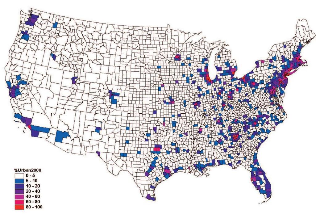
4 Image comes NOAA and was utilized by the NATIONAL BUREAU OF ECONOMIC RESEARCH within a July 2009 report called Measuring Economic Growth from Outer Space.

5
6 6
7 7
8 9


9

10 Strategy Where our solutions fit today Transform geospatial data into geospatial intelligence
11 Social harmony Connection to Cadastral Maps Green Infrastructure Power Infrastructure Economic growth Infrastructure
12 Cadastral Maps: Different challenges Developed World Developing World Long established cadastral mapping Poor or no cadastral maps Challenges Faster updates Save costs Standardization Challenges Establish a cadastral map and system Where to start? Extensive extra-legal infrastructure Integrating innovative approaches to accellerate the process


 in Lima Social")
13 Cadastral Maps The more people that are inside the legal system the better. Once you re in the legal system, you become more interested in the political system. - Hernando de Soto President, Institute for Liberty and Democracy (ILD) in Lima Social harmony Economi c growth Infrastructure
14 Cadastral Maps: Workflows Traditional Automation Centric 1. Aerial Survey - Images only 2. Data Processing 3. Visual comparison: images to cadastral map 4. Survey of changes 5. Map/GIS update 1. Aerial Surveyincl DSM/DTM 2. Data Processing 3. Automatic change detection: images + DSM /DTM to cadastre 4. Survey of Changes 5. Map/GIS update


15 GeoBasis-DE/LVermGeoRP Cadastral Change Detection Customer Rheinland-Pfalz, Germany Solution Automated detection of building changes in cadastral data Optional manual adjustment Visual QA/QC Results New Buildings Changed Buildings Non Mapping-relevant GeoBasis-DE/LVermGeoRP

16
17 Cadastral Change Detection ecognition and Inpho software allows us to automate time-consuming image processing workflows. Furthermore change detection of cadastral buildings (land survey register) with ecognition can be standardized and the effort for visual image interpretation and field comparison can be reduced.
 Ascertain tree canopy size and break it down")

18 Urban Tree Canopy Assessment: USFS / UVM Combine satellite images with aerial photos and tax maps (also LiDAR) Ascertain tree canopy size and break it down by parcel, determining which trees are on public land and which are on private land Current tree canopy and tree canopy potential Applied for a number of US cities

19 Social harmony Economi c growth Infrastructure "It really kicked off everything it helped us set our sights on 1 million trees" The environmental benefits and property value benefits are quantifiable, but the social ones are harder. "Tree canopies can make neighborhoods more cohesive and bring people together, bonding them over this common resource - Fiona Watt, chief of forestry and horticulture, New York Department of Parks and Recreation.
20 Power Lines &Vegetation: Blom Mapping trees and shrubs near power lines Vegetation in the height classes (e.g. 2.5 m)


21 Power Lines All images provided with permission by Blom ASA
22 Power Lines + Buffer All images provided with permission by Blom ASA
23 Vegetation > 2.5 meter All images provided with permission by Blom ASA
24 Vegetation > 2.5 meter All images provided with permission by Blom ASA
25 Conclusions Growth patterns will demand better solutions to the inherently spatial challenges of infrastructure management Automation is a natural path to standardizing traditional processes, bringing field work into the office, making those processes faster and more cost effective As vendors, our challenge is to commercialize geospatial technology, thereby collaboratively realizing tangible contributions to our global economic and societal well-being
26 Thank you Social harmony Economic growth Infrastructure Todd Douglas Taylor Trimble, GeoSpatial Division 27
Updated - A Report on the County of Arlington s Existing and Possible Urban Tree Canopy
 Updated - A Report on the County of Arlington s Existing and Possible Urban Tree Canopy Key Terms UTC: Urban tree canopy (UTC) is the layer of leaves, branches, and stems of trees that cover the ground
Fit-for Purpose Approaches to Land Administration
 Fit-for Purpose Approaches to Land Administration Brent Jones, PE, PLS Global Manager, Casastre/Land Records bjones@esri.com Land Administration GIS is the platform for land administration Land administration
Trimble Land Solutions -Transforming the way land
 Sanjeev Trehan Regional Manager - SAARC MARCH 2016 Trimble Land Solutions -Transforming the way land tenure is secured and land assets are managed. Government Opportunity Challenge Implementation of secure
The Journey to 100% Electronic Survey. Land Information New Zealand. August 2009
 The Journey to 100% Electronic Survey and Title Lodgement Land Information New Zealand August 2009 Land Information New Zealand Established 1996 Titles, Survey, Geodetic, Electoral 12 locations 500 staff
International funding projects in Republic Geodetic Authority
 International funding projects in Republic Geodetic Authority Serbia: Republic Geodetic Authority Workshop Exploring Funding Instruments for NMCA 7-8 November 2012 Republic Geodetic Authority Republic
Challenges for the multi purpose cadastre
 Jens RIECKEN, Markus SEIFERT, Germany Key words: Multi purpose cadastre, 3d-cadastre, land use, SDI, solar cadastre SUMMARY Over the past 30 years, with the progress of information technologies the development
Meeting the Changing National Geospatial Information Needs. Palitha Udayakantha Surveyor General - Sri Lanka
 Meeting the Changing National Geospatial Information Needs Palitha Udayakantha Surveyor General - Sri Lanka Sri Lanka Location Latitude 5 55 10-9 50 6 North Longitude 79 31 19-81 52 36 East Area 65610
The Survey Data Model Technology A practical survey solution to generate all levels of spatial and e-governance outcomes.
 Land Governance in a Rapidly Changing Environment Annual World Bank Conference on Land and Poverty April 24 & 25, 2012 The Survey Data Model Technology A practical survey solution to generate all levels
Institutional Arrangements In Geoinformation: Influence of Legal and Policy Issues **
 ADVANCE UNEDITED VERSION UNITED NATIONS E/CONF.103/24 ECONOMIC AND SOCIAL COUNCIL Tenth United Nations Regional Cartographic Conference for the Americas New York, 19-23, August 2013 Item 6 (a) of the provisional
TSO1C: Land Reforms. Commission 7
 TSO1C: Land Reforms. Commission 7 Development of & Implementation LIS. Building an effective Partnership to Reform Uganda s Land Administration (7320) Gasant Jacobs, Head: Business Development. Tax & Accounting
Challenges and Opportunities in Developing Innovative Geospatial Tools for Fit-For-Purpose Land Rights Mapping
 Challenges and Opportunities in Developing Innovative Geospatial Tools for Fit-For-Purpose Land Rights Mapping This project has received funding from the European Union's Horizon 2020 research and innovation
Land Administration Infrastructures for Sustainable Development
 The Global Challenges Land Administration Infrastructures for Sustainable Development Prof. Stig Enemark Department of Development and Planning Aalborg, University, Denmark INTERNATIONAL CONFERENCE ON
Esri Middle East and Africa User Conference. December Abu Dhabi, UAE. Land Administration. Mark Baker
 Esri Middle East and Africa User Conference December 10 12 Abu Dhabi, UAE Land Administration Mark Baker Our Agenda 0900 0930 Welcome Mark Baker, Esri 0930 1030 New Directions The New Addressing System
Reforming the Land Sector in Jamaica
 Silburn CLARKE and Llewelyn ALLEN, Jamaica Key words: tenure, cadastre, land reform, adjudication, public awareness, land titling, GPS, parcel mapping, traversing, land legislation, tenure regularisation,
e-cadastre and Photo-Interpretation Technologies
 UNECE- WPLA EFFICIENT AND TRANSPARENT LAND MANAGEMENT IN ECE COUNTRIES 4 March 2010 - Baku, Azerbaijan e-cadastre and Photo-Interpretation Technologies The Italian experience as an example of Good Practice
UNECE Working Party on Land Administration UNECE WPLA. Report on the work of the Bureau of the Working Party
 UNECE Working Party on Land Administration UNECE WPLA Report on the work of the Bureau of the Working Party 10 th Session of UNECE WPLA Geneva, 8 9 March 2017 UNECE Working Party on Land Administration
Jack McKenna, Director of Business Development, Africa and the Caribbean
 Presented at the FIG Working Week 2016, May 2-6, 2016 in Christchurch, New Zealand Jack McKenna, Director of Business Development, Africa and the Caribbean FIG WORKING WEEK 2016 Fit for Purpose Parcel
Digitalisation of the Real Property Rights Towards Spatially enabled E-Government
 Digitalisation of the Real Property Rights Towards Spatially enabled E-Government Lise Schroeder, Bent Hulegaard Jensen, Esben Munk Soerensen & Line Hvingel Istanbul, Turkey 25 june 201 Overview Introduction
Italian Cadastre and Real Estate Rights and Mortgages Registration System
 CLGE General Assembly Italian Cadastre and Real Estate Rights and Mortgages Registration System Franco Maggio Central Director Cartography, Cadastre and Real Estate Rights and Mortgages Registration System
Bureau of Land Management
 Bureau of Land Management MAPPS Federal Update Donald Buhler Cadastral, Lands, and Realty Management April 1, 2014 Division of Cadastral, Lands and Realty Management 1 BLM Mission Manages 247 million surface
PROCESSES IN CADASTRE: PROCESS MODEL FOR SERBIAN 3D CADASTRE
 UNIVERSITY IN NOVI SAD, SERBIA FACULTY OF TECHNICAL SCIENCES PROCESSES IN CADASTRE: PROCESS MODEL FOR SERBIAN 3D CADASTRE Dubravka SLADIĆ, Aleksandra RADULOVIĆ and Miro GOVEDARICA 6th International FIG
Organizational Project Management
 Organizational Project Management March 19, 2019 Lotfy Saleh: PMP, PgMP, PfMP, OPM3-CP, PMI-SP, PMI-RMP, PMI-ACP, PMI-PBA, CAPM TERMINOLOGIES Project Management Program Management Portfolio Management
Scenic Nepal. Land Administration Systems. Outline of Presentation. Interests in land. Rights: Registration and security of tenure positions
 Scenic Nepal Land Administration Systems Managing Rights, Restrictions, and Responsibilities in Land Prof. Stig Enemark President Aalborg University, Denmark SURVEY DEPARTMENT KATHMANDU, NEPAL. 16 FEBRUARY
Challenges in technology, society and policy - how they influence Cadastre and Land Management
 Challenges in technology, society and policy - how they influence Cadastre and Land Management Gyula IVÁN, Hungary Key words: Cadastre, Land Administration, GIS SUMMARY During the last years there has
Creating holistic architecture requires a sense of perspective
 Creating holistic architecture requires a sense of perspective BESSARDs Studio takes pride in being a small studio, since it allows them to control the entire architectural process. BIM generates a crucial
D DAVID PUBLISHING. Mass Valuation and the Implementation Necessity of GIS (Geographic Information System) in Albania
 in Albania") Journal of Civil Engineering and Architecture 9 (2015) 1506-1512 doi: 10.17265/1934-7359/2015.12.012 D DAVID PUBLISHING Mass Valuation and the Implementation Necessity of GIS (Geographic Elfrida Shehu
Journal of Civil Engineering and Architecture 9 (2015) 1506-1512 doi: 10.17265/1934-7359/2015.12.012 D DAVID PUBLISHING Mass Valuation and the Implementation Necessity of GIS (Geographic Elfrida Shehu
A beautiful setting. The Evolving Role of Cadastral Systems in Support of Good Land Governance. Setting the scene
 The Evolving Role of Cadastral Systems in Support of Good Land Governance Prof. Stig Enemark President Aalborg University, Denmark THE DIGITAL CADASTRAL MAP FIG COMMISSION 7 OPEN SYMPOSIUM KARLOVY VARY,
The Added Value of Geospatial Information in Disaster and Risk Management: A Case Study on the 2009 Flooding in Namibia
 The Added Value of Geospatial Information in Disaster and Risk Management: A Case Study on the 2009 Flooding in Namibia Summary Tessa Anne Belinfante, M.Sc. VU University Amsterdam Objective and Approach
The Multipurpose Marine Cadastre A Tool for Planning & Decision Making in the Marine Environment
 The Multipurpose Marine Cadastre A Tool for Planning & Decision Making in the Marine Environment Christine Taylor Minerals Management Service (MMS) Brian Smith NOAA Coastal Services Center Maurice Hill
PANAFRICA GEOINFORMATION SERVICES PLC ETHIOPIA
 PANAFRICA GEOINFORMATION SERVICES PLC ETHIOPIA Tenets PanafricaGIS is a technology-enthusiast company operated by experienced professionals in the field of geo-information. We believe a sustained and inclusive
A Geocoded Cadastral Fabric as a Precondition for a Sustainable Land Management System
 A Geocoded Fabric as a Precondition for a Sustainable Land Management System Gottfried KONECNY, Germany; J.P. LAUZON, Canada; Abdul Salam MOHAMMED, India Key words: SDI,, Parcel Boundaries, GPS-GNSS, Land
Building cities. Vernon Henderson, Tanner Regan and Tony Venables January 24, 2016
 Building cities Vernon Henderson, Tanner Regan and Tony Venables January 24, 2016 Motivation Buildings and land are typically about 60% of private wealth in nations. Growing cities require new housing
NEW TECHNOLOGIES & THEIR REAL ESTATE IMPACTS Dutch Treat Breakfast Meeting February 12, 2018 Taylor Mammen, Managing Director
 NEW TECHNOLOGIES & THEIR REAL ESTATE IMPACTS 2018 Dutch Treat Breakfast Meeting February 12, 2018 Taylor Mammen, Managing Director ABOUT RCLCO Since 1967, RCLCO has been the first call for real estate
2013 Project Abstract For the Period Ending June 30, 2015
 2013 Project Abstract For the Period Ending June 30, 2015 PROJECT TITLE: Conservation Easement Stewardship Program, Phase III PROJECT MANAGER: Don Kilberg AFFILIATION: Minnesota Department of Natural Resources
Information Quality - A Critical Success Factor How to make it all right!
 Information Quality - A Critical Success Factor How to make it all right! Anders Svensson, Sweden Key words: Cadastre, information quality, property information, property boundaries SUMMARY Sweden has
COMPUTERIZED SYSTEM SUPPORTING DEVELOPMENT OF LAND MARKET IN GEORGIA
 COMPUTERIZED SYSTEM SUPPORTING DEVELOPMENT OF LAND MARKET IN GEORGIA S. G. TSIRAMUA, I. S. MELASHVILI Land Registration Unit of Government of Georgian, World Bank and IFAD Agriculture Development Project.
By: Barney I. S. Laseko Programme Coordinator Prime Minister s Office TANZANIA
 2014 CONFERENCE ON LAND POLICY IN AFRICA 11 14 NOVEMBER, 2014 Focussed Discussion VIII Converting from Manual Land Registration to GIS Enabled Land Information System Case of Sub Saharan Africa Tanzania
New Technology for Cadastral Systems. Brent Jones, PE, PLS
 New Technology for Cadastral Systems Brent Jones, PE, PLS Benefits of Good Land Administration Key to addressing global challenges.. Secure Tenure Equitable Land and Property Taxation Support for Government
Complete BIM residential project
 Complete BIM residential project SARCO Architects Costa Rica Project name: Casa Magayon Type: Residential Location: Guanacaste, Costa Rica Year: 2015 Size: 13,900 ft 2 / 1290 m 2 Software used: GRAPHISOFT
IT-SUPPORTED STATE-LAND MANAGEMENT IN A TRANSITIONAL ENVIRONMENT
 IT-SUPPORTED STATE-LAND MANAGEMENT IN A TRANSITIONAL ENVIRONMENT - Examples from Eastern Germany and Mongolia - TOPICS 1 S LAND INFORMATION SYSTEM History and main components IT-strategy and development
Fiscal Cadastral Reform and the Implementation of CAMA in Cape Town: financing transformation
 Fiscal Cadastral Reform and the Implementation of CAMA in Cape Town: financing transformation Jennifer WHITTAL, South Africa Mike BARRY, Canada Policies and Innovations Expert Group Meeting on Secure Land
LADM-based Crowdsourced 3D Cadastral Surveying Potential and Perspectives
 National Technical University Of Athens School of Rural and Surveying Engineering LADM-based Crowdsourced 3D Cadastral Surveying Potential and Perspectives Maria Gkeli, Surveying Engineer, PhD student
Interoperability in surveying
 Interoperability in surveying Ron Bloksma Kadaster Dutch Land Registry Thread in my career Law Organisation Processes Information Legal interoperability Organisational interoperability Semantic interoperability
AUTOMATION PLATFORMS AND PROCESS MINING: A POWERFUL COMBINATION
 AUTOMATION PLATFORMS AND PROCESS MINING: A POWERFUL COMBINATION Summary When you need to replace a legacy system by a modern IT system, then process mining can help you to capture the full process with
The programme is implemented
 Surveying Property valuation and spatial data tools to assist in land restitution by Jaco de Kock, GISCOE Land and tenure reform in the South African government context are beyond talk and have received
Commission 7, Land Administration and IT. Paul van der Molen INTERNATIONAL INSTITUTE FOR GEO-INFORMATION SCIENCE AND EARTH OBSERVATION
 Commission 7, Land Administration and IT Paul van der Molen INTERNATIONAL INSTITUTE FOR GEO-INFORMATION SCIENCE AND EARTH OBSERVATION FIG Commission 7 on cadastre and land management Study Visits (e.g.
Egyptian Nationwide Title Cadastre System
 Kholoud SAAD, Egypt Key words: Cadastre, Registration, Urban, Rural, National Cadastre, Automation, reengineering. SUMMARY With growing need for integrated information, Enterprise Solutions has become
Low cost cadastral updating approach: an alternative for the Brazilian cities
 FIG WORKING WEEK 008 Integrating Generations Low cost cadastral updating approach: an alternative for the Brazilian cities Guilherme Henrique Barros de Souza Amilton Amorim Julio Kiyoshi Hasegawa Introduction
Land Markets and Land Rights in support of the Millennium Development Goals
 Land Markets and Land Rights in support of the Millennium Development Goals A Global Perspective Prof. Stig Enemark President Aalborg University, Denmark 3rd LAND ADMINISTRATION FORUM FOR THE ASIA AND
Functional system for cadastral plans
 , Republic of Macedonia Key words: Cadastre, Digital plans, Data, System SUMMARY The analysis shows that the real estate market in Republic of Macedonia grows daily. With the expansion of this market increases
OGC Land Administration Domain Working Group
 Land Administration Domain Working Group Denise McKenzie Open Geospatial Consortium dmckenzie@opengeospatial.org Functions of a Domain Working Group Provide a forum for discussion Develop Change Requests
Shaping the Cadastral Infrastructure for a Digital Future
 DEPARTMENT OF LANDS PLANNING and the ENVIRONMENT Shaping the Cadastral Infrastructure for a Digital Future Craig Sandy Director Surveys Surveyor General Survey Branch NT Australia Digital Cadastral Databases
1-2 November 2018, Amsterdam Theme: Enabling Tomorrow s Connected Infrastructure #GEODESIGNBIM. www. geo-bim.org
 1-2 November 2018, Amsterdam Theme: Enabling Tomorrow s Connected Infrastructure #GEODESIGNBIM Report www. geo-bim.org Overview The second edition of GEO Design+BIM, the one of its kind event focusing
Conservancy Mission. Leveraging GIS Technologies in Chesapeake Conservation and Restoration 10/17/2018
 Leveraging GIS Technologies in Chesapeake Conservation and Restoration Rachel Soobitsky Geospatial Project Manager Chesapeake Conservancy Conservation Innovation Center Kristin Kirkwood Executive Director
Modernizing Land Administration Systems
 Presented at the FIG Congress 2018, May 6-11, 2018 in Istanbul, Turkey Modernizing Land Administration Systems B r e n t J o n e s P E, PLS E s r i Land Administration Systems GIS is the Technology Platform
Directorate of Survey and Mapping NAMIBIA. Cadastral Information System. Vehupisa Kasuko Tjatindi Surveyor Directorate of Survey and Mapping NAMIBIA
 Vehupisa Kasuko Tjatindi Directorate of Survey and Mapping NAMIBIA Tel: +64 61 965000 Directorate of Survey and Mapping NAMIBIA Cadastral Information System Introduction Over the past few decades cadastral
Implementing Innovative Land Tenure Tools In East-Africa: SWOT-Analysis Of Land Governance
 Presented at the FIG Working Week 2017, May 29 - June 2, 2017 in Helsinki, Finland Implementing Innovative Land Tenure Tools In East-Africa: SWOT-Analysis Of Land Governance Ine BUNTINX, Joep CROMPVOETS,
EXPLORING OPTIONS FOR STANDARDISATION OF PROCESSES AND TRANSACTIONS IN LAND ADMINISTRATION
 EXPLORING OPTIONS FOR STANDARDISATION OF PROCESSES AND TRANSACTIONS IN LAND ADMINISTRATION CHRISTIAAN LEMMEN (1),(2), EVA-MARIA UNGER (2), PETER VAN OOSTEROM (3), MOHSEN KALANTARI (4) AND KEES DE ZEEUW
Housing the World: London, Toronto, and Amsterdam. Isabel Monteleone Research Analyst, Bay Area Council Economic Institute
 Housing the World: London, Toronto, and Amsterdam Isabel Monteleone Research Analyst, Bay Area Council Economic Institute January 2019 The Bay Area is a global economic success model. If it were a country,
researchproject M.Sc. Pauliina Krigsholm, National Land Survey of Finland PCC conference, November 2017
 Cadastre2035 researchproject M.Sc. Pauliina Krigsholm, National Land Survey of Finland PCC conference, November 2017 Theaspectsof theresearch Megatrends Users and stakeholders Global themes Future cadastral
Good Land Governance for the 2030 Agenda
 Good Land Governance for the 2030 Agenda Addis Ababa, Ethiopia 20-22 April, 2014 Role of Geospatial Information in Good Land Policy and Governance Oumar Sylla UN-Habitat/GLTN oumar.sylla@unhabitat.org
Land and the New Urban Agenda EGM June 2016
 EGM June 2016 Filiep Decorte Deputy Director New York Liaison Office UN-Habitat 2 August 2016 ROLE OF LAND IN URBAN DEVELOPMENT The New Urban Agenda is about people People need a place to live. Place means
G. Schennach / Chair Commission 7. Common Vision Conference 5-6 Oct 2017, Vienna, Austria
 Cadastre 4.0 - Integrating the community for global security on land tenure Gerda Schennach, Austria Chair of FIG Commission 7 1 200 years of innovation Fiscal Legal Local Digital Taxation Land Tenure
THE 2030 AGENDA, CITIES AND URBAN GOVERNANCE A CENTRAL ROLE FOR LAND AND GEOSPATIAL INFORMATION
 THE 2030 AGENDA, CITIES AND URBAN GOVERNANCE A CENTRAL ROLE FOR LAND AND GEOSPATIAL INFORMATION Abbas Rajabifard Immediate Past President and Executive Board Member, GSDI Association Director, Centre for
Alternatives for Economic Boundary Determination in the Establishment of a Cadastral System. Paper to the FIG Working Week 2012 Rome, May 9, 2012
 Alternatives for Economic Boundary Determination in the Establishment of a Cadastral System Paper to the FIG Working Week 2012 Rome, May 9, 2012 by Gottfried Konecny Emeritus Professor Leibniz University
Learning from land suitability analysis and Dutch spatial policy for sustainable land use in Japan
 Learning from land suitability analysis and Dutch spatial policy for sustainable land use in Japan Toru Nagayama 22 January 2009 GIS Research Group Seminar, University of Tsukuba Highlights from : Nagayama.,
Use of data in Ukraine for sustainable economic growth. Oleksandr Maliuk State Service of Ukraine for Geodesy, Cartography and Cadastre
 Use of data in Ukraine for sustainable economic growth Oleksandr Maliuk State Service of Ukraine for Geodesy, Cartography and Cadastre Kehl, 2017 Content of the presentation Ukraine & StateGeoCadastre:
PROJECT INFORMATION DOCUMENT (PID) CONCEPT STAGE Report No.: AB3229 Project Name. Land Registry and Cadastre Modernization Project Region
 CONCEPT STAGE Report No.: AB3229 Project Name. Land Registry and Cadastre Modernization Project Region") PROJECT INFORMATION DOCUMENT (PID) CONCEPT STAGE Report No.: AB3229 Project Name Land Registry and Cadastre Modernization Project Region EUROPE AND CENTRAL ASIA Sector Central government administration
PROJECT INFORMATION DOCUMENT (PID) CONCEPT STAGE Report No.: AB3229 Project Name Land Registry and Cadastre Modernization Project Region EUROPE AND CENTRAL ASIA Sector Central government administration
ParcelMap BC. Compiling a Parcel Fabric for the Province of British Columbia. WENDY AMY and ELLEN STYNER
 ParcelMap BC Compiling a Parcel Fabric for the Province of British Columbia WENDY AMY and ELLEN STYNER Who is MNC? Established in 1997, MNC is a geomatics engineering firm located in Calgary, Alberta.
Securing Land Rights for Broadband Land Acquisition for Utilities in Sweden
 Securing Land Rights for Broadband Land Acquisition for Utilities in Sweden Marija JURIC and Kristin LAND, Sweden Key words: broadband, land acquisition, cadastral procedure, Sweden SUMMARY The European
Technology-driven solutions for the innovation of land administration and management
 Technology-driven solutions for the innovation of land administration and management Technology and economic growth - Studies*find link between technology innovation and national economic prosperity especially,
THE NEED FOR APPROACHES AND TECHNOLOGY OF TOMORROW
 THE NEED FOR APPROACHES AND TECHNOLOGY OF TOMORROW KEES DE ZEEUW, CHRISTIAAN LEMMEN and BERNY KERSTEN Cadastre, Land Registry and Mapping Agency - Kadaster, The Netherlands Kees.dezeeuw@kadaster.nl Paper
Cadastre in Addis Ababa. Status and future development
 Status and future development Dr.-Ing. Paul Hartfiel Mülheim, 1. Oct. 2010-1 - Addis Ababa Capital of Ethiopia Area population 540 km² > 3,200,000 (rapidly growing) 2,300,000 in 1994 > 22% of all urban
Behavioral Impact of the Financing Collection Mechanism on Accessibility:! Two Cases from Chinese Cities
 Behavioral Impact of the Financing Collection Mechanism on Accessibility:! Two Cases from Chinese Cities David Block-Schachter Based on research w Jinhua Zhao & Drewry Wang October 22, 2013 Plan A dialogue:
Flexible tenure. 1 Global Innovation assessment - Human Cities Coalition
 Flexible tenure Decision making process: Explore to develop new mechanisms to better integrate community needs into existing city development/housing plans, in particular plans around development of new
The New Technology of a Survey Data Model and Cadastral Fabric as the Foundation for a Future Land Administration System.
 The New Technology of a Survey Data Model and Cadastral Fabric as the Foundation for a Future Land Ian HARPER, Australia Key words: cadastral modelling, survey data model, Survey Accuracy, Cadastre 2014
Presented by: Stewart Information International, Inc. Jack McKenna
 Presented by: Stewart Information International, Inc. Jack McKenna Held at the: 2007 ESRI Survey & Engineering GIS Summit San Diego Convention Center San Diego, California June 16-19, 2007 Integrating
Advances in Modern Land Administration Cadastre 2014 in the Year 2006
 Advances in Modern Land Administration Cadastre 2014 in the Year 2006 Winfried HAWERK, Germany Key words: E-Land Administration, IT renewal strategies SUMMARY FIG Commission 7 Working Group 7.3 deals with
Open Title: a Low Cost Tool for Inventorying Property Rights - Experiences from Ghana
 Open Title: a Low Cost Tool for Inventorying Property Rights - Experiences from Ghana Nigel EDMEAD, USA Key words: Open Title, Paralegal Title, Ghana, ESRI SUMMARY As part of an ongoing program to formalize
GLOBAL GEOSPATIAL MANAGEMENT INFORMATION
 GLOBAL GEOSPATIAL MANAGEMENT INFORMATION SEOUL, KOREA 24 th to 26 th October 2011 COUNTRY REPORT - REPUBLIC OF BOTSWANA 1. INTRODUCTION 1.1. SOCIAL, ECONOMIC AND POLITICAL BACKGROUND Botswana attained
OPEN BIM Healthcare Design by LINK arkitektur
 OPEN BIM Healthcare Design by LINK arkitektur LEARN HOW BIM helps clients to understand and follow the design process; Main image place an information database connected to BIM elements makes the requirement
Germany on the way to a 4D-Cadastre
 Germany on the way to a 4D-Cadastre Dr. Jens Riecken (DVW Vicepresident), Ulrich Gruber, Dr. Markus Seifert (DVW WG Geoinformation) TS 9.1 4D Cadastre, Land Domain Models & Concepts 1 Content About my
Land Administration Developments in Rwanda
 Land Administration Developments in Rwanda Eugène RURANGWA Expert Group Meeting on secure land tenure new legal frameworks and tools UN-Gigiri, Nairobi, 10-12 November, 2004 Contents Somme figures about
Establishing Efficient Cadastral Surveying Plan in Accordance with Introducing World Geodetic Reference System in Korea
 Modern Environmental Science and Engineering (ISSN 2333-2581) December 2015, Volume 1, No. 6, pp. 299-303 Doi: 10.15341/mese(2333-2581)/06.01.2015/003 Academic Star Publishing Company, 2015 www.academicstar.us
Land Information System as new instrument for Land Administration: Case Examples. Mike Cheremshynskyi Consultant, Land Administration Expert
 Land Information System as new instrument for Land Administration: Case Examples Mike Cheremshynskyi Consultant, Land Administration Expert Background Growth of population and fast urbanization in many
Using BIM for interior design
 Using BIM for interior design Ikeda Architecture www.ikeda-architecture.jp Established in : 2010 Representative: Yoichiro Ikeda Speciality: Shop design interior Head Office: Yokohama, Japan Software: ARCHICAD,
GIS Projects and Systematic Land Registration in Romania Brasov Case Study
 GIS Projects and Systematic Land Registration in Romania Brasov Case Study Ionut SAVOIU, Ciprian SAVOIU, Mircea POPA and Georgeta CHITAC, Romania Key words: cadastre, land registration, land book SUMMARY
aurelis Real Estate GmbH & Co. KG
 www.aurelis-real-estate.com aurelis Real Estate GmbH & Co. KG IBB GIS the information platform for real-estate related data AED-SYNERGIS has implemented a pilot project for the Region South of the real-estate
Developing Infrastructure Framework To Facilitate The Malaysia Multipurpose 3D Cadastre
 Developing Infrastructure Framework To Facilitate The Malaysia Multipurpose 3D Cadastre Sr Dr. Tan Liat Choon Sr Looi Kam Seng University of Technology Malaysia Department of Survey and mapping Malaysia
Content. Development and Potential for Improvements of the Austrian Land Administration System. Introduction. Dynamic Framework of Land Administration
 Development and Potential for Improvements of the Austrian Land Administration System Reinfried MANSBERGER, BOKU Vienna Gerhard MUGGENHUBER, BEV Vienna Gerhard NAVRATIL, TU Vienna Christoph TWAROCH, TU
EQUIPMENT LEASING SOLUTIONS FOR PROCUREMENT
 EQUIPMENT LEASING SOLUTIONS FOR PROCUREMENT DEFINE YOUR STRATEGY Computers Trucks Automobiles Network & Data Center Research & Lab Equipment Forklifts Machinery Who is Managing Your Leasing Spend? Most
ParcelMap BC Compiling a Parcel Fabric for the Province of British Columbia. Presented by: Ellen Styner (General Manager) and Wendy Amy (GIS Manager)
 and Wendy Amy (GIS Manager)") ParcelMap BC Compiling a Parcel Fabric for the Province of British Columbia Presented by: Ellen Styner (General Manager) and Wendy Amy (GIS Manager) Who is MNC? MNC is a geomatics engineering firm with
ParcelMap BC Compiling a Parcel Fabric for the Province of British Columbia Presented by: Ellen Styner (General Manager) and Wendy Amy (GIS Manager) Who is MNC? MNC is a geomatics engineering firm with
Smart Infrastructure Benefits and Key Players from a Global Perspective
 Smart Infrastructure Benefits and Key Players from a Global Perspective Spatial@gov 2010 October 5-7 Canberra Jude Wallace and Abbas Rajabifard Centre for Spatial Data Infrastructures and Land Administration
STREAMLINING LAND ADMINISTRATION AND GOVERNANCE IN CROSS RIVER STATE, NIGERIA by Engr. Bassey Oqua, Chiemeka Ngwu, Nigel Edmead & Frank Pichel
 STREAMLINING LAND ADMINISTRATION AND GOVERNANCE IN CROSS RIVER STATE, NIGERIA by Engr. Bassey Oqua, Chiemeka Ngwu, Nigel Edmead & Frank Pichel FIG Working Week, Abuja, May 6 th 10 th 2013 Environment for
ASPECTS OF A 3D CADASTRE IN THE NEW CITY OF MODI IN, ISRAEL
 ASPECTS OF A 3D CADASTRE IN THE NEW CITY OF MODI IN, ISRAEL ARMI GRINSTEIN Armi Grinstein - Geodetic Engineering Ltd. Israel ABSTRACT 3 Dimensional Cadastre is a relatively new sphere in property registration,
INTRODUCTION. Regulation of GI as stated in the Law of Indonesia No. 4 of 2011 about
 FRANKO JHONER, SH As Speaker at Geospatial World Forum 2014, Legal Drafter at The Indonesian Geospatial Information Agency (Badan Informasi Geospasial, Republik Indonesia) Geneva - Switzerland TITLE: PERMISSION
INDIAN INSTITUTE OF TECHNOLOGY ROORKEE. Presentation on REAL TIME CADASTRAL SURVEYING SOLUTION WITH A SPECIAL IMPHESIS TO MODERN GPS TECHNOLOGY.
 INDIAN INSTITUTE OF TECHNOLOGY ROORKEE Presentation on REAL TIME CADASTRAL SURVEYING SOLUTION WITH A SPECIAL IMPHESIS TO MODERN GPS TECHNOLOGY By: Prof. Kamal Jain, Dept. of Civil Engg. IIT-Roorkee AIM
A Vision for a Fully Digital Cadastral Survey System
 A Vision for a Fully Digital Cadastral Survey System Anselm HAANEN, Trent GULLIVER, New Zealand Key words: cadastral survey system, digital cadastre, survey plans SUMMARY Surveyors have traditionally prepared
Background. Contents. Analyses of current LA. Data workflow within LA. Strategy for an integrated LAS. Conclusion
 2007. 5. 21 Contents Background Analyses of current LA Data workflow within LA Strategy for an integrated LAS Conclusion Background LA data is a main sector for successful e-government Customer demands
Fit-For-Purpose Land Administration: Guiding Principles FACILITATED BY:
 Fit-For-Purpose Land Administration: Guiding Principles 1. GLTN overview - GLTN BRIEFING AND PROGRAMME 2. Geospatial Data - Sustainable Development - 3. Fit-for-purpose Land Administration Guiding Principles