ParcelMap BC Compiling a Parcel Fabric for the Province of British Columbia. Presented by: Ellen Styner (General Manager) and Wendy Amy (GIS Manager)
|
|
|
- Vanessa Annabel Hill
- 5 years ago
- Views:
Transcription


1 ParcelMap BC Compiling a Parcel Fabric for the Province of British Columbia Presented by: Ellen Styner (General Manager) and Wendy Amy (GIS Manager)
2 Who is MNC? MNC is a geomatics engineering firm with a qualified team of surveyors, geomatics engineers, survey technicians and GIS specialists Established 20 years ago in Calgary Alberta Experts in Surface Land Mapping (Cadastral, Parcel, Disposition) Esri users since 2002 Esri Silver Partner
 across multiple formats (CAD/GIS) and platforms; especially for")
 and Cadastral (250K Plans) since 1998 - Alberta Disposition Mapping since 2005 (½ million parcels) 2M Parcels Compilation 2017 1.")
3 Who is MNC? MNC specializes in working with very large datasets (city/county/province-wide) across multiple formats (CAD/GIS) and platforms; especially for municipal or government clients - Alberta Title parcels (1.9 million) and Cadastral (250K Plans) since Alberta Disposition Mapping since 2005 (½ million parcels) 2M Parcels Compilation M Parcels MNC has been maintaining since M Parcels Compilation Property Parcel Fabric for Manitoba Hydro in Esri s Parcel Fabric (1.5 million parcels) - ParcelMap BC build completed in 2017 (2 million parcels)

4 The Land Title and Survey Authority of British Columbia (LTSA) Responsible for land titles and survey systems in British Columbia (BC) Stakeholders had a longstanding need for an easy, efficient means of accessing land title and survey information Intuitive map-based access

5 Strategic Objectives ParcelMap BC (PMBC) Primary goal for the ParcelMap BC (PMBC) project is to create and develop an operational model for a single, complete, trusted and sustainable visual representation of lands within a given parcel and its relationship to adjacent parcels. Single Complete Trusted Sustainable Includes parcel fabrics for all local government areas including municipalities, the rural areas of all Regional Districts, and all surveyed parcels of provincial Crown lands. Includes all active parcels in the provincial Crown Land Registry and all parcels with active titles in the LTSA s Land Title Register. The parcel fabric will adhere to standards for parcel attribution, topology, currency, auditability and spatial accuracy. New surveys are to adhere to spatial accuracy standards, and as a result, the quality of the entire parcel fabric will improve over time. PMBC parcel fabric and operational framework is financially sustainable and will be maintained and enhanced over time by LTSA with guidance from our stakeholders.
6 MNC Scope for PMBC Three Elements #1 CADASTRAL TIE COLLECTION To support accuracy assessments and on-going spatial improvements #2 PARCEL FABRIC Single, complete, trusted and sustainable (conversion and compilation) #3 SURVEY PLAN SUBMISSIONS Web based digital plan submission and checking system
7 Field Tie Collection To support accuracy assessments and on-going spatial improvements

8 Field CAD Tie Collection Process Challenge: Collecting, checking and managing the survey data (spatial and metadata) in an affordable way ArcGIS Online; CAD tie planning and workflow management Configured ArcGIS Collector; field tie collection

9 ArcGIS Online Planning Field Ties

10 CATS Cadastral Tie Survey Application
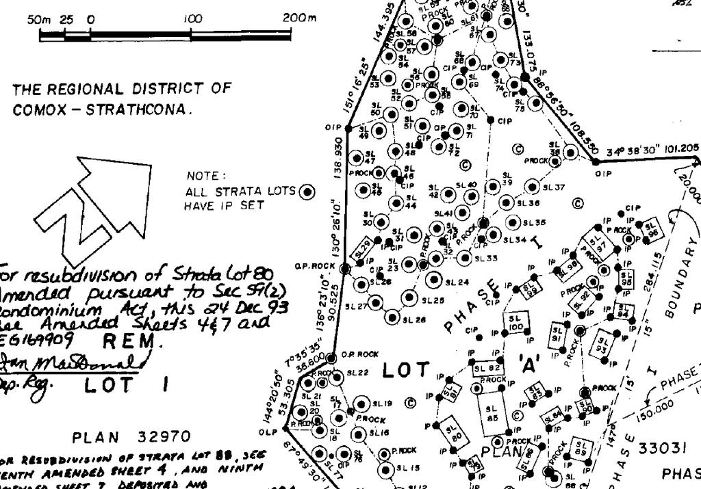
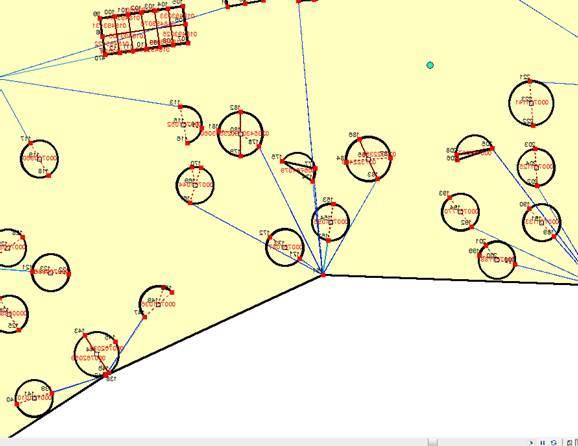
11 Plan Image Red Lines

12 Field Tie Image

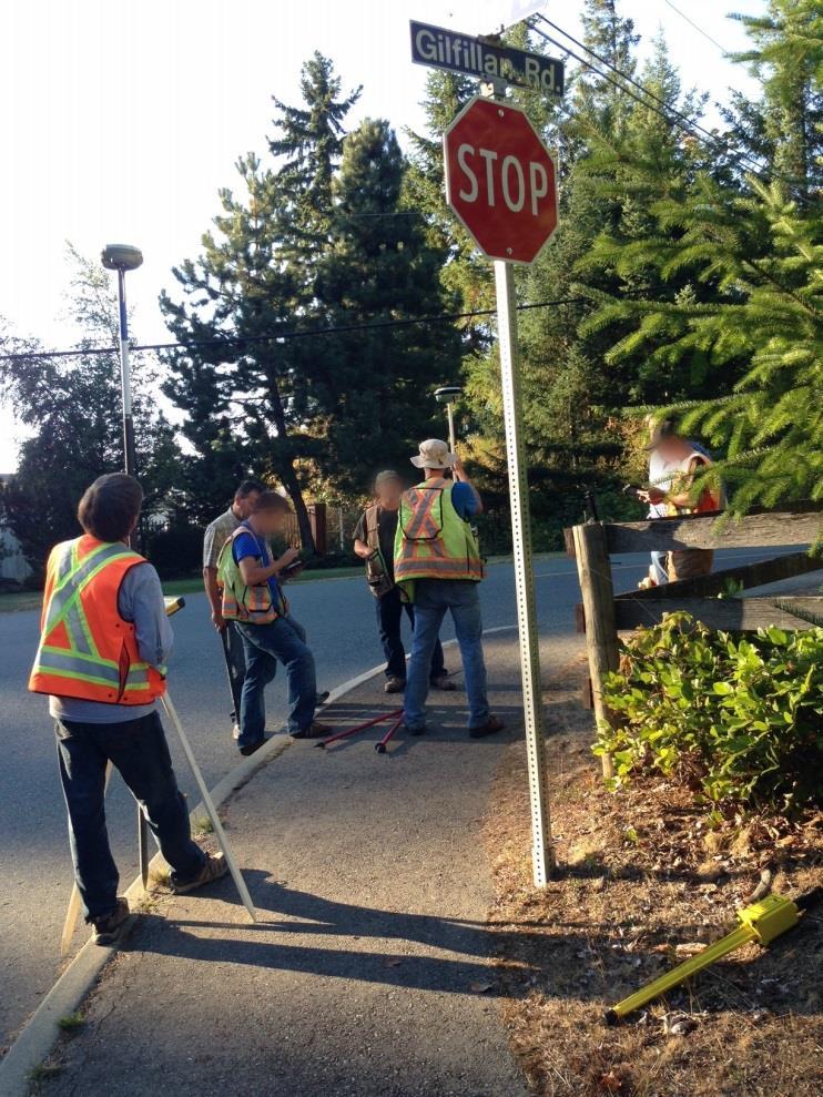
13 Field Crew Training
14 Tie Collection from Survey Plans To support accuracy assessments and on-going spatial improvements
15

16 Identifying Features and Filling Out the Form Mascot
17 Red Lining the Survey Plan
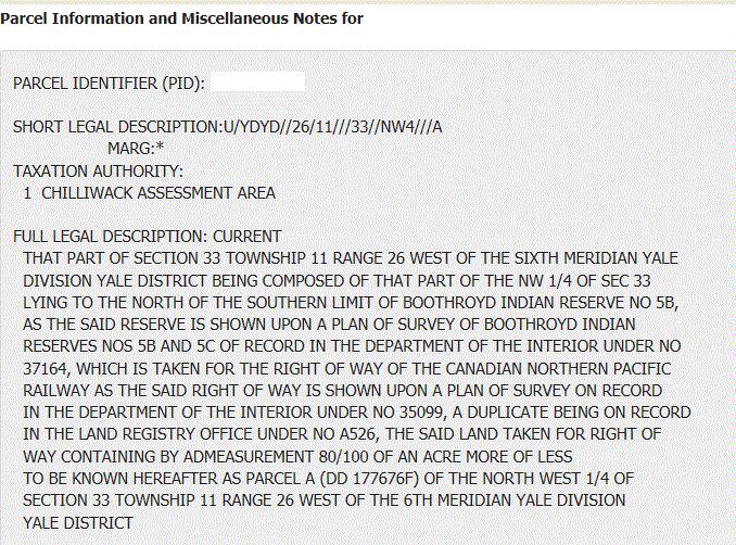
18 Metadata Collection Metadata collected from the survey plan: Survey Method UTM Zone Datum Elevation Type Elevation Combined Scale Factor (CSF) CSF Source Positional Accuracy Degrees, Minutes and Seconds (to Mascot) Distance (to Mascot) Other fields are automatically collected: Control ID (automatically assigned) LTSA Plan Mascot is selected from the map: - Mascot # - GCM - Northing and Easting
19 #2 Parcel Fabric Single, complete, trusted and sustainable (conversion and compilation)


20 Parcel Fabric Delivery Plan
21 Esri s Parcel Fabric Esri s parcel fabric was selected as the preferred data model and maintenance tool set for LTSA operations team because: 1. Commercial off-the-shelf (COTS) solution 2. Proven solution implemented in various other large jurisdictions similar to BC (2 million parcels) 3. Least Squares Adjustments (LSA) engine to improve the fabric s spatial accuracy
22 Elements of a Parcel Esri s Parcel Fabric The best parcel fabric is one built from survey plans, whereby all observations (distances and bearings) are captured and retained. Plans 1 1-M Parcels 1-M 1 1 Points M Lines 0-1 Control 1-1 Line Points 0-M

23 Precision Input Example
24 Interesting Data Conditions

 Line Must be Single")
 Parcel Fabric Load topology to a parcel fabric (Create point features and COGO attributes) QA staging Attribute")
25 Generate Fabric-Ready Geometry CPDM Input polygons (ICF) Fix overlaps, gaps Feature to 2- point line Fix dangles, undershoots, duplicates Create true circular arcs Input polygons Crown Subdivision & Remainders, Local Government As-is Cadastral Feature to centroid points Re-Build polygons Line Must be Covered by Boundary Of (polygon) Line Must Not Self-Overlap Line Must Not Self-Intersect Join point attributes onto polygons Connection lines Staging lines fabric attributes creation (Type, Accuracy, Planname, Category) Line Must be Single Part Line Must Not Intersect or Touch Interior Staging polygons fabric attributes creation (Type, Accuracy, Planname) Polygon Boundary Must be Covered by (Line) Parcel Fabric Load topology to a parcel fabric (Create point features and COGO attributes) QA staging Attribute validation Topology Validation
26 Lessons Learned Clean data in staging features as simple feature classes Research to resolve poor geometry (gaps, overlaps) Generating curves from short segments is tricky - Modifying script parameters to work both on large-radius roads and cul-de-sacs while not inadvertently creating curves on natural boundaries LSA considerations such as connectivity and control were impacted by fabric that was not created from scratch (survey plans) One parcel can be defined by the remainder of many plans; one missing parcel does not necessarily mean one plan to draw

27
28 Acceptance Process A test plan organized the testing and acceptance process Total of 54 tests to ensure completeness and correctness Comprehensive increment and/or province-wide Random samples for visual inspection Lesson Learned Review MNC Acceptance Client (LTSA) Testing Release Factory Testing
29 #3 Survey Plan Submissions Web based digital plan submission and checking system
30 Survey Plan Submissions (SPS) To support sustainability, BC Land Surveyors are required to submit their survey plan datasets to LTSA as part of the mandatory process for plan package submissions Surveyors submit their datasets through Survey Plan Submissions (SPS); an innovative web map application that runs custom geoprocessing services to perform various business rule checks that validate their digital survey plan quality online #3 SURVEY PLAN SUBMISSIONS: Built a web based application called Survey Plan Submission (SPS) to support BC s operational maintenance.

 2016")
 2013 Reduced Effort More Secure More")
31 Plan Submission & Online Checking The Benefits Reduced Errors & Costs Improved Quality User Friendly British Columbia Alberta Saskatchewan Visual Check for Users Faster Approvals Survey Plan Submission (SPS) 2016 Survey Plan Online Checker (SPOC) 2010 Plan Submission Online (PSO) 2013 Reduced Effort More Secure More Information and Detail
32 Create a New Dataset To submit their survey plan datasets in SPS, surveyors must first create a new dataset Enter in metadata (E.g., Survey Date, UTM Zone, etc.) Upload the survey data CAD file (in DWG format) Upload the control point CSV file Save changes to move onto the next step

33 Validate the Dataset A number of business rules are checked to validate the integrity of data provided and report any errors

34 Parcel Topology Check Result


35 Perform a Map Check Surveyors perform a visual check to ensure the plan is correctly positioned within the PMBC fabric

36 Submit the Dataset


37 Input Fabric Compilation Output Land Title Register (Parcel Attribute Data) ICIS Source Parcels ICF Source Parcels 2 Million 1.7 Million 1.5 Million Extract, Transform and Load Cadastral Ties 65,400 Crown Primaries 76,000 Crown Subdivisions 173,000 Crown Transportation 107,000 Crown Undersurface 16,000 Crown SRW 31,000 Indian Reserves 1,450 Assessment Areas 19 Conservancy Areas 157 Federal Harbor & Port Authority 19 Integrated Survey Areas 53 Land Districts 7 Land Title Districts 61 Municipalities 160 National Parks 7 Parks and Protected Areas 924 Regional Districts 29 Survey Plans 200,000 Create New Data Cadastral Field Ties 2,600 Cadastral Ties from Plans 4,500 Catch-up Plans 2,500 Attribute Enhancements 55,000 Precision Input of Missing Parcels 10,000 From Disparate Source Data to a Single, Complete, Trusted and Sustainable Parcel Fabric 2 Million Parcels Completed in 2½ Years
38 Inc. 1 Inc. 2 Inc. 3 Inc. 5/6 Inc. 7/9 Inc. 11/12 Inc. 4/8 Inc. 10/13 Inc. 14/15 Inc. A Inc. B Inc. C Project Start Project Completed Project Status Jul 2014 Aug 2014 Sep 2014 Oct 2014 Nov 2014 Dec 2014 Jan 2015 Feb 2015 Mar 2015 Apr 2015 May 2015 Jun 2015 Jul 2015 Field Tie Program PWL (Province Wide Layers) FCP (Fabric Compilation Plan) Acceptance Test Plan Ties from Survey Plans Aug 2015 Sep 2015 Oct 2015 Nov 2015 Dec 2015 Jan 2016 Feb 2016 Mar 2016 Apr 2016 May 2016 Jun 2016 Jul 2016 Aug 2016 Sep 2016 Oct 2016 Nov 2016 Dec 2016 Jan 2017 Feb 2017 Mar 2017 Apr 2017 May 2017 Jun 2017 Fabric Increments Accepted SPS Application Mandatory for Surveyors Largest Parcel Fabric Implementation in Canada


39 Thank you! If you have any questions or would like more information please contact: or MNC (Martin Newby Consulting Ltd.)
ParcelMap BC. Compiling a Parcel Fabric for the Province of British Columbia. WENDY AMY and ELLEN STYNER
 ParcelMap BC Compiling a Parcel Fabric for the Province of British Columbia WENDY AMY and ELLEN STYNER Who is MNC? Established in 1997, MNC is a geomatics engineering firm located in Calgary, Alberta.
Overview 7/6/2016. Agenda. Introduction to ParcelMap BC LGMA Annual Conference Nanaimo, BC. ParcelMap BC Primary Goal
 Agenda Overview ParcelMap BC Primary Goal ParcelMap BC Key Benefits ParcelMap BC Advisory Committee BC Assessment Grant Program Introduction to ParcelMap BC LGMA Annual Conference Nanaimo, BC Mike Thomson
Spatial Data Warehouse Ltd. Cadastral Mapping INITIATIVE 1: CADASTRAL MAPPING. Version Spatial Data Warehouse Ltd. & AltaLIS Ltd.
 Spatial Data Warehouse Ltd. Initiative 1: Cadastral Mapping INITIATIVE 1: CADASTRAL MAPPING 29 P3 The SDW/AltaLIS Model Background The Government of Alberta started a mapping program, the Municipal Integrated
City of Surrey s Digital Plan Submission Process
 City of Surrey s Digital Plan Submission Process Cadastral Update Karen Stewart, B.Tech. (GIS) Spatial Information Manager Peter Mueller, B.C.L.S., C.L.S. Survey Manager City of Surrey, British Columbia,
PREPARING SURVEY TENDER GIS DATABASE OUTCOMES
 PREPARING SURVEY TENDER SPECIFICATIONS FOR PROJECT GIS DATABASE OUTCOMES Presentation by Ian Harper GEODATA AUSTRALIA ESRI User Conference 2009 24 st July 2009 BACKGROUND GIS databases now provide a more
Cadastral Framework Standards
 Cadastral Framework Standards The goal of the Data Standards and Recommendations Committee is to provide recommendations and guidelines to Indiana GIS user communities to facilitate the collection, maintenance
First Nations Land Registry
 First Nations Land Registry Making Sense of the ILRS Steven Patterson, Sitka Geomatics Inc. www.sitkageo.com Land Titles a brief history Land titles were traditionally managed within the community, and
The New Technology of a Survey Data Model and Cadastral Fabric as the Foundation for a Future Land Administration System.
 The New Technology of a Survey Data Model and Cadastral Fabric as the Foundation for a Future Land Ian HARPER, Australia Key words: cadastral modelling, survey data model, Survey Accuracy, Cadastre 2014
The Cadastral Modelling Future and The Land Surveyors Role
 The Cadastral Modelling Future and The Land Surveyors Role Ian Harper Geodata Australia ESRI Survey Summit July 2013 The Land Surveyors Future Role From Custodians of the Cadastre to Custodians of the
Using GIS To Manage Surface Ownership and Right-Of-Way
 Using GIS To Manage Surface Ownership and Right-Of-Way Jeff Bute - Sr. Land Maintenance Rep. / GIS Analyst Jeff was formerly a Property Tax Right of Way and Claims field agent for the company. Now he uses
GOVERNMENT. Case Study Ville de Trois Rivières streamlines property assessment
 GOVERNMENT Case Study Ville de Trois Rivières streamlines property assessment GIS-generated parcel basemap provides powerful visualization & analysis capabilities With a population of just over 130,000,
General Instructions For Surveys and Plans Outside the Provincial Survey System
 May 15, 2018 General Instructions For Surveys and Plans Outside the Provincial Survey System NOTE: This document is a Controller of Surveys Policy manual to be used as a general guideline for the Legal
1. INTRODUCTION PURPOSE APPLICABILITY... 3
 STANDARD OPERATING PROCEDURE CADASTRAL BASE MAPPING SECTION BASE MAPPING AND GEOMATICS SERVICES BRANCH, MINISTRY OF SUSTAINABLE RESOURCES MANAGEMENT TABLE OF CONTENTS 1. INTRODUCTION... 3 2. PURPOSE...
Hybrid Cadastre Pilot Project Guidelines for Public Land Disposition Surveys Operations Division
 Hybrid Cadastre Pilot Project Guidelines Operations Division January 12, 2015 Version Update Version No. Date Summary of Changes 2.0 January 12, Table of Contents 2015 Table of Contents added to Guidelines.
A Vision for a Fully Digital Cadastral Survey System
 A Vision for a Fully Digital Cadastral Survey System Anselm HAANEN, Trent GULLIVER, New Zealand Key words: cadastral survey system, digital cadastre, survey plans SUMMARY Surveyors have traditionally prepared
Installation Boundary Mapping and the DoD Real Property Inventory Program
 Installation Boundary Mapping and the DoD Real Property Inventory Program 11 October 2007 SAME Mid-Atlantic Regional Conference Jeff Swallow Real Property History Real Property data reported to the Office
FGDC SUBCOMMITTEE FOR CADASTRAL DATA. October 2004 Albuquerque, New Mexico Meeting
 FGDC SUBCOMMITTEE FOR CADASTRAL DATA October 2004 Albuquerque, New Mexico Meeting The National Spatial Data Infrastructure is the means to assemble geographic information that describes the arrangements
Online Cadastre and Tantalis GATOR
 Online Cadastre and Tantalis GATOR Online Cadastre Free, public online access to BC Crown land cadastral information and other geographic data LTSA is responsible for maintenance of and enhancements to
A CADASTRAL GEODATA BASE FOR LAND ADMINISTRATION USING ARCGIS CADASTRAL FABRIC MODEL A CASE STUDY OF UWANI ENUGU, ENUGU STATE, NIGERIA
 A CADASTRAL GEODATA BASE FOR LAND ADMINISTRATION USING ARCGIS CADASTRAL FABRIC MODEL A CASE STUDY OF UWANI ENUGU, ENUGU STATE, NIGERIA BY Ndukwu, Raphael. Ike Department of Geoinformatics & Surveying University
An Overview of the eplan Journey with a Focus on the Victorian eplan 2025 Roadmap Dr Hamed Olfat
 An Overview of the eplan Journey with a Focus on the n eplan 2025 Roadmap Dr Hamed Olfat eplan Coordinator Land Use Chairman of Technical Committee ICSM eplan Working Group Outline eplan Overview ICSM
Presented by: Stewart Information International, Inc. Jack McKenna
 Presented by: Stewart Information International, Inc. Jack McKenna Held at the: 2007 ESRI Survey & Engineering GIS Summit San Diego Convention Center San Diego, California June 16-19, 2007 Integrating
1 June FNB House Price Index - Real and Nominal Growth MAY FNB HOUSE PRICE INDEX FINDINGS
 1 June 2016 MARKET ANALYTICS AND SCENARIO FORECASTING UNIT JOHN LOOS: HOUSEHOLD AND PROPERTY SECTOR STRATEGIST 087-328 0151 john.loos@fnb.co.za THEO SWANEPOEL: PROPERTY MARKET ANALYST 087-328 0157 tswanepoel@fnb.co.za
Real Estate Administration at the Vancouver Port Authority (VPA) Presentation by Ron McMillan - GIS/LIS Coordinator December 13, 2004
 Presentation by Ron McMillan - GIS/LIS Coordinator December 13, 2004") Real Estate Administration at the Vancouver Port Authority (VPA) Presentation by Ron McMillan - GIS/LIS Coordinator December 13, 2004 Introduction Overview of the Vancouver Port Authority (VPA) How CAD
Real Estate Administration at the Vancouver Port Authority (VPA) Presentation by Ron McMillan - GIS/LIS Coordinator December 13, 2004 Introduction Overview of the Vancouver Port Authority (VPA) How CAD
Certified Crisis Management Professional. Contents are subject to change. For the latest updates visit
 Certified Crisis Management Page 1 of 8 Why Attend This course provides participants with concrete crisis management solutions and strategies, while giving insight into the delivery of effective Crisis
Egyptian Nationwide Title Cadastre System
 Kholoud SAAD, Egypt Key words: Cadastre, Registration, Urban, Rural, National Cadastre, Automation, reengineering. SUMMARY With growing need for integrated information, Enterprise Solutions has become
Introduction to MPAC & Farm Assessment
 Introduction to MPAC & Farm Assessment Delivering the 2016 Assessment Update Cramahe Township Ontario Agri-Food Venture Centre Terri-lyn Wright, Property Valuation Specialist Catherine Barr, Account Manager
Landbase Accuracy with Cadastral Editor
 Landbase Accuracy with Cadastral Editor City Makes Enhancements for Improved Planning By Kristy M. Capobianco, GISP, RS&H Donald Terrell, GISP, City of Jacksonville Beach and William C. Mann, AICP, City
LADM-based Crowdsourced 3D Cadastral Surveying Potential and Perspectives
 National Technical University Of Athens School of Rural and Surveying Engineering LADM-based Crowdsourced 3D Cadastral Surveying Potential and Perspectives Maria Gkeli, Surveying Engineer, PhD student
Ontario West Municipal Conference Assessment Update Retrospective and A Look Ahead
 Ontario West Municipal Conference 2016 Assessment Update Retrospective and A Look Ahead City of London December 2, 2016 Carla Nell, Vice-President Municipal and Stakeholder Relations ONTARIO S ASSESSMENT
TOWARDS E-LAND ADMINISTRATION - ELECTRONIC PLANS OF SUBDIVISIONS IN VICTORIA
 TOWARDS E-LAND ADMINISTRATION - ELECTRONIC PLANS OF SUBDIVISIONS IN VICTORIA Mohsen Kalantari 1, Chris Lester 2, David R Boyle 3, Neil Coupar 4 1 eplan Coordinator 2 SPEAR Manager 3 Deputy Surveyor General
Cloud GIS Real Estate Management, Appraisal and Development Service USING ESRIs ARCGIS SERVER
 Cloud GIS Real Estate Management, Appraisal and Development Service USING ESRIs ARCGIS SERVER INFODIM: Was founded on 1992 and is internationally certified as a GIS company from D&B Dun & Bradstreet Global
Modernizing Land Administration Systems
 Presented at the FIG Congress 2018, May 6-11, 2018 in Istanbul, Turkey Modernizing Land Administration Systems B r e n t J o n e s P E, PLS E s r i Land Administration Systems GIS is the Technology Platform
Flood Hazard Modelling
 Flood Hazard Modelling Identification Information Dataset Name: Rapid Flood Hazard Model, Detailed Flood Hazard Model Dataset Abstract: The flood hazard model identifies areas that may be subject to flooding
What s Next for Commercial Real Estate Leveraging Technology and Local Analytics to Grow Your Commercial Real Estate Business
 What s Next for Commercial Real Estate Leveraging Technology and Local Analytics to Grow Your Commercial Real Estate Business - A PUBLICATION OF GROWTH MAPS- TABLE OF CONTENTS Intro 1 2 What Does Local
Land Administration and Spatial Enablement Victoria s Experience. Chris McRae, Executive Director Land Victoria
 Land Administration and Spatial Enablement Victoria s Experience Chris McRae, Executive Director Land Victoria 4 th UN Land Administration Forum, October 2011 Outline About Land Victoria Land Victoria
Innovations in Education at Faculty ITC and within Land Administration Programme
 Innovations in Education at Faculty ITC and within Land Administration Programme Prof. Jaap Zevenbergen, Vice-Dean Education at Faculty ITC, Prof. Land Administration dr. Dimo Todorovski, Course Coordinator
Amalia Velasco Carlos Alonso Luis Virgos Fernando Serrano
 Inspire services of the Spanish Directorate General for Cadastre and its use to resolve an old problem of coordination between Spanish Cadastre and Land Registry. Amalia Velasco Carlos Alonso Luis Virgos
Mineral Administration Registry Saskatchewan System. Regulatory Overview
 Mineral Administration Registry Saskatchewan System Regulatory Overview Prepared for: Law Society of Saskatchewan Focus On: Corporate Commercial Law Seminar Prepared by: Doug MacKnight Executive Director,
CATALOGING, MONITORING AND MANAGING INVASIVE SPECIES ON POST LANDS. PSU Geog596A Capstone Proposal Dale Jantzen Dec 17, 2015
 CATALOGING, MONITORING AND MANAGING INVASIVE SPECIES ON POST LANDS PSU Geog596A Capstone Proposal Dale Jantzen Dec 17, 2015 PROJECT OUTLINE AND PURPOSE Define a particular need within a non-profit land
Cadastral Survey Data Exchange Format - LandXML
 Cadastral Survey Data Exchange Format - LandXML Version v 2.0 Customer Systems Customer Services National Office Land Information New Zealand rivate Box 5501 Wellington Email: info@linz.govt.nz March 2010
State of Washington Project Luke Rogers, University of Washington March 2010
 State of Washington Project Luke Rogers, University of Washington March 2010 Rural Technology Initiative (RTI) developed an online tutorial on how to use the Washington State Parcel and Forestland Databases
A Geocoded Cadastral Fabric as a Precondition for a Sustainable Land Management System
 A Geocoded Fabric as a Precondition for a Sustainable Land Management System Gottfried KONECNY, Germany; J.P. LAUZON, Canada; Abdul Salam MOHAMMED, India Key words: SDI,, Parcel Boundaries, GPS-GNSS, Land
MLS of Greater Cincinnati - Charts for the Month: November 2017
 MLS of Greater Cincinnati - Charts for the Month: November 2017 The following charts provide an overview of what has occurred in the MLS over the past month. Each chart provides a historical trend. The
MonthlyStatistics APRIL 2018
 MonthlyStatistics APRIL 2018 FOR IMMEDIATE RELEASE May 1, 2018 Sales Holding Steady Amid Rising House Prices NANAIMO, BC Sales of single-family homes in the VIREB area rose by 20 per cent month over month
Bureau of Business Research Webinar Series October 2016
 Bureau of Business Research Webinar Series October 2016 Presented by Eric Thompson W.W. Marshall Associate Professor of Economics Director, Bureau of Business Research Outline Importance of Affordable
Certified Internal Auditor Exam Preparation. Contents are subject to change. For the latest updates visit
 Certified Internal Auditor Exam Preparation Page 1 of 11 Why Attend This preparatory course is designed to equip candidates with the knowledge and skills required to write and pass the Certified Internal
Using ArcGIS Server for National Property Information System
 Using ArcGIS Server for National Property Information System Shota Chachkhunashvili (National Agency of Public Registry, Georgia) Mikheil Tsiklauri (Geographic, Georgia) San Diego, 2008 About us National
Implementation Status & Results Macedonia, former Yugoslav Republic of Real Estate Cadastre & Registration Project (P083126)
") Public Disclosure Authorized Public Disclosure Authorized Implementation Status & Results Macedonia, former Yugoslav Republic of Real Estate Cadastre & Registration Project (P083126) Operation Name: Real
Public Disclosure Authorized Public Disclosure Authorized Implementation Status & Results Macedonia, former Yugoslav Republic of Real Estate Cadastre & Registration Project (P083126) Operation Name: Real
A Review and Perspective on Parcel Data Models for Urban Planning
 A Review and Perspective on Parcel Data Models for Urban Planning Yiqiang Ouyang Prof. Dr. Ilir Bejleri Department of Urban and Regional Planning University of Florida June 19-21, 2010 1 Content 1. Introduction
Parcel Identifiers for Cadastral Core Data: Concepts and Issues
 Parcel Identifiers for Cadastral Core Data: Concepts and Issues Nancy von Meyer, Bob Ader, Zsolt Nagy, David Stage, Bill Ferguson, Katie Benson, Bob Johnson, Stu Kirkpatrick, Robert Stevens, Dan Mates
The University of Massachusetts Campus Master Plan. Faculty Senate April 21st
 The University of Massachusetts Campus Master Plan Faculty Senate April 21st Update on process and schedule 2011 Summer 2012 Oct Nov Dec Jan Feb Mar Apr May Jun Jul Aug Sep Oct Nov Dec Jan Feb Mar Apr
Queens Rental Market Report February 2018 mns.com
 Queens Rental Market Report February 2018 TABLE OF CONTENTS 03 Introduction 04 A Quick Look 10 Queens Price Trends 11 Neighborhood Price Trends 11 Long Island City 12 Astoria 13 Ridgewood 14 Flushing 15
MonthlyStatistics AUGUST 2017
 MonthlyStatistics AUGUST 2017 FOR IMMEDIATE RELEASE September 1, 2017 VIREB Housing Market Continues to Sizzle NANAIMO, BC The Vancouver Island Real Estate Board (VIREB) reports that single-family home
Automated Land Development Applications
 Automated Land Development Applications AGENDA Yarra Valley Water Land Development Process GIS Automation Business Rules Engine Automated Spatial Analysis Questions.Encourage GIS community to embrace GIS
Cadastral NSDI Reference Document
 Cadastral NSDI Reference Document Version 12 October 2012 FGDC Subcommittee for Cadastral Data Cadastral NSDI Reference Document Table of Contents 1. Purpose... 1 2. Business Applications... 1 3. Terminology
NEW HOMES REGISTRY REPORT
 December 218 British Columbia s Monthly NEW HOMES REGISTRY REPORT Leading Housing Market Indicator for B.C. Registered new homes data are a leading indicator of housing and economic 1 activity in British
MonthlyStatistics MARCH 2018
 MonthlyStatistics MARCH 2018 FOR IMMEDIATE RELEASE April 3, 2018 Sales Down From 2017 But Prices Still Rising Due to Limited Inventory NANAIMO, BC Sales of single-family homes, apartments, and townhouses
MonthlyStatistics FEBRUARY 2018
 MonthlyStatistics FEBRUARY 2018 FOR IMMEDIATE RELEASE March 1, 2018 Buoyant Sellers Market Continues NANAIMO, BC Last month, 316 single-family homes sold on the Multiple Listing Service (MLS ) System compared
Fit-for Purpose Approaches to Land Administration
 Fit-for Purpose Approaches to Land Administration Brent Jones, PE, PLS Global Manager, Casastre/Land Records bjones@esri.com Land Administration GIS is the platform for land administration Land administration
Agenda Project Overview Project Objectives Registration Service Re-Engineering System Overview
 Agenda Project Overview Project Objectives Registration Service Re-Engineering System Overview Sydney, Australia, 11 16 April 2010 1 Project Overview Future Vision There is a vision within senior levels
Esri Middle East and Africa User Conference. December Abu Dhabi, UAE. Land Administration. Mark Baker
 Esri Middle East and Africa User Conference December 10 12 Abu Dhabi, UAE Land Administration Mark Baker Our Agenda 0900 0930 Welcome Mark Baker, Esri 0930 1030 New Directions The New Addressing System
Mineral Resources Authority (MRA) FlexiCadastre Papua New Guinea
 FlexiCadastre Papua New Guinea") Mineral Resources Authority (MRA) FlexiCadastre Papua New Guinea Louie Kawale Mining Management System Administrator Margaret Aulda Senior Technical Assessment Officer Nancy Wafiwa Assessment Geologist
Mineral Resources Authority (MRA) FlexiCadastre Papua New Guinea Louie Kawale Mining Management System Administrator Margaret Aulda Senior Technical Assessment Officer Nancy Wafiwa Assessment Geologist
Ownership Data in Cadastral Information System of Sofia (CIS Sofia) from the Available Cadastral Map
 from the Available Cadastral Map") Ownership Data in Cadastral Information System of Sofia (CIS Sofia) from the Available Cadastral Map Key words: ABSTRACT Lydmila LAZAROVA, Bulgaria CIS Sofia is created and maintained by GIS Sofia ltd,
Ownership Data in Cadastral Information System of Sofia (CIS Sofia) from the Available Cadastral Map Key words: ABSTRACT Lydmila LAZAROVA, Bulgaria CIS Sofia is created and maintained by GIS Sofia ltd,
Public Lands Formal Disposition Application Process
 April 19, 2018 List of Documents and Webpages To access the AEP documents referenced in this schedule, search one of the following document titles at aep.alberta.ca Associated Dispositions, Access Roads
The Challenge to Implement International Cadastral Models Case Finland 1
 The Challenge to Implement International Cadastral Models Case Finland 1 Tarja MYLLYMÄKI and Tarja PYKÄLÄ, Finland Key words: cadastre, modelling, LADM, INSPIRE SUMMARY Efforts are currently made to develop
Public Disclosure Copy
 Public Disclosure Authorized EUROPE AND CENTRAL ASIA Kosovo Social, Urban, Rural and Resilience Global Practice Global Practice IBRD/IDA Investment Project Financing FY 2010 Seq No: 19 ARCHIVED on 10-Jan-2018
Puerto Rico Housing Finance Authority Housing Stimulus Programs
 Puerto Rico Housing Finance Authority Housing Stimulus Programs March 31, 2012 (Final with US Data) Total sales assisted by PRHFA stimulus from $240MM Fund Assignment As of March 31, 2012 Silent Second
Cadastral PLSS Stewardship December 2010 Updated December 2013
 Cadastral PLSS Stewardship December 2010 Updated December 2013 Compiled by Bob Ader, Ben Knott, and Nancy von Meyer for the FGDC Cadastral Subcommittee Table of Contents 1. Overview... 2 2. Underlying
MonthlyStatistics MARCH 2017
 MonthlyStatistics MARCH 2017 FOR IMMEDIATE RELEASE April 3, 2017 Low Inventory Continues to Limit Vancouver Island Buyers NANAIMO, BC The Vancouver Island Real Estate Board (VIREB) reports that in March
Property Based Land Information Systems of Turkey
 Property Based Land Information Systems of Turkey Mehmet Fatih DİRİ, Bilgehan ÖZSOY, Ünsal ERGÜN, Turkey Key words: Cadaster, Land Registry, GIS, Property, TURKEY SUMMARY The property, addition to the
Modernizing the Land Titles System in Yukon. What We Heard Report
 What We Heard Report Yukon Department of Justice Fall, 2012 What We Heard Report Table of Contents What We Heard Report... 2 1. What We Heard about the Appropriate System for Recording Land Interests in
PLSS as a Spatial Framework: A History of GCDB Steven L. Hope. Abstract. Background
 PLSS as a Spatial Framework: A History of GCDB Steven L. Hope Abstract The Bureau of Land Management (BLM) initiated the Geographic Coordinate Data Base (GCDB) project to digitally portray the Public Land
Housing Bulletin Monthly Report
 February 21 1 Housing Bulletin Monthly Report Housing Starts 25, 2, 15, 1, 5, Alberta Housing Starts up 5 per cent from 29 From February 29 to 21, preliminary housing starts increased 82.7 per cent across
July 2012 was $162,256. ($153,956). was $314,607. was $172,488. ($164,426). Kansas City Region Average Sales Price - Existing Homes
. was $314,607. was $172,488. ($164,426). Kansas City Region Average Sales Price - Existing Homes") July 212 Kansas City Regional Real Estate Market Report Average Sales Price The average exis ng home sale price in July 212 was $162,256. 25 Kansas City Region Average Sales Price - Existing Homes July
July 212 Kansas City Regional Real Estate Market Report Average Sales Price The average exis ng home sale price in July 212 was $162,256. 25 Kansas City Region Average Sales Price - Existing Homes July
Housing Bulletin Monthly Report
 December 21 1 Housing Bulletin Monthly Report Alberta Housing Starts Fall in November 21 Canada Housing Starts 25 2 15 1 5 8 NOV 8 DEC 8 Preliminary Housing Starts in Alberta* and Canada* November 28 to
GIS and Land Records Integration A PRIA White Paper
 110 Horizon Drive, Suite 210, Raleigh, NC 27615 919.459.2081 GIS and Land Records Integration A PRIA White Paper Adopted by the PRIA Board on December 20, 2017 www.pria.us/ GIS and Land Records Integration
A Complete, Free Solution for Cadastral Map Management
 A Complete, Free Solution for Cadastral Map Management Gyula IVÁN Institute of Geodesy, Cartography & Remote Sensing (FÖMI) HUNGARY FIG Commission 7, Annual Meeting 11-15 September 2008., Verona, ITALY
Revenue. Major part of ULB's revenue comes by means of:
 Revenue Major part of ULB's revenue comes by means of: Collecting property tax Issuing trade licenses Alloting its land and buildings to carry out business Collecting usage charges and service fees for
Affiliate Appraiser Pak
 Affiliate Appraiser Pak Thank you for your interest in Affiliate Appraiser Membership with PAR. Attached are the required forms you will need to complete in order to join. It is your responsibility to
Meeting the Changing National Geospatial Information Needs. Palitha Udayakantha Surveyor General - Sri Lanka
 Meeting the Changing National Geospatial Information Needs Palitha Udayakantha Surveyor General - Sri Lanka Sri Lanka Location Latitude 5 55 10-9 50 6 North Longitude 79 31 19-81 52 36 East Area 65610
Guide to Zoning By-Laws in Manitoba Presentation to AMM Convention
 Guide to Zoning By-Laws in Manitoba Presentation to AMM Convention November 24, 2015 Project Team & Committee Project Team HTFC Planning & Design McCandless Tramley Fotenn Planning & Urban Design Steering
SFR Condo Residential Lot Sales Inventory Sales Inventory Sales Inventory. Month YTD Month Month YTD Month Month YTD Month
 Grand Strand Market Report 2017 capped off a great year for the Grand Strand as full year SFR sales volume and median sales price were up 9.8% and 4.3%, respectively. Condo sales activity increased 3.0%
Multi-Family Methodology Analysis
 Multi-Family Methodology 2018 Analysis Assessment Department February, 2018 2018 Multi-Family Assessment Methodology Property assessments in the City of Medicine Hat reflect the fee simple market value
Public Lands Formal Disposition Application Process
 February 16, 2018 List of Documents and Webpages To access the AEP documents referenced in this schedule, search one of the following document titles at aep.alberta.ca Associated Dispositions, Access Roads
NEW DEVELOPMENTS IN THE REAL PROPERTY REGISTER AND CADASTRE IN LITHUANIA
 NEW DEVELOPMENTS IN THE REAL PROPERTY REGISTER AND CADASTRE IN LITHUANIA Jaunius Grigas E-mail: jaunius.grigas@registrucentras.lt Verona, 2008 FUNCTIONS OF STATE ENTERPRISE CENTRE OF REGISTERS Registration
Housing Bulletin Monthly Report
 February 211 1 Housing Bulletin Monthly Report Alberta s preliminary housing starts declined in January 211 Canada Housing Starts 25, 2, 15, 1, 5, DEC 8 JAN 9 Preliminary Housing Starts in Alberta* and
Economic Spotlight September 1, 2009
 Economic Spotlight September 1, 29 Update on Alberta s Housing Market Summary Alberta s housing market is beginning to show signs of recovery. Housing starts have rebounded from March lows and activity
International Financial Reporting Standards (IFRS) and 2018 Updates
 and 2018 Updates") International Financial Reporting Standards (IFRS) and 2018 Updates Page 1 of 11 Why Attend Our 'International Financial Reporting Standards (IFRS) and 2018 Updates' course will help build the knowledge
International Financial Reporting Standards (IFRS) and 2018 Updates Page 1 of 11 Why Attend Our 'International Financial Reporting Standards (IFRS) and 2018 Updates' course will help build the knowledge
Theme Strategic Plan for Cadastral Theme
 Theme Strategic Plan for Cadastral Theme Bureau of Land Management Cadastral Survey Federal Geographic Data Committee (FGDC) 2017 2021 April 2017 - Progress and Update Cadastral Theme Implementation Plan
Competitive Strategies and Value Innovation. Contents are subject to change. For the latest updates visit
 Competitive Strategies and Value Innovation Page 1 of 9 Why Attend This course introduces key concepts, tools, and principles of strategic management allowing managers to create their organization's unique
LANDONLINE PRE-VALIDATION
 LANDONLINE PRE-VALIDATION ACCURACY RULE TESTS RUN DURING PRE-VALIDATION OF CADASTRAL SURVEY DATASETS Land Information New Zealand Customer Services May 2010 Version 4.0 Table of Contents Introduction...3
MonthlyStatistics JULY 2018
 MonthlyStatistics JULY 2018 FOR IMMEDIATE RELEASE August 1, 2018 Prices Continue to Sizzle in Summer Housing Market NANAIMO, BC Prices of single-family homes, apartments, and townhouses continue to rise
Integrating SAS and Geographic Information Systems for Regional Land Use Planning
 Integrating SAS and Geographic Information Systems for Regional Land Use Planning ABSTRACT Bill Bass, Houston-Galveston Area Council, Houston, Tx The Houston-Galveston Area Council (H-GAC) provides regional
THE VALUE PROPOSITION OF A STRONG INDUSTRY ASSOCIATION SCOTT ANDISON
 THE VALUE PROPOSITION OF A STRONG INDUSTRY ASSOCIATION SCOTT ANDISON JANUARY 15, 2016 THE LINE UP THE FRPO BRAND INDUSTRY PROFILE THE NEED FOR INDUSTRY ADVOCACY SELECT POLICY PRIORITIES QUESTIONS 2 Professional
Keywords: Land Information System, Land Administration, Cadastre, Land Parcel
 Corporate-LIS for Effective Land Administration of Sri Lanka Nelson Wijenayake Senior Superintendent of Surveys, Survey Department of Sri Lanka nelsonwijenayake@gmail.com Abstract A drastic improvement
Accounts Payable: Accounting and Management Best Practices
 Accounts Payable: Accounting and Best Practices Page 1 of 11 Why Attend Accounts Payable (AP) is not just processing checks, mailing them and then filing the backup paperwork. To truly and effectively
Cadastral Information System of Sofia
 Alexander LAZAROV and Hristo DECHEV, Bulgaria Key words: ABSTRACT A new Cadastre and Property Register Act (CPRA) was passed in April 2000, setting up rules for the maintenance of these two registers.
The World Bank Integrated Land Administration System Project (P122219)
") Public Disclosure Authorized EUROPE AND CENTRAL ASIA Croatia Social, Urban, Rural and Resilience Global Practice Global Practice IBRD/IDA Investment Project Financing FY 2012 Seq No: 14 ARCHIVED on 07-Dec-2017
Public Disclosure Authorized EUROPE AND CENTRAL ASIA Croatia Social, Urban, Rural and Resilience Global Practice Global Practice IBRD/IDA Investment Project Financing FY 2012 Seq No: 14 ARCHIVED on 07-Dec-2017
OPEN BIM Healthcare Design by LINK arkitektur
 OPEN BIM Healthcare Design by LINK arkitektur LEARN HOW BIM helps clients to understand and follow the design process; Main image place an information database connected to BIM elements makes the requirement
Released: April 8, 2011
 Released: April 8, 2011 Commentary 2 The Numbers That Drive Real Estate 3 Special Report 9 Brought to you by: KW Research Commentary The housing market continues on a relatively stable and balanced track.