THE 2030 AGENDA, CITIES AND URBAN GOVERNANCE A CENTRAL ROLE FOR LAND AND GEOSPATIAL INFORMATION
|
|
|
- Edgar Harrison
- 6 years ago
- Views:
Transcription


1 THE 2030 AGENDA, CITIES AND URBAN GOVERNANCE A CENTRAL ROLE FOR LAND AND GEOSPATIAL INFORMATION Abbas Rajabifard Immediate Past President and Executive Board Member, GSDI Association Director, Centre for SDIs and Land Administration Head, Department of Infrastructure Engineering, The University of Melbourne

2 GLOBAL AGENDA FOR SUSTAINABLE DEVELOPMENT MILLENNIUM DEVELOPMENT GOALS SUSTAINABLE DEVELOPMENT GOALS
3 THE 2030 AGENDA AND SDGS

4 THE 2030 AGENDA AND SDGS NEED DIRECT GOOD LINK LAND/SPATIAL TO RESOURCES INFORMATION
5 LAND, PEOPLE AND SUSTAINABILITY Climate Change RRRs Scarce Resources Population Increase Social Inclusion Ownerships Urban Sprawl Location links us to where we are and Land Sustainability what we are doing. People Wealth Creation Vertical Villages Degraded and Contaminated Land Health and Wellbeing

6 BY 2030 Make cities and human settlements inclusive, safe, resilient and sustainable. Indicators: Housing and basic services Transport systems and road safety Inclusive and sustainable urbanisation Protect and safeguard cultural and natural heritage Reduce impact of disasters; Hyogo framework Reduce environmental impact of cities Access to green and public spaces National and regional planning Sustainable and resilient buildings using local materials
7 BY % world s population will live in cities 600 Cities will play a key role in the success Dobbs et al., 2011; Bouton et al., 2013 of achieving SDGs cities will account for 60 % global GDP Habitat III

8 URBANISATION TREND WILL CONTINUE

9 COMPLEX STRUCTURES

10 COMPLEX URBAN INTERDEPENDENCIES 3D 4D 2D Need for multi-dimensional land/spatial information.


11 COMPLEX URBAN INTERDEPENDENCIES URBANISATION CITIES SENSOR NETWORKS Cadastre & SDI the backbone in efficient urban government and governance. TECHNOLOGICAL TRENDS
12 SMART CITY CONCEPT Urbanisation Globalisation Technology & Data Sustainability Economic competitiveness SMART CITY Use ICT to develop intellectual capital and participatory practices in the governance of a city s resources (Holland, 2008; Caragliu et al, 2011)

13


14 PLAN MELBOURNE (TO 2050) MELBOURNE WILL BE A GLOBAL CITY OF OPPORTUNITY AND CHOICE. House, employ and move more people around the metropolitan area, and beyond. Build confidence, investment and employment Become a global city of opportunity and choice.

15 LIMITATIONS DRIVERS OF 2D INFORMATION 3D planning development Need for integrated information. management community knowledge

16 NEW TECHNOLOGICAL OPPORTUNITIES BIM Digital data 3D trends
17 SPATIAL PLANNING TOOLS & OPEN DATA There are two major improvements on application of spatial planning tools. 1. Current generation of spatial data infrastructure allow the geospatial information partnering across stakeholders and different jurisdictions, called open data infrastructure. 2. The advantages of migrating from 2D to third and fourth dimensional SDI in planning and decision making tasks.
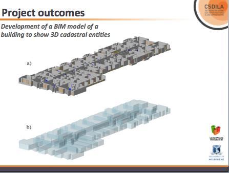
18 3D MODELS AND SPATIAL PLANNING Current 3D Models and technologies: 3D City Models such as City Geography Markup Language (CityGML) Building Information Models (BIM) 3D Cadastre Added more value to sustainable information sharing and semantic for representing volumetric urban objects, such as buildings, vegetation objects, waterbodies, and other urban infrastructures.


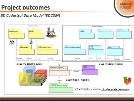
19 3D CADASTRE DATA MODEL (3DCDM) Paper based Representation of Ownership Boundaries Digital Representation of Ownership Boundaries and Physical objects, including BIM 3D Cadastral Data Model Data Model (3DCDM) Legislation Institution Technology Includes: Legal objects Physical objects Legal objects (eg. ownership boundary, easement..) Physical objects (eg. Wall, floor...)


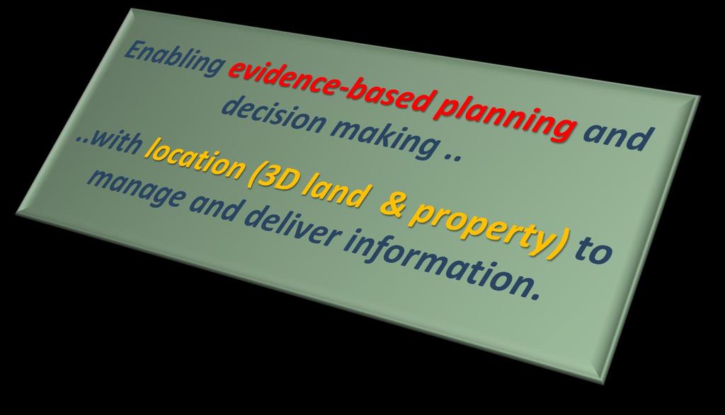
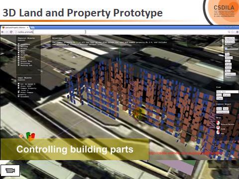
20 (MUTOPIA 2013) 3D LAND & PROPERTY INFORMATION Building From an individual property and building level to a city level This requires a spatially accurate map-base and cadastre as a foundation. Precinct City
21 SPATIALLY ENABLED SOCIETY SUPPORTING SMART FUTURE CITIES SDI 3D Cadastre SES Big/ Open Data
22 ROADMAP AND POTENTIAL STRATEGIES
23 PROJECT FOCUS INSTITUTIONAL CHALLENGES Regulatory Social Cultural Social Core Technical Core 3D Land and Property TECHNICAL CHALLENGES Data source Data model Data visualisation BIM
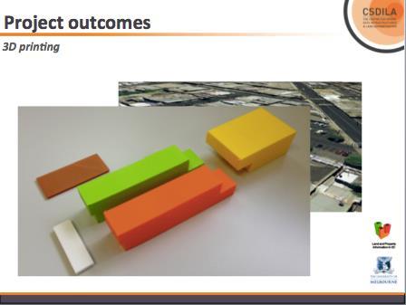
24 PROJECT OUTCOMES STRATEGY DEVELOPMENT Cultural change Collaboration Adoption Implementation Social Core Technical Core 3D Land and Property 4 prototypes 2 data models 26 publications 10 new expert resources into the market TECHNICAL TOOLS Data model Web-based visualisation platform Specifications


25 PROJECT OUTCOMES

26 FRAMEWORK FOR CHANGE: 2D TO 3D Digital economy Urbanisation 3D tech/info (Other drivers) SOCIETAL DEMANDS AND EXPECTATIONS First principle: CULTIVATE LEGITIMACY (3D as necessary) Align with macro-level societal demands and expectations to cultivate legitimacy around 3Denabled land administration as appropriate foster legitimacy focus legitimacy Maintain short/longer-term relevance and appropriateness of strategies/actions Fourth principle: PERIODIC REVIEW INSTITUTIONAL PRESSURE Second principle: STRATEGIC LEADERSHIP Focus broader legitimacy through strategic leadership. Develop strategies to operationalise 3Denabled land administration (CONFORMITY) 3D-ENABLED URBAN LAND ADMINISTRATION Third principle: SUPPORT CHANGE AND ACTION Support cultural change: normalisaton and internalisation of new 3Denabled practices and processes (3D as industry norm) (Serene Ho 2014)


27 Industry Government FUTURE CADASTRES : NEW CONNECTIONS Aus Cadastre 2034 States Community Location/ Spatial Strategies Private sector DB apps 3D Data Collaborate. Leverage. Community-focused. VA

28 INTEGRATED KNOWLEDGE SYSTEMS 3D cadastres and smart future cities
29 KEY MASSAGES ARE 3D cadastre offers new engagement opportunities and is fundamental for the future. Future cadastre needs to take into account the expectations of all stakeholders. Future cadastre requires the consideration of how the needs of current users should be balanced against the needs of future users.

30 NEW INTERNATIONAL TRAINING PROGRAM
31 THANK YOU
Seventh Session of the United Nations Committee of Experts on Global Geospatial Information Management
 Report of the Forum P a g e 1 Seventh Session of the United Nations Committee of Experts on Global Geospatial Information Management Report of the Forum Secure Land Rights and Smart Cities - Making It
CADASTRE 2014: New Challenges and Direction
 CADASTRE 2014: New Challenges and Direction Anna KRELLE and Abbas RAJABIFARD, Australia Key words: Cadastre, Cadastre 2014, Land Administration SUMMARY Land and land related activities form part of the
LIS a motivation for SDI initiative
 Eric Mwaikambo Ardhi University Dar es Salaam Tanzania Overview Status of LIS in Tanzania Relationship between SDI and LIS Spatial Standards LIS a motivation for SDI initiative Conclusion & Recommendations
Land and the New Urban Agenda EGM June 2016
 EGM June 2016 Filiep Decorte Deputy Director New York Liaison Office UN-Habitat 2 August 2016 ROLE OF LAND IN URBAN DEVELOPMENT The New Urban Agenda is about people People need a place to live. Place means
Land and Property Information in 3D
 Abbas RAJABIFARD, Mohsen KALANTARI and Ian WILLIAMSON, AUSTRALIA Key words: 3D Cadastre; Legislation; Land Administration, Land Development; Property SUMMARY People increasingly live in high density urban,
Centre for SDIs and Land Administration Department of Geomatics Spatial systems to support sustainable development
 Centre for SDIs and Land Administration Department of Geomatics MODERN CADASTER and LAND ADMINISTRATION تهران-مرداد 1386 2014 ..... 2 ماه Centre for SDIs and Land Administration Department of Geomatics
Smart Infrastructure Benefits and Key Players from a Global Perspective
 Smart Infrastructure Benefits and Key Players from a Global Perspective Spatial@gov 2010 October 5-7 Canberra Jude Wallace and Abbas Rajabifard Centre for Spatial Data Infrastructures and Land Administration
Importance of Spatial Data Infrastructure in the UNECE Region. Amie Figueiredo INSPIRE Conference 2016 Barcelona, 26 September 2016
 Importance of Spatial Data Infrastructure in the UNECE Region. Amie Figueiredo INSPIRE Conference 2016 Barcelona, 26 September 2016 United Nations Economic Commission for Europe 56 member States in Europe,
3D DIGITAL CADASTRE JOURNEY IN VICTORIA, AUSTRALIA
 3D DIGITAL CADASTRE JOURNEY IN VICTORIA, AUSTRALIA D. Shojaei a, *, H. Olfat a, M. Briffa a, A. Rajabifard b a Land Use Victoria, Department of Environment, Land, Water & Planning, Level 18, 570 Bourke
Digitalisation of the Real Property Rights Towards Spatially enabled E-Government
 Digitalisation of the Real Property Rights Towards Spatially enabled E-Government Lise Schroeder, Bent Hulegaard Jensen, Esben Munk Soerensen & Line Hvingel Istanbul, Turkey 25 june 201 Overview Introduction
Overview of PCGIAP-WG3 and Spatially Enabled Government
 Working Group 3 3 rd Land Administration Forum Overview of and Spatially Enabled Government Abbas Rajabifard Vice Chair, Established in 2000 based on a Resolution from the 15th UNRCC-AP in Malaysia. With
Participants of the Ministerial Meeting on Housing and Land Management on 8 October 2013 in Geneva
 Summary At its meeting on 2 April 2012, the Bureau of the Committee on Housing and Land Management of the United Nations Economic Commission for Europe agreed on the need for a Strategy for Sustainable
Moving Towards a Fully Operational 3D Digital Cadastre: Victoria, Australia
 Moving Towards a Fully Operational 3D Digital Cadastre: Victoria, Australia Davood Shojaei, Hamed Olfat, Mohsen Kalantari, Mark Briffa, Abbas Rajabifard The University of Melbourne www.mcg.org.au Limitations
Building a European Spatial Data Infrastructure: The Role of EuroGeographics
 Building a European Spatial Data Infrastructure: The Role of EuroGeographics Richard Kirwan President of EuroGeographics 1st Congress on Cadastre in the EU 1 Presentation overview EuroGeographics - the
3D DIGITAL CADASTRE JOURNEY IN VICTORIA, AUSTRALIA. Dr Davood Shojaei, Land Use Victoria
 3D DIGITAL CADASTRE JOURNEY IN VICTORIA, AUSTRALIA Dr Davood Shojaei, Land Use Victoria Cadastral System in Victoria Land Use Victoria More than 3.5 million land parcels Population: more than 6.2 million
STATUS REPORT
 Working Group 3 Land Administration STATUS REPORT 2006-2009 2009 Prof Ian Williamson (Chair) Mr Ahmad Fauzi Nordin (Vice Chair) Assoc. Prof Abbas Rajabifard (Vice Chair) 18th UNRCC-AP Conference Bangkok
Lessons for federated countries that have state land registries the Australian experience
 Lessons for federated countries that have state land registries the Australian experience Ian Williamson Centre for SDI and Land Administration Department Infrastructure Engineering University of Melbourne
Land and Property Information in 3D
 Land and Property Information in 3D Abbas Rajabifard Ian Williamson Mohsen Kalantari Brian Marwick Serene Ho Davood Shojaei Complex structures Complex structures UTS Sydney - Dr Chau Chak Wing Building
Land Administration In Public Private Partnerships
 Land Administration In Public Private Partnerships Workshop Customers - Co-operation - Services Vienna, 12-13 September 2002 Peter Creuzer Content Land Administration - Tasks History Spatial Data Infrastructure
MetroHUB a UN-HABITAT initiative for Metropolitan Development Implementing the New Urban Agenda
 1 MetroHUB a UN-HABITAT initiative for Metropolitan Development Implementing the New Urban Agenda 2 Presentation Content Introduction UN-Habitat The Montreal Declaration and it s impact on the New Urban
Advanced Principles of 3D Cadastral Data Modelling. 2 nd International Workshop on 3D Cadastres 16 th 18 th November 2011
 Advanced Principles of 3D Cadastral Data Modelling 2 nd International Workshop on 3D Cadastres 16 th 18 th November 2011 Agenda Introduction to the project Drivers for land and property information in
Cadastral Futures building a new vision for the nature and role of cadastres. XXIV FIG International Congress Sydney, April 11-15
 Cadastral Futures building a new vision for the nature and role of cadastres XXIV FIG International Congress Sydney, April 11-15 Rohan Bennett, Abbas Rajabifard, Mohsen Kalantari, Jude Wallace, Ian Williamson
Land Administration and Spatial Enablement Victoria s Experience. Chris McRae, Executive Director Land Victoria
 Land Administration and Spatial Enablement Victoria s Experience Chris McRae, Executive Director Land Victoria 4 th UN Land Administration Forum, October 2011 Outline About Land Victoria Land Victoria
Chapter 3: A Framework for a National Land Information Infrastructure
 Chapter 3: A Framework for a National Land Information Infrastructure Brian Marwick Overview As a federated county, Australia s land administration systems are state and territory based. These systems,
Fit-For-Purpose Land Administration: Guiding Principles FACILITATED BY:
 Fit-For-Purpose Land Administration: Guiding Principles 1. GLTN overview - GLTN BRIEFING AND PROGRAMME 2. Geospatial Data - Sustainable Development - 3. Fit-for-purpose Land Administration Guiding Principles
3D Cadastres and Beyond
 Abbas RAJABIFARD, Australia Key words: 3D Cadastres, Land Administration, Building Information Models, Urbanisation SUMMARY How does the cadastre deal with an urban environment that is increasingly populated
Agenda. Introduction to participants First Meeting UN-GGIM - GROUP OF EXPERTS ON LAND ADMINISTRATION AND MANAGEMENT UN-GE-LAM
 First Meeting UN-GGIM - GROUP OF EXPERTS ON LAND ADMINISTRATION AND MANAGEMENT Kees de Zeeuw, The Netherlands Chair Mahashe Chaka, Lesotho Co-Chair Brent Jones, ESRI (USA) -Rapporteur Agenda Opening Introduction
CONCEPT NOTE EFFECTIVE LAND ADMINISTRATION IN AFRICA TRAINING WORKSHOP
 CONCEPT NOTE EFFECTIVE LAND ADMINISTRATION IN AFRICA TRAINING WORKSHOP Innovative Concepts, Tools and Practices for Effective Land Administration Land Conference Pre-Conference Workshop Advocating & Implementing
Spatially Enabled Society Role of the Cadastre
 armasuisse Bundesamt für Landestopografie swisstopo Swiss Federal Directorate for Cadastral Surveying Spatially Enabled Society Role of the Cadastre XXIV FIG International Congress 2010 FIG-Task Force
LAND TENURE IN ASIA AND THE PACIFIC CHALLENGES, OPPORTUNITIES AND WAY FORWARD
 LAND TENURE IN ASIA AND THE PACIFIC CHALLENGES, OPPORTUNITIES AND WAY FORWARD Workshop on Land Administration and Management 20th United Nations Regional Cartographic Conference for Asia and the Pacific
PROPERTY MANAGEMENT TRADING ENTITY
 PROPERTY MANAGEMENT TRADING ENTITY Mr Paul Serote - Head of PMTE November 2015 Property Management Trading Entity 1 ITEMS FOR DISCUSSION Economic Climate Property Management trading Entity Strategy going
The agenda for a Group of Experts on Land Administration and Management within the United Nations
 Presented at the FIG Working Week 2016, May 2-6, 2016 in Christchurch, New Zealand The agenda for a Group of Experts on Land Administration and Management within the United Nations Kees de Zeeuw, Kadaster
Elena SZOLGAYOVA, Chair of the UNECE Committee on Housing and Land Management (Slovakia) Measuring Progress: Achieving Smarter Cities, GWF
 Measuring Progress: Achieving Smarter Cities, GWF") Elena SZOLGAYOVA, Chair of the UNECE Committee on Housing and Land Management (Slovakia) Measuring Progress: Achieving Smarter Cities, GWF 2015 26 27 May2015, Lisbon UNECE - Economic Commission for Europe
Elena SZOLGAYOVA, Chair of the UNECE Committee on Housing and Land Management (Slovakia) Measuring Progress: Achieving Smarter Cities, GWF 2015 26 27 May2015, Lisbon UNECE - Economic Commission for Europe
New Technology for Cadastral Systems. Brent Jones, PE, PLS
 New Technology for Cadastral Systems Brent Jones, PE, PLS Benefits of Good Land Administration Key to addressing global challenges.. Secure Tenure Equitable Land and Property Taxation Support for Government
Click to edit Master title style
 Click to edit Master title style Modern Cadastre and Land Administration Session 5a. The toolbox approach Jude Wallace 2007 Click to edit Overview Master title style Objectives To understand the circumstances
Results of UN-Habitat s work in Angola, Ethiopia, Mozambique and Rwanda
 Country Presentation for the CPR Committee Meeting Results of UN-Habitat s work in Angola, Ethiopia, Mozambique and Rwanda Presented by the Regional Office for Africa 21 March 2018 Background The Regional
Marine Spatial Data Infrastructure (MSDI) & The Marine Cadastre Application. April 10, 2018
 & The Marine Cadastre Application. April 10, 2018") Marine Spatial Data Infrastructure (MSDI) & The Marine Cadastre Application April 10, 2018 A Collaborative Pilot Project Vision of CHS: A framework of geographic data, metadata, users and tools Intent
Marine Spatial Data Infrastructure (MSDI) & The Marine Cadastre Application April 10, 2018 A Collaborative Pilot Project Vision of CHS: A framework of geographic data, metadata, users and tools Intent
Supporting Capacity Development for Sustainable Land Administration Infrastructures
 THE EIGHTH UNITED NATIONS REGIONAL CARTOGRAPHIC CONFERENCE FOR THE AMARICAS (UNRCCA) 27 June 1 July 2005, United Nations Headquarters, New York Supporting Capacity Development for Sustainable Land Administration
Addressing Land Sector Opportunities with Geospatial Information in Nepal
 The 20th UNRCC-AP and the 4th UN-GGIM-AP 5-10 October 2015 Jeju Island, Republic of Korea Addressing Land Sector Opportunities with Geospatial Information in Nepal Krishna Raj BC Executive Director Land
The Cadastral Template 2.0, From Design to Implementation
 Abbas RAJABIFARD (Australia), Daniel Steudler (Switzerland), Ali AIEN, and Mohsen KALANTARI, Australia Key words: Cadastral Template 2.0, Cadastral Template Project, Land Administration, PCGIAP SUMMARY
The Bathurst Declaration on Land Administration for Sustainable Development
 United Nations and International Federation of Surveyors The Bathurst Declaration on Land Administration for Sustainable Development The Story The cumulative evolution of society s land administration
Securing Land Rights for Broadband Land Acquisition for Utilities in Sweden
 Securing Land Rights for Broadband Land Acquisition for Utilities in Sweden Marija JURIC and Kristin LAND, Sweden Key words: broadband, land acquisition, cadastral procedure, Sweden SUMMARY The European
UN-HABITAT SCROLL OF HONOUR AWARD CALL FOR NOMINATIONS
 2018 UN-HABITAT SCROLL OF HONOUR AWARD CALL FOR NOMINATIONS 02 UN-Habitat Scroll of Honour Award Call for nominations for the UN-Habitat Scroll of Honour Award on the occasion of the global observance
Representation re: Sullivans Cove Planning Scheme /2015 Amendments - Macquarie Point Site Development: Affordable housing
 General Manager, Hobart City Council, GPO Box 503, Tas 7001 16 November, 2015 Representation re: Sullivans Cove Planning Scheme 1997-2/2015 Amendments - Macquarie Point Site Development: Affordable housing
Chapter 9: 3D Visualisation as a Tool to Facilitate Managing Land and Properties
 Chapter 9: 3D Visualisation as a Tool to Facilitate Managing Land and Properties Davood Shojaei Overview The rapid population growth and decrease of natural resources have concerned decision makers about
Structure of Presentation
 Geoconference on Cadastre 4.0 Fig Commission 7 Annual Meeting 2016 24-28 October 2016 Coimbra, Portugal Cadastre 4.0 as a paradigm towards a Fin-Tech enabled Real estate management Velpuri Manohar (Denmark),
Flexible tenure. 1 Global Innovation assessment - Human Cities Coalition
 Flexible tenure Decision making process: Explore to develop new mechanisms to better integrate community needs into existing city development/housing plans, in particular plans around development of new
City of Winnipeg Housing Policy Implementation Plan
 The City of Winnipeg s updated housing policy is aligned around four major priorities. These priorities are highlighted below: 1. Targeted Development - Encourage new housing development that: a. Creates
THINKING OUTSIDE THE TRIANGLE TAKING ADVANTAGE OF MODERN LAND MARKETS. Ian Williamson
 THINKING OUTSIDE THE TRIANGLE TAKING ADVANTAGE OF MODERN LAND MARKETS Ian Williamson Professor of Surveying and Land Information Head, Department of Geomatics Director, Centre for Spatial Data Infrastructures
The Surveyor and the Sustainable Development Goals
 The Surveyor and the Sustainable Development Goals Ghana Institute of Surveyors 12 th Surveyors Week Accra, Ghana, 20 th - 24 th February 2017 www.fig.net/ Dr Diane Dumashie, FRICS FIG Vice President How
A beautiful setting. The Evolving Role of Cadastral Systems in Support of Good Land Governance. Setting the scene
 The Evolving Role of Cadastral Systems in Support of Good Land Governance Prof. Stig Enemark President Aalborg University, Denmark THE DIGITAL CADASTRAL MAP FIG COMMISSION 7 OPEN SYMPOSIUM KARLOVY VARY,
SANTA CLARA COUNTY RHNA SUBREGION TASK FORCE GUIDING PRINCIPLES - May 2018
 SANTA CLARA COUNTY RHNA SUBREGION TASK FORCE GUIDING PRINCIPLES - May 2018 Attachment A Vision For Santa Clara County and its cities to work collaboratively to produce more housing in the Region. have
Paragraph 47 National Planning Policy Framework. rpsgroup.com/uk
 To boost significantly the supply of housing, local planning authorities should use their evidence base to ensure that their Local Plan meets the full, objectively assessed needs for market and affordable
ULI MN Regional Council of Mayors Housing Initiative 2017 Work Plan
 ULI MN Regional Council of Mayors Housing Initiative 2017 Work Plan February 1, 2017 Impact Goal: Catalyze public and private leadership and political will, through the ULI MN/RCM Housing Initiative, to
TCP PROJECT AGREEMENT SUPPORT GOVERNMENT IN FORMULATION OF A NATIONAL AND GENDER SENSITIVE LAND POLICY GUIDED BY THE VGGT PRINCIPLES
 TCP PROJECT AGREEMENT SUPPORT GOVERNMENT IN FORMULATION OF A NATIONAL AND GENDER SENSITIVE LAND POLICY GUIDED BY THE VGGT PRINCIPLES THE PROBLEM Insecure tenure rights Property rights contestation Poor
THE XXV FIG INTERNATIONAL CONGRESS IN MALAYSIA Kuala Lumpur, Malaysia, June 2014 at Kuala Lumpur Convention Centre
 CALL FOR PAPERS TO THE XXV FIG INTERNATIONAL CONGRESS IN MALAYSIA Kuala Lumpur, Malaysia, 16 21 June 2014 at Kuala Lumpur Convention Centre Dear Friend and Colleague, It is our privilege and honour to
Software Architecture Context
 Software Architecture Context J. Scott Hawker/R.Kuehl p. 1 Some material Pearson Education Topics Contexts of software architecture The architecture influence cycle What is the role of a software architect?
Use of data in Ukraine for sustainable economic growth. Oleksandr Maliuk State Service of Ukraine for Geodesy, Cartography and Cadastre
 Use of data in Ukraine for sustainable economic growth Oleksandr Maliuk State Service of Ukraine for Geodesy, Cartography and Cadastre Kehl, 2017 Content of the presentation Ukraine & StateGeoCadastre:
The means to identify trends and policy innovations for strengthening Land Governance
 Economy, Society and Climate change The Impact of mega trends in the Building Environment, Construction Industry and Real estate The means to identify trends and policy innovations for strengthening Land
AAA Land Information: Accurate, Assured and Authoritative
 Ian WILLIAMSON, Abbas RAJABIFARD, Mohsen KALANTARI and Jude WALLACE, Australia Key words: Land information, VGI, Cadastre, Authoritative data, Accuracy, Assurance SUMMARY Online spatial data 1 are being
Challenges for the multi purpose cadastre
 Jens RIECKEN, Markus SEIFERT, Germany Key words: Multi purpose cadastre, 3d-cadastre, land use, SDI, solar cadastre SUMMARY Over the past 30 years, with the progress of information technologies the development
Housing and Future Development Plan
 Housing and Future Development Plan Palmerston North SMALL CITY BENEFITS, BIG CITY AMBITION 2018/21 Te Kaunihera o Papaioea Palmerston North City Council 2 Palmerston North City Council Housing and Future
FIG Working group Valuation and Real estate management through Fin-tech. Manohar Velpuri
 FIG Working group 9.2 - Valuation and Real estate management through Fin-tech Manohar Velpuri Introduction Projects Timeline and working group project updates II plenary - ISO TC 307 report Integration
Economic and Social Council 6 July 2018
 1 ADVANCE UNEDITED VERSION UNITED NATIONS E/C.20/2018/12/Add.1 Economic and Social Council 6 July 2018 Committee of Experts on Global Geospatial Information Management Eighth session New York, 1-3 August
REPORT ON UN-HABITAT ACTIVITIES REGARDING INDIGENOUS ISSUES
 REPORT ON UN-HABITAT ACTIVITIES REGARDING INDIGENOUS ISSUES Submitted to the Tenth Session of the Permanent Forum on Indigenous Issues 16-27 May 2011, United Nations, New York Executive summary UN-HABITAT
Support to Implementation of Multipurpose Cadastral Information system in Vietnam
 Support to Implementation of Multipurpose Cadastral Information system in Vietnam Lennart JOHANSSON and Per SÖRBOM, Sweden Key words: Land Registration, Land Information, Land Administration, SWOT analyse,
Leeds City Region Statement of Common Ground. August 2018
 Leeds City Region Statement of Common Ground August 2018 1.0 Introduction 1.1 The Leeds City Region partner councils have prepared this Statement of Common Ground in response to the requirement as set
People, Politics and Places - responding to the Millennium Development Goals
 LAND POLICIES & LEGAL EMPOWERMENT OF THE POOR INTERNATIONAL WORKSHOP, WOLD BANK, WSHINGTON, 2-3 NOVEMBER 2006 1. INTRODUCTION People, Politics and Places - responding to the Millennium Development Goals
Greetings from Denmark. Property Rights, Restrictions and Responsibilities - A Global Land Management Perspective. Wonderful Copenhagen
 Property Rights, Restrictions and Responsibilities - A Global Land Management Perspective Greetings from Denmark 43,000 sq km Prof. Stig Enemark President Aalborg University, Denmark Aalborg Copenhagen
Annual Report 2015/16 Including Strategic Intentions C.14 (16)
") Annual Report Including Strategic Intentions 2020 C.14 (16) Strategic Intentions 2020 C.14 Vote Lands (16) Whatungarongaro te tangata toitū te whenua While people come and go, the land endures LINZ takes
Annual Report Including Strategic Intentions 2020 C.14 (16) Strategic Intentions 2020 C.14 Vote Lands (16) Whatungarongaro te tangata toitū te whenua While people come and go, the land endures LINZ takes
The Current Status and Ongoing Investigations of 2D and 3D Digital Cadastre (eplan) in Victoria, Australia
 in Victoria, Australia") The Current Status and Ongoing Investigations of 2D and 3D Digital Cadastre (eplan) in Victoria, Hamed Olfat Electronic Subdivisions Unit, Land Use Victoria, DELWP, Victoria, hamed.olfat@delwp.vic. gov.au
The Current Status and Ongoing Investigations of 2D and 3D Digital Cadastre (eplan) in Victoria, Hamed Olfat Electronic Subdivisions Unit, Land Use Victoria, DELWP, Victoria, hamed.olfat@delwp.vic. gov.au
The Multipurpose Marine Cadastre A Tool for Planning & Decision Making in the Marine Environment
 The Multipurpose Marine Cadastre A Tool for Planning & Decision Making in the Marine Environment Christine Taylor Minerals Management Service (MMS) Brian Smith NOAA Coastal Services Center Maurice Hill
Land Administration And Spatial Data Infrastructures
 Land Administration And Spatial Data Infrastructures Ian WILLIAMSON, Donald GRANT and Abbas RAJABIFARD Centre for SDIs and Land Administration Department of Geomatics University of Melbourne, Australia
The Governance of Land Use
 The Governance of Land Use Country fact sheet Sweden The planning system Levels of government and their responsibilities Sweden is a unitary country with 3 levels of government; the national level, 21
UN GGIM LAUNCHES A GROUP OF EXPERTS ON LAND ADMINISTRATION AND MANAGEMENT. KEES DE ZEEUW 1
 UN GGIM LAUNCHES A GROUP OF EXPERTS ON LAND ADMINISTRATION AND MANAGEMENT KEES DE ZEEUW 1 Kees.dezeeuw@kadaster.nl MAHASHE CHAKA 2 Mahashe.Chaka@laa.org.ls CECILLE BLAKE 3 Blake1@un.org 1 Kadaster - Cadastre,
NEW ROLES OF LAND ADMINISTRATION SYSTEMS
 NEW ROLES OF LAND ADMINISTRATION SYSTEMS Centre for SDIs and Land Administration Department of Geomatics The University of Melbourne Email: ianpw@unimelb.edu.au SUMMARY This paper sketches the key issues
Fit-For-Purpose what is it?
 FIG Commission 7 Annual Meeting 2016 Working Group 7.1 Fit-For-Purpose Land Administration Christiaan Lemmen October, 24th 2016 Coimbra, Portugal Fit-For-Purpose what is it? Fit-for-purpose: The systems
The Message FIG-WB Partnership on Land Governance in Support of the Global Agenda
 FIG-WB Partnership on Land Governance in Support of the Global Agenda Prof. Stig Enemark, Denmark President 2007-2010 Mr. Teo Chee Hai, Malaysia President Elect 2011-2014 WORLD BANK LAND GROUP, WASHINGTON,
EXPLORING OPTIONS FOR STANDARDISATION OF PROCESSES AND TRANSACTIONS IN LAND ADMINISTRATION
 EXPLORING OPTIONS FOR STANDARDISATION OF PROCESSES AND TRANSACTIONS IN LAND ADMINISTRATION CHRISTIAAN LEMMEN (1),(2), EVA-MARIA UNGER (2), PETER VAN OOSTEROM (3), MOHSEN KALANTARI (4) AND KEES DE ZEEUW
National Spatial Data Infrastructure development in Republic of Macedonia
 National Spatial Data Infrastructure development in Republic of Macedonia Sonja Dimova, state advisor for geomatics AGENCY FOR REAL ESTATE CADASTRE September 6-th, 2017, Strasbourg AREC competence for
Global Challenges for Land Administration and Sustainable Development
 Summary Global Challenges for Land Administration and Sustainable Development Ian Williamson Professor of Surveying and Land Information Head, Department of Geomatics Director, Centre for Spatial Data
LAUNCH OF CADASTRAL TEMPLATE 2.0
 LAUNCH OF CADASTRAL TEMPLATE 2.0 Dr. Daniel Steudler Scientific Associate, swisstopo Prof. Abbas Rajabifard Director Centre for SDIs and Land Administration, Melbourne University FIG-Commission 7, Annual
Surveyors Qualifications
 Surveyors Qualifications Præludium Surveyors Qualifications Lars Jansson, Director Lantmäteriet Henning Elmstrøm, President DdL 1 Agenda 1. Introduction 2. Basic framework conditions for cadastral systems
Preprint.
 http://www.diva-portal.org Preprint This is the submitted version of a paper presented at 10th EC GI & GIS Workshop, ESDI State of the Art, Warsaw, Poland, 23-25 June 2004. Citation for the original published
Spatial Data Infrastructure for knowledge sharing
 , THE NETHERLANDS Key words: SDI, knowledge sharing, people profit planet, Kadaster, system of key registers, good governance, e-government, spatially enabled society, GIDEON SUMMARY Today s global challenges
Map Modernization Modernization Program
 FEMA Map Modernization Program Presented to Maryland Association of Floodplain and Stormwater Managers October 27, 2005 Map Modernization Program Autorun.exe 2 Map Modernization Program Outline Map Mod
Terms of Reference for the Regional Housing Affordability Strategy
 Terms of Reference for the Regional Housing Affordability Strategy Prepared by: CRD Regional Planning Services September, 2001 Purpose The Capital Region is one of the most expensive housing markets in
Land Governance in Support of The Millennium Development Goals. Stig Enemark Paul van der Molen Robin McLaren
 Land Governance in Support of The Millennium Development Goals Stig Enemark Paul van der Molen Robin McLaren INV 1 - Land Governance in Support of the Millennium Development Goals Sydney, Australia, 11-16
Creation Land Administration in Formal and Informal Environment. FIG Commission 7 Working Group 1
 Creation Land Administration in Formal and Informal Environment András OSSKÓ, Hungary Key words: land administration, informal land tenure, customary tenure, sustainable Development. SUMMARY FIG Commission
PROGRAM PRINCIPLES. Page 1 of 20
 PROGRAM PRINCIPLES Page 1 of 20 DEVELOPMENT OF THE PROGRAM PRINCIPLES The Program Development Project The Program Principles have been developed as part of the Planning Our Future Program Development Project
Developing a Modern Cadastre in Lao PDR
 Developing a Modern Cadastre in Lao PDR Bounhom Heuangsavath Deputy Director General, Department of Lands, Lao PDR 1 May 27 Project Contributors Lao PDR 16 provinces, 1municipality 6.2 million population
PROPERTY INTERNATIONAL LTD DREAM TO REALITY
 PROPERTY INTERNATIONAL LTD DREAM TO REALITY ABOUT US Property International Ltd (PIL) is a full service town master planning, land and property development and advisory firm based in Dar es Salaam, Tanzania,
A New Vision on Cadastral Data Model
 Mohsen KALANTARI, Abbas RAJABIFARD, Jude WALLACE and Ian P. WILLIAMSON, Australia Key words: Land administration, cadastre, land parcel, legal property object, interoperability SUMMARY Land administration
Mark Napier, Remy Sietchiping, Caroline Kihato, Rob McGaffin ANNUAL WORLD BANK CONFERENCE ON LAND AND POVERTY
 Mark Napier, Remy Sietchiping, Caroline Kihato, Rob McGaffin ANNUAL WORLD BANK CONFERENCE ON LAND AND POVERTY RES4: Addressing the urban challenge: Are there promising examples in Africa? Tuesday, April
Institutional Arrangements In Geoinformation: Influence of Legal and Policy Issues **
 ADVANCE UNEDITED VERSION UNITED NATIONS E/CONF.103/24 ECONOMIC AND SOCIAL COUNCIL Tenth United Nations Regional Cartographic Conference for the Americas New York, 19-23, August 2013 Item 6 (a) of the provisional
City-Wide Real Estate Transformation
 City-Wide Real Estate Transformation Presentation on Portfolio & Asset Management Toronto Realty Agency Board Meeting October 20, 2017 Re: RA5.3 What is Portfolio Strategy & Asset Management Portfolio
THE REAL ESTATE INDUSTRY 3 PERSPECTIVES
 THE REAL ESTATE INDUSTRY 3 PERSPECTIVES When someone says the word real estate what typically comes to mind is physical property - one thinks of houses, an apartment building, commercial offices and other
Opportunities for Surveyors in Modern Land Markets
 Opportunities for Surveyors in Modern Land Markets Ian WILLIAMSON, Australia Key words: Land administration, land market, cadastre SUMMARY A large component of the activities of the land surveyor, land
ATTACHMENT 1: Proposed Official Plan Amendment - Affordable Housing
 ATTACHMENT 1: Proposed Official Plan Amendment - Affordable Housing AMENDMENT NUMBER (?) TO THE OFFICIAL PLAN FOR THE CORPORATION OF THE CITY OF GUELPH: AFFORDABLE HOUSING AMENDMENT INDEX PART A - THE
Land Markets and Land Rights in support of the Millennium Development Goals
 Land Markets and Land Rights in support of the Millennium Development Goals A Global Perspective Prof. Stig Enemark President Aalborg University, Denmark 3rd LAND ADMINISTRATION FORUM FOR THE ASIA AND