ParcelMap BC. Compiling a Parcel Fabric for the Province of British Columbia. WENDY AMY and ELLEN STYNER
|
|
|
- Coral Carr
- 5 years ago
- Views:
Transcription


1 ParcelMap BC Compiling a Parcel Fabric for the Province of British Columbia WENDY AMY and ELLEN STYNER
2 Who is MNC? Established in 1997, MNC is a geomatics engineering firm located in Calgary, Alberta. MNC specializes in working with very large datasets (city/county/provincewide) across multiple formats and platforms. - Digital Integrated Dispositions (DIDs) Mapping for Alberta Data (400,000 + activities maintained) - Alberta Titles Mapping and Alberta Cadastral Dataset for Government of Alberta (1.9 million parcels) - Integrated Property Parcel Fabric for Manitoba Hydro (1.5 million parcels)

3 The Land Title and Survey Authority of British Columbia (LTSA) Responsible for land titles and survey systems in British Columbia (BC) Stakeholder s longstanding need for an easy, efficient means of accessing land title and survey information Intuitive map-based access

4 Strategic Objectives ParcelMap BC (PMBC)
5 MNC Scope for PMBC Three Elements #1 CADASTRAL TIE COLLECTION To support accuracy assessments and on-going spatial improvements #2 PARCEL FABRIC Single, complete, trusted and sustainable (conversion and compilation) #3 SURVEY PLAN SUBMISSIONS Web based digital plan submission and checking system

6 #1 Cadastral Tie Collection To support accuracy assessments and on-going spatial improvements
7 Field Tie Collection To support accuracy assessments and on-going spatial improvements


8 Field CAD Tie Collection Process Text goes here Challenge: Collecting, checking and managing the survey data (spatial and metadata) in an affordable way ArcGIS On-line; CAD tie planning and workflow management Configured ArcGIS Collector; field tie collection

9 ArcGIS Online Planning Field Ties

10 CATS Cadastral Tie Survey Application
11 Plan Image Red Lines

12 Field Tie Image

13 Field Crew Training
14 Survey Plan Ties Purpose: Capture cadastral ties from existing survey plans to improve spatial accuracy in selected Integrated Survey Areas (ISAs) (54 in total) Process: 1. Pre-calculate how many ties are needed for each ISA 2. Navigate around each ISA and collect survey ties with these parameters in mind: Target newer plans they generally have better-quality data Evenly distribute ties throughout ISA (more or less) 3. Once a desirable plan is found, check the plan by opening it from MNC s custom LTSA Data Entry Toolbar Preferable to have a direct tie to a Mascot
15 Filling Out the Data Entry Form Some fields are filled in manually with info provided in the survey plan: Other fields are automatically filled in when features are identified from the toolbar: Survey Method UTM Zone Datum Elevation Type Elevation Combined Scale Factor (CSF) CSF Source Positional Accuracy Degrees, Minutes and Seconds (to Mascot) Distance (to Mascot) Control ID (automatically assigned) Filled in when a parcel is selected from the map: - LTSA Plan Filled in when a Mascot is selected from the map: - Mascot - GCM - Northing and Easting
16 Tie Collection from Survey Plans To support accuracy assessments and on-going spatial improvements
17 Insert plan image

18 Identifying Features and Filling Out the Form Mascot

19 Red Lining the Survey Plan
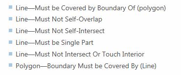
20 #2 Parcel Fabric Single, complete, trusted and sustainable (conversion and compilation)


21 Parcel Fabric Delivery Plan
22 Esri s Parcel Fabric Esri s parcel fabric was selected as the preferred data model and maintenance tool set for LTSA operations team because: 1. Commercial off-the-shelf (COTS) solution 2. Proven solution - implemented in various other large jurisdictions similar to BC (2 million parcels) 3. Least Squares Adjustments (LSA) engine to improve the fabric s spatial accuracy
 are captured and retained.")
23 Elements of a Parcel Esri s Parcel Fabric The best parcel fabric is one built from survey plans, whereby all observations (distances and bearings) are captured and retained. Plans 1 1-M Parcels 1 1-M 1 Points M Lines 0-1 Control 1-1 Line Points 0-M

24 Precision Input Example
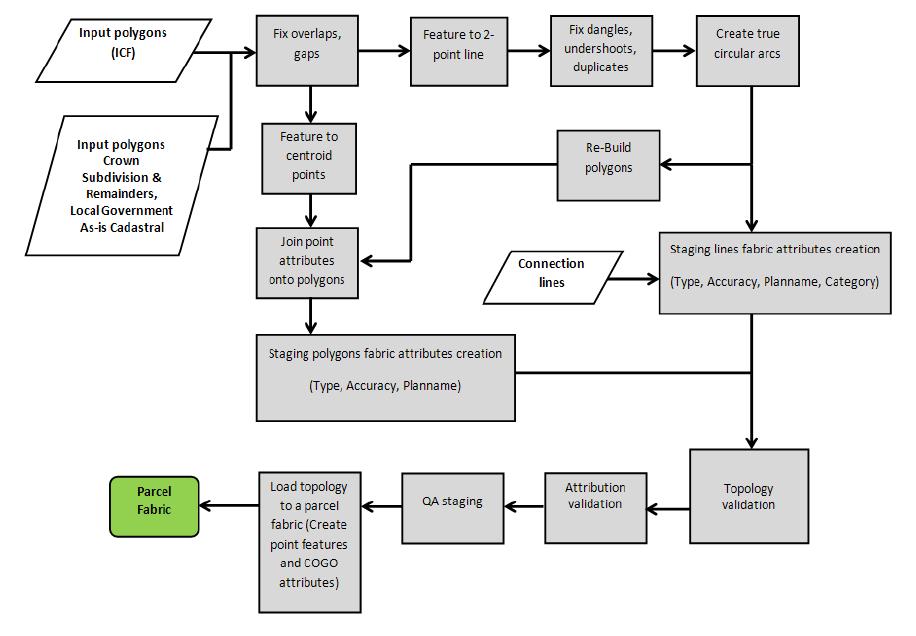


25 Generate Fabric-Ready Geometry - CPDM

26 Lessons Learned: Interesting Data Conditions

 Testing MNC")
27 Acceptance Process A test plan organizes the testing and acceptance process Total of 54 tests to ensure completeness and correctness Comprehensive increment and/or province-wide Random samples for visual inspection Lesson Learned review Acceptance Client (LTSA) Testing MNC Release Factory Testing
28 #3 Survey Plan Submissions Web based digital plan submission and checking system
29 Survey Plan Submissions (SPS) Innovative webmap application that helps BC land surveyors validate their digital survey plan quality online before submission to the LTSA for plan registration. The system runs custom geoprocessing services to perform various business rule checks. #3 SURVEY PLAN SUBMISSIONS: Built a web based application called Survey Plan Submission (SPS) to support B.C. s operational maintenance.


 2010")

30 Plan Submission & Checking Online The Benefits Reduced Errors & Costs Improved Quality User Friendly British Columbia Alberta Saskatchewan Visual Check for Users Survey Plan Submission (SPS) 2016 Survey Plan Online Checker (SPOC) 2010 Plan Submission Online (PSO) 2013 Faster Approvals Reduced Effort More Secure More Information and Detail
31 Submit Survey Plan Dataset CAD file, control point CSV file and metadata
32 Verify/View Dataset Validation Results

33 Parcel Topology Check Result

34 Perform Map Check


35 ParcelMap BC Input Fabric Compilation Output Land Title Register (Parcel Attribute Data) ICIS Source Parcels ICF Source Parcels 2 Million 1.7 Million 1.5 Million Extract, Transform and Load Cadastral Ties 65,400 Crown Primaries 76,000 Crown Subdivisions 173,000 Crown Transportation 107,000 Crown Undersurface 16,000 Crown SRW 31,000 Create New Data Cadastral Field Ties 2,600 Cadastral Ties from Plans 4,500 Catch-up Plans 2,500 Attribute Correction 55,000 Indian Reserves 1,450 Assessment Areas 19 Conservancy Areas 157 Federal Harbor & Port Authority 19 Integrated Survey Areas 53 Land Districts 7 Land Title Districts 61 Municipalities 160 National Parks 7 Parks and Protected Areas 924 Regional Districts 29 Precision Input of Missing Parcels 10,000 From Disparate Source Data to a Single, Complete, Trusted and Sustainable Parcel Fabric 2 Million Parcels Completed in 2½ Years Survey Plans 200,000
36 Project Status Project Start Jul 2014 Aug 2014 Sep 2014 Oct 2014 Nov 2014 Dec 2014 Jan 2015 Feb 2015 Mar 2015 Apr 2015 May 2015 Jun 2015 Jul 2015 Aug 2015 Sep 2015 Oct 2015 Nov 2015 Dec 2015 Jan 2016 Feb 2016 Mar 2016 Apr 2016 May 2016 Jun 2016 Jul 2016 Aug 2016 Sep 2016 Oct 2016 Nov 2016 Dec 2016 Jan 2017 Feb 2017 Mar 2017 Apr 2017 May 2017 Jun 2017 Field Tie Program PWL Province Wide Layers FCP Fabric Compilation Plan Acceptance Test Plan Ties from Survey Plans Inc. 1 Fabric Increments Accepted SPS Application Mandatory for Surveyors Increments Currently in Progress: Inc. A - target acceptance - April Inc. B - target acceptance - May Inc. C - target acceptance - June Inc. 2 Inc. 3 Inc. 5/6 Inc. 7/9 Inc. 11/12 Inc. 4/8 Inc. 10/13 Inc. 14/15 Project Completed Largest Parcel Fabric Implementation in Canada
37 Thank you! If you have any questions or would like more information please contact: or
ParcelMap BC Compiling a Parcel Fabric for the Province of British Columbia. Presented by: Ellen Styner (General Manager) and Wendy Amy (GIS Manager)
 and Wendy Amy (GIS Manager)") ParcelMap BC Compiling a Parcel Fabric for the Province of British Columbia Presented by: Ellen Styner (General Manager) and Wendy Amy (GIS Manager) Who is MNC? MNC is a geomatics engineering firm with
ParcelMap BC Compiling a Parcel Fabric for the Province of British Columbia Presented by: Ellen Styner (General Manager) and Wendy Amy (GIS Manager) Who is MNC? MNC is a geomatics engineering firm with
Overview 7/6/2016. Agenda. Introduction to ParcelMap BC LGMA Annual Conference Nanaimo, BC. ParcelMap BC Primary Goal
 Agenda Overview ParcelMap BC Primary Goal ParcelMap BC Key Benefits ParcelMap BC Advisory Committee BC Assessment Grant Program Introduction to ParcelMap BC LGMA Annual Conference Nanaimo, BC Mike Thomson
Spatial Data Warehouse Ltd. Cadastral Mapping INITIATIVE 1: CADASTRAL MAPPING. Version Spatial Data Warehouse Ltd. & AltaLIS Ltd.
 Spatial Data Warehouse Ltd. Initiative 1: Cadastral Mapping INITIATIVE 1: CADASTRAL MAPPING 29 P3 The SDW/AltaLIS Model Background The Government of Alberta started a mapping program, the Municipal Integrated
GOVERNMENT. Case Study Ville de Trois Rivières streamlines property assessment
 GOVERNMENT Case Study Ville de Trois Rivières streamlines property assessment GIS-generated parcel basemap provides powerful visualization & analysis capabilities With a population of just over 130,000,
Hybrid Cadastre Pilot Project Guidelines for Public Land Disposition Surveys Operations Division
 Hybrid Cadastre Pilot Project Guidelines Operations Division January 12, 2015 Version Update Version No. Date Summary of Changes 2.0 January 12, Table of Contents 2015 Table of Contents added to Guidelines.
City of Surrey s Digital Plan Submission Process
 City of Surrey s Digital Plan Submission Process Cadastral Update Karen Stewart, B.Tech. (GIS) Spatial Information Manager Peter Mueller, B.C.L.S., C.L.S. Survey Manager City of Surrey, British Columbia,
Certified Crisis Management Professional. Contents are subject to change. For the latest updates visit
 Certified Crisis Management Page 1 of 8 Why Attend This course provides participants with concrete crisis management solutions and strategies, while giving insight into the delivery of effective Crisis
Queens Rental Market Report February 2018 mns.com
 Queens Rental Market Report February 2018 TABLE OF CONTENTS 03 Introduction 04 A Quick Look 10 Queens Price Trends 11 Neighborhood Price Trends 11 Long Island City 12 Astoria 13 Ridgewood 14 Flushing 15
Public Disclosure Copy
 Public Disclosure Authorized EUROPE AND CENTRAL ASIA Kosovo Social, Urban, Rural and Resilience Global Practice Global Practice IBRD/IDA Investment Project Financing FY 2010 Seq No: 19 ARCHIVED on 10-Jan-2018
MLS of Greater Cincinnati - Charts for the Month: November 2017
 MLS of Greater Cincinnati - Charts for the Month: November 2017 The following charts provide an overview of what has occurred in the MLS over the past month. Each chart provides a historical trend. The
A CADASTRAL GEODATA BASE FOR LAND ADMINISTRATION USING ARCGIS CADASTRAL FABRIC MODEL A CASE STUDY OF UWANI ENUGU, ENUGU STATE, NIGERIA
 A CADASTRAL GEODATA BASE FOR LAND ADMINISTRATION USING ARCGIS CADASTRAL FABRIC MODEL A CASE STUDY OF UWANI ENUGU, ENUGU STATE, NIGERIA BY Ndukwu, Raphael. Ike Department of Geoinformatics & Surveying University
First Nations Land Registry
 First Nations Land Registry Making Sense of the ILRS Steven Patterson, Sitka Geomatics Inc. www.sitkageo.com Land Titles a brief history Land titles were traditionally managed within the community, and
PREPARING SURVEY TENDER GIS DATABASE OUTCOMES
 PREPARING SURVEY TENDER SPECIFICATIONS FOR PROJECT GIS DATABASE OUTCOMES Presentation by Ian Harper GEODATA AUSTRALIA ESRI User Conference 2009 24 st July 2009 BACKGROUND GIS databases now provide a more
The University of Massachusetts Campus Master Plan. Faculty Senate April 21st
 The University of Massachusetts Campus Master Plan Faculty Senate April 21st Update on process and schedule 2011 Summer 2012 Oct Nov Dec Jan Feb Mar Apr May Jun Jul Aug Sep Oct Nov Dec Jan Feb Mar Apr
An Overview of the eplan Journey with a Focus on the Victorian eplan 2025 Roadmap Dr Hamed Olfat
 An Overview of the eplan Journey with a Focus on the n eplan 2025 Roadmap Dr Hamed Olfat eplan Coordinator Land Use Chairman of Technical Committee ICSM eplan Working Group Outline eplan Overview ICSM
Modernizing Land Administration Systems
 Presented at the FIG Congress 2018, May 6-11, 2018 in Istanbul, Turkey Modernizing Land Administration Systems B r e n t J o n e s P E, PLS E s r i Land Administration Systems GIS is the Technology Platform
Online Cadastre and Tantalis GATOR
 Online Cadastre and Tantalis GATOR Online Cadastre Free, public online access to BC Crown land cadastral information and other geographic data LTSA is responsible for maintenance of and enhancements to
New Technology for Cadastral Systems. Brent Jones, PE, PLS
 New Technology for Cadastral Systems Brent Jones, PE, PLS Benefits of Good Land Administration Key to addressing global challenges.. Secure Tenure Equitable Land and Property Taxation Support for Government
Using GIS To Manage Surface Ownership and Right-Of-Way
 Using GIS To Manage Surface Ownership and Right-Of-Way Jeff Bute - Sr. Land Maintenance Rep. / GIS Analyst Jeff was formerly a Property Tax Right of Way and Claims field agent for the company. Now he uses
Mineral Resources Authority (MRA) FlexiCadastre Papua New Guinea
 FlexiCadastre Papua New Guinea") Mineral Resources Authority (MRA) FlexiCadastre Papua New Guinea Louie Kawale Mining Management System Administrator Margaret Aulda Senior Technical Assessment Officer Nancy Wafiwa Assessment Geologist
Mineral Resources Authority (MRA) FlexiCadastre Papua New Guinea Louie Kawale Mining Management System Administrator Margaret Aulda Senior Technical Assessment Officer Nancy Wafiwa Assessment Geologist
Implementation Status & Results Macedonia, former Yugoslav Republic of Real Estate Cadastre & Registration Project (P083126)
") Public Disclosure Authorized Public Disclosure Authorized Implementation Status & Results Macedonia, former Yugoslav Republic of Real Estate Cadastre & Registration Project (P083126) Operation Name: Real
Public Disclosure Authorized Public Disclosure Authorized Implementation Status & Results Macedonia, former Yugoslav Republic of Real Estate Cadastre & Registration Project (P083126) Operation Name: Real
General Instructions For Surveys and Plans Outside the Provincial Survey System
 May 15, 2018 General Instructions For Surveys and Plans Outside the Provincial Survey System NOTE: This document is a Controller of Surveys Policy manual to be used as a general guideline for the Legal
Land Administration and Spatial Enablement Victoria s Experience. Chris McRae, Executive Director Land Victoria
 Land Administration and Spatial Enablement Victoria s Experience Chris McRae, Executive Director Land Victoria 4 th UN Land Administration Forum, October 2011 Outline About Land Victoria Land Victoria
SFR Condo Residential Lot Sales Inventory Sales Inventory Sales Inventory. Month YTD Month Month YTD Month Month YTD Month
 Grand Strand Market Report 2017 capped off a great year for the Grand Strand as full year SFR sales volume and median sales price were up 9.8% and 4.3%, respectively. Condo sales activity increased 3.0%
LADM-based Crowdsourced 3D Cadastral Surveying Potential and Perspectives
 National Technical University Of Athens School of Rural and Surveying Engineering LADM-based Crowdsourced 3D Cadastral Surveying Potential and Perspectives Maria Gkeli, Surveying Engineer, PhD student
Queens Rental Market Report November 2017 mns.com
 Queens Rental Market Report November 2017 TABLE OF CONTENTS 03 Introduction 04 A Quick Look 10 Queens Price Trends 11 Neighborhood Price Trends 11 Long Island City 12 Astoria 13 Ridgewood 14 Flushing 15
Implementation Status & Results Macedonia, former Yugoslav Republic of Real Estate Cadastre & Registration Project (P083126)
") Public Disclosure Authorized Public Disclosure Authorized Implementation Status & Results Macedonia, former Yugoslav Republic of Real Estate Cadastre & Registration Project (P083126) Operation Name: Real
Public Disclosure Authorized Public Disclosure Authorized Implementation Status & Results Macedonia, former Yugoslav Republic of Real Estate Cadastre & Registration Project (P083126) Operation Name: Real
The New Technology of a Survey Data Model and Cadastral Fabric as the Foundation for a Future Land Administration System.
 The New Technology of a Survey Data Model and Cadastral Fabric as the Foundation for a Future Land Ian HARPER, Australia Key words: cadastral modelling, survey data model, Survey Accuracy, Cadastre 2014
Egyptian Nationwide Title Cadastre System
 Kholoud SAAD, Egypt Key words: Cadastre, Registration, Urban, Rural, National Cadastre, Automation, reengineering. SUMMARY With growing need for integrated information, Enterprise Solutions has become
Manhattan Rental Market Report March 2016 mns.com
 Manhattan Rental Market Report March 2016 TABLE OF CONTENTS 03 Introduction 04 A Quick Look 07 Mean Manhattan Rental Prices 11 Manhattan Price Trends 12 Neighborhood Price Trends 12 Battery Park City 13
The Cadastral Modelling Future and The Land Surveyors Role
 The Cadastral Modelling Future and The Land Surveyors Role Ian Harper Geodata Australia ESRI Survey Summit July 2013 The Land Surveyors Future Role From Custodians of the Cadastre to Custodians of the
Housing Bulletin Monthly Report
 February 21 1 Housing Bulletin Monthly Report Housing Starts 25, 2, 15, 1, 5, Alberta Housing Starts up 5 per cent from 29 From February 29 to 21, preliminary housing starts increased 82.7 per cent across
Competitive Strategies and Value Innovation. Contents are subject to change. For the latest updates visit
 Competitive Strategies and Value Innovation Page 1 of 9 Why Attend This course introduces key concepts, tools, and principles of strategic management allowing managers to create their organization's unique
Released: April 8, 2011
 Released: April 8, 2011 Commentary 2 The Numbers That Drive Real Estate 3 Special Report 9 Brought to you by: KW Research Commentary The housing market continues on a relatively stable and balanced track.
The Survey Data Model Technology A practical survey solution to generate all levels of spatial and e-governance outcomes.
 Land Governance in a Rapidly Changing Environment Annual World Bank Conference on Land and Poverty April 24 & 25, 2012 The Survey Data Model Technology A practical survey solution to generate all levels
The World Bank Integrated Land Administration System Project (P122219)
") Public Disclosure Authorized EUROPE AND CENTRAL ASIA Croatia Social, Urban, Rural and Resilience Global Practice Global Practice IBRD/IDA Investment Project Financing FY 2012 Seq No: 14 ARCHIVED on 07-Dec-2017
Public Disclosure Authorized EUROPE AND CENTRAL ASIA Croatia Social, Urban, Rural and Resilience Global Practice Global Practice IBRD/IDA Investment Project Financing FY 2012 Seq No: 14 ARCHIVED on 07-Dec-2017
Manhattan Rental Market Report December 2017 mns.com
 Manhattan Rental Market Report December 2017 TABLE OF CONTENTS 03 Introduction 04 A Quick Look 07 Mean Manhattan Rental Prices 11 Manhattan Price Trends 12 Neighborhood Price Trends 12 Battery Park City
Brooklyn Rental Market Report June 2013 mns.com
 Brooklyn Rental Market Report June 2013 TABLE OF CONTENTS 03 Introduction 04 A Quick Look 05 Mean Brooklyn Rental Prices 07 Brooklyn Price Trends 08 Neighborhood Price Trends 08 Bay Ridge 09 Bedford-Stuyvesant
Cloud GIS Real Estate Management, Appraisal and Development Service USING ESRIs ARCGIS SERVER
 Cloud GIS Real Estate Management, Appraisal and Development Service USING ESRIs ARCGIS SERVER INFODIM: Was founded on 1992 and is internationally certified as a GIS company from D&B Dun & Bradstreet Global
England Occupancy Survey May 2017 SUMMARY OF RESULTS
 England Occupancy Survey 2017 SUMMARY OF RESULTS Room occupancy in 2017 increased +1% to 73%. Bedspace occupancy also increased +1% to 54%. Weekday room occupancy remained stable at 72% whilst weekend
Efficient Finance and Accounting Operations: 2019 Best Practices and Updates
 Efficient Finance and Accounting Operations: 2019 Best Practices and Updates Page 1 of 11 Why Attend Stop what you are doing, take a step back, and look at how you perform your work. You will probably
Implementation Status & Results Macedonia, former Yugoslav Republic of Real Estate Cadastre & Registration Project (P083126)
") Public Disclosure Authorized Public Disclosure Authorized The World Bank Implementation Status & Results Macedonia, former Yugoslav Republic of Real Estate Cadastre & Registration Project (P083126) Operation
Public Disclosure Authorized Public Disclosure Authorized The World Bank Implementation Status & Results Macedonia, former Yugoslav Republic of Real Estate Cadastre & Registration Project (P083126) Operation
1. INTRODUCTION PURPOSE APPLICABILITY... 3
 STANDARD OPERATING PROCEDURE CADASTRAL BASE MAPPING SECTION BASE MAPPING AND GEOMATICS SERVICES BRANCH, MINISTRY OF SUSTAINABLE RESOURCES MANAGEMENT TABLE OF CONTENTS 1. INTRODUCTION... 3 2. PURPOSE...
Information sheet A Data
 House prices: Statistics activity House prices change over time, but do so at different rates in different places. In this activity you will use statistical diagrams and measures to compare house prices
A Geocoded Cadastral Fabric as a Precondition for a Sustainable Land Management System
 A Geocoded Fabric as a Precondition for a Sustainable Land Management System Gottfried KONECNY, Germany; J.P. LAUZON, Canada; Abdul Salam MOHAMMED, India Key words: SDI,, Parcel Boundaries, GPS-GNSS, Land
Using ArcGIS Server for National Property Information System
 Using ArcGIS Server for National Property Information System Shota Chachkhunashvili (National Agency of Public Registry, Georgia) Mikheil Tsiklauri (Geographic, Georgia) San Diego, 2008 About us National
The Effective Analyst: From Research to Execution. Contents are subject to change. For the latest updates visit
 The Effective Analyst: From Research to Page 1 of 8 Why Attend Solving problems in the business world is essential to keeping things moving along smoothly. While problems differ in complexity, almost all
Brooklyn Rental Market Report April 2015 mns.com
 Brooklyn Rental Market Report April 2015 TABLE OF CONTENTS 03 Introduction 04 A Quick Look 05 Mean Brooklyn Rental Prices 10 Brooklyn Price Trends 11 Neighborhood Price Trends 11 Bay Ridge 12 Bedford-Stuyvesant
Innovations in Education at Faculty ITC and within Land Administration Programme
 Innovations in Education at Faculty ITC and within Land Administration Programme Prof. Jaap Zevenbergen, Vice-Dean Education at Faculty ITC, Prof. Land Administration dr. Dimo Todorovski, Course Coordinator
Housing Bulletin Monthly Report
 October 21 1 Housing Bulletin Monthly Report Housing Starts show Slight improvement in September CANADA Housing Starts 2, 15, 1, 5, Sep 8 Oct 8 Nov 8 Dec 8 Preliminary Housing Starts in Alberta and Canada
NEW HOMES REGISTRY REPORT
 December 218 British Columbia s Monthly NEW HOMES REGISTRY REPORT Leading Housing Market Indicator for B.C. Registered new homes data are a leading indicator of housing and economic 1 activity in British
Manhattan Rental Market Report April 2016 mns.com
 Manhattan Rental Market Report April 2016 TABLE OF CONTENTS 03 Introduction 04 A Quick Look 07 Mean Manhattan Rental Prices 11 Manhattan Price Trends 12 Neighborhood Price Trends 12 Battery Park City 13
Certified Internal Auditor Exam Preparation. Contents are subject to change. For the latest updates visit
 Certified Internal Auditor Exam Preparation Page 1 of 11 Why Attend This preparatory course is designed to equip candidates with the knowledge and skills required to write and pass the Certified Internal
July 2012 was $162,256. ($153,956). was $314,607. was $172,488. ($164,426). Kansas City Region Average Sales Price - Existing Homes
. was $314,607. was $172,488. ($164,426). Kansas City Region Average Sales Price - Existing Homes") July 212 Kansas City Regional Real Estate Market Report Average Sales Price The average exis ng home sale price in July 212 was $162,256. 25 Kansas City Region Average Sales Price - Existing Homes July
July 212 Kansas City Regional Real Estate Market Report Average Sales Price The average exis ng home sale price in July 212 was $162,256. 25 Kansas City Region Average Sales Price - Existing Homes July
Public Disclosure Copy
 Public Disclosure Authorized EUROPE AND CENTRAL ASIA Tajikistan Agriculture and Rural Development Global Practice IBRD/IDA Specific Investment Loan FY 2005 Seq No: 27 ARCHIVED on 01-Jun-2015 ISR19129 Implementing
Housing Bulletin Monthly Report
 December 21 1 Housing Bulletin Monthly Report Alberta Housing Starts Fall in November 21 Canada Housing Starts 25 2 15 1 5 8 NOV 8 DEC 8 Preliminary Housing Starts in Alberta* and Canada* November 28 to
CATALOGING, MONITORING AND MANAGING INVASIVE SPECIES ON POST LANDS. PSU Geog596A Capstone Proposal Dale Jantzen Dec 17, 2015
 CATALOGING, MONITORING AND MANAGING INVASIVE SPECIES ON POST LANDS PSU Geog596A Capstone Proposal Dale Jantzen Dec 17, 2015 PROJECT OUTLINE AND PURPOSE Define a particular need within a non-profit land
Housing Bulletin Monthly Report
 January 21 1 Housing Bulletin Monthly Report Most new homes built in second half of 29 25, 2, 15, 1, 5, Dec 7 Jan 8 Feb 8 mar 8 apr 8 Alberta s 29 housing starts increased 72.8 per cent over 28, suggesting
Affiliate Appraiser Pak
 Affiliate Appraiser Pak Thank you for your interest in Affiliate Appraiser Membership with PAR. Attached are the required forms you will need to complete in order to join. It is your responsibility to
MonthlyStatistics FEBRUARY 2018
 MonthlyStatistics FEBRUARY 2018 FOR IMMEDIATE RELEASE March 1, 2018 Buoyant Sellers Market Continues NANAIMO, BC Last month, 316 single-family homes sold on the Multiple Listing Service (MLS ) System compared
MonthlyStatistics MARCH 2018
 MonthlyStatistics MARCH 2018 FOR IMMEDIATE RELEASE April 3, 2018 Sales Down From 2017 But Prices Still Rising Due to Limited Inventory NANAIMO, BC Sales of single-family homes, apartments, and townhouses
Housing Bulletin Monthly Report
 February 211 1 Housing Bulletin Monthly Report Alberta s preliminary housing starts declined in January 211 Canada Housing Starts 25, 2, 15, 1, 5, DEC 8 JAN 9 Preliminary Housing Starts in Alberta* and
Released: October 2011
 Released: October 2011 Commentary 2 The Numbers That Drive Real Estate 3 Special Report 9 Brought to you by: KW Research Commentary The national housing market remains firmly planted in balanced territory.
Modernizing the Land Titles System in Yukon. What We Heard Report
 What We Heard Report Yukon Department of Justice Fall, 2012 What We Heard Report Table of Contents What We Heard Report... 2 1. What We Heard about the Appropriate System for Recording Land Interests in
Manhattan Rental Market Report March 2018 mns.com
 Manhattan Rental Market Report March 2018 TABLE OF CONTENTS 03 Introduction 04 A Quick Look 07 Mean Manhattan Rental Prices 11 Manhattan Price Trends 12 Neighborhood Price Trends 12 Battery Park City 13
Agenda Project Overview Project Objectives Registration Service Re-Engineering System Overview
 Agenda Project Overview Project Objectives Registration Service Re-Engineering System Overview Sydney, Australia, 11 16 April 2010 1 Project Overview Future Vision There is a vision within senior levels
Economic Spotlight September 1, 2009
 Economic Spotlight September 1, 29 Update on Alberta s Housing Market Summary Alberta s housing market is beginning to show signs of recovery. Housing starts have rebounded from March lows and activity
Manhattan Rental Market Report January 2018 mns.com
 Manhattan Rental Market Report January 2018 TABLE OF CONTENTS 03 Introduction 04 A Quick Look 07 Mean Manhattan Rental Prices 11 Manhattan Price Trends 12 Neighborhood Price Trends 12 Battery Park City
Shaping the Cadastral Infrastructure for a Digital Future
 DEPARTMENT OF LANDS PLANNING and the ENVIRONMENT Shaping the Cadastral Infrastructure for a Digital Future Craig Sandy Director Surveys Surveyor General Survey Branch NT Australia Digital Cadastral Databases
Demonstrate knowledge of, and extract, cadastral data from Landonline
 Page 1 of 5 Demonstrate knowledge of, and extract, cadastral data from Landonline Level 3 Credits 5 Purpose This unit standard is for people who are working in the surveying industry in jobs which involve
Monthly Indicators % % %
 Monthly Indicators 2016 Percent changes calculated using year-over-year comparisons. New Listings were down 27.6 percent for single family homes and 41.8 percent for townhouse-condo properties. Pending
Brooklyn Rental Market Report July 2016 mns.com
 Brooklyn Rental Market Report July 2016 TABLE OF CONTENTS 03 Introduction 04 A Quick Look 05 Mean Brooklyn Rental Prices 10 Brooklyn Price Trends 11 Neighborhood Price Trends 11 Bay Ridge 12 Bedford-Stuyvesant
Monthly Indicators % + 9.7% %
 Monthly Indicators 2016 Percent changes calculated using year-over-year comparisons. New Listings were up 11.1 percent for single family homes and down 30.8 percent for townhouse-condo properties. Pending
Puerto Rico Housing Finance Authority Housing Stimulus Programs
 Puerto Rico Housing Finance Authority Housing Stimulus Programs March 31, 2012 (Final with US Data) Total sales assisted by PRHFA stimulus from $240MM Fund Assignment As of March 31, 2012 Silent Second
TOWARDS E-LAND ADMINISTRATION - ELECTRONIC PLANS OF SUBDIVISIONS IN VICTORIA
 TOWARDS E-LAND ADMINISTRATION - ELECTRONIC PLANS OF SUBDIVISIONS IN VICTORIA Mohsen Kalantari 1, Chris Lester 2, David R Boyle 3, Neil Coupar 4 1 eplan Coordinator 2 SPEAR Manager 3 Deputy Surveyor General
Queens Rental Market Report October 2017 mns.com
 Queens Rental Market Report October 2017 TABLE OF CONTENTS 03 Introduction 04 A Quick Look 10 Queens Price Trends 11 Neighborhood Price Trends 11 Long Island City 12 Astoria 13 Ridgewood 14 Flushing 15
Roles, Responsibilities and Relationships About MPAC Property Assessment in Ontario Updates to Assessment Values in Year Products and Services Role
 Roles, Responsibilities and Relationships About MPAC Property Assessment in Ontario Updates to Assessment Values in Year Products and Services Role of Municipal Relations Outreach Initiatives 2012 Assessment
CLICK HERE TO KNOW MORE
 CLICK HERE TO KNOW MORE LANDS AND SURVEYS DEPARTMENT SABAH, MALAYSIA GEO-CADASTRE IN LAND ADMINISTRATION: SABAH S EXPERIENCE Sr Hj SAFAR B UNTONG, FISM, MRICS Director, Lands & Surveys Department Sabah,
THE VALUE PROPOSITION OF A STRONG INDUSTRY ASSOCIATION SCOTT ANDISON
 THE VALUE PROPOSITION OF A STRONG INDUSTRY ASSOCIATION SCOTT ANDISON JANUARY 15, 2016 THE LINE UP THE FRPO BRAND INDUSTRY PROFILE THE NEED FOR INDUSTRY ADVOCACY SELECT POLICY PRIORITIES QUESTIONS 2 Professional
Implementation Status & Results Macedonia, former Yugoslav Republic of Real Estate Cadastre & Registration Project (P083126)
") Public Disclosure Authorized Public Disclosure Authorized Implementation Status & Results Macedonia, former Yugoslav Republic of Real Estate Cadastre & Registration Project (P083126) Operation Name: Real
Public Disclosure Authorized Public Disclosure Authorized Implementation Status & Results Macedonia, former Yugoslav Republic of Real Estate Cadastre & Registration Project (P083126) Operation Name: Real
MonthlyStatistics APRIL 2018
 MonthlyStatistics APRIL 2018 FOR IMMEDIATE RELEASE May 1, 2018 Sales Holding Steady Amid Rising House Prices NANAIMO, BC Sales of single-family homes in the VIREB area rose by 20 per cent month over month
The World Bank Turkey Land Registration and Cadastre Modernization Project (P106284)
") Public Disclosure Authorized EUROPE AND CENTRAL ASIA Turkey Social, Urban, Rural and Resilience Global Practice Global Practice IBRD/IDA Specific Investment Loan FY 2008 Seq No: 19 ARCHIVED on 30-Jun-2017
Public Disclosure Authorized EUROPE AND CENTRAL ASIA Turkey Social, Urban, Rural and Resilience Global Practice Global Practice IBRD/IDA Specific Investment Loan FY 2008 Seq No: 19 ARCHIVED on 30-Jun-2017
REQUEST FOR PROPOSALS
 REQUEST FOR PROPOSALS Coastal LiDAR Mapping Closing date and time: 4:00 pm on Monday, May 9, 2016 Closing Location: Regional District of Nanaimo Strategic & Community Development 6300 Hammond Bay Road
Meeting the Changing National Geospatial Information Needs. Palitha Udayakantha Surveyor General - Sri Lanka
 Meeting the Changing National Geospatial Information Needs Palitha Udayakantha Surveyor General - Sri Lanka Sri Lanka Location Latitude 5 55 10-9 50 6 North Longitude 79 31 19-81 52 36 East Area 65610
Flood Hazard Modelling
 Flood Hazard Modelling Identification Information Dataset Name: Rapid Flood Hazard Model, Detailed Flood Hazard Model Dataset Abstract: The flood hazard model identifies areas that may be subject to flooding
Cadastral services and virtual office in e-cadastre
 Cadastral services and virtual office in e-cadastre Priit Kuus Estonian Land Board October 26, 2016 Coimbra Scope of data Cadastral parcels (as of September 2016) 674 383 cadastral parcels, i.e. 97,7 %
ANNOUNCEMENT OF PHASE 2 REQUIREMENTS TO FILE LAND TITLE FORMS ELECTRONICALLY
 ANNOUNCEMENT OF PHASE 2 REQUIREMENTS TO FILE LAND TITLE FORMS ELECTRONICALLY October 31, 2011 Pursuant to s. 168.111 of the Land Title Act, I am announcing the second phase of requirements to file certain
M onthly arket. July Table of Contents. Monthly Highlights
 Table of Contents Market Inventory...2 www.gaar.com Monthly Highlights The median sale price of single-family, detached homes climbed to $190,000 in July 2014, the highest level since August 2008. Market
Process Plant Inspection. Contents are subject to change. For the latest updates visit Page 1 of 7
 Process Plant Inspection Page 1 of 7 Why Attend Facing competitive industry and strong global competition, it is critical that organizations gain the most from their equipment and plant, while protecting
Fit-for Purpose Approaches to Land Administration
 Fit-for Purpose Approaches to Land Administration Brent Jones, PE, PLS Global Manager, Casastre/Land Records bjones@esri.com Land Administration GIS is the platform for land administration Land administration
The World Bank Turkey Land Registration and Cadastre Modernization Project (P106284)
") Public Disclosure Authorized EUROPE AND CENTRAL ASIA Turkey Social, Urban, Rural and Resilience Global Practice Global Practice IBRD/IDA Investment Project Financing FY 2008 Seq No: 20 ARCHIVED on 20-Dec-2017
Public Disclosure Authorized EUROPE AND CENTRAL ASIA Turkey Social, Urban, Rural and Resilience Global Practice Global Practice IBRD/IDA Investment Project Financing FY 2008 Seq No: 20 ARCHIVED on 20-Dec-2017
UNITED KINGDOM OCCUPANCY SURVEY. Serviced Accommodation Summary Report April the research solution
 UNITED KINGDOM OCCUPANCY SURVEY Serviced Accommodation Summary Report April 2017 the research solution OCCUPANCY SURVEY This study has been commissioned by the National Boards of England, Ireland and Scotland
GAUSSCAD A WEBGIS APPLICATION FOR COLLECTING CADASTRAL DATA
 M.M. Moise GaussCAD a WebGIS Application for Collecting Cadastral Data GAUSSCAD A WEBGIS APPLICATION FOR COLLECTING CADASTRAL DATA Mihai-Mircea MOISE, S.C. GAUSS S.R.L., mihai.moise@gauss.ro Abstract:
Home Inspector Qualifications
 Home Inspector Qualifications Introductory Stakeholder Meeting June 25, 2013 Introductions Today s Goals Engagement approach and plan going forward Work to date 2 Public Commitment This fall, as part of
Directorate of Survey and Mapping NAMIBIA. Cadastral Information System. Vehupisa Kasuko Tjatindi Surveyor Directorate of Survey and Mapping NAMIBIA
 Vehupisa Kasuko Tjatindi Directorate of Survey and Mapping NAMIBIA Tel: +64 61 965000 Directorate of Survey and Mapping NAMIBIA Cadastral Information System Introduction Over the past few decades cadastral
Commentary 2. Released: May The Numbers That Drive Real Estate 3. Special Report 9. Brought to you by: KW Research
 Released: May 2011 Commentary 2 The Numbers That Drive Real Estate 3 Special Report 9 Brought to you by: KW Research Commentary Despite lingering effects from regulatory changes in the mortgage markets,
Implementation Status & Results Colombia Bogota Urban Services Project (P074726)
") Public Disclosure Authorized Public Disclosure Authorized The World Bank Implementation Status & Results Colombia Bogota Urban Services Project (P074726) Operation Name: Bogota Urban Services Project (P074726)
Public Disclosure Authorized Public Disclosure Authorized The World Bank Implementation Status & Results Colombia Bogota Urban Services Project (P074726) Operation Name: Bogota Urban Services Project (P074726)
Monthly Indicators + 7.3% + 6.6% + 8.3% Single-Family Market Overview Condo Market Overview New Listings Pending Sales.
 Monthly Indicators 2018 The three most prominent national market trends for residential real estate are the ongoing lack of abundant inventory, the steadily upward movement of home prices and year-over-year
Accounting and Finance Policies and Procedures. Contents are subject to change. For the latest updates visit
 Policies and Procedures Page 1 of 11 Why Attend Accounting and finance policies and procedures are the most efficient way to implement company-wide effective internal control tools in any organization.
Engr. Juan P. Fernandez, Jr. Chief, Surveys and Mapping Division DENR Region-3 Club Royale Hotel, Malolos, Bulacan February 27,2016
 Engr. Juan P. Fernandez, Jr. Chief, Surveys and Mapping Division DENR Region-3 Club Royale Hotel, Malolos, Bulacan February 27,2016 ! DAO 2007-29 issued on July 31, 2007 re Revised Regulations on Land