LADM-based Crowdsourced 3D Cadastral Surveying Potential and Perspectives
|
|
|
- Natalie Little
- 5 years ago
- Views:
Transcription

1 National Technical University Of Athens School of Rural and Surveying Engineering LADM-based Crowdsourced 3D Cadastral Surveying Potential and Perspectives Maria Gkeli, Surveying Engineer, PhD student Dr. Chryssy Potsiou, Professor Dr. Charalabos Ioannidis, Professor Gkeli, M., Chryssy, P., & Ioannidis, C., LADM-based Crowdsourced 3D Cadastral Surveying Potential and Perspectives. In: 6th International FIG Workshop on 3D Cadastres,
 Spatial domain standard flexible conceptual schema for 2D/3D Cadastres based on a Model Driven Architecture (MDA) The identification of the")
2 Introduction Current Situation: Vertically growing cities Complex infrastructure Subdivision of three-dimensional (3D) space Overlapping property rights A modern land administration system (LAS) is needed Land Administration Domain Model (LADM ISO 19152) Spatial domain standard flexible conceptual schema for 2D/3D Cadastres based on a Model Driven Architecture (MDA) The identification of the acceptable 3D geometries and representations for the 3D cadastral objects is still challenging Workshop on 3D Cadastres,
3 3D Aspect of LADM 3D LADM-based country profiles: Russian Federation Poland Korea Greece Malaysia Linking LADM with physical models: Legal data model Legislation Cadastral background Physical data model High demand of required time and cost Application schemas Technical models (CityGML, IndoorGML, BIM/IFC, LandXML, InfraGML, etc.) Workshop on 3D Cadastres,
4 The potential use of crowdsourcing for 3D cadastral surveys Current research trends: Low-cost equipment & IT tools Crowdsourcing techniques Mobile services (m-services) & Web services Open-source software (OSS) 2D Crowdsourcing cadastral surveys Minimize cost and the time of the required surveys Crowdsourcing in 3D cadastral surveys: Parametric modelling methods (Model-driven) Best Fitted Solution high robustness, maintenance of topology can be adopted by parties without specific photogrammetric skills A fit-for-purpose 3D crowdsourced cadastral surveying approach based on standardized data model as LADM, might be of significant value to speed up processes for establishing 3D cadastres Workshop on 3D Cadastres,
5 Proposed Framework Proposed Framework Technical Aspects Crowdsourcing Procedure Server-side LADM-based DBMS Client-side Open-sourced mobile application for Android Cost-effective LADM-based technical solution Acquisition Registration 3D modelling Visualization Workshop on 3D Cadastres,

 (1/2) Workshop on")
6 Enterprise Architect UML modeling tool ArcGIS Geodatabase 6th International FIG Workshop on 3D Cadastres Database Management System (DBMS) (1/2) Workshop on 3D Cadastres,


")
7 Enterprise Architect UML modeling tool ArcGIS Geodatabase 6th International FIG Workshop on 3D Cadastres Database Management System (DBMS) (2/2) Workshop on 3D Cadastres,
8 3D Crowdsourcing Self-developed Mobile Application (1/2) Self-developed open-sourced Mobile Application 3D cadastral data acquisition 3D modelling of real properties (LoD1) Land Parcel & Property Unit Model-driven approach 3D visualization above & below the terrain Software tools: Visual Studio 2013 (IDE) Oracle JDK 8 (Java Development Kit) Android SDK Manager (for API level 19), add-in ArcGIS Runtime SDK for.net ( ) of ESRI add-in Xamarin the SharpKML library the programming language of C#, the Server of ArcGIS Online (Cloud of ESRI) Workshop on 3D Cadastres,

 Workshop on 3D")
9 3D Crowdsourcing Self-developed Mobile Application (2/2) Workshop on 3D Cadastres,
10 Proposed Procedure for 3D Cadastral Surveys (1/2) Provision of the available basemap with the areas under cadastral survey or recent orthophoto overlaid with buildings floor plans Higher geometric accuracy Orthophoto or aerial photo with the areas under cadastral survey Lower geometric accuracy Crowdsourced 3D cadastral information/data acquisition Cadastral Mobile Application Demarcation / digitization of the property boundaries Insertion of additional geometric information: building height, floor Insertion of additional descriptive information: rights holder s personal data, type of rights, etc. Verification images and legal documents 3D Parametric reconstruction of the building Workshop on 3D Cadastres,
11 Proposed Procedure for 3D Cadastral Surveys (2/2) Crowdsourced 3D cadastral information/data acquisition Cadastral Mobile Application Help needed? Provided either by volunteers or by professionals Demonstration videos of the mobile/web applications by NCMA Data evaluation and control by the cadastral service Incomplete Data? Submission of missing data by rights holders Compilation of preliminary crowdsourced 3D building models by right holders Workshop on 3D Cadastres,


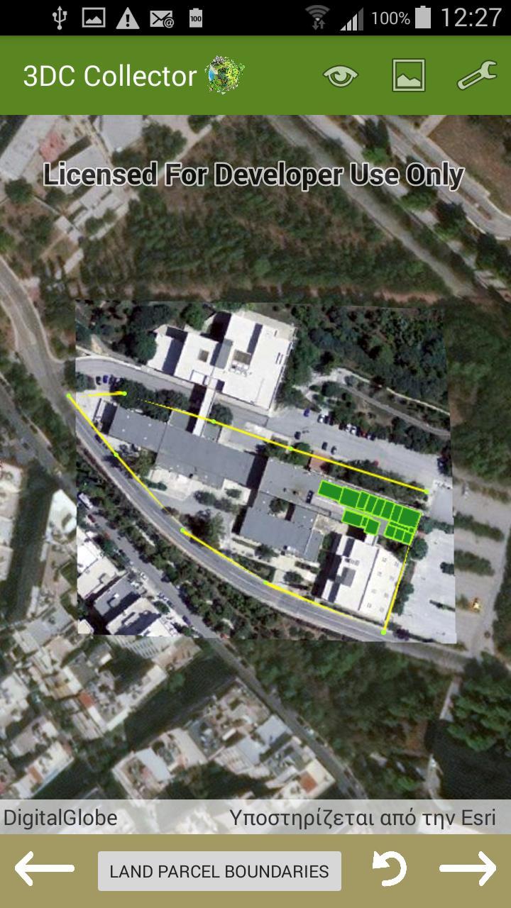
12 Case Study (1/4) Acquisition of Crowdsourced 3D cadastral information/data: The room-outline coordinates The building area code, address The room holder name, role, type of rights The room floor, height, use, area size, volume Basemaps: Orthophoto at the scale of 1:1000 Floor plans of: the underground floor the ground floor the first and the second floor at a scale of 1:200 Workshop on 3D Cadastres,
")
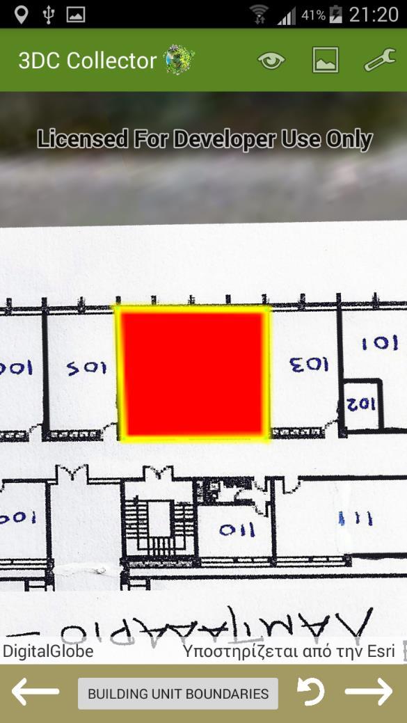
13 Case Study (2/4) Registration procedure: Workshop on 3D Cadastres,
 Workshop on 3D")
14 3D Visualization of the declared properties - LoD1 (Parametric Modelling) 6th International FIG Workshop on 3D Cadastres Case Study (3/4) Workshop on 3D Cadastres,


15 Case Study (4/4) Result evaluation : Comparison with the reference data: Maximum deviation: 0.49m Minimum deviation: 0.03m Average deviation: 0.17m Qualitative 3D models correct 3D position small shape defects Recording time per property: 5-7 min fast Easy-to-use Workshop on 3D Cadastres,
16 Conclusions A cost effective solution is required for the initial implementation of a EU desired 3D Cadastre Modern Approach - 3D Cadastral Surveys: 3D Crowdsourcing Techniques - Citizens participation errors minimization Cost effective and time consuming solution / automation usage of modern low-cost IT tools, m-services, parametric modelling techniques Land Administration Domain Model (LADM ISO 19152) Available cartographic infrastructure Generalized technical framework for the initial registration of 3D crowdsourced cadastral data and the creation of a standardize cadastral database for both the developed and developing world Workshop on 3D Cadastres,


17 Thank you for your attention! National Technical University Of Athens School of Rural and Surveying Engineering Maria Gkeli, Surveying Engineer, PhD student Dr. Chryssy Potsiou, Professor Dr. Charalabos Ioannidis, Professor Gkeli, M., Chryssy, P., & Ioannidis, C., LADM-based Crowdsourced 3D Cadastral Surveying Potential and Perspectives. In: 6th International FIG Workshop on 3D Cadastres,
A FIRST ATTEMPT FOR USING VOLUNTEERED GEOGRAPHIC INFORMATION AND CROWD SOURCING TECHNIQUES IN CADASTRE
 A FIRST ATTEMPT FOR USING VOLUNTEERED GEOGRAPHIC INFORMATION AND CROWD SOURCING TECHNIQUES IN CADASTRE Sofia Basiouka National Technical University of Athens PhD student s.basiouka@gmail.com Chryssy Potsiou
Hungarian Cadastre and its relation to LADM
 Hungarian Cadastre and its relation to LADM Gyula IVÁN CLGE General Assembly 22 March 2013, Budapest, HUNGARY Content Historical background Evolution of Cadastral modeling in Hungary LADM issues Conclusion
LRIMS Cadastre Module
 LRIMS Cadastre Module User Requirements and Functionality (Seychelles Case Study) John Latham, NRL Renato Cumani, NRL Luigi Simeone, NRL Summary Background User Requirements Business Model Application
Country report, HUNGARY
 Country report, HUNGARY Gyula IVÁN Institute of Geodesy, Cartography & Remote Sensing (FÖMI) HUNGARY FIG Commission 7 Annual Meeting 2009 12-16 October, 2009, Kuala Lumpur, Malaysia Institute of Geodesy,
Using ArcGIS Server for National Property Information System
 Using ArcGIS Server for National Property Information System Shota Chachkhunashvili (National Agency of Public Registry, Georgia) Mikheil Tsiklauri (Geographic, Georgia) San Diego, 2008 About us National
A Review and Perspective on Parcel Data Models for Urban Planning
 A Review and Perspective on Parcel Data Models for Urban Planning Yiqiang Ouyang Prof. Dr. Ilir Bejleri Department of Urban and Regional Planning University of Florida June 19-21, 2010 1 Content 1. Introduction
A Complete, Free Solution for Cadastral Map Management
 A Complete, Free Solution for Cadastral Map Management Gyula IVÁN Institute of Geodesy, Cartography & Remote Sensing (FÖMI) HUNGARY FIG Commission 7, Annual Meeting 11-15 September 2008., Verona, ITALY
Object Oriented Unified Real Estate Registry for a Good Spatial Data Management
 Object Oriented Unified Real Estate Registry for a Good Spatial Data Management Gyula IVÁN Gábor SZABÓ Zoltán WENINGER Institute of Geodesy, Cartography and Remote Sensing (FÖMI), Hungary Workshop on e-governance,
New Technology for Cadastral Systems. Brent Jones, PE, PLS
 New Technology for Cadastral Systems Brent Jones, PE, PLS Benefits of Good Land Administration Key to addressing global challenges.. Secure Tenure Equitable Land and Property Taxation Support for Government
Advanced Principles of 3D Cadastral Data Modelling. 2 nd International Workshop on 3D Cadastres 16 th 18 th November 2011
 Advanced Principles of 3D Cadastral Data Modelling 2 nd International Workshop on 3D Cadastres 16 th 18 th November 2011 Agenda Introduction to the project Drivers for land and property information in
The European Common Agricultural Policy (CAP) after 1992
 after 1992") On the Level of Cooperation between Agricultural & Cadastral Parcel Registration Halil Ibrahim INAN (presenter) & Tahsin YOMRALIOGLU, Turkey Peter van OOSTEROM & Jaap ZEVENBERGEN, The Netherlands 1 OTB
On the Level of Cooperation between Agricultural & Cadastral Parcel Registration Halil Ibrahim INAN (presenter) & Tahsin YOMRALIOGLU, Turkey Peter van OOSTEROM & Jaap ZEVENBERGEN, The Netherlands 1 OTB
New Developments in the Hellenic Cadastre
 New Developments in the Hellenic Cadastre Prof. M. Kavouras Vice-president Ktimatologio S.A. (Hellenic Cadastre) The Hellenic Cadastre Background The Hellenic National Cadastre Organizational and institutional
The Challenge to Implement International Cadastral Models Case Finland 1
 The Challenge to Implement International Cadastral Models Case Finland 1 Tarja MYLLYMÄKI and Tarja PYKÄLÄ, Finland Key words: cadastre, modelling, LADM, INSPIRE SUMMARY Efforts are currently made to develop
CLICK HERE TO KNOW MORE
 CLICK HERE TO KNOW MORE LANDS AND SURVEYS DEPARTMENT SABAH, MALAYSIA GEO-CADASTRE IN LAND ADMINISTRATION: SABAH S EXPERIENCE Sr Hj SAFAR B UNTONG, FISM, MRICS Director, Lands & Surveys Department Sabah,
Modernizing Land Administration Systems
 Presented at the FIG Congress 2018, May 6-11, 2018 in Istanbul, Turkey Modernizing Land Administration Systems B r e n t J o n e s P E, PLS E s r i Land Administration Systems GIS is the Technology Platform
A Geocoded Cadastral Fabric as a Precondition for a Sustainable Land Management System
 A Geocoded Fabric as a Precondition for a Sustainable Land Management System Gottfried KONECNY, Germany; J.P. LAUZON, Canada; Abdul Salam MOHAMMED, India Key words: SDI,, Parcel Boundaries, GPS-GNSS, Land
Unified Land Administration for a Better Spatial Infrastructure
 Unified Land Administration for a Better Spatial Infrastructure Gyula IVÁN Institute of Geodesy, Cartography & Remote Sensing FÖMI (HUNGARY) Open Symposium 30th Korean Cadastral Seminar & FIG Commission
Towards LADM country cadastral profile case Poland
 Towards LADM country cadastral profile case Poland Jarosław Bydłosz Department of Geomatics Faculty of Mining Surveying and Environmental Engineering International FIG workshop on the Land Administration
Key Registers in Finland and some views of Cadastre 2035
 Presented at the FIG Working Week 2016, May 2-6, 2016 in Christchurch, New Zealand Key Registers in Finland and some views of Cadastre 2035 FIG Working Week, Christchurch New Zealand May, the 3rd, 2016
Development of 3D Cadastre in Hungary
 Development of 3D Cadastre in Hungary András OSSKÓ Gyula IVÁN CLGE General Assembly 22 March 2013, Budapest, HUNGARY Content Introduction Problems in development of 3D cadastre and registration Hungarian
Egyptian Nationwide Title Cadastre System
 Kholoud SAAD, Egypt Key words: Cadastre, Registration, Urban, Rural, National Cadastre, Automation, reengineering. SUMMARY With growing need for integrated information, Enterprise Solutions has become
Proposal for the Development of a 3D Hybrid Model for the Hellenic Cadastre
 Proposal for the Development of a 3D Hybrid Model for the Hellenic Cadastre Kalli SPIROU-SIOULA, Charalabos IOANNIDIS and Chryssy POTSIOU, Greece Key words: 3D Cadastre, Hybrid Model, SDBMS, 3D-GIS SUMMARY
LAND ADMINISTRATION IN LITHUANIA: CHALLENGES AND PERSPECTIVES
 UNECE WPLA Workshop Influence of Land Administration on People and Business, Cavtat, Croatia, October 2-3, 2008 LAND ADMINISTRATION IN LITHUANIA: CHALLENGES AND PERSPECTIVES Kestutis Sabaliauskas, Director
NEW DEVELOPMENTS IN THE REAL PROPERTY REGISTER AND CADASTRE IN LITHUANIA
 NEW DEVELOPMENTS IN THE REAL PROPERTY REGISTER AND CADASTRE IN LITHUANIA Jaunius Grigas E-mail: jaunius.grigas@registrucentras.lt Verona, 2008 FUNCTIONS OF STATE ENTERPRISE CENTRE OF REGISTERS Registration
Topographic Signs Important Context of 3D Cadastre
 STATE GEODETIC ADMINISTRATION Gruška 20,10 000 Zagreb, Croatia Delft University of Technology Faculty of Architecture and the Built Environment Department OTB GIS Technology Section Topographic Signs Important
Land Management Procedures and Informal Constructions in Cyprus. Marilena Theodorou, Land Surveyor, Cyprus, Dr Chryssy Potsiou, Lecturer NTUA, Greece
 Land Management Procedures and Informal Constructions in Cyprus Marilena Theodorou, Land Surveyor, Cyprus, Dr Chryssy Potsiou, Lecturer NTUA, Greece FIG Working Week 2008 Integrating Generations Objectives
 Apostolos Arvanitis, Associate Professor Asterios Asteriadis, Rural - Surveying Engineer Thomai Sotireli, Rural - Surveying Engineer Aristotle University School of Rular and Surveying Engineering Department
Designing for transparency and participation in the Hellenic Cadastral Project
 Designing for transparency and participation in the Hellenic Cadastral Project Dr. Dimitris Rokos Director of Planning and Investments, Hellenic National Cadastre and Mapping Agency S.A. Table of Contents
Improvement of Effectiveness Present Developments in Hungarian Land Administration
 Improvement of Effectiveness Present Developments in Hungarian Land Administration Gyula IVÁN and András OSSKÓ, Hungary Key words: Land Administration, Cadastre, Land Registry SUMMARY New Act on Surveying
A CADASTRAL GEODATA BASE FOR LAND ADMINISTRATION USING ARCGIS CADASTRAL FABRIC MODEL A CASE STUDY OF UWANI ENUGU, ENUGU STATE, NIGERIA
 A CADASTRAL GEODATA BASE FOR LAND ADMINISTRATION USING ARCGIS CADASTRAL FABRIC MODEL A CASE STUDY OF UWANI ENUGU, ENUGU STATE, NIGERIA BY Ndukwu, Raphael. Ike Department of Geoinformatics & Surveying University
Cloud GIS Real Estate Management, Appraisal and Development Service USING ESRIs ARCGIS SERVER
 Cloud GIS Real Estate Management, Appraisal and Development Service USING ESRIs ARCGIS SERVER INFODIM: Was founded on 1992 and is internationally certified as a GIS company from D&B Dun & Bradstreet Global
Challenge to Implement International Cadastral Models Case Finland
 FIG Articleof the Month April 20 Challenge to Implement International Cadastral Models Case Finland Tarja Myllymäki and Tarja Pykälä 200-04-5 The topics are In European level INSPIRE Experiences, similarities,
Massive Collection of Cadastral Data in Greece Using Web-enabled GIS Technologies
 Massive Collection of Cadastral Data in Greece Using Web-enabled GIS Technologies Lefteris LYKOUROPOULOS and George MOURAFETIS, Greece Key words: Cadastre, Web services, applications, GIS, data collection
The Hellenic National Cadastre: An elemental institution for nurturing and promoting innovation in 3D geospatial data
 Hellenic National Cadastre: An elemental institution for nurturing and promoting innovation in 3D geospatial data Professor Byron Nakos President NATIONAL CADASTRE AND MAPPING AGENCY SA (NCMA SA) 288 Mesogion
Low Cost Cadastral Data Aquisition?
 Low Cost Cadastral Data Aquisition? Jacobus Meijer and Christiaan Lemmen (Netherlands): 21 May 2011 Abstract Spatial Cadastral Data (Mapping) Participatory Development Some low cost approaches in cadastral
REGISTRATION OF PROPERTIES IN STRATA
 REGISTRATION OF PROPERTIES IN STRATA REPORT ON THE WORKING SESSIONS INTRODUCTION A cadastre is usually, and in most countries, a parcel-based, and up-to-date land information system containing records
Presented by: Stewart Information International, Inc. Jack McKenna
 Presented by: Stewart Information International, Inc. Jack McKenna Held at the: 2007 ESRI Survey & Engineering GIS Summit San Diego Convention Center San Diego, California June 16-19, 2007 Integrating
The Survey Data Model Technology A practical survey solution to generate all levels of spatial and e-governance outcomes.
 Land Governance in a Rapidly Changing Environment Annual World Bank Conference on Land and Poverty April 24 & 25, 2012 The Survey Data Model Technology A practical survey solution to generate all levels
The New Technology of a Survey Data Model and Cadastral Fabric as the Foundation for a Future Land Administration System.
 The New Technology of a Survey Data Model and Cadastral Fabric as the Foundation for a Future Land Ian HARPER, Australia Key words: cadastral modelling, survey data model, Survey Accuracy, Cadastre 2014
The ISO/TC 211 Land Administration Domain Model (LADM)
") Geographic information/geomatics The ISO/TC 211 Land Administration Domain Model (LADM) Harry Uitermark/Editor LADM Kadaster/ITC, The Netherlands International Organization for Standardization (ISO) A
Geographic information/geomatics The ISO/TC 211 Land Administration Domain Model (LADM) Harry Uitermark/Editor LADM Kadaster/ITC, The Netherlands International Organization for Standardization (ISO) A
Towards 3D Land Registry in Hungary
 Towards 3D Land Registry in Hungary Gyula IVÁN, András OSSKÓ, Hungary Keywords: Cadastre, Land Administration, Land Registry, 3D Cadastre, GIS SUMMARY New Act on Surveying and Mapping Activities, accepted
PROCESSES IN CADASTRE: PROCESS MODEL FOR SERBIAN 3D CADASTRE
 UNIVERSITY IN NOVI SAD, SERBIA FACULTY OF TECHNICAL SCIENCES PROCESSES IN CADASTRE: PROCESS MODEL FOR SERBIAN 3D CADASTRE Dubravka SLADIĆ, Aleksandra RADULOVIĆ and Miro GOVEDARICA 6th International FIG
Questionnaire 3D-Cadastres: status September 2014 Norway
 Questionnaire 3D-Cadastres: status September 2014 rway This questionnaire is an activity of the FIG working group 3D-Cadastres 2014-2018. The purpose of the survey is to make a world-wide inventory of
Estonian e-cadastre as basis for efficient land management
 Estonian e-cadastre as basis for efficient land management Priit Kuus Estonian Land Board November 14, 2017 Tallinn Scope of data Cadastral parcels (as of October 2017) 693 026 cadastral parcels, i.e.
Esri Middle East and Africa User Conference. December Abu Dhabi, UAE. Land Administration. Mark Baker
 Esri Middle East and Africa User Conference December 10 12 Abu Dhabi, UAE Land Administration Mark Baker Our Agenda 0900 0930 Welcome Mark Baker, Esri 0930 1030 New Directions The New Addressing System
ParcelMap BC. Compiling a Parcel Fabric for the Province of British Columbia. WENDY AMY and ELLEN STYNER
 ParcelMap BC Compiling a Parcel Fabric for the Province of British Columbia WENDY AMY and ELLEN STYNER Who is MNC? Established in 1997, MNC is a geomatics engineering firm located in Calgary, Alberta.
Preprint.
 http://www.diva-portal.org Preprint This is the submitted version of a paper presented at 10th EC GI & GIS Workshop, ESDI State of the Art, Warsaw, Poland, 23-25 June 2004. Citation for the original published
DATR towards e-land Administration in Hungary
 DATR towards e-land Administration in Hungary Gyula IVÁN-Gábor SZABÓ-Zoltán WENINGER-Piroska Zalaba Institute of Geodesy, Cartography and Remote Sensing, Budapest, HUNGARY XXIV. FIG Congress Facing the
Country Profile for the Cadastre of the Czech Republic Based on LADM
 Country Profile for the Cadastre of the Czech Republic Based on LADM Karel Janečka 1, Petr Souček 2 1 University of West Bohemia, Pilsen, Czech Republic 2 Czech Office for Surveying, Mapping and Cadastre,
Quality Improvement to Cadastral Information in Sweden
 Gunnar BLIXT, Sweden Key words: digital cadastre, quality, cadastral index map, real property register. SUMMARY Lantmäteriet is a governmental agency which gives support for creating an efficient and sustainable
Developing Infrastructure Framework To Facilitate The Malaysia Multipurpose 3D Cadastre
 Developing Infrastructure Framework To Facilitate The Malaysia Multipurpose 3D Cadastre Sr Dr. Tan Liat Choon Sr Looi Kam Seng University of Technology Malaysia Department of Survey and mapping Malaysia
ParcelMap BC Compiling a Parcel Fabric for the Province of British Columbia. Presented by: Ellen Styner (General Manager) and Wendy Amy (GIS Manager)
 and Wendy Amy (GIS Manager)") ParcelMap BC Compiling a Parcel Fabric for the Province of British Columbia Presented by: Ellen Styner (General Manager) and Wendy Amy (GIS Manager) Who is MNC? MNC is a geomatics engineering firm with
ParcelMap BC Compiling a Parcel Fabric for the Province of British Columbia Presented by: Ellen Styner (General Manager) and Wendy Amy (GIS Manager) Who is MNC? MNC is a geomatics engineering firm with
Utilizing 3D Building and 3D Cadastre Geometries for Better Valuation of Existing Real Estate
 Utilizing 3D Building and 3D Cadastre Geometries for Better Valuation of Existing Real Estate Umit ISIKDAG Beykent U., Turkey Mike HORHAMMER Oracle, USA Sisi ZLATANOVA, Peter VAN OOSTEROM TU Delft, The
3D CADASTRES IN THE WORLD
 FIG - 06.05.2009 Eilat 1 WORLD OF 3D CADASTRE How is the development in the world of cadastre towards more than two dimensions? This presentation will give some details on both cadastre and dimensions
SECTOR PUBLIC CADASTRES AND REGISTERS MARKET PARTICIPANTS
 E-SERVICES TO CITIZENS, GOVERNMENT AND BUSINESSES. LITHUANIA EXPERIENCE Arvydas Bagdonavičius State Enterprise Centre of Registers Arvydas.Bagdonavicius@registrucentras.lt REGISTERS AND IS MANAGED BY THE
Profile Definition for a. Standardized Cadastral Model
 Profile Definition for a www.caris.com Standardized Cadastral Model Hugh Aste, Rick Nyarady & Greg Mulholland Outline Our interest in the Core Cadastre Domain Model Identification of a practical need for
Legal Aspects of 3D Property Rights, Restrictions and Responsibilities in Greece and Cyprus
 Legal Aspects of 3D Property Rights, Restrictions and Responsibilities in Greece and Cyprus Efi DIMOPOULOU, National Technical University of Athens, Greece and Elikkos ELIA, Cyprus Department of Lands
Alternatives for Economic Boundary Determination in the Establishment of a Cadastral System. Paper to the FIG Working Week 2012 Rome, May 9, 2012
 Alternatives for Economic Boundary Determination in the Establishment of a Cadastral System Paper to the FIG Working Week 2012 Rome, May 9, 2012 by Gottfried Konecny Emeritus Professor Leibniz University
An Overview of 3d Cadastre from a Physical Land Parcel and a Legal Property Object Perspective
 An Overview of 3d Cadastre from a Physical Land Parcel and a Legal Property Object Perspective Sudarshan KARKI, Kevin MCDOUGALL, Rod THOMPSON, Australia Key words: 3D Cadastre, property object, land parcel
Spatial Representation of Condominium/Co-ownership - Comparison of Quebec and French Cadastral System based on LADM Specifications
 Spatial Representation of Condominium/Co-ownership - Comparison of Quebec and French Cadastral System based on LADM Specifications Dr. Jacynthe POULIOT, a.-g. Marc VASSEUR, Graduate student, INSA, Strasbourg,
CADASTRE 2014: New Challenges and Direction
 CADASTRE 2014: New Challenges and Direction Anna KRELLE and Abbas RAJABIFARD, Australia Key words: Cadastre, Cadastre 2014, Land Administration SUMMARY Land and land related activities form part of the
Shaping the Cadastral Infrastructure for a Digital Future
 DEPARTMENT OF LANDS PLANNING and the ENVIRONMENT Shaping the Cadastral Infrastructure for a Digital Future Craig Sandy Director Surveys Surveyor General Survey Branch NT Australia Digital Cadastral Databases
OUTLINE OF PRESENTATION
 LAND REGISTRATION USING AERIAL PHOTOGRAPH IN NAMIBIA COSTS AND LESSONS Donatha Kapitango Ministry of Lands and Resettlement Marcel Meijs German Development Agency OUTLINE OF PRESENTATION 1. Introduction
Presented at the FIG Congress 2018, May 6-11, 2018 in Istanbul, Turkey
 Presented at the FIG Congress 2018, May 6-11, 2018 in Istanbul, Turkey 5 Bibliometric Analysis of Articles Presented Under Commission 7: A Case of the 25th Fig Congress in Malaysia in 2014 Zeynel Abidin
Test and Implementation of DATR System in Hungary
 Test and Implementation of DATR System in Hungary, Hungary Key words: unified land registry, cadastral map, Hungary SUMMARY During the last years there has been an important development in the Hungarian
Aspect of preliminary activities in the function of supporting NSDI
 Sonja DIMOVA, Republic of Macedonia Key words: e-governance, geospatial data, NSDI, INSPIRE, metadata SUMMARY The successful establishment of the NSDI in the true sense of the word cannot be performed
Fit-for Purpose Approaches to Land Administration
 Fit-for Purpose Approaches to Land Administration Brent Jones, PE, PLS Global Manager, Casastre/Land Records bjones@esri.com Land Administration GIS is the platform for land administration Land administration
LADM Implementation Prototype for 3D Cadastre Information System of Multi-Level Apartment in Indonesia
 LADM Implementation Prototype for 3D Cadastre Information System of Multi-Level Apartment in Indonesia Yanto Budisusanto Trias Aditya Rochmad Muryamto IDEA Limitations of land supply for infrastructure
CADASTRAL MAPS AND GIS FOR SUSTAINABLE ECONOMIC DEVELOPMENT OF KOSOVA
 1 Title: CADASTRAL MAPS AND GIS FOR SUSTAINABLE ECONOMIC DEVELOPMENT OF KOSOVA Name and surname: E-mail: Organization: Conference Theme: Prof. Dr. sc. Murat MEHA mmeha@yahoo.com Kosovo Cadastral Agency
Responsible and Innovative Land Administration
 Responsible and Innovative Land Administration An Example from Ethiopia 3 RD DECEMBER 2018 Outline A few words about NIRAS Fit-for-purpose: A low-tech disruptive approach? The REILA Project in Ethiopia
Fit-For-Purpose what is it?
 FIG Commission 7 Annual Meeting 2016 Working Group 7.1 Fit-For-Purpose Land Administration Christiaan Lemmen October, 24th 2016 Coimbra, Portugal Fit-For-Purpose what is it? Fit-for-purpose: The systems
Layer approach to ownership in 3D cadastre a subway case
 Dimitrios KITSAKIS National Technical University of Athens, Greece 6 th International FIG Workshop on 3D Cadastres 2-4 October 2018, Delft,The Netherlands Jesper PAASCH University of Gävle & Lantmäteriet,
Land Markets and Land Rights in support of the Millennium Development Goals
 Land Markets and Land Rights in support of the Millennium Development Goals A Global Perspective Prof. Stig Enemark President Aalborg University, Denmark 3rd LAND ADMINISTRATION FORUM FOR THE ASIA AND
GAUSSCAD A WEBGIS APPLICATION FOR COLLECTING CADASTRAL DATA
 M.M. Moise GaussCAD a WebGIS Application for Collecting Cadastral Data GAUSSCAD A WEBGIS APPLICATION FOR COLLECTING CADASTRAL DATA Mihai-Mircea MOISE, S.C. GAUSS S.R.L., mihai.moise@gauss.ro Abstract:
INDIAN INSTITUTE OF TECHNOLOGY ROORKEE. Presentation on REAL TIME CADASTRAL SURVEYING SOLUTION WITH A SPECIAL IMPHESIS TO MODERN GPS TECHNOLOGY.
 INDIAN INSTITUTE OF TECHNOLOGY ROORKEE Presentation on REAL TIME CADASTRAL SURVEYING SOLUTION WITH A SPECIAL IMPHESIS TO MODERN GPS TECHNOLOGY By: Prof. Kamal Jain, Dept. of Civil Engg. IIT-Roorkee AIM
Initial Design to Develop a Cadastral System that Supports Digital Cadastre, 3D and Provenance for Singapore
 Initial Design to Develop a Cadastral System that Supports Digital Cadastre, 3D and Provenance for Singapore Kean Huat SOON, Derick TAN and Victor KHOO, Singapore Key words: SG LandXML, SG LADM, 3D, Provenance
The Contribution of Forest Owners Associations for the Forest Cadastre Implementation. João Gaspar Ana Navarro Ferreira PORTUGAL
 The Contribution of Forest Owners Associations for the Forest Cadastre Implementation João Gaspar Ana Navarro Ferreira PORTUGAL Motivation Lack of forestry cadastre; Unify all FOAs databases with common
Challenges for the multi purpose cadastre
 Jens RIECKEN, Markus SEIFERT, Germany Key words: Multi purpose cadastre, 3d-cadastre, land use, SDI, solar cadastre SUMMARY Over the past 30 years, with the progress of information technologies the development
Use of data in Ukraine for sustainable economic growth. Oleksandr Maliuk State Service of Ukraine for Geodesy, Cartography and Cadastre
 Use of data in Ukraine for sustainable economic growth Oleksandr Maliuk State Service of Ukraine for Geodesy, Cartography and Cadastre Kehl, 2017 Content of the presentation Ukraine & StateGeoCadastre:
Chapter 9: 3D Visualisation as a Tool to Facilitate Managing Land and Properties
 Chapter 9: 3D Visualisation as a Tool to Facilitate Managing Land and Properties Davood Shojaei Overview The rapid population growth and decrease of natural resources have concerned decision makers about
Towards 3D and 4D Cadastre in Croatia
 Nikola VUČIĆ, Miodrag ROIĆ and Danko MARKOVINOVIĆ, Croatia Key words: 3D Cadastre, 4D Cadastre, Croatia, LADM, Utility Cadastre SUMMARY Cadastral systems need to be designed and supported from three dimensional
Croatian SDI: a Tool for Accelerated Development of the Geo-Conscious Society
 STATE GEODETIC ADMINISTRATION Croatian SDI: a Tool for Accelerated Development of the Geo-Conscious Society Prof.Dr.Sc. Željko Bačić, Mr.Sc. Ljerka Rašić FIG Working Week 2009 - Surveyors Key Role in Accelerated
Reliability of the Italian cadastral system data quality and improvement prospects
 Reliability of the Italian cadastral system data quality and improvement prospects Eng. Franco MAGGIO (Central Director for Cadastral, Cartographic and Land Registration Services) Eng. Arturo ANGELINI
The Boundary Concept Land Management Opportunities for Sustainable Development Provided by the Cadastre 2014 Approach. Jürg KAUFMANN, Switzerland
 The Boundary Concept Opportunities for Sustainable Development Provided by the Cadastre 2014 Approach Jürg KAUFMANN, Switzerland THE BOUNDARY CONCEPT AS A CHANCE FOR SURVEYORS OPPORTUNITIES CREATED BY
Developments in the Standardisation of the Core Cadastral Domain Model
 Developments in the Standardisation of the Core Cadastral Domain Model Christiaan Lemmen, Paul vander Molen Kadaster and ITC, The Netherlands Peter van Osterom, Jaap Zevenbergen and Wilko Quak Delft University,
THE HELLENIC CADASTRAL SYSTEM: PROGRESS AND FUTURE STRATEGY
 THE HELLENIC CADASTRAL SYSTEM: PROGRESS AND FUTURE STRATEGY Chryssy Potsiou (1), Nikos Galidakis (2), Manolis Volakakis (3), Periklis Doublidis (4) (1) Dr. Surveying Engineer, Researcher, National Technical
Land Administration and Spatial Enablement Victoria s Experience. Chris McRae, Executive Director Land Victoria
 Land Administration and Spatial Enablement Victoria s Experience Chris McRae, Executive Director Land Victoria 4 th UN Land Administration Forum, October 2011 Outline About Land Victoria Land Victoria
Towards LADM Country Cadastral Profile Case Poland
 Towards LADM Country Cadastral Profile Case Poland Jarosław BYDŁOSZ, Poland Key words: LADM, Country Profile, Cadastre, Poland SUMMARY The Geographic Information - Land Administration Domain Model was
From 2D representation of the buildings into cadastral maps towards 3D GIS applications and BIM a case study for Prishtina
 From 2D representation of the buildings into cadastral maps towards 3D GIS applications and BIM a case study for Prishtina This is a Peer Reviewed Paper Fisnik LOSHI, Kosovo Keywords: 3D cadastre, property
LADM SPECIFICATION OF A RELATIONAL DATABASE FOR THE REPUBLIC OF CAPE VERDE
 LADM SPECIFICATION OF A RELATIONAL DATABASE FOR THE REPUBLIC OF CAPE VERDE Alex J. B ANDRADE, Cape Verde (alexgeogis@gmail.com) Andrea F.T CARNEIRO, Brazil (aftc@ufpe.br) Juciela C. DOS SANTOS Brazil (jucielasantos@gmail.com)
EXPANDING AVAILABILITY OF BROADBAND ACCESS AND ADOPTION
 Single point information Ilija Kepevski Agency for Electronic Communications Regional Conference for Europe EXPANDING AVAILABILITY OF BROADBAND ACCESS AND ADOPTION 28-29 September 2015 - Budva, Montenegro
FIG-WB Forum on Land Administration
 FIG-WB Forum on Land Administration and Reform in Sub-Sahara Africa [Nigeria] [Peter O. Adeniyi] FIG WORKING WEEK, Abuja, NIGERIA 2013-6-10 MAY 2013 Statistic Country at a Glance Total population 162,470,737
GIS and Land Records Integration A PRIA White Paper
 110 Horizon Drive, Suite 210, Raleigh, NC 27615 919.459.2081 GIS and Land Records Integration A PRIA White Paper Adopted by the PRIA Board on December 20, 2017 www.pria.us/ GIS and Land Records Integration
BULGARIAN CADASTRE A GUARANTEE FOR THE OWNERSHIP RIGHTS IN IMMOVABLE PROPERTIES
 4 TH INTERNATIONAL CONFERENCE RECENT PROBLEMS IN GEODESY AND RELATED FIELDS WITH INTERNATIONAL IMPORTANCE February 28 - March 2, 2007, Inter Expo Centre, Sofia, Bulgaria BULGARIAN CADASTRE A GUARANTEE
KCA ORGANIZATION GOVERNMENT OF KOSOVA MINSTRY OF PUBLIC SERVICES GOVERNMENT OF KOSOVA MINSTRY OF PUBLIC SERVICES
 Development of Cadastre and Land Management in Kosovo Prof. Dr. sc. Murat Meha, chief executive Hyzri Llabjani-Cadastral Expert * Hajzer Bublaku-Lawyer FIG Working Week 2004 in Athens, Greece, May 22-27,
Land Information System for Revenue Planning, Estimates and Collection
 Land Information System for Revenue Planning, Estimates and Collection Hardi FADILLAH HAMZAH, Malaysia Key words: valuation, land revenues SUMMARY With the emerging trend of State Government implementing
FIG Commission 3 Spatial Information Management. Report of Activities 2009
 Appendix to item 10.3 Report to the 33 rd General Assembly FIG Congress in Sydney, Australia 2010 FIG Commission 3 Spatial Information Management Report of Activities 2009 1. General Since 2007, FIG Commission
Low cost cadastral updating approach: an alternative for the Brazilian cities
 FIG WORKING WEEK 008 Integrating Generations Low cost cadastral updating approach: an alternative for the Brazilian cities Guilherme Henrique Barros de Souza Amilton Amorim Julio Kiyoshi Hasegawa Introduction
Who we are? MIS GIS. Cadastral Data Management System in Turkey. View from MIS. View from GIS. Dr. Emin Bank MIS? GIS? IT?
 Cadastral Data Management System in Turkey Dr. Emin Bank ebank@islem.com.tr Who we are?? View from? Or? View from Nowadays and are getting closer fastly 1 Viewing from is changing Viewing from is changing
Cadastral services and virtual office in e-cadastre
 Cadastral services and virtual office in e-cadastre Priit Kuus Estonian Land Board October 26, 2016 Coimbra Scope of data Cadastral parcels (as of September 2016) 674 383 cadastral parcels, i.e. 97,7 %