Bureau of Land Management
|
|
|
- Pamela Gibson
- 6 years ago
- Views:
Transcription
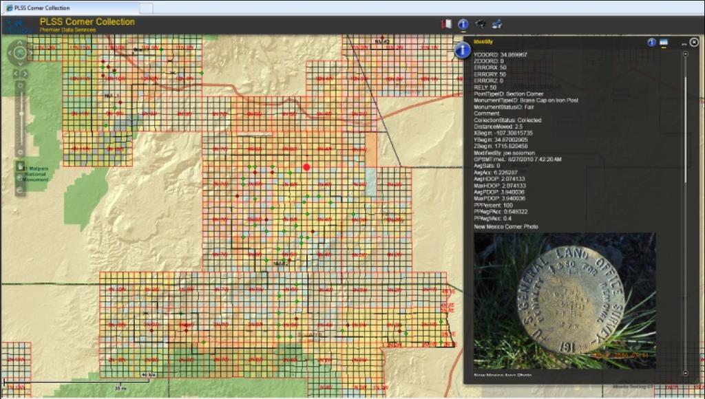
1 Bureau of Land Management MAPPS Federal Update Donald Buhler Cadastral, Lands, and Realty Management April 1, 2014 Division of Cadastral, Lands and Realty Management 1
2 BLM Mission Manages 247 million surface acres 700 million acres of Federal mineral estate Mineral operations and cadastral surveys on 56 million acres of Indian trust lands Dual mission of conservation and traditional land users Key to the vitality of local economies Delivering benefits to all Americans through outdoor recreation, livestock grazing, mineral development and energy production. Division of Cadastral, Lands and Realty Management 2
3 FY 2014 Land Buy-Back Program for Tribal Nations Alaska Conveyance and Lands Geospatial Publication Module Minerals and Lands Records System (MLRS) Division of Cadastral, Lands and Realty Management 3


4 Land Buy back Mapping Process A high level understanding Division of Cadastral, Lands and Realty Management 4
5 Requirements.to meet the specialized needs of federal government appraisers (OVS/OME) to accurately position assets and resources relative to parcel boundaries to determine parcel valuations..using data or information contained in federal databases or other systems and which are derived from official records..data/information to be from an authoritative sources. (TAAMS and the GCDB) Division of Cadastral, Lands and Realty Management 5
6 For what purpose? To reduce the number of fractional interests in trust or restricted lands, using reasonable efforts to prioritize the consolidation of the most highly fractionated tracts of land as required by the Settlement. To maximize the number of tracts in which the tribe gains a controlling ownership interest to unlock land for beneficial use or conservation by tribal nations, taking tribal priorities into account. Division of Cadastral, Lands and Realty Management 6
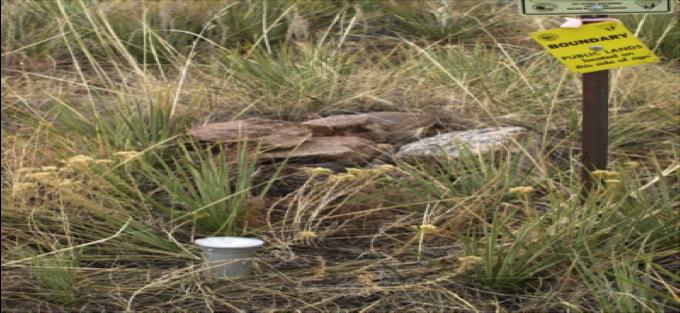
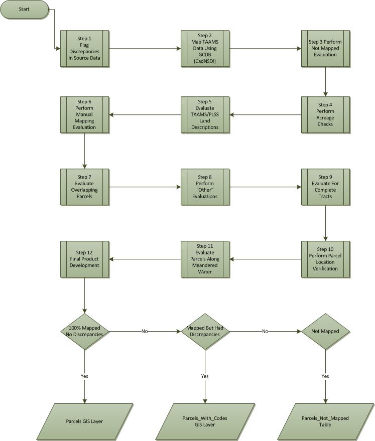
7 Deliverables Parcel Geodatabase (TAAMS) (Initial and final mapping) PLSS Geodatabase (GCDB) (Initial and final mapping) Discrepancy Report (Excel format) (Initial and final mapping) This is an automated function recording where and why congruency between PLSS and TAAMS failed. QA/QC Report Full Documentation of the Mapping Process. Division of Cadastral, Lands and Realty Management 7
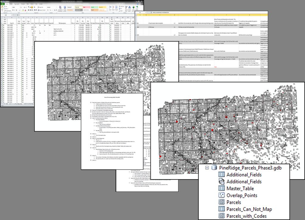

8 Deliverables Division of Cadastral, Lands and Realty Management 8
9 Alaska Land Conveyance Uncertain budgets FY 12 $29 M FY 13 - $16.6 M FY 15 - $19 M (proposed) FY 14 - $22 M 2015 request level plots a course for completing all surveys and land transfers in ten years. Finish the surveys for Alaska Native Corporation land selections and transfers to the Corporations in five years. Complete surveys and transfer for the State of Alaska land selections within ten years. Division of Cadastral, Lands and Realty Management 9
10 Alaska Land Transfer Remaining Workload Summary ANCSA Entitlement 45,764,004 Conveyed To Date 43,831,835 Title Passed by Patent 33,385,397 Title Passed by Interim Conveyance 10,446,438 ANCSA Remaining Entitlement 1,932,169 State Entitlement 104,525,001 Conveyed To Date 99,199,369 Title Passed by Patent 63,644,614 Title Passed by Tentative Approval 35,554,754 State Remaining Entitlement 5,325,632 ANCSA State Remaining Adjudication Workload 12,401,178 40,880,386 Remaining Survey Workload ~3,000,000 ~20,000,000 Division of Cadastral, Lands and Realty Management 10
11 Geospatial Publication Module Replaces the GeoCommunicator Contract Award to URS (Sept. 2013) Corporate way to deliver our data BLM lacks a simple, Google-like viewer for a broad range of users on a broad range of platforms. Customer service in an open environment aligned with the new Open Data Executive Order. Division of Cadastral, Lands and Realty Management 11
12 Solution Requirement Single point of access for both internal users and the public Enable search, visualization, and retrieval of geospatial and spatially-enabled data Coordinate and visualize information in an adaptable, convenient, accessible way Use cost effective, nimble, modern, and versatile technology Division of Cadastral, Lands and Realty Management 12

13 Division of Cadastral, Lands and Realty Management 13
14 Minerals and Lands Records System (MLRS) RFI Extent and status of the Nation s land estate General Land Office (1812) Provide BLM, Federal agency partners, Congress and private-interest stakeholder Legacy Rehost 2000 system (LR2000) Document the rights and interest of the U.S. in the form of electronic documents, images and metadata to include geospatial references Division of Cadastral, Lands and Realty Management 14

15 Division of Cadastral, Lands and Realty Management 15
16 FY 2015 Budget Justification Cadastral, Lands, and Realty Management Consolidation Transmission Corridors Enterprise Geospatial Information System Division of Cadastral, Lands and Realty Management 16
17 Budget Structure and Technical Changes The budget proposes to combine the current Cadastral Survey subactivity and Land and Realty Management subactivity into a new Cadastral, Lands, and Realty Management subactivity. Consolidation allows flexible management at the field level to accomplish BLM s highest priority needs and reflects the complementary nature of the programs and personnel. Division of Cadastral, Lands and Realty Management 17
18 Rights-of-Way Issuance $5.0 million increase in the Cadastral, Lands and Realty Management program to support necessary upgrades for reliability and increased capacity of federal ROWs Identify and designate energy corridors in low conflict areas and site high voltage transmission lines, substations and related infrastructure in an environmentally sensitive manner. This increase complements the Secretary s Powering Our Future initiative. Division of Cadastral, Lands and Realty Management 18
19 Enterprise Geospatial Information System The budget request includes a $3.8 million increase in Resource Management Planning to support implementation of BLM s Enterprise Geospatial Information System (EGIS). The BLM EGIS proposal is integrated within Interior s growing enterprise GIS capabilities and serves as a critical component of the Department s corporate EGIS strategy Division of Cadastral, Lands and Realty Management 19
Bureau of Land Management MAPPS Federal Update Donald Buhler Cadastral, Lands, and Realty Management April 14, 2015
 Bureau of Land Management MAPPS Federal Update Donald Buhler Cadastral, Lands, and Realty Management April 14, 2015 Division of Cadastral, Lands and Realty Management 1 BLM Mission Manages 247 million
Theme Strategic Plan for Cadastral Theme
 Theme Strategic Plan for Cadastral Theme Bureau of Land Management Cadastral Survey Federal Geographic Data Committee (FGDC) 2017 2021 April 2017 - Progress and Update Cadastral Theme Implementation Plan
Cadastral NSDI Reference Document
 Cadastral NSDI Reference Document Version 12 October 2012 FGDC Subcommittee for Cadastral Data Cadastral NSDI Reference Document Table of Contents 1. Purpose... 1 2. Business Applications... 1 3. Terminology
Egyptian Nationwide Title Cadastre System
 Kholoud SAAD, Egypt Key words: Cadastre, Registration, Urban, Rural, National Cadastre, Automation, reengineering. SUMMARY With growing need for integrated information, Enterprise Solutions has become
Installation Boundary Mapping and the DoD Real Property Inventory Program
 Installation Boundary Mapping and the DoD Real Property Inventory Program 11 October 2007 SAME Mid-Atlantic Regional Conference Jeff Swallow Real Property History Real Property data reported to the Office
Cadastral PLSS Stewardship December 2010 Updated December 2013
 Cadastral PLSS Stewardship December 2010 Updated December 2013 Compiled by Bob Ader, Ben Knott, and Nancy von Meyer for the FGDC Cadastral Subcommittee Table of Contents 1. Overview... 2 2. Underlying
National Spatial Data Infrastructure development in Republic of Macedonia
 National Spatial Data Infrastructure development in Republic of Macedonia Sonja Dimova, state advisor for geomatics AGENCY FOR REAL ESTATE CADASTRE September 6-th, 2017, Strasbourg AREC competence for
25 CFR, PART 151 LAND ACQUISITIONS
 25 CFR, PART 151 LAND ACQUISITIONS Contents 151.1 Purpose and scope. 151.2 Definitions. 151.3 Land acquisition policy. 151.4 Acquisitions in trust of lands owned in fee by an Indian. 151.5 Trust acquisitions
Map Modernization Modernization Program
 FEMA Map Modernization Program Presented to Maryland Association of Floodplain and Stormwater Managers October 27, 2005 Map Modernization Program Autorun.exe 2 Map Modernization Program Outline Map Mod
11 Teranet Easement Mapping Data Acquisition
 Clause 11 in Report No. 18 of Committee of the Whole was adopted, without amendment, by the Council of The Regional Municipality of York at its meeting held on November 19, 2015. 11 Teranet Easement Mapping
The Journey to 100% Electronic Survey. Land Information New Zealand. August 2009
 The Journey to 100% Electronic Survey and Title Lodgement Land Information New Zealand August 2009 Land Information New Zealand Established 1996 Titles, Survey, Geodetic, Electoral 12 locations 500 staff
Assessor. Mission Statement: Functions: Long Term Goals: Page 1 of 6
 Assessor Mission Statement: The mission of the Assessor s Office is to create accurate, equitable, and timely property tax assessments to fund public services; and to be a source of current, accurate property
RIGHT-of-WAY in INDIAN COUNTRY
 RIGHT-of-WAY in INDIAN COUNTRY REALTY and the TTP PROGRAM James Brophy FHWA Tribal Transportation Program What is a Right-of-Way? right of way also right-of-way (rtv-w) n. pl. rights of way or right of
Integrating the Enterprise
 Integrating the Enterprise Lora Muchmore, Director, Business Enterprise Integration Office of the Deputy Under Secretary of Defense (Installations and Environment) Session F, Business Transformation May
PREPARING SURVEY TENDER GIS DATABASE OUTCOMES
 PREPARING SURVEY TENDER SPECIFICATIONS FOR PROJECT GIS DATABASE OUTCOMES Presentation by Ian Harper GEODATA AUSTRALIA ESRI User Conference 2009 24 st July 2009 BACKGROUND GIS databases now provide a more
LRIMS Cadastre Module
 LRIMS Cadastre Module User Requirements and Functionality (Seychelles Case Study) John Latham, NRL Renato Cumani, NRL Luigi Simeone, NRL Summary Background User Requirements Business Model Application
Esri Middle East and Africa User Conference. December Abu Dhabi, UAE. Land Administration. Mark Baker
 Esri Middle East and Africa User Conference December 10 12 Abu Dhabi, UAE Land Administration Mark Baker Our Agenda 0900 0930 Welcome Mark Baker, Esri 0930 1030 New Directions The New Addressing System
Participants of the Ministerial Meeting on Housing and Land Management on 8 October 2013 in Geneva
 Summary At its meeting on 2 April 2012, the Bureau of the Committee on Housing and Land Management of the United Nations Economic Commission for Europe agreed on the need for a Strategy for Sustainable
City-Wide Real Estate Transformation
 City-Wide Real Estate Transformation Presentation on Portfolio & Asset Management Toronto Realty Agency Board Meeting October 20, 2017 Re: RA5.3 What is Portfolio Strategy & Asset Management Portfolio
PART ONE - GENERAL INFORMATION
 Corrected Date: Page 7 Date of Submittal Changed to Coincide with Submittal Date on Page 5 PART ONE - GENERAL INFORMATION A. INTRODUCTION B. Background Miami Shores Village is soliciting responses to this
An Overview of the eplan Journey with a Focus on the Victorian eplan 2025 Roadmap Dr Hamed Olfat
 An Overview of the eplan Journey with a Focus on the n eplan 2025 Roadmap Dr Hamed Olfat eplan Coordinator Land Use Chairman of Technical Committee ICSM eplan Working Group Outline eplan Overview ICSM
TREASURER S DEPARTMENT
 TREASURER S DEPARTMENT ORGANIZATIONAL CHART COUNTY TREASURER ADMINISTRATION SERVICE TO PUBLIC SERVICE TO COUNTY DEPARTMENTS SERVICE TO COUNTY GOV T DEPARTMENT DESCRIPTION The Treasurer s Office is a mandated
[RR , 189R5065C6, RX ] National Environmental Policy Act Implementing Procedures for the Bureau of
![[RR , 189R5065C6, RX ] National Environmental Policy Act Implementing Procedures for the Bureau of](/thumbs/95/125373881.jpg "[RR , 189R5065C6, RX ] National Environmental Policy Act Implementing Procedures for the Bureau of") This document is scheduled to be published in the Federal Register on 10/17/2018 and available online at https://federalregister.gov/d/2018-22630, and on govinfo.gov 4332-90-P DEPARTMENT OF THE INTERIOR
This document is scheduled to be published in the Federal Register on 10/17/2018 and available online at https://federalregister.gov/d/2018-22630, and on govinfo.gov 4332-90-P DEPARTMENT OF THE INTERIOR
Digitalisation of the Real Property Rights Towards Spatially enabled E-Government
 Digitalisation of the Real Property Rights Towards Spatially enabled E-Government Lise Schroeder, Bent Hulegaard Jensen, Esben Munk Soerensen & Line Hvingel Istanbul, Turkey 25 june 201 Overview Introduction
CFedS Outline Unit 1. Course 1: History, Records & Administrative Systems
 CFedS Outline Unit 1 Course 1: History, Records & Administrative Systems History of U.S. Surveying Historical Perspective Similarities in Surveying Seniority of Calls Lack of Standards A National Debt
002 - Assessor GENERAL GOVERNMENT SERVICES ASSESSOR Assessor. At a Glance:
 GENERAL GOVERNMENT SERVICES 002 - ASSESSOR Operational Summary Mission: To serve the citizens of Orange County by valuing all legally assessable property with uniformity and impartiality, producing property
PLSS as a Spatial Framework: A History of GCDB Steven L. Hope. Abstract. Background
 PLSS as a Spatial Framework: A History of GCDB Steven L. Hope Abstract The Bureau of Land Management (BLM) initiated the Geographic Coordinate Data Base (GCDB) project to digitally portray the Public Land
PROJECT INFORMATION DOCUMENT (PID) CONCEPT STAGE Report No.: AB3229 Project Name. Land Registry and Cadastre Modernization Project Region
 CONCEPT STAGE Report No.: AB3229 Project Name. Land Registry and Cadastre Modernization Project Region") PROJECT INFORMATION DOCUMENT (PID) CONCEPT STAGE Report No.: AB3229 Project Name Land Registry and Cadastre Modernization Project Region EUROPE AND CENTRAL ASIA Sector Central government administration
PROJECT INFORMATION DOCUMENT (PID) CONCEPT STAGE Report No.: AB3229 Project Name Land Registry and Cadastre Modernization Project Region EUROPE AND CENTRAL ASIA Sector Central government administration
Land Administration and Spatial Enablement Victoria s Experience. Chris McRae, Executive Director Land Victoria
 Land Administration and Spatial Enablement Victoria s Experience Chris McRae, Executive Director Land Victoria 4 th UN Land Administration Forum, October 2011 Outline About Land Victoria Land Victoria
Cadastral Data Content Standard - Rights and Interests
 Background Concepts Rights and Interests - Regulations and Restrictions In the Cadastral Data Content Standard Version 2 - June 30, 2014 A review of the content and background Nancy von Meyer Rights and
[15XL LLIDI02000.L EO0000. LVTFD A ; IDI- Notice of Intent to Amend the Pocatello Resource Management Plan and Notice of
 This document is scheduled to be published in the Federal Register on 08/10/2015 and available online at http://federalregister.gov/a/2015-19606, and on FDsys.gov 4310-GG-P DEPARTMENT OF THE INTERIOR Bureau
Marine Spatial Data Infrastructure (MSDI) & The Marine Cadastre Application. April 10, 2018
 & The Marine Cadastre Application. April 10, 2018") Marine Spatial Data Infrastructure (MSDI) & The Marine Cadastre Application April 10, 2018 A Collaborative Pilot Project Vision of CHS: A framework of geographic data, metadata, users and tools Intent
Marine Spatial Data Infrastructure (MSDI) & The Marine Cadastre Application April 10, 2018 A Collaborative Pilot Project Vision of CHS: A framework of geographic data, metadata, users and tools Intent
GLOBAL GEOSPATIAL MANAGEMENT INFORMATION
 GLOBAL GEOSPATIAL MANAGEMENT INFORMATION SEOUL, KOREA 24 th to 26 th October 2011 COUNTRY REPORT - REPUBLIC OF BOTSWANA 1. INTRODUCTION 1.1. SOCIAL, ECONOMIC AND POLITICAL BACKGROUND Botswana attained
Fee-to-Trust: What To Expect in the Current Administration
 Fee-to-Trust: What To Expect in the Current Administration Tribal Summit Group September Summit Meeting September 20, 2017 Outline History of Fee to Trust Colonial and early US Indian Removal Act Indian
Institutional Arrangements In Geoinformation: Influence of Legal and Policy Issues **
 ADVANCE UNEDITED VERSION UNITED NATIONS E/CONF.103/24 ECONOMIC AND SOCIAL COUNCIL Tenth United Nations Regional Cartographic Conference for the Americas New York, 19-23, August 2013 Item 6 (a) of the provisional
Cadastral NSDI Reference Document July 2006
 Cadastral NSDI Reference Document July 2006 Purpose This document describes the Cadastral NSDI, its components and the public and private business processes that define the content. The Cadastral National
3.23 LANDS AND SPECIAL USES
 3.23 LANDS AND SPECIAL USES Introduction This section addresses those aspects of SJPLC management relating to public land ownership and use. Special Use Permits, rights-of-way (ROW) grants, easements,
DoD American Indian/Alaskan Native Policy: Alaska Implementation Guidance. 11 May 2001
 DoD American Indian/Alaskan Native Policy: Alaska Implementation Guidance 11 May 2001 2 DOD AMERICAN INDIAN AND ALASKA NATIVE (AI/AN) POLICY ALASKA IMPLEMENTATION GUIDANCE I. Purpose: This Guidance is
Forest Service Role CHAPTER 2
 CHAPTER 2 Forest Service Role Implementation of the Management Plan charters a federal presence with an expanded focus beyond traditional Forest Service roles. In addition to administration of the National
GOVERNMENT. Case Study Ville de Trois Rivières streamlines property assessment
 GOVERNMENT Case Study Ville de Trois Rivières streamlines property assessment GIS-generated parcel basemap provides powerful visualization & analysis capabilities With a population of just over 130,000,
FGDC Cadastral Data Subcommittee. December 2008
 FGDC Cadastral Data Subcommittee Annotated Bibliography: Foundational Documents for Building a Cadastral National Prepared by David Stage and Nancy von Meyer for the FGDC Cadastral Data Subcommittee Annotated
New Developments in the Hellenic Cadastre
 New Developments in the Hellenic Cadastre Prof. M. Kavouras Vice-president Ktimatologio S.A. (Hellenic Cadastre) The Hellenic Cadastre Background The Hellenic National Cadastre Organizational and institutional
2018 Assessment Roll Edit Guide for Parcel-Level Geographical Information System (GIS) Information
 Information") 2018 Assessment Roll Edit Guide for Parcel-Level Geographical Information System (GIS) Information Florida Department of Revenue Property Tax Oversight January 2, 2018 Intended Users This edit guide is
2018 Assessment Roll Edit Guide for Parcel-Level Geographical Information System (GIS) Information Florida Department of Revenue Property Tax Oversight January 2, 2018 Intended Users This edit guide is
PROJECT SCORING GUIDANCE. Introduction: National Proiect Selection:
 FOREST LEGACY PROGRAM PROJECT SCORING GUIDANCE Introduction: This document provides guidance to the National Review Panel on how to score individual Forest Legacy Program (FLP) projects, including additional
Directorate of Survey and Mapping NAMIBIA. Cadastral Information System. Vehupisa Kasuko Tjatindi Surveyor Directorate of Survey and Mapping NAMIBIA
 Vehupisa Kasuko Tjatindi Directorate of Survey and Mapping NAMIBIA Tel: +64 61 965000 Directorate of Survey and Mapping NAMIBIA Cadastral Information System Introduction Over the past few decades cadastral
Cloud GIS Real Estate Management, Appraisal and Development Service USING ESRIs ARCGIS SERVER
 Cloud GIS Real Estate Management, Appraisal and Development Service USING ESRIs ARCGIS SERVER INFODIM: Was founded on 1992 and is internationally certified as a GIS company from D&B Dun & Bradstreet Global
Conservancy Mission. Leveraging GIS Technologies in Chesapeake Conservation and Restoration 10/17/2018
 Leveraging GIS Technologies in Chesapeake Conservation and Restoration Rachel Soobitsky Geospatial Project Manager Chesapeake Conservancy Conservation Innovation Center Kristin Kirkwood Executive Director
The United States Mortgage Crisis and Cadastral Data. Donald Buhler, Bureau of Land Management. David Cowen, University of South Carolina
 The United States Mortgage Crisis and Cadastral Data Donald Buhler, Bureau of Land Management David Cowen, University of South Carolina What Have Americans Paid (and Maybe the Rest of the World) for Not
FROM RESIDENTIAL LICENSES TO FULL TITLE IN TANZANIA
 FORMALISATION OF LANDED PROPERTIES IN UNPLANNED SETTLEMENTS FROM RESIDENTIAL LICENSES TO FULL TITLE IN TANZANIA by Sarah A. Kyessi, Assistant Director Settlements Regularisation Ministry of Lands Housing
REQUEST FOR PROPOSAL
 REQUEST FOR PROPOSAL FOR Spokane Tribe of Indians LDR/COS Certificates YEPA Property And Task Order Contract PROPOSAL NO. FY2011/042 BY SPOKANE TRIBE OF INDIANS PURCHASING/PROPERTY DEPARTMENT 6195 FORD/WELLPINIT
TREASURER S DEPARTMENT
 TREASURER S DEPARTMENT ORGANIZATIONAL CHART COUNTY TREASURER ADMINISTRATION SERVICE TO PUBLIC SERVICE TO COUNTY DEPARTMENTS SERVICE TO COUNTY GOV T DEPARTMENT DESCRIPTION The Treasurer s Office is a mandated
The programme is implemented
 Surveying Property valuation and spatial data tools to assist in land restitution by Jaco de Kock, GISCOE Land and tenure reform in the South African government context are beyond talk and have received
Shaping the Cadastral Infrastructure for a Digital Future
 DEPARTMENT OF LANDS PLANNING and the ENVIRONMENT Shaping the Cadastral Infrastructure for a Digital Future Craig Sandy Director Surveys Surveyor General Survey Branch NT Australia Digital Cadastral Databases
A Presentation to the. Wyoming Solid Waste and Recycling Association (WSWRA) 2016 Annual Conference Agenda
 2016 Annual Conference Agenda") A Presentation to the Wyoming Solid Waste and Recycling Association (WSWRA) 2016 Annual Conference Agenda So you want to build a landfill? Then you re gonna need some land The Bureau of Land Management
A Presentation to the Wyoming Solid Waste and Recycling Association (WSWRA) 2016 Annual Conference Agenda So you want to build a landfill? Then you re gonna need some land The Bureau of Land Management
The California. Protected Areas Database (CPAD)
") The California Protected Areas Database (CPAD) Larry Orman, Executive Director November, 2013 Roadmap 1. What are "protected areas"? 2. How CPAD works 3. Uses for CPAD data 4. Easement data 5. Next steps
The California Protected Areas Database (CPAD) Larry Orman, Executive Director November, 2013 Roadmap 1. What are "protected areas"? 2. How CPAD works 3. Uses for CPAD data 4. Easement data 5. Next steps
For the reasons set forth in the preamble, the Department proposes to amend 25 CFR 151
 For the reasons set forth in the preamble, the Department proposes to amend 25 CFR 151 as follows: 1. Revise Part 151 of Title 25 of the Code of Federal Regulations to read as follows: PART 151 LAND ACQUISITION
Key Registers in Finland and some views of Cadastre 2035
 Presented at the FIG Working Week 2016, May 2-6, 2016 in Christchurch, New Zealand Key Registers in Finland and some views of Cadastre 2035 FIG Working Week, Christchurch New Zealand May, the 3rd, 2016
LOW-COST LAND INFORMATION SYSTEM FOR SUSTAINABLE URBAN DEVELOPMENT
 Presented at the FIG Congress 2018, May 6-11, 2018 in Istanbul, Turkey LOW-COST LAND INFORMATION SYSTEM FOR SUSTAINABLE URBAN DEVELOPMENT Case Examples in Kenya and Zambia Presented by John Gitau Land
Nevada Public Land Management Task Force Final Report, SJR 1 of the 78 th Nevada Legislature and Implementation through Federal Legislation
 Nevada Public Land Management Task Force Final Report, SJR 1 of the 78 th Nevada Legislature and Implementation through Federal Legislation Churchill County Public Meeting Churchill County Commission Chamber
Lake County Planning & Community Development
 Lake County Planning & Community Development Pre-Application Meeting for CDBG/HOME Programs Lake County Board of Commissioners Robert E. Aufuldish Judy Moran Daniel P. Troy Welcome & Introductions For
The Multipurpose Marine Cadastre A Tool for Planning & Decision Making in the Marine Environment
 The Multipurpose Marine Cadastre A Tool for Planning & Decision Making in the Marine Environment Christine Taylor Minerals Management Service (MMS) Brian Smith NOAA Coastal Services Center Maurice Hill
Notice of Realty Action: Recreation and Public Purposes Act Classification and. Lease/Conveyance of Public Land, La Plata County, CO
 This document is scheduled to be published in the Federal Register on 09/18/2013 and available online at http://federalregister.gov/a/2013-22662, and on FDsys.gov 4310-JB DEPARTMENT OF THE INTERIOR Bureau
) ) ) ) ) ) (Issued September )
 ) ) ) ) ) (Issued September )") BEFORE THE PUBLIC SERVICE COMMISSION OF WYOMING IN THE MATTER OF THE APPLICATION OF ROCKY MOUNTAIN POWER FOR A CERTIFICATE OF PUBLIC CONVENIENCE AND NECESSITY TO CONSTRUCT THE ARROWHEAD SUBSTATION AND
BEFORE THE PUBLIC SERVICE COMMISSION OF WYOMING IN THE MATTER OF THE APPLICATION OF ROCKY MOUNTAIN POWER FOR A CERTIFICATE OF PUBLIC CONVENIENCE AND NECESSITY TO CONSTRUCT THE ARROWHEAD SUBSTATION AND
Good Land Governance for the 2030 Agenda
 Good Land Governance for the 2030 Agenda Addis Ababa, Ethiopia 20-22 April, 2014 Role of Geospatial Information in Good Land Policy and Governance Oumar Sylla UN-Habitat/GLTN oumar.sylla@unhabitat.org
TOWARDS E-LAND ADMINISTRATION - ELECTRONIC PLANS OF SUBDIVISIONS IN VICTORIA
 TOWARDS E-LAND ADMINISTRATION - ELECTRONIC PLANS OF SUBDIVISIONS IN VICTORIA Mohsen Kalantari 1, Chris Lester 2, David R Boyle 3, Neil Coupar 4 1 eplan Coordinator 2 SPEAR Manager 3 Deputy Surveyor General
Mission Planning for a GPS Control Survey Using ESRI ArcMap. August 8, 2004 Mickie Warwick, PLS
 Mission Planning for a GPS Control Survey Using ESRI ArcMap August 8, 2004 Mickie Warwick, PLS Using ArcMap for GPS Mission Planning Surveyors are not tapping into the benefits that can be derived from
GIS and Land Records Integration A PRIA White Paper
 110 Horizon Drive, Suite 210, Raleigh, NC 27615 919.459.2081 GIS and Land Records Integration A PRIA White Paper Adopted by the PRIA Board on December 20, 2017 www.pria.us/ GIS and Land Records Integration
COUNTY GOVERNMENT OF LAMU Department of Land, Physical Planning, Infrastructure & Urban Development
 1 COUNTY GOVERNMENT OF LAMU Department of Land, Physical Planning, Infrastructure & Urban Development TERMS OF REFERENCE FOR OUTSOURCING OF CONSULTANCY SERVICES FOR SURVEY & REGULARIZATION OF KATSAIKAIKAIRU
NEW MEXICO STATE LAND OFFICE LIMS PROJECT RFP # Functional Requirements Matrix
 NEW EXICO STATE LAND OFFICE LIS PROJECT RFP # 30-539-13-00178 Functional Requirements atrix Once the LIS project is complete the systems of record will be as follows: LIS Land Grid; e.g. PLSS subdivision
ERER Pilot Measurements County & Trusted Submitter
 ERER Pilot Measurements County & Trusted Submitter ERER Task Force Consideration 1. Cost / Benefit - Consider studying existing system configurations, hardware types, outsourcing practices, and vendor
A CADASTRAL GEODATA BASE FOR LAND ADMINISTRATION USING ARCGIS CADASTRAL FABRIC MODEL A CASE STUDY OF UWANI ENUGU, ENUGU STATE, NIGERIA
 A CADASTRAL GEODATA BASE FOR LAND ADMINISTRATION USING ARCGIS CADASTRAL FABRIC MODEL A CASE STUDY OF UWANI ENUGU, ENUGU STATE, NIGERIA BY Ndukwu, Raphael. Ike Department of Geoinformatics & Surveying University
RAINS COUNTY APPRAISAL DISTRICT
 RAINS COUNTY APPRAISAL DISTRICT 2017 MASS APPRAISAL SUMMARY REPORT mass appraisal report 2017 uspap_appr_report RAINS COUNTY APPRAISAL DISTRICT 2017 MASS APPRAISAL SUMMARY REPORT Identification of Subject:
BULGARIAN CADASTRE A GUARANTEE FOR THE OWNERSHIP RIGHTS IN IMMOVABLE PROPERTIES
 4 TH INTERNATIONAL CONFERENCE RECENT PROBLEMS IN GEODESY AND RELATED FIELDS WITH INTERNATIONAL IMPORTANCE February 28 - March 2, 2007, Inter Expo Centre, Sofia, Bulgaria BULGARIAN CADASTRE A GUARANTEE
Iranian Cadastre System. Nasrollah Jahangard Iran s Deeds and Properties Registration Organization I.R. of Iran 14 th PCGIAP, KL, Malaysia 2008
 Iranian Cadastre System Nasrollah Jahangard Iran s Deeds and Properties Registration Organization I.R. of Iran 14 th PCGIAP, KL, Malaysia 2008 General Information Europe Middle East Asia Africa Middle
PAD-US (CBI Edition) Version 2. Metadata: Metadata also available as
 Version 2. Metadata: Metadata also available as") PAD-US (CBI Edition) Version 2 Metadata also available as Metadata: Identification_Information Data_Quality_Information Spatial_Data_Organization_Information Spatial_Reference_Information Entity_and_Attribute_Information
PAD-US (CBI Edition) Version 2 Metadata also available as Metadata: Identification_Information Data_Quality_Information Spatial_Data_Organization_Information Spatial_Reference_Information Entity_and_Attribute_Information
Christian C. Sizemore, Land Lead Newfield Exploration Company
 Christian C. Sizemore, Land Lead Newfield Exploration Company You could say that I grew up with oil and gas in my blood. I am the son of a lifelong landman, born and raised in Billings, Montana. After
Land Information System as new instrument for Land Administration: Case Examples. Mike Cheremshynskyi Consultant, Land Administration Expert
 Land Information System as new instrument for Land Administration: Case Examples Mike Cheremshynskyi Consultant, Land Administration Expert Background Growth of population and fast urbanization in many
Public Facilities and Finance Element
 This Element of the General Plan addresses the following public facilities issues: Water Service, including both potable (drinkable) and non-potable water delivery. Sewer Service, and Financing and construction
Greetings from Denmark. Property Rights, Restrictions and Responsibilities - A Global Land Management Perspective. Wonderful Copenhagen
 Property Rights, Restrictions and Responsibilities - A Global Land Management Perspective Greetings from Denmark 43,000 sq km Prof. Stig Enemark President Aalborg University, Denmark Aalborg Copenhagen
Building Integrated Land Information Systems and Development of NSDI
 Stig JÖNSSON, Sweden Key words: Land administration, land information systems, property formation, spatial data infrastructure, Inspire, institutional cooperation SUMMARY Lantmäteriet the Swedish agency
The Development Strategy for Cadastre and Land Register in Finland
 1 2 The Development Strategy for and Land in Finland Arvo Kokkonen Ministry of Agriculture and Forestry Facts and figures of Finland - land area 304 530 km² - water area 33 615 km² - total area 338 195
First Nations Land Registry
 First Nations Land Registry Making Sense of the ILRS Steven Patterson, Sitka Geomatics Inc. www.sitkageo.com Land Titles a brief history Land titles were traditionally managed within the community, and
Challenges for the multi purpose cadastre
 Jens RIECKEN, Markus SEIFERT, Germany Key words: Multi purpose cadastre, 3d-cadastre, land use, SDI, solar cadastre SUMMARY Over the past 30 years, with the progress of information technologies the development
Scenic Nepal. Land Administration Systems. Outline of Presentation. Interests in land. Rights: Registration and security of tenure positions
 Scenic Nepal Land Administration Systems Managing Rights, Restrictions, and Responsibilities in Land Prof. Stig Enemark President Aalborg University, Denmark SURVEY DEPARTMENT KATHMANDU, NEPAL. 16 FEBRUARY
Concerns about Methodology
 1979 NDSPLS ADMINISTRATIVE OFFICE PO Box 7370 Bismarck, ND 58507 Phone: 701-223-3184 E-mail: info@ndspls.org Website: www.ndspls.org North Dakota Industrial Commission Department of Mineral Resources Lynn
CATALOGING, MONITORING AND MANAGING INVASIVE SPECIES ON POST LANDS. PSU Geog596A Capstone Proposal Dale Jantzen Dec 17, 2015
 CATALOGING, MONITORING AND MANAGING INVASIVE SPECIES ON POST LANDS PSU Geog596A Capstone Proposal Dale Jantzen Dec 17, 2015 PROJECT OUTLINE AND PURPOSE Define a particular need within a non-profit land
The Cadastral Modelling Future and The Land Surveyors Role
 The Cadastral Modelling Future and The Land Surveyors Role Ian Harper Geodata Australia ESRI Survey Summit July 2013 The Land Surveyors Future Role From Custodians of the Cadastre to Custodians of the
ArcCadastre Implementations within the Middle East
 ArcCadastre Implementations within the Middle East Kholoud Saad SALAMA, Egypt Key words: Cadastre, GIS, Survey, Data Conversion, Workflow SUMMARY In recent years, cadastre systems have developed from manual
CADASTRE 2014: New Challenges and Direction
 CADASTRE 2014: New Challenges and Direction Anna KRELLE and Abbas RAJABIFARD, Australia Key words: Cadastre, Cadastre 2014, Land Administration SUMMARY Land and land related activities form part of the
GIS Based Tools for County Road Management Right-of-Way Land Value Analysis. January 12, 2012
 GIS Based Tools for County Road Management Right-of-Way Land Value Analysis January 12, 2012 Reasons for Needing Accurate Land Values Asset Management 1999 GASB Statement 34 Corridor Studies Scoping Studies
to NMSA 1978 Updated 2013 ARTICLE 6 Sale of Public Property Section Disposition of obsolete, worn out or
 ARTICLE 6 Sale of Public Property Section 13 6 1 Disposition of obsolete, worn out or unusable tangible personal property. 13 6 2 Sale of property by state agencies or local public bodies; authority to
A signal in association with technology carried by electrical, digital, magnetic, wireless, optical, electromagnetic, or similar capabilities.
 DEFINITIONS Bonded Asset: A registered land asset wherein the issuer guarantees the performance of registered land asset contract terms directly and/or through an insurance policy, which guarantees the
Remains eligible for state or federal farm programs. Can use land as collateral for loans. Can reserve home lots for children
 December 2002 B-1132 Conservation Easements: An Introductory Review for Wyoming By Allison Perrigo and Jon Iversen, William D. Ruckelshaus Institute of Environment and Natural Resources William D. Ruckelshaus
Cadastre and Land Registration in Europe
 Annex A: Questionnaire 2007 for Information Resource Cadastre and Land Registration in Europe Introduction This questionnaire is based on the EuroGeographics vision document 'Cadastre and Land Registration
City of Philadelphia POLICIES FOR THE SALE AND REUSE OF CITY OWNED PROPERTY. Approved By Philadelphia City Council on December 11, 2014
 City of Philadelphia POLICIES FOR THE SALE AND REUSE OF CITY OWNED PROPERTY Approved By Philadelphia City Council on December 11, 2014 City of Philadelphia Disposition Policies December 2014 1 Table of
New Technology for Cadastral Systems. Brent Jones, PE, PLS
 New Technology for Cadastral Systems Brent Jones, PE, PLS Benefits of Good Land Administration Key to addressing global challenges.. Secure Tenure Equitable Land and Property Taxation Support for Government
NATIONAL PLANNING AUTHORITY. The Role of Surveyors in Achieving Uganda Vision 2040
 NATIONAL PLANNING AUTHORITY The Role of Surveyors in Achieving Uganda Vision 2040 Key Note Address By Dr. Joseph Muvawala Executive Director National Planning Authority At the Annual General Meeting and
MAKING THE MOST EFFECTIVE AND SUSTAINABLE USE OF LAND
 165 SOC146 To deliver places that are more sustainable, development will make the most effective and sustainable use of land, focusing on: Housing density Reusing previously developed land Bringing empty
Chapter 3: A Framework for a National Land Information Infrastructure
 Chapter 3: A Framework for a National Land Information Infrastructure Brian Marwick Overview As a federated county, Australia s land administration systems are state and territory based. These systems,
What s Next for Commercial Real Estate Leveraging Technology and Local Analytics to Grow Your Commercial Real Estate Business
 What s Next for Commercial Real Estate Leveraging Technology and Local Analytics to Grow Your Commercial Real Estate Business - A PUBLICATION OF GROWTH MAPS- TABLE OF CONTENTS Intro 1 2 What Does Local