Developing Infrastructure Framework To Facilitate The Malaysia Multipurpose 3D Cadastre
|
|
|
- Gervais McDonald
- 5 years ago
- Views:
Transcription
1 Developing Infrastructure Framework To Facilitate The Malaysia Multipurpose 3D Cadastre Sr Dr. Tan Liat Choon Sr Looi Kam Seng University of Technology Malaysia Department of Survey and mapping Malaysia Commission No. 7 Outline INTRODUCTION 3D CADASTRE MALAYSIAN LAND ADMINISTRATION National Digital Cadastral Database (NDCDB)-eKADASTER etanah MULTIPURPOSE CADASTRE EMPIRICAL CASE STUDY PROPOSED MALAYSIAN LAND ADMINISTRATION DOMAIN MODEL RECOMMENDATIONS FOR AMENDMENTS TO NATIONAL LAND CODE 1965 TOWARDS DATA INFORMATION INTEGRATION CONCLUSION


2 INTRODUCTION Land Administration Land Registration Legal and Multipurpose Cadastre The processes of determining, recording and disseminating information about the tenure, value and use of land when implementing land management policies Cadastral Surveying and Mapping Land Information Systems
3 Land Administration Juridical Fiscal Multipurpose CADASTRE 3D CADASTRE
4 Constraints In 2D Cadastre (Legal Aspect) Situations have emerged where the dimensions aboveand belowthe ground surface, besides those on the ground, are important considerations in property ownership. 2D cadastre assumes the earth as flat which is unable to represent the real world, especially overlappingand interlockingmix development. The existence of overlapping and interlocking constructions called for the ability to establish multilevel ownership. National Land Code 1965 The National Land Code 1965 only allows 3 types of lot/parcel, i.e.: Land Strata Parcel and Land Parcel in strata Scheme Stratum The more efficient of cadastre system in future is to allow 3D lot/parcel including air space and marine space.


5 TheReal World Is 3D But Cadastre Is Not 3D Space Conceptual Diagram Marine Space Conceptual Diagram

6 MALAYSIAN LAND ADMINISTRATION Federal Department of Survey and Mapping Land Office Cadastral Survey State Torrens System etanah ekadaster Land & Mines Office
7 National Digital Cadastral Database (NDCDB) NDCDB Based on a uniform coordinate system, i.e. GDM2000 Cassini Soldner system. Uniform spatial accuracy of about < 10 cm throughout Peninsular Malaysia. Cadastral database and system that is compatible with GIS technology and GPS MyRTKnet system.
8 G002 G084 P4 G014 P075 Old And New Geodetic Infrastructure GEODETIC TRIANGULATION PENINSULAR MALAYSIA 6.50 G058 G071 G028 G035 G023 G G057 G040 G047 G031 G030 G044 G054 G003 G025 G032 G033 G077 G G059 G076 G021 G019 G017 G063 G048 G026 G013 G050 G027 G060 G069 G053 G072 G008 G G024 G022 G037 G034 G005 G G G041 G G001 G074 G075 G070 G061 G073 G009 G036 G011 G G052 G055G065 G068 G038 G020 G066 G012 G G051 G010 G G049 G G043 G045 G056 G018 G MULTIPURPOSE CADASTRE


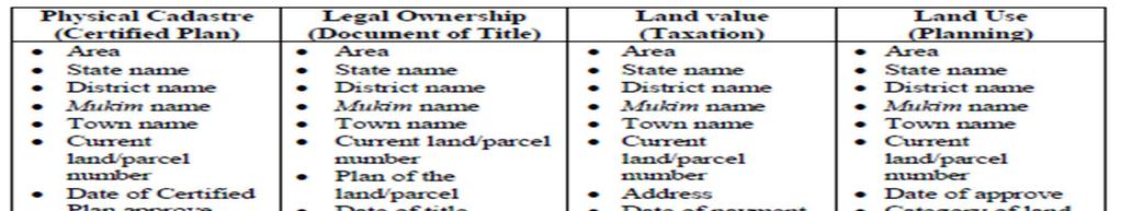
9 Multipurpose Cadastre Components NDCDB LARGE SCALE GEOSPATIAL DATA NON- SPATIAL DATA MPC Valuation Ownership Geonames Land value Land use EMPIRICAL CASE STUDY
10 Introduction Existing NDCDB database adopted is in 2D (x, y). The purpose of this paper is to examine the possibility of implementing 3D cadastre system in Malaysia, i.e. 3D (x, y, h) for each boundaries mark. One of the important principles in the development of cadastral system is the fully 3D information of land surface. Matters to be Addressed a) Field Data Acquisition and adjustment calculation of observed data. Field data collection to produce 3D coordinates in ekadaster and MyGEOID using Digital Field Book interface with LSA, i.e. bearing, distance and height. b) Changes of survey procedures, output structure format, adjustment methodology, NDCDB structure and ekadaster application.
---------- C 1 50924.413-15174.944 98.351!!! C 2 50853.333-15128.287 97.413!!! C 13 50616.")


11 Digital Field Book-3D Output Least Square Adjustment(LSA) Heavily Fixed ecrm East, North & Orthometric Height (MyGeoid) C !!! C !!! C !!! Boundary Lines B * 15 D * 0.01 B * 15 D * 0.01 B * 15 D * 0.01 B * 15 D * Manually Input Vertical Distance HI & HT commented for remarks V /1.57 V /1.57 B D V /1.56 V /1.57 B D


12 PROPOSED MALAYSIAN LAND ADMINISTRATION DOMAIN MODEL Spatial Data Modelling for MY_Lot2D and MY_Lot3D (Malaysian LADM Country Congress, Profile-Joint Kuala Lumpur, Malaysia, research JUPEM and UTM, 2013)

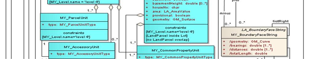


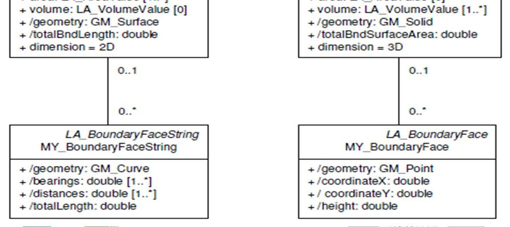
13 Proposed MY_BoundaryFace
14 RECOMMENDATIONS FOR AMENDMENTS TO NATIONAL LAND CODE 1965 Proposed Interpretation On Alienation Of State Land State lands which are alienated or otherwise disposed of, or in respect of which a lease or license to occupy is issued, under this Act may be alienated, leased or licensed- As a parcel of the surface earth, all substances thereunder and so much of the column of airspace abovethe surface as is reasonably necessary for the use and enjoyment thereof; As a parcel of airspace or underground space or marine space whether or not held apart from the surface of the earth; and Only down to such depth below the surface earth or to such a height above the surface earth as the State Authority may by order direct.
15 National Land Code 1965 Basic Legislation Further explain on the definition of land Further explain on alienation of 3D lot Further explain on right to access and right to support Recognise access established through easement National Land Code 1965 Proposed Amendment of section 5 NLC: Land includes: a) The surface (including air space) of the earth and all substances forming that surface; b) The earth below the surface and all substances in the surface; c) All vegetations and other natural products, whether or not requiring the periodical application of labour to their production, and whether on or below the surface; d) All things attached to the earth or permanently fastened to anything attached to the earth, whether on or below the surface; e) Land covered by water; and f) Airspace or marine space whether or not held apart from the surface of the earth.
16 National Land Code 1965 Proposed Amendment of section 396(1)(b): Its boundaries as so determined have been demarcated on the surface of the land, below surface of the land, air space and marine spaceby boundary marks or, if by reason of the configuration thereof or for any other cause the placing of boundary marks on the actual line of the boundary is to any extent impossible or impracticable, boundary marks have been so placed as to enable that line to be ascertained Proposed Amendment of section 396(1)(c): The area and volume enclosed by its boundaries as so determined has been calculated TOWARDS DATA INFORMATION INTEGRATION
17 Data Integration Data Integration
18 CONCLUSION Conclusion The current Malaysian NDCDB and land legislation do not provide 3D information and do not allow registration rights for overlapping properties except underground land respectively. It is believe that the ekadasterand etanahwill make a paradigm shift and able to improve the current land title registration and cadastral survey practice. Malaysia cadastre and land administration systems should be transform to enable multipurpose cadastre, 3D cadastre, marine cadastre and LADM (Homogeneous Cadastre).
19 Acknowledgment Financial assistance from Malaysian Land Surveyors Board (LJT). University of Technology Malaysia Department of Survey and Mapping Malaysia (JUPEM). Thank you for your attention! University of Technology Malaysia, Department of Survey and Mapping Malaysia
CADASTRE SURVEY PRACTICE (SGHU 4323)
") CADASTRE SURVEY PRACTICE (SGHU 4323) WEEK 11-eCADASTRE SR DR. TAN LIAT CHOON 07-5530844 016-4975551 1 OUTLINE Coordinated Cadastral System National Digital Cadastral Database Multipurpose Cadastre 3D Cadastre
CADASTRE SURVEY PRACTICE (SGHU 4323) WEEK 11-eCADASTRE SR DR. TAN LIAT CHOON 07-5530844 016-4975551 1 OUTLINE Coordinated Cadastral System National Digital Cadastral Database Multipurpose Cadastre 3D Cadastre
Developing Infrastructure Framework to Facilitate the Malaysian Multipurpose 3D Cadastre
 Developing Infrastructure Framework to Facilitate the Malaysian Multipurpose 3D Cadastre TAN Liat Choon and LOOI Kam Seng, Malaysia Key words: land administration, land information, multipurpose 3D cadastre,
COURSE OUTLINE. Department of Geoinformation Faculty of Geoinformation and Real Estate. of 6
 1 Lecturer : Sr Dr. Tan Liat Choon Rome No. : C03-312-A Tel. No. : 07-5530844, 016-4975551, web:http://fght.utm.my/tlchoon Email : tlchoon@utm.my; tanliatchoon@gmail.com Synopsis : The main objective of
CHAPTER 8 CONCLUSION
 230 CHAPTER 8 CONCLUSION 8.1 Introduction Based on the empirical study and the analysis from Chapter 6 and Chapter 7 respectively, the concept of multipurpose 3D cadastre for 3D property rights in Malaysia
INTERNATIONAL JOURNAL OF GEOMATICS AND GEOSCIENCES Volume 2, No 2, 2011
 INTERNATIONAL JOURNAL OF GEOMATICS AND GEOSCIENCES Volume 2, No 2, 2011 Copyright 2010 All rights reserved Integrated Publishing services Case study ISSN 0976 4380 Property formation-change in land related
METHODOLOGY FOR THE DEVELOPMENT OF NATIONAL DIGITAL CADASTRAL DATABASE (NDCDB)
") KURSUS COORDINATED CADASTRAL SYSTEM (CCS) INSTITUT TANAH & UKUR NEGARA BEHRANG, PERAK METHODOLOGY FOR THE DEVELOPMENT OF NATIONAL DIGITAL CADASTRAL DATABASE (NDCDB) OLEH: PROF DR ABD MAJID BIN A KADIR
KURSUS COORDINATED CADASTRAL SYSTEM (CCS) INSTITUT TANAH & UKUR NEGARA BEHRANG, PERAK METHODOLOGY FOR THE DEVELOPMENT OF NATIONAL DIGITAL CADASTRAL DATABASE (NDCDB) OLEH: PROF DR ABD MAJID BIN A KADIR
15 LEGAL AND ORGANIZATIONAL ASPECTS OF MALAYSIAN 3D CADASTRE
 15 LEGAL AND ORGANIZATIONAL ASPECTS OF MALAYSIAN 3D CADASTRE Muhammad Imzan Hassan Alias Abdul Rahman Department of Geoinformatics, Faculty of Geoinformation Science and Engineering, Universiti Teknologi
SCOPE OF PRESENTATION
 INTERNATIONAL SYMPOSIUM AND EXHIBITION ON GEOINFORMATION Global Trends: Geoinformation For The New Economy Studies Toward the Development of Implementation Plan Of Coordinated Cadastral System for Peninsular
CADASTRAL STUDIES (MGU1014 / MGHU1514)
") CADASTRAL STUDIES (MGU1014 / MGHU1514) WEEK 10-eCADASTRE SYSTEM AND MULTIPURPOSE CADASTRE SR DR. TAN LIAT CHOON 07-5530844 016-4975551 1 OUTLINE ecadastre System Multipurpose Cadastre 2 ecadastre SYSTEM
CADASTRAL STUDIES (MGU1014 / MGHU1514) WEEK 10-eCADASTRE SYSTEM AND MULTIPURPOSE CADASTRE SR DR. TAN LIAT CHOON 07-5530844 016-4975551 1 OUTLINE ecadastre System Multipurpose Cadastre 2 ecadastre SYSTEM
Development of 3D Cadastre in Hungary
 Development of 3D Cadastre in Hungary András OSSKÓ Gyula IVÁN CLGE General Assembly 22 March 2013, Budapest, HUNGARY Content Introduction Problems in development of 3D cadastre and registration Hungarian
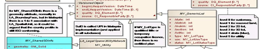
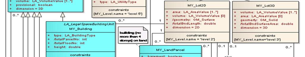
3D Strata Objects Registration for Malaysia within the LADM Framework
 Nur Amalina ZULKIFLI, Alias ABDUL RAHMAN, Malaysia and Peter VAN OOSTEROM, the Netherlands Key words: Strata Registration, Modelling, LADM SUMMARY This paper discusses 3D objects registration and modelling
CADASTRAL STUDIES (MGU1014 / MGHU1514)
") CADASTRAL STUDIES (MGU1014 / MGHU1514) WEEK 8-LAW AND REGULATIONS (FIELD) SR DR. TAN LIAT CHOON 07-5530844 016-4975551 1 OUTLINE Field Survey Practice 2 FIELD SURVEY PRACTICE 3 Survey Datum For new survey
CADASTRAL STUDIES (MGU1014 / MGHU1514) WEEK 8-LAW AND REGULATIONS (FIELD) SR DR. TAN LIAT CHOON 07-5530844 016-4975551 1 OUTLINE Field Survey Practice 2 FIELD SURVEY PRACTICE 3 Survey Datum For new survey
PROPOSED LEGISLATION FOR 3D CADASTRE IN MALAYSIA
 PROPOSED LEGISLATION FOR 3D CADASTRE IN MALAYSIA CHAN Keat Lim, TENG Chee Hua, DAVID LOO Kean Beng Key words: Stratum, Spatium, 2D and 3D cadastre, volumetric lot SUMMARY Malaysia is fortunate to be acknowledged
The Challenge to Implement International Cadastral Models Case Finland 1
 The Challenge to Implement International Cadastral Models Case Finland 1 Tarja MYLLYMÄKI and Tarja PYKÄLÄ, Finland Key words: cadastre, modelling, LADM, INSPIRE SUMMARY Efforts are currently made to develop
Legal Aspects of 3D Property Rights, Restrictions and Responsibilities in Greece and Cyprus
 Legal Aspects of 3D Property Rights, Restrictions and Responsibilities in Greece and Cyprus Efi DIMOPOULOU, National Technical University of Athens, Greece and Elikkos ELIA, Cyprus Department of Lands
PRESENTATION SUMMARY
 COORDINATED CADASTRAL SYSTEM FOR PENINSULAR MALAYSIA: FROM CONCEPT TO REALITY by: Professor Dr. Abd. Majid A. Kadir Associate Professor Ghazali Desa PMP Dr. Abdullah Hisam Omar Faculty of Geoinformation
Key Registers in Finland and some views of Cadastre 2035
 Presented at the FIG Working Week 2016, May 2-6, 2016 in Christchurch, New Zealand Key Registers in Finland and some views of Cadastre 2035 FIG Working Week, Christchurch New Zealand May, the 3rd, 2016
Pacific Rim Real Estate Society (PRRES) Conference 2000
 Conference 2000") Pacific Rim Real Estate Society (PRRES) Conference 2000 Sydney, 23 27 January 2000 THE DEVELOPMENT AND ADMINISTRATIVE ISSUES OF STRATUM TITLE FOR UNDERGROUND LAND RESOURCES IN MALAYSIA MEGAT MOHD. GHAZALI*
Pacific Rim Real Estate Society (PRRES) Conference 2000 Sydney, 23 27 January 2000 THE DEVELOPMENT AND ADMINISTRATIVE ISSUES OF STRATUM TITLE FOR UNDERGROUND LAND RESOURCES IN MALAYSIA MEGAT MOHD. GHAZALI*
CHAPTER 7 ANALYSIS AND DISCUSSION
 195 CHAPTER 7 ANALYSIS AND DISCUSSION 7.1 Introduction The chosen structure in this thesis to compare the differences in Malaysia and Sweden with regard to the development of multipurpose 3D cadastre for
Towards Kenya s Profile of the Land Administration Domain Model
 Department of Geospatial and Space Technology University of Nairobi Towards Kenya s Profile of the Land Administration Domain Model David N. Siriba and Jasper N. Mwenda dnsiriba, jnmwenda{@uonbi.ac.ke}
Malaysian 3D Property Legislation: A Preliminary Approach
 Malaysian 3D Property Legislation: A Preliminary Approach TAN Liat Choon 1, Dr. Khadijah Binti HUSSIN 1, Sr. ERNEST KHOO Hock Oon 2 1 Department of Land Administration and Development, Faculty of Geoinformation
EKADASTER: A LEARNING EXPERIENCE FOR MALAYSIA
 EKADASTER: A LEARNING EXPERIENCE FOR MALAYSIA Mohd Yunus MOHD YUSOFF, Hasan JAMIL, Nur Zurairah ABDUL HALIM, Nor Ashikin MOHAMED YUSOF and Mohammad Azmi MOHD ZAIN, Malaysia Keywords: ekadaster, Cadastral
CURRENT TREND IN GEOINFORMATION TECHNOLOGY INTRODUCTION
 CURRENT TREND IN GEOINFORMATION TECHNOLOGY STUDIES TOWARD THE DEVELOPMENT OF IMPLEMENTATION PLAN OF COORDINATED CADASTRAL SYSTEM FOR MALAYSIA Abd. Majid A. Kadir, Shahrum Ses, Ghazali Desa, Kamalludin
Country report, HUNGARY
 Country report, HUNGARY Gyula IVÁN Institute of Geodesy, Cartography & Remote Sensing (FÖMI) HUNGARY FIG Commission 7 Annual Meeting 2009 12-16 October, 2009, Kuala Lumpur, Malaysia Institute of Geodesy,
THINKING OUTSIDE THE TRIANGLE TAKING ADVANTAGE OF MODERN LAND MARKETS. Ian Williamson
 THINKING OUTSIDE THE TRIANGLE TAKING ADVANTAGE OF MODERN LAND MARKETS Ian Williamson Professor of Surveying and Land Information Head, Department of Geomatics Director, Centre for Spatial Data Infrastructures
LADM-based Crowdsourced 3D Cadastral Surveying Potential and Perspectives
 National Technical University Of Athens School of Rural and Surveying Engineering LADM-based Crowdsourced 3D Cadastral Surveying Potential and Perspectives Maria Gkeli, Surveying Engineer, PhD student
The Boundary and the Effects of Cadastral Surveying in Cyprus
 The Boundary and the Effects of Cadastral Surveying in Cyprus Aristi Louca, Margarita Fani Surveyor Engineers, Cyprus Association of Rural and Surveying Engineers The History of Cyprus goes back 11000
Topographic Signs Important Context of 3D Cadastre
 STATE GEODETIC ADMINISTRATION Gruška 20,10 000 Zagreb, Croatia Delft University of Technology Faculty of Architecture and the Built Environment Department OTB GIS Technology Section Topographic Signs Important
Malaysian Integrated 3D Cadastre
 Malaysian Integrated 3D Cadastre Muhammad Imzan HASSAN and Alias ABDUL RAHMAN, Malaysia Key words: 3D Cadastre, 3D Database SUMMARY The establishment of Malaysia cadastral system is to monitor matters
The Digital Cadastral Database and the Role of the Private Licensed Surveyors in Denmark
 IRISH INSTITUTE OF SURVEYORS, DUBLIN INSTITUTE OF TECHNOLOGY, 23 NOVEMBER 2005 PUBLISHED IN IIS NEWS, WINTHER 2006. The Digital Cadastral Database and the Role of the Private Licensed Surveyors in Denmark
THE XXV FIG INTERNATIONAL CONGRESS IN MALAYSIA Kuala Lumpur, Malaysia, June 2014 at Kuala Lumpur Convention Centre
 CALL FOR PAPERS TO THE XXV FIG INTERNATIONAL CONGRESS IN MALAYSIA Kuala Lumpur, Malaysia, 16 21 June 2014 at Kuala Lumpur Convention Centre Dear Friend and Colleague, It is our privilege and honour to
LAND CADASTRE Today and Challanges for the future Damjan DOLER
 LAND CADASTRE Today and Challanges for the future Damjan DOLER Head of Real Estate Department Regional surveying office Celje Mariborska cesta 88, Celje, SLOVENIA 32nd Conference of Surveyin Authorities,
3D Property Situation in Malaysia-Initiatives towards 3D Cadastre
 3D Property Situation in Malaysia-Initiatives towards 3D Cadastre, Malaysia Key words: land administration, 3D, legislation, cadastre, property SUMMARY Malaysian land administration provides a variety
LADM Implementation Prototype for 3D Cadastre Information System of Multi-Level Apartment in Indonesia
 LADM Implementation Prototype for 3D Cadastre Information System of Multi-Level Apartment in Indonesia Yanto Budisusanto Trias Aditya Rochmad Muryamto IDEA Limitations of land supply for infrastructure
Support to Implementation of Multipurpose Cadastral Information system in Vietnam
 Support to Implementation of Multipurpose Cadastral Information system in Vietnam Lennart JOHANSSON and Per SÖRBOM, Sweden Key words: Land Registration, Land Information, Land Administration, SWOT analyse,
NEW CADASTRAL APPROACH FOR SUSTAINABLE DEVELOPMENT IN MULTILAYER BUILDING
 NEW CADASTRAL APPROACH FOR SUSTAINABLE DEVELOPMENT IN MULTILAYER BUILDING Tan Liat Choon and Khadijah Binti Hussin Department of Land Administration and Development, Universiti Teknologi Malaysia, Johor,
The New Technology of a Survey Data Model and Cadastral Fabric as the Foundation for a Future Land Administration System.
 The New Technology of a Survey Data Model and Cadastral Fabric as the Foundation for a Future Land Ian HARPER, Australia Key words: cadastral modelling, survey data model, Survey Accuracy, Cadastre 2014
Hungarian Cadastre and its relation to LADM
 Hungarian Cadastre and its relation to LADM Gyula IVÁN CLGE General Assembly 22 March 2013, Budapest, HUNGARY Content Historical background Evolution of Cadastral modeling in Hungary LADM issues Conclusion
Preprint.
 http://www.diva-portal.org Preprint This is the submitted version of a paper presented at 10th EC GI & GIS Workshop, ESDI State of the Art, Warsaw, Poland, 23-25 June 2004. Citation for the original published
From Measurement to Management
 From Measurement to Management The changing role of the land surveyors Prof. Stig Enemark Aalborg University, Denmark LAND MANAGEMENT AND HUMAN RIGHTS INTERNATIONAL SEMINAR, HØGSKOLEN I BERGEN, 8 9 SEPTEMBER
Cadastral Futures building a new vision for the nature and role of cadastres. XXIV FIG International Congress Sydney, April 11-15
 Cadastral Futures building a new vision for the nature and role of cadastres XXIV FIG International Congress Sydney, April 11-15 Rohan Bennett, Abbas Rajabifard, Mohsen Kalantari, Jude Wallace, Ian Williamson
Towards 3D Property Legislation in Malaysia
 Towards 3D Property Legislation in Malaysia TAN Liat Choon 1, Dr. Khadijah Binti HUSSIN 2, Sr. ERNEST KHOO Hock Oon 3 1,2 Department of Land Administration and Development, Faculty of Geoinformation Science
A Complete, Free Solution for Cadastral Map Management
 A Complete, Free Solution for Cadastral Map Management Gyula IVÁN Institute of Geodesy, Cartography & Remote Sensing (FÖMI) HUNGARY FIG Commission 7, Annual Meeting 11-15 September 2008., Verona, ITALY
LAWS OF MALAYSIA. Act A1290 STRATA TITLES (AMENDMENT) ACT 2007
 ACT 2007") LAWS OF MALAYSIA Act A1290 STRATA TITLES (AMENDMENT) ACT 2007 Date of Royal Assent... 12 February 2007 Date of publication in the Gazette......... 15 February 2007 LAWS OF MALAYSIA Act A1290 STRATA TITLES
LAWS OF MALAYSIA Act A1290 STRATA TITLES (AMENDMENT) ACT 2007 Date of Royal Assent... 12 February 2007 Date of publication in the Gazette......... 15 February 2007 LAWS OF MALAYSIA Act A1290 STRATA TITLES
Fiscal Cadastral Reform and the Implementation of CAMA in Cape Town: financing transformation
 Fiscal Cadastral Reform and the Implementation of CAMA in Cape Town: financing transformation Jennifer WHITTAL, South Africa Mike BARRY, Canada Policies and Innovations Expert Group Meeting on Secure Land
Towards LADM country cadastral profile case Poland
 Towards LADM country cadastral profile case Poland Jarosław Bydłosz Department of Geomatics Faculty of Mining Surveying and Environmental Engineering International FIG workshop on the Land Administration
BULGARIAN CADASTRE A GUARANTEE FOR THE OWNERSHIP RIGHTS IN IMMOVABLE PROPERTIES
 4 TH INTERNATIONAL CONFERENCE RECENT PROBLEMS IN GEODESY AND RELATED FIELDS WITH INTERNATIONAL IMPORTANCE February 28 - March 2, 2007, Inter Expo Centre, Sofia, Bulgaria BULGARIAN CADASTRE A GUARANTEE
The Register of the Domain of the State, Cadastre 2014 and LADM
 The Register of the Domain of the State, Cadastre 2014 and LADM Bruno Gilbert, Christian Lord, Daniel Roberge Foncier Québec 29 e réunion ISO/TC 211 Québec, 4 novembre 2009 Presentation plan Context Modernization
XXV FIG CONGRESS KUALA LUMPUR, MALAYSIA, JUNE 2014.
 XXV FIG CONGRESS KUALA LUMPUR, MALAYSIA, 16-21 JUNE. THEME: ENGAGING THE CHALLENGES, ENHANCING THE RELEVANCE THE DILEMMA Malaysia, 16 21 OF June RESTRUCTURING THE LAND GOVERNANCE SYSTEM IN NIGERIA BY UKAEJIOFO,
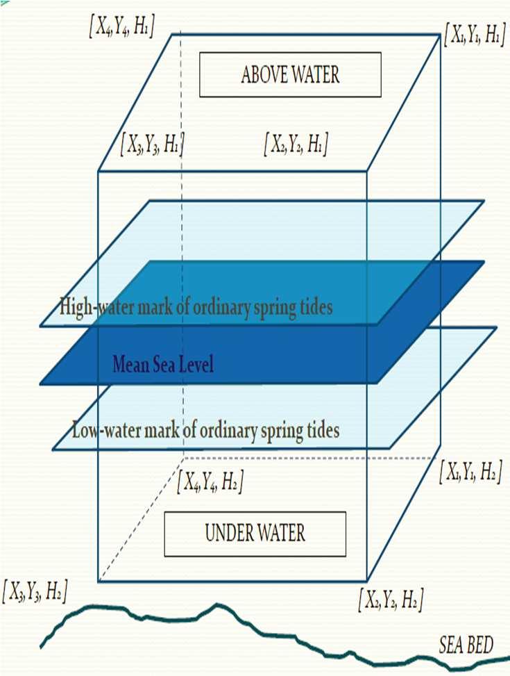
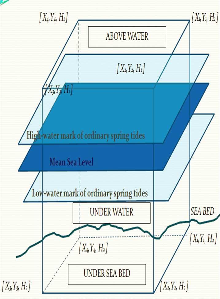
Tidal Datum Consistency for Marine Cadastre Littoral Zone Commencement in Malaysia
 Tidal Datum Consistency for Marine Cadastre Littoral Zone Commencement in Malaysia Rasheila Rahibulsadri, Abdullah Hisam Omar, Ashraf Abdullah, Wan Muhammad Aizzat Wan Azhar, Chan Keat Lim, Teng Chee Hua,
Development of Multipurpose Land Administration Systems
 Development of Multipurpose Land Administration Systems Hrvoje MATIJEVIĆ, Miodrag ROIĆ, Hrvoje TOMIĆ, Croatia Keywords: Land Administration, Land Management, Transformation, Land Governance SUMMARY Today
Demonstrate knowledge of, and extract, cadastral data from Landonline
 Page 1 of 5 Demonstrate knowledge of, and extract, cadastral data from Landonline Level 3 Credits 5 Purpose This unit standard is for people who are working in the surveying industry in jobs which involve
LAND ADMINISTRATION SYSTEM IN BRUNEI DARUSSALAM
 LAND ADMINISTRATION SYSTEM IN BRUNEI DARUSSALAM Presenter: Maslina Abu Bakar Brunei Darussalam AVA-Brunei Chapter 1 Presentation Content: 1. Introduction. 2. Land Administration. 3. Relevant Laws on Land
Ministry of Mines, Industry and SME
 Republic of Senegal Ministry of Mines, Industry and SME User Conference 2010 08/02/2010 COPYRIGHT 2010. SPATIAL DIMENSION (PTY) LTD. A MINING CADASTRE IN SENEGAL: IMPLEMENTATION PROCESS AND ORGANIZATIONAL
Centre for SDIs and Land Administration Department of Geomatics Spatial systems to support sustainable development
 Centre for SDIs and Land Administration Department of Geomatics MODERN CADASTER and LAND ADMINISTRATION تهران-مرداد 1386 2014 ..... 2 ماه Centre for SDIs and Land Administration Department of Geomatics
3D PROPERTY TYPES OF RIGHTS
 3D PROPERTY TYPES OF RIGHTS Tan Liat Choon Department of Survey and Mapping Malaysia Email: tanliatchoon@gmail.com Abstract The use of 3D property rights has become a common feature internationally and
Cadastre: definitions
 Introduction New vision towards a multipurpose cadastral system to support land management in Morocco Moha EL-AYACHI, El Hassane SEMLALI, Mohamed ETTARID, Driss TAHIRI, Institut Agronomique et Vétérinaire
Challenge to Implement International Cadastral Models Case Finland
 FIG Articleof the Month April 20 Challenge to Implement International Cadastral Models Case Finland Tarja Myllymäki and Tarja Pykälä 200-04-5 The topics are In European level INSPIRE Experiences, similarities,
Initial Design to Develop a Cadastral System that Supports Digital Cadastre, 3D and Provenance for Singapore
 Initial Design to Develop a Cadastral System that Supports Digital Cadastre, 3D and Provenance for Singapore Kean Huat SOON, Derick TAN and Victor KHOO, Singapore Key words: SG LandXML, SG LADM, 3D, Provenance
Ownership Data in Cadastral Information System of Sofia (CIS Sofia) from the Available Cadastral Map
 from the Available Cadastral Map") Ownership Data in Cadastral Information System of Sofia (CIS Sofia) from the Available Cadastral Map Key words: ABSTRACT Lydmila LAZAROVA, Bulgaria CIS Sofia is created and maintained by GIS Sofia ltd,
Ownership Data in Cadastral Information System of Sofia (CIS Sofia) from the Available Cadastral Map Key words: ABSTRACT Lydmila LAZAROVA, Bulgaria CIS Sofia is created and maintained by GIS Sofia ltd,
Egyptian Nationwide Title Cadastre System
 Kholoud SAAD, Egypt Key words: Cadastre, Registration, Urban, Rural, National Cadastre, Automation, reengineering. SUMMARY With growing need for integrated information, Enterprise Solutions has become
HOUSING AND PROPERTY MARKET IN LITHUANIA CONTENTS
 HOUSING AND PROPERTY MARKET IN LITHUANIA Kęstutis Sabaliauskas, Director General State Enterprise Centre of Registers, Lithuania Kestutis.Sabaliauskas@registrucentras.lt CONTENTS Legal environment Real
How to read different Plan Formats & definitions of Lots & Common Property Presentation Notes
 How to read different Plan Formats & definitions of Lots & Common Property Presentation Notes This presentation provides a basic understanding of community titles schemes and the plans that generally accompany
INDIAN INSTITUTE OF TECHNOLOGY ROORKEE. Presentation on REAL TIME CADASTRAL SURVEYING SOLUTION WITH A SPECIAL IMPHESIS TO MODERN GPS TECHNOLOGY.
 INDIAN INSTITUTE OF TECHNOLOGY ROORKEE Presentation on REAL TIME CADASTRAL SURVEYING SOLUTION WITH A SPECIAL IMPHESIS TO MODERN GPS TECHNOLOGY By: Prof. Kamal Jain, Dept. of Civil Engg. IIT-Roorkee AIM
Field surveying inspection using tablets
 Field surveying inspection using tablets Rami Farraj, Ahmad Sghyyer Survey of Israel, Lincoln 1, Tel-Aviv, Israel rami@mapi.gov.il ahmad@mapi.gov.il Key words: Field Surveying, Cadastre, Mapping Procedures
Malaysian 3D Property Legislation-A Preliminary Approach
 17 Malaysian 3D Property Legislation-A Preliminary Approach 1 2 3 Tan Liat Choon, Dr. Khadijah Binti Hussin, Sr. Ernest Khoo Hock Oon Abstract Malaysian land administration provides a variety of rights,
Lessons for federated countries that have state land registries the Australian experience
 Lessons for federated countries that have state land registries the Australian experience Ian Williamson Centre for SDI and Land Administration Department Infrastructure Engineering University of Melbourne
New Challenges to SiFUS of Strata Schemes
 1 New Challenges to SiFUS of Strata Schemes Paper prepared & presented by: Sr. Wong Kok Soo, FRISM, MPEPS, MMIPPM, MMIEA, MMIPEAC wongkoksoo@burgessrawson.com.my TEL. +603-2260 2300 HP. 012-3321 867 28
A CADASTRAL GEODATA BASE FOR LAND ADMINISTRATION USING ARCGIS CADASTRAL FABRIC MODEL A CASE STUDY OF UWANI ENUGU, ENUGU STATE, NIGERIA
 A CADASTRAL GEODATA BASE FOR LAND ADMINISTRATION USING ARCGIS CADASTRAL FABRIC MODEL A CASE STUDY OF UWANI ENUGU, ENUGU STATE, NIGERIA BY Ndukwu, Raphael. Ike Department of Geoinformatics & Surveying University
A Geocoded Cadastral Fabric as a Precondition for a Sustainable Land Management System
 A Geocoded Fabric as a Precondition for a Sustainable Land Management System Gottfried KONECNY, Germany; J.P. LAUZON, Canada; Abdul Salam MOHAMMED, India Key words: SDI,, Parcel Boundaries, GPS-GNSS, Land
CHAPTER 4 3D PROPERTY TYPE IN MALAYSIA
 75 CHAPTER 4 3D PROPERTY TYPE IN MALAYSIA 4.1 Introduction The aim of this chapter is to provide an introduction to 3D properties in Malaysia. Familiarity with the cadastral system is essential for a better
IT Solutions in Supporting Rwanda Land Administration System
 Ease of Doing Business Initiative Conference 2016 Digitizing Government business Leveraging ICT to enhance the Business Environment IT Solutions in Supporting Rwanda Land Administration System Pothin MUVARA
Commission No : 5 RCBMS : OVERVIEW
 RFID-Based Cadastral Boundary Mark System (RCBMS Abdullah Hisam Omar Tajul Ariffin Musa Ivin Amri Musliman Siti Syukriah Khamdan Kamaludin Omar Universiti Teknologi Malaysia Email: abdullahhisham@utm.my
Linking the Land Information Systems in the Philippines Using the LADM as a Global Schema
 Linking the Land Information Systems in the Philippines Using the LADM as a Global Schema Romer Kristi ARANAS, Rhodora GONZALEZ and Louie Balicanta, Philippines Key words: Digital cadastre, e-governance,
Presented at the FIG Congress 2018, May 6-11, 2018 in Istanbul, Turkey
 Presented at the FIG Congress 2018, May 6-11, 2018 in Istanbul, Turkey 5 Bibliometric Analysis of Articles Presented Under Commission 7: A Case of the 25th Fig Congress in Malaysia in 2014 Zeynel Abidin
A Method For Building Legal Digital Cadastre Without Using Cadastral Measurements Field Book Data Is It Accurate Enough?
 A Method For Building Legal Digital Cadastre Without Using Cadastral Measurements Field Book Data Is It Jad JARROUSH, Dmitri BRICKMAN, Israel Key words: Digital Cadastre, Least Squares Cadastral Computations,
REGISTRATION OF PROPERTIES IN STRATA
 REGISTRATION OF PROPERTIES IN STRATA REPORT ON THE WORKING SESSIONS INTRODUCTION A cadastre is usually, and in most countries, a parcel-based, and up-to-date land information system containing records
MASS REGISTRATION OF LAND PARCELS USING FIT-FOR-PURPOSE LAND ADMINISTRATION: PROCEDURES AND METHODS
 MASS REGISTRATION OF LAND PARCELS USING FIT-FOR-PURPOSE LAND ADMINISTRATION: PROCEDURES AND METHODS TAREK ZEIN Hansa Luftbild AG, Germany zein@hansaluftbild.de Paper prepared for presentation at the 2017
Geodetic Infrastructure in Samoa. FIG Pacific Small Islands Developing States Symposium September 2013, Suva, FIJI.
 Geodetic Infrastructure in Samoa. FIG Pacific Small Islands Developing States Symposium 18 20 September 2013, Suva, FIJI. FIG Commission 5 Position and Measurement United Nations Global Geospatial Information
Land Registration in a Digital Environment.
 Land Registration in a Digital Environment Emmanuel Tembo, Johnson Kampamba and Boipuso Nkwae tembo@mopipi.ub.bw Paper presented 17 th June 2014, Kuala Lumpur, Malaysia XXV International Federation of
PREPARING SURVEY TENDER GIS DATABASE OUTCOMES
 PREPARING SURVEY TENDER SPECIFICATIONS FOR PROJECT GIS DATABASE OUTCOMES Presentation by Ian Harper GEODATA AUSTRALIA ESRI User Conference 2009 24 st July 2009 BACKGROUND GIS databases now provide a more
DEVELOPING A NEW CADASTRAL REGISTRATION APPROACH
 4 DEVELOPING A NEW CADASTRAL REGISTRATION APPROACH Disediakan Oleh Tan Liat Choon and Khadijah binti Hussin Department of Land Administration and Development, Universiti Teknologi Malaysia, Johor, Malaysia.
FACT SHEET: Tenure requirements for Major Customer Connections
 FACT SHEET: for Major Customer Connections Purpose February 2014 Version 1.0 This fact sheet describes the types of underlying land tenure required by Ergon Energy in situations where a Major Customer
LAND ADMINISTRATION REFORM IN GHANA DR W.ODAME LARBI PROJECT DIRECTOR GHANA LAND ADMINISTRATION PROJECT
 LAND ADMINISTRATION REFORM IN GHANA DR W.ODAME LARBI PROJECT DIRECTOR GHANA LAND ADMINISTRATION PROJECT 1 OUTLINE Background Long Term Objectives of the LAP Objectives of Phase 1 of LAP The Components
Reforming the Land Sector in Jamaica
 Silburn CLARKE and Llewelyn ALLEN, Jamaica Key words: tenure, cadastre, land reform, adjudication, public awareness, land titling, GPS, parcel mapping, traversing, land legislation, tenure regularisation,
GIS & GPS Applications in Valuation/Appraisal Assessments
 GIS & GPS Applications in Valuation/Appraisal Assessments Simon ADCOCK, Australia Key words: GIS, GPS, mass assessments, 3-dimensional, modelling. SUMMARY The development of GIS and GPS systems has substantially
RESEARCHERS. Vertical Living Phenomenon in Malaysia. Presented by: Sr Ainoriza Mohd Aini
 XXV FIG Congress 16-1 June 14 Kuala Lumpur Vertical Living Phenomenon in Malaysia Presented by: Sr Ainoriza Mohd Aini Studies of Urban & Regional Real Estate (SURE) Faculty of Built Environment University
Rules for Cadastral Survey 2010
 Rules for Cadastral Survey 2010 LINZS65000 24 May 2010 www.linz.govt.nz Under section 49 of the Cadastral Survey Act 2002, I hereby make the Rules for Cadastral Survey 2010 These Rules are effective from
Presented at the FIG Working Week 2016, May 2-6, 2016 in Christchurch, New Zealand
 Presented at the FIG Working Week 2016, May 2-6, 2016 in Christchurch, New Zealand The IMPULS Project Is a Project About Cooperation, Coordination, Transparency and Data Sharing A SDI project in the Western
Towards 3D and 4D Cadastre in Croatia
 Nikola VUČIĆ, Miodrag ROIĆ and Danko MARKOVINOVIĆ, Croatia Key words: 3D Cadastre, 4D Cadastre, Croatia, LADM, Utility Cadastre SUMMARY Cadastral systems need to be designed and supported from three dimensional
FIG-WB Forum on Land Administration and reform in Sub-Sahara Africa
 FIG-WB Forum on Land Administration and reform in Sub-Sahara Africa Chris Mnyanga Ministry of Lands UNITED REPUBLIC OF TANZANIA] FIG WORKING WEEK, Abuja, NIGERIA 2013-6-10 MAY 2013 Country at Glance UNITED
A beautiful setting. The Evolving Role of Cadastral Systems in Support of Good Land Governance. Setting the scene
 The Evolving Role of Cadastral Systems in Support of Good Land Governance Prof. Stig Enemark President Aalborg University, Denmark THE DIGITAL CADASTRAL MAP FIG COMMISSION 7 OPEN SYMPOSIUM KARLOVY VARY,
How to Utilize the Citizens to Gather VGI as a Support for 3D Cadastre Transition
 How to Utilize the Citizens to Gather VGI as a Support for 3D Cadastre Transition Nikola VUČIĆ, Vlado CETL and Miodrag ROIĆ, Croatia Key words: 3D cadastre, crowdsourcing, land administration, LADM, VGI
Presented by: Stewart Information International, Inc. Jack McKenna
 Presented by: Stewart Information International, Inc. Jack McKenna Held at the: 2007 ESRI Survey & Engineering GIS Summit San Diego Convention Center San Diego, California June 16-19, 2007 Integrating
8726. Land surveying defined
 8726. Land surveying defined A person, including any person employed by the state or by a city, county, or city and county within the state, practices land surveying within the meaning of this chapter
Property Transactions in the Digital Age. The Property Cadastre in the Context of Spatial. Dr. Jens Riecken, NRW Ministry of the Interior
 Property Transactions in the Digital Age The Property Cadastre in the Context of Spatial Data Infrastructure (SDI) Dr. Jens Riecken, NRW Ministry of the Interior Property Transactions in the Digital Age
Participants of the Ministerial Meeting on Housing and Land Management on 8 October 2013 in Geneva
 Summary At its meeting on 2 April 2012, the Bureau of the Committee on Housing and Land Management of the United Nations Economic Commission for Europe agreed on the need for a Strategy for Sustainable
Surveyors Qualifications
 Surveyors Qualifications Præludium Surveyors Qualifications Lars Jansson, Director Lantmäteriet Henning Elmstrøm, President DdL 1 Agenda 1. Introduction 2. Basic framework conditions for cadastral systems
GLOBAL GEOSPATIAL MANAGEMENT INFORMATION
 GLOBAL GEOSPATIAL MANAGEMENT INFORMATION SEOUL, KOREA 24 th to 26 th October 2011 COUNTRY REPORT - REPUBLIC OF BOTSWANA 1. INTRODUCTION 1.1. SOCIAL, ECONOMIC AND POLITICAL BACKGROUND Botswana attained
Directorate of Survey and Mapping NAMIBIA. Cadastral Information System. Vehupisa Kasuko Tjatindi Surveyor Directorate of Survey and Mapping NAMIBIA
 Vehupisa Kasuko Tjatindi Directorate of Survey and Mapping NAMIBIA Tel: +64 61 965000 Directorate of Survey and Mapping NAMIBIA Cadastral Information System Introduction Over the past few decades cadastral