Alternatives for Economic Boundary Determination in the Establishment of a Cadastral System. Paper to the FIG Working Week 2012 Rome, May 9, 2012
|
|
|
- Darrell Pierce
- 5 years ago
- Views:
Transcription
1 Alternatives for Economic Boundary Determination in the Establishment of a Cadastral System Paper to the FIG Working Week 2012 Rome, May 9, 2012 by Gottfried Konecny Emeritus Professor Leibniz University Hannover, Germany Alternatives for Economic Boundary Determination in the Establishment of a Cadastral System 1. Introduction why are efficient land registration systems needed? Hernando de Soto and Word Bank, Cadastre 2014, Options 2. Land Boundaries 3. Monumentation of Boundaries 4. Modern Technology tools to establish a Parcel Fabric 4.1. GPS GNSS 4.2. Digital Orthophoto Mapping 4.3. Digital Geodatabase Structure 4.4. High Resolution Satellite Imagery 5. Conclusion 1


2 1. Introduction Hernando de Soto Economist born 1941 in Peru he stated: insecure land rights deprive a country of the capacity of land to serve as collateral for mortgages; land becomes dead capital 1. Introduction FIG stated: about 50 countries have efficient land registration systems another 50 countries are in the process to establish one this still leaves another 90 countries without one The World Bank: has financed establishment of efficient land registration systems with 1.2B $ during the last 10 years Professional Literature: has been made available to discuss the benefits of efficient land registration systems according to the model Cadastre
 But not the global technical options: for SDI and data providers see butterfly diagram Purpose of the Paper: is to make a contribution in these aspects")

3 The tasks have been well described: Jürg Kaufmann in Cadastre 2014: Map and Register in digital form Williamson, Enemark, Wallace, Rajabifard Legal options (Deeds, Titles) Advantages (Sustainable land use planning, Valuation, Taxation) But not the global technical options: for SDI and data providers see butterfly diagram Purpose of the Paper: is to make a contribution in these aspects particularly with respect to boundary descriptions CADASTRE 2014: THE VISION FOR MODERN CADASTRAL SYSTEMS FIG studied the development of modern cadastres in the years 1994 to The result of the studies was the publication Cadastre 2014: A Vision for Future Cadastral Systems. Today Cadastre 2014 is still the base for further studies e.g. for Cadastre The vision Cadastre 2014 is the base of the development trend. The vision is becoming a reality..nsdi Conference, 6-7 October 2011, Baku, Azerbaijan 6 3


4 Statement 1 on Cadastre 2014 Cadastre 2014 will show the complete legal situation of land, including public rights and restrictions! Comment: The population of the world is growing. The consumption on the land is increasing. The absolute control of the individual or of legal entities of land is increasingly being restricted by public interest. To provide security of the land tenure, all facts about land must be made obvious by the cadastral system of the future. Consequences: A new thematic model is necessary. Surveyors must take into consideration public law. 4
 3.")
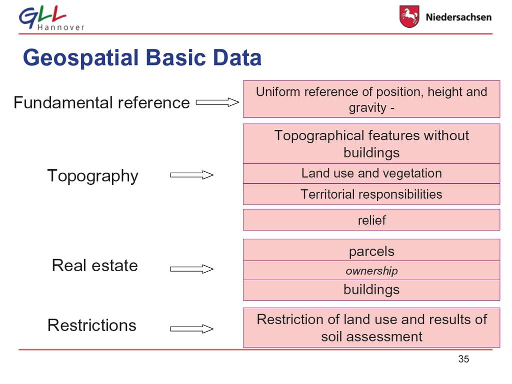
5 2. Boundaries and the Cadastre: Options: which Cadastre? 1. Tax Cadastre does not need boundaries, only areas (resolution 1m) 2. Ownership Cadastre needs accurate boundaries, but this is in the owner s interest only (resolution 1 cm) 3. Multipurpose Cadastre needs map accuracy boundaries only, this is in the public interest to create an SDI, even though land registration does not need it (resolution 1 dm) 5


6 Metes and bounds description of boundaries used in the USA disadvantage: not geocoded, no topogy for parcel fabric Map description of boundaries if analog, limited to scale, but in general geocoded if digital, coordinates of survey determine accuracy and topology Object definition of parcels in digital data bases the measured boundary point coordinates define the boundaries with survey accuracy and the boundaries determine the topology Metes and bounds description Map description of boundaries 6

7 Map and Coordinate Description of Boundaries 7
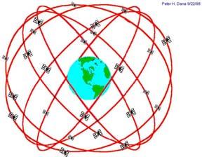
8 If buildigs are considered part of the cadastre, then this is the first step to a multipurpose cadastre 3. Monumentation of Boundaries advantage: disadvantage: fixed to the earth surface monuments are destroyed due to erosion, decay, construction, human action monuments were surveyed in the past relative to topographic objects (trees, buildings) monuments already were used in Babylonia 1200 B.C. and by the Romans 20 B.C. (Pollio) to 104 A.D. (Frontius) or absolute depending on current positioning technology astronomic positioning triangulation and traversing in geodetic networks electronic distance measurement after 1985 DGPS 8


9 Be careful: a legally monumented boundary is not a topographic boundary as visible by a fence or a building! boundary onument an urban area Germany 9


10 oundary onument a rural area Germany 10

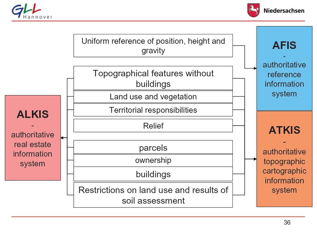
11 Integration of cadastre, topography and utilities depends in multipurpose cadasters often depends on the existence of local SDI s and the laws to permit integration Integration often does not occur because certain tasks are geserved for government operations and some for the private sector 11
12 12


13 Digital Topographic Map - DTK 25 example for a value added map 13


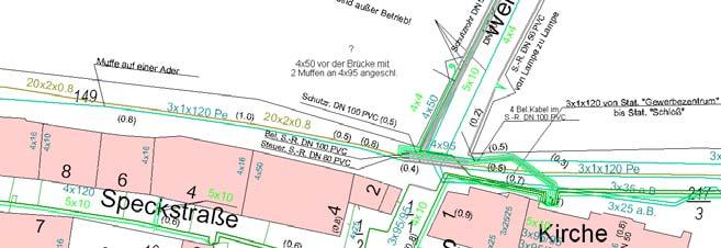
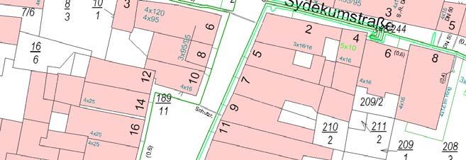
14 ALK mit Stadttopographie, Delmenhorst A value added map for street furniture Stromleitungsdokumentation Stadt Han. Münden a value added map for utilities 14


; or Gas")
 or")
15 But utilities may also be identified diferently e.g. Water pipe (1.6m away, 3.3m deep, diameter 50mm); or Gas pipe (1m away, 5.9m deep) or Electric cable (8.3m away, 1.4m deep) 15


16 Feature Based Feature Life Cycles Change Only Update Better description Of features Database ready Interdependency between layers The survey of topographic point features by techeometry in the UK the Ordnance Survey has made a commitment to the public to update every topographic feature within 6 months 16

 and Version")
17 Topologically consistent data for areas surveyed with boundaries True polygon data area features are identified with a unique number, the TOID Unique feature IDs (TOIDS) and Version numbers 17


")
18 a topographic map is an unsharp boundary map (as seen in the U.K.) an iron bar is not a stable permanent boundary marker (as seen in the Arabian desert) Settlements are generally faster than maps 18
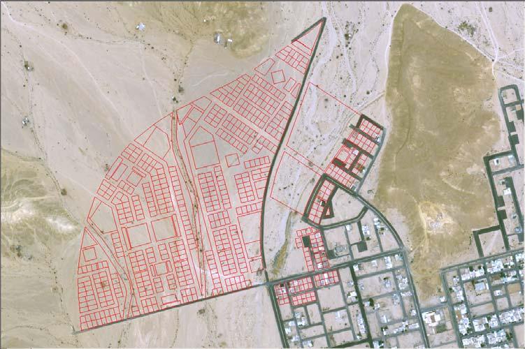
19 Rapidly growing areas with lagal transaction s are usually planned, often with computers These planned developments just need geocoding, so that they can immediately be used as cadastral plans after stakeout Cadastral problems therefore then concern illegal occupation areas areas wich have not been properly recorded 4.1. Modern DGPS Adjudication Surveys via GNSS Used in Georgia and Cambodia for New Cadastre Establishment Suitable for Transaction based Update Surveys 19


20 Photography of Deeds Used Technology Georeferencing (example Georgia) 20


21 Local Boundary Survey Cost for registering a parcel (includes adjudication ans survey) 8 Progress: Georgia within 5 years 21


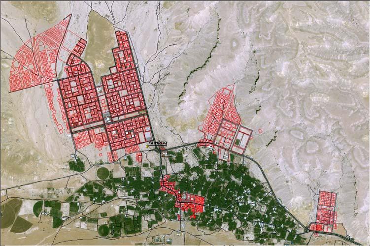
22 4.2. Image Adjudication: if topographic features can be identified in aerial images with 0.1 to 0.2m GSD in urban areas, or with 0.4m GSD in rural areas, or with 0.5 to 2.5m GSD in satellite images (GeoEye, Quickbird, Worldview, Spot5) then image adjudication becomes possible Prerequisite for georeferencing is orthoimage generation and geocoding The result is a Preliminary Parcel Map, which is adequate for the land register to identify each uniquely identified land parcel and attach attributes to it Image Adjudication German Technical Cooperation Project Cadastre in Mali 22
23 5. Geodatabase when the database for storing the geometric features is suitably structures according to identifiable points, lines, areas, then the geometry may be improved by a change in coordinates based on more precise surveys, e.g. by GNSS This can be done sporadically, when transactions and new surveys occur The Preliminary Parcel Map may be geometrically improved sporadically for all cadastral objects, which require a change In due time the database will improve ist overall geometric accuracy In Transformation Countries, such as the Ukraine, 1) agricultural land has been distributed to citizens, 2) They received a certificate from the Government 3) But local survey companies had to distribute the fields on the ground 4) The Government instituted an Orthophoto imaging program for the entire contry as quality control 5) In the Odessa Oblast 17% of the parcels had to be geometrically corrected This means: The image adjudication methodology using ortho imagery is also applicable for verification of inaccuracies of old or recent survey errors 23


24 Parcel Fabric as a result of ground surveys Orthophoto Program of the Ukraine 24


25 Superposition of Cadastral Fabric from Surveyors with Orthophoto Kibera, tha largest slum of Nairobi with 1.5M people does not show details in official maps (1:50 000) 25


26 But details of Kibera, Nairobi s slum with 1.5M people show well in Google Earth (Ikonos Image 1m GSD) 26
27 27
28 Conclusion: 1. Classical Methods of establishing a cadastre are expensive and time consuming, because of the ground survey procedures 2. Image Adjudication procedures are an intermadiate inexpensive and fast step to establish land registration systems efficiently 3. Ground Survey Adjudication procedures using GNSS may be utilized in sporadic steps for needed transactions 4. Databases with appropriate design may be used to gradually improve the geometric accuracy of the parcel fabric 5. Possibilities should be made for fast and economic generation of land registratin systems, so that the many countries not benefiting from one will be able to benefit as fast as possible 28
A Geocoded Cadastral Fabric as a Precondition for a Sustainable Land Management System
 A Geocoded Fabric as a Precondition for a Sustainable Land Management System Gottfried KONECNY, Germany; J.P. LAUZON, Canada; Abdul Salam MOHAMMED, India Key words: SDI,, Parcel Boundaries, GPS-GNSS, Land
A beautiful setting. The Evolving Role of Cadastral Systems in Support of Good Land Governance. Setting the scene
 The Evolving Role of Cadastral Systems in Support of Good Land Governance Prof. Stig Enemark President Aalborg University, Denmark THE DIGITAL CADASTRAL MAP FIG COMMISSION 7 OPEN SYMPOSIUM KARLOVY VARY,
Jack McKenna, Director of Business Development, Africa and the Caribbean
 Presented at the FIG Working Week 2016, May 2-6, 2016 in Christchurch, New Zealand Jack McKenna, Director of Business Development, Africa and the Caribbean FIG WORKING WEEK 2016 Fit for Purpose Parcel
INDIAN INSTITUTE OF TECHNOLOGY ROORKEE. Presentation on REAL TIME CADASTRAL SURVEYING SOLUTION WITH A SPECIAL IMPHESIS TO MODERN GPS TECHNOLOGY.
 INDIAN INSTITUTE OF TECHNOLOGY ROORKEE Presentation on REAL TIME CADASTRAL SURVEYING SOLUTION WITH A SPECIAL IMPHESIS TO MODERN GPS TECHNOLOGY By: Prof. Kamal Jain, Dept. of Civil Engg. IIT-Roorkee AIM
Cadastral Survey in the 21 st Century. Gavin Adlington. Land Program Team Leader Europe and Central Asia Region (ECA)
") E-learning Series Cadastral Survey in the 21 st Century June 3, 2010 Gavin Adlington. Land Program Team Leader Europe and Central Asia Region (ECA) The World Bank Content : Purpose of cadastral survey
E-learning Series Cadastral Survey in the 21 st Century June 3, 2010 Gavin Adlington. Land Program Team Leader Europe and Central Asia Region (ECA) The World Bank Content : Purpose of cadastral survey
COUNTRY REPORT ON CADASTRE AND LAND REGISTRAION IN IRAN. By: Hamid Berenjkar, IRAN
 COUNTRY REPORT ON CADASTRE AND LAND REGISTRAION IN IRAN By: Hamid Berenjkar, IRAN Key words: Comprehensive Cadastre, Cadastre System, Cadastral Survey, Land Book, Iran ABSTRACT Land registration and cadastral
The New Technology of a Survey Data Model and Cadastral Fabric as the Foundation for a Future Land Administration System.
 The New Technology of a Survey Data Model and Cadastral Fabric as the Foundation for a Future Land Ian HARPER, Australia Key words: cadastral modelling, survey data model, Survey Accuracy, Cadastre 2014
MASS REGISTRATION OF LAND PARCELS USING FIT-FOR-PURPOSE LAND ADMINISTRATION: PROCEDURES AND METHODS
 MASS REGISTRATION OF LAND PARCELS USING FIT-FOR-PURPOSE LAND ADMINISTRATION: PROCEDURES AND METHODS TAREK ZEIN Hansa Luftbild AG, Germany zein@hansaluftbild.de Paper prepared for presentation at the 2017
A CADASTRAL GEODATA BASE FOR LAND ADMINISTRATION USING ARCGIS CADASTRAL FABRIC MODEL A CASE STUDY OF UWANI ENUGU, ENUGU STATE, NIGERIA
 A CADASTRAL GEODATA BASE FOR LAND ADMINISTRATION USING ARCGIS CADASTRAL FABRIC MODEL A CASE STUDY OF UWANI ENUGU, ENUGU STATE, NIGERIA BY Ndukwu, Raphael. Ike Department of Geoinformatics & Surveying University
Land Tenure and Geospatial Data and Technology
 Land Tenure and Geospatial Data and Technology Ioana Bouvier E3/Land and Urban, USAID Senior Geospatial Analyst January 23, 2018 January 23, 2018 1 OUTLINE 1. Overview of geospatial data and technology
GNSS NETWORKS & CADASTRE GNSS AND THE INTERSECTION OF GEODESY AND THE CADASTRE IN KINGDOM OF SAUDI ARABIA SUBJECT TO TALKS
 GNSS NETWORKS & CADASTRE GPS GALILEO GLONASS COMPASS (BEIDOU-2) GNSS AND THE INTERSECTION OF GEODESY AND THE CADASTRE IN KINGDOM OF SAUDI ARABIA 1 SUBJECT TO TALKS GNSS NETWORK From local to global datum
Transforming Society The Story of the Danish Cadastre from late 1700s
 FIG WORKING WEEK, HELSINKI, FINLAND, 29 MAY 2 JUNE 2017 HISTORY SYMPOSIUM 28 MAY 2017 Transforming Society The Story of the Danish Cadastre from late 1700s Stig ENEMARK and Pia DAHL HØJGAARD, Denmark Key
The Digital Cadastral Database and the Role of the Private Licensed Surveyors in Denmark
 IRISH INSTITUTE OF SURVEYORS, DUBLIN INSTITUTE OF TECHNOLOGY, 23 NOVEMBER 2005 PUBLISHED IN IIS NEWS, WINTHER 2006. The Digital Cadastral Database and the Role of the Private Licensed Surveyors in Denmark
Scenic Nepal. Land Administration Systems. Outline of Presentation. Interests in land. Rights: Registration and security of tenure positions
 Scenic Nepal Land Administration Systems Managing Rights, Restrictions, and Responsibilities in Land Prof. Stig Enemark President Aalborg University, Denmark SURVEY DEPARTMENT KATHMANDU, NEPAL. 16 FEBRUARY
A Method For Building Legal Digital Cadastre Without Using Cadastral Measurements Field Book Data Is It Accurate Enough?
 A Method For Building Legal Digital Cadastre Without Using Cadastral Measurements Field Book Data Is It Jad JARROUSH, Dmitri BRICKMAN, Israel Key words: Digital Cadastre, Least Squares Cadastral Computations,
Cadastre A Vision on Future Cadastral Systems
 Cadastre 2014 - A Vision on Future Cadastral Systems Jürg Kaufmann - 1 - CONTENTS ABOUT FIG ENVIRONMENT FOR THE DEVELOPMENT OF CADASTRE 2014 DEVELOPMENT OF CADASTRE 2014 PRINCIPLES OF CADASTRE 2014 EFFECTS
Cadastre: definitions
 Introduction New vision towards a multipurpose cadastral system to support land management in Morocco Moha EL-AYACHI, El Hassane SEMLALI, Mohamed ETTARID, Driss TAHIRI, Institut Agronomique et Vétérinaire
Cadastral Futures building a new vision for the nature and role of cadastres. XXIV FIG International Congress Sydney, April 11-15
 Cadastral Futures building a new vision for the nature and role of cadastres XXIV FIG International Congress Sydney, April 11-15 Rohan Bennett, Abbas Rajabifard, Mohsen Kalantari, Jude Wallace, Ian Williamson
FIG-WB Forum on Land Administration and reform in Sub-Sahara Africa
 FIG-WB Forum on Land Administration and reform in Sub-Sahara Africa Chris Mnyanga Ministry of Lands UNITED REPUBLIC OF TANZANIA] FIG WORKING WEEK, Abuja, NIGERIA 2013-6-10 MAY 2013 Country at Glance UNITED
Quality Improvement to Cadastral Information in Sweden
 Gunnar BLIXT, Sweden Key words: digital cadastre, quality, cadastral index map, real property register. SUMMARY Lantmäteriet is a governmental agency which gives support for creating an efficient and sustainable
How a Cadaster Might Look Like in Finland in the Year 2035?
 How a Cadaster Might Look Like in Finland in the Year 2035? Mr. MARKKU Eino Olavi MARKKULA, Finland Key words; Cadastre, Coordinates, Digitised Process, Key Registers, Land Register Summary The Finnish
The Fit- for-purpose Concept
 The Fit- for-purpose Concept Building Spatial Frameworks for Sustainable Land Governance in Sub-Sahara Africa Prof. Stig Enemark Honorary President Aalborg University, Denmark LAND POLICIES AND LAND GOVERNANCE,
LADM-based Crowdsourced 3D Cadastral Surveying Potential and Perspectives
 National Technical University Of Athens School of Rural and Surveying Engineering LADM-based Crowdsourced 3D Cadastral Surveying Potential and Perspectives Maria Gkeli, Surveying Engineer, PhD student
Land Administration And Spatial Data Infrastructures
 Land Administration And Spatial Data Infrastructures Ian WILLIAMSON, Donald GRANT and Abbas RAJABIFARD Centre for SDIs and Land Administration Department of Geomatics University of Melbourne, Australia
Lessons for federated countries that have state land registries the Australian experience
 Lessons for federated countries that have state land registries the Australian experience Ian Williamson Centre for SDI and Land Administration Department Infrastructure Engineering University of Melbourne
Systematic Land Information Management (SLIM)
") Systematic Land Information Management (SLIM) By Mr. Jukka Nieminen Jaakko Pöyry Infra Soil and Water Ltd. Expert Group Meeting on Secure Land Tenure: New Legal Frameworks and Tools Nairobi 12 November
Systematic Land Information Management (SLIM) By Mr. Jukka Nieminen Jaakko Pöyry Infra Soil and Water Ltd. Expert Group Meeting on Secure Land Tenure: New Legal Frameworks and Tools Nairobi 12 November
Challenges for the multi purpose cadastre
 Jens RIECKEN, Markus SEIFERT, Germany Key words: Multi purpose cadastre, 3d-cadastre, land use, SDI, solar cadastre SUMMARY Over the past 30 years, with the progress of information technologies the development
OUTLINE OF PRESENTATION
 LAND REGISTRATION USING AERIAL PHOTOGRAPH IN NAMIBIA COSTS AND LESSONS Donatha Kapitango Ministry of Lands and Resettlement Marcel Meijs German Development Agency OUTLINE OF PRESENTATION 1. Introduction
Geoinformation Technologies in Land Management and Beyond: Case of Georgia
 Geoinformation Technologies in Land Management and Beyond: Case of Georgia Joseph SALUKVADZE Professor, Department of Human Geography, Co-team Leader, Cadastre and Land Register Project, Co-financed by
Progress Report on Green Paper. Dr. Paddy Prendergast. on behalf of the. IIS Commission on Land Registration
 Progress Report on Green Paper By Dr. Paddy Prendergast on behalf of the IIS Commission on Land Registration Paddy Prendergast - Chair Brendan Sweeny - Hempenstall Surveys Paul Corrigan - P Corrigan Associates
The Challenge to Implement International Cadastral Models Case Finland 1
 The Challenge to Implement International Cadastral Models Case Finland 1 Tarja MYLLYMÄKI and Tarja PYKÄLÄ, Finland Key words: cadastre, modelling, LADM, INSPIRE SUMMARY Efforts are currently made to develop
DIGITAL CADASTRAL MAP: A MULTIPURPOSE TOOL FOR SUSTAINABLE DEVELOPMENT
 DIGITAL CADASTRAL MAP: A MULTIPURPOSE TOOL FOR SUSTAINABLE DEVELOPMENT Moha ELAYACHI and Prof. El Hassane SEMLALI, Morocco Key words: cadastral information, digital cadastral map, design, implementation,
Use of data in Ukraine for sustainable economic growth. Oleksandr Maliuk State Service of Ukraine for Geodesy, Cartography and Cadastre
 Use of data in Ukraine for sustainable economic growth Oleksandr Maliuk State Service of Ukraine for Geodesy, Cartography and Cadastre Kehl, 2017 Content of the presentation Ukraine & StateGeoCadastre:
From Measurement to Management
 From Measurement to Management The changing role of the land surveyors Prof. Stig Enemark Aalborg University, Denmark LAND MANAGEMENT AND HUMAN RIGHTS INTERNATIONAL SEMINAR, HØGSKOLEN I BERGEN, 8 9 SEPTEMBER
Land surveying is probably the (second) oldest profession in the world
 oldest profession in the world") Land Surveying and Land Management in an International Perspective Prof Stig Enemark Honorary President Aalborg University, Denmark CADASTRE IN A DIGITAL WORLD NORDIC AND GLOBAL PRESPECTIVES INTERNATIONAL
Land Surveying and Land Management in an International Perspective Prof Stig Enemark Honorary President Aalborg University, Denmark CADASTRE IN A DIGITAL WORLD NORDIC AND GLOBAL PRESPECTIVES INTERNATIONAL
Unified Land Administration for a Better Spatial Infrastructure
 Unified Land Administration for a Better Spatial Infrastructure Gyula IVÁN Institute of Geodesy, Cartography & Remote Sensing FÖMI (HUNGARY) Open Symposium 30th Korean Cadastral Seminar & FIG Commission
The Danish Digital Cadastral Map A Tool for Land Management
 The Danish Digital Cadastral Map A Tool for Land Management Søren CHRISTENSEN, Denmark Key words: Digital cadastre, restrictions pertaining to public law, land management. ABSTRACT The establishments of
Germany on the way to a 4D-Cadastre
 Germany on the way to a 4D-Cadastre Dr. Jens Riecken (DVW Vicepresident), Ulrich Gruber, Dr. Markus Seifert (DVW WG Geoinformation) TS 9.1 4D Cadastre, Land Domain Models & Concepts 1 Content About my
Responsible and Innovative Land Administration
 Responsible and Innovative Land Administration An Example from Ethiopia 3 RD DECEMBER 2018 Outline A few words about NIRAS Fit-for-purpose: A low-tech disruptive approach? The REILA Project in Ethiopia
Land Markets and Land Rights in support of the Millennium Development Goals
 Land Markets and Land Rights in support of the Millennium Development Goals A Global Perspective Prof. Stig Enemark President Aalborg University, Denmark 3rd LAND ADMINISTRATION FORUM FOR THE ASIA AND
Hi-tech Survey Operation using Modern Technologies: Concept & Process Flow
 Hi-tech Survey Operation using Modern Technologies: Concept & Process Flow Presented by Sri Biswaranjan Rath Asst. Director,CLR Board of Revenue, Odisha Limitations of present system of surveying Survey
THINKING OUTSIDE THE TRIANGLE TAKING ADVANTAGE OF MODERN LAND MARKETS. Ian Williamson
 THINKING OUTSIDE THE TRIANGLE TAKING ADVANTAGE OF MODERN LAND MARKETS Ian Williamson Professor of Surveying and Land Information Head, Department of Geomatics Director, Centre for Spatial Data Infrastructures
Spatial Data Infrastructure in Sweden
 Spatial Data Infrastructure in Sweden Hans-Erik WIBERG, Sweden Key words: ABSTRACT Sweden was one of the first countries to address Data Infrastructure matters and have during several decades developed
CADASTRE 2014: New Challenges and Direction
 CADASTRE 2014: New Challenges and Direction Anna KRELLE and Abbas RAJABIFARD, Australia Key words: Cadastre, Cadastre 2014, Land Administration SUMMARY Land and land related activities form part of the
Presented by: Stewart Information International, Inc. Jack McKenna
 Presented by: Stewart Information International, Inc. Jack McKenna Held at the: 2007 ESRI Survey & Engineering GIS Summit San Diego Convention Center San Diego, California June 16-19, 2007 Integrating
Land Administration Infrastructures for Sustainable Development
 The Global Challenges Land Administration Infrastructures for Sustainable Development Prof. Stig Enemark Department of Development and Planning Aalborg, University, Denmark INTERNATIONAL CONFERENCE ON
Problems and Solution Proposals in Integration of Cadastral Data into Geographical Information System (GIS) in Turkey
 in Turkey") Problems and Solution Proposals in Integration of Cadastral Data into Geographical Information System (GIS) in Turkey Gülgün OZKAN, S. Savas DURDURAN, Ali ERDI and Bilal GIRGIN, Turkey Key words: Cadastre,
Problems and Solution Proposals in Integration of Cadastral Data into Geographical Information System (GIS) in Turkey Gülgün OZKAN, S. Savas DURDURAN, Ali ERDI and Bilal GIRGIN, Turkey Key words: Cadastre,
Addis Ababa: The Road Map to Progress through Securing Property Rights with Real Property Registration System
 Addis Ababa: The Road Map to Progress through Securing Property Rights with Real Property Registration System Tarek ZEIN; Dr. Paul HARTFIEL; Germany, and Zerihun Amdemariam BERISSO, Ethiopia Key words:
Cadastral Template 2003
 PCGIAP-Working Group 3 "Cadastre" FIG-Commission 7 "Cadastre and Land Management" Cadastral Template 2003 The establishment of a cadastral template is one of the objectives of Working Group 3 "Cadastre"
Field surveying inspection using tablets
 Field surveying inspection using tablets Rami Farraj, Ahmad Sghyyer Survey of Israel, Lincoln 1, Tel-Aviv, Israel rami@mapi.gov.il ahmad@mapi.gov.il Key words: Field Surveying, Cadastre, Mapping Procedures
The creation of a Survey Accurate Cadastral Map for surveyed areas in Trinidad & Tobago
 The creation of a Survey Accurate Cadastral Map for surveyed areas in Trinidad & Tobago Anesh Gopee, Keith Miller and Charisse Griffith Charles University of the West Indies Trinidad aneshtt@yahoo.com
From Parcel to Global Cadastre: Challenges and Issues of the Post-Reform Quebec Cadastre. Elisabetta Genovese, Francis Roy
 From Parcel to Global Cadastre: Challenges and Issues of the Post-Reform Quebec Cadastre Elisabetta Genovese, Francis Roy Department of Geomatic Sciences, Laval University, Québec, Canada elisabetta.genovese@scg.ulaval.ca
The programme is implemented
 Surveying Property valuation and spatial data tools to assist in land restitution by Jaco de Kock, GISCOE Land and tenure reform in the South African government context are beyond talk and have received
Digital Photogrammetry for Land Registration in Developing Countries
 , Republic of Korea Key words: Digital photogrammetry, Land registration, Stereo-Complication, Digital Cadastral Map, Azerbaijan, Developing countries SUMMARY While photogrammetry has been extensively
Centre for SDIs and Land Administration Department of Geomatics Spatial systems to support sustainable development
 Centre for SDIs and Land Administration Department of Geomatics MODERN CADASTER and LAND ADMINISTRATION تهران-مرداد 1386 2014 ..... 2 ماه Centre for SDIs and Land Administration Department of Geomatics
Fit for Purpose Parcel Mapping Methodologies for a Seamless Cadastre Database
 Fit for Purpose Parcel Mapping Methodologies for a Seamless Cadastre Database SUMMARY Author: Jack MCKENNA Fit for Purpose, Cadastral Mapping The joint FIG/World Bank Publication states that Fit-for-purpose
Key Registers in Finland and some views of Cadastre 2035
 Presented at the FIG Working Week 2016, May 2-6, 2016 in Christchurch, New Zealand Key Registers in Finland and some views of Cadastre 2035 FIG Working Week, Christchurch New Zealand May, the 3rd, 2016
FIG-WB Forum on Land Administration
 FIG-WB Forum on Land Administration and Reform in Sub-Sahara Africa [Nigeria] [Peter O. Adeniyi] FIG WORKING WEEK, Abuja, NIGERIA 2013-6-10 MAY 2013 Statistic Country at a Glance Total population 162,470,737
COORDINATED CADASTRES - A KEY TO BUILDING FUTURE GIS
 Proceedings of the Regional Conference on Managing Geographic Information Systems for Success, Melbourne, 3-4 July, pp.60-69 (1996). COORDINATED CADASTRES - A KEY TO BUILDING FUTURE GIS Ian P.Williamson
Country report, HUNGARY
 Country report, HUNGARY Gyula IVÁN Institute of Geodesy, Cartography & Remote Sensing (FÖMI) HUNGARY FIG Commission 7 Annual Meeting 2009 12-16 October, 2009, Kuala Lumpur, Malaysia Institute of Geodesy,
IMPLEMENTATION OF LEGAL DIGITAL CADASTRE IN ISRAEL
 IMPLEMENTATION OF LEGAL DIGITAL CADASTRE IN ISRAEL Dr. Gershon STEINBERG, Israel INTRODUCTION The Survey of Israel (SOI), Israel s national surveying and mapping agency, plans to implement full legal digital
Topographic Signs Important Context of 3D Cadastre
 STATE GEODETIC ADMINISTRATION Gruška 20,10 000 Zagreb, Croatia Delft University of Technology Faculty of Architecture and the Built Environment Department OTB GIS Technology Section Topographic Signs Important
Role of spatial planning in modern society
 Republic of Croatia State Geodetic Administration The Role of Cadastre in the Development of Regional and Local Planning Structure in Croatia Zdravko Cesarec and Željko Bačić 1 Role of spatial planning
Building Fit for Purpose Land Administration Systems - World Bank Experience
 Building Fit for Purpose Land Administration Systems - World Bank Experience Gavin Adlington Lead Land Administration Specialist The World Bank Fit For Purpose The only way to establish a successful land
REFORM OF LAND CADASTRE IN LITHUANIA
 REFORM OF LAND CADASTRE IN LITHUANIA Romualdas KASPERAVICIUS, Lithuania Key words: ABSTRACT Main aim for every Government is to create legal, financial and organisational circumstances for real property.
Land Administration in Jordan
 Land Administration in Jordan Problems and Challenges Eng. Director of Registration Services Department of Lands & Survey q General information q Historical Background q Properties Initiation q Problems
NEW ROLES OF LAND ADMINISTRATION SYSTEMS
 NEW ROLES OF LAND ADMINISTRATION SYSTEMS Centre for SDIs and Land Administration Department of Geomatics The University of Melbourne Email: ianpw@unimelb.edu.au SUMMARY This paper sketches the key issues
Opportunities for Surveyors in Modern Land Markets
 Opportunities for Surveyors in Modern Land Markets Ian WILLIAMSON, Australia Key words: Land administration, land market, cadastre SUMMARY A large component of the activities of the land surveyor, land
The Multipurpose Hungarian Unified Land Registry System
 The Multipurpose Hungarian Unified Land Registry System András Osskó FIG Working Week Integrating Generation Stockholm, Sweden 14-19 June 2008 Republic of Hungary is located in Central Europe Neighbouring
EXPLORING OPTIONS FOR STANDARDISATION OF PROCESSES AND TRANSACTIONS IN LAND ADMINISTRATION
 EXPLORING OPTIONS FOR STANDARDISATION OF PROCESSES AND TRANSACTIONS IN LAND ADMINISTRATION CHRISTIAAN LEMMEN (1),(2), EVA-MARIA UNGER (2), PETER VAN OOSTEROM (3), MOHSEN KALANTARI (4) AND KEES DE ZEEUW
Designing for transparency and participation in the Hellenic Cadastral Project
 Designing for transparency and participation in the Hellenic Cadastral Project Dr. Dimitris Rokos Director of Planning and Investments, Hellenic National Cadastre and Mapping Agency S.A. Table of Contents
Development of Cadastral Survey and Land Ownership Registration System in Mongolia
 Development of Cadastral Survey and Land Ownership Registration System in Mongolia M.Saandar,, Ph. D Vice President, the Mongolian Association of Surveying and Mapping, ( As National Member of FIG ) MonMap
National Technical University of Athens School of Rural and Surveying Engineering
 National Technical University of Athens School of Rural and Surveying Engineering INFORMAL SETTLEMENTS REAL ESTATE MARKET NEED FOR GOOD LAND ADMINISTRATION AND PLANNING FIG COM3, UNECE CHLM & WPLA JOINT
GIS Projects and Systematic Land Registration in Romania Brasov Case Study
 GIS Projects and Systematic Land Registration in Romania Brasov Case Study Ionut SAVOIU, Ciprian SAVOIU, Mircea POPA and Georgeta CHITAC, Romania Key words: cadastre, land registration, land book SUMMARY
BULGARIAN CADASTRE A GUARANTEE FOR THE OWNERSHIP RIGHTS IN IMMOVABLE PROPERTIES
 4 TH INTERNATIONAL CONFERENCE RECENT PROBLEMS IN GEODESY AND RELATED FIELDS WITH INTERNATIONAL IMPORTANCE February 28 - March 2, 2007, Inter Expo Centre, Sofia, Bulgaria BULGARIAN CADASTRE A GUARANTEE
Cadastral Information System for M.I. Wushishi Housing Estate.
 Cadastral Information System for M.I. Wushishi Housing Estate. Kemiki O. A 1 * Odumosu J.O 2 Ayoola A.B 1 Popoola N.I 1 1, Department of Estate Management and Valuation, Federal University of Technology,
Upgrading and Land Titling in Informal Settlements. Manica City
 Expert Group Meeting on secure land tenure: 'new legal frameworks and tools' November10-12 2004, UNGigiri in Nairobi, Kenya Upgrading and Land Titling in Informal Settlements Manica City MANICA PROVINCE,
UNPLANNED URBAN DEVELOPMENT
 National Technical University of Athens School of Rural and Surveying Engineering UNPLANNED URBAN DEVELOPMENT Chryssy A Potsiou, Lecturer NTUA chryssyp@survey.ntua.gr UNECE WPLA WORKSHOP EFFECTIVE AND
Spatially Enabled Society Role of the Cadastre
 armasuisse Bundesamt für Landestopografie swisstopo Swiss Federal Directorate for Cadastral Surveying Spatially Enabled Society Role of the Cadastre XXIV FIG International Congress 2010 FIG-Task Force
THE XXV FIG INTERNATIONAL CONGRESS IN MALAYSIA Kuala Lumpur, Malaysia, June 2014 at Kuala Lumpur Convention Centre
 CALL FOR PAPERS TO THE XXV FIG INTERNATIONAL CONGRESS IN MALAYSIA Kuala Lumpur, Malaysia, 16 21 June 2014 at Kuala Lumpur Convention Centre Dear Friend and Colleague, It is our privilege and honour to
CADASTRAL MAPS AND GIS FOR SUSTAINABLE ECONOMIC DEVELOPMENT OF KOSOVA
 1 Title: CADASTRAL MAPS AND GIS FOR SUSTAINABLE ECONOMIC DEVELOPMENT OF KOSOVA Name and surname: E-mail: Organization: Conference Theme: Prof. Dr. sc. Murat MEHA mmeha@yahoo.com Kosovo Cadastral Agency
Facing the global agenda Outline of presentation
 The global surveying profession Global Trends towards a Spatially Enabled Society Prof. Stig Enemark President Aalborg University, Denmark AREAL OG EJENDOM 2009 - NORGES JORDSKIFTEKANDIDATFORENING VESTBY
Cadastre and Other Public Registers: Multipurpose Cadastre or Distributed Land Information System?
 Cadastre and Other Public Registers: Multipurpose Cadastre or Distributed Land Information System? Ivan PESL, Czech Republic Key words: Cadastre, Land Registry, Property, Taxes, Land Use, Territorial Planning,
Property Transactions in the Digital Age. The Property Cadastre in the Context of Spatial. Dr. Jens Riecken, NRW Ministry of the Interior
 Property Transactions in the Digital Age The Property Cadastre in the Context of Spatial Data Infrastructure (SDI) Dr. Jens Riecken, NRW Ministry of the Interior Property Transactions in the Digital Age
Land Management and Cadastre a Symbiotic Interaction?
 Land Management and Cadastre a Symbiotic Interaction? Dr. Alexander Kohli, Switzerland geosuisse, Delegate to Commission 8, Sydney, Australia, TS 8E Law and Planning Agenda 1. Introduction and Motivation
A New Vision on Cadastral Data Model
 Mohsen KALANTARI, Abbas RAJABIFARD, Jude WALLACE and Ian P. WILLIAMSON, Australia Key words: Land administration, cadastre, land parcel, legal property object, interoperability SUMMARY Land administration
Re-engineering engineering the cadastre to support e-governmente
 Centre for SDIs and Land Administration Department of Geomatics Re-engineering engineering the cadastre to support e-governmente Ian Williamson UN sponsored Third Land Administration Forum, Tehran, 2009
The Boundary and the Effects of Cadastral Surveying in Cyprus
 The Boundary and the Effects of Cadastral Surveying in Cyprus Aristi Louca, Margarita Fani Surveyor Engineers, Cyprus Association of Rural and Surveying Engineers The History of Cyprus goes back 11000
Presented at the FIG Congress 2018, May 6-11, 2018 in Istanbul, Turkey
 Presented at the FIG Congress 2018, May 6-11, 2018 in Istanbul, Turkey 5 Bibliometric Analysis of Articles Presented Under Commission 7: A Case of the 25th Fig Congress in Malaysia in 2014 Zeynel Abidin
Section I General Information
 General Information Table of Contents A. Introduction... I-2 1. Purpose... I-2 2. Scope... I-2 3. Maintenance... I-3 4. Units... I-3 B. Public Relations... I-3 1. General Public... I-3 2. Property Owners...
Cadastre in Addis Ababa. Status and future development
 Status and future development Dr.-Ing. Paul Hartfiel Mülheim, 1. Oct. 2010-1 - Addis Ababa Capital of Ethiopia Area population 540 km² > 3,200,000 (rapidly growing) 2,300,000 in 1994 > 22% of all urban
NEW DEVELOPMENTS IN THE REAL PROPERTY REGISTER AND CADASTRE IN LITHUANIA
 NEW DEVELOPMENTS IN THE REAL PROPERTY REGISTER AND CADASTRE IN LITHUANIA Jaunius Grigas E-mail: jaunius.grigas@registrucentras.lt Verona, 2008 FUNCTIONS OF STATE ENTERPRISE CENTRE OF REGISTERS Registration
LAND CADASTRE Today and Challanges for the future Damjan DOLER
 LAND CADASTRE Today and Challanges for the future Damjan DOLER Head of Real Estate Department Regional surveying office Celje Mariborska cesta 88, Celje, SLOVENIA 32nd Conference of Surveyin Authorities,
Standards of Practice for Surveying in the State of Alabama
 Standards of Practice for Surveying in the State of Alabama Effective January 1, 2017 RULE NO. 1.01 PURPOSE The purpose of these rules is to establish standards for the practice of surveying in the State
WHAT IS NEW IN CADASTRE OF CZECH REPUBLIC. Libor Tomandl FIG Annual Meeting 2005, Madison
 WHAT IS NEW IN CADASTRE OF CZECH REPUBLIC Libor Tomandl FIG Annual Meeting 2005, Madison 1 Milestones of CzechCadastre 1993 -Establishment ofthe Czech Republic, -cadastral reform, Czech Cadastre of Real
MnDOT Contract No Exhibit B. Scope of Work. Scope of Work
 MnDOT Contract No. 1032993 Contract General Description The purpose of this contract is to provide the State with the survey accurate re-establishment of designated Public Land Survey section boundaries
Building Integrated Land Information Systems and Development of NSDI
 Stig JÖNSSON, Sweden Key words: Land administration, land information systems, property formation, spatial data infrastructure, Inspire, institutional cooperation SUMMARY Lantmäteriet the Swedish agency
201 KAR 18:150. Standards of practice.
 201 KAR 18:150. Standards of practice. RELATES TO: KRS 322.290(1)(a), (2)(f) STATUTORY AUTHORITY: KRS 322.290(2)(f) NECESSITY, FUNCTION, AND CONFORMITY: KRS 322.290(1)(a) authorizes the board to administer
Supporting Capacity Development for Sustainable Land Administration Infrastructures
 THE EIGHTH UNITED NATIONS REGIONAL CARTOGRAPHIC CONFERENCE FOR THE AMARICAS (UNRCCA) 27 June 1 July 2005, United Nations Headquarters, New York Supporting Capacity Development for Sustainable Land Administration
A Vision for a Fully Digital Cadastral Survey System
 A Vision for a Fully Digital Cadastral Survey System Anselm HAANEN, Trent GULLIVER, New Zealand Key words: cadastral survey system, digital cadastre, survey plans SUMMARY Surveyors have traditionally prepared