CATALOGING, MONITORING AND MANAGING INVASIVE SPECIES ON POST LANDS. PSU Geog596A Capstone Proposal Dale Jantzen Dec 17, 2015
|
|
|
- Patricia Hunter
- 6 years ago
- Views:
Transcription


1 CATALOGING, MONITORING AND MANAGING INVASIVE SPECIES ON POST LANDS PSU Geog596A Capstone Proposal Dale Jantzen Dec 17, 2015
2 PROJECT OUTLINE AND PURPOSE Define a particular need within a non-profit land trust Design and implement a GIS solution Database, mobile gathering, online viewing and desktop analysis Document and handoff the system Goals Add operational value to the land trust s normal processes Add ecological value to the land trust s properties Provide this narrow test case as a model for ongoing best practices and future projects
3 AGENDA POST Overview GIS capacity vs needs How can a capstone project help? Stewardship Invasive Plant Management San Vicente Redwoods GIS to Support Invasive Plant Management Efforts Project description Requirements Current status and test screens Schedule Sources and Resources Questions?

4 POST OVERVIEW Peninsula Open Space Trust (POST) Not for profit land trust founded 1977 Has permanently protected over 75,000 acres around Silicon Valley Open Space, Farmland and Parkland Property ownership, transfers and conservation easements

5 LAND TRUST GIS APPLICATIONS Property descriptions and cadastral needs Map plant communities, wildlife habitat, wetlands and streams Outbound communications Success and scale to donors and the public Support handoff to permanent protection agencies Share data with partners, contractors and volunteers Support monitoring of conservation easements Boundaries, structures, features, photo points Annual monitoring and recording visits Contractual obligations Support stewardship on owned properties Preservation, restoration and economics
6 POST GIS CAPACITY POST GIS Capabilities One recent full time plus PMs ESRI non-profit customer Five ArcGIS seats Additional GIS Capacity SVR contract PM Volunteer(s) Project Budget Budget for incremental projects is TBD (but small) Perhaps a few thousand dollars annually ESRI seats (non-profit at $500 annual each) Other service fees (CalFlora at $2,400 annual) Mobile devices


7 POST STEWARDSHIP Invasive Exotic Plant Control Easement Monitoring Conservation Grazing, Forestry Erosion Control Prescribed Fire Planning and Implementation POST Staff Partners Contractors Volunteers


8 INVASIVE EXOTIC PLANT CONTROL Prevention Detection (Survey) Management Restoration Monitor (Survey)

9 SAN VICENTE REDWOODS History CEMEX, forestry >8,500 acres POST plus Management Plan Ecological health Access Economic viability Preservation Reserves, Restoration Reserves, Working Forest

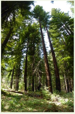
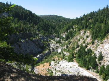
10 SAN VICENTE REDWOODS
11 PROJECT DESCRIPTION Cataloging, Monitoring and Managing Invasive Plant Species Document the process for replication Scope First property San Vicente Redwoods Initial species subset Existing data sets Broom, Pampas Grass, Clematis Property boundaries and features Streams, roads, gates, quarries, tunnels Infestations (shape files) Base map, DEM, photography Treatment history

12 PROJECT DESCRIPTION Phase One Requirements gathering Search and trial Architecture selection Phase Two DB design and implementation Toolset integration Initialization with existing and test data Sample analytics Phase Three Functional testing Process docs, User Guides, training Handoff and feedback
13 FUNCTIONAL REQUIREMENTS Flexible but controlled data sharing Scale to multiple properties Multiple users including partners In-field observations (mobile data collection device) Identify infested areas with species, spatial and temporal data Record treatment/management efforts Upload data Test, verify and edit data Sort and view data spatially
 over time Future extensions Add native plants of interest Add pristine areas, restoration areas, working forest areas Automate prioritization")
14 FUNCTIONAL REQUIREMENTS Data analysis Export data as required Sample reports Map by specific species Map species by specific location, area Map treatment areas, effort and supplies Map infestation(s) over time Future extensions Add native plants of interest Add pristine areas, restoration areas, working forest areas Automate prioritization process
15 SUPPORT AND TECHNICAL REQUIREMENTS Fit into existing GIS environments and budget Utilize standards where possible Mobile, desktop and online environments Varied user experience (experts to neophytes) Varied user loyalties (POST, partners, individuals, systems) Training and documentation User problem resolution Ongoing development and enhancements
16 CURRENT STATUS Requirements gathering Stakeholder engagement Specification document in progress Literature search/industry search Architecture considerations CalFlora Weed Manager field testing ongoing Mobile data collection app Large database of California invasive species Online viewer, maps and tables Data export for in-house analysis ESRI ArcGIS and Collector field testing ongoing ESRI Collector build your own app ArcGIS online for viewing Seamless data export for desktop analysis


17 CALFLORA OBSERVER PRO SAMPLES Images from the CalFlora Observer Pro User Guide

18 CALFLORA VIEWER SAMPLE SCREEN Image from the CalFlora web page

19 CALFLORA EXPORT SAMPLE Image from the CalFlora web page


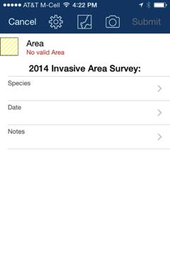
20 ESRI COLLECTOR SAMPLE SCREENS
21 ESRI COLLECTOR SERVICES

22 EXISTING INFESTATION DATA

23 EXISTING TREATMENT DATA
24 PROJECT OUTLINE AND PURPOSE Define a particular need within a non-profit land trust Cataloging, managing and monitoring invasive plant species San Vicente Redwoods Design and implement a GIS solution Database, mobile gathering, online viewing and desktop analysis CalFlora has many of the front end required attributes CalFlora can export data for analysis with POST s ESRI systems Create sample reports Document and handoff the system User Guides

25 SCHEDULE Phase One Ongoing Dec 2016 Phase Two Jan Feb 2016 Phase Three Mar Apr 2016 Presentation Conference TBD
26 SOURCES AND RESOURCES Big Creek Lumber CalFlora Information on wild California plants for conservation, education and appreciation Markegard Family Grass Fed Peninsula Open Space Trust preserve open space close to home Flieschmann, I. S. Placeworks, July 31, 2014, Summary of the San Vicente Redwoods Public Access Plan USDA Forest Service, No Date, A weed Managers Guide to Remote Sensing and GIS USDA Forest Service, 2013, National Strategic Framework for Invasive Species Management USDA Forest Service, No Date, Forest Health Protection Mapping and Reporting USDA Forest Service, No Date, Field Guide Invasive Plant Inventory, Monitoring and Mapping Protocol Thanks so far to Stewardship Volunteers including KellyRunyan and John Chamberlan SVR PM and RPF Nadia Hamey POST Stewardship Staff Daniel Olstein, Neal Sharma and Kara Caselas PSU guide Douglas Millar

27 THANKS. QUESTIONS? Dale Jantzen
Maryland Conservation Corps
 Maryland Conservation Corps Program Overview and Easement Project 1 Maryland Conservation Corps Began in 1984 as a Summer Conservation Corps for Youth In 1992 the program expanded to a 10 month program
Conservancy Mission. Leveraging GIS Technologies in Chesapeake Conservation and Restoration 10/17/2018
 Leveraging GIS Technologies in Chesapeake Conservation and Restoration Rachel Soobitsky Geospatial Project Manager Chesapeake Conservancy Conservation Innovation Center Kristin Kirkwood Executive Director
Land Trust of Santa Cruz County. Strategic Plan. July 2012 to June This is a public version of a more detailed internal plan.
 Land Trust of Santa Cruz County Strategic Plan July 2012 to June 2015 This is a public version of a more detailed internal plan. Over the next three years the Land Trust will pursue four critical strategies.
Before the meeting starts: Please circle the area your land trust works on the wall poster and note the land trust name
 Before the meeting starts: Please circle the area your land trust works on the wall poster and note the land trust name GIS in land conservation. Brian Hall brianhallconservation@gmail.com 10/3/2017 What
LIVING LANDS BIODIVERSITY GRANTS: INFORMATION AND APPLICATION. Due: January 16, 2009
 LIVING LANDS BIODIVERSITY GRANTS: INFORMATION AND APPLICATION Due: January 16, 2009 PURPOSE OF LIVING LANDS PROJECT Defenders of Wildlife s Living Lands project provides financial, technical and educational
ParcelMap BC Compiling a Parcel Fabric for the Province of British Columbia. Presented by: Ellen Styner (General Manager) and Wendy Amy (GIS Manager)
 and Wendy Amy (GIS Manager)") ParcelMap BC Compiling a Parcel Fabric for the Province of British Columbia Presented by: Ellen Styner (General Manager) and Wendy Amy (GIS Manager) Who is MNC? MNC is a geomatics engineering firm with
ParcelMap BC Compiling a Parcel Fabric for the Province of British Columbia Presented by: Ellen Styner (General Manager) and Wendy Amy (GIS Manager) Who is MNC? MNC is a geomatics engineering firm with
ParcelMap BC. Compiling a Parcel Fabric for the Province of British Columbia. WENDY AMY and ELLEN STYNER
 ParcelMap BC Compiling a Parcel Fabric for the Province of British Columbia WENDY AMY and ELLEN STYNER Who is MNC? Established in 1997, MNC is a geomatics engineering firm located in Calgary, Alberta.
Project Summary (from Proposal)
") Easygrants ID: 23603 National Fish and Wildlife Foundation NFWF/Legacy Grant Project ID: 1401.10.023603 LI Sound Futures Fund 2010 - Planning, Design, Etc. - Submit Final Programmatic Report (Activities)
Easygrants ID: 23603 National Fish and Wildlife Foundation NFWF/Legacy Grant Project ID: 1401.10.023603 LI Sound Futures Fund 2010 - Planning, Design, Etc. - Submit Final Programmatic Report (Activities)
Application Procedures for Easements or Rights of Way on City of Fort Collins Natural Areas and Conserved Lands March 2012
 Application Procedures for Easements or Rights of Way on City of Fort Collins Natural Areas and Conserved Lands March 2012 IMPORTANT NOTE: This document was created to accompany the City of Fort Collins
COASTAL CONSERVANCY. Staff Recommendation August 2, 2012 HARE CREEK BEACH COASTAL ACCESS TRAIL. Project No Project Manager: Lisa Ames
 COASTAL CONSERVANCY Staff Recommendation August 2, 2012 HARE CREEK BEACH COASTAL ACCESS TRAIL Project No. 08-001-02 Project Manager: Lisa Ames RECOMMENDED ACTION: Authorization to disburse up to $60,000
Cloud GIS Real Estate Management, Appraisal and Development Service USING ESRIs ARCGIS SERVER
 Cloud GIS Real Estate Management, Appraisal and Development Service USING ESRIs ARCGIS SERVER INFODIM: Was founded on 1992 and is internationally certified as a GIS company from D&B Dun & Bradstreet Global
Utility networks in Estonian Restrictions Information
 Utility networks in Estonian Restrictions Information System Mr. Priit Kuus Department of Land Cadastre priit.kuus@maaamet.ee +372 675 0843 Tallinn 2011 Restrictions: legal grounds The Constitution of
Using ArcGIS Server for National Property Information System
 Using ArcGIS Server for National Property Information System Shota Chachkhunashvili (National Agency of Public Registry, Georgia) Mikheil Tsiklauri (Geographic, Georgia) San Diego, 2008 About us National
Egyptian Nationwide Title Cadastre System
 Kholoud SAAD, Egypt Key words: Cadastre, Registration, Urban, Rural, National Cadastre, Automation, reengineering. SUMMARY With growing need for integrated information, Enterprise Solutions has become
Modernizing Land Administration Systems
 Presented at the FIG Congress 2018, May 6-11, 2018 in Istanbul, Turkey Modernizing Land Administration Systems B r e n t J o n e s P E, PLS E s r i Land Administration Systems GIS is the Technology Platform
Introduction to INRMP Implementation Options
 El Dorado County Integrated Natural Resources Management Plan Introduction to INRMP Implementation Options 1 Our approach to the options evaluation is based on the INRMP components as they are currently
Sample Baseline Documentation Report (BDR) Annotated Template for Environmentally Important Land
 Annotated Template for Environmentally Important Land") Sample Baseline Documentation Report (BDR) Annotated Template for Environmentally Important Land The baseline documentation report (BDR) provides a snap shot of the biophysical condition of a property
Sample Baseline Documentation Report (BDR) Annotated Template for Environmentally Important Land The baseline documentation report (BDR) provides a snap shot of the biophysical condition of a property
The Contribution of Forest Owners Associations for the Forest Cadastre Implementation. João Gaspar Ana Navarro Ferreira PORTUGAL
 The Contribution of Forest Owners Associations for the Forest Cadastre Implementation João Gaspar Ana Navarro Ferreira PORTUGAL Motivation Lack of forestry cadastre; Unify all FOAs databases with common
CLICK HERE TO KNOW MORE
 CLICK HERE TO KNOW MORE LANDS AND SURVEYS DEPARTMENT SABAH, MALAYSIA GEO-CADASTRE IN LAND ADMINISTRATION: SABAH S EXPERIENCE Sr Hj SAFAR B UNTONG, FISM, MRICS Director, Lands & Surveys Department Sabah,
Introduction. Management Strategies for Central Maritime Chaparral. Reasons for Protection
 Management Strategies for Central Maritime Chaparral by Tami Nakahara Introduction The central maritime chaparral community (CMC) in the Elkhorn Slough Watershed, North Monterey County, California is classified
Greene Land Trust. Balancing Sound Development and Effective Conservation
 Balancing Sound Development and Effective Conservation Comprehensive Approach The is dedicated to protecting the many places that make Greene County such a special place: Scenic vistas that inspired the
Conservation Partners Legacy Grant Application
 CPL Applications (Total to date: 129) Spreadsheet Conservation Partners Legacy Grant Application CPL1000084 Name and Contact Project Identifier: CPL1000084 Project Name: CREP Easement Invasive Species
Automated Land Development Applications
 Automated Land Development Applications AGENDA Yarra Valley Water Land Development Process GIS Automation Business Rules Engine Automated Spatial Analysis Questions.Encourage GIS community to embrace GIS
The GIS Behind Dakota County s FARMLAND AND NATURAL AREAS PROGRAM
 The GIS Behind Dakota County s FARMLAND AND NATURAL AREAS PROGRAM The Farmland and Natural Areas Program is a voluntary program in which Dakota County and other partners work with willing landowners to
Dakota County Farmland and Natural Areas Program. Lake Pepin TMDL May 31, 2007
 Dakota County Farmland and Natural Areas Program Lake Pepin TMDL May 31, 2007 Presentation Overview County Context FNAP Planning Process FNAP Implementation Integrating Conservation Efforts Parcel Development
New Technology for Cadastral Systems. Brent Jones, PE, PLS
 New Technology for Cadastral Systems Brent Jones, PE, PLS Benefits of Good Land Administration Key to addressing global challenges.. Secure Tenure Equitable Land and Property Taxation Support for Government
Good Land Governance for the 2030 Agenda
 Good Land Governance for the 2030 Agenda Addis Ababa, Ethiopia 20-22 April, 2014 Role of Geospatial Information in Good Land Policy and Governance Oumar Sylla UN-Habitat/GLTN oumar.sylla@unhabitat.org
Wood River Land Trust Staff Report
 Wood River Land Trust Staff Report Date: July 9, 2014 To: Board of Directors From: Staff, Keri York Regarding: MacConnell Agricultural Lands Easement Action Item Action Item: The item for consideration
Wildlife Habitat Conservation and Management Program
 EXHIBIT 1 PC-2015-4106 ODFW Guide Wildlife Habitat Conservation and Management Program Manual for Counties and Cities Oregon Department of Fish and Wildlife March 2006 Table of Contents 1. Introduction
Using Easements to Conserve Biodiversity. Jeff Lerner Defenders of Wildlife
 Using Easements to Conserve Biodiversity Jeff Lerner Defenders of Wildlife jlerner@defenders.org Northeast LTA June 10, 2006 Defenders of Wildlife Mission: to protect native wild animals and plants in
Land Conservation Agreements Project Guidance
 Land Conservation Agreements Project Guidance Stakeholder Informed OTHER OPTIONS Introduction Enhanced or permanent protection of corporate lands through land conservation agreements means that companies
Land Transaction Procedures Approved July 17, 2012
 Land Transaction Procedures Approved July 17, 2012 Purpose: The Greenbelt Land Trust (GLT) acquires fee title or conservation easements for lands to fulfill its mission to conserve and protect in perpetuity
LLC & MLLC Property Bismark Meadows Bonner County, Idaho
 Vital Ground Property Management Plan LLC & MLLC Property Bismark Meadows Bonner County, Idaho December 10, 2009 (updated 2/12/13) Ryan Lutey The Vital Ground Foundation Building T-2, Fort Missoula Road
Environment and Natural Resources Trust Fund (ENRTF) M.L Work Plan
 M.L Work Plan") Environment and Natural Resources Fund (ENRTF) M.L. 2015 Work Plan Date of Report: May 14, 2015 Date of Next Status Update Report: February 1, 2016 Date of Work Plan Approval: Project Completion Date:
Environment and Natural Resources Fund (ENRTF) M.L. 2015 Work Plan Date of Report: May 14, 2015 Date of Next Status Update Report: February 1, 2016 Date of Work Plan Approval: Project Completion Date:
Presented by: Stewart Information International, Inc. Jack McKenna
 Presented by: Stewart Information International, Inc. Jack McKenna Held at the: 2007 ESRI Survey & Engineering GIS Summit San Diego Convention Center San Diego, California June 16-19, 2007 Integrating
Horse Gulch Management Plan Final Draft: April 18, 2013
 I. INTRODUCTION This Plan provides a framework for the sound stewardship of the City of Durango Horse Gulch open space area. The Plan includes baseline information regarding the area, management objectives
Claudia Stuart, Williamson Act Program Manager and Nick Hernandez, Planning Intern
 Land Conservation (Williamson) Act Advisory Committee STAFF REPORT September 15, 2014 Prepared by: Claudia Stuart, Williamson Act Program Manager and Nick Hernandez, Planning Intern Subject: Discussion:
Esri Middle East and Africa User Conference. December Abu Dhabi, UAE. Land Administration. Mark Baker
 Esri Middle East and Africa User Conference December 10 12 Abu Dhabi, UAE Land Administration Mark Baker Our Agenda 0900 0930 Welcome Mark Baker, Esri 0930 1030 New Directions The New Addressing System
GIS After the Conversion. Mid West ESRI Utility Users Group 2007
 GIS After the Conversion Mid West ESRI Utility Users Group 2007 Presented by: A Jeffrey A. Grussing Leader, GIS Development jgrussing@usgweb.com Background Kandiyohi Power Cooperative Worked two years
Shaping the Cadastral Infrastructure for a Digital Future
 DEPARTMENT OF LANDS PLANNING and the ENVIRONMENT Shaping the Cadastral Infrastructure for a Digital Future Craig Sandy Director Surveys Surveyor General Survey Branch NT Australia Digital Cadastral Databases
PROJECT SCORING GUIDANCE. Introduction: National Proiect Selection:
 FOREST LEGACY PROGRAM PROJECT SCORING GUIDANCE Introduction: This document provides guidance to the National Review Panel on how to score individual Forest Legacy Program (FLP) projects, including additional
Validation Checklist. Date submitted: How to use this check-list. Ecosystem Credit Accounting System. Version 1.1&2. Project Information
 Ecosystem Credit Accounting System Version 1.1&2 Last updated April 21, 2017 Validation Checklist Date submitted: Project Information Project Name Trading Area Name Trading Area Type (e.g., TMDL, TNC Ecoregion)
FARMLAND AMENITY PROTECTION. A Brief Guide To Conservation Easements
 FARMLAND AMENITY PROTECTION A Brief Guide To Conservation Easements The purpose of this guide is to help landowners access their land amenity value and to provide direction to be compensated for this value.
Fit-for Purpose Approaches to Land Administration
 Fit-for Purpose Approaches to Land Administration Brent Jones, PE, PLS Global Manager, Casastre/Land Records bjones@esri.com Land Administration GIS is the platform for land administration Land administration
Theme Strategic Plan for Cadastral Theme
 Theme Strategic Plan for Cadastral Theme Bureau of Land Management Cadastral Survey Federal Geographic Data Committee (FGDC) 2017 2021 April 2017 - Progress and Update Cadastral Theme Implementation Plan
Carbon Projects & Conservation Easements
 Carbon Projects & Conservation Easements California Council of Land Trusts Conservation Law Forum November 16, 2016 Misti Schmidt mschmidt@coblentzlaw.com Jim Clark jimclark@ncrm.com Agenda 1. Overview
APRIL 30, ILL. ADM. CODE 2580 CH. I, SEC. 2580
 TITLE 17: CONSERVATION CHAPTER I: DEPARTMENT OF NATURAL RESOURCES SUBCHAPTER f: ADMINISTRATIVE SERVICES PART 2580 CONSERVATION STEWARDSHIP PROGRAM Section 2580.10 Definitions 2580.20 Eligibility 2580.30
LRIMS Cadastre Module
 LRIMS Cadastre Module User Requirements and Functionality (Seychelles Case Study) John Latham, NRL Renato Cumani, NRL Luigi Simeone, NRL Summary Background User Requirements Business Model Application
WESTERLY MUNICIPAL LAND TRUST RULES AND REGULATIONS
 Trustees; Les Crandall, Chairman James Federico III Giorgio Gencarelli Gail Mallard, Secretary Nancy Martin Lise Mayers Richard Silva WESTERLY MUNICIPAL LAND TRUST WESTERLY MUNICIPAL LAND TRUST RULES AND
Bureau of Land Management MAPPS Federal Update Donald Buhler Cadastral, Lands, and Realty Management April 14, 2015
 Bureau of Land Management MAPPS Federal Update Donald Buhler Cadastral, Lands, and Realty Management April 14, 2015 Division of Cadastral, Lands and Realty Management 1 BLM Mission Manages 247 million
Conservation Easement Stewardship
 Conservation Easements are effective tools to preserve significant natural, historical or cultural resources. Conservation Easement Stewardship Level of Service Standards March 2013 The mission of the
2018 Highlands Region Land Preservation Status Report
 2018 Highlands Region Land Preservation Status Report Highlands Development Credit (HDC) properties (l to r): Tewksbury Township, Hunterdon County; Mount Olive, Morris County; Independence Township, Warren
Columbia Land Trust is seeking a Conservation Lead to join its passionate team!
 Job Title: Conservation Lead Salary Range: $54,000 - $64,000 Location: Astoria Office (with regular travel to the Vancouver Office) Reports To: Conservation Director Appl. Deadline: Open until filled -
New Models for Property Data Verification and Valuation
 New Models for Property Data Verification and Valuation for 2006 IAAO Councils and Sections Joint Seminar May 9-11, 2006 Charleston, South Carolina Presented by George Donatello, CMS Principal Consultant
Summary of New Hampshire ANS Laws*
 Summary of New Hampshire ANS Laws* NH statutes: NH statutes: http://www.gencourt.state.nh.us/rsa/html/indexes/search.html Policy and Agency Powers: 1) Powers and Duties of the Commissioner: The Department
Systematic Land Information Management (SLIM)
") Systematic Land Information Management (SLIM) By Mr. Jukka Nieminen Jaakko Pöyry Infra Soil and Water Ltd. Expert Group Meeting on Secure Land Tenure: New Legal Frameworks and Tools Nairobi 12 November
Systematic Land Information Management (SLIM) By Mr. Jukka Nieminen Jaakko Pöyry Infra Soil and Water Ltd. Expert Group Meeting on Secure Land Tenure: New Legal Frameworks and Tools Nairobi 12 November
11 Teranet Easement Mapping Data Acquisition
 Clause 11 in Report No. 18 of Committee of the Whole was adopted, without amendment, by the Council of The Regional Municipality of York at its meeting held on November 19, 2015. 11 Teranet Easement Mapping
Forestry and Forested Land Protection Grant Program for Anne Arundel County
 Forestry and Forested Land Protection Grant Program for Anne Arundel County www.chesapeakebaytrust.org / 410-974-2941 Introduction This program is designed to increase acres of forest and protected forested
CONSERVATION EASEMENT INCLUDING MITIGATION
 After recording return to: GRANTOR: GRANTEE: GRANTEE (Trustee): LEGAL DESCRIPTION: TAX PARCEL I.D. #: REFERENCE # s: WHATCOM COUNTY N/A CONSERVATION EASEMENT INCLUDING MITIGATION This grant of a conservation
Saskatchewan Farmland Ownership
 Saskatchewan Farmland Ownership Joint presentation to the Ministry of Agriculture by: Ducks Unlimited Canada Nature Conservancy of Canada Saskatchewan Wildlife Federation June 11, 2015 DUC Saskatchewan
Updated - A Report on the County of Arlington s Existing and Possible Urban Tree Canopy
 Updated - A Report on the County of Arlington s Existing and Possible Urban Tree Canopy Key Terms UTC: Urban tree canopy (UTC) is the layer of leaves, branches, and stems of trees that cover the ground
Conservation Easement Best Management Practices
 Conservation Easement Best Management Practices Natural Resources Department April 2013 The mission of the Larimer County Natural Resources Department is to establish, protect and manage significant regional
Baseline Documentation and Inventory Protocol, Version 2
 Rhode Island Conservation Stewardship Collaborative Baseline Documentation and Inventory Protocol, Version 2 September 2014 Carol Lynn Trocki Conservation Biologist Scott Ruhren, Ph.D. Senior Director
Conservation Easement Stewardship
 Conservation Easement Stewardship Anne Murphy Minnesota Land Trust February 24, 2011 Overview for Today 1. Introduction 2. Stewardship Obligations and Costs 3. Voluntary Easement Compliance 4. Cost Analysis
State of Washington Project Luke Rogers, University of Washington March 2010
 State of Washington Project Luke Rogers, University of Washington March 2010 Rural Technology Initiative (RTI) developed an online tutorial on how to use the Washington State Parcel and Forestland Databases
TransNet Environmental Mitigation Program: Land Acquisition and Restoration Process and Criteria
 TransNet Environmental Mitigation Program: Land Acquisition and Restoration Process and Criteria On September 26, 2008, the San Diego Association of Governments Board of Directors (BOD) approved the attached
Siskiyou Land Trust. Strategic Plan Update
 Siskiyou Land Trust Strategic Plan Update 2018-2023 Issued by the Board of Directors of Siskiyou Land Trust, May 2018 Our Mission: The Siskiyou Land Trust is dedicated to long-term stewardship of agricultural,
QUESTIONNAIRE. 1. Authorizing statute(s) citation West Virginia Code and 11-1C-4(d)
 citation West Virginia Code and 11-1C-4(d)") QUESTIONNAIRE (Please include a copy of this form with each filing of your rule: Notice of Public Hearing or Comment Period; Proposed Rule, and if needed, Emergency and Modified Rule.) DATE: 6/8/15 TO:
QUESTIONNAIRE (Please include a copy of this form with each filing of your rule: Notice of Public Hearing or Comment Period; Proposed Rule, and if needed, Emergency and Modified Rule.) DATE: 6/8/15 TO:
Real Estate Administration at the Vancouver Port Authority (VPA) Presentation by Ron McMillan - GIS/LIS Coordinator December 13, 2004
 Presentation by Ron McMillan - GIS/LIS Coordinator December 13, 2004") Real Estate Administration at the Vancouver Port Authority (VPA) Presentation by Ron McMillan - GIS/LIS Coordinator December 13, 2004 Introduction Overview of the Vancouver Port Authority (VPA) How CAD
Real Estate Administration at the Vancouver Port Authority (VPA) Presentation by Ron McMillan - GIS/LIS Coordinator December 13, 2004 Introduction Overview of the Vancouver Port Authority (VPA) How CAD
Planning with Conservation Easements
 Planning with Conservation Easements Succession, Tax & Estate Planning Issues & Ideas for Legacy Land October 23, 2015 Intergenerational Planning for Legacy Land Begin with the end in mind. Your goals
A CADASTRAL GEODATA BASE FOR LAND ADMINISTRATION USING ARCGIS CADASTRAL FABRIC MODEL A CASE STUDY OF UWANI ENUGU, ENUGU STATE, NIGERIA
 A CADASTRAL GEODATA BASE FOR LAND ADMINISTRATION USING ARCGIS CADASTRAL FABRIC MODEL A CASE STUDY OF UWANI ENUGU, ENUGU STATE, NIGERIA BY Ndukwu, Raphael. Ike Department of Geoinformatics & Surveying University
THE COUCHICHING CONSERVANCY LAND STEWARDSHIP POLICY. As approved by the Board, April 30, 2007
 THE COUCHICHING CONSERVANCY LAND STEWARDSHIP POLICY As approved by the Board, April 30, 2007 When one tugs at a single thing in nature, he finds it attached to the rest of the world. John Muir This policy
I GIS market of Korea.
 I. GIS market of Korea National Informationization Base Preparing National Informationization Driving The 1st National basic computer network basic plan(1987~1991) GIS Base Creating The 1st National geographic
Lessard Sams Outdoor Heritage Council
 Lessard Sams Outdoor Heritage Council MEMO: Agenda Item # 10 DATE: December 11, 2014 SUBJECT: PRESENTER: 2015 Legislative Appropriation Recommendation Bill Heather Koop, LSOHC staff Background: On October
Bureau of Land Management
 Bureau of Land Management MAPPS Federal Update Donald Buhler Cadastral, Lands, and Realty Management April 1, 2014 Division of Cadastral, Lands and Realty Management 1 BLM Mission Manages 247 million surface
Designing for transparency and participation in the Hellenic Cadastral Project
 Designing for transparency and participation in the Hellenic Cadastral Project Dr. Dimitris Rokos Director of Planning and Investments, Hellenic National Cadastre and Mapping Agency S.A. Table of Contents
Pit-McCloud River Watershed
 Pit-McCloud River Watershed Agricultural Uses...Much existing data regarding McArthur Swamp stocking rates and timing is available through Larry Fererro, Shasta County UC Davis Cooperative Extension Office.
National Spatial Data Infrastructure development in Republic of Macedonia
 National Spatial Data Infrastructure development in Republic of Macedonia Sonja Dimova, state advisor for geomatics AGENCY FOR REAL ESTATE CADASTRE September 6-th, 2017, Strasbourg AREC competence for
Mission Planning for a GPS Control Survey Using ESRI ArcMap. August 8, 2004 Mickie Warwick, PLS
 Mission Planning for a GPS Control Survey Using ESRI ArcMap August 8, 2004 Mickie Warwick, PLS Using ArcMap for GPS Mission Planning Surveyors are not tapping into the benefits that can be derived from
Innovative approaches to Land Governance Programme management; a Contractors View. Clive English & Owen Edwards
 Innovative approaches to Land Governance Programme management; a Contractors View Clive English & Owen Edwards 1 Structure of the Presentation The Programmes and Issues in Land Governance Principal Elements
Moriah Ranch Request for Proposal For Farm and Ranch Management Lease
 Moriah Ranch Request for Proposal For Farm and Ranch Management Lease PURPOSE OF REQUEST The Office of State Lands and Investments (OSLI) is seeking a long term farm and ranch management lease on the Moriah
Mineral Resources Authority (MRA) FlexiCadastre Papua New Guinea
 FlexiCadastre Papua New Guinea") Mineral Resources Authority (MRA) FlexiCadastre Papua New Guinea Louie Kawale Mining Management System Administrator Margaret Aulda Senior Technical Assessment Officer Nancy Wafiwa Assessment Geologist
Mineral Resources Authority (MRA) FlexiCadastre Papua New Guinea Louie Kawale Mining Management System Administrator Margaret Aulda Senior Technical Assessment Officer Nancy Wafiwa Assessment Geologist
MITIGATION POLICY FOR DISTRICT-PROTECTED LANDS
 MITIGATION POLICY FOR DISTRICT-PROTECTED LANDS Approved by the District Board of Directors on July 18, 2017 The following Mitigation Policy is intended to inform the evaluation of environmental mitigation-related
An Overview of the eplan Journey with a Focus on the Victorian eplan 2025 Roadmap Dr Hamed Olfat
 An Overview of the eplan Journey with a Focus on the n eplan 2025 Roadmap Dr Hamed Olfat eplan Coordinator Land Use Chairman of Technical Committee ICSM eplan Working Group Outline eplan Overview ICSM
Antelope Ridge Wind Farm Habitat Mitigation Plan November 2011
 Antelope Ridge Wind Farm Habitat Mitigation Plan November 2011 I. Introduction The Antelope Ridge Wind Farm will be constructed in two phases, in the locations as shown on the attached map, Exhibit A.
Jackson County Residental Market Trends. November Pending Sales New Listings
 Jackson County Residental Market Trends November 2017 Pending Sales..2 New Listings..3 Overall activity trends are not a measure of pricing or value for individual properties. Small Sampling sizes can
Use of data in Ukraine for sustainable economic growth. Oleksandr Maliuk State Service of Ukraine for Geodesy, Cartography and Cadastre
 Use of data in Ukraine for sustainable economic growth Oleksandr Maliuk State Service of Ukraine for Geodesy, Cartography and Cadastre Kehl, 2017 Content of the presentation Ukraine & StateGeoCadastre:
Property Profile Data Systems
 Property Profile Data Systems Michael Schramm, Director of IT and Research Research Associate, Center on Urban Poverty and Community Development, Case Western Reserve University 1 Today s outline Introduce
Real Solutions for the. Real Estate Industry.
 Real Solutions for the Real Estate Industry www.ziplogix.com The smart choice to empower your business Since 1991, ziplogix has been delivering software and web applications that significantly improve
RUV Registro Único de Vivienda
 RUV Registro Único de Vivienda (National Housing Registry) Technology for a Sustainable Housing Policy March 7, 2013 RUV Key Events - Timeline Infonavit announces creation of National Housing Registry
The Strategic Plan can be viewed by clicking this link.
 What is the purpose of the Land Information Office? Many of Brown County's most basic services rely on accurate and up-to-date land information. Emergency response, resource conservation, infrastructure
Oxbow Park and Preserve Management Plan
 Oxbow Park and Preserve Management Plan INTRODUCTION This Plan establishes a framework for the sound stewardship of Oxbow Park and Preserve. Policies, management objectives and envisioned future improvements
SUBCHAPTER 59F CONSERVATION RESERVE ENHANCEMENY ENHANCEMENT PROGRAM (CREP) STATE PORTION OF THE PROGRAM
 STATE PORTION OF THE PROGRAM") SUBCHAPTER 59F CONSERVATION RESERVE ENHANCEMENY ENHANCEMENT PROGRAM (CREP) STATE PORTION OF THE PROGRAM SECTION.0100 - CONSERVATION RESERVE ENHANCEMENT PROGRAM (CREP) -- STATE PORTION OF THE PROGRAM 02
SUBCHAPTER 59F CONSERVATION RESERVE ENHANCEMENY ENHANCEMENT PROGRAM (CREP) STATE PORTION OF THE PROGRAM SECTION.0100 - CONSERVATION RESERVE ENHANCEMENT PROGRAM (CREP) -- STATE PORTION OF THE PROGRAM 02
Private Land Conservation: Conservation Easements. Matt Singer Land Stewardship Manager
 Private Land Conservation: Conservation Easements Matt Singer Land Stewardship Manager Galveston Bay Foundation Mission: To preserve, protect, and enhance the natural resources of the Galveston Bay estuarine
LADM-based Crowdsourced 3D Cadastral Surveying Potential and Perspectives
 National Technical University Of Athens School of Rural and Surveying Engineering LADM-based Crowdsourced 3D Cadastral Surveying Potential and Perspectives Maria Gkeli, Surveying Engineer, PhD student
Corte Madera Marsh Restoration Project Update
 Corte Madera Marsh Restoration Project Update Building and Operating Committee Agenda Item No. 5 August 25, 2016 Photo credit: WRA Background of Site 1. 72 acre parcel carved out of larger property acquired
DESCRIPTION OF A LAND TRUST
 DESCRIPTION OF A LAND TRUST What is a land trust? Land trusts are non-profit organizations that work hand-in-hand with landowners to protect our valuable natural resources. Land trusts have become increasingly
COASTAL CONSERVANCY. Staff Recommendation January 18, Carmel River Parkway Acquisitions. File No Project Manager: Trish Chapman
 COASTAL CONSERVANCY Staff Recommendation January 18, 2006 Carmel River Parkway Acquisitions File No. 06-104 Project Manager: Trish Chapman RECOMMENDED ACTION: Authorization to disburse up to $3,500,000
The Effective Analyst: From Research to Execution. Contents are subject to change. For the latest updates visit
 The Effective Analyst: From Research to Page 1 of 8 Why Attend Solving problems in the business world is essential to keeping things moving along smoothly. While problems differ in complexity, almost all
RECITALS. B. WHEREAS, Ranch, its successors and assigns, are referred to in the Easement as the Grantor ; and
 Basic Components of Management Plans Associated with Conservation Easement Acquisitions Where A Land Trust Or other third party Is the Grantee April 17, 2012 Key: Text in normal font, without highlight,