Real Estate Administration at the Vancouver Port Authority (VPA) Presentation by Ron McMillan - GIS/LIS Coordinator December 13, 2004
|
|
|
- Poppy Bryant
- 6 years ago
- Views:
Transcription

1 Real Estate Administration at the Vancouver Port Authority (VPA) Presentation by Ron McMillan - GIS/LIS Coordinator December 13, 2004
2 Introduction Overview of the Vancouver Port Authority (VPA) How CAD and GIS are used How VPA uses GIS to administer Real Estate Q & A
3 History of the VPA Operated informally as a harbour Vancouver Harbour Commission Six Harbours Agreement established the Port of Vancouver as a Federal Port National Harbours Board Vancouver Port Corporation Vancouver Port Authority
4 About the VPA Areas Proprietary jurisdiction of 65 sq km Navigational jurisdiction of 392 sq km Length of Coastline Proprietary 161 km Navigational 247 km

5 VPA Navigational and Proprietary Jurisdictions
6 About the VPA Bordering Municipalities: Vancouver Burnaby District of North Vancouver Belcarra City of North Vancouver Delta District of West Vancouver Port Moody Other Province of BC (east side of Indian Arm)
7 About the Port of Vancouver #1 in Canada in Total Cargo handled #3 on West Coast full foreign containers Cruise Industry contributes $508 million to regional economies Create 27,500 direct job across Canada $620 million in taxes to governments $55.5 million in PILT and property tax to 8 municipalities
8 How the VPA Operates Canada Marine Act, Payments in Lieu of Taxes Act and others federal laws define how the VPA operates. VPA operates as an Agent of Her Majesty in right of Canada and reports to the federal Minister of Transport. Canada Marine Act gives VPA the authority to lease or licence Federal Real Property in it s defined jurisdiction. VPA s Letters Patent issued in terms of the Canada Marine Act, identifies VPA s jurisdiction.
9 Management of VPA Land Records VPA does not subscribe to the Provincial Land Titles Office (LTO) for recording leases or licences*. Some areas within the VPA jurisdiction are registered in the LTO, but those boundaries often do not correspond to the lease or licence parcels. VPA operates it s own private land registry system, using a combination of GIS and LIS (NovaLIS) systems. *With the exception of residential waterfront licences
10 Management of VPA Land Records In effect, VPA operates two distinct boundary systems. LTO Parcels identified by a unique number PID (e.g.: ) VPA Parcels identified by a unique number LID (e.g.: )

11 VPA parcels and LTO registered parcels
12 Uses of CAD at VPA Use AutoDesk: Map Raster Design Land Desktop Allows compatibility with our contractors, surveyors, consultants and tenants.
13 Uses of CAD at VPA Real Estate Mapping, cadastral parcels, surveys, VPA parcels Engineering Structures, utilities, soundings Planning Land use

14 AutoDesk Examples
15 AutoDesk Examples

16 AutoDesk Examples

17 AutoDesk Examples
18 CAD to GIS All Design work done in CAD E.g.: Negotiations with tenants to lease/licence areas Data added to DWG source files: Finalized VPA agreement & unoccupied parcels Assigned unique LID number by our NovaLIS system known as PORTfolio Current and historical parcels Current mapping and provincial cadastral information
19 CAD to GIS Source DWG files contain: Object data Topology Database (MS SQL Server) Link templates
20 CAD to GIS Source DWG files are the basis of VPA s GIS Source DWG files are: Queried into other CAD files Used in design work in CAD Exported out to use in ESRI SHP files
21 CAD to GIS Types of Source DWG data Agreements VPA lease/licence agreements, unoccupied property Cadastral lots, easements, SROW, district lots, VPA, Harbour Headline, municipal, indian reserves, native land claims Natural Environment land, water, bathymetry, reclaimed land Spatial Framework - monuments
22 CAD to GIS Types of GIS data (continued) Infrastructure electrical, water, sewer, telephone, fibre, communications, gas, hydro, structures, road, rail Socio-Economic electoral districts World Data Canada, USA, Mexico, Europe, World
23 GIS Systems SHP files used in a number of VPA systems Various projects PORTfolio ArcView 3.2a + NovaLIS Land Titles Framework Maps on Request ArcIMS application
24 Real Estate GIS Projects Maps to better utilize Port Real Estate Maps to provide information on taxation
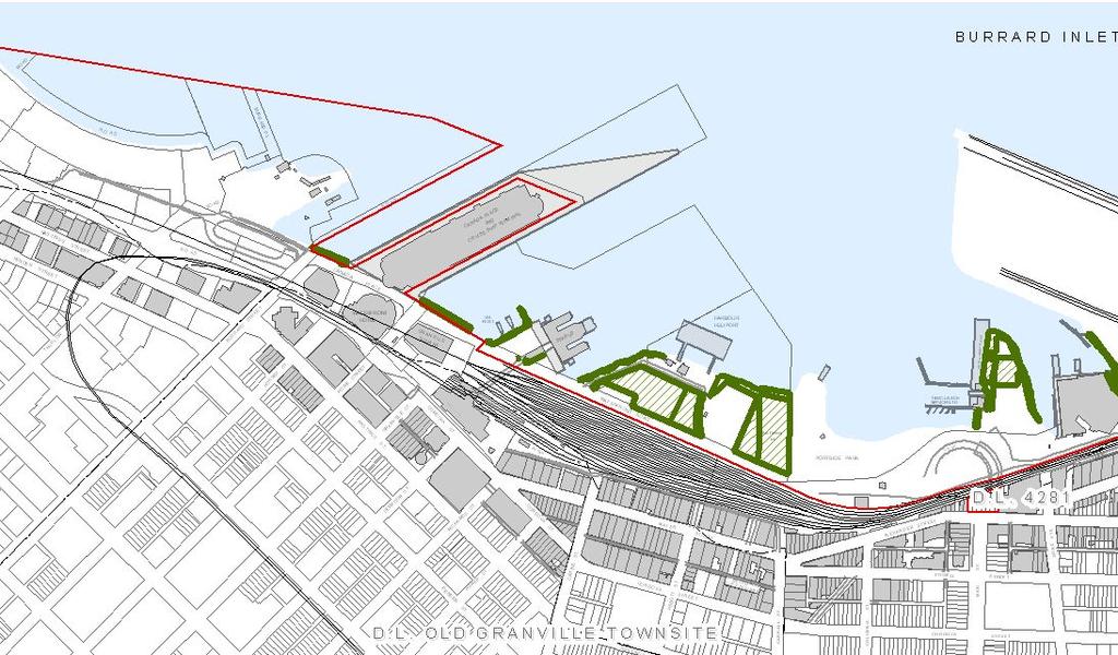
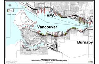
25 Unoccupied Land Areas

26 Strategic planning for future growth - Map

27 Strategic planning for future growth - Report

28 PILT Map for Delta
29 Real Estate Application - Maps on Request (MOR) ESRI ArcIMS application Used by all VPA staff Only system at VPA that uses all available GIS data

30 Vancouver Port Authority Maps on Request

31 Maps on Request Query s

32 Vancouver Port Authority Maps on Request Query selection of an agreement

33 Maps on Request Review LID parcel and relevant utilities
34 Real Estate Application - PORTfolio Parcel centric system (Land Information System) Contains information relating to: VPA Parcels LID numbers Agreements Contacts Environment GIS

35 PORTfolio Parcel Viewer
36 PORTfolio Parcel Viewer Various tabs containing LID information

37 PORTfolio Map Viewer

38 PORTfolio Parcel Viewer
39 Real Estate Administration at the Vancouver Port Authority (VPA) GIS used in a number of Real Estate related systems Tool used for administration of VPA Real Estate assets Our systems are flexible and they will continue grow with the GIS in the future. Questions?
Utility networks in Estonian Restrictions Information
 Utility networks in Estonian Restrictions Information System Mr. Priit Kuus Department of Land Cadastre priit.kuus@maaamet.ee +372 675 0843 Tallinn 2011 Restrictions: legal grounds The Constitution of
ParcelMap BC Compiling a Parcel Fabric for the Province of British Columbia. Presented by: Ellen Styner (General Manager) and Wendy Amy (GIS Manager)
 and Wendy Amy (GIS Manager)") ParcelMap BC Compiling a Parcel Fabric for the Province of British Columbia Presented by: Ellen Styner (General Manager) and Wendy Amy (GIS Manager) Who is MNC? MNC is a geomatics engineering firm with
ParcelMap BC Compiling a Parcel Fabric for the Province of British Columbia Presented by: Ellen Styner (General Manager) and Wendy Amy (GIS Manager) Who is MNC? MNC is a geomatics engineering firm with
Online Cadastre and Tantalis GATOR
 Online Cadastre and Tantalis GATOR Online Cadastre Free, public online access to BC Crown land cadastral information and other geographic data LTSA is responsible for maintenance of and enhancements to
Crown Land Use Operational Policy: Land and Management Transfers. Summary of Changes:
 APPROVED AMENDMENTS: Effective Date Briefing Note /Approval Summary of Changes: June 1, 2011 BN 175892 Policy and Procedure update to reflect reorganization of resource ministries April 2011 FILE: 11730-000
First Nations Land Registry
 First Nations Land Registry Making Sense of the ILRS Steven Patterson, Sitka Geomatics Inc. www.sitkageo.com Land Titles a brief history Land titles were traditionally managed within the community, and
Coastal Shore Jurisdiction in British Columbia
 ISSUE SHEET October 2009 Coastal Shore Jurisdiction in British Columbia Ju ris dic tion: the power, right and authority to interpret and apply the law. (Merriam Webster on-line) Who s in charge of coastal
The Multipurpose Marine Cadastre A Tool for Planning & Decision Making in the Marine Environment
 The Multipurpose Marine Cadastre A Tool for Planning & Decision Making in the Marine Environment Christine Taylor Minerals Management Service (MMS) Brian Smith NOAA Coastal Services Center Maurice Hill
Overview 7/6/2016. Agenda. Introduction to ParcelMap BC LGMA Annual Conference Nanaimo, BC. ParcelMap BC Primary Goal
 Agenda Overview ParcelMap BC Primary Goal ParcelMap BC Key Benefits ParcelMap BC Advisory Committee BC Assessment Grant Program Introduction to ParcelMap BC LGMA Annual Conference Nanaimo, BC Mike Thomson
Using ArcGIS Server for National Property Information System
 Using ArcGIS Server for National Property Information System Shota Chachkhunashvili (National Agency of Public Registry, Georgia) Mikheil Tsiklauri (Geographic, Georgia) San Diego, 2008 About us National
Integrating SAS and Geographic Information Systems for Regional Land Use Planning
 Integrating SAS and Geographic Information Systems for Regional Land Use Planning ABSTRACT Bill Bass, Houston-Galveston Area Council, Houston, Tx The Houston-Galveston Area Council (H-GAC) provides regional
Massive Collection of Cadastral Data in Greece Using Web-enabled GIS Technologies
 Massive Collection of Cadastral Data in Greece Using Web-enabled GIS Technologies Lefteris LYKOUROPOULOS and George MOURAFETIS, Greece Key words: Cadastre, Web services, applications, GIS, data collection
Shoowahtlans Indian Reserve No. 4 Metlakatla
 Land Description for Shoowahtlans Indian Reserve No. 4 Metlakatla British Columbia Prepared under First Nations Land Management (S.C. 1999, C.24) Prepared on: October 7 th, 2015 October 7, 2015 Table of
Date: April 15, 2016 Meeting Date: May 6, Park for Other Land to be used for Park Purposes Bylaw No. 1233, 2016 ;
 Section G 1.1 To: From: Regional Parks Committee Renato Jadrijev, Senior Property Negotiator, Financial Services Chris Plagnol, Director, Board and Information Services/Corporate Officer, Legal and Legislative
ParcelMap BC. Compiling a Parcel Fabric for the Province of British Columbia. WENDY AMY and ELLEN STYNER
 ParcelMap BC Compiling a Parcel Fabric for the Province of British Columbia WENDY AMY and ELLEN STYNER Who is MNC? Established in 1997, MNC is a geomatics engineering firm located in Calgary, Alberta.
Roles, Responsibilities and Relationships About MPAC Property Assessment in Ontario Updates to Assessment Values in Year Products and Services Role
 Roles, Responsibilities and Relationships About MPAC Property Assessment in Ontario Updates to Assessment Values in Year Products and Services Role of Municipal Relations Outreach Initiatives 2012 Assessment
GOVERNMENT. Case Study Ville de Trois Rivières streamlines property assessment
 GOVERNMENT Case Study Ville de Trois Rivières streamlines property assessment GIS-generated parcel basemap provides powerful visualization & analysis capabilities With a population of just over 130,000,
Land Tenure and Geospatial Data and Technology
 Land Tenure and Geospatial Data and Technology Ioana Bouvier E3/Land and Urban, USAID Senior Geospatial Analyst January 23, 2018 January 23, 2018 1 OUTLINE 1. Overview of geospatial data and technology
Fee Schedule ACCOUNT HOLDERS
 West Coast Title Search Ltd. We take pride in our work Fee Schedule ACCOUNT HOLDERS Effective April 7, 2015 Yes, We E-File! Visit us on the web and register for our online service forms at: www.wcts.com
Estonian e-cadastre as basis for efficient land management
 Estonian e-cadastre as basis for efficient land management Priit Kuus Estonian Land Board November 14, 2017 Tallinn Scope of data Cadastral parcels (as of October 2017) 693 026 cadastral parcels, i.e.
NEW DEVELOPMENTS IN THE REAL PROPERTY REGISTER AND CADASTRE IN LITHUANIA
 NEW DEVELOPMENTS IN THE REAL PROPERTY REGISTER AND CADASTRE IN LITHUANIA Jaunius Grigas E-mail: jaunius.grigas@registrucentras.lt Verona, 2008 FUNCTIONS OF STATE ENTERPRISE CENTRE OF REGISTERS Registration
Smart Infrastructure Benefits and Key Players from a Global Perspective
 Smart Infrastructure Benefits and Key Players from a Global Perspective Spatial@gov 2010 October 5-7 Canberra Jude Wallace and Abbas Rajabifard Centre for Spatial Data Infrastructures and Land Administration
Understanding the Consent Application Process
 Understanding the Consent Application Process Your Step-By-Step Guide for Consent-Granting Authorities 1 2 3 4 5 6 7 8 9 10 11 Section 53 of the Planning Act ontario.ca/municipallearning Understanding
City of Surrey s Digital Plan Submission Process
 City of Surrey s Digital Plan Submission Process Cadastral Update Karen Stewart, B.Tech. (GIS) Spatial Information Manager Peter Mueller, B.C.L.S., C.L.S. Survey Manager City of Surrey, British Columbia,
Egyptian Nationwide Title Cadastre System
 Kholoud SAAD, Egypt Key words: Cadastre, Registration, Urban, Rural, National Cadastre, Automation, reengineering. SUMMARY With growing need for integrated information, Enterprise Solutions has become
Esri Middle East and Africa User Conference. December Abu Dhabi, UAE. Land Administration. Mark Baker
 Esri Middle East and Africa User Conference December 10 12 Abu Dhabi, UAE Land Administration Mark Baker Our Agenda 0900 0930 Welcome Mark Baker, Esri 0930 1030 New Directions The New Addressing System
Who we are? MIS GIS. Cadastral Data Management System in Turkey. View from MIS. View from GIS. Dr. Emin Bank MIS? GIS? IT?
 Cadastral Data Management System in Turkey Dr. Emin Bank ebank@islem.com.tr Who we are?? View from? Or? View from Nowadays and are getting closer fastly 1 Viewing from is changing Viewing from is changing
Presented at the FIG Congress 2018, May 6-11, 2018 in Istanbul, Turkey
 Presented at the FIG Congress 2018, May 6-11, 2018 in Istanbul, Turkey 5 Bibliometric Analysis of Articles Presented Under Commission 7: A Case of the 25th Fig Congress in Malaysia in 2014 Zeynel Abidin
Developing a Prototype Marine Cadastre for Chedabucto Bay, Nova Scotia, Canada or is it St. Margaret s Bay?
 Developing a Prototype Marine Cadastre for Chedabucto Bay, Nova Scotia, Canada or is it St. Margaret s Bay? Dr. Michael Sutherland, CANADA Chair-Elect, Commission 4 FIG EILAT 2009, FIG WORKING WEEK, EILAT,
ArcCadastre Implementations within the Middle East
 ArcCadastre Implementations within the Middle East Kholoud Saad SALAMA, Egypt Key words: Cadastre, GIS, Survey, Data Conversion, Workflow SUMMARY In recent years, cadastre systems have developed from manual
Cloud GIS Real Estate Management, Appraisal and Development Service USING ESRIs ARCGIS SERVER
 Cloud GIS Real Estate Management, Appraisal and Development Service USING ESRIs ARCGIS SERVER INFODIM: Was founded on 1992 and is internationally certified as a GIS company from D&B Dun & Bradstreet Global
Cadastral Template 2003
 PCGIAP-Working Group 3 "Cadastre" FIG-Commission 7 "Cadastre and Land Management" Cadastral Template 2003 The establishment of a cadastral template is one of the objectives of Working Group 3 "Cadastre"
WESTBANK FIRST NATI0N. Land Development Procedures on Westbank Lands
 WESTBANK FIRST NATI0N Land Development Procedures on Westbank Lands February 2009 Land Development Procedures on Westbank Lands Table of Contents 1. Introduction... 3 2. Legal Framework.. 3 3. Land Development
Land Consolidation in Sweden and Land
 From chaos to order... Land Consolidation in Sweden and Land Reform in Romaniasimilarities and discrepancies a comparison Mats Backman June 16 th 2008 Personal presentation Land Consolidation work in Sweden
Cadastral Information System of Sofia
 Alexander LAZAROV and Hristo DECHEV, Bulgaria Key words: ABSTRACT A new Cadastre and Property Register Act (CPRA) was passed in April 2000, setting up rules for the maintenance of these two registers.
Overview of Legal Matters to be Considered in the Development of Reserve Lands
 September 4, 2014 Overview of Legal Matters to be Considered in the Development of Reserve Lands INTRODUCTION This paper provides a brief overview of the legal matters to be considered in connection with
The Cadastral Modelling Future and The Land Surveyors Role
 The Cadastral Modelling Future and The Land Surveyors Role Ian Harper Geodata Australia ESRI Survey Summit July 2013 The Land Surveyors Future Role From Custodians of the Cadastre to Custodians of the
LRIMS Cadastre Module
 LRIMS Cadastre Module User Requirements and Functionality (Seychelles Case Study) John Latham, NRL Renato Cumani, NRL Luigi Simeone, NRL Summary Background User Requirements Business Model Application
Metro Vancouver's 2011 Generalized Land Use by Municipality (Net Land Area - excluding dedicated road right-of-way and water bodies)
") METRO VANCOUVER Land Percent Share Land Use Category Area (ha) of METRO Total Agriculture 48,822 17.1% Airport/Airstrip 1,577 0.6% Cemetery 292 0.1% Commercial 2,980 1.0% Harvesting and Research 8,630
METRO VANCOUVER Land Percent Share Land Use Category Area (ha) of METRO Total Agriculture 48,822 17.1% Airport/Airstrip 1,577 0.6% Cemetery 292 0.1% Commercial 2,980 1.0% Harvesting and Research 8,630
The Role of the Swedish Land Information System
 The Role of the Swedish Land Information System In the Business Society Tommy Österberg Swedesurvey 1 SWEDEN 9 million inhabitants 450 000 sq. km 21 Counties 291 Municipalities 4.6 million properties in
Use of data in Ukraine for sustainable economic growth. Oleksandr Maliuk State Service of Ukraine for Geodesy, Cartography and Cadastre
 Use of data in Ukraine for sustainable economic growth Oleksandr Maliuk State Service of Ukraine for Geodesy, Cartography and Cadastre Kehl, 2017 Content of the presentation Ukraine & StateGeoCadastre:
Land Administration Developments in Rwanda
 Land Administration Developments in Rwanda Eugène RURANGWA Expert Group Meeting on secure land tenure new legal frameworks and tools UN-Gigiri, Nairobi, 10-12 November, 2004 Contents Somme figures about
Modernizing Land Administration Systems
 Presented at the FIG Congress 2018, May 6-11, 2018 in Istanbul, Turkey Modernizing Land Administration Systems B r e n t J o n e s P E, PLS E s r i Land Administration Systems GIS is the Technology Platform
Subject Road Allowances, Dedicated Roads and Crown Shoreline Reserves Disposition
 Ontario Ministry of Natural Resources Subject Road Allowances, Dedicated Roads and Crown Shoreline Reserves Procedure PL 4.11.03 1 of 5 Compiled by - Branch Lands & Waters Replaces Directive Title Road
Joeyaska Indian Reserve No. 2 Lower Nicola First Nation
 Land Description for Joeyaska Indian Reserve No. 2 Lower Nicola First Nation British Columbia Prepared under First Nations Land Management Act (S.C. 1999, c. 24) Prepared on: June 13, 2016 Table of Contents
Utility Corridors on Public Land PL DEFINITIONS. In this policy,
 Ontario Ministry of Natural Resources Subject Utility Corridors on Public Land Compiled by - Branch Lands and Waters Replaces Directive Title Utility Corridor Management Section Land Management Policy
Developing a Prototype Marine Cadastre for Chedabucto Bay, Nova Scotia
 Michael SUTHERLAND and Susan NICHOLS, Canada Keywords: Marine Cadastre; Marine Information System; Coastal Zone Management; Ocean Governance; Administration of Marine Spaces ABSTRACT The idea of a marine
Easement Survey of Underground Waterline for Cold Ocean Salmon Inc.
 2017 Easement Survey of Underground Waterline for Cold Ocean Salmon Inc. Survey Project Technical Report Ryan G. Billard February 20, 2017 Easement Survey of Underground Waterline for Cold Ocean Salmon
Maa-nulth First Nations Final Agreement
 Maa-nulth First Nations Final Agreement Who are the Maa-nulth? Huu-ay ay-aht aht First Nations (Bamfield area) Ka: yu: yu: k t h /Che:k tles7et h First Nations (Kyuquot Sound area) Toquaht Nation (Ucluelet
Cadastral services and virtual office in e-cadastre
 Cadastral services and virtual office in e-cadastre Priit Kuus Estonian Land Board October 26, 2016 Coimbra Scope of data Cadastral parcels (as of September 2016) 674 383 cadastral parcels, i.e. 97,7 %
Leases, Permits and Other Tenures
 Leases, Permits and Other Tenures Last Document Review Date: September 26, 2014 Last Legal Review Date: December 15, 2016 TABLE OF CONTENTS Introduction... 3 Executive Summary... 3 Resources... 4 Forms
The Register of the Domain of the State, Cadastre 2014 and LADM
 The Register of the Domain of the State, Cadastre 2014 and LADM Bruno Gilbert, Christian Lord, Daniel Roberge Foncier Québec 29 e réunion ISO/TC 211 Québec, 4 novembre 2009 Presentation plan Context Modernization
Will County GIS Product Distribution Policy January, 2008
 Will County GIS Product Distribution Policy January, 2008 Background: The goal of this policy is to provide GIS products to users in a reasonable manner and to ensure that products released are of sufficient
Standardization in the Cadastral Domain. Sub Working Group 1: Legal Aspects
 Standardization in the Cadastral Domain Sub Working Group 1: Legal Aspects Framework 10 participants 8 countries 2 sessions Updates from the different countries (mainly as to the legal aspects of cadastre)
- the future tool to success
 From chaos to order... GIS in Land Consolidation - the future tool to success Experiences from Forest Land Consolidation in Sweden FAO Workshop in Santiago de Compostela 2009 Mats Backman Land Consolidation
CATALOGING, MONITORING AND MANAGING INVASIVE SPECIES ON POST LANDS. PSU Geog596A Capstone Proposal Dale Jantzen Dec 17, 2015
 CATALOGING, MONITORING AND MANAGING INVASIVE SPECIES ON POST LANDS PSU Geog596A Capstone Proposal Dale Jantzen Dec 17, 2015 PROJECT OUTLINE AND PURPOSE Define a particular need within a non-profit land
Click to edit Master title style
 Click to edit Master title style Modern Cadastre and Land Administration Session 5a. The toolbox approach Jude Wallace 2007 Click to edit Overview Master title style Objectives To understand the circumstances
SURVEYING BOUNDARIES FORESHORE AND PROPERTY OUTLINE DEFINITIONS JURISDICTIONAL ISSUES TENURE ISSUES PRACTICAL SURVEY ISSUES RECOMMENDATIONS
 SURVEYING BOUNDARIES OUTLINE DEFINITIONS JURISDICTIONAL ISSUES TENURE ISSUES PRACTICAL SURVEY ISSUES RECOMMENDATIONS DEFINITIONS FORESHORE: the part of the seashore between the high water mark and the
GAUSSCAD A WEBGIS APPLICATION FOR COLLECTING CADASTRAL DATA
 M.M. Moise GaussCAD a WebGIS Application for Collecting Cadastral Data GAUSSCAD A WEBGIS APPLICATION FOR COLLECTING CADASTRAL DATA Mihai-Mircea MOISE, S.C. GAUSS S.R.L., mihai.moise@gauss.ro Abstract:
HELP & TUTORIAL. Search for Parcel. opening the Home Pane, the Search tab or the I Want To menu.
 Search for Parcel MYRegionView presents a number of tools to search for a parcel. You can find the search tools either by opening the Home Pane, the Search tab or the I Want To menu. Search for Parcel
Surrey Rental Premises Standards of Maintenance By-law. The Planning and Development Department recommends that Council:
 4 CORPORATE REPORT NO: R115 COUNCIL DATE: May 28, 2012 REGULAR COUNCIL TO: Mayor & Council DATE: May 28, 2012 FROM: General Manager, Planning and Development FILE: 4815-01 SUBJECT: Surrey Rental Premises
REGIONAL DISTRICT OF NORTH OKANAGAN SUBDIVISION SERVICING BYLAW NO. 2600, 2013
 REGIONAL DISTRICT OF NORTH OKANAGAN SUBDIVISION SERVICING BYLAW NO. 2600, 2013 Page 3 TABLE OF CONTENTS SECTION -100- SCOPE AND APPLICABILTY... 4 101 Title... 4 102 Application... 4 103 Compliance with
AREC responsibilities, data and registries and the way of their distribution
 Data as a basis of the digital society PCC, 13-15 March 2018, Sofia AREC responsibilities, data and registries and the way of their distribution Vlatko Dimovski Agency for Real Estate Cadastre (AREC) the
Indigenous Land Title Registry & First Nations Infrastructure Institution. Presented by the First Nations Tax Commission
 Indigenous Land Title Registry & First Nations Infrastructure Institution Presented by the First Nations Tax Commission Saskatchewan Links to Learning September 27, 2017 Overview Economically and Fiscally
Electronic Land Title Plan and Plan Application Requirements
 Electronic Land Title Plan and Plan Application Requirements Craig D. Johnston, Director of Land Titles Date Version 2.0 Copyright 2018, Land Title and Survey Authority of British Columbia All rights reserved
Land Administration Infrastructures for Sustainable Development
 The Global Challenges Land Administration Infrastructures for Sustainable Development Prof. Stig Enemark Department of Development and Planning Aalborg, University, Denmark INTERNATIONAL CONFERENCE ON
DECREE GENERAL PROVISIONS
 THE GOVERNMENT ------- SOCIALIST REPUBLIC OF VIET NAM Independence - Freedom Happiness --------------- No: 44/2014/ND-CP Hanoi, May 15, 2014 DECREE REGULATIONS ON LAND PRICES Pursuant to Law on Government
ATTACHMENT 2: CONSULTATION UPDATE NO. 3 PART 3 LANDOWNER ENGAGEMENT
 ATTACHMENT 2: CONSULTATION UPDATE NO. 3 PART 3 LANDOWNER ENGAGEMENT TABLE OF CONTENTS 1.0 INTRODUCTION... 1 Page 1.1 Purpose of Update... 1 1.2 Program Scope (May 1 to December 31, 2014)... 1 2.0 COMPONENTS
Iranian Cadastre System. Nasrollah Jahangard Iran s Deeds and Properties Registration Organization I.R. of Iran 14 th PCGIAP, KL, Malaysia 2008
 Iranian Cadastre System Nasrollah Jahangard Iran s Deeds and Properties Registration Organization I.R. of Iran 14 th PCGIAP, KL, Malaysia 2008 General Information Europe Middle East Asia Africa Middle
Crown Land Use Policy: Industrial - General APPROVED AMENDMENTS: Summary of Changes: /Approval
 APPROVED AMENDMENTS: Effective Date Briefing Note /Approval Summary of Changes: March 22, 2011 BN175798 Amendment to clarify pricing for aquatic lands. March 31, 2011 BN 175892 Policy and Procedure update
The Boundary Concept Land Management Opportunities for Sustainable Development Provided by the Cadastre 2014 Approach. Jürg KAUFMANN, Switzerland
 The Boundary Concept Opportunities for Sustainable Development Provided by the Cadastre 2014 Approach Jürg KAUFMANN, Switzerland THE BOUNDARY CONCEPT AS A CHANCE FOR SURVEYORS OPPORTUNITIES CREATED BY
Fit-for Purpose Approaches to Land Administration
 Fit-for Purpose Approaches to Land Administration Brent Jones, PE, PLS Global Manager, Casastre/Land Records bjones@esri.com Land Administration GIS is the platform for land administration Land administration
MINISTRY OF SUSTAINABLE RESOURCE MANAGEMENT
 The mission of the Ministry of Sustainable Resource Management is to provide provincial leadership, through policies, planning and resource information, to support sustainable economic development of the
FIG Congress 2010 Facing the Challenges Building the Capacity Sydney, Australia, April
 Setting up the infrastructure for improving the development of Cadastre in Greece Dr. Dimitris ROKOS, Dr. Konstantinos KYRIAZIS and Dr. Panos LOLONIS KTIMATOLOGIO S.A. (Hellenic Cadastre) Source: wikipedia
Brevard County Property Appraiser Dana Blickley, CFA
 Brevard County Property Appraiser www.bcpao.us Dana Blickley, CFA BREVARD HOME TO o Kennedy Space Center & Visitor Complex o Canaveral Air Force Station 45 th Space Wing o Patrick Air Force Base o Astronaut
Spatial Data Warehouse Ltd. Cadastral Mapping INITIATIVE 1: CADASTRAL MAPPING. Version Spatial Data Warehouse Ltd. & AltaLIS Ltd.
 Spatial Data Warehouse Ltd. Initiative 1: Cadastral Mapping INITIATIVE 1: CADASTRAL MAPPING 29 P3 The SDW/AltaLIS Model Background The Government of Alberta started a mapping program, the Municipal Integrated
Land Use Zoning & Planning
 Land Use Zoning & Planning 2013 MATI 1 Course Tues., Aug.14, 2013 Victoria, BC Thomas Knight MCIP, RPP tknight1095@shaw.ca 2 Presentation Overview 1. What is Planning? 2. History of Planning 3. The Role
Development of 3D Cadastre in Hungary
 Development of 3D Cadastre in Hungary András OSSKÓ Gyula IVÁN CLGE General Assembly 22 March 2013, Budapest, HUNGARY Content Introduction Problems in development of 3D cadastre and registration Hungarian
The Digital Cadastral Database and the Role of the Private Licensed Surveyors in Denmark
 IRISH INSTITUTE OF SURVEYORS, DUBLIN INSTITUTE OF TECHNOLOGY, 23 NOVEMBER 2005 PUBLISHED IN IIS NEWS, WINTHER 2006. The Digital Cadastral Database and the Role of the Private Licensed Surveyors in Denmark
PREPARING SURVEY TENDER GIS DATABASE OUTCOMES
 PREPARING SURVEY TENDER SPECIFICATIONS FOR PROJECT GIS DATABASE OUTCOMES Presentation by Ian Harper GEODATA AUSTRALIA ESRI User Conference 2009 24 st July 2009 BACKGROUND GIS databases now provide a more
Strengthening Community. Building Opportunity
 Whitecap Dakota First Nation Keeping It Rural 2015 Conference Strengthening Community Building Opportunity 1 Keeping It Rural 2015 Conference Presentation Overview Whitecap Community Profile Building the
STAFF REPORT TO COUNCIL
 STAFF REPORT TO COUNCIL Date: Monday, August 17, 2015 To: From: Chief Administrative Officer Nelson Wight, Manager of Planning Subject: Temporary Use Permit for a Rock Quarry on a portion of Parcel 89,
enter into land leases; 2. donate land; or 3. provide land at below market value.
 4.4-1 Date: 2016/06/07 To: Chair and Members of Planning and Development Committee From: Edward R. Sajecki, Commissioner of Planning and Building Originator s files: CD.06.AFF Meeting date: 2016/06/27
Croatian NSDI - An example of AGISEE country web-page. Vlado Cetl and Miljenko Lapaine
 Croatian NSDI - An example of AGISEE country web-page Vlado Cetl and Miljenko Lapaine Introduction 2/18 Guidelines AGISSE Country Pages should provide an overview of the situation of SDIs in the countries
R esearch Highlights LEVIES, FEES, CHARGES AND TAXES ON NEW HOUSING (2002) Introduction. Municipal Levies, Fees and Charges
 Introduction. Municipal Levies, Fees and Charges") R esearch Highlights December 2002 Socio-economic Series 115 LEVIES, FEES, CHARGES AND TAXES ON NEW HOUSING (2002) Introduction Government-imposed costs on new housing can be substantial. They have a direct
R esearch Highlights December 2002 Socio-economic Series 115 LEVIES, FEES, CHARGES AND TAXES ON NEW HOUSING (2002) Introduction Government-imposed costs on new housing can be substantial. They have a direct
Registering an Out of Province Vehicle in Alberta
 Registering an Out of Province ehicle in Alrta A motor vehicle from outside of Alrta must pass an Alrta Out of Province ehicle Inspection fore licence plates can issued. The Government of Alrta may issue
Crown Corporation. Table of Contents FOR THE FISCAL YEAR Harbourside Commercial Park Inc. Business Plan
 Crown Corporation B U S I N E S S P L A N S FOR THE FISCAL YEAR 2009 2010 Harbourside Commercial Park Inc. Business Plan 2009 2010 Table of Contents Message from the Minister and the President................
Content and message. 3D registration of real property in Denmark. Content and message. Introduction. Cadastral register
 Content and message 3D of real property in Denmark Jantien Stoter Section GIS technology, Delft University of Technology (NL) Esben Munk Sørensen and Lars Bodum GeoInformation and MediaTechnologi, Aalborg
First Nations Land Management
 Metlakatla Lands Department 1 First Nations Land Management Learn more about the Metlakatla Land Code Taking back control of our Metlakatla reserve lands and resources INFORMATION PACKAGE #1 Metlakatla
Development Approvals
 Planning and Development Approvals Martin Rendl, MCIP, RPP 1 Overview What is planning? Why is planning relevant to architects? What planning instruments apply? Successfully navigating the municipal planning
Mixed Income Transit-Oriented Rental Housing Study Transit Ridership
 Mixed Income Transit-Oriented Rental Housing Study Transit Ridership Margaret Eberle SENIOR HOUSING PLANNER Housing Central Conference November 216 Activity 2: Transit Ridership Effects 3,, Do mixed-income
LAND ADMINISTRATION IN CANADA HISTORICAL WISDOM AND MODERN CHALLENGES IN QUEBEC LAND ADMINISTRATION: FROM PAPER CADASTRAL MAPS TO ON-LINE SERVICES
 HISTORICAL WISDOM AND MODERN CHALLENGES IN QUEBEC LAND ADMINISTRATION: FROM PAPER CADASTRAL MAPS TO ON-LINE SERVICES Francis ROY P rof e s s or D é p. Sciences g é omatiques FIG Working Week Sofia, Bulgaria
The Survey Data Model Technology A practical survey solution to generate all levels of spatial and e-governance outcomes.
 Land Governance in a Rapidly Changing Environment Annual World Bank Conference on Land and Poverty April 24 & 25, 2012 The Survey Data Model Technology A practical survey solution to generate all levels
News Release FOR IMMEDIATE RELEASE
 News Release FOR IMMEDIATE RELEASE Buyer s market conditions continue in Greater Vancouver VANCOUVER, B.C. September 2, Conditions in the Greater Vancouver housing market continued to favour buyers in.
The Use of Cadastral Information in Projects Financed by the EU: The Hellenic Cadastre
 The Use of Cadastral Information in Projects Financed by the EU: The Hellenic Cadastre Prof. D. Balodimos Vice-President of Ktimatologio S.A. (Hellenic Cadastre) Acknowledgements Dr. Panos Lolonis, Coordinator
Designing for transparency and participation in the Hellenic Cadastral Project
 Designing for transparency and participation in the Hellenic Cadastral Project Dr. Dimitris Rokos Director of Planning and Investments, Hellenic National Cadastre and Mapping Agency S.A. Table of Contents
Chapter 19. Water, Riparian, and Foreshore Rights. Key Terms. Water Rights. Riparian Rights. Chapter 19: Water, Riparian, and Foreshore Rights
 207 Chapter 19 Water, Riparian, and Foreshore Rights This chapter provides some basic background information and lists resources for research projects relating to water, riparian and foreshore rights.
No. 39 Researching Crown Granted 2 Post Mineral Claims
 M i n e r a l T i t l e s Information Update No. 39 Researching Crown Granted 2 Post Mineral Claims Revision Date: July 9, 2018 The purpose of this Information Update is to guide the reader through the
CITY OF TORONTO. Response to the Provincial Inclusionary Zoning Consultation
 CITY OF TORONTO Response to the Provincial Inclusionary Zoning Consultation August 9, 2016 INTRODUCTION The introduction of the Promoting Affordable Housing Act, 2016 is a welcome step in providing the
Agricultural Crown Land Map Viewer
 Agricultural Crown Land Map Viewer Legend Township Section Quarter Section Cadastral Surface Parcel Rural Municipality City Unincorporated Area Urban Municipality Notes SW-11-08-19-2 1: 9,028 0.5 0 WGS_1984_Web_Mercator_Auxiliary_Sphere
Peter Kenward. Profile. Matthew Southwest Bethel
 www.cwilson.com Peter Kenward Partner Municipal Law Commercial Real Estate 604 891 7710 pkenward@cwilson.com Profile Vancouver is a real estate city, and how land is used, developed and conserved here