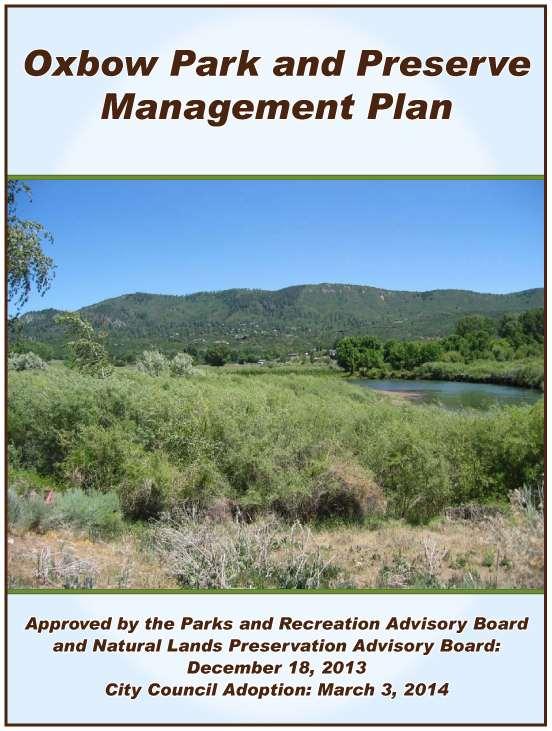
Oxbow Park and Preserve Management Plan
|
|
|
- Brice Morrison
- 6 years ago
- Views:
Transcription
1
2

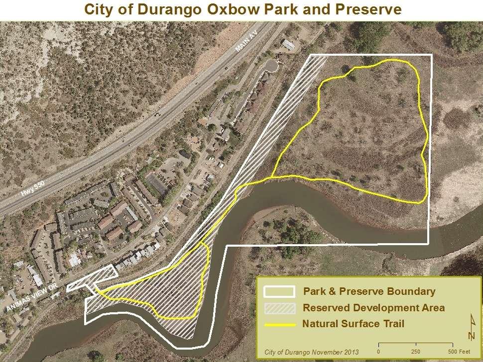
3 Oxbow Park and Preserve Management Plan INTRODUCTION This Plan establishes a framework for the sound stewardship of Oxbow Park and Preserve. Policies, management objectives and envisioned future improvements outlined within this Plan are based on existing baseline information gathered in advance of the property acquisition; public input, and commitments established within the conservation easement donated by the City to the La Plata Open Space Conservancy. Additional baseline data will be collected to allow revision to this Plan as necessary. The Plan provides a succinct overview of this background information and intended stewardship practices. Additionally, the Plan outlines how future potential improvements on the property will be evaluated and considered prior to implementation to ensure consistency with public expectations and conservation commitments. Revisions to this Plan and any associated policies and management objectives will require formal action by pertinent City Advisory Boards and the La Plata Open Space Conservancy (LPOSC). DESCRIPTION OF THE AREA Located east of Animas View Drive along the banks of the Animas River, approximately 1.2 river miles upstream from the 33 rd Street river put-in/take-out, Oxbow Park and Preserve is just over 44 acres. The property includes the acre Cameron-Sterk property acquired with the assistance of Great Outdoors Colorado in 2012 and the 0.39 acre Sherman Parcel, also acquired in Oxbow has 2 distinct areas within the 44 acres one being the Preserve, an area of approximately 38 acres that will remain predominantly undeveloped, in its existing natural state, with primary management objectives focused on conservation, habitat protection, and environmental education. The second area of approximately 6 acres has been reserved for future river access improvements, a section of the Animas River Trail, and for facilities to serve these uses. The map attached to this Plan shows the entire property with the approximate location of the 6 acre Reservation Development Area. Future site improvements envisioned and use of the Reservation Area are addressed later in this Plan. 1
4 BASELINE DOCUMENTATION Baseline data has been collected on the property that includes environmental and mineral assessments, vegetation and photo baseline documentation; and habitat preservation values. This information, summarized below, is included in its entirety in the Baseline Documentation Report available through the City of Durango Parks and Recreation Department and is posted on the City website at The Cameron-Sterk portion of Oxbow Park and Preserve is comprised of approximately 70 percent riparian shrubs, forest, and wetlands; 20 percent non-riparian shrubs, grasses and forbs; and 10 percent river. It lies at an elevation of approximately 6,550 feet. The property has over 4,000 linear feet of river frontage that include sand bar beaches as well as cut slope river banks that are slowly being incised by the meandering Animas River. This meandering also makes deposits on point bars. Riparian vegetation includes Narrow Leaf Cottonwood, Sandbar Willow, Rocky Mountain Juniper and a variety of grasses and forbs. The western part of the property is dominated by desert scrub, primarily Rabbit Brush. Native shrubs useful to wildlife include chokecherry, wild rose and golden currant. A historic oxbow on the property has been slowly filling in and provides pockets of intermittent wetlands. Much of the property experiences consistent spring flooding during high run-off years as only approximately 1 acre of the property lies outside the 100-year floodplain. Approximately 23 acres are located directly within the floodway. Non-native and invasive species, particularly Russian olive, Siberian elm, thistles and other invasive grasses and forbs were prevalent at the time of property acquisition. Efforts to eliminate these invasive species were initiated immediately upon City acquisition. Additional wildlife surveys and documentation will be undertaken on the property starting in 2014 to ensure future management appropriately adheres to the conservation easement and habitat preservation values. CONSERVATION EASEMENT Oxbow Park and Preserve includes the acre Cameron-Sterk property which was acquired with the assistance of Great Outdoors Colorado. This acreage, located east of the Durango & Silverton Narrow Gauge Railroad (D&SNGRR) tracks, has been placed under conservation easement with La Plata Open Space Conservancy. The purpose of the conservation easement is to permanently protect the following values on the property: 1) River floodplain and natural open space for viewshed, habitat and recreation; 2) Natural habitat for wildlife including summer and winter range, winter concentration area, winter forage area, and/or overall range for a variety of species of game and non-game wildlife; and 3) Low-impact recreational opportunities for the community; and educational opportunities for ecological sustainability. 2

5 The conservation easement recognizes and allows certain development to occur within a Development Reservation Area as described more specifically in the recorded conservation easement. The easement is available for review from the City of Durango Parks and Recreation Department and is also posted on the City website. MANAGEMENT OBJECTIVES The City of Durango will manage and develop Oxbow Park and Preserve in a manner that will: Maintain all conservation commitments associated with the recorded conservation easement Improve the natural condition of the property by eliminating invasive and noxious weeds and plant species, and initiate restoration projects to occur that will enhance the ecological values of the property Provide ongoing care, stewardship, law enforcement, and patrol of the property consistent with City parks and open space areas Maintain a natural surface single loop trail corridor near the perimeter of the property. An analysis of all existing trails on the property shall be conducted by the City in conjunction with LPOSC after completion of the wildlife baseline survey to determine the most appropriate final alignment of the permanent trail corridor Provide improvements within the Reserved Development Area to provide river access, associated amenities, and an extension of the Animas River Trail Minimize disturbance and impacts to environmentally sensitive areas Ensure all new development strictly adheres to pertinent local, state, and federal development and environment regulations and requirements 3
6 INTERIM MANAGEMENT POLICIES Interim management policies have been established for Oxbow Park and Preserve in recognition that certain management activities cannot occur until the property is annexed and permanent site improvements have been completed. These policies shall remain in effect only as long as necessary in order to ensure protection of the property s resource values, and to minimize impacts to the adjacent property owners during this interim period. The following policies shall be in effect during this interim period: 1. The 38-acre preserve area within Oxbow Park and Preserve will initially be closed to the public December 1, 2013 through June 30, In the interim, the City will endeavor to collect wildlife information including existing literature pertaining to best management practices for habitat preservation. Site specific wildlife data will also be collected by volunteers to establish baseline information. The City will determine future adjustments to the closure dates and boundary based upon the information obtained and input from the Parks and Recreation Advisory Board and the Natural Lands Preservation Advisory Board. 2. Commercial use of Oxbow is not permitted until site specific access improvements have been completed to accommodate such use. Site development planning is scheduled to occur in There shall be no motor vehicle parking available at Oxbow Park until site improvements have been completed to accommodate such use. Scheduling of site improvements will occur only after completion of site development planning. 4. The La Plata County Sheriff shall provide law enforcement until the property is annexed into the City. Following annexation, the Durango Police Department will provide law enforcement. Annexation of the property is scheduled to occur prior to the 2014 river use season. 5. Oxbow Park and Preserve is located within the Animas Mosquito Control District and the willows on the property have historically been mowed to provide access to standing water for treatment of the mosquito larvae. Mowing on the property will be limited to the existing natural surface trail corridor and mosquito abatement will be performed by Animas Mosquito Control District in accordance with best management practices. Any proposed changes in protocol will require written City approval and review and approval by LPOSC in advance of proposed activities occurring. LONG-TERM MANAGEMENT POLICIES 1. Management activities shall be consistent with this adopted Plan and recorded conservation easement. Proposed activities deemed inconsistent with the Management Plan shall be circulated to the appropriate City Departments and Advisory Boards for review and comment prior to any action being taken. Proposed activities on acreage under conservation easement shall also be reviewed by La Plata Open Space Conservancy (LPOSC). 4
7 2. Proposed changes to the Management Plan shall be circulated to the appropriate City Departments and Advisory Boards for review and comment prior to any action being taken. Changes proposed for acreage under conservation easement shall also be reviewed by La Plata Open Space Conservancy. 3. Areas located outside the Development Reservation Area shall be maintained in a natural state with public recreational use limited to trail-oriented and passive activities such as viewing wildlife consistent with the requirements of this Plan and the recorded conservation easement. 4. All commercial use will require a separate river access permit issued by the Parks and Recreation Department with appropriate limitations on use dependent upon the carrying capacity of the property as determined by the City. Permitted Commercial River Outfitters for Oxbow Park are required to work with the City to ensure all users of the Nature Paddling Trail adhere to the guidelines of use on this section of river in Durango. 5. All public uses and activities on the property shall be subject to all City rules and regulations. To ensure a pleasurable experience and to protect Oxbow Park and Preserve, be courteous of other park users and neighbors. The following uses/activities shall be specifically prohibited on the property: - Overnight Camping - Camp fires - Hunting or discharge of firearms/weapons - Organized and special events except by permit - Dogs off leash - Injury to or molestation of birds, game or wildlife - Smoking, use of alcohol or drugs - Unauthorized construction of trails, berms, jumps, or other recreational structures - Destruction or removal of soils, rocks, natural vegetation or other materials except for purposes of property maintenance and improvements consistent with this Plan - Other resource disturbing activities such as construction of forts, tree houses, seating areas, lean-tos and other man-made structures - Excessive noise 6. Park hours, including the river access, are consistent with other City parks. Park and river access hours may be revised administratively as necessary. Park Permits are required for after-hours activities and organized groups. 7. The section of river between Oxbow Park and Preserve downstream to the 33 rd Street River Access is designated as a Nature Paddling Trail. River users taking access from Oxbow Park shall: (a) respect nature and leave no trace; (b) engage in quiet use of the river; (c) respect private property including no trespassing both upstream and downstream of the Park; (d) all river craft should be propelled in this section with a paddle, swim flippers or swim hand paddles; and (e) all river users should wear an approved Personal Flotation Device (PFD). 5
8 8. There shall be adequate and effective law enforcement at Oxbow Park and Preserve by City Park staff and Durango Police. City staff will routinely patrol the property particularly during high use times to ensure a quality river experience. At its discretion, Park staff may elect from time to time to temporarily close the entire property, or selected areas of the property, when it is deemed necessary for the protection of the property s natural resource values, the general public, and/or for rejuvenation of specific resources including wildlife habitat and vegetation. This may also include during river run off events that result in property flooding. 9. Property assessments may be taken from time to time to determine the specific location, type, and quantities of unique plant and animal habitat/species, and unique natural or archeological features in advance of any stewardship activities consistent with this Management Plan. 10. La Plata Open Space Conservancy shall provide annual monitoring reports referring to the natural assets and conservation values listed in the conservation easement to assist the City with stewardship efforts. 11. Environmental education and research projects may be conducted on the property with advance approval by the City. 12. The City will develop a proactive monitoring plan with associated metrics. FUTURE PROPOSED IMPROVEMENTS Future site improvements will be limited to public access amenities, signage, and extension of the Animas River Trail. All improvements must be consistent with the recorded conservation easement and commitments made to Great Outdoors Colorado, and will be considered and approved by the Parks and Recreation Advisory Board, the Natural Lands Preservation Advisory Board, pertinent City Departments, and the La Plata Open Space Conservancy prior to construction activities occurring. The future site improvements at Oxbow Park and Preserve, previously referred to as the Cameron-Sterk property, were discussed by the community during the development of the adopted 2012 Durango Animas River Corridor Management Plan. The design of park and river access improvements at Oxbow Park is scheduled to be initiated by the City in The exact location of amenities, signage, access drives and parking will be determined during the development of the site plan which will be a public process. Annexation of the acreage located east of the tracks will occur in advance of any site development occurring. Envisioned improvements include: 1) An extension of the hard-surface Animas River Trail along the westerly edge of the property, with an eventual extension further north of the property; 2) a river put-in/take-out for non-motorized crafts in the southwestern corner of the property in the vicinity of the beach; 6

9 3) shade structure(s) and restroom; 4) parking area and associated amenities; 5) natural-surface trail; 6) Interpretive/educational, informational and way-finding signage; and 7) Park benches along the trails. RESERVED DEVELOPMENT AREA Other than the natural-surface trail that meanders around the Preserve area, benches and interpretive signage, only the Development Reservation Area may be further developed. The attached map shows an approximation of where allowable improvements may be located in the future. Final design and engineering will be required to determine specific locations within this building envelope. The recorded conservation easement specifies the Reserved Development Area as up to 6 acres. Future improvements on the property will be restricted to this building envelope on the southwest section of the property and also includes an area generally paralleling the Durango and Silverton Narrow Gauge Railroad tracks on the northwestern boundary of the property to accommodate the future extension of the Animas River Trail. Since the building envelope and trail corridor remain part of the conservation easement, proposed improvements will be reviewed and approved by LPOSC. The addition of the 0.39 acre Sherman parcel west of the tracks provides opportunity to locate some site improvements closer to Animas View Drive, and away from the floodplain and existing vegetation near the river. \ 7
10 STEWARDSHIP ACTIVITIES Routine Maintenance: Routine maintenance will be based on regular inspection and need by the Parks and Recreation Department. Typical ongoing maintenance shall include weed and noxious species mitigation, trash removal, vandalism repair, trail repair and improvements, and other facility repair or maintenance as needed. Flora and Fauna Protection and Enhancements: Based on the finding of existing or future property assessments, monitoring reports, routine inspection by the City, and other research efforts undertaken, protection and enhancement efforts consistent with this Management Plan may be undertaken to improve the ecological and biological diversity and health of the property. Planning for River Channel Movement: The natural meanders of the river are expected to move over time. The property boundaries, site improvements and natural features may be gradually or episodically affected. This process will be considered in design and management to provide the maximum protection and sustainability of the conservation values of this property and neighboring properties. AMENDMENT/UPDATE This Management Plan may be amended from time to time as necessary. Any proposed Plan amendment or update will be undertaken in consultation with the Natural Lands Preservation Advisory Board, the Parks and Recreation Advisory Board, pertinent City Departments, and the La Plata Open Space Conservancy. * * * * * 8
11 9
Oxbow Park and Preserve Management Plan Draft: December 2013
 Draft: December 2013 INTRODUCTION This Plan establishes a framework for the sound stewardship of Oxbow Park and Preserve. Policies, management objectives and envisioned future improvements outlined within
Horse Gulch Management Plan Final Draft: April 18, 2013
 I. INTRODUCTION This Plan provides a framework for the sound stewardship of the City of Durango Horse Gulch open space area. The Plan includes baseline information regarding the area, management objectives
RECITALS. B. WHEREAS, Ranch, its successors and assigns, are referred to in the Easement as the Grantor ; and
 Basic Components of Management Plans Associated with Conservation Easement Acquisitions Where A Land Trust Or other third party Is the Grantee April 17, 2012 Key: Text in normal font, without highlight,
THE COUCHICHING CONSERVANCY LAND STEWARDSHIP POLICY. As approved by the Board, April 30, 2007
 THE COUCHICHING CONSERVANCY LAND STEWARDSHIP POLICY As approved by the Board, April 30, 2007 When one tugs at a single thing in nature, he finds it attached to the rest of the world. John Muir This policy
Application Procedures for Easements or Rights of Way on City of Fort Collins Natural Areas and Conserved Lands March 2012
 Application Procedures for Easements or Rights of Way on City of Fort Collins Natural Areas and Conserved Lands March 2012 IMPORTANT NOTE: This document was created to accompany the City of Fort Collins
GWINNETT COUNTY CSO CONSERVATION SUBDIVISION OVERLAY DISTRICT REQUIREMENTS
 GWINNETT COUNTY CSO CONSERVATION SUBDIVISION OVERLAY DISTRICT REQUIREMENTS Section 1316. CSO Conservation Subdivision Overlay District. 1. Purposes. The purposes of this overlay district are as follows:
Conservation Easement Stewardship
 Conservation Easements are effective tools to preserve significant natural, historical or cultural resources. Conservation Easement Stewardship Level of Service Standards March 2013 The mission of the
LLC & MLLC Property Bismark Meadows Bonner County, Idaho
 Vital Ground Property Management Plan LLC & MLLC Property Bismark Meadows Bonner County, Idaho December 10, 2009 (updated 2/12/13) Ryan Lutey The Vital Ground Foundation Building T-2, Fort Missoula Road
Chestnut Street and Eliot Street
 BASELINE DOCUMENTATION REPORT and LAND MANAGEMENT PLAN Massachusetts Executive Office of Energy and Environmental Affairs Local Acquisitions for Natural Diversity (LAND) Grant Program Property name: Warren
TOWN OF ORO VALLEY PLANNING & ZONING COMMISSION MEETING DATE: December 6, 2011
 PLANNING & ZONING COMMISSION MEETING DATE: December 6, 2011 TO: FROM: SUBJECT: PLANNING & ZONING COMMISSION Matt Michels, Senior Planner mmichels@orovalleyaz.gov; tel. 229-4822 Public Hearing: Rancho de
City of LaBelle Passive Recreational Park Management Plan
 City of LaBelle Passive Recreational Park Management Plan Table of Contents Park Management Plan 1-7 LIST OF APPENDICES Appendix 1 Appendix 2 Appendix 3 Appendix 4 Appendix 5 Initial Lease First amendment
METROPOLITAN COUNCIL 390 North Robert Street, St. Paul, MN Phone (651) TDD (651)
 TDD (651)") METROPOLITAN COUNCIL 390 North Robert Street, St. Paul, MN 55101 Phone (651) 602-1000 TDD (651) 291-0904 DATE: December 26, 2012 TO: Metropolitan Parks and Open Space Commission FROM: Jan Youngquist, AICP;
METROPOLITAN COUNCIL 390 North Robert Street, St. Paul, MN 55101 Phone (651) 602-1000 TDD (651) 291-0904 DATE: December 26, 2012 TO: Metropolitan Parks and Open Space Commission FROM: Jan Youngquist, AICP;
Sample Baseline Documentation Report (BDR) Annotated Template for Environmentally Important Land
 Annotated Template for Environmentally Important Land") Sample Baseline Documentation Report (BDR) Annotated Template for Environmentally Important Land The baseline documentation report (BDR) provides a snap shot of the biophysical condition of a property
Sample Baseline Documentation Report (BDR) Annotated Template for Environmentally Important Land The baseline documentation report (BDR) provides a snap shot of the biophysical condition of a property
MANAGEMENT PLAN FOR THE TOWN-OWNED LAND ("PROTECTED PROPERTY ), Norwich, Vermont (Updated April 2008) I. INTRODUCTION
, Norwich, Vermont (Updated April 2008) I. INTRODUCTION") MANAGEMENT PLAN FOR THE TOWN-OWNED LAND ("PROTECTED PROPERTY ), Norwich, Vermont (Updated April 2008) I. INTRODUCTION This document is the Management Plan for the "Protected Property" defined herein, as
MANAGEMENT PLAN FOR THE TOWN-OWNED LAND ("PROTECTED PROPERTY ), Norwich, Vermont (Updated April 2008) I. INTRODUCTION This document is the Management Plan for the "Protected Property" defined herein, as
Community Development Committee
 Community Development Committee For the Metropolitan Council meeting of February 13, 2013 Committee Report Business Item 2013-29 ADVISORY INFORMATION Date Prepared: January 25, 2013 Subject: Rice Creek
Introduction. Management Strategies for Central Maritime Chaparral. Reasons for Protection
 Management Strategies for Central Maritime Chaparral by Tami Nakahara Introduction The central maritime chaparral community (CMC) in the Elkhorn Slough Watershed, North Monterey County, California is classified
CITY OF FORT COLLINS NATURAL AREAS AND CONSERVED LANDS EASEMENT POLICY
 CITY OF FORT COLLINS NATURAL AREAS AND CONSERVED LANDS EASEMENT POLICY Adopted January 3, 2012 PURPOSE: The purpose of the policy statement is to clarify the policies and procedures of the City of Fort
DRAFT FOR PUBLIC HEARING (rev. March, 2016)
") Chapter 200. ZONING Article VI. Conservation/Cluster Subdivisions 200-45. Intent and Purpose These provisions are intended to: A. Guide the future growth and development of the community consistent with
Chapter 200. ZONING Article VI. Conservation/Cluster Subdivisions 200-45. Intent and Purpose These provisions are intended to: A. Guide the future growth and development of the community consistent with
Conservation Collier Red Maple Swamp Preserve
 Preserve Extended Interim Management Plan First Extension Prepared By: Collier County s Conservation Collier Program Parks & Recreation Department 15000 Livingston Road Naples, FL 34109 May 2013 G:\CDES
Land Uses, Maps, Illustrations and Locations
 2016 KINGS MILL COMMUNITY INFORMATION THE MONTGOMERY KINGS MILL HOMEOWNER S ASSOCIATION INC. ( HOA ) HAS PREPARED HIS COURTESY NOTICE OF SUMMARY INFORMATION TO ENCOURAGE THOSE INTERESTED IN KINGS MILL
MARK TWAIN LAKE MASTER PLAN CLARENCE CANNON DAM AND MARK TWAIN LAKE MONROE CITY, MISSOURI
 MARK TWAIN LAKE MASTER PLAN CLARENCE CANNON DAM AND MARK TWAIN LAKE MONROE CITY, MISSOURI CHAPTER 4 LAND ALLOCATION, LAND CLASSIFICATION, WATER SURFACE, AND EASEMENT LANDS This Master Plan is a land use
Napa County Planning Commission Board Agenda Letter
 Agenda Date: 9/20/2017 Agenda Placement: 8C Napa County Planning Commission Board Agenda Letter TO: FROM: Napa County Planning Commission Charlene Gallina for David Morrison - Director Planning, Building
WESTERLY MUNICIPAL LAND TRUST RULES AND REGULATIONS
 Trustees; Les Crandall, Chairman James Federico III Giorgio Gencarelli Gail Mallard, Secretary Nancy Martin Lise Mayers Richard Silva WESTERLY MUNICIPAL LAND TRUST WESTERLY MUNICIPAL LAND TRUST RULES AND
Guide to Combined Preliminary and Final Plats
 Guide to Combined Preliminary and Final Plats Introduction The Douglas County is committed to providing open, transparent application processes to the public. This Guide is provided to assist anyone interested
CONSERVATION EASEMENT GRANT AND AGREEMENT. ( the "Grantor") - and - Strathcona County ( the "Grantee")
 - and - Strathcona County ( the Grantee)") CONSERVATION EASEMENT GRANT AND AGREEMENT BETWEEN: ( the "Grantor" - and - Strathcona County ( the "Grantee" (the Grantor and the County sometimes referred to jointly as the "Parties" IN CONSIDERATION
CONSERVATION EASEMENT GRANT AND AGREEMENT BETWEEN: ( the "Grantor" - and - Strathcona County ( the "Grantee" (the Grantor and the County sometimes referred to jointly as the "Parties" IN CONSIDERATION
WRP COMPATIBLE USE PERMITS
 WRP COMPATIBLE USE PERMITS By statute, WRP easements are acquired to protect, restore, and enhance the functions of wetland ecosystems for migratory birds and wetland dependent wildlife Reservations in
Chapter 100 Planned Unit Development in Corvallis Urban Fringe
 100.100 Scope and Purpose. Chapter 100 Planned Unit Development in Corvallis Urban Fringe (1) All applications for land divisions in the Urban Residential (UR) and Flood Plain Agriculture (FPA) zones within
( ) Ordinance. Environmental Resources Management
 Ordinance. Environmental Resources Management") PALM BEACH COUNTY BOARD OF COUNTY COMMISSIONERS AGENDA ITEM SUMMARY Agenda Item #:5 I/" 3 Meeting Date: April 1,2008 ( ) Consent Department Submitted By: Submitted For: ( ) Ordinance Environmental Resources
PALM BEACH COUNTY BOARD OF COUNTY COMMISSIONERS AGENDA ITEM SUMMARY Agenda Item #:5 I/" 3 Meeting Date: April 1,2008 ( ) Consent Department Submitted By: Submitted For: ( ) Ordinance Environmental Resources
WASCO COUNTY PRELIMINARY SUBDIVISION APPLICATION
 WASCO COUNTY PRELIMINARY SUBDIVISION APPLICATION DETAILED SPECIFIC WRITTEN REQUEST File Number: SDV- Number of Proposed Lots & their Dimensions: PRELIMINARY SUBDIVISION PLAN REQUIREMENTS The approval of
Town of Falmouth s Four Step Design Process for Subdivisions in the Resource Conservation Zoning Overlay District
 Town of Falmouth s Four Step Design Process for Subdivisions in the Resource Conservation Zoning Overlay District All subdivisions shall be designed in accordance with the following four-step process.
Antelope Ridge Wind Farm Habitat Mitigation Plan November 2011
 Antelope Ridge Wind Farm Habitat Mitigation Plan November 2011 I. Introduction The Antelope Ridge Wind Farm will be constructed in two phases, in the locations as shown on the attached map, Exhibit A.
CONDITIONAL USE PERMIT Application Packet
 CONDITIONAL USE PERMIT Application Packet Community Development Department 1020 East Pioneer Road, Draper, UT 84020 (801) 576-6539 Fax (801) 576-6526 Dear Applicant, This application packet has been developed
Diamond Falls Subdivision PROPOSED YELLOWSTONE COUNTY BOARD OF PLANNING FINDINGS OF FACT
 Diamond Falls Subdivision PROPOSED YELLOWSTONE COUNTY BOARD OF PLANNING FINDINGS OF FACT The City/County Planning Staff has prepared the Findings of Fact for the Diamond Falls Subdivision. These findings
PENINSULA TOWNSHIP DONATION of DEVELOPMENT RIGHTS ORDINANCE (DDR, No. 45)
") PENINSULA TOWNSHIP DONATION of DEVELOPMENT RIGHTS ORDINANCE (DDR, No. 45) THE TOWNSHIP OF PENINSULA, GRAND TRAVERSE COUNTY, MICHIGAN ORDAINS: Section 101 General Provisions A. Title: This Ordinance shall
PENINSULA TOWNSHIP DONATION of DEVELOPMENT RIGHTS ORDINANCE (DDR, No. 45) THE TOWNSHIP OF PENINSULA, GRAND TRAVERSE COUNTY, MICHIGAN ORDAINS: Section 101 General Provisions A. Title: This Ordinance shall
Chapter CITY PARKS
 Chapter 11.03 CITY PARKS Sections: 11.03.010 Purpose 11.03.020 Definitions 11.03.030 Allowable hours of operation 11.03.040 Prohibited activities 11.03.050 Use of parks and permits for exclusive or special
ARTICLE XI - CONSERVATION SUBDIVISIONS
 ARTICLE XI - CONSERVATION SUBDIVISIONS Section 1101: Purpose and Intent. This Article is intended to provide for residential subdivisions that are designed based first and foremost on the preservation
Conservation Partners Legacy Grant Application
 CPL Applications (Total to date: 129) Spreadsheet Conservation Partners Legacy Grant Application CPL1000084 Name and Contact Project Identifier: CPL1000084 Project Name: CREP Easement Invasive Species
Rarity Pointe Commercial Recreation and Residential Development on Tellico Reservoir, Loudon and Monroe Counties, TN
 ======================================================================= Federal Register: September 10, 2003 (Volume 68, Number 175) =======================================================================
COASTAL CONSERVANCY. Staff Recommendation August 2, 2012 HARE CREEK BEACH COASTAL ACCESS TRAIL. Project No Project Manager: Lisa Ames
 COASTAL CONSERVANCY Staff Recommendation August 2, 2012 HARE CREEK BEACH COASTAL ACCESS TRAIL Project No. 08-001-02 Project Manager: Lisa Ames RECOMMENDED ACTION: Authorization to disburse up to $60,000
OPEN SPACE & RECREATION PLAN
 OPEN SPACE & RECREATION PLAN HOPEWELL TOWNSHIP Cumberland County, New Jersey Prepared by: Hopewell Township Environmental Commission Final October 2011 (THIS PAGE INTENTIONALLY LEFT BLANK) PUBLIC MEETINGS
Neds Corner Station. What is a Conservation Covenant?
 Neds Corner Station What is a Conservation Covenant? www.trustfornature.org.au What is a conservation covenant? A conservation covenant (deed of covenant) is a voluntary, legal agreement made between a
Larimer County Planning Dept. Procedural Guide for 1041 PERMITS
 - Larimer County Planning Dept. Procedural Guide for 1041 PERMITS PLEASE NOTE: A PRE-APPLICATION CONFERENCE IS REQUIRED PRIOR TO SUBMITTING THIS APPLICATION. PURPOSE: State Statutes allow local governments
Submittal of the Minutes from the March 9, 2011, April 5, 2011, and April 19, 2011 Cabinet Meetings.
 AGENDA BOARD OF TRUSTEES OF THE INTERNAL IMPROVEMENT TRUST FUND JUNE 16, 2011 Attachments to the items below can be viewed at the following link: http://www.dep.state.fl.us/secretary/cab/public_notices.htm
APPLICATION FOR PERMIT: (Pursuant to Ord & Reso ) 4d Habitat Loss Permit Vegetation Removal Tree Removal. Address:
 4d Habitat Loss Permit Vegetation Removal Tree Removal. Address:") CITY OF ESCONDIDO Planning Division 201 North Broadway Escondido, CA 92025-2798 (760) 839-4671 Fax: (760) 839-4313 APPLICATION FOR PERMIT: (Pursuant to Ord. 91-54 & Reso. 94-436) Case No: FOR INTERNAL
CITY OF ESCONDIDO Planning Division 201 North Broadway Escondido, CA 92025-2798 (760) 839-4671 Fax: (760) 839-4313 APPLICATION FOR PERMIT: (Pursuant to Ord. 91-54 & Reso. 94-436) Case No: FOR INTERNAL
Pit-McCloud River Watershed
 Pit-McCloud River Watershed Agricultural Uses...Much existing data regarding McArthur Swamp stocking rates and timing is available through Larry Fererro, Shasta County UC Davis Cooperative Extension Office.
PROJECT SCORING GUIDANCE. Introduction: National Proiect Selection:
 FOREST LEGACY PROGRAM PROJECT SCORING GUIDANCE Introduction: This document provides guidance to the National Review Panel on how to score individual Forest Legacy Program (FLP) projects, including additional
OPEN-SPACE CONVERSION REQUEST
 OPEN-SPACE CONVERSION REQUEST Applicant: Board Meeting: February 9, 2017 Landowner: Normandy Capital, LLC VOF Easement: BAT-03678 Table of Contents: Cover Page 1 Table of Contents 2 Application Overview
Chapter 10 Local Protection Measures
 The DPC fully supports the protection of private property rights and the DPC will work to ensure that there will be no negative impacts stemming from NHA activities on private property, should the designation
Conceptual Scheme SE W4
 December 2012 1. PURPOSE 1.1. The purpose of a Conceptual Scheme (CS) is as follows: a) To provide a framework for the subsequent subdivision and/or development of land within the Country Residential Policy
Introduction to INRMP Implementation Options
 El Dorado County Integrated Natural Resources Management Plan Introduction to INRMP Implementation Options 1 Our approach to the options evaluation is based on the INRMP components as they are currently
Forest Service Role CHAPTER 2
 CHAPTER 2 Forest Service Role Implementation of the Management Plan charters a federal presence with an expanded focus beyond traditional Forest Service roles. In addition to administration of the National
Steamboat Fireworks for Free Special Use Permit
 Steamboat Fireworks for Free Special Use Permit ACTIVITY #: PL-18-167 HEARING DATES: Planning Commission: 09/20/18 at 6:00pm Board of County Commissioners: 10/02/18 at 1:30pm PETITIONER: PETITION: LEGAL:
Using Easements to Conserve Biodiversity. Jeff Lerner Defenders of Wildlife
 Using Easements to Conserve Biodiversity Jeff Lerner Defenders of Wildlife jlerner@defenders.org Northeast LTA June 10, 2006 Defenders of Wildlife Mission: to protect native wild animals and plants in
RENITA HURDSMAN BEAR RIVER STATE PARK LAND EXCHANGE PROPOSAL
 DETAILED ANALYSIS RENITA HURDSMAN BEAR RIVER STATE PARK LAND EXCHANGE PROPOSAL June 1, 2006 Prepared by the Office of State Lands and Investments Herschler Building, 3W 122 West 25 th Street Cheyenne,
Texas Parks and Wildlife Foundation Buffer Lands Program Program Description and Application
 Texas Parks and Wildlife Foundation Texas Parks and Wildlife Foundation s mission is to provide private support to Texas Parks and Wildlife Department to manage and conserve the natural and cultural resources
CATALOGING, MONITORING AND MANAGING INVASIVE SPECIES ON POST LANDS. PSU Geog596A Capstone Proposal Dale Jantzen Dec 17, 2015
 CATALOGING, MONITORING AND MANAGING INVASIVE SPECIES ON POST LANDS PSU Geog596A Capstone Proposal Dale Jantzen Dec 17, 2015 PROJECT OUTLINE AND PURPOSE Define a particular need within a non-profit land
Georgia Conservation Tax Credit Program Frequently Asked Questions
 Georgia Conservation Tax Credit Program Frequently Asked Questions What are the minimum requirements for eligibility under the Georgia Conservation Tax Credit Program (GCTCP)? Individual and corporate
ARTICLE FIVE FINAL DRAFT
 ARTICLE FIVE 021218 FINAL DRAFT Sec. 503.6 Open Space Preservation Option Open Space Preservation Option Open Space Preservation developments may be approved in the AR, R-1, R-2 and R-3 zoning districts,
Draft Zoning Changes for the 2nd Planning Board Public Hearing, January 22, 2018.
 Draft Zoning Changes for the 2nd Planning Board Public Hearing, January 22, 2018. No changes were made at the 1st Public Hearing. Proposed wording for the 1 st Public Hearing in red, eliminated text in
Corte Madera Marsh Restoration Project Update
 Corte Madera Marsh Restoration Project Update Building and Operating Committee Agenda Item No. 5 August 25, 2016 Photo credit: WRA Background of Site 1. 72 acre parcel carved out of larger property acquired
A. Preserve natural resources as identified in the Comprehensive Plan.
 1370.08 Conservation Residential Overlay District. Subd. 1 Findings. The City finds that the lands and resources within the Conservation Residential Overlay District are a unique and valuable resource
Creek Rehabilitation Plan for Apple Valley Questions and Answers from the Pre-Bid Meeting and Site Visit 06/23/2016
 Questions and Answers from the Pre-Bid Meeting and Site Visit 06/23/2016 Q: What are the threatened and endangered species concerns in the area? A: This is potential habitat for Prebles Meadow Jumping
Wildlife Habitat Conservation and Management Program
 EXHIBIT 1 PC-2015-4106 ODFW Guide Wildlife Habitat Conservation and Management Program Manual for Counties and Cities Oregon Department of Fish and Wildlife March 2006 Table of Contents 1. Introduction
WEST VIRGINIA DIVISION OF FORESTRY Cooperative Forest Legacy Program. Sample Conservation Easement
 WEST VIRGINIA DIVISION OF FORESTRY Cooperative Forest Legacy Program Sample Conservation Easement This document is included in the forest legacy kit as an example for information and possible guidance
APRIL 30, ILL. ADM. CODE 2580 CH. I, SEC. 2580
 TITLE 17: CONSERVATION CHAPTER I: DEPARTMENT OF NATURAL RESOURCES SUBCHAPTER f: ADMINISTRATIVE SERVICES PART 2580 CONSERVATION STEWARDSHIP PROGRAM Section 2580.10 Definitions 2580.20 Eligibility 2580.30
Agricultural Lease Bid Process and Policy Updated September 21, 2017
 Agricultural Lease Bid Process and Policy Updated September 21, 2017 Introduction: Pitkin County Open Space & Trails (OST) was established by the voters of Pitkin County in 1990 with the following mission;
ATTACHMENT A: FINDINGS
 ATTACHMENT A: FINDINGS 1.0 CEQA FINDINGS 1.1 ENVIRONMENTAL IMPACT REPORTS Findings pursuant to public resources code Section 21081 and the California Environmental Quality Act Guidelines Sections 15090
MODEL DEED RESTRICTION FOR THE PENNSYLVANIA STATE PROGRAMMATIC GENERAL PERMIT-3 (PASPGP-3) DECLARATION OF RESTRICTIVE COVENANTS FOR CONSERVATION
 DECLARATION OF RESTRICTIVE COVENANTS FOR CONSERVATION") MODEL DEED RESTRICTION FOR THE PENNSYLVANIA STATE PROGRAMMATIC GENERAL PERMIT-3 (PASPGP-3) DECLARATION OF RESTRICTIVE COVENANTS FOR CONSERVATION THIS DECLARATION OF RESTRICTIVE COVENANTS FOR CONSERVATION
MODEL DEED RESTRICTION FOR THE PENNSYLVANIA STATE PROGRAMMATIC GENERAL PERMIT-3 (PASPGP-3) DECLARATION OF RESTRICTIVE COVENANTS FOR CONSERVATION THIS DECLARATION OF RESTRICTIVE COVENANTS FOR CONSERVATION
Proposed Management Plan for SCE&G Future Development Property December 2007
 Proposed Management Plan for SCE&G Future Development Property December 2007 BASELINE 1984 License Classifications Future Development Forest and Game Management Easement Project Works Recreation (Current
New Cingular Wireless Telecommunication Tower at County Road 48, Milner Conditional Use Permit
 New Cingular Wireless Telecommunication Tower at 39415 County Road 48, Milner ACTIVITY #: Conditional Use Permit PP2012-023 HEARING DATES: Planning Commission (PC): August 16, 2012 at 6:00pm PETITIONER:
3.23 LANDS AND SPECIAL USES
 3.23 LANDS AND SPECIAL USES Introduction This section addresses those aspects of SJPLC management relating to public land ownership and use. Special Use Permits, rights-of-way (ROW) grants, easements,
Letter of Intent May 2017 (Revised November 2017)
") THE BEACH AT WOODMOOR LETTER OF INTENT MAY 2017 (REVISED NOVEMBER 2017) OWNER/APPLICANT: CONSULTANT: Lake Woodmoor Holdings LLC N.E.S. Inc. 1755 Telstar Drive, Suite 211 619 North Cascade Avenue Colorado
THE BEACH AT WOODMOOR LETTER OF INTENT MAY 2017 (REVISED NOVEMBER 2017) OWNER/APPLICANT: CONSULTANT: Lake Woodmoor Holdings LLC N.E.S. Inc. 1755 Telstar Drive, Suite 211 619 North Cascade Avenue Colorado
CHAPTER 3 PRELIMINARY PLAT
 10-3-1 10-3-3 SECTION: CHAPTER 3 PRELIMINARY PLAT 10-3-1: Consultation 10-3-2: Filing 10-3-3: Requirements 10-3-4: Approval 10-3-5: Time Limitation 10-3-6: Grading Limitation 10-3-1: CONSULTATION: Each
Strategic Growth Council: Identifying Infill Barriers
 Streamlining Infill in the CEQA Guidelines (SB 226) Strategic Growth Council: Identifying Infill Barriers Looking within state agencies to reduce conflicts and promote successful programs Working with
OPEN SPACE PRESERVATION. Reflections on the Value of Acquiring Property for Preservation Purposes
 OPEN SPACE PRESERVATION Reflections on the Value of Acquiring Property for Preservation Purposes What is open space and what does it do? The Town Plan of Conservation and Development defines it as follows:
Biodiversity Planning Policy and Guidelines for (LEP) Rezoning Proposals
 Rezoning Proposals") Council Policy Biodiversity Planning Policy and Guidelines for (LEP) Rezoning Proposals Table of Contents Table of Contents... 1 Policy... 2 Policy Objectives... 2 Policy Statement... 2 Guidelines... 2
Council Policy Biodiversity Planning Policy and Guidelines for (LEP) Rezoning Proposals Table of Contents Table of Contents... 1 Policy... 2 Policy Objectives... 2 Policy Statement... 2 Guidelines... 2
Conservation Area Management Statement Brookwood Wildlife Area
 Conservation Area Management Statement Brookwood Wildlife Area Resolution #: Approval: Issue Date: Date of Last Revision: Page: 4 Table of Contents 1. Purpose. 1 2. Property Description 1 2.1. Legal description.
Conservation Design Subdivisions
 Conservation Design Subdivisions An excerpt from the Rules and Regulations Governing Division of Land in Sheridan County, Wyoming, November 5, 2010 Sheridan County Public Works Department 224 S. Main Street
JOINT PUBLIC NOTICE CORPS OF ENGINEERS STATE OF ARKANSAS Application Number: Date: December 9, 2016 Comments Due: January 3, 2017
 US Army Corps of Engineers Little Rock District JOINT PUBLIC NOTICE CORPS OF ENGINEERS STATE OF ARKANSAS Application Number: 2016-00183-1 Date: December 9, 2016 Comments Due: January 3, 2017 TO WHOM IT
IRS FORM 8283 SUPPLEMENTAL STATEMENT DONATION OF CONSERVATION EASEMENT
 Name(s) shown on income tax return Identifying Number Robert T. Landowner 021-34-1234 Susan B. Landowner 083-23-5555 IRS FORM 8283 SUPPLEMENTAL STATEMENT DONATION OF CONSERVATION EASEMENT On November 12,
ARTICLE 5 GENERAL REQUIREMENTS
 5.1 SUITABILITY OF THE LAND ARTICLE 5 GENERAL REQUIREMENTS 5.1.1 Land subject to flooding, improper drainage or erosion, and land deemed to be unsuitable for development due to steep slope, unsuitable
Article 3 - Rural Districts
 rticle 3 - Rural Districts Div. 3.1. -40: griculture 40 (OI Only) 3-2 3.1.1. Intent... 3-2 3.1.2. Lot Dimensions... 3-2 3.1.3. uilding Placement... 3-3 3.1.4. uilding Height... 3-3 Div. 3.2. -20: griculture
Land Conservation Agreements Project Guidance
 Land Conservation Agreements Project Guidance Stakeholder Informed OTHER OPTIONS Introduction Enhanced or permanent protection of corporate lands through land conservation agreements means that companies
The Guadalupe Blanco River Trust and the Guadalupe-Blanco River Authority: Creating and Then Working with a Non-Profit Conservation Partner
 The Guadalupe Blanco River Trust and the Guadalupe-Blanco River Authority: Creating and Then Working with a Non-Profit Conservation Partner Todd Votteler, Guadalupe-Blanco River Authority South Central
IMPLEMENTING AGREEMENT. for the EAST CONTRA COSTA COUNTY HABITAT CONSERVATION PLAN/ NATURAL COMMUNITY CONSERVATION PLAN.
 IMPLEMENTING AGREEMENT for the EAST CONTRA COSTA COUNTY HABITAT CONSERVATION PLAN/ NATURAL COMMUNITY CONSERVATION PLAN by and between EAST CONTRA COSTA COUNTY HABITAT CONSERVANCY, COUNTY OF CONTRA COSTA,
MANDATORY HOA DISCLOSURE SUMMARY FOR LONE STAR RANCH SINGLE FAMILY HOMES
 MANDATORY HOA DISCLOSURE SUMMARY FOR LONE STAR RANCH SINGLE FAMILY HOMES The following notice is required by Florida Statue 720.401: 1. AS A PURCHASER OF PROPERTY IN THIS COMMUNITY, YOU WILL BE OBLIGATED
The Ranches Sketch Plan
 The Ranches Sketch Plan APPLICATION: RURAL LAND USE PROCESS (AKA CLUSTER DEVELOPMENT) HEARING DATES: Planning Commission: 12 July 2017 at 6:30 pm Board of County Commissioners: TBD APPLICANT: REQUEST:
THIS DECLARATION OF RESTRICTIVE COVENANTS is made this day of, 20, by ("Covenantor"). RECITALS
. RECITALS") Model for Use with Permits Without Mitigation Plans STATE OF COUNTY OF DECLARATION OF RESTRICTIVE COVENANTS THIS DECLARATION OF RESTRICTIVE COVENANTS is made this day of, 20, by ("Covenantor"). RECITALS
Model for Use with Permits Without Mitigation Plans STATE OF COUNTY OF DECLARATION OF RESTRICTIVE COVENANTS THIS DECLARATION OF RESTRICTIVE COVENANTS is made this day of, 20, by ("Covenantor"). RECITALS
Easement Criteria Evaluation Project: Black Gum Mitigation Bank southern Upshur County, Texas
 Easement Criteria Evaluation Project: Black Gum Mitigation Bank southern Upshur County, Texas Project Address: on the Sabine River south of Hwy 80 in southern Upshur County, Texas (entrance located about
The University of Texas System Systemwide Policy. Policy: UTS Title. Environmental Review for Acquisition of Real Property. 2.
 1. Title 2. Policy Environmental Review for Acquisition of Real Property Sec. 1 Sec. 2 Policy Statement. It is the policy of The University of Texas System to minimize its potential for exposure to claims
WEST PIKELAND TOWNSHIP. Application for Reservation of a Township Park Facility
 WEST PIKELAND TOWNSHIP 1645 Art School Road Chester Springs, Pa. 19425 Phone: 610-590-5300 Fax: 610-228-3477 Email: office@westpikeland.com Application for Reservation of a Township Park Facility All applicants
Enoggera Reservoir RECREATION GUIDE. seqwater.com.au
 Enoggera Reservoir RECREATION GUIDE seqwater.com.au About Enoggera Reservoir OUR VISION To manage access to recreation opportunities while protecting natural resources and water quality. Enoggera Dam,
LAKE OF THE WOODS COUNTY WETLAND CONSERVATION ORDINANCE OF 2002
 Ordinance # LAKE OF THE WOODS COUNTY WETLAND CONSERVATION ORDINANCE OF 2002 ARTICLE 1 TITLE AND PURPOSE Section 1.1. Title This Ordinance shall be known, cited and referred to as the Lake of the Woods
PUBLIC NOTICE OF PROPOSED ACTIVITY AND PREPARATION OF ENVIRONMENTAL ASSESSMENT
 PUBLIC NOTICE OF PROPOSED ACTIVITY AND PREPARATION OF ENVIRONMENTAL ASSESSMENT Public Notice and Comment Period April 3 to April 25, 2014 Proposed Implementation Date Summer 2014 Proposed Federal Action
Guide to Preliminary Plans
 Guide to Preliminary Plans Introduction The Douglas County is committed to providing open, transparent application processes to the public. This Guide is provided to assist anyone interested in the procedures
Conceptual Scheme SE W4
 Conceptual Scheme September 2014 Conceptual Scheme 1. PURPOSE 1.1. The purpose of a Conceptual Scheme (CS) is as follows: a) To provide a framework for the subsequent subdivision and/or development of
MONTEREY COUNTY STANDARD SUBDIVISION COMMITTEE
 MONTEREY COUNTY STANDARD SUBDIVISION COMMITTEE Meeting: May 11, 2006 Agenda Item: 1 Project Description: Standard Subdivision Amendment of recorded Markham Ranch Subdivision Map to relocate building envelope
Proposed DNR Acquisition to add to the Cannon River Turtle Preserve Scientific and Natural Area (SNA)
") Proposed DNR Acquisition to add to the Cannon River Turtle Preserve Scientific and Natural Area (SNA) Cannon River Turtle Preserve SNA consists of 900 acres of primarily floodplain forest along the Cannon
Proposed DNR Acquisition to add to the Cannon River Turtle Preserve Scientific and Natural Area (SNA) Cannon River Turtle Preserve SNA consists of 900 acres of primarily floodplain forest along the Cannon
Lessard Sams Outdoor Heritage Council
 Lessard Sams Outdoor Heritage Council MEMO: Agenda Item # 10 DATE: December 11, 2014 SUBJECT: PRESENTER: 2015 Legislative Appropriation Recommendation Bill Heather Koop, LSOHC staff Background: On October
LIVING LANDS BIODIVERSITY GRANTS: INFORMATION AND APPLICATION. Due: January 16, 2009
 LIVING LANDS BIODIVERSITY GRANTS: INFORMATION AND APPLICATION Due: January 16, 2009 PURPOSE OF LIVING LANDS PROJECT Defenders of Wildlife s Living Lands project provides financial, technical and educational