GIS After the Conversion. Mid West ESRI Utility Users Group 2007
|
|
|
- Stephen Mathews
- 5 years ago
- Views:
Transcription
1 GIS After the Conversion Mid West ESRI Utility Users Group 2007
2 Presented by: A Jeffrey A. Grussing Leader, GIS Development jgrussing@usgweb.com
3 Background Kandiyohi Power Cooperative Worked two years on their GIS system and field verification. United Services Group (USG) I have been with USG for 14 years where I have worked with several different cooperatives and municipals on GIS and field collection projects. I am currently the Leader of GIS development for USG.
4 The conversion is done, now what do I do? GPS field inventory to make your data more accurate both the attributes and positional Pros and Cons. Explore using GIS for corridor and ROW management, new route planning and storing easement data. Using the GIS system to manage and store PCB and pole testing data. Using GIS systems in conjunction with trouble call system, truck tracking, automated staking and CIS applications. Other uses for GIS - the sky is the limit.
5 GPS Field Inventory Pros Data is positionally accurate With a complete system inventory Accurate system worth Know where all foreign attachments are You can do retirement staking from the data Helps crews know what was there in a storm damage restoration It is a good way to field verify that everything came across from the conversion For Cooperatives, RUS will fund 75% of the project.
6 GPS Vs. Existing Mapping Data
7 GPS Field Inventory Cons Spatial Mismatch/Map Matching Problems Accurate GIS base map with less accurate GPS points. Accurate GPS data placed into a less accurate GIS base map. Accurate GPS data placed into a GIS base map that has a scale too small to differentiate the GPS points. Costly GPS equipment Work expenses: Data collection Integration into GIS system GIS clean-up Maintenance
8 GPS Field Inventory Cons? Visual representation Actual location may hinder ability to interpret map
9 GIS for ROW Clearing Right of way clearing data can be attached to parcels of land in the GIS. Keep track of areas that were trimmed or sprayed in a particular year. Attach digital photos of existing vegetation encroachments to parcels in the GIS. Clearing contractors can be given area maps generated from GIS data.

10 Example of ROW Clearing Database ROW Clearing Data in the GIS System Database

11 Example of Using Digital Photos Place Tree Symbols to Identify Problem Areas Display Hyperlink Photos of Problem Areas Attached Tree Symbols

12 Example of Contractors Service Territory Maps

13 Detail Printed Maps for Contractors
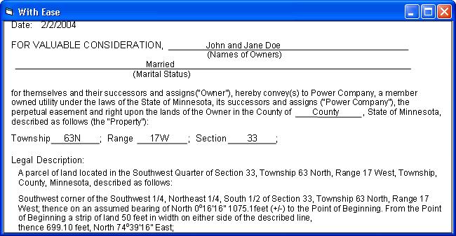
14 Using the GIS System for Storing Easement Information Storing the easement information in the GIS database. Storing the easement information in an external database or Land Information Systems (LIS). Attach scanned easement documents to parcels in the GIS system.

15 Example of Easement Database Transmission Line Easement Parcel Easement Data Stored in the GIS Database

16 Example of Hyperlinked Easement Transmission Line Easement Parcel Display a Hyperlink Scanned Easement
17 Using GIS for Route Planning Developing or acquiring parcel information. Creating proposed route centerline. Create and store alternative routes. Generating a contact list using the final proposed route centerline. Use in conjunction with automated staking software and or easement generation software.
18 Developing or Acquiring Easement Parcels Get Digital Parcel Data from Counties. Make sure that it is usable data Digitize or COGO Parcels from Paper Records. Use GPS and Automated Staking or Easement Generation Software.

19 Example of Defining Proposed Routes Alternative # 3 Alternative # 2 Alternative # 1


20 Example of Generating a Mailing List Generate Mailing List Report from Selected Parcels Select Proposed Route Select Parcels that Intersect Proposed Route

21 Example of Staking/Easement Software The Easement Parcel is Generated Starting Waypoint Additional Waypoints Ending Waypoint Known Monument (Section Corner)

22 Example of Staking/Easement Software
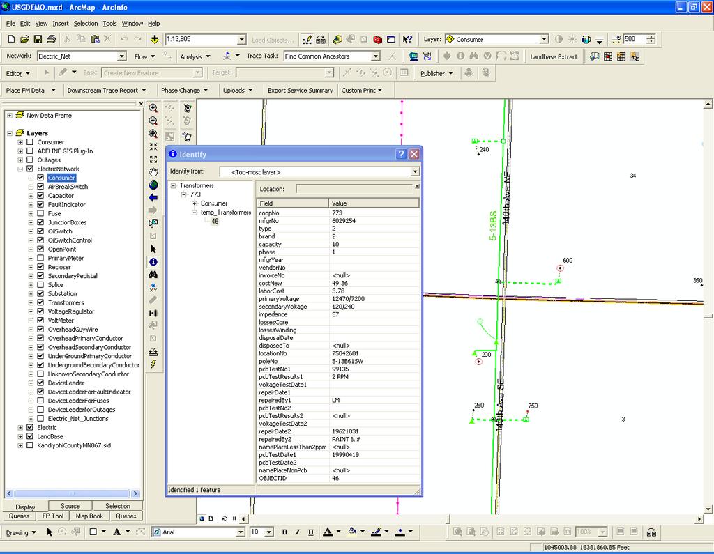
23 PCB and Pole Testing Data PCB test data for transformers and other primary equipment Produce maps that highlight equipment the needs to be changed out Store test data in related tables in the GIS database Pole testing and change out programs Produce maps that highlight pole change out areas and symbolize danger pole so you can dispatch crews to the worst pole first Store Pole test data in a related table in the GIS
24
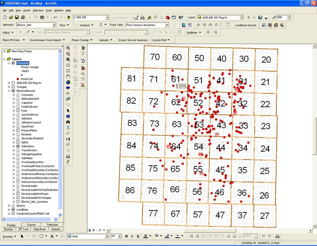
25 Creating Ties to Other Systems Ties to CIS Real time, Near real time, import export and MultiSpeak. Ties to AVL or truck tracking systems For safety and ease of dispatching crews. Ties to Outage Management and Trouble call systems Using Automated Staking systems to maintain the GIS data
26

27 Example of a Trouble Call In this case this Fuse is probable cause of the outage Customer #3 Customer #2 Customer #1
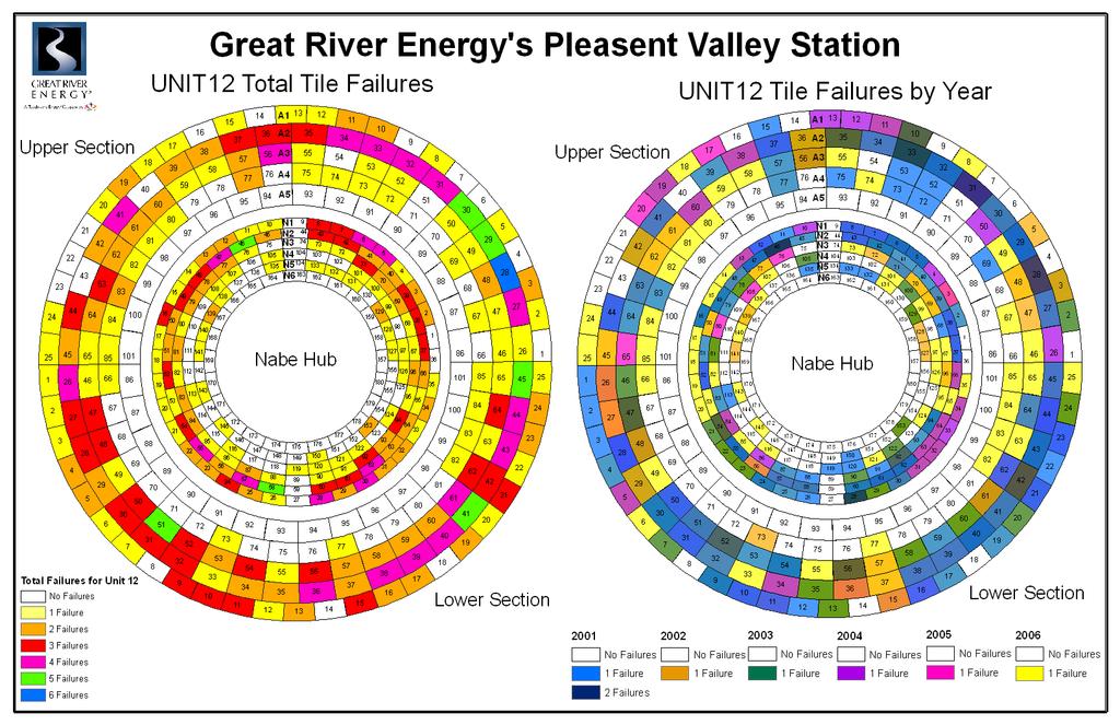
28 Other Uses for GIS Great River Energy is using GIS to track failures in heat shield tiles in combustion turbines. Building cable management. Model substations. Model padmounted switchgear. Anything that has a spatial component and data behind it can be a candidate for GIS.
29
30 Recap GPS Field Inventory ROW and Route Planning PCB and Pole Testing Ties to Other Systems Some Alternative Uses of GIS
31 Thank You!
People, Property and Power Lines. Frequently asked questions about power lines on or near your property
 People, Property and Power Lines Frequently asked questions about power lines on or near your property Great River Energy is a not-for-profit wholesale electric power cooperative which provides electricity
Engineering Load sheet for New Residential Services
 Engineering Load sheet for New Residential Services *Please print clearly* Note: THIS FORM IS NOT AN APPLICATION FOR ELECTRIC SERVICE Full Name*: Date: Email Address*: Mobile Phone*: Mailing Address*:
Reassessment / GIS Project
 Reassessment / GIS Project Harry D. Lindsay, Director Department of Planning & Economic Development June 12, 2008 Background History Project initiated in 2001 Existing parcel maps vs. digital parcel maps
Assessor. Mission Statement: Functions: Long Term Goals: Page 1 of 6
 Assessor Mission Statement: The mission of the Assessor s Office is to create accurate, equitable, and timely property tax assessments to fund public services; and to be a source of current, accurate property
Conservation Plans, Vouchers, & PIRFs
 Conservation Plans, Vouchers, & PIRFs Outline Conservation Plan Preparation Voucher Preparation PIRFs vs. Revision Requests Violations & Veg Guidelines Outline Conservation Plan Preparation Benefits of
R/W PREQUALIFICATION ODOT, 3/14/2018
 R/W PREQUALIFICATION ODOT, 3/14/2018 BRETT SHEARER, C.O. REAL ESTATE PROPOSED RIGHT OF WAY DESIGN 172 PROPOSED RIGHT OF WAY DESIGN PROPOSED RIGHT OF WAY DESIGN Section 3200 Types of Title 173 PROPOSED
New Models for Property Data Verification and Valuation
 New Models for Property Data Verification and Valuation for 2006 IAAO Councils and Sections Joint Seminar May 9-11, 2006 Charleston, South Carolina Presented by George Donatello, CMS Principal Consultant
Directorate of Survey and Mapping NAMIBIA. Cadastral Information System. Vehupisa Kasuko Tjatindi Surveyor Directorate of Survey and Mapping NAMIBIA
 Vehupisa Kasuko Tjatindi Directorate of Survey and Mapping NAMIBIA Tel: +64 61 965000 Directorate of Survey and Mapping NAMIBIA Cadastral Information System Introduction Over the past few decades cadastral
PRIVATE PROPERTY PUBLIC PURPOSE
 PRIVATE PROPERTY PUBLIC PURPOSE Understanding Right-of-Way Acquisition for Transmission Lines At Progress Energy, we are committed to providing safe, reliable and affordable energy to our customers. As
GAUSSCAD A WEBGIS APPLICATION FOR COLLECTING CADASTRAL DATA
 M.M. Moise GaussCAD a WebGIS Application for Collecting Cadastral Data GAUSSCAD A WEBGIS APPLICATION FOR COLLECTING CADASTRAL DATA Mihai-Mircea MOISE, S.C. GAUSS S.R.L., mihai.moise@gauss.ro Abstract:
OPEN-SPACE CONVERSION REQUEST
 OPEN-SPACE CONVERSION REQUEST Applicant: Board Meeting: February 9, 2017 Landowner: Normandy Capital, LLC VOF Easement: BAT-03678 Table of Contents: Cover Page 1 Table of Contents 2 Application Overview
Presented by: Stewart Information International, Inc. Jack McKenna
 Presented by: Stewart Information International, Inc. Jack McKenna Held at the: 2007 ESRI Survey & Engineering GIS Summit San Diego Convention Center San Diego, California June 16-19, 2007 Integrating
City of Surrey s Digital Plan Submission Process
 City of Surrey s Digital Plan Submission Process Cadastral Update Karen Stewart, B.Tech. (GIS) Spatial Information Manager Peter Mueller, B.C.L.S., C.L.S. Survey Manager City of Surrey, British Columbia,
A Geocoded Cadastral Fabric as a Precondition for a Sustainable Land Management System
 A Geocoded Fabric as a Precondition for a Sustainable Land Management System Gottfried KONECNY, Germany; J.P. LAUZON, Canada; Abdul Salam MOHAMMED, India Key words: SDI,, Parcel Boundaries, GPS-GNSS, Land
6.1.4 Discretionary Service Charges (Premises With an AMS-M Meter)
") 6.1.4 Discretionary Charges Applicable: Entire Certified Service Area Effective Date: January 15, 2015 Sheet: 1 Page 1 of 8 Revision: Original 6.1.4 Discretionary Service Charges (Premises With an AMS-M
6.1.4 Discretionary Charges Applicable: Entire Certified Service Area Effective Date: January 15, 2015 Sheet: 1 Page 1 of 8 Revision: Original 6.1.4 Discretionary Service Charges (Premises With an AMS-M
Asset. Capital Asset Management Module. Asset Lookup Form
 Capital Asset Management Module Asset Under KFS Modules, Capital Asset Management, Reference, select the Lookup button in the Asset row. The next screen allows you to search the CAM system for assets that
Cadastral Re-Alignment: Water Corporation approach to spatial data shifting
 Cadastral Re-Alignment: Water Corporation approach to spatial data shifting David Bulfield, Team Leader Spatial Systems Team, Spatial Information Management, Water Corporation (Western Australia) Justin
CATALOGING, MONITORING AND MANAGING INVASIVE SPECIES ON POST LANDS. PSU Geog596A Capstone Proposal Dale Jantzen Dec 17, 2015
 CATALOGING, MONITORING AND MANAGING INVASIVE SPECIES ON POST LANDS PSU Geog596A Capstone Proposal Dale Jantzen Dec 17, 2015 PROJECT OUTLINE AND PURPOSE Define a particular need within a non-profit land
The programme is implemented
 Surveying Property valuation and spatial data tools to assist in land restitution by Jaco de Kock, GISCOE Land and tenure reform in the South African government context are beyond talk and have received
SECTION SITE SURVEYS
 PART 1 - GENERAL 1.1 DESCRIPTION SECTION 02 21 00 SPEC WRITER NOTES: 1. Use this section only for NCA projects. 2. Delete between //---// if not applicable to project. Also delete any other item or paragraph
Government Furnished Property What Is It???
 1 Government Furnished Property What Is It??? Barbara A Finnegan, CPPM CF 2 Government Furnished Property What Is It??? Agenda Introduction Topics Define GFP Acquisition Control of GFP Scheduling: receipt
CHAPTER 5 ZONING SECTION 5.1 PURPOSE
 CHAPTER 5 ZONING SECTION 5.1 PURPOSE The purpose of this Chapter is to regulate the nature and extent of uses of land, and of buildings and structures thereon, in order to promote the purposes of this
MnDOT Contract No Exhibit B. Scope of Work. Scope of Work
 MnDOT Contract No. 1032993 Contract General Description The purpose of this contract is to provide the State with the survey accurate re-establishment of designated Public Land Survey section boundaries
Keys Energy Services Relocation of Electrical Facilities Frequently Asked Questions
 Keys Energy Services Relocation of Electrical Facilities Frequently Asked Questions BACKGROUND As a result of two active hurricane seasons (2004 and 2005), the Florida Public Service Commission (FPSC)
Larimer County Planning & Building Dept. Procedural Guide for NON-RESIDENTIAL DISTRICT SIGNAGE Information and Requirements
 Larimer County Planning & Building Dept. Procedural Guide for NON-RESIDENTIAL DISTRICT SIGNAGE Information and Requirements December 28, 2010 PURPOSE: The purpose of the Sign Code is to protect the health,
Section I General Information
 General Information Table of Contents A. Introduction... I-2 1. Purpose... I-2 2. Scope... I-2 3. Maintenance... I-3 4. Units... I-3 B. Public Relations... I-3 1. General Public... I-3 2. Property Owners...
GOVERNMENT. Case Study Ville de Trois Rivières streamlines property assessment
 GOVERNMENT Case Study Ville de Trois Rivières streamlines property assessment GIS-generated parcel basemap provides powerful visualization & analysis capabilities With a population of just over 130,000,
Functional system for cadastral plans
 , Republic of Macedonia Key words: Cadastre, Digital plans, Data, System SUMMARY The analysis shows that the real estate market in Republic of Macedonia grows daily. With the expansion of this market increases
PREPARING SURVEY TENDER GIS DATABASE OUTCOMES
 PREPARING SURVEY TENDER SPECIFICATIONS FOR PROJECT GIS DATABASE OUTCOMES Presentation by Ian Harper GEODATA AUSTRALIA ESRI User Conference 2009 24 st July 2009 BACKGROUND GIS databases now provide a more
Monitoring Your Lands, Especially Your Conservation Restrictions
 Monitoring Your Lands, Especially Your Conservation Restrictions Matt Cannon, Land Stewardship Coordinator Chatham and Harwich Conservation Trusts Nick Rossi, Conservation Restriction Stewardship Specialist
D-7 SUPPLY. Questions. Type # Topic/Detailed Question How to verify compliance Discpreancy Write up How to Clear
 D-7 SUPPLY Questions Type # Topic/Detailed Question How to verify compliance Discpreancy Write up How to Clear SUI 01 CI 01 SUI 02 Did the unit complete an annual inventory between 1 October and 31 December?
QUESTIONS AND ANSWERS FOR: RFP# 13-34, RFP for Engineering Services for Gas Distribution System Improvements
 QUESTIONS AND ANSWERS FOR: RFP# 13-34, 10-18-13 RFP for Engineering Services for Gas Distribution System Improvements 1. The proposed routing of the high pressure steel gas line appears to follow an existing
Sarpy Transmission Project & La Vista Transmission Project Project Updates. Tim Nissen, PE Director T&D Engineering & Substation August 17, 2017
 Sarpy Transmission Project & La Vista Transmission Project Project Updates Tim Nissen, PE Director T&D Engineering & Substation August 17, 2017 Sarpy Transmission Project (STP) Purpose serve the scheduled
Ownership Data in Cadastral Information System of Sofia (CIS Sofia) from the Available Cadastral Map
 from the Available Cadastral Map") Ownership Data in Cadastral Information System of Sofia (CIS Sofia) from the Available Cadastral Map Key words: ABSTRACT Lydmila LAZAROVA, Bulgaria CIS Sofia is created and maintained by GIS Sofia ltd,
Ownership Data in Cadastral Information System of Sofia (CIS Sofia) from the Available Cadastral Map Key words: ABSTRACT Lydmila LAZAROVA, Bulgaria CIS Sofia is created and maintained by GIS Sofia ltd,
Cloud GIS Real Estate Management, Appraisal and Development Service USING ESRIs ARCGIS SERVER
 Cloud GIS Real Estate Management, Appraisal and Development Service USING ESRIs ARCGIS SERVER INFODIM: Was founded on 1992 and is internationally certified as a GIS company from D&B Dun & Bradstreet Global
MARCH GUIDE TO BUILDING CONDITION ASSESSMENTS and RESERVE FUND STUDIES
 MARCH 2018 GUIDE TO BUILDING CONDITION ASSESSMENTS and RESERVE FUND STUDIES Contents What This Guide Covers... 3 Why Your Co-op Needs a BCA and RFS... 3 The BCA and RFS... 4 What is a building condition
California-Specific Professional Land Surveyor Examination Test Plan
 General Definition of California Professional Land Surveying Practices: The practice of land surveying in the State of California consists of determining, establishing, reporting and mapping the positions,
Land Details. Bridging the Gap between Assessor Acres and GIS Acres
 Land Details Bridging the Gap between Assessor Acres and GIS Acres What are Assessor Acres? It is a legally agreed upon approximation of size Applies to larger parcels Has deep historical roots. Thomas
Across-the-Fence Value and Hostage Occupancy Agreements
 Across-the-Fence Value and Hostage Occupancy Agreements EUCI Conference: Electric Transmission Projects San Diego, California September 19, 2016 John T. Schmick Shenehon Company 2 What is the goal of valuation
SUMMARY OF SIGN REGULATIONS AND PERMIT PROCESS City of Conroe Code of Ordinances Chapter 90, Section 1-15
 Nancy S. Mikeska, Director Chuck Purvis, Certified Building Official SUMMARY OF SIGN REGULATIONS AND PERMIT PROCESS City of Conroe Code of Ordinances Chapter 90, Section 1-15 The City has adopted the International
The GIS Behind Dakota County s FARMLAND AND NATURAL AREAS PROGRAM
 The GIS Behind Dakota County s FARMLAND AND NATURAL AREAS PROGRAM The Farmland and Natural Areas Program is a voluntary program in which Dakota County and other partners work with willing landowners to
2016 LANDU Course Descriptions. Agricultural Land Brokerage and Marketing
 2016 LANDU Course Descriptions Agricultural Land Brokerage and Marketing Gain an understanding of the basics of agricultural land brokerage process s well as insights on how to best market these types
The Newsletter of the Maine Chapter IAAO SPRING Covering Maine Assessing FROM THE EDITOR:
 Covering Maine Assessing The Newsletter of the Maine Chapter IAAO SPRING 2013 FROM THE EDITOR: Maine chapter iaao SPRING 2013 By Kyle Avila, CMA I use GIS daily for explaining valuations to taxpayers in
DEVELOPMENT POLICY INFRASTRUCTURE GUIDELINES FOR NEW DEVELOPMENT
 CITY OF HAYS SUBJECT DEVELOPMENT POLICY INFRASTRUCTURE GUIDELINES FOR NEW DEVELOPMENT ISSUED BY LAST REVISION DATE POLICY MANUAL REVISION DATE City Commission 3-13-08 10-22-09 POLICY STATEMENT: The City
Geo-information for Disaster Management: 9/11 Lessons & Developments Since
 Geo-information for Disaster Management: 9/11 Lessons & Developments Since Michael J. Kevany Senior Vice President PlanGraphics, Inc. mkevany@plangraphics.com Introduction World Trade Center perspective
The Role of the Swedish Land Information System
 The Role of the Swedish Land Information System In the Business Society Tommy Österberg Swedesurvey 1 SWEDEN 9 million inhabitants 450 000 sq. km 21 Counties 291 Municipalities 4.6 million properties in
The Strategic Plan can be viewed by clicking this link.
 What is the purpose of the Land Information Office? Many of Brown County's most basic services rely on accurate and up-to-date land information. Emergency response, resource conservation, infrastructure
Dallas Sloan General Manager Barron Area Phone: (715) Toll Free: Fax: (715) NEW SERVICE PROCESS
 Toll Free: Fax: (715) NEW SERVICE PROCESS") Barron Area Phone: (715) 537-3171 Toll Free: 800-322-1008 Fax: (715) 637-1906 Dallas Sloan General Manager NEW SERVICE PROCESS Paperwork: Membership application social security number required for credit
Barron Area Phone: (715) 537-3171 Toll Free: 800-322-1008 Fax: (715) 637-1906 Dallas Sloan General Manager NEW SERVICE PROCESS Paperwork: Membership application social security number required for credit
NEW DEVELOPMENTS IN THE REAL PROPERTY REGISTER AND CADASTRE IN LITHUANIA
 NEW DEVELOPMENTS IN THE REAL PROPERTY REGISTER AND CADASTRE IN LITHUANIA Jaunius Grigas E-mail: jaunius.grigas@registrucentras.lt Verona, 2008 FUNCTIONS OF STATE ENTERPRISE CENTRE OF REGISTERS Registration
TRI-COUNTY RURAL ELECTRIC COOPERATIVE, INC. POLICY BULLETIN NO. 3-4
 TRI-COUNTY RURAL ELECTRIC COOPERATIVE, INC. POLICY BULLETIN NO. 3-4 SUBJECT: DISTRIBUTION LINE EXTENSIONS I. POLICY: All transmission and distribution line extensions shall be located and designed by the
Historic Environment Scotland
 Historic Environment Scotland 1 of 14 Condition Monitoring System for properties in the care of Scottish Ministers and associated collections. September 2015 2 of 14 Purpose and Scope This document sets
Cadastral Framework Standards
 Cadastral Framework Standards The goal of the Data Standards and Recommendations Committee is to provide recommendations and guidelines to Indiana GIS user communities to facilitate the collection, maintenance
Section 5 SERVICE EXTENSIONS Electric Tariff 1 st Revised Sheet No. 15 Filed with Iowa Utilities Board Cancels Original Sheet No.
 Electric Tariff 1 st Revised Sheet No. 15 Section 5 Extension of Primary, Secondary, and Service Lines (20.2(4) k) & (20.2(4) w) & (20.3(13) 5.1 General This section applies to any extension of the Cooperative
Post Construction Stakeholder Involvement Charles Brown Town of Cary. TOWN Of CARY
 Post Construction Stakeholder Involvement Charles Brown Town of Cary Issues to Address Who are the stakeholders Why the need for continuous stakeholder involvement Construction to Post Construction Process
Cadastral Information System of Sofia
 Alexander LAZAROV and Hristo DECHEV, Bulgaria Key words: ABSTRACT A new Cadastre and Property Register Act (CPRA) was passed in April 2000, setting up rules for the maintenance of these two registers.
FRESHWATER WETLANDS LETTER OF INTERPRETATION (LOI) APPLICATION CHECKLIST AND FEE TABLE (Updated March 2016)
 APPLICATION CHECKLIST AND FEE TABLE (Updated March 2016)") State of New Jersey Department of Environmental Protection Land Use Regulation Program Mail Code 501-02A PO Box 420 Trenton, NJ 08625-0420 Fax# (609)-777-3656 www.nj.gov/dep/landuse/ FRESHWATER WETLANDS
State of New Jersey Department of Environmental Protection Land Use Regulation Program Mail Code 501-02A PO Box 420 Trenton, NJ 08625-0420 Fax# (609)-777-3656 www.nj.gov/dep/landuse/ FRESHWATER WETLANDS
THOMAS CENTER PHYSICAL IMPROVEMENTS
 THOMAS CENTER PHYSICAL IMPROVEMENTS The Thomas Center compound is a well-known public amenity for Gainesville and beyond. It includes two large historic buildings, Thomas Center A and Thomas Center B,
TOWN OF BROOKLINE, NEW HAMPSHIRE
 TOWN OF BROOKLINE, NEW HAMPSHIRE BUILDOUT ANALYSIS DECEMBER, 2003 Prepared by the Nashua Regional Planning Commission TABLE OF CONTENTS Introduction... 1 I. Methodology... 1 A. PARCEL REVIEW... 1 B. DEVELOPMENT
FACT SHEET: Tenure requirements for Major Customer Connections
 FACT SHEET: for Major Customer Connections Purpose February 2014 Version 1.0 This fact sheet describes the types of underlying land tenure required by Ergon Energy in situations where a Major Customer
Egyptian Nationwide Title Cadastre System
 Kholoud SAAD, Egypt Key words: Cadastre, Registration, Urban, Rural, National Cadastre, Automation, reengineering. SUMMARY With growing need for integrated information, Enterprise Solutions has become
DRIVEWAY REQUIREMENTS
 APPLICATION FOR: RESIDENTIAL DRIVEWAY / ACCESS Zoning Review Mail: - 101 White Ave. S.E. - Live Oak, FL 32064 Office: City Hall Annex - 416 Howard Street E - Live Oak, FL 32064 Phone: 386.362.2276 ofc.
Bureau of Land Management MAPPS Federal Update Donald Buhler Cadastral, Lands, and Realty Management April 14, 2015
 Bureau of Land Management MAPPS Federal Update Donald Buhler Cadastral, Lands, and Realty Management April 14, 2015 Division of Cadastral, Lands and Realty Management 1 BLM Mission Manages 247 million
D DAVID PUBLISHING. Mass Valuation and the Implementation Necessity of GIS (Geographic Information System) in Albania
 in Albania") Journal of Civil Engineering and Architecture 9 (2015) 1506-1512 doi: 10.17265/1934-7359/2015.12.012 D DAVID PUBLISHING Mass Valuation and the Implementation Necessity of GIS (Geographic Elfrida Shehu
Journal of Civil Engineering and Architecture 9 (2015) 1506-1512 doi: 10.17265/1934-7359/2015.12.012 D DAVID PUBLISHING Mass Valuation and the Implementation Necessity of GIS (Geographic Elfrida Shehu
Name of Respondent: Date : Page : / Key Informant Interview: Land Tenure
 Key Informant Interview: Land Tenure Note taker Interviewer Entered by Checked by (in database) Original or Copy O C File name Checked by (in the field) Notes on the back of page (s)? Y N Copied? Respondent
QUESTIONNAIRE. 1. Authorizing statute(s) citation West Virginia Code and 11-1C-4(d)
 citation West Virginia Code and 11-1C-4(d)") QUESTIONNAIRE (Please include a copy of this form with each filing of your rule: Notice of Public Hearing or Comment Period; Proposed Rule, and if needed, Emergency and Modified Rule.) DATE: 6/8/15 TO:
QUESTIONNAIRE (Please include a copy of this form with each filing of your rule: Notice of Public Hearing or Comment Period; Proposed Rule, and if needed, Emergency and Modified Rule.) DATE: 6/8/15 TO:
Object Oriented Unified Real Estate Registry for a Good Spatial Data Management
 Object Oriented Unified Real Estate Registry for a Good Spatial Data Management Gyula IVÁN Gábor SZABÓ Zoltán WENINGER Institute of Geodesy, Cartography and Remote Sensing (FÖMI), Hungary Workshop on e-governance,
New Residential Construction Off-Site Conditions Disclosure 5:36-3 NEW RESIDENTIAL CONSTRUCTION OFF-SITE CONDITIONS DISCLOSURE GENERAL PROVISIONS
 5:36-3 NEW RESIDENTIAL CONSTRUCTION OFF-SITE CONDITIONS DISCLOSURE GENERAL PROVISIONS 5:36-3.1 Purposes (a) The purposes of this chapter are as follows: 1. To prescribe the form and manner of submission
Easements, Establishments, Abandonments and Vacations
 Easements, Establishments, Abandonments and Vacations Highway Easements: Where there is a right to construct and maintain a highway facility SH - Standard Highway easement LA - Limited Access Easement
East Coast Positioning Pty Ltd
 East Coast Positioning Pty Ltd PO Box 7388, Baulkham Hills NSW 2153 Phone 0408 556 914 (Mony Seng) ms@ecpsurveyors.com.au Website: www.ecpsurveyors.com.au East Coast Positioning Pty Ltd Page 1 THE COMPANY
Utility networks in Estonian Restrictions Information
 Utility networks in Estonian Restrictions Information System Mr. Priit Kuus Department of Land Cadastre priit.kuus@maaamet.ee +372 675 0843 Tallinn 2011 Restrictions: legal grounds The Constitution of
43 Point Marketing Plan
 1. Pricing. We will assist you with pricing your home based on a comprehensive competitive market analysis. This will help you to set the best price on your home so that it will sell within your time frame.
CERTIFIED SURVEY MAP
 SCONSIN STATE PLANE N:389676.12 E:2130390.15 Center of Section 23 CERTIFIED SURVEY MAP 734.06' THE (PRITCHETTE) ORIGINAL PLAT OF ALL IN THE NW 1 4 OF THE SE 1 4 OF FRACTIONAL SECTION 23, T7N, R9E, IN THE
PRIME COMMERCIAL CORNER
 PROPERTY HIGHLIGHTS DESCRIPTION SITE UNDER CONTRACT + + ±27 Acres available + + Zoned C-2 for Commercial/Retail/Office uses + + Signalized intersection + + Less than one mile from Route 47/I-90 full interchange
Delaware County Transfer Standards
 Delaware County Transfer Standards Delaware County Auditor David A. Yost Delaware County Engineer Chris Bauserman Adopted in 1997, Amended in 1999 Dave Yost County Auditor Chris Bauserman County Engineer
Bureau of Land Management
 Bureau of Land Management MAPPS Federal Update Donald Buhler Cadastral, Lands, and Realty Management April 1, 2014 Division of Cadastral, Lands and Realty Management 1 BLM Mission Manages 247 million surface
FGDC SUBCOMMITTEE FOR CADASTRAL DATA. October 2004 Albuquerque, New Mexico Meeting
 FGDC SUBCOMMITTEE FOR CADASTRAL DATA October 2004 Albuquerque, New Mexico Meeting The National Spatial Data Infrastructure is the means to assemble geographic information that describes the arrangements
The Buyer Consultation: Demonstrating & Articulating Value. Interactive Workshop. Student Workbook
 The Buyer Consultation: Demonstrating & Articulating Value Interactive Workshop Student Workbook The Buyer Consultation: Demonstrating and Articulating your Value What is a Buyer Consultation? What is
REQUEST FOR PROPOSALS FOR SUBSTATION ENGINEERING SERVICES REBUILD OF TYGH VALLEY AND NEW CONSTRUCTION OF EASTSIDE SUBSTATIONS
 REQUEST FOR PROPOSALS FOR SUBSTATION ENGINEERING SERVICES REBUILD OF TYGH VALLEY AND NEW CONSTRUCTION OF EASTSIDE SUBSTATIONS October 1, 2018 Northern Wasco County People s Utility District ( NWCPUD )
The What, Why and How of Project Work Breakdown Structures (WBS)
") PM TUTORIAL The What, Why and How of Project Work Breakdown Structures (WBS) Purpose This document is a guide for understanding, preparing and using a Work Breakdown Structure (WBS) as a part of planning
PM TUTORIAL The What, Why and How of Project Work Breakdown Structures (WBS) Purpose This document is a guide for understanding, preparing and using a Work Breakdown Structure (WBS) as a part of planning
168 Things Your Realtor Does For You...
 168 Things Your Realtor Does For You... Pre-Listing Activities Even before your Irongate Realtor lists your property, they ve been working for you in researching, verifying and preparing your property
Conservancy Mission. Leveraging GIS Technologies in Chesapeake Conservation and Restoration 10/17/2018
 Leveraging GIS Technologies in Chesapeake Conservation and Restoration Rachel Soobitsky Geospatial Project Manager Chesapeake Conservancy Conservation Innovation Center Kristin Kirkwood Executive Director
What We Will Cover. What Governs the Program Services Charges Where to Find Property On-line Search Methods On-site Search Methods
 May 6, 2015 What We Will Cover What Governs the Program Services Charges Where to Find Property On-line Search Methods On-site Search Methods Each State and US Territory has a State Agency for Surplus
IT-SUPPORTED STATE-LAND MANAGEMENT IN A TRANSITIONAL ENVIRONMENT
 IT-SUPPORTED STATE-LAND MANAGEMENT IN A TRANSITIONAL ENVIRONMENT - Examples from Eastern Germany and Mongolia - TOPICS 1 S LAND INFORMATION SYSTEM History and main components IT-strategy and development
Experience in Innovative Technologies Application to Change Urban Space for Sustainable Territory Development
 IOP Conference Series: Materials Science and Engineering PAPER OPEN ACCESS Experience in Innovative Technologies Application to Change Urban Space for Sustainable Territory Development To cite this article:
Development of e-land Administration in Sweden
 Development of e-land Administration in Sweden Roger EKMAN, Sweden Key words: e-land Administration, e-cadastre, delivery times, process development SUMMARY A characteristic of the Swedish cadastral procedure
A Review and Perspective on Parcel Data Models for Urban Planning
 A Review and Perspective on Parcel Data Models for Urban Planning Yiqiang Ouyang Prof. Dr. Ilir Bejleri Department of Urban and Regional Planning University of Florida June 19-21, 2010 1 Content 1. Introduction
Understanding Wind Energy Leases
 Understanding Wind Energy Leases Photo source: Stephanie Buway, OWPI Dr. Shannon L. Ferrell Assistant Professor Agricultural Law OSU Department of Agricultural Economics Power is a function of air density,
Introduction to INRMP Implementation Options
 El Dorado County Integrated Natural Resources Management Plan Introduction to INRMP Implementation Options 1 Our approach to the options evaluation is based on the INRMP components as they are currently
Spatial Data Warehouse Ltd. Cadastral Mapping INITIATIVE 1: CADASTRAL MAPPING. Version Spatial Data Warehouse Ltd. & AltaLIS Ltd.
 Spatial Data Warehouse Ltd. Initiative 1: Cadastral Mapping INITIATIVE 1: CADASTRAL MAPPING 29 P3 The SDW/AltaLIS Model Background The Government of Alberta started a mapping program, the Municipal Integrated
PLAINFIELD CHARTER TOWNSHIP COMMUNITY DEVELOPMENT DEPARTMENT PLANNING, ZONING & BUILDING SERVICES MEMORANDUM
 PLAINFIELD CHARTER TOWNSHIP COMMUNITY DEVELOPMENT DEPARTMENT PLANNING, ZONING & BUILDING SERVICES 6161 BELMONT AVENUE N.E. BELMONT, MI 49306 PHONE 616-364-1190 FAX: 616-364-1170 www.plainfieldchartertwp.org
TOWN OF PALM BEACH. Utility Undergrounding Assessment Methodology Update. June 2, 2017
 TOWN OF PALM BEACH Utility Undergrounding Assessment Methodology Update June 2, 2017 TABLE OF CONTENTS 1. EXECUTIVE SUMMARY... 4 BACKGROUND... 4 2. PROPOSED PUBLIC FACILITIES... 5 FACILITIES... 5 3. BENEFIT
A 7-STEP PROCESS TO ACHIEVE BEST PRACTICES
 INTRODUCTION ONE TWO THREE FOUR FIVE SIX SEVEN SUMMARY CONTACT US A TECHNOLOGY LICENSEE S GUIDE TO TECHNOLOGY ESCROW A 7-STEP PROCESS TO ACHIEVE BEST PRACTICES 1 INTRODUCTION ONE TWO THREE FOUR FIVE SIX
Will County GIS Product Distribution Policy January, 2008
 Will County GIS Product Distribution Policy January, 2008 Background: The goal of this policy is to provide GIS products to users in a reasonable manner and to ensure that products released are of sufficient
GATE OPERATION AND RULES A Users Guide, if you will
 GATE OPERATION AND RULES A Users Guide, if you will 1. Description This manual shall cover the operation and limitations of the entrance gates located on Bucksprings Road and Country Club Road at the entrance
District/ Pepco Soccer Stadium Land Letter of Intent December 27, 2013
 District/ Pepco Soccer Stadium Land Letter of Intent December 27, 2013 The following letter of intent (the " Letter of Intent" ) sets forth the general terms and co nditions under which Potomac Electric
Service Rules Canoochee EMC
 Service Rules Canoochee EMC Amended Version June 19, 2017 P.O. Box 487, 342 E. Brazell St., Reidsville, GA 30453 (800) 342-0134 Fax (912) 557-4396 www.canoocheeemc.com Office Hours Monday-Thursday 8:00
PROPOSAL FOR THE URBAN REAL ESTATE PROPERTY TAX MANAGEMENT DIAGNOSIS IN BRAZIL
 PROPOSAL FOR THE URBAN REAL ESTATE PROPERTY TAX MANAGEMENT DIAGNOSIS IN BRAZIL Marcos A. PELEGRINA and Lia BASTOS Maio de 2009 Geog. Marcos A.. Pelegrina, M.Engº 1 Geog. Marcos A.. Pelegrina, M.Engº 2
Shaping the Cadastral Infrastructure for a Digital Future
 DEPARTMENT OF LANDS PLANNING and the ENVIRONMENT Shaping the Cadastral Infrastructure for a Digital Future Craig Sandy Director Surveys Surveyor General Survey Branch NT Australia Digital Cadastral Databases
DOMINION ENERGY VIRGINIA/DOMINION ENERGY NORTH CAROLINA GUIDELINES FOR USE OF REAL ESTATE ENCUMBERED BY ELECTRIC TRANSMISSION RIGHTS OF WAY
 DOMINION ENERGY VIRGINIA/DOMINION ENERGY NORTH CAROLINA GUIDELINES FOR USE OF REAL ESTATE ENCUMBERED BY ELECTRIC TRANSMISSION RIGHTS OF WAY Revised October 10, 2017 The purpose of these Guidelines is to
2001, A GIS SJ,'ATIALODDESSY. James G. Donahue, L.S. PBS&J,Inc Alton Parkway Irvine, CA 92714
 POSTER SESSIONS 13 2001, A GIS SJ,'ATIALODDESSY James G. Donahue, L.S. PBS&J,Inc. 2501 Alton Parkway Irvine, CA 92714 Biographical Sketch James G. Donahue is a licensed land surveyor in private practice.