National Spatial Data Infrastructure development in Republic of Macedonia
|
|
|
- Ginger Fowler
- 6 years ago
- Views:
Transcription
1 National Spatial Data Infrastructure development in Republic of Macedonia Sonja Dimova, state advisor for geomatics AGENCY FOR REAL ESTATE CADASTRE September 6-th, 2017, Strasbourg
 Article 8 (1) The Agency is authorized to: - Manage the geodetic-cadastre information system; - Perform basic geodetic works; - Perform real property survey; - Perform survey and maintenance")
2 AREC competence for NSDI LAW FOR REAL ESTATE CADASTRE 2013 (Official Gazette of R.M. no. 55 dated ) Article 8 (1) The Agency is authorized to: - Manage the geodetic-cadastre information system; - Perform basic geodetic works; - Perform real property survey; - Perform survey and maintenance of the state borderline; - Perform geodetic works for special purposes - Establish and maintain the real estate cadastre; - Perform mass valuation of real properties registered in the real estate cadastre - Establish and administer the graphic registry of construction land; - Produce topographic maps; - Administration a spatial units register; - Administration graphic registry of streets and house numbers, - Establishing, maintaining and providing public access to the National Spatial Data Infrastructure in compliance to a separate law; - Monitor and supervise the performance of the sole proprietors authorized surveyors and the trade companies for geodetic works. (2) The survey and the maintenance of the state borderline as well as the geodetic works for special purposes of significance to the Republic of Macedonia shall be performed by the Agency. (3) The geodetic works for special purposes stipulated in paragraph 2 of this Article are defined by a Decision enacted by the Government of Republic of Macedonia


3 First NSDI Strategy Define Strategic Mission and Vision Build Business Case Define Governance Structures Legal Framework Interoperability Infrastructure Outreach and Capacity Building NSDI Implementation Roadmap Alignment with European and National Policy Mission and Vision Objectives Guiding Principles Business Requirements Business Model Funding Model Partnering Model Cost Benefit Analysis Political will & engagement NSDI Coordination Body Inter-Ministerial Working Groups Private/public sector engagement INSPIRE Transposition NSDI Regulations Data Sharing Regulations Existing IT Infrastructure Geospatial Data Metadata Interoperability of Spatial Data Network Services Stakeholder Engagement Interoperability Forum Use case development Pilot Applications Training Outline Programme Plan Roles and Responsibilities Performance Monitoring Risk Management Communications Plan Data Sharing Promotional Materials ToR for Government Geoportal Registries Government Geoportal

 2013 -Preparation")
 -Open debate for")


4 2012 Government of R.M. established a WG for preparation of NSDI law (September) Preparation of NSDI law finished (September) -Open debate for NSDI law -Law for NSDI is in Government procedure for adoption (December) Macedonian government adopted the NSDI law -Macedonian parliament adopted the NSDI law NSDI law was amended. Two new members included
 I.")


5 NSDI LAW (Official Gazette of R.M. no.38/2014 and 106/2016 ) I. General provisions II. Metadata III. Interoperability of spatial data sets and services IV. Network services V. Data-sharing VI. Bodies, Coordination and complementary measures VII. Final provisions


6 Article 5 & INSPIRE Annexes 1,2,3 ANNEX 1 Coordinate reference systems; Geographical grid systems; Geographical names; Administrative units; Addresses; Cadastre parcels; Transport networks; Hydrography; Protected sites. ANNEX 2 Elevation; Land cover; Ortho imagery; Geology. ANNEX 3 Statistical units; Buildings; Soil; Land use; Human health and safety; Utility and governmental services; Environmental monitoring facilities; Production and industrial facilities; Agricultural and aquaculture facilities; Population distribution-demography;- Area management/restriction, units-natural risk zones; Atmospheric conditions; Metrological geographical features; Oceanographic geographical features; Sea regions; Bio-geographical regions; Habitats and Biotopes; Species distribution; Energy resources; Mineral resources.


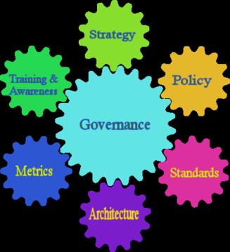

7 REALISED NSDI GOVERNANCE NSDI Council NSDI Committee Working groups Legal Technical Economy PR and awareness


8 Members of the NSDI Council 1. Ministry of Justice 2. Ministry for Defense 3. Ministry of Internal Affairs 4. Ministry of Economy 5. Ministry of Agriculture, Forestry and Water Management 6. Ministry of Local Self - Government 7. Ministry of Culture 8. Ministry of Transport and Communications 9. Ministry of Environment and Spatial Planning 10. Ministry of Information Society and Administration 11. Secretary for implementation of frame agreement 12. State Statistical Office 13. Agency for Real Estate Cadastre 14. Agency for Spatial Planning 15. Central Registry of Republic of Macedonia 16. Center for Crisis Management 17. City of Skopje 18. Economic Chamber of Republic of Macedonia 19. Geological institute of Republic of Macedonia 20. Association of economic chambers of R. Macedonia

9

10


11 GENERAL STRUCTURE Center for crises management City of Skopje Implementation of the national geo-portal -ToR for development and implementation of NSDI geo-portal -Establishment of the NSDI geo-portal Ministry of environment State statistical office


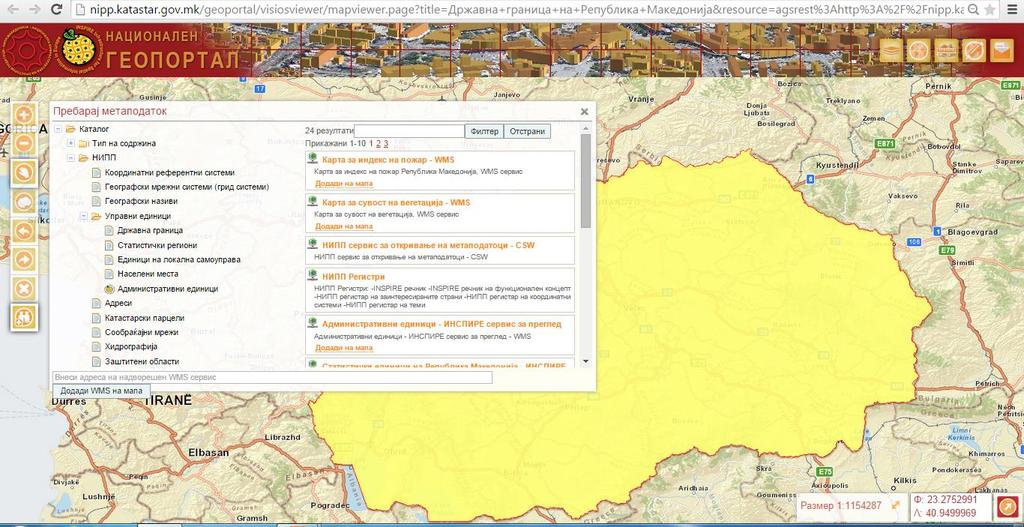
12 National geo-portal Web-based solution which enables searching and publishing of the spatial data and services Has possibility for publication of the geo-spatial data by the all NSDI members A third party with permission can to link his data and services to the portal

13 Functionalities Provides a tool for creating meta data (metadata editor) Search by key words Data catalog E payment for data & services Contains a map viewer application
 Government Agencies")
")
14 Type of users Ministries (internal user-nsdi member) Government Agencies (internal user-nsdi member) External users (third party-private companies and citizen) Administrator
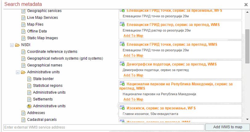
15 Data/services according INSPIRE

16 Data sharing agreement Prepared by legal WG Goal-Easier exchange of data/services Accepted by NSDI Committee NSDI Council gave positive opinion Information sent to the Government of Republic of Macedonia 9 NSDI subjects signed agreement Annex 1 List of datasets and services for which the NSDI Subject is responsible Annex 2 Request for activating/excluding the right of access to datasets exchange

17 Next steps Technical Enrich the number of data and services on the geo-portal Creating an interoperable infrastructure Building capacities for production of updated spatial Data and Services Legal Enlarge the number of signed data sharing agreement Develop bylaws for metadata and network services Protect Data Governance Raising the awareness about NSDI and Informing the stakeholders about the significance of the NSDI and encouraging them to get involved Finance Financial support from the state budget Other models for funding

18 Thank you for your attention
Aspect of preliminary activities in the function of supporting NSDI
 Sonja DIMOVA, Republic of Macedonia Key words: e-governance, geospatial data, NSDI, INSPIRE, metadata SUMMARY The successful establishment of the NSDI in the true sense of the word cannot be performed
Report and update from Working Group A on Core Data
 JOINT UN-GGIM: EUROPE ESS MEETING ON THE INTEGRATION OF STATISTICAL AND GEOSPATIAL INFORMATION LUXEMBOURG 31 MARCH 2017 Report and update from Working Group A on Core Data François Chirié, Dominique Laurent,
Status and Perspectives of the Geodesy, Cartography and Cadastre Authority Availability of Geographic Information in Slovakia.
 Status and Perspectives of the Geodesy, Cartography and Cadastre Authority Availability of Geographic Information in Slovakia Hedviga Májovská Geodesy, Cartography and Cadastre Authority of the Slovak
Croatian SDI: a Tool for Accelerated Development of the Geo-Conscious Society
 STATE GEODETIC ADMINISTRATION Croatian SDI: a Tool for Accelerated Development of the Geo-Conscious Society Prof.Dr.Sc. Željko Bačić, Mr.Sc. Ljerka Rašić FIG Working Week 2009 - Surveyors Key Role in Accelerated
AREC responsibilities, data and registries and the way of their distribution
 Data as a basis of the digital society PCC, 13-15 March 2018, Sofia AREC responsibilities, data and registries and the way of their distribution Vlatko Dimovski Agency for Real Estate Cadastre (AREC) the
Use of data in Ukraine for sustainable economic growth. Oleksandr Maliuk State Service of Ukraine for Geodesy, Cartography and Cadastre
 Use of data in Ukraine for sustainable economic growth Oleksandr Maliuk State Service of Ukraine for Geodesy, Cartography and Cadastre Kehl, 2017 Content of the presentation Ukraine & StateGeoCadastre:
INTEGRATED LAND ADMINISTRATION SYSTEM PROJECT PREPARATION (IBRD Advance no. P459-HR) TERMS OF REFERENCE
 TERMS OF REFERENCE") INTEGRATED LAND ADMINISTRATION SYSTEM PROJECT PREPARATION (IBRD Advance no. P459-HR) TERMS OF REFERENCE SERVICE PROVISION FOR THE SUPPORT TO THE NATIONAL SPATIAL DATA INFRASTRUCTURE (NSDI) DEVELOPMENT
INTEGRATED LAND ADMINISTRATION SYSTEM PROJECT PREPARATION (IBRD Advance no. P459-HR) TERMS OF REFERENCE SERVICE PROVISION FOR THE SUPPORT TO THE NATIONAL SPATIAL DATA INFRASTRUCTURE (NSDI) DEVELOPMENT
Croatian NSDI - An example of AGISEE country web-page. Vlado Cetl and Miljenko Lapaine
 Croatian NSDI - An example of AGISEE country web-page Vlado Cetl and Miljenko Lapaine Introduction 2/18 Guidelines AGISSE Country Pages should provide an overview of the situation of SDIs in the countries
LIS a motivation for SDI initiative
 Eric Mwaikambo Ardhi University Dar es Salaam Tanzania Overview Status of LIS in Tanzania Relationship between SDI and LIS Spatial Standards LIS a motivation for SDI initiative Conclusion & Recommendations
Quality Improvement of the Real Estate Cadastre in Serbia
 , Serbia Key words: quality improvement, real estate information, quality assurance, Serbia SUMMARY The concept of cadastral modernization in the Republic of Serbia was defined in 1992, and it is being
Meeting the Changing National Geospatial Information Needs. Palitha Udayakantha Surveyor General - Sri Lanka
 Meeting the Changing National Geospatial Information Needs Palitha Udayakantha Surveyor General - Sri Lanka Sri Lanka Location Latitude 5 55 10-9 50 6 North Longitude 79 31 19-81 52 36 East Area 65610
Role of Republic Geodetic Authority in the Serbian geo-sector
 Role of Republic Geodetic Authority in the Serbian geo-sector Republic Geodetic Authority, Serbia www.rgz.gov.rs EuroGeographics General Assembly 2014 Moldova, Chisinau, 28 th 30 th September 2014 The
Land Administration In Public Private Partnerships
 Land Administration In Public Private Partnerships Workshop Customers - Co-operation - Services Vienna, 12-13 September 2002 Peter Creuzer Content Land Administration - Tasks History Spatial Data Infrastructure
CONTACT LOCATIONS OF THE PUBLIC-PRIVATE RELATIONSHIP IN THE GEODETIC AND CADASTRE FILDS
 ISSN: 1857-9000, EISSN: 1857-9019 CONTACT LOCATIONS OF THE PUBLIC-PRIVATE RELATIONSHIP IN THE GEODETIC AND CADASTRE FILDS Ljubisha KITANOVSKI 1 UDC: 347.235:349.418]:[334.7:528.44(497.7) ABSTRACT Geodetic
NSDI assessment for the Netherlands
 for the Netherlands Ruby Beltman, Geonovum May 24 2007 Presentation the Dutch public geo-information playing field Geonovum and the Dutch NSDI need for results The Dutch public geo-information playing
Marine Spatial Data Infrastructure (MSDI) & The Marine Cadastre Application. April 10, 2018
 & The Marine Cadastre Application. April 10, 2018") Marine Spatial Data Infrastructure (MSDI) & The Marine Cadastre Application April 10, 2018 A Collaborative Pilot Project Vision of CHS: A framework of geographic data, metadata, users and tools Intent
Marine Spatial Data Infrastructure (MSDI) & The Marine Cadastre Application April 10, 2018 A Collaborative Pilot Project Vision of CHS: A framework of geographic data, metadata, users and tools Intent
International funding projects in Republic Geodetic Authority
 International funding projects in Republic Geodetic Authority Serbia: Republic Geodetic Authority Workshop Exploring Funding Instruments for NMCA 7-8 November 2012 Republic Geodetic Authority Republic
KEY REGISTERS AS BASE OF THE DUTCH SDI
 CO-151 KEY REGISTERS AS BASE OF THE DUTCH SDI BAKKER N.J. Kadaster, APELDOORN, NETHERLANDS This paper reports on the realisation of the Key Registers in the Netherlands as the foundation of the Dutch National
Building Integrated Land Information Systems and Development of NSDI
 Stig JÖNSSON, Sweden Key words: Land administration, land information systems, property formation, spatial data infrastructure, Inspire, institutional cooperation SUMMARY Lantmäteriet the Swedish agency
Egyptian Nationwide Title Cadastre System
 Kholoud SAAD, Egypt Key words: Cadastre, Registration, Urban, Rural, National Cadastre, Automation, reengineering. SUMMARY With growing need for integrated information, Enterprise Solutions has become
Building a national SDI. Approach and strategy in The Netherlands
 Agenda 1. NSDI vision and implementation strategy 2. NSDI playing field 3. Standards framework for the NSDI 4. National SDI components for IM Information model public safety SDI Portal for public safety
Presented at the FIG Working Week 2016, May 2-6, 2016 in Christchurch, New Zealand
 Presented at the FIG Working Week 2016, May 2-6, 2016 in Christchurch, New Zealand The IMPULS Project Is a Project About Cooperation, Coordination, Transparency and Data Sharing A SDI project in the Western
Cadastre and Land Registration in Europe
 Annex A: Questionnaire 2007 for Information Resource Cadastre and Land Registration in Europe Introduction This questionnaire is based on the EuroGeographics vision document 'Cadastre and Land Registration
Serbia Should Have Online Cadastre for Property Like Other Countries in the Region
 Serbia Should Have Online Cadastre for Property Like Other Countries in the Region Tamara Borovcanin USAID Business Enabling Project The online real estate registry allows citizens to quickly and easily
Land and Geographic Information, an Important Part of the Infrastructure in Sweden
 Land and Geographical Information Land and Geographic Information, an Important Part of the Infrastructure in Sweden Land and Geographic Information, an Important Part of the Infrastructure In Sweden Bo
Functional system for cadastral plans
 , Republic of Macedonia Key words: Cadastre, Digital plans, Data, System SUMMARY The analysis shows that the real estate market in Republic of Macedonia grows daily. With the expansion of this market increases
Cadastral Parcels in the context of INSPIRE
 Cadastral Parcels in the context of INSPIRE Gyula IVÁN Institute of Geodesy, Cartography & Remote Sensing, HUNGARY Open Symposium on Environment and Land Administration Big Works for the Defence of Territory
Challenges for the multi purpose cadastre
 Jens RIECKEN, Markus SEIFERT, Germany Key words: Multi purpose cadastre, 3d-cadastre, land use, SDI, solar cadastre SUMMARY Over the past 30 years, with the progress of information technologies the development
PROJECT INFORMATION DOCUMENT (PID) CONCEPT STAGE Report No.: AB3229 Project Name. Land Registry and Cadastre Modernization Project Region
 CONCEPT STAGE Report No.: AB3229 Project Name. Land Registry and Cadastre Modernization Project Region") PROJECT INFORMATION DOCUMENT (PID) CONCEPT STAGE Report No.: AB3229 Project Name Land Registry and Cadastre Modernization Project Region EUROPE AND CENTRAL ASIA Sector Central government administration
PROJECT INFORMATION DOCUMENT (PID) CONCEPT STAGE Report No.: AB3229 Project Name Land Registry and Cadastre Modernization Project Region EUROPE AND CENTRAL ASIA Sector Central government administration
OFFICIAL DOCUMENTS. Financing Agreement. Public Disclosure Authorized CREDIT NUMBER 6306-MD. Public Disclosure Authorized
 Public Disclosure Authorized Public Disclosure Authorized OFFICIAL DOCUMENTS Financing Agreement (Land Registration and Property Valuation Project) CREDIT NUMBER 6306-MD Public Disclosure Authorized between
GLOBAL GEOSPATIAL MANAGEMENT INFORMATION
 GLOBAL GEOSPATIAL MANAGEMENT INFORMATION SEOUL, KOREA 24 th to 26 th October 2011 COUNTRY REPORT - REPUBLIC OF BOTSWANA 1. INTRODUCTION 1.1. SOCIAL, ECONOMIC AND POLITICAL BACKGROUND Botswana attained
Participants of the Ministerial Meeting on Housing and Land Management on 8 October 2013 in Geneva
 Summary At its meeting on 2 April 2012, the Bureau of the Committee on Housing and Land Management of the United Nations Economic Commission for Europe agreed on the need for a Strategy for Sustainable
ABSTRACT Land Administration System in Lithuania
 ABSTRACT Land Administration System in Lithuania 1. General introduction to the Lithuanian Land Administration System and State Enterprise Centre of Registers ( shortly SECR) Lithuania has established
Spatial Data Infrastructure in Sweden
 Spatial Data Infrastructure in Sweden Hans-Erik WIBERG, Sweden Key words: ABSTRACT Sweden was one of the first countries to address Data Infrastructure matters and have during several decades developed
Integration of Public Service Procedures and Use of Cadastral Data
 Integration of Public Service Procedures and Use of Cadastral Data Signe Rudzite Head of Cadastre and Register Department The State Land Service Vilnius, 21.10.2013 Content General information Current
INSPIRE implementation as a link between egovernment and environmental purposes
 INSPIRE implementation as a link between egovernment and environmental purposes Jiří Poláček Czech Office for Surveying, Mapping and Cadastre (ČÚZK) What s to Come Role of ČÚZK branch in the INSPIRE implementation.
Digitalisation of the Real Property Rights Towards Spatially enabled E-Government
 Digitalisation of the Real Property Rights Towards Spatially enabled E-Government Lise Schroeder, Bent Hulegaard Jensen, Esben Munk Soerensen & Line Hvingel Istanbul, Turkey 25 june 201 Overview Introduction
Seventh Session of the United Nations Committee of Experts on Global Geospatial Information Management
 Report of the Forum P a g e 1 Seventh Session of the United Nations Committee of Experts on Global Geospatial Information Management Report of the Forum Secure Land Rights and Smart Cities - Making It
The Croatian Surveyor Guaranteeing Land Property
 Croatian Chamber of Chartered Geodetic Engineers Zagreb, Croatia www.hkoig.hr The Croatian Surveyor Guaranteeing Land Property Ph. D. Danko Markovinović The Cadastral Surveyor paving the Way to the Future
Implementation Status & Results Croatia Integrated Land Administration System Project (P122219)
") Public Disclosure Authorized Public Disclosure Authorized The World Bank Implementation Status & Results Croatia Integrated Land Administration System Project (P122219) Operation Name: Integrated Land
Public Disclosure Authorized Public Disclosure Authorized The World Bank Implementation Status & Results Croatia Integrated Land Administration System Project (P122219) Operation Name: Integrated Land
Land Administration and Spatial Enablement Victoria s Experience. Chris McRae, Executive Director Land Victoria
 Land Administration and Spatial Enablement Victoria s Experience Chris McRae, Executive Director Land Victoria 4 th UN Land Administration Forum, October 2011 Outline About Land Victoria Land Victoria
Slovenian Experiences
 Slovenian Experiences An example from a transition country Milan Brajnik, B.Sc.Geod., Assistant Director milan.brajnik@geod-is.si Geodetic Institute of Slovenia 1000 Ljubljana, Jamova cesta 2 The Identity
Importance of Spatial Data Infrastructure in the UNECE Region. Amie Figueiredo INSPIRE Conference 2016 Barcelona, 26 September 2016
 Importance of Spatial Data Infrastructure in the UNECE Region. Amie Figueiredo INSPIRE Conference 2016 Barcelona, 26 September 2016 United Nations Economic Commission for Europe 56 member States in Europe,
SECTOR PUBLIC CADASTRES AND REGISTERS MARKET PARTICIPANTS
 E-SERVICES TO CITIZENS, GOVERNMENT AND BUSINESSES. LITHUANIA EXPERIENCE Arvydas Bagdonavičius State Enterprise Centre of Registers Arvydas.Bagdonavicius@registrucentras.lt REGISTERS AND IS MANAGED BY THE
EXPANDING AVAILABILITY OF BROADBAND ACCESS AND ADOPTION
 Single point information Ilija Kepevski Agency for Electronic Communications Regional Conference for Europe EXPANDING AVAILABILITY OF BROADBAND ACCESS AND ADOPTION 28-29 September 2015 - Budva, Montenegro
Content. Development and Potential for Improvements of the Austrian Land Administration System. Introduction. Dynamic Framework of Land Administration
 Development and Potential for Improvements of the Austrian Land Administration System Reinfried MANSBERGER, BOKU Vienna Gerhard MUGGENHUBER, BEV Vienna Gerhard NAVRATIL, TU Vienna Christoph TWAROCH, TU
The Role of National Mapping and Cadastre Agencies in Establishment of NSDI: Croatian Example
 The Role of National Mapping and Cadastre Agencies in Establishment of NSDI: Croatian Example Ljerka RAŠIĆ and Željko BAČIĆ, Croatia Key words: spatial data infrastructure, NSDI, NMCA, Inspire SUMMARY
Building a European Spatial Data Infrastructure: The Role of EuroGeographics
 Building a European Spatial Data Infrastructure: The Role of EuroGeographics Richard Kirwan President of EuroGeographics 1st Congress on Cadastre in the EU 1 Presentation overview EuroGeographics - the
DATR towards e-land Administration in Hungary
 DATR towards e-land Administration in Hungary Gyula IVÁN-Gábor SZABÓ-Zoltán WENINGER-Piroska Zalaba Institute of Geodesy, Cartography and Remote Sensing, Budapest, HUNGARY XXIV. FIG Congress Facing the
INSPIRE implementation as a link between egovernment and environmental purposes
 INSPIRE implementation as a link between egovernment and environmental purposes Jiří Poláček Czech Office for Surveying, Mapping and Cadastre (ČÚZK) Agenda Role of ČÚZK branch in the INSPIRE implementation.
Property Transactions in the Digital Age. The Property Cadastre in the Context of Spatial. Dr. Jens Riecken, NRW Ministry of the Interior
 Property Transactions in the Digital Age The Property Cadastre in the Context of Spatial Data Infrastructure (SDI) Dr. Jens Riecken, NRW Ministry of the Interior Property Transactions in the Digital Age
Mainstreaming of the National Land Consolidation Programme (MAINLAND)
") Mainstreaming of the National Land Consolidation Programme (MAINLAND) Vilma Daugaliene FAO Chief Technical Advisor 19 June 2018, Skopje 1 General information about the Project Duration: 1 March 2017 31
Mainstreaming of the National Land Consolidation Programme (MAINLAND) Vilma Daugaliene FAO Chief Technical Advisor 19 June 2018, Skopje 1 General information about the Project Duration: 1 March 2017 31
LAND REGISTRATION SYSTEM OF THE REPUBLIC OF CROATIA
 "On the last day of the Creation God desired to crown His work, and thus created Kornati Islands out of tears, stars and breath." (George Bernard Shaw) LAND REGISTRATION SYSTEM OF THE REPUBLIC OF CROATIA
Recent development in Land Administration in the Czech Republic
 Recent development in Land Administration in the Czech Republic Contribution to discussion prepared by the Czech delegation 5th session of UNECE WPLA Item 3 of agenda Geneva, 19-20 November 2007 Czech
Designing for transparency and participation in the Hellenic Cadastral Project
 Designing for transparency and participation in the Hellenic Cadastral Project Dr. Dimitris Rokos Director of Planning and Investments, Hellenic National Cadastre and Mapping Agency S.A. Table of Contents
Greetings from Denmark. Property Rights, Restrictions and Responsibilities - A Global Land Management Perspective. Wonderful Copenhagen
 Property Rights, Restrictions and Responsibilities - A Global Land Management Perspective Greetings from Denmark 43,000 sq km Prof. Stig Enemark President Aalborg University, Denmark Aalborg Copenhagen
Unified Land Administration for a Better Spatial Infrastructure
 Unified Land Administration for a Better Spatial Infrastructure Gyula IVÁN Institute of Geodesy, Cartography & Remote Sensing FÖMI (HUNGARY) Open Symposium 30th Korean Cadastral Seminar & FIG Commission
PROJECT INFORMATION DOCUMENT (PID) APPRAISAL STAGE Report No.: PIDA Project Name. Region Country Sector(s) Theme(s)
 APPRAISAL STAGE Report No.: PIDA Project Name. Region Country Sector(s) Theme(s)") Public Disclosure Authorized Public Disclosure Authorized Public Disclosure Authorized Public Disclosure Authorized Project Name Region Country Sector(s) Theme(s) Lending Instrument Project ID Borrower(s)
Public Disclosure Authorized Public Disclosure Authorized Public Disclosure Authorized Public Disclosure Authorized Project Name Region Country Sector(s) Theme(s) Lending Instrument Project ID Borrower(s)
BY THE GRACE OF GOD ALMIGHTY MINISTER OF ENERGY AND MINERAL RESOURCES
 DEPARTMENT OF ENERGY AND MINERAL RESOURCES REPUBLIC OF INDONESIA REGULATION OF MINISTER OF ENERGY AND MINERAL RESOURCES NUMBER 02 YEAR 2009 CONCERNING GUIDANCE IN THE ASSIGNMENT OF GEOTHERMAL PRELIMINARY
BULGARIAN CADASTRE A GUARANTEE FOR THE OWNERSHIP RIGHTS IN IMMOVABLE PROPERTIES
 4 TH INTERNATIONAL CONFERENCE RECENT PROBLEMS IN GEODESY AND RELATED FIELDS WITH INTERNATIONAL IMPORTANCE February 28 - March 2, 2007, Inter Expo Centre, Sofia, Bulgaria BULGARIAN CADASTRE A GUARANTEE
E fficient L and A dministr ation E ncour ages P r oper ty M ar k ets. surveying companies at Project commencement. Key Messages
 Secur ing Pr oper ty R ights and I ncr easing R eal E state Pr oductivity in F Y R M acedonia Victoria Stanley, Denis Boskovski and Samantha De Martino Key Messages Before 2005, FYR Macedonia did not have
STATUS REPORT
 Working Group 3 Land Administration STATUS REPORT 2006-2009 2009 Prof Ian Williamson (Chair) Mr Ahmad Fauzi Nordin (Vice Chair) Assoc. Prof Abbas Rajabifard (Vice Chair) 18th UNRCC-AP Conference Bangkok
Information contained
 Government Information (Public Access) Act 2009 (GIPA Act) LPI Information Guide 1. Introduction and contents of this guide The Land and Property Information s (LPI) Information Guide tells you in general
TERMS OF REFERENCE FOR CONSULTANCY SERVICES TO PREPARE PROJECT DOCUMENT FOR CADASTRAL MAPPING IN THE GAMBIA
 Ministry of Lands and Regional Government United Nations Development Program UNDP April 2017 TERMS OF REFERENCE FOR CONSULTANCY SERVICES TO PREPARE PROJECT DOCUMENT FOR CADASTRAL MAPPING IN THE GAMBIA
Cadastre: definitions
 Introduction New vision towards a multipurpose cadastral system to support land management in Morocco Moha EL-AYACHI, El Hassane SEMLALI, Mohamed ETTARID, Driss TAHIRI, Institut Agronomique et Vétérinaire
Republic of Bulgaria
 Geodesy, Cartography and Cadastre Agency Republic of Bulgaria www.cadastre.bg 24. 01. 2018 г., гр. София The Cadastre Legislation in Bulgaria - historical reference 1908 г. The Cadastre Act The objective
PROTOCOL ASDI ARCTIC SPATIAL DATA INFRASTRUCTURE PROJECT KICK-OFF MEETING
 1(9) Friday, 15 October 2010 PROTOCOL ASDI ARCTIC SPATIAL DATA INFRASTRUCTURE PROJECT KICK-OFF MEETING Point of time: 09.00 October 14 11.15 October 15, 2010 Locality: Rue du Nord 76, 1000 Brussels, BELGIUM
1st Regional INSPIRE Forum 4th Croatian NSDI and INSPIRE Day
 1st Regional INSPIRE Forum 4th Croatian NSDI and INSPIRE Day State of Play EULIS Rik Wouters Managing Director EULIS Programme What is EULIS EULIS is renewed: LINE For who is EULIS? Why EULIS? Projects
Report No.: ISDSA15389
 Public Disclosure Authorized Public Disclosure Authorized Public Disclosure Authorized Public Disclosure Authorized 0 o Date ISDS Prepared/Updated: 12-ct-2015 INTEGRATED SAFEGUARDS DATA SHEET APPRAISAL
Land Administration Developments in Rwanda
 Land Administration Developments in Rwanda Eugène RURANGWA Expert Group Meeting on secure land tenure new legal frameworks and tools UN-Gigiri, Nairobi, 10-12 November, 2004 Contents Somme figures about
FIG Commission 3 Spatial Information Management. Report of Activities 2009
 Appendix to item 10.3 Report to the 33 rd General Assembly FIG Congress in Sydney, Australia 2010 FIG Commission 3 Spatial Information Management Report of Activities 2009 1. General Since 2007, FIG Commission
New Developments in the Hellenic Cadastre
 New Developments in the Hellenic Cadastre Prof. M. Kavouras Vice-president Ktimatologio S.A. (Hellenic Cadastre) The Hellenic Cadastre Background The Hellenic National Cadastre Organizational and institutional
Proposals for Best Practice
 WPLA Fees & Charges in Cadastre and Registration Proposals for Best Practice Neil King United Kingdom WPLA Fees and Charges Study Best Practice This presentation offers an overview of a draft report that
Amie Figueiredo WPLA Secretariat Wednesday, 16 October 2014 Vienna, Raiffeisen Forum
 WPLA cooperation with related international organisations and interregional cooperation Amie Figueiredo WPLA Secretariat Wednesday, 16 October 2014 Vienna, Raiffeisen Forum International cooperation International
Scenic Nepal. Land Administration Systems. Outline of Presentation. Interests in land. Rights: Registration and security of tenure positions
 Scenic Nepal Land Administration Systems Managing Rights, Restrictions, and Responsibilities in Land Prof. Stig Enemark President Aalborg University, Denmark SURVEY DEPARTMENT KATHMANDU, NEPAL. 16 FEBRUARY
Implementation Status & Results Macedonia, former Yugoslav Republic of Real Estate Cadastre & Registration Project (P083126)
") Public Disclosure Authorized Public Disclosure Authorized Implementation Status & Results Macedonia, former Yugoslav Republic of Real Estate Cadastre & Registration Project (P083126) Operation Name: Real
Public Disclosure Authorized Public Disclosure Authorized Implementation Status & Results Macedonia, former Yugoslav Republic of Real Estate Cadastre & Registration Project (P083126) Operation Name: Real
MINISTRY OF LANDS, HOUSING AND URBAN DEVELOPMENT CLIENTS CHARTER 2017/ /21
 MINISTRY OF LANDS, HOUSING AND URBAN DEVELOPMENT CLIENTS CHARTER 2017/18 2020/21 July, 2017 1 Table of Contents 1.0 INTRODUCTION 1.1 The Ministry s Vision 1.2 The Ministry s Mission 1.3 The Ministry s
Overview of PCGIAP-WG3 and Spatially Enabled Government
 Working Group 3 3 rd Land Administration Forum Overview of and Spatially Enabled Government Abbas Rajabifard Vice Chair, Established in 2000 based on a Resolution from the 15th UNRCC-AP in Malaysia. With
Recent development in land consolidation in Macedonia and land valuation issues
 Recent development in land consolidation in Macedonia and land valuation issues EMERALD(2008-2009)-Encouraging Macedonia s Endeavours to Rural Land Development and STIMERALD(2010-2012) Origin of Emerald
An Overview of the eplan Journey with a Focus on the Victorian eplan 2025 Roadmap Dr Hamed Olfat
 An Overview of the eplan Journey with a Focus on the n eplan 2025 Roadmap Dr Hamed Olfat eplan Coordinator Land Use Chairman of Technical Committee ICSM eplan Working Group Outline eplan Overview ICSM
Procedures for the legalization and registration of buildings and building units Challenges and Problems Building cadastre in Slovenia
 Procedures for the legalization and registration of buildings and building units Challenges and Problems Building cadastre in Slovenia Edvard Mivšek M.Sc. Geodetic institut of Slovenija Pristina, 19 April
The World Bank Integrated Land Administration System Project (P122219)
") Public Disclosure Authorized EUROPE AND CENTRAL ASIA Croatia Social, Urban, Rural and Resilience Global Practice Global Practice IBRD/IDA Investment Project Financing FY 2012 Seq No: 14 ARCHIVED on 07-Dec-2017
Public Disclosure Authorized EUROPE AND CENTRAL ASIA Croatia Social, Urban, Rural and Resilience Global Practice Global Practice IBRD/IDA Investment Project Financing FY 2012 Seq No: 14 ARCHIVED on 07-Dec-2017
The New Swiss Law on Geoinformation and the Ordinance. on thecadastre on Public Law Restrictions (4064)
") on thecadastre on Public Law Restrictions (4064) 1. INTRODUCTION 2. STARTING CONDITIONS 3. TIME FRAME 4. RESULTs OF THE WORK 5. CONTENT OF THE ACT ON GEOINFORMATION 6. CADASTRE OF THE PUBLIC-RIGHT RESTRICTIONS
on thecadastre on Public Law Restrictions (4064) 1. INTRODUCTION 2. STARTING CONDITIONS 3. TIME FRAME 4. RESULTs OF THE WORK 5. CONTENT OF THE ACT ON GEOINFORMATION 6. CADASTRE OF THE PUBLIC-RIGHT RESTRICTIONS
HOUSING AND PROPERTY MARKET IN LITHUANIA CONTENTS
 HOUSING AND PROPERTY MARKET IN LITHUANIA Kęstutis Sabaliauskas, Director General State Enterprise Centre of Registers, Lithuania Kestutis.Sabaliauskas@registrucentras.lt CONTENTS Legal environment Real
INSPIRE Thematic Working. Cadastral parcels. September 2008
 INSPIRE Thematic Working Cadastral parcels September 2008 The INSPIRE context The INSPIRE Directive Its aim is to build the INfrastructure for Spatial InfoRmation in Europe The INSPIRE Directive has been
Agenda. Introduction to participants First Meeting UN-GGIM - GROUP OF EXPERTS ON LAND ADMINISTRATION AND MANAGEMENT UN-GE-LAM
 First Meeting UN-GGIM - GROUP OF EXPERTS ON LAND ADMINISTRATION AND MANAGEMENT Kees de Zeeuw, The Netherlands Chair Mahashe Chaka, Lesotho Co-Chair Brent Jones, ESRI (USA) -Rapporteur Agenda Opening Introduction
The World Bank Modernization of Real Property Registration and Cadastre (P151746)
") Public Disclosure Authorized EUROPE AND CENTRAL ASIA Uzbekistan Social, Urban, Rural and Resilience Global Practice Global Practice IBRD/IDA Investment Project Financing FY 2016 Seq No: 5 ARCHIVED on 23-Apr-2018
Public Disclosure Authorized EUROPE AND CENTRAL ASIA Uzbekistan Social, Urban, Rural and Resilience Global Practice Global Practice IBRD/IDA Investment Project Financing FY 2016 Seq No: 5 ARCHIVED on 23-Apr-2018
Surveying in Austria. Congress Maanmittauspäivät Seinäjoki, 20 th March 2014
 Surveying in Austria Congress Maanmittauspäivät Seinäjoki, 20 th March 2014 Topics Facts, figures Organisational issues of surveying Role of the BEV Products, services The Cadastre Surveying Education
Land Administration and Management in Nepal" Krishna Raj B.C. Joint Secretary Ministry of Land Reform and Management Nepal
 Land Administration and Management in Nepal" Krishna Raj B.C. Joint Secretary Ministry of Land Reform and Management Nepal Presentation Outline Country Context Current Situation Available Infrastructure
10/2/2018. Fit for Purpose Continuum of rights -with GLTN UN Habitat Land Administration Domain Model Sharing of knowledge Network of Experts
 Thanks to FIG FIG Fit for Purpose Continuum of rights -with GLTN UN Habitat Land Administration Domain Model Sharing of knowledge Network of Experts 1 Norwegian support to projects abroad and the role
THE XXV FIG INTERNATIONAL CONGRESS IN MALAYSIA Kuala Lumpur, Malaysia, June 2014 at Kuala Lumpur Convention Centre
 CALL FOR PAPERS TO THE XXV FIG INTERNATIONAL CONGRESS IN MALAYSIA Kuala Lumpur, Malaysia, 16 21 June 2014 at Kuala Lumpur Convention Centre Dear Friend and Colleague, It is our privilege and honour to
Cadastre A Vision on Future Cadastral Systems
 Cadastre 2014 - A Vision on Future Cadastral Systems Jürg Kaufmann - 1 - CONTENTS ABOUT FIG ENVIRONMENT FOR THE DEVELOPMENT OF CADASTRE 2014 DEVELOPMENT OF CADASTRE 2014 PRINCIPLES OF CADASTRE 2014 EFFECTS
Improvement of Effectiveness Present Developments in Hungarian Land Administration
 Improvement of Effectiveness Present Developments in Hungarian Land Administration Gyula IVÁN and András OSSKÓ, Hungary Key words: Land Administration, Cadastre, Land Registry SUMMARY New Act on Surveying
Hungary is a landlocked, Central European country in the Carpathian Basin
 Brief Overview on Hungarian Land Administration MSc. György Domokos Hungarian Geodetic Surveying Liaison Group CLGE GA Hannover 12 13 October 2012 Hungary is a landlocked, Central European country in the
Performance Information for Appropriations
 Performance Information for Appropriations Vote Lands MINISTER(S) RESPONSIBLE FOR APPROPRIATIONS: Minister for Land Information (M44) ADMINISTERING DEPARTMENT: Land Information New Zealand MINISTER RESPONSIBLE
Test and Implementation of DATR System in Hungary
 Test and Implementation of DATR System in Hungary, Hungary Key words: unified land registry, cadastral map, Hungary SUMMARY During the last years there has been an important development in the Hungarian
Bureau of Land Management
 Bureau of Land Management MAPPS Federal Update Donald Buhler Cadastral, Lands, and Realty Management April 1, 2014 Division of Cadastral, Lands and Realty Management 1 BLM Mission Manages 247 million surface
Economic and Social Council 6 July 2018
 1 ADVANCE UNEDITED VERSION UNITED NATIONS E/C.20/2018/12/Add.1 Economic and Social Council 6 July 2018 Committee of Experts on Global Geospatial Information Management Eighth session New York, 1-3 August
Results of Central European Land Knowledge Center (CELK) Activities
 Activities") Results of Central European Land Knowledge Center (CELK) Activities András OSSKÓ, Hungary Key words :CELK Center, Property Rights and Land Market Development, Networking, direct knowledge transfer SUMMARY
Results of Central European Land Knowledge Center (CELK) Activities András OSSKÓ, Hungary Key words :CELK Center, Property Rights and Land Market Development, Networking, direct knowledge transfer SUMMARY
Recent Developments concerning Land Administration in Austria
 Recent Developments concerning Land Administration in Austria Main topics e-government reference data go online / egeodata Austria new pricing and licensing / business models INSPIRE / PSI / national infrastructure