LRIMS Cadastre Module
|
|
|
- Piers Bailey
- 6 years ago
- Views:
Transcription
1 LRIMS Cadastre Module User Requirements and Functionality (Seychelles Case Study) John Latham, NRL Renato Cumani, NRL Luigi Simeone, NRL


2 Summary Background User Requirements Business Model Application Interface Integration with Land Resources Information Management Systems (LRIMS)
3 Background Objective The Cadastre Module for Seychelles aims at improving the efficiency of delivery of services for authorities dealing with cadastre operations, through providing interfaces that effectively deal with cadastre data integrated Goals Ensuring consistency in cadastre processes through linking spatial and non-spatial data; Enhancing processes related to displaying/finding/identifying parcels with specific characteristics; Improving quality of cadastre-related geographical layers; Facilitating maps/reports production for cadastre data; and Generating a land utilization layer.
4 Implementation Plan Phase Needs Assessment and Analysis of Application Conceptual and Detailed Database Design Development of Application Installation and Testing Description Describing the needs, functionalities, problems and solutions. Data elements, data structures and data elements grouping/organization Geodatabase Schema (database structure, database tables and item definitions, database elements and relationships) Building the database Developing the designed application (interfaces) Installing the Cadastre Module Testing and fixing problems. Training the GIS staff on using the Cadastre Module Deliverable Needs Assessment and Analysis of Application Report Conceptual and Detailed Database Design Report Cadastre Module (Beta Release) Final Cadastre Module
5 Methodology Review Requirements, Needs and Capabilities Stakeholder Meetings Identify Application Needs Identify Data Needs Indentify Functionality Design ( Data model, Application Interface) Prototyping, Debugging and Testing Deployment and User Acceptance Documentation and Training
6 Review of existing cadastre records Definition A record of position, form, area, utilization and owner of each individual parcel; Many Applications; and Additional Layers. Characteristics Up-to-date; and Own aspects and specifications due to different parcel management systems. Stakeholders Register offices; Land-use planning; Land survey departments/authorities; and GIS appointed entity. GIS and Cadastre GIS offers cadastres the opportunity to link tabular and geographic data; GIS technology enables the interested parties to manage parcel data in a manner not possible with hand-drawn or CAD-generated maps; Speed, accuracy, saving space, eliminates confusion
7 Cadastre Stakeholders GIS Center (MND): responsible for coordinating the governmental activities related to GIS and providing technical support to other units in the government, as well as hosting Cadastre Module for Seychelles Survey Division (MND): responsible for carrying out the surveying projects, in addition to providing the GIS Center and the Land Registration Department with the parcels shapefiles/cad Land Registration Department: responsible for keeping track record of ownership for each parcel Potential Users: - Department of Natural Resources (MENRT) - Department of Environment (MENRT) - National Bureau of Statistics - Risk and Impact Assessment Sector (DRDM) - Planning Department (MND) - GIS Unit, Department of Natural Resources - Land Management Division (MND) - Housing and Condominium Department (MND)
8 Stakeholders meeting The meetings held between the consultant and the stakeholders will aim at assessing the cadastre situation (and needs) in Seychelles, where each stakeholder is asked to explain his/her organization's stand-point concerning the following main points: Existing GIS and/or CAD S/W (or expected on the short run) Available experience in GIS S/W as well as in dealing with maps The available H/W (or expected on the short run) Discussion of the cadastre business-cycle from the organization's point of view (including the role of the organization) Major problems/shortfalls/bottlenecks in the cadastre business-cycle from the organization's point of view Suggested Improvements in the cadastre business-cycle The available basemaps or cadastre-related maps, if any (layers/coverage/format) Available information related to cadastre (Database/tables/reports) Availability of sample information (related to cadastre) Discussion on the technical proposal of the Cadastre Module for Seychelles
9 Preliminary findings Data There are some problems with existing data. The project coordinator will work with other stakeholders to tackle those problems. Sample data, covering pilot are available to be used to develop the module. The delivered sample data has some errors (e.g. missing attributes/codes), which makes it indicative of the possible existing errors in the real data, hence adding benefit to the development of the Quality Assurance Interface. It is important to offer the survey division help with the process of correcting and updating existing maps as they do not have the required human resources.
10 Findings on the proposed module The module will be a standalone as it is not possible to use a multi-user architecture at the moment due to the absence of required network infrastructure. However, a multi-user architecture might be considered under the scope of another project later on. The module will only require ArcGIS license to run The proposed application interface is reviewed and generally accepted
11 Proposed module (continue) In order to help with public participation and to support transparency, any GIS (including the proposed one), should have an online version that can be accessed by the general public, e.g. to query about specific information at any time There is a need to develop a strategy on a National GIS (NGIS)

12 Current Cadastre Business Model Problems The current status of cadastre cycle shows that the parcel layer is not linked to the land registration records (containing all related data). The absence of the link between the parcel layer and the associated data leads to difficulties in the searching and reporting operations. Manual checking of parcel layer results in difficulties/errors in identifying errors. Inconsistencies between parcel layer and parcel ownership data are different to identify.

13 Proposed Cadastre Business Cycle Advantages The geodatabase contains the verified cadastre maps and the ownership data. A link between the SD parcels map and the LRD records will be established. Search and query operations will be easily performed on the parcels maps and the associated land records and in an integrated way. The quality assurance process is enforced in an automated way. Flexibility in reports/maps production.
14 System Architecture ArcGIS customization over FLOSS is chosen due to: Availability of ArcGIS licenses (no extra license fees needed) Readily available capabilities/functionalities that will not be sacrificed (since the module will be built as an extension to ArcGIS) Familiarity of the staff of GISC with ArcGIS usage Scalability and flexibility will not be compromised in the ArcGIS environment, where future modifications/additions are viable. Moreover, moving from desktop to multi-user (or vise versa) is possible and easy (provided that the appropriate considerations were accounted-for in due time).
15 Item Solution 1 (Desktop) Solution 2 (Multi-User) NATURAL RESOURCES DEPARTMENT (NR) Description Software Requirements Advantages A desktop GIS application for cadastre having querying capabilities, reporting capabilities, quality checking capabilities and generation of Land- Utilization layer. Personal geodatabase (cadastre geodatabase can be edited by one user at a time). Standard editing operations can be integrated in the application (splitting parcels, merging parcels, adding new parcels, deleting existing parcels, etc). 2 licenses of ArcView Less complicated environment: straight forward implementation and easiness of modifications. Does not need special hardware setup or LAN. A multi-user application for cadastre having querying capabilities, reporting capabilities, quality checking capabilities and generation of Land- Utilization layer. Multi-User geodatabase (cadastre geodatabase can be edited by multiple users simultaneously) All geometric editing operations can not be integrated in the application and needs to be done using the editing tools found in ArcEditor. 1 license of ArcGIS Server Basic Enterprise (the new name of Multi- User ArcSDE) on the main server hosting the SQL RDBMS 2 licenses of ArcEditor 2 licenses of ArcView LAN Achieving multi-user environment entails less redundancy, better management/maintenance and futurescalability.
16 Systems Architecture The desktop architecture will be adopted (the module will only require ArcView to run), this approach was recommended by all the stakeholders, as it is not possible to use a multi-user architecture at the moment due to the absence of required network infrastructure. The multi-user architecture should not be disregarded. On the contrary, the Cadastre Module should be developed with the multi-user environment in mind. Appropriate considerations and measures in programming code and database design should be taken to ensure that future migration from desktop to multi-user architecture (should this happen) would only require migrating from personal to multi-user geodatabase along with minor interface changes (minimal effort).
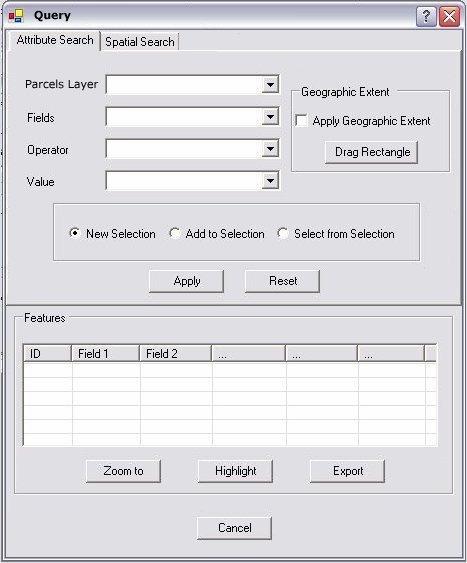
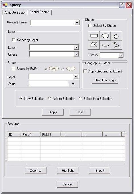
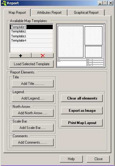
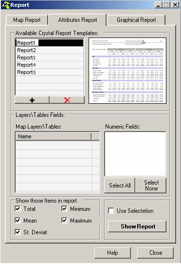
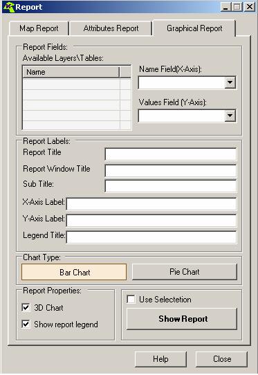
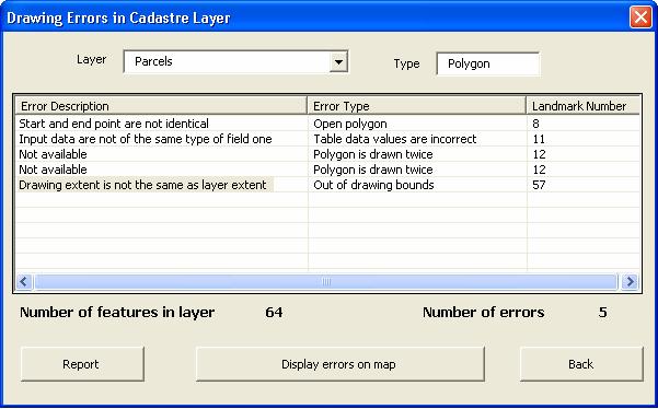
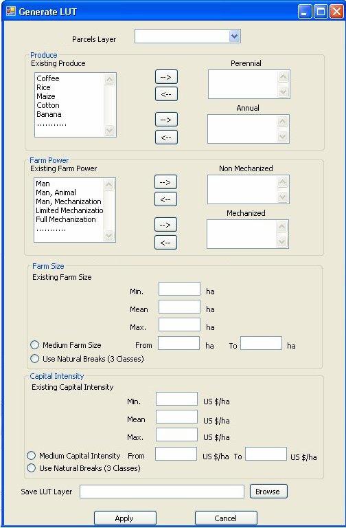
17 Interfaces NATURAL RESOURCES DEPARTMENT (NR) Spatial Attribute Search Graphical Attribute Map Report LUT Interface Quality Assurance Report Interface
18 Thank you NATURAL RESOURCES DEPARTMENT (NR)
Egyptian Nationwide Title Cadastre System
 Kholoud SAAD, Egypt Key words: Cadastre, Registration, Urban, Rural, National Cadastre, Automation, reengineering. SUMMARY With growing need for integrated information, Enterprise Solutions has become
GOVERNMENT. Case Study Ville de Trois Rivières streamlines property assessment
 GOVERNMENT Case Study Ville de Trois Rivières streamlines property assessment GIS-generated parcel basemap provides powerful visualization & analysis capabilities With a population of just over 130,000,
Using ArcGIS Server for National Property Information System
 Using ArcGIS Server for National Property Information System Shota Chachkhunashvili (National Agency of Public Registry, Georgia) Mikheil Tsiklauri (Geographic, Georgia) San Diego, 2008 About us National
LADM-based Crowdsourced 3D Cadastral Surveying Potential and Perspectives
 National Technical University Of Athens School of Rural and Surveying Engineering LADM-based Crowdsourced 3D Cadastral Surveying Potential and Perspectives Maria Gkeli, Surveying Engineer, PhD student
ArcCadastre Implementations within the Middle East
 ArcCadastre Implementations within the Middle East Kholoud Saad SALAMA, Egypt Key words: Cadastre, GIS, Survey, Data Conversion, Workflow SUMMARY In recent years, cadastre systems have developed from manual
A CADASTRAL GEODATA BASE FOR LAND ADMINISTRATION USING ARCGIS CADASTRAL FABRIC MODEL A CASE STUDY OF UWANI ENUGU, ENUGU STATE, NIGERIA
 A CADASTRAL GEODATA BASE FOR LAND ADMINISTRATION USING ARCGIS CADASTRAL FABRIC MODEL A CASE STUDY OF UWANI ENUGU, ENUGU STATE, NIGERIA BY Ndukwu, Raphael. Ike Department of Geoinformatics & Surveying University
A Complete, Free Solution for Cadastral Map Management
 A Complete, Free Solution for Cadastral Map Management Gyula IVÁN Institute of Geodesy, Cartography & Remote Sensing (FÖMI) HUNGARY FIG Commission 7, Annual Meeting 11-15 September 2008., Verona, ITALY
Cadastral Information System of Sofia
 Alexander LAZAROV and Hristo DECHEV, Bulgaria Key words: ABSTRACT A new Cadastre and Property Register Act (CPRA) was passed in April 2000, setting up rules for the maintenance of these two registers.
Cloud GIS Real Estate Management, Appraisal and Development Service USING ESRIs ARCGIS SERVER
 Cloud GIS Real Estate Management, Appraisal and Development Service USING ESRIs ARCGIS SERVER INFODIM: Was founded on 1992 and is internationally certified as a GIS company from D&B Dun & Bradstreet Global
APPLICATION OF GEOGRAPHIC INFORMATION SYSTEM IN PROPERTY VALUATION. University of Nairobi
 APPLICATION OF GEOGRAPHIC INFORMATION SYSTEM IN PROPERTY VALUATION Thesis Presented by STEPHEN WAKABA GATHERU F56/69748/2013 Supervised by DR. DAVID NYIKA School of Engineering Department of Geospatial
University of Nairobi LAND INFORMATION SYSTEM FOR LAND MANAGEMENT IN KENYA. CASE STUDY: NAIROBI COUNTY, BURUBURU PHASE I ESTATE
 University of Nairobi LAND INFORMATION SYSTEM FOR LAND MANAGEMENT IN KENYA. CASE STUDY: NAIROBI COUNTY, BURUBURU PHASE I ESTATE BY Justus Amdavi F56/69371/2013 Supervisor: Mr Jasper Mwenda CONTENTS Introduction
Massive Collection of Cadastral Data in Greece Using Web-enabled GIS Technologies
 Massive Collection of Cadastral Data in Greece Using Web-enabled GIS Technologies Lefteris LYKOUROPOULOS and George MOURAFETIS, Greece Key words: Cadastre, Web services, applications, GIS, data collection
Property Based Land Information Systems of Turkey
 Property Based Land Information Systems of Turkey Mehmet Fatih DİRİ, Bilgehan ÖZSOY, Ünsal ERGÜN, Turkey Key words: Cadaster, Land Registry, GIS, Property, TURKEY SUMMARY The property, addition to the
Object Oriented Unified Real Estate Registry for a Good Spatial Data Management
 Object Oriented Unified Real Estate Registry for a Good Spatial Data Management Gyula IVÁN Gábor SZABÓ Zoltán WENINGER Institute of Geodesy, Cartography and Remote Sensing (FÖMI), Hungary Workshop on e-governance,
 Apostolos Arvanitis, Associate Professor Asterios Asteriadis, Rural - Surveying Engineer Thomai Sotireli, Rural - Surveying Engineer Aristotle University School of Rular and Surveying Engineering Department
New Technology for Cadastral Systems. Brent Jones, PE, PLS
 New Technology for Cadastral Systems Brent Jones, PE, PLS Benefits of Good Land Administration Key to addressing global challenges.. Secure Tenure Equitable Land and Property Taxation Support for Government
Universal Geo-database Connector Interface Component (UG-CIC) For Virtual Web-base GIS Server Essential For Real Estate Industry Uses
 For Virtual Web-base GIS Server Essential For Real Estate Industry Uses") Universal Geo-database Connector Interface Component (UG-CIC) For Virtual Web-base GIS Server Essential For Real Estate Industry Uses Jad Jarroush & Dr. Kobi Zaid Zaid Orniv Group L.T.D Israel kobi_z@zaidorniv.co.il
Universal Geo-database Connector Interface Component (UG-CIC) For Virtual Web-base GIS Server Essential For Real Estate Industry Uses Jad Jarroush & Dr. Kobi Zaid Zaid Orniv Group L.T.D Israel kobi_z@zaidorniv.co.il
Designing for transparency and participation in the Hellenic Cadastral Project
 Designing for transparency and participation in the Hellenic Cadastral Project Dr. Dimitris Rokos Director of Planning and Investments, Hellenic National Cadastre and Mapping Agency S.A. Table of Contents
aurelis Real Estate GmbH & Co. KG
 www.aurelis-real-estate.com aurelis Real Estate GmbH & Co. KG IBB GIS the information platform for real-estate related data AED-SYNERGIS has implemented a pilot project for the Region South of the real-estate
Intangible Assets Web Site Costs
 SIC Interpretation 32 Intangible Assets Web Site Costs In March 2002 the International Accounting Standards Board issued SIC-32 Intangible Assets Web Site Costs, which had originally been developed by
PROCESSES IN CADASTRE: PROCESS MODEL FOR SERBIAN 3D CADASTRE
 UNIVERSITY IN NOVI SAD, SERBIA FACULTY OF TECHNICAL SCIENCES PROCESSES IN CADASTRE: PROCESS MODEL FOR SERBIAN 3D CADASTRE Dubravka SLADIĆ, Aleksandra RADULOVIĆ and Miro GOVEDARICA 6th International FIG
GAUSSCAD A WEBGIS APPLICATION FOR COLLECTING CADASTRAL DATA
 M.M. Moise GaussCAD a WebGIS Application for Collecting Cadastral Data GAUSSCAD A WEBGIS APPLICATION FOR COLLECTING CADASTRAL DATA Mihai-Mircea MOISE, S.C. GAUSS S.R.L., mihai.moise@gauss.ro Abstract:
Analyses of the Results of Land Consolidation Studies by GIS
 Analyses of the Results of Land Consolidation Studies by GIS Fatih ISCAN, Turkey Key words: Land consolidation, GIS, landholding, planning, spatial analyse SUMMARY Rural development generally refers to
The Challenge to Implement International Cadastral Models Case Finland 1
 The Challenge to Implement International Cadastral Models Case Finland 1 Tarja MYLLYMÄKI and Tarja PYKÄLÄ, Finland Key words: cadastre, modelling, LADM, INSPIRE SUMMARY Efforts are currently made to develop
Who we are? MIS GIS. Cadastral Data Management System in Turkey. View from MIS. View from GIS. Dr. Emin Bank MIS? GIS? IT?
 Cadastral Data Management System in Turkey Dr. Emin Bank ebank@islem.com.tr Who we are?? View from? Or? View from Nowadays and are getting closer fastly 1 Viewing from is changing Viewing from is changing
11 Teranet Easement Mapping Data Acquisition
 Clause 11 in Report No. 18 of Committee of the Whole was adopted, without amendment, by the Council of The Regional Municipality of York at its meeting held on November 19, 2015. 11 Teranet Easement Mapping
Land Information System for Revenue Planning, Estimates and Collection
 Land Information System for Revenue Planning, Estimates and Collection Hardi FADILLAH HAMZAH, Malaysia Key words: valuation, land revenues SUMMARY With the emerging trend of State Government implementing
PREPARING SURVEY TENDER GIS DATABASE OUTCOMES
 PREPARING SURVEY TENDER SPECIFICATIONS FOR PROJECT GIS DATABASE OUTCOMES Presentation by Ian Harper GEODATA AUSTRALIA ESRI User Conference 2009 24 st July 2009 BACKGROUND GIS databases now provide a more
Fit-for Purpose Approaches to Land Administration
 Fit-for Purpose Approaches to Land Administration Brent Jones, PE, PLS Global Manager, Casastre/Land Records bjones@esri.com Land Administration GIS is the platform for land administration Land administration
Hungarian Cadastre and its relation to LADM
 Hungarian Cadastre and its relation to LADM Gyula IVÁN CLGE General Assembly 22 March 2013, Budapest, HUNGARY Content Historical background Evolution of Cadastral modeling in Hungary LADM issues Conclusion
Test and Implementation of DATR System in Hungary
 Test and Implementation of DATR System in Hungary, Hungary Key words: unified land registry, cadastral map, Hungary SUMMARY During the last years there has been an important development in the Hungarian
A NOMINAL ASSET VALUE-BASED APPROACH FOR LAND READJUSTMENT AND ITS IMPLEMENTATION USING GEOGRAPHICAL INFORMATION SYSTEMS
 A NOMINAL ASSET VALUE-BASED APPROACH FOR LAND READJUSTMENT AND ITS IMPLEMENTATION USING GEOGRAPHICAL INFORMATION SYSTEMS by Tahsin YOMRALIOGLU B.Sc., M.Sc. A thesis submitted for the Degree of Doctor of
REGISTRATION OF PROPERTIES IN STRATA
 REGISTRATION OF PROPERTIES IN STRATA REPORT ON THE WORKING SESSIONS INTRODUCTION A cadastre is usually, and in most countries, a parcel-based, and up-to-date land information system containing records
REFORM OF LAND CADASTRE IN LITHUANIA
 REFORM OF LAND CADASTRE IN LITHUANIA Romualdas KASPERAVICIUS, Lithuania Key words: ABSTRACT Main aim for every Government is to create legal, financial and organisational circumstances for real property.
FGDC Cadastral Data Subcommittee. December 2008
 FGDC Cadastral Data Subcommittee Annotated Bibliography: Foundational Documents for Building a Cadastral National Prepared by David Stage and Nancy von Meyer for the FGDC Cadastral Data Subcommittee Annotated
NEW DEVELOPMENTS IN THE REAL PROPERTY REGISTER AND CADASTRE IN LITHUANIA
 NEW DEVELOPMENTS IN THE REAL PROPERTY REGISTER AND CADASTRE IN LITHUANIA Jaunius Grigas E-mail: jaunius.grigas@registrucentras.lt Verona, 2008 FUNCTIONS OF STATE ENTERPRISE CENTRE OF REGISTERS Registration
The New Technology of a Survey Data Model and Cadastral Fabric as the Foundation for a Future Land Administration System.
 The New Technology of a Survey Data Model and Cadastral Fabric as the Foundation for a Future Land Ian HARPER, Australia Key words: cadastral modelling, survey data model, Survey Accuracy, Cadastre 2014
City of Surrey s Digital Plan Submission Process
 City of Surrey s Digital Plan Submission Process Cadastral Update Karen Stewart, B.Tech. (GIS) Spatial Information Manager Peter Mueller, B.C.L.S., C.L.S. Survey Manager City of Surrey, British Columbia,
A Vision for a Fully Digital Cadastral Survey System
 A Vision for a Fully Digital Cadastral Survey System Anselm HAANEN, Trent GULLIVER, New Zealand Key words: cadastral survey system, digital cadastre, survey plans SUMMARY Surveyors have traditionally prepared
Development of 3D Cadastre in Hungary
 Development of 3D Cadastre in Hungary András OSSKÓ Gyula IVÁN CLGE General Assembly 22 March 2013, Budapest, HUNGARY Content Introduction Problems in development of 3D cadastre and registration Hungarian
Cadastral Information System for M.I. Wushishi Housing Estate.
 Cadastral Information System for M.I. Wushishi Housing Estate. Kemiki O. A 1 * Odumosu J.O 2 Ayoola A.B 1 Popoola N.I 1 1, Department of Estate Management and Valuation, Federal University of Technology,
Country report, HUNGARY
 Country report, HUNGARY Gyula IVÁN Institute of Geodesy, Cartography & Remote Sensing (FÖMI) HUNGARY FIG Commission 7 Annual Meeting 2009 12-16 October, 2009, Kuala Lumpur, Malaysia Institute of Geodesy,
Unified Land Administration for a Better Spatial Infrastructure
 Unified Land Administration for a Better Spatial Infrastructure Gyula IVÁN Institute of Geodesy, Cartography & Remote Sensing FÖMI (HUNGARY) Open Symposium 30th Korean Cadastral Seminar & FIG Commission
INTRODUCTION - Land is the platform of all societies activities. - Land policy regulates the access to land and the management of land.
 INTRODUCTION - Land is the platform of all societies activities. - Land policy regulates the access to land and the management of land. - An acceptable and proactive land policy is a critical success factor
Estonian e-cadastre as basis for efficient land management
 Estonian e-cadastre as basis for efficient land management Priit Kuus Estonian Land Board November 14, 2017 Tallinn Scope of data Cadastral parcels (as of October 2017) 693 026 cadastral parcels, i.e.
Land Details. Bridging the Gap between Assessor Acres and GIS Acres
 Land Details Bridging the Gap between Assessor Acres and GIS Acres What are Assessor Acres? It is a legally agreed upon approximation of size Applies to larger parcels Has deep historical roots. Thomas
Quality Improvement of the Real Estate Cadastre in Serbia
 , Serbia Key words: quality improvement, real estate information, quality assurance, Serbia SUMMARY The concept of cadastral modernization in the Republic of Serbia was defined in 1992, and it is being
Cube Land integration between land use and transportation
 Cube Land integration between land use and transportation T. Vorraa Director of International Operations, Citilabs Ltd., London, United Kingdom Abstract Cube Land is a member of the Cube transportation
A Geocoded Cadastral Fabric as a Precondition for a Sustainable Land Management System
 A Geocoded Fabric as a Precondition for a Sustainable Land Management System Gottfried KONECNY, Germany; J.P. LAUZON, Canada; Abdul Salam MOHAMMED, India Key words: SDI,, Parcel Boundaries, GPS-GNSS, Land
SANDAKAN PUBLIC HALL MANAGEMENT SYSTEM GRACE YAIT LINGGOU FACULTY OF COMPUTING AND INFORMATICS UNIVERSITI MALAYSIA SABAH
 SANDAKAN PUBLIC HALL MANAGEMENT SYSTEM GRACE YAIT LINGGOU FACULTY OF COMPUTING AND INFORMATICS UNIVERSITI MALAYSIA SABAH 2015 ABSTRACT Sandakan Public Hall Management System was a web-based reservation
Configuring Service Charge Settlement in Flexible Real Estate Management (RE FX)
") Configuring Service Charge Settlement in Flexible Real Estate Management (RE FX) Applies to: Any consultant who wants to configure the Service Charge Settlement settings for user requirements in SAP flexible
Configuring Service Charge Settlement in Flexible Real Estate Management (RE FX) Applies to: Any consultant who wants to configure the Service Charge Settlement settings for user requirements in SAP flexible
BULGARIAN CADASTRE A GUARANTEE FOR THE OWNERSHIP RIGHTS IN IMMOVABLE PROPERTIES
 4 TH INTERNATIONAL CONFERENCE RECENT PROBLEMS IN GEODESY AND RELATED FIELDS WITH INTERNATIONAL IMPORTANCE February 28 - March 2, 2007, Inter Expo Centre, Sofia, Bulgaria BULGARIAN CADASTRE A GUARANTEE
Directorate of Survey and Mapping NAMIBIA. Cadastral Information System. Vehupisa Kasuko Tjatindi Surveyor Directorate of Survey and Mapping NAMIBIA
 Vehupisa Kasuko Tjatindi Directorate of Survey and Mapping NAMIBIA Tel: +64 61 965000 Directorate of Survey and Mapping NAMIBIA Cadastral Information System Introduction Over the past few decades cadastral
LIS a motivation for SDI initiative
 Eric Mwaikambo Ardhi University Dar es Salaam Tanzania Overview Status of LIS in Tanzania Relationship between SDI and LIS Spatial Standards LIS a motivation for SDI initiative Conclusion & Recommendations
TOWARDS E-LAND ADMINISTRATION - ELECTRONIC PLANS OF SUBDIVISIONS IN VICTORIA
 TOWARDS E-LAND ADMINISTRATION - ELECTRONIC PLANS OF SUBDIVISIONS IN VICTORIA Mohsen Kalantari 1, Chris Lester 2, David R Boyle 3, Neil Coupar 4 1 eplan Coordinator 2 SPEAR Manager 3 Deputy Surveyor General
Registering Property
 Registering Property Delhi 1. Description of Reform: For procedure 3 Conduct charges search at the Registrar of Companies, Doing Business 2018 records that the buyer must conduct a search in office of
Cadastral services and virtual office in e-cadastre
 Cadastral services and virtual office in e-cadastre Priit Kuus Estonian Land Board October 26, 2016 Coimbra Scope of data Cadastral parcels (as of September 2016) 674 383 cadastral parcels, i.e. 97,7 %
Modernizing Land Administration Systems
 Presented at the FIG Congress 2018, May 6-11, 2018 in Istanbul, Turkey Modernizing Land Administration Systems B r e n t J o n e s P E, PLS E s r i Land Administration Systems GIS is the Technology Platform
Challenge to Implement International Cadastral Models Case Finland
 FIG Articleof the Month April 20 Challenge to Implement International Cadastral Models Case Finland Tarja Myllymäki and Tarja Pykälä 200-04-5 The topics are In European level INSPIRE Experiences, similarities,
Ministry of Mines, Industry and SME
 Republic of Senegal Ministry of Mines, Industry and SME User Conference 2010 08/02/2010 COPYRIGHT 2010. SPATIAL DIMENSION (PTY) LTD. A MINING CADASTRE IN SENEGAL: IMPLEMENTATION PROCESS AND ORGANIZATIONAL
IT-SUPPORTED STATE-LAND MANAGEMENT IN A TRANSITIONAL ENVIRONMENT
 IT-SUPPORTED STATE-LAND MANAGEMENT IN A TRANSITIONAL ENVIRONMENT - Examples from Eastern Germany and Mongolia - TOPICS 1 S LAND INFORMATION SYSTEM History and main components IT-strategy and development
The Contribution of Forest Owners Associations for the Forest Cadastre Implementation. João Gaspar Ana Navarro Ferreira PORTUGAL
 The Contribution of Forest Owners Associations for the Forest Cadastre Implementation João Gaspar Ana Navarro Ferreira PORTUGAL Motivation Lack of forestry cadastre; Unify all FOAs databases with common
Preprint.
 http://www.diva-portal.org Preprint This is the submitted version of a paper presented at 10th EC GI & GIS Workshop, ESDI State of the Art, Warsaw, Poland, 23-25 June 2004. Citation for the original published
Installation Boundary Mapping and the DoD Real Property Inventory Program
 Installation Boundary Mapping and the DoD Real Property Inventory Program 11 October 2007 SAME Mid-Atlantic Regional Conference Jeff Swallow Real Property History Real Property data reported to the Office
Using GIS To Manage Surface Ownership and Right-Of-Way
 Using GIS To Manage Surface Ownership and Right-Of-Way Jeff Bute - Sr. Land Maintenance Rep. / GIS Analyst Jeff was formerly a Property Tax Right of Way and Claims field agent for the company. Now he uses
Integrating SAS and Geographic Information Systems for Regional Land Use Planning
 Integrating SAS and Geographic Information Systems for Regional Land Use Planning ABSTRACT Bill Bass, Houston-Galveston Area Council, Houston, Tx The Houston-Galveston Area Council (H-GAC) provides regional
Georgia Department of Revenue. WinGAP. Georgia CAMA Software
 WinGAP Georgia CAMA Software Presenter Tracy Thomas Business Operations Specialist Georgia Department of Revenue Local Government Services tracy.thomas@dor.ga.gov Public Utility Appraisal Eight DOR field
Esri Middle East and Africa User Conference. December Abu Dhabi, UAE. Land Administration. Mark Baker
 Esri Middle East and Africa User Conference December 10 12 Abu Dhabi, UAE Land Administration Mark Baker Our Agenda 0900 0930 Welcome Mark Baker, Esri 0930 1030 New Directions The New Addressing System
ACCOUNTING STANDARDS BOARD INTERPRETATION OF THE STANDARDS OF GENERALLY RECOGNISED ACCOUNTING PRACTICE
 ACCOUNTING STANDARDS BOARD INTERPRETATION OF THE STANDARDS OF GENERALLY RECOGNISED ACCOUNTING PRACTICE INTANGIBLE ASSETS WEBSITE COSTS (IGRAP 16) Issued by the Accounting Standards Board March 2012 Acknowledgment
Advances in Modern Land Administration Cadastre 2014 in the Year 2006
 Advances in Modern Land Administration Cadastre 2014 in the Year 2006 Winfried HAWERK, Germany Key words: E-Land Administration, IT renewal strategies SUMMARY FIG Commission 7 Working Group 7.3 deals with
Bureau of Land Management
 Bureau of Land Management MAPPS Federal Update Donald Buhler Cadastral, Lands, and Realty Management April 1, 2014 Division of Cadastral, Lands and Realty Management 1 BLM Mission Manages 247 million surface
SECTOR PUBLIC CADASTRES AND REGISTERS MARKET PARTICIPANTS
 E-SERVICES TO CITIZENS, GOVERNMENT AND BUSINESSES. LITHUANIA EXPERIENCE Arvydas Bagdonavičius State Enterprise Centre of Registers Arvydas.Bagdonavicius@registrucentras.lt REGISTERS AND IS MANAGED BY THE
Contents. & equitable. 16 Cover illustration by Chris Bennett and Daniel Anzaldi, RES FAIR. 3 Appraiser-Friendly GIS: Cover Story
 Contents AUGUST 2006 VOLUME 4. NUMBER 8 Cover Story 3 Appraiser-Friendly GIS: Keeping the Focus on the User by Daniel Anzaldi, RES Feature Article 7 A Partnership in Integration: The State of Wyoming and
TSO1C: Land Reforms. Commission 7
 TSO1C: Land Reforms. Commission 7 Development of & Implementation LIS. Building an effective Partnership to Reform Uganda s Land Administration (7320) Gasant Jacobs, Head: Business Development. Tax & Accounting
PROJECT INFORMATION DOCUMENT (PID) CONCEPT STAGE Report No.: AB3229 Project Name. Land Registry and Cadastre Modernization Project Region
 CONCEPT STAGE Report No.: AB3229 Project Name. Land Registry and Cadastre Modernization Project Region") PROJECT INFORMATION DOCUMENT (PID) CONCEPT STAGE Report No.: AB3229 Project Name Land Registry and Cadastre Modernization Project Region EUROPE AND CENTRAL ASIA Sector Central government administration
PROJECT INFORMATION DOCUMENT (PID) CONCEPT STAGE Report No.: AB3229 Project Name Land Registry and Cadastre Modernization Project Region EUROPE AND CENTRAL ASIA Sector Central government administration
Glenn Matthews Director: Business Development Natural Resources. Landfolio - Competitor Monitoring Solutions
 Glenn Matthews Director: Business Development Natural Resources Landfolio - Competitor Monitoring Solutions Tracking Competitors WHY KEEP TRACK OF YOUR COMPETITORS TENURE HOLDING Expose Competitive Opportunities
What s Next for Commercial Real Estate Leveraging Technology and Local Analytics to Grow Your Commercial Real Estate Business
 What s Next for Commercial Real Estate Leveraging Technology and Local Analytics to Grow Your Commercial Real Estate Business - A PUBLICATION OF GROWTH MAPS- TABLE OF CONTENTS Intro 1 2 What Does Local
PROPERTY ASSESSMENT KNOWLEDGE
 A P E N DE UM NOUN A COLLECTION OF CONCISE BUT DETAILED INFORMATION ABOUT APPRAISAL AND APPRAISAL MANAGEMENT, ESPECIALLY IN THE PROPERTY ASSESSMENT INDUSTRY. PROPERTY ASSESSMENT KNOWLEDGE KNOWLEDGE AREAS
Case Study - Management of Geospatial Cadastral Data Using Dedicated Products
 Case Study - Management of Geospatial Cadastral Data Using Dedicated Products ANA-CORNELIA BADEA Surveying and Cadastre Department Technical University of Civil Engineering Bucharest, Faculty of Geodesy
SLRB Bahrain 3D Property Registration System
 Rashid Kashram AMMAR and Dixit NEERAJ, Bahrain Key words: Property Registration, 'Parcel in Air, 3D, Case File Application System, Technical Affairs Directorate, SLRB Bahrain SUMMARY Technical Affairs
Office of the County Auditor. Broward County Property Appraiser Report on Transition Review Services
 Office of the County Auditor Broward County Property Appraiser Report on Transition Review Services January 14, 2005 Table of Contents BACKGROUND AND SCOPE...3 FINDINGS AND RECOMMENDATIONS...3 1. Financial
Participants of the Ministerial Meeting on Housing and Land Management on 8 October 2013 in Geneva
 Summary At its meeting on 2 April 2012, the Bureau of the Committee on Housing and Land Management of the United Nations Economic Commission for Europe agreed on the need for a Strategy for Sustainable
Introduction of a Land Registry service delivery company
 Introduction of a Land Registry service delivery company Response by the Council of Mortgage Lenders to the Department for Business, Innovation and Skills Introduction 1. The CML is the representative
Land Registry. Issues in current system
 Land Registry The land is one of the most controversial subjects in India. It lacks proper system to maintain land records and provide a person with conclusive titles results from infrequent and long drawn
Real Estate Transaction Method And System
 ( 1 of 1 ) United States Patent Application 20060282378 Kind Code A1 Gotfried; Bradley L. December 14, 2006 Real Estate Transaction Method And System Abstract A method and system for brokering real estate
The creation of a Survey Accurate Cadastral Map for surveyed areas in Trinidad & Tobago
 The creation of a Survey Accurate Cadastral Map for surveyed areas in Trinidad & Tobago Anesh Gopee, Keith Miller and Charisse Griffith Charles University of the West Indies Trinidad aneshtt@yahoo.com
Support to Implementation of Multipurpose Cadastral Information system in Vietnam
 Support to Implementation of Multipurpose Cadastral Information system in Vietnam Lennart JOHANSSON and Per SÖRBOM, Sweden Key words: Land Registration, Land Information, Land Administration, SWOT analyse,
FGDC SUBCOMMITTEE FOR CADASTRAL DATA. October 2004 Albuquerque, New Mexico Meeting
 FGDC SUBCOMMITTEE FOR CADASTRAL DATA October 2004 Albuquerque, New Mexico Meeting The National Spatial Data Infrastructure is the means to assemble geographic information that describes the arrangements
Revenue. Major part of ULB's revenue comes by means of:
 Revenue Major part of ULB's revenue comes by means of: Collecting property tax Issuing trade licenses Alloting its land and buildings to carry out business Collecting usage charges and service fees for
New Developments in the Hellenic Cadastre
 New Developments in the Hellenic Cadastre Prof. M. Kavouras Vice-president Ktimatologio S.A. (Hellenic Cadastre) The Hellenic Cadastre Background The Hellenic National Cadastre Organizational and institutional
COMPUTERIZED SYSTEM SUPPORTING DEVELOPMENT OF LAND MARKET IN GEORGIA
 COMPUTERIZED SYSTEM SUPPORTING DEVELOPMENT OF LAND MARKET IN GEORGIA S. G. TSIRAMUA, I. S. MELASHVILI Land Registration Unit of Government of Georgian, World Bank and IFAD Agriculture Development Project.
From 2D representation of the buildings into cadastral maps towards 3D GIS applications and BIM a case study for Prishtina
 From 2D representation of the buildings into cadastral maps towards 3D GIS applications and BIM a case study for Prishtina This is a Peer Reviewed Paper Fisnik LOSHI, Kosovo Keywords: 3D cadastre, property
DEVELOPMENT OF A STUDY OF IMPLEMENTATION OF THE CADASTRE OF BUILDINGS IN THE REPUBLIC OF CROATIA
 REPUBLIC OF CROATIA Ministry of Construction and Physical Planning State Geodetic Administration Gruška 20, 10000 ZAGREB, CROATIA Phone: +385-1-6165-404 Fax: +385-1-6165-484 Terms of Reference DEVELOPMENT
EduMapping + JobMapping
 EduMapping + JobMapping Frans Rip Centre for Geoinformation, Wageningen UR 18 April 2011 1. What is EduMapping? Present GI-course descriptions Toekomst: mèt etiket Assessment by teacher Course content
Cadastral Re-Alignment: Water Corporation approach to spatial data shifting
 Cadastral Re-Alignment: Water Corporation approach to spatial data shifting David Bulfield, Team Leader Spatial Systems Team, Spatial Information Management, Water Corporation (Western Australia) Justin
Features Guide. Enhancements. Mortgage Calculators VERSION 7. May 2008
 Features Guide VERSION 7 May 2008 Copyright 2002-2008 SuperTech Software All rights reserved. Printed in Australia. Enhancements This document describes new features and enhancements in POSH. Mortgage
GIS and Land Records Integration A PRIA White Paper
 110 Horizon Drive, Suite 210, Raleigh, NC 27615 919.459.2081 GIS and Land Records Integration A PRIA White Paper Adopted by the PRIA Board on December 20, 2017 www.pria.us/ GIS and Land Records Integration
Ohio Department of Transportation. Division of Engineering. Office of Real Estate. Synergy. Real Estate Business Analysis
 Ohio Department of Transportation Division of Engineering Office of Real Estate Synergy Real Estate Business Analysis Relocation System Specification Version 1.00 Revision History Date Version Modified
ParcelMap BC. Compiling a Parcel Fabric for the Province of British Columbia. WENDY AMY and ELLEN STYNER
 ParcelMap BC Compiling a Parcel Fabric for the Province of British Columbia WENDY AMY and ELLEN STYNER Who is MNC? Established in 1997, MNC is a geomatics engineering firm located in Calgary, Alberta.
Field surveying inspection using tablets
 Field surveying inspection using tablets Rami Farraj, Ahmad Sghyyer Survey of Israel, Lincoln 1, Tel-Aviv, Israel rami@mapi.gov.il ahmad@mapi.gov.il Key words: Field Surveying, Cadastre, Mapping Procedures