The GIS Behind Dakota County s FARMLAND AND NATURAL AREAS PROGRAM
|
|
|
- Georgiana Gardner
- 6 years ago
- Views:
Transcription
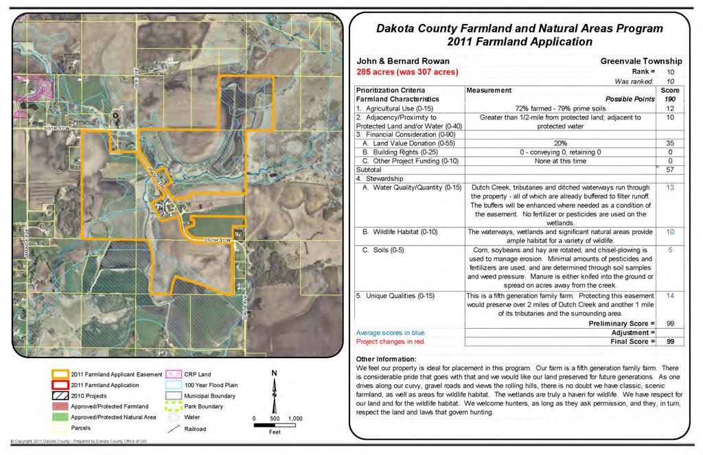
1 The GIS Behind Dakota County s FARMLAND AND NATURAL AREAS PROGRAM The Farmland and Natural Areas Program is a voluntary program in which Dakota County and other partners work with willing landowners to protect agricultural land and natural resources through conservation easements. The overall goal of the program is to protect agricultural areas while improving water quality and wildlife habitats and to protect, connect and manage natural areas.

2 The GIS Behind Dakota County s FARMLAND AND NATURAL AREAS PROGRAM To date, 2,651 acres of natural areas and 5,312 acres of farmland have been permanently protected under the program, worth an estimated $75 million. The Office of GIS and SWCD work cooperatively to develop GIS databases, layers, maps, and information critical to the implementation and success of this program.
3 The GIS Behind Dakota County s FARMLAND AND NATURAL AREAS PROGRAM GIS Components Agricultural Market Accessibility Easement Scoring Process Maps Scoring Assessments Data & Reporting
 Natural Area Maps Stewardship Plan Maps Project Summary Maps Exhibit A-1 Maps Property")
4 The GIS Behind Dakota County s FARMLAND AND NATURAL AREAS PROGRAM A Working Partnership Office of GIS Draft Easement Maps Scoring Criteria Maps SWCD Field Maps Land Cover Maps Soil Maps (Eligibility Indicator: 80% Prime Soils) Natural Area Maps Stewardship Plan Maps Project Summary Maps Exhibit A-1 Maps Property Report
5 The GIS Behind Dakota County s FARMLAND AND NATURAL AREAS PROGRAM Prioritization of Easement Applications Agricultural Market Accessibility Farmland Scoring Process Natural Area Scoring Process Staff Time/Funding
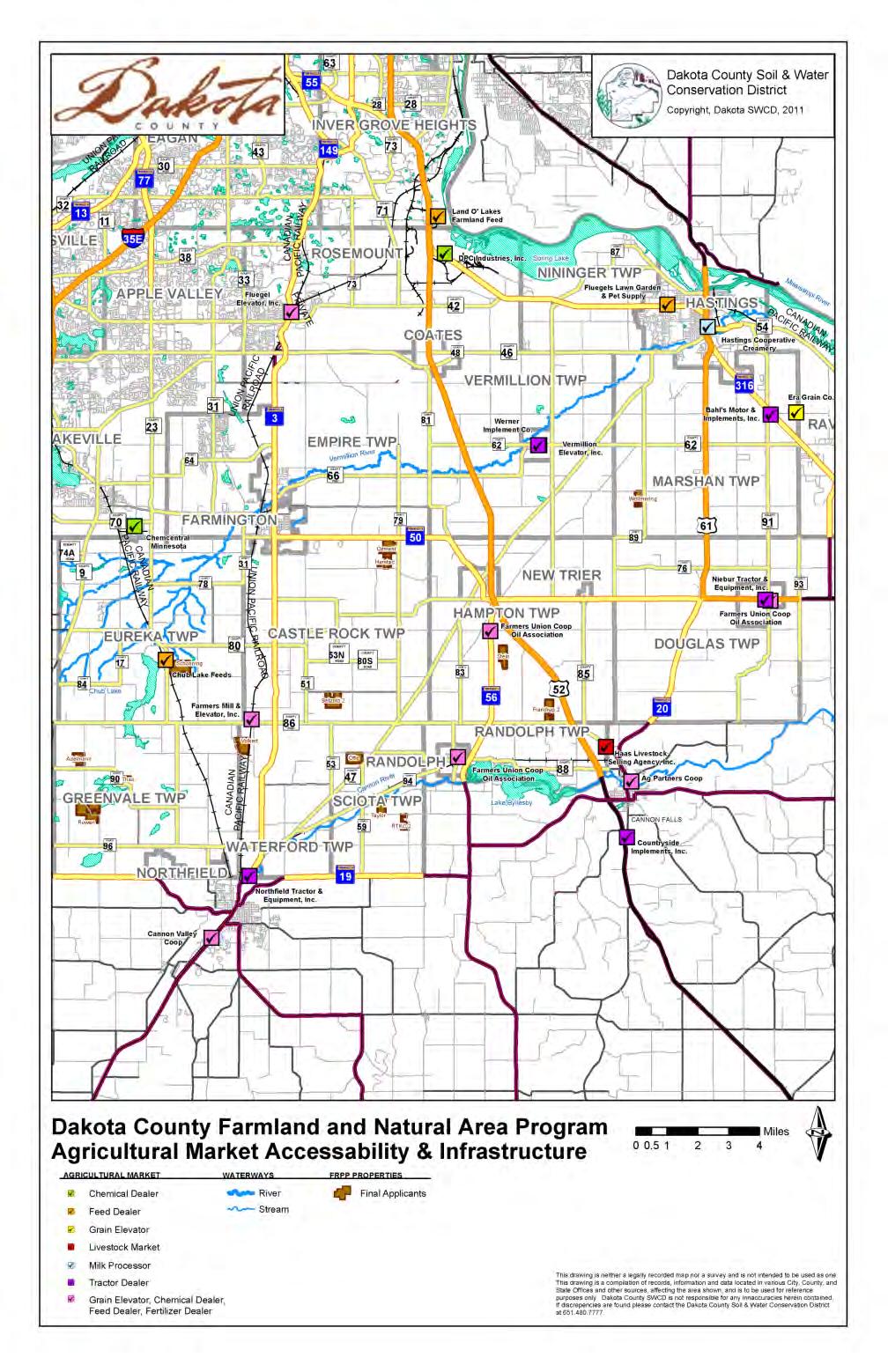
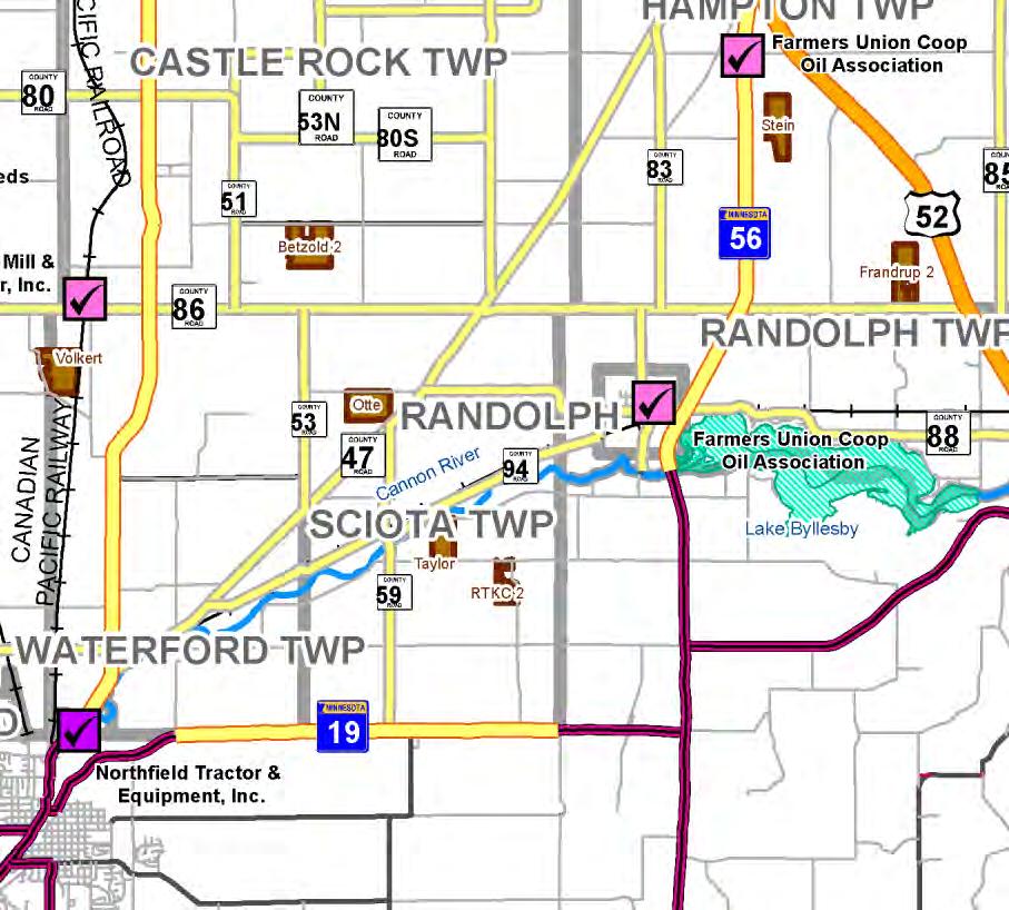
6 Agricultural Market Accessibility Map
7 The GIS Behind Dakota County s FARMLAND AND NATURAL AREAS PROGRAM Farmland Scoring Process Location 230 points A. Water Adjacency 0 to 70 B. Agricultural Conservation Zone 0 to 60 C. Natural Area Conservation Zone 0 to 50 D. Open Space Corridor (660 ft. width) 0 to 40 (Vegetated buffer and no development) E. Land Adjacency 0 or 10 Note: Points are calculated based on the percentage of project acres within zones.

8 Farmland Scoring Map
9 The GIS Behind Dakota County s FARMLAND AND NATURAL AREAS PROGRAM Natural Area Scoring Process Location 215 points A. Priority Natural Area 0 to 50 B. Open Space Corridor 0 to 40 C. Natural Area Conservation Zone 0 to 40 D. Non-riparian Greenway 0 to 30 E. Water Adjacency 0 to 30 F. Urban/Suburban 0 to 15 G. Adjacency to Protected Land 0 or 10 Note: Points are calculated based on percentage of project acres within zones.

10 Natural Area Scoring Map


11 Natural Area Conservation Zones
12 The GIS Behind Dakota County s FARMLAND AND NATURAL AREAS PROGRAM Maps Property Reports Easement Map Field Areas Map Land Cover Map Natural Areas Map Prime Farmland Map Pre-settlement Vegetation Map Historical Aerial Photography Maps (1959, 1964, 1991) Stewardship Plan Map Project Summary Map Exhibit A-1 Map
13 Exhibit A-1 Map Part of Recorded Deed/Documents Created from legal description

14 Field Areas Map

15 Land Cover Map

16 Natural Areas Map

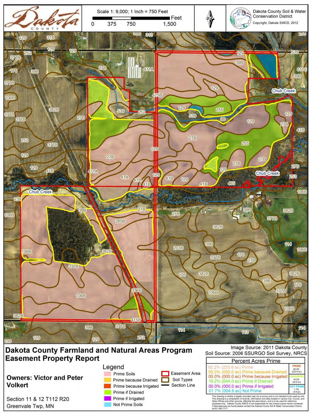

17 Prime Soils Map

18 Scoring Assessments Farmland Area Easements Delineate Field Areas Map Clip Farmland Class w Fields Summarize Farmland Class by Prime Soils Model to Automate Process

19 The GIS Behind Dakota County s FARMLAND AND NATURAL AREAS PROGRAM Soil Map Automation

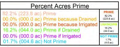
20 Scoring Assessments Farmland Area Easements Initial Prime Soils Map If below 80% Prime Soils: Check for lateral drainage effect due to Drain Tile to evaluate additional Prime Soils because drained/irrigated


21 The GIS Behind Dakota County s FARMLAND AND NATURAL AREAS PROGRAM Reporting Data Farmland Property Reports Land Cover Prime Farmland

22 75ft Native Buffer Stewardship Plan Farmland Area Easements Stewardship Plan Map Existing Wetlands 30ft Native Buffer

23 Project Summary Map
24 The GIS Behind Dakota County s FARMLAND AND NATURAL AREAS PROGRAM Acknowledgements Parks and Open Space Water Resources GIS and IT Surveyor s Office Office of Planning and Analysis Financial Services Transportation Attorney s Office Assessor s Office Communications Environmental Management Administrative Coordination Services Dakota SWCD Friends of Mississippi River MnDNR NRCS USDA Farm and Ranch Lands
25 The GIS Behind Dakota County s FARMLAND AND NATURAL AREAS PROGRAM Questions? David Holmen Resource Conservationist / Information Technology Specialist Dakota County Soil and Water Conservation District th Street West, Suite 102 Farmington, MN david.holmen@co.dakota.mn.us voice: (651) fax: (651) availability: Monday - Friday/ 7:00am - 4:30pm Central Dan Castaneda GIS Technician Dakota County Office of GIS Galaxie Ave. Apple Valley, MN dan.castaneda@co.dakota.mn.us voice: (952) fax: (952) availability: Monday - Friday/ 8:00am - 4:30pm Central
Dakota County Farmland and Natural Areas Program. Lake Pepin TMDL May 31, 2007
 Dakota County Farmland and Natural Areas Program Lake Pepin TMDL May 31, 2007 Presentation Overview County Context FNAP Planning Process FNAP Implementation Integrating Conservation Efforts Parcel Development
AGRICULTURAL CONSERVATION EASEMENT PROGRAM AGRICULTURAL LAND EASEMENTS
 AGRICULTURAL CONSERVATION EASEMENT PROGRAM AGRICULTURAL LAND EASEMENTS OVERVIEW The Agricultural Conservation Easement Program (ACEP) is a voluntary federal conservation program implemented by the USDA
Minnesota Water Quality and Habitat Conservation Reserve Enhancement Program (MN CREP) Overview February 14, 2017
 Overview February 14, 2017") Minnesota Water Quality and Habitat Conservation Reserve Enhancement Program (MN CREP) Overview February 14, 2017 1 MN Conservation Reserve Enhancement Program (MN CREP) General Overview Practices, Outcomes,
Minnesota Water Quality and Habitat Conservation Reserve Enhancement Program (MN CREP) Overview February 14, 2017 1 MN Conservation Reserve Enhancement Program (MN CREP) General Overview Practices, Outcomes,
The Maryland Rural Legacy and CREP Easement Programs
 The Maryland Rural Legacy and CREP Easement Programs The Points Based Method: The EVS Saving America s Farms and Farmland National Conference May 12, 2014 WHAT IS AN EVS? A method of awarding points to
Minnesota Board of Water and Soil Resources Wetland Conservation Act 2017 Annual Reporting Form
 Minnesota Board of Water and Soil Resources Wetland Conservation Act 2017 Annual Reporting Form Use the tab key to navigate between fields. Local Government Unit (LGU): Becker SWCD Organization Type: SWCD
2015 Reinvest in Minnesota (RIM) Reserve Wetlands Program
 Reserve Wetlands Program") 2015 Reinvest in Minnesota (RIM) Reserve Wetlands Program Eligibility Guidance Document 1/16/15 The purpose of the RIM Wetlands Program is to identify and enroll under permanent easement lands that contain
2015 Reinvest in Minnesota (RIM) Reserve Wetlands Program Eligibility Guidance Document 1/16/15 The purpose of the RIM Wetlands Program is to identify and enroll under permanent easement lands that contain
120 Acres of Jackson, NH Ski Touring Foundation Land Protected by a USDA Natural Resources Conservation Service Wetland Reserve Easement
 120 Acres of Jackson, NH Ski Touring Foundation Land Protected by a USDA Natural Resources Conservation Service Wetland Reserve Easement (Degraded Wetlands Will Also Be Restored by the USDA NRCS) The Jackson
WYOMING COUNTY PURCHASE OF DEVELOPMENT RIGHTS (PDR) PROGRAM. NYS Farmland Protection Implementation Grants (FPIG) PRE-APPLICATION
 PROGRAM. NYS Farmland Protection Implementation Grants (FPIG) PRE-APPLICATION") WYOMING COUNTY PURCHASE OF DEVELOPMENT RIGHTS (PDR) 2019-2020 PROGRAM NYS Farmland Protection Implementation Grants (FPIG) PRE-APPLICATION Applicant (Farm) Name: Total Acres included in this pre-application
WYOMING COUNTY PURCHASE OF DEVELOPMENT RIGHTS (PDR) 2019-2020 PROGRAM NYS Farmland Protection Implementation Grants (FPIG) PRE-APPLICATION Applicant (Farm) Name: Total Acres included in this pre-application
LAKE OF THE WOODS COUNTY WETLAND CONSERVATION ORDINANCE OF 2002
 Ordinance # LAKE OF THE WOODS COUNTY WETLAND CONSERVATION ORDINANCE OF 2002 ARTICLE 1 TITLE AND PURPOSE Section 1.1. Title This Ordinance shall be known, cited and referred to as the Lake of the Woods
Claudia Stuart, Williamson Act Program Manager and Nick Hernandez, Planning Intern
 Land Conservation (Williamson) Act Advisory Committee STAFF REPORT September 15, 2014 Prepared by: Claudia Stuart, Williamson Act Program Manager and Nick Hernandez, Planning Intern Subject: Discussion:
Conservation Design Subdivisions
 Conservation Design Subdivisions An excerpt from the Rules and Regulations Governing Division of Land in Sheridan County, Wyoming, November 5, 2010 Sheridan County Public Works Department 224 S. Main Street
Kent/MSU Extension Attn: Stacy Byers 775 Ball Ave NE Grand Rapids, MI Tel: (616)
") 2017 KENT COUNTY PURCHASE OF DEVELOPMENT RIGHTS (PDR) PROGRAM Kent/MSU Extension Attn: Stacy Byers 775 Ball Ave NE Grand Rapids, MI 49503 Email: stacy@sheridanland.com Tel: (616) 632-7878 FOR OFFICIAL
2017 KENT COUNTY PURCHASE OF DEVELOPMENT RIGHTS (PDR) PROGRAM Kent/MSU Extension Attn: Stacy Byers 775 Ball Ave NE Grand Rapids, MI 49503 Email: stacy@sheridanland.com Tel: (616) 632-7878 FOR OFFICIAL
Implementation of Permanent Easements and Associated Nutrient Load Reductions
 1 Minnesota Nutrient Reduction Strategy Agricultural Sector/BWSR RIM Program Measure Implementation of Permanent and Associated Nutrient Load Reductions Measure Background Visual Depiction The map in Figure
FINAL DRAFT 12/1/16, Rev. to 7/18/17
 FINAL DRAFT 12/1/16, Rev. to 7/18/17 (As Adopted 8/8/17 Effective 9/1/17) SHELTON PLANNING AND ZONING COMMISSION Proposed Amendments to Zoning Regulations I. Amend Section 23 PERMITTED USES by inserting
SUBCHAPTER 59F CONSERVATION RESERVE ENHANCEMENY ENHANCEMENT PROGRAM (CREP) STATE PORTION OF THE PROGRAM
 STATE PORTION OF THE PROGRAM") SUBCHAPTER 59F CONSERVATION RESERVE ENHANCEMENY ENHANCEMENT PROGRAM (CREP) STATE PORTION OF THE PROGRAM SECTION.0100 - CONSERVATION RESERVE ENHANCEMENT PROGRAM (CREP) -- STATE PORTION OF THE PROGRAM 02
SUBCHAPTER 59F CONSERVATION RESERVE ENHANCEMENY ENHANCEMENT PROGRAM (CREP) STATE PORTION OF THE PROGRAM SECTION.0100 - CONSERVATION RESERVE ENHANCEMENT PROGRAM (CREP) -- STATE PORTION OF THE PROGRAM 02
FARMLAND AMENITY PROTECTION. A Brief Guide To Conservation Easements
 FARMLAND AMENITY PROTECTION A Brief Guide To Conservation Easements The purpose of this guide is to help landowners access their land amenity value and to provide direction to be compensated for this value.
Agricultural Lease Bid Process and Policy Updated September 21, 2017
 Agricultural Lease Bid Process and Policy Updated September 21, 2017 Introduction: Pitkin County Open Space & Trails (OST) was established by the voters of Pitkin County in 1990 with the following mission;
Using Easements to Conserve Biodiversity. Jeff Lerner Defenders of Wildlife
 Using Easements to Conserve Biodiversity Jeff Lerner Defenders of Wildlife jlerner@defenders.org Northeast LTA June 10, 2006 Defenders of Wildlife Mission: to protect native wild animals and plants in
Innovative Local Government Land Conservation Techniques
 Innovative Local Government Land Conservation Techniques Three new successful land conservation programs used in Maryland by Baltimore and Carroll Counties are worthy of further examination. Baltimore
Emergency Watershed Program Sandy Recovery Activities and Flood Plain Easement Program
 Emergency Watershed Program Sandy Recovery Activities and Flood Plain Easement Program Greg Westfall, Resource Conservationist USDA-Natural Resources Conservation Service (NRCS) Set up by Congress to respond
RIM 201. BWSR Academy 2013
 RIM 201 BWSR Academy 2013 presented by. The Easement Witches History Citizen Commission to Promote Hunting and Fishing in MN, (established by Gov. Perpich) proposes the concept of RIM in 1984 Reinvest
Conservation Easement Stewardship
 Conservation Easements are effective tools to preserve significant natural, historical or cultural resources. Conservation Easement Stewardship Level of Service Standards March 2013 The mission of the
Introduction to INRMP Implementation Options
 El Dorado County Integrated Natural Resources Management Plan Introduction to INRMP Implementation Options 1 Our approach to the options evaluation is based on the INRMP components as they are currently
You have a special connection to your land.
 FINK RANCH 188 acres of pristine wetland habitat along the Madison River protected You have a special connection to your land. Whether your family has been farming here for generations or you recently
Changes to the SFIA Program:
 Changes to the SFIA Program: What it means for landowners and service providers SFEC U of MN Extension Webinar January 16, 2018 John Carlson MN DNR Forestry Private Forest Management/SFIA Program Coordinator
Additionality in Conservation Easements Programs: Grassland Easements in the Prairie Pothole Region
 Additionality in Conservation Easements Programs: Grassland Easements in the Prairie Pothole Region Jeffrey Savage, USDA-ERS, jsavage@ers.usda.gov Roger Claassen, USDA-ERS Vince Breneman, USDA-ERS Chuck
RIM Reserve Easements 101
 RIM Reserve Easements 101 2015 BWSR Academy BWSR Academy 2011 History RIM Reserve was established in 1986 Concept was initially proposed in 1984 by the Citizen Commission to Promote Hunting and Fishing
OPEN SPACE PRESERVATION. Reflections on the Value of Acquiring Property for Preservation Purposes
 OPEN SPACE PRESERVATION Reflections on the Value of Acquiring Property for Preservation Purposes What is open space and what does it do? The Town Plan of Conservation and Development defines it as follows:
ALREADY SUBMITTED FOR HIGHLANDS COUNCIL PRE
 Highlands Preservation Area Approval Application Checklist Items Block 15901 Lot 1, West Milford See Highlands Council Review at: http://www.highlands.state.nj.us/njhighlands/projectreview/ **For advisory
Guide to Preliminary Plans
 Guide to Preliminary Plans Introduction The Douglas County is committed to providing open, transparent application processes to the public. This Guide is provided to assist anyone interested in the procedures
NRCS Conservation Programs
 NRCS Conservation Programs 2014 Farm Bill The 2014 Farm Bill streamlines and simplifies NRCS conservation programs and allows better targeting of conservation and priority resource concerns. Among other
Application for Sale of Agricultural Conservation Easement to the Commonwealth of Pennsylvania
 Application for Sale of Agricultural Conservation Easement to the Commonwealth of Pennsylvania 1. General Information Farm Owner(s): Address: Telephone #: (H) (C) E- Mail Address: Primary Contact Person:
Creek Rehabilitation Plan for Apple Valley Questions and Answers from the Pre-Bid Meeting and Site Visit 06/23/2016
 Questions and Answers from the Pre-Bid Meeting and Site Visit 06/23/2016 Q: What are the threatened and endangered species concerns in the area? A: This is potential habitat for Prebles Meadow Jumping
Georgia Conservation Tax Credit Program Frequently Asked Questions
 Georgia Conservation Tax Credit Program Frequently Asked Questions What are the minimum requirements for eligibility under the Georgia Conservation Tax Credit Program (GCTCP)? Individual and corporate
Guide to Combined Preliminary and Final Plats
 Guide to Combined Preliminary and Final Plats Introduction The Douglas County is committed to providing open, transparent application processes to the public. This Guide is provided to assist anyone interested
2009 Project Abstract For the Period Ending June 30, 2011
 2009 Project Abstract For the Period Ending June 30, 2011 PROJECT TITLE: Habitat Acquisition for Minnesota Valley Wetland Management District of USFWS 4(h), Minnesota s Habitat Conservation Partnership
Ensuring Success in Navigating the NRCS Ag Land Easement Program and Appraisal Review process
 Ensuring Success in Navigating the NRCS Ag Land Easement Program and Appraisal Review process Agricultural Conservation Easement Program - ACEP Agricultural Land Easement (ALE) Agricultural Conservation
Subtitle H Agricultural Conservation Easement Program
 1 1 1 1 1 1 0 1 0 1 0 Subtitle H Agricultural Conservation Easement Program SEC.. [1 U.S.C. ] ESTABLISHMENT AND PURPOSES. (a) Establishment. The Secretary shall establish an agricultural conservation easement
Town of Falmouth s Four Step Design Process for Subdivisions in the Resource Conservation Zoning Overlay District
 Town of Falmouth s Four Step Design Process for Subdivisions in the Resource Conservation Zoning Overlay District All subdivisions shall be designed in accordance with the following four-step process.
Wood River Land Trust Staff Report
 Wood River Land Trust Staff Report Date: July 9, 2014 To: Board of Directors From: Staff, Keri York Regarding: MacConnell Agricultural Lands Easement Action Item Action Item: The item for consideration
Land Conservation 101. Chris LaPointe, Director of Land Conservation Essex County Greenbelt Association
 Land Conservation 101 Chris LaPointe, Director of Land Conservation Essex County Greenbelt Association Greenbelt 34 cities and towns of Essex County 17,500 acres of land since 1961 Nearly 6,000 acres comprise
Lessard Sams Outdoor Heritage Council
 Lessard Sams Outdoor Heritage Council MEMO: Agenda Item # 10 DATE: December 11, 2014 SUBJECT: PRESENTER: 2015 Legislative Appropriation Recommendation Bill Heather Koop, LSOHC staff Background: On October
2018 Highlands Region Land Preservation Status Report
 2018 Highlands Region Land Preservation Status Report Highlands Development Credit (HDC) properties (l to r): Tewksbury Township, Hunterdon County; Mount Olive, Morris County; Independence Township, Warren
UNOFFICIAL COPY OF HOUSE BILL 1272 A BILL ENTITLED
 UNOFFICIAL COPY OF HOUSE BILL 1272 M4 6lr0525 By: Delegates Smigiel, Kelley, Rosenberg, and Sossi Introduced and read first time: February 10, 2006 Assigned to: Environmental Matters 1 AN ACT concerning
ARTICLE FIVE FINAL DRAFT
 ARTICLE FIVE 021218 FINAL DRAFT Sec. 503.6 Open Space Preservation Option Open Space Preservation Option Open Space Preservation developments may be approved in the AR, R-1, R-2 and R-3 zoning districts,
General Development Plan Background Report on Agricultural Land Preservation
 General Development Plan 2008 Background Report on Agricultural Land Preservation February 2008 I. Introduction Anne Arundel County has been an agricultural community for over 350 years, beginning with
Kent Land Trust Strategic Reassessment Project Final Report
 Kent Land Trust Strategic Reassessment Project Final Report Prepared For: Connecticut Institute for Resilience and Climate Adaptation (CIRCA) Prepared by: Michael A. Benjamin, Land Steward, Kent Land Trust
Remains eligible for state or federal farm programs. Can use land as collateral for loans. Can reserve home lots for children
 December 2002 B-1132 Conservation Easements: An Introductory Review for Wyoming By Allison Perrigo and Jon Iversen, William D. Ruckelshaus Institute of Environment and Natural Resources William D. Ruckelshaus
NCDA&CS ADFP Trust Fund Grant Cycle V Easement Application Checklist
 NCDA&CS ADFP Trust Fund Grant Cycle V Checklist This Checklist is provided as a means to ensure that all applications are submitted with the required information. Failure to include all information may
Environment and Natural Resources Trust Fund Request for Proposals (RFP)
") Environment and Natural Resources Trust Fund 2012-2013 Request for Proposals (RFP) Project Title: Southeast Minnesota Sensitive Habitat Protection Program (SHPP) ENRTF ID: 067-D Topic Area: D. Land Acquisition
Environment and Natural Resources Trust Fund 2012-2013 Request for Proposals (RFP) Project Title: Southeast Minnesota Sensitive Habitat Protection Program (SHPP) ENRTF ID: 067-D Topic Area: D. Land Acquisition
A. GREEN INFRASTRUCTURE AND OPEN SPACE PLANNING
 III. BEST PRACTICES/POLICY ANALYSIS The second most important tool in developing the Parks and Open Space Plan is an analysis of policies of other jurisdictions. Additionally, various national and state
Chesapeake Bay Preservation Area (CBPA) Map Update. Presentation to the County Board July 15, 2017
 Map Update. Presentation to the County Board July 15, 2017") Chesapeake Bay Preservation Area (CBPA) Map Update Presentation to the County Board July 15, 2017 Chesapeake Bay Program Comprehensive Plan Chesapeake Bay Preservation Ordinance (1992) (Chapter 61, Arlington
Chesapeake Bay Preservation Area (CBPA) Map Update Presentation to the County Board July 15, 2017 Chesapeake Bay Program Comprehensive Plan Chesapeake Bay Preservation Ordinance (1992) (Chapter 61, Arlington
CHAPTER 156: FARMLAND PRESERVATION. General Provisions. Qualifications and Certification of Farmland. Voluntary Agricultural Districts
 CHAPTER 156: FARMLAND PRESERVATION Section General Provisions 156.001 Definitions 156.002 Title 156.003 Authority 156.004 Purpose 156.005 Jurisdiction 156.020 Requirements 156.021 Certification Qualifications
Environment and Natural Resources Trust Fund (ENRTF) M.L ENRTF Work Plan (Main Document)
 M.L ENRTF Work Plan (Main Document)") Environment and Natural Resources Trust Fund (ENRTF) M.L. 2018 ENRTF Work Plan (Main Document) Today s Date: February 16, 2018 Date of Next Status Update Report: March 31, 2019 Date of Work Plan Approval:
Environment and Natural Resources Trust Fund (ENRTF) M.L. 2018 ENRTF Work Plan (Main Document) Today s Date: February 16, 2018 Date of Next Status Update Report: March 31, 2019 Date of Work Plan Approval:
For Office Use Only. Permit No. Fee: $ $ per proposed lot (AN ADDITIONAL 10% CODE COMPLIANCE FEE WILL BE CHARGED)
") For Office Use Only Permit No. Fee: $1600 + $560.00 per proposed lot (AN ADDITIONAL 10% CODE COMPLIANCE FEE WILL BE CHARGED) LAND PARTITION FOREST (Conditional Use) Crook County Planning Department 300
For Office Use Only Permit No. Fee: $1600 + $560.00 per proposed lot (AN ADDITIONAL 10% CODE COMPLIANCE FEE WILL BE CHARGED) LAND PARTITION FOREST (Conditional Use) Crook County Planning Department 300
PROTECTING THE CHESAPEAKE BAY WATERSHED. C. Ronald Franks Audrey Scott
 MARYLAND S LAND CONSERVATION PROGRAMS PROTECTING THE CHESAPEAKE BAY WATERSHED Robert L. Ehrlich, Jr. Governor Department of Agriculture Lewis R. Riley Secretary Michael S. Steele Lt. Governor Department
Rule 80. Preservation of Primary Agricultural Soils Revised and approved by the Land Use Panel during its public meeting on January 31, 2006.
 Rule 80. Preservation of Primary Agricultural Soils Revised and approved by the Land Use Panel during its public meeting on January 31, 2006. (A) Purpose. In accordance with 10 V.S.A. Sections 6025(b)
Summary of Private Streets and Street Easements not Maintained by Bexar County. January 12, 2016
 Summary of Private Streets and Street Easements not Maintained by Bexar County January 12, 2016 1 Summary of Discussion Definitions History of County Subdivision Regulations Developer s Responsibilities
Central Pennsylvania Conservancy Project Selection Criteria Form
 Central Pennsylvania Conservancy Project Selection Criteria Form The following criteria guide the actions of the Central Pennsylvania Conservancy s Land Protection Committee and Board of Directors in selecting
Cecil County, Maryland Purchase of Development Rights Program APPLICATION TO SELL AN EASEMENT
 Cecil County, Maryland Purchase of Development Rights Program APPLICATION TO SELL AN EASEMENT PART A I/We, landowner(s) of agricultural land in Cecil County, Maryland, apply to the Board of County Commissioners
2015 WETLAND CONSERVATION ACT STATUTE CHANGES
 2015 WETLAND CONSERVATION ACT STATUTE CHANGES Summary of Key Statute Changes and Related Legislation with Explanations This summary includes excerpts from Laws of MN 2015, Chapter 4, Article 4. It includes
Summary of Project Proposal Awards 2010 Walton Family Foundation Conservation Grants Arkansas/Louisiana/Mississippi
 Summary of Project Proposal Awards 2010 Walton Family Foundation Conservation Grants Arkansas/Louisiana/Mississippi Project Proposal: Bayou Lafourche Bottomland Hardwood Restoration Project LA Lead Organization:
Chapter XX Purchase of Development Rights Program
 Chapter XX Purchase of Development Rights Program Short Title. This ordinance is to be known and may be cited as the Purchase of Development Rights ( PDR ) Program. Purpose Pursuant to the authority granted
DESCRIPTION OF A LAND TRUST
 DESCRIPTION OF A LAND TRUST What is a land trust? Land trusts are non-profit organizations that work hand-in-hand with landowners to protect our valuable natural resources. Land trusts have become increasingly
Forest Service Role CHAPTER 2
 CHAPTER 2 Forest Service Role Implementation of the Management Plan charters a federal presence with an expanded focus beyond traditional Forest Service roles. In addition to administration of the National
Local Agriculture Perspectives in the Middle Rio Grande Valley
 Local Agriculture Perspectives in the Middle Rio Grande Valley Cecilia Rosacker-McCord Executive Director, Rio Grande Ag Land Trust Socorro Valley Farmer Land & Water Planning in the Middle Valley Friday,
PERMITTED ACTS and RURAL ENTERPRISES
 PERMITTED ACTS and RURAL ENTERPRISES Pennsylvania s Agricultural Area Security Law, known as Act 43, 3 P.S. 901. et seq., and the Regulations promulgated thereunder by the Pennsylvania Department of Agriculture
Open Space Model Ordinance
 Open Space Model Ordinance Section I. Background Open space development has numerous environmental and community benefits, including: 1) Reduces the impervious cover in a development. Impervious cover
Walworth County Farmland Preservation Plan Update, Chapter 1 Plan Summary (Cover Document)
") Background Walworth County Farmland Preservation Plan Update, 2012 Chapter 1 Plan Summary (Cover Document) For over 30-years, the Wisconsin Farmland Preservation Program has served to preserve Walworth
Background Walworth County Farmland Preservation Plan Update, 2012 Chapter 1 Plan Summary (Cover Document) For over 30-years, the Wisconsin Farmland Preservation Program has served to preserve Walworth
Planning Incentive Grant (PIG) Easement Purchase Application
 Easement Purchase Application") Planning Incentive Grant (PIG) Easement Purchase Application Section I: To be completed by Landowner or Applicant Section II: To be completed by County or Municipality PROPERTY INFORMATION Section I County
Planning Incentive Grant (PIG) Easement Purchase Application Section I: To be completed by Landowner or Applicant Section II: To be completed by County or Municipality PROPERTY INFORMATION Section I County
FARMLAND IMPLENTATION PROTECTION GRANT ELIGIBLITY CHECKLIST AND PREAPPLICATION 2009
 FARMLAND IMPLENTATION PROTECTION GRANT ELIGIBLITY CHECKLIST AND PREAPPLICATION 2009 OTSEGO COUNTY AGRICULTURAL AND FARMLAND PROTECTION BOARD c/o Otsego County Planning Director 197 Main Street Cooperstown,
PERMANENT WETLANDS PRESERVE (PWP) ELIGIBILITY INFORMATION
 ELIGIBILITY INFORMATION") PERMANENT WETLANDS PRESERVE (PWP) ELIGIBILITY INFORMATION A. WETLANDS ELIGIBLE FOR PERMANENT WETLANDS PRESERVE A.1 Statutory Purpose A.2 Program Goals A.3 Hydrologic Regimes A.4 Wetland Types B. PERMANENT
PERMANENT WETLANDS PRESERVE (PWP) ELIGIBILITY INFORMATION A. WETLANDS ELIGIBLE FOR PERMANENT WETLANDS PRESERVE A.1 Statutory Purpose A.2 Program Goals A.3 Hydrologic Regimes A.4 Wetland Types B. PERMANENT
4. facilitate the construction of streets, utilities and public services in a more economical and efficient manner;
 PVPC MODEL BYLAW BY-RIGHT CLUSTER ZONING BYLAW Prepared by Pioneer Valley Planning Commission Revised: October 2001 1.00 Development 1.01 Development Allowed By Right Development in accordance with this
Conservation & Development Policies: The Plan for Connecticut
 2013-2018 Conservation & Development Policies: The Plan for Connecticut CT Land Conservation Council March 21, 2015 www.ct.gov/opm/cdplan CT s Planning Framework State statutes include three separate,
Disappearing Idaho Farmland:
 Disappearing Idaho Farmland: Why worry? What can be done? Don Stuart Pacific Northwest Field Office American Farmland Trust The Accelerating Loss of American Farmland 1.2 million acres developed every
Establishing an Individual Wetland Bank Site in Minnesota
 Establishing an Individual Wetland Bank Site in Minnesota March 14, 2013 This document provides a general summary of the key steps in establishing a an individual wetland bank site within the state wetland
Purpose: Regulations:
 Administrative Procedures for the Designation and Refinement Of Chesapeake Bay Preservation Area Boundaries Guidance on the Chesapeake Bay Preservation Area Designation and Management Regulations September,
PROJECT SCORING GUIDANCE. Introduction: National Proiect Selection:
 FOREST LEGACY PROGRAM PROJECT SCORING GUIDANCE Introduction: This document provides guidance to the National Review Panel on how to score individual Forest Legacy Program (FLP) projects, including additional
TOWN OF PELHAM, NEW HAMPSHIRE
 TOWN OF PELHAM, NEW HAMPSHIRE BUILDOUT ANALYSIS Prepared for the PELHAM CONSERVATION COMMISSION with the assistance of the NASHUA REGIONAL PLANNING COMMISSION TABLE OF CONTENTS I. INTRODUCTION...1 II.
2015 ACEP-ALE SUMMARY
 I: Land Eligibility Privately owned Subject to written pending offer (can be in the form of a P&S, letter of commitment, etc.). A pending offer may document a landowner s intent to sell the easement without
Conservation Design Subdivision Option
 Sheridan County, Wyoming Conservation Design Subdivision Option Recent Amendments to Zoning and Subdivision Rules and Regulations Adopted November 2010 Mark Reid, County Planner 1 County Road #255 traffic
Onondaga County Agriculture & Farmland Protection Board PRE-PROPOSAL for the NYS Farmland Protection Implementation Grant Program
 DEBORAH MATURO Clerk ONDAGA COUNTY AGRICULTURE AND FARMLAND PROTECTION BOARD 407 Court House Syracuse, NY 13202 Phone: 315/435-2070 BRIAN REEVES Chairman Onondaga County Agriculture & Farmland Protection
December 31, 2014 RE: PROGRAM EXTENSION REQUEST FOR SP NORTH CREEK REGIONAL GREENWAY TRAIL. Dear Mr. Keel:
 December 31, 2014 Mr. Karl Keel, P.E. Chair, TAC Funding and Programming Committee Metropolitan Council 390 Robert Street. North St. Paul, MN 55101-1805 RE: PROGRAM EXTENSION REQUEST FOR SP 188-090-002
Table of Contents Equal Opportunity Statement
 Program Guide 2013 Table of Contents Introduction 2 Program Background Information..3 Landowner Program Opportunities 5 Requirements for Program Consideration.5 Landowner Participation Legal Implications.6
RULE F: WETLAND ALTERATION
 RULE F: WETLAND ALTERATION 1. POLICY. It is the policy of the Board of Managers to: (a) (b) (c) (d) (e) Maintain no net loss in the quantity, quality, and biological diversity of Minnesota's existing wetlands.
Farmland Preservation Program Application
 Farmland Preservation Program Application Purchase of Development Rights Program Application Deadline: Wednesday June 1, 2016 at 11:00a.m. Ingham County Purchasing Department c/o Farmland and Open Space
PRE-PROPOSAL for the NYS Farmland Protection Implementation Grant Program
 DEBORAH MATURO Clerk ONDAGA COUNTY AGRICULTURE AND FARMLAND PROTECTION BOARD 407 Court House Syracuse, NY 13202 Phone: 315/435-2070 BRIAN REEVES Chairman Onondaga County Agriculture & Farmland Protection
The Farmland Preservation Program in Sussex County
 The Farmland Preservation Program in Sussex County Preserved Tranquility Farm The Importance of Saving Farmland and Farmers Photo by Tanya Nolte Farmland, an irreplaceable natural resource, and the farmers
Land Transaction Procedures Approved July 17, 2012
 Land Transaction Procedures Approved July 17, 2012 Purpose: The Greenbelt Land Trust (GLT) acquires fee title or conservation easements for lands to fulfill its mission to conserve and protect in perpetuity
Passaic County Open Space, Farmland, & Historic Preservation Trust Fund
 ATTACHMENT CHECKLIST This checklist is enclosed to ensure that you submit a complete application. Before submitting your application, be sure to run through the following checklist: Completed Application
Concept Plan Project Narrative For 852 River Ranch Court
 Concept Plan Project Narrative For 852 River Ranch Court Date: January 5, 2016 Prepared by: Robert W. Jones II, P.E. Vortex Engineering, Inc. 2394 Patterson Rd., Ste 201 Grand Junction, CO 81505 970-245-9051
AN INVENTORY OF CONSERVATION EASEMENT ACTIVITY IN MINNESOTA PREPARED BY THE MINNESOTA LAND TRUST
 AN INVENTORY OF CONSERVATION EASEMENT ACTIVITY IN MINNESOTA PREPARED BY THE MINNESOTA LAND TRUST Support for this project was provided in part by the Minnesota Legislature, the Blandin Foundation and others
APPENDIX D BUTLER COUNTY AGRICULTURAL LAND PRESERVATION BOARD AGRICULTURAL CONSERVATION EASEMENT PROGRAM APPLICATION FORM
 APPENDIX D BUTLER COUNTY AGRICULTURAL LAND PRESERVATION BOARD AGRICULTURAL CONSERVATION EASEMENT PROGRAM APPLICATION FORM A. General Information: Owner(s) of Property Social Security Number(s) Address
Natural Resource Mapping and Land Protection Prioritization for Greenland, NH
 University of New Hampshire University of New Hampshire Scholars' Repository PREP Publications Institute for the Study of Earth, Oceans, and Space (EOS) 12-2003 Natural Resource Mapping and Land Protection
Preserving Forested Lands
 Preserving Forested Lands Maryland Woodland Stewards October 3, 2014 Megan Benjamin, Western & Central Region Planner Forestlands in Maryland Forests cover 41% of the State 2.6 million acres Ownership
Updated - A Report on the County of Arlington s Existing and Possible Urban Tree Canopy
 Updated - A Report on the County of Arlington s Existing and Possible Urban Tree Canopy Key Terms UTC: Urban tree canopy (UTC) is the layer of leaves, branches, and stems of trees that cover the ground
Environment and Natural Resources Trust Fund (ENRTF) M.L Work Plan
 M.L Work Plan") Environment and Natural Resources Fund (ENRTF) M.L. 2015 Work Plan Date of Report: May 14, 2015 Date of Next Status Update Report: February 1, 2016 Date of Work Plan Approval: Project Completion Date:
Environment and Natural Resources Fund (ENRTF) M.L. 2015 Work Plan Date of Report: May 14, 2015 Date of Next Status Update Report: February 1, 2016 Date of Work Plan Approval: Project Completion Date:
Conservation Plans, Vouchers, & PIRFs
 Conservation Plans, Vouchers, & PIRFs Outline Conservation Plan Preparation Voucher Preparation PIRFs vs. Revision Requests Violations & Veg Guidelines Outline Conservation Plan Preparation Benefits of
West Virginia Outdoor Heritage Conservation Fund. Grant Program TECHNICAL ASSISTANCE MANUAL
 West Virginia Outdoor Heritage Conservation Fund Grant Program TECHNICAL ASSISTANCE MANUAL Please Note: 1. All applicants are advised to read this manual prior to even starting on a grant application.
Background and Eligibility Information
 2013 Conservation Futures Application and Ratings Sheet 2016 Jefferson County Conservation Futures Program Property Acquisition and/or Operations and Maintenance Project Application Please complete the