Geodetic Infrastructure in Samoa. FIG Pacific Small Islands Developing States Symposium September 2013, Suva, FIJI.
|
|
|
- Edmund Bishop
- 5 years ago
- Views:
Transcription

1 Geodetic Infrastructure in Samoa. FIG Pacific Small Islands Developing States Symposium September 2013, Suva, FIJI. FIG Commission 5 Position and Measurement United Nations Global Geospatial Information Management Asia Pacific
2 Presentation Outline 1.0 Location of Samoa 2.0 Existing Geodetic Infrastructure in Samoa Horizontal Network and Datum Upgrade Vertical Network Upgrade Linkage of land information to geodetic datum. 3.0 Improving land security in Samoa. 4.0 Legislations in Place. 5.0 Improving the accuracy of LIS.

3 1.0 Location Map of Samoa Latitude 12*30 South Longitude 172*00 West

4 National Capital: Apia 2 Main Islands: Upolu and Savaii. Land Area: 1097 sq miles. Population: 186,000 Language: Samoa and English
5 2.0 Existing Geodetic Infrastructure in Samoa HORIZONTAL NETWORK & DATUM UPGRADE 1. Samoa has adopted the International Terrestrial Reference Frame (ITRF) as its horizontal datum. 2. New datum is now called Samoa Geodetic Reference System 2005 (SGRS 2005) 3. A modern GPS based Primary Geodetic Network has been established. 4. Primary Geodetic Network comprises 26 stations. (includes Fagalii and Faleolo Continuous GPS stations). 5. Samoa to continue using the Universal Transverse Mercator (UTM) map projection for all surveys, mapping and land information purposes 6. A Tertiary Geodetic Network has been established in Apia with stations spaced about metres.
6 Horizontal Primary Control Network Savaii Island Upolu Island
7 VERTICAL NETWORK UPGRADE (not yet completed) 1. Vertical Datum remains as Mean Sea Level (MSL) 2. Results from the South Pacific Sea Level & Climate Monitoring Project (SPSLCMP) be used to determine and adopted a new value of MSL. 3. Upgrading existing vertical network and extend to cover all of Upolu (now 81% completed) as well as Savaii Island along coastal and cross island roads. 4. Wherever practical, stations in the Primary Network should be levelled by connection to the national levelling network.

8 Vertical Control Point-Upolu Island
9 Vertical Control Point Savaii Island
10 3.0 IMPROVING LAND SECURITY IN SAMOA Upgrading of the Geodetic Survey Control Network (Horizontal & Vertical) Improving the accuracy of land administration information and improving the reliability of survey and geographic information digitally (DCDB) Improving the registration and titling system for public and private lands Preparing related legislations
11 4.0 Legislations in Place. Land Titles Registration Act Spatial Information Act Survey Act Valuation Act Survey Regulation 2011.

12 5.0 Improving the accuracy of land administration information and the reliability of survey and DCDB Conversion of manual records digitally (record maps)


13
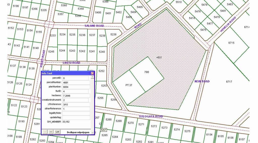
14 Residue Plans 1. Important to close off the paper register 2. Issuance of new parcel number compatible with the new computer register.

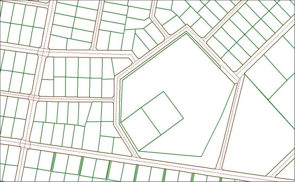
15 Land newly described on this plan Parcel Prior Description Area 1408 Pt ha Total Land transferred out of Land Register 33/260 Parcel Plan LR Area / ha Less ha ha Residual Total Rounded ha ha ha This plan has been prepared solely to provide a unique description for the land in the Land Register referred to in the plan title (below). This plan is not sufficient to redefine the boundaries shown on this plan without a full search of the survey records including the reference plans listed below. Reference Plans: Prepared by: Neil Pullar Drawn by: Filipo Tui Checked: Tufi Auelua APPROVED Plan of Land Comprised in Land Prepared by Ministry of Natural Resources & Environment. Assistant CEO Technical DISTRICT : Tuamasaga Date:../../.. FLUR: VI, Upolu Register Volume 33, Folio 260 Date : September 2008 situated at Palisi Record Map No.: 19F_13C Scale: Not drawn to scale 8106
16 Thank you..
PROJECT INFORMATION DOCUMENT (PID) CONCEPT STAGE Report No.: AB3229 Project Name. Land Registry and Cadastre Modernization Project Region
 CONCEPT STAGE Report No.: AB3229 Project Name. Land Registry and Cadastre Modernization Project Region") PROJECT INFORMATION DOCUMENT (PID) CONCEPT STAGE Report No.: AB3229 Project Name Land Registry and Cadastre Modernization Project Region EUROPE AND CENTRAL ASIA Sector Central government administration
PROJECT INFORMATION DOCUMENT (PID) CONCEPT STAGE Report No.: AB3229 Project Name Land Registry and Cadastre Modernization Project Region EUROPE AND CENTRAL ASIA Sector Central government administration
The Boundary and the Effects of Cadastral Surveying in Cyprus
 The Boundary and the Effects of Cadastral Surveying in Cyprus Aristi Louca, Margarita Fani Surveyor Engineers, Cyprus Association of Rural and Surveying Engineers The History of Cyprus goes back 11000
General Instructions For Surveys and Plans Outside the Provincial Survey System
 May 15, 2018 General Instructions For Surveys and Plans Outside the Provincial Survey System NOTE: This document is a Controller of Surveys Policy manual to be used as a general guideline for the Legal
COUNTRY REPORT FOR THE FIJI ISLANDS
 COUNTRY REPORT FOR THE FIJI ISLANDS UNCE GGIM 2nd SESSION AUGUST 2012 NEW YORK Samuela Naicegucegu Assistant Director for Lands Mapping and Land Information Division Ministry of Lands and Mineral Resources
SCOPE OF PRESENTATION
 INTERNATIONAL SYMPOSIUM AND EXHIBITION ON GEOINFORMATION Global Trends: Geoinformation For The New Economy Studies Toward the Development of Implementation Plan Of Coordinated Cadastral System for Peninsular
Ⅱ-2. The Resurvey Project
 Presenter : JANG, Bong-Bae MLTM Ministry of land,transport and Maritime Affairs KIM, Soon-Tae KCSC Korea Cadastral Survey Corp., JANG, Bong-Bae Ⅰ. INTRODUCTION The Korean modern cadastral system was established
COUNTRY REPORT ON CADASTRE AND LAND REGISTRAION IN IRAN. By: Hamid Berenjkar, IRAN
 COUNTRY REPORT ON CADASTRE AND LAND REGISTRAION IN IRAN By: Hamid Berenjkar, IRAN Key words: Comprehensive Cadastre, Cadastre System, Cadastral Survey, Land Book, Iran ABSTRACT Land registration and cadastral
Moving from a Successful to a Modern Cadastre in LAO PDR
 Moving from a Successful to a Modern Cadastre in LAO PDR Daniel CARTER (Australia) and Bounhom HEUANGSAVATH (Lao PDR) Key Words: cadastre; digital cadastre; land administration systems; South East Asia
Section I General Information
 General Information Table of Contents A. Introduction... I-2 1. Purpose... I-2 2. Scope... I-2 3. Maintenance... I-3 4. Units... I-3 B. Public Relations... I-3 1. General Public... I-3 2. Property Owners...
Establishing Efficient Cadastral Surveying Plan in Accordance with Introducing World Geodetic Reference System in Korea
 Modern Environmental Science and Engineering (ISSN 2333-2581) December 2015, Volume 1, No. 6, pp. 299-303 Doi: 10.15341/mese(2333-2581)/06.01.2015/003 Academic Star Publishing Company, 2015 www.academicstar.us
MnDOT Contract No Exhibit B. Scope of Work. Scope of Work
 MnDOT Contract No. 1032993 Contract General Description The purpose of this contract is to provide the State with the survey accurate re-establishment of designated Public Land Survey section boundaries
Land Management Procedures and Informal Constructions in Cyprus. Marilena Theodorou, Land Surveyor, Cyprus, Dr Chryssy Potsiou, Lecturer NTUA, Greece
 Land Management Procedures and Informal Constructions in Cyprus Marilena Theodorou, Land Surveyor, Cyprus, Dr Chryssy Potsiou, Lecturer NTUA, Greece FIG Working Week 2008 Integrating Generations Objectives
FIG-WB Forum on Land Administration and reform in Sub-Sahara Africa
 FIG-WB Forum on Land Administration and reform in Sub-Sahara Africa Chris Mnyanga Ministry of Lands UNITED REPUBLIC OF TANZANIA] FIG WORKING WEEK, Abuja, NIGERIA 2013-6-10 MAY 2013 Country at Glance UNITED
Developing Infrastructure Framework To Facilitate The Malaysia Multipurpose 3D Cadastre
 Developing Infrastructure Framework To Facilitate The Malaysia Multipurpose 3D Cadastre Sr Dr. Tan Liat Choon Sr Looi Kam Seng University of Technology Malaysia Department of Survey and mapping Malaysia
National Report. Submitted by Cyprus **
 UNITED NATIONS E/CONF.97/5/CRP. 12 ECONOMIC AND SOCIAL COUNCIL Seventeenth United Nations Regional Cartographic Conference for Asia and the Pacific Bangkok, 18-22 September 2006 Item 6 (b) of the provisional
Developing a Prototype Marine Cadastre for Chedabucto Bay, Nova Scotia, Canada or is it St. Margaret s Bay?
 Developing a Prototype Marine Cadastre for Chedabucto Bay, Nova Scotia, Canada or is it St. Margaret s Bay? Dr. Michael Sutherland, CANADA Chair-Elect, Commission 4 FIG EILAT 2009, FIG WORKING WEEK, EILAT,
Tidal Datum Consistency for Marine Cadastre Littoral Zone Commencement in Malaysia
 Tidal Datum Consistency for Marine Cadastre Littoral Zone Commencement in Malaysia Rasheila Rahibulsadri, Abdullah Hisam Omar, Ashraf Abdullah, Wan Muhammad Aizzat Wan Azhar, Chan Keat Lim, Teng Chee Hua,
LAND PARCEL IDENTIFICATION FOR AUTOMATED LAND INFORMATION SYSTEMS
 LAND PARCEL IDENTIFICATION FOR AUTOMATED LAND INFORMATION SYSTEMS D a r r e l l R. D e a n, J r., Teaching Assistant Surveying and Mapping Purdue University R E C O G N IT IO N O F N EED F O R M O R E
Cadastral NSDI Reference Document
 Cadastral NSDI Reference Document Version 12 October 2012 FGDC Subcommittee for Cadastral Data Cadastral NSDI Reference Document Table of Contents 1. Purpose... 1 2. Business Applications... 1 3. Terminology
Addressing Land Sector Opportunities with Geospatial Information in Nepal
 The 20th UNRCC-AP and the 4th UN-GGIM-AP 5-10 October 2015 Jeju Island, Republic of Korea Addressing Land Sector Opportunities with Geospatial Information in Nepal Krishna Raj BC Executive Director Land
The Journey to 100% Electronic Survey. Land Information New Zealand. August 2009
 The Journey to 100% Electronic Survey and Title Lodgement Land Information New Zealand August 2009 Land Information New Zealand Established 1996 Titles, Survey, Geodetic, Electoral 12 locations 500 staff
Implementation of a New Survey Control Standard for New Zealand
 Nic DONNELLY and Matt AMOS, New Zealand Key words: Geodesy, Reference Systems, Datum Maintenance, Standards, Geodetic Networks SUMMARY In September 2009 Land Information New Zealand promulgated a new standard
Responsible and Innovative Land Administration
 Responsible and Innovative Land Administration An Example from Ethiopia 3 RD DECEMBER 2018 Outline A few words about NIRAS Fit-for-purpose: A low-tech disruptive approach? The REILA Project in Ethiopia
Establishing a Land policy reform and GPS Technology implementation in Burkina Faso
 Annual World Bank Conference on Land and Poverty 2013 Establishing a Land policy reform and GPS Technology implementation in Burkina Faso Presentation made by Moha EL-AYACHI, IAV Hassan 2, Morocco Paper
Key Registers in Finland and some views of Cadastre 2035
 Presented at the FIG Working Week 2016, May 2-6, 2016 in Christchurch, New Zealand Key Registers in Finland and some views of Cadastre 2035 FIG Working Week, Christchurch New Zealand May, the 3rd, 2016
Development of Cadastral Survey and Land Ownership Registration System in Mongolia
 Development of Cadastral Survey and Land Ownership Registration System in Mongolia M.Saandar,, Ph. D Vice President, the Mongolian Association of Surveying and Mapping, ( As National Member of FIG ) MonMap
THE XXV FIG INTERNATIONAL CONGRESS IN MALAYSIA Kuala Lumpur, Malaysia, June 2014 at Kuala Lumpur Convention Centre
 CALL FOR PAPERS TO THE XXV FIG INTERNATIONAL CONGRESS IN MALAYSIA Kuala Lumpur, Malaysia, 16 21 June 2014 at Kuala Lumpur Convention Centre Dear Friend and Colleague, It is our privilege and honour to
National Spatial Data Infrastructure development in Republic of Macedonia
 National Spatial Data Infrastructure development in Republic of Macedonia Sonja Dimova, state advisor for geomatics AGENCY FOR REAL ESTATE CADASTRE September 6-th, 2017, Strasbourg AREC competence for
Click to edit Master title style
 Click to edit Master title style Research and Development in Support of the Implementation of PRS92 Data Build-up up and Transformation of Cadastral Maps and Data from Different Local Plane Coordinate
Presented by: Stewart Information International, Inc. Jack McKenna
 Presented by: Stewart Information International, Inc. Jack McKenna Held at the: 2007 ESRI Survey & Engineering GIS Summit San Diego Convention Center San Diego, California June 16-19, 2007 Integrating
The Digital Cadastral Database and the Role of the Private Licensed Surveyors in Denmark
 IRISH INSTITUTE OF SURVEYORS, DUBLIN INSTITUTE OF TECHNOLOGY, 23 NOVEMBER 2005 PUBLISHED IN IIS NEWS, WINTHER 2006. The Digital Cadastral Database and the Role of the Private Licensed Surveyors in Denmark
Mission Planning for a GPS Control Survey Using ESRI ArcMap. August 8, 2004 Mickie Warwick, PLS
 Mission Planning for a GPS Control Survey Using ESRI ArcMap August 8, 2004 Mickie Warwick, PLS Using ArcMap for GPS Mission Planning Surveyors are not tapping into the benefits that can be derived from
Shaping the Cadastral Infrastructure for a Digital Future
 DEPARTMENT OF LANDS PLANNING and the ENVIRONMENT Shaping the Cadastral Infrastructure for a Digital Future Craig Sandy Director Surveys Surveyor General Survey Branch NT Australia Digital Cadastral Databases
The Cadastral Modelling Future and The Land Surveyors Role
 The Cadastral Modelling Future and The Land Surveyors Role Ian Harper Geodata Australia ESRI Survey Summit July 2013 The Land Surveyors Future Role From Custodians of the Cadastre to Custodians of the
GEODESY IN THE CADASTRE AND REGISTER REGULARIZATION PROGRAM
 GEODESY IN THE CADASTRE AND REGISTER REGULARIZATION PROGRAM José Francisco Valverde Calderón Kenneth Ovares Sánchez 1 Cadastre and Register Regularization Program (CRRP) Legal base: law 8154 of 2001. Objective:
LADM in the Republic of Croatia making and testing country profile
 STATE GEODETIC ADMINISTRATION Gruška 20,10 000 Zagreb, Croatia LADM in the Republic of Croatia making and testing country profile Nikola Vučić Danko Markovinović Blaženka Mičević CONTENTS INTRODUCTION
A Method For Building Legal Digital Cadastre Without Using Cadastral Measurements Field Book Data Is It Accurate Enough?
 A Method For Building Legal Digital Cadastre Without Using Cadastral Measurements Field Book Data Is It Jad JARROUSH, Dmitri BRICKMAN, Israel Key words: Digital Cadastre, Least Squares Cadastral Computations,
1. LAND INFORMATION NEW ZEALAND : CONTACT DETAILS
 Cadastral Survey Guidelines Hardcopy Plans LINZ CONTACT DETAILS Chapter 1 - Page 1 1. LAND INFORMATION NEW ZEALAND : CONTACT DETAILS Phone: 0800 ONLINE 0800 665 463 Email: info@linz.govt.nz National Office
PROJECT INFORMATION DOCUMENT (PID) APPRAISAL STAGE Report No.: PIDA Project Name. Region Country Sector(s) Theme(s)
 APPRAISAL STAGE Report No.: PIDA Project Name. Region Country Sector(s) Theme(s)") Public Disclosure Authorized Public Disclosure Authorized Public Disclosure Authorized Public Disclosure Authorized Project Name Region Country Sector(s) Theme(s) Lending Instrument Project ID Borrower(s)
Public Disclosure Authorized Public Disclosure Authorized Public Disclosure Authorized Public Disclosure Authorized Project Name Region Country Sector(s) Theme(s) Lending Instrument Project ID Borrower(s)
LIS a motivation for SDI initiative
 Eric Mwaikambo Ardhi University Dar es Salaam Tanzania Overview Status of LIS in Tanzania Relationship between SDI and LIS Spatial Standards LIS a motivation for SDI initiative Conclusion & Recommendations
Urban-Rural Interrelationship for Sustainable Environment
 Urban-Rural Interrelationship for Sustainable Environment Marrakech 2-52 5 December 2003 Department of Lands and Survey - The Modernization Journey A Paper presented by Eng. Sameer Abbadi Surveying and
BY THE GRACE OF GOD ALMIGHTY MINISTER OF ENERGY AND MINERAL RESOURCES
 DEPARTMENT OF ENERGY AND MINERAL RESOURCES REPUBLIC OF INDONESIA REGULATION OF MINISTER OF ENERGY AND MINERAL RESOURCES NUMBER 02 YEAR 2009 CONCERNING GUIDANCE IN THE ASSIGNMENT OF GEOTHERMAL PRELIMINARY
Parcel Identifiers for Cadastral Core Data: Concepts and Issues
 Parcel Identifiers for Cadastral Core Data: Concepts and Issues Nancy von Meyer, Bob Ader, Zsolt Nagy, David Stage, Bill Ferguson, Katie Benson, Bob Johnson, Stu Kirkpatrick, Robert Stevens, Dan Mates
THE APPLICATION OF GIS AND LIS Solutions and Experiences in East Africa. Lenny Kivuti
 Using GIS and LIS for Planning Sustainable Development Bepic Group CHOGM, Malta 2005 THE APPLICATION OF GIS AND LIS Solutions and Experiences in East Africa Lenny Kivuti 21 November, 2005 Presented by
PCC conference Tällberg. Aspects on development cooperation
 PCC conference Tällberg Aspects on development cooperation PCC conference Tällberg WHO I AM Anders Åberg, Project Leader Posted over seas 10 years Tanzania 1978 1980 Vietnam 1987 1990 Laos 2004 2008 Now
BULGARIAN CADASTRE A GUARANTEE FOR THE OWNERSHIP RIGHTS IN IMMOVABLE PROPERTIES
 4 TH INTERNATIONAL CONFERENCE RECENT PROBLEMS IN GEODESY AND RELATED FIELDS WITH INTERNATIONAL IMPORTANCE February 28 - March 2, 2007, Inter Expo Centre, Sofia, Bulgaria BULGARIAN CADASTRE A GUARANTEE
Spatially Enabled Society Role of the Cadastre
 armasuisse Bundesamt für Landestopografie swisstopo Swiss Federal Directorate for Cadastral Surveying Spatially Enabled Society Role of the Cadastre XXIV FIG International Congress 2010 FIG-Task Force
REQUEST FOR PROPOSALS
 REQUEST FOR PROPOSALS Coastal LiDAR Mapping Closing date and time: 4:00 pm on Monday, May 9, 2016 Closing Location: Regional District of Nanaimo Strategic & Community Development 6300 Hammond Bay Road
The Role of the Swedish Land Information System
 The Role of the Swedish Land Information System In the Business Society Tommy Österberg Swedesurvey 1 SWEDEN 9 million inhabitants 450 000 sq. km 21 Counties 291 Municipalities 4.6 million properties in
Land Administration Trends and Issues in Fiji
 14 th Meeting of the Permanent Committee on GIS Infrastructure for Asia and the Pacific 19-22 August 2008 Land Administration Trends and Issues in Fiji Mr. Kemueli Masikerei Assistant Director Mapping
Slovenian Experiences
 Slovenian Experiences An example from a transition country Milan Brajnik, B.Sc.Geod., Assistant Director milan.brajnik@geod-is.si Geodetic Institute of Slovenia 1000 Ljubljana, Jamova cesta 2 The Identity
Letters of Map Amendment- Out as Shown
 Letters of Map Amendment- Out as Shown While digital Flood Insurance Rate Maps (DFIRM s) have made it easier to determine if a structure (or building site) is in the special flood hazard area (SFHA), many
Aspect of preliminary activities in the function of supporting NSDI
 Sonja DIMOVA, Republic of Macedonia Key words: e-governance, geospatial data, NSDI, INSPIRE, metadata SUMMARY The successful establishment of the NSDI in the true sense of the word cannot be performed
Research Report. For. The Land Surveying Division. The Hong Kong Institute of Surveyors. Land Boundary Survey System for the Title
 Research Report For The Land Surveying Division The Hong Kong Institute of Surveyors Land Boundary Survey System for the Title Registration System of Hong Kong 1 October 2007 to 30 September 2008 By Alice
Well Survey Requirements
 Well Survey Requirements Directive PNG003 November 2015 Revision 1.0 Governing Legislation: Act: The Oil and Gas Conservation Act Regulation: The Oil and Gas Conservation Regulations, 2012 Record of Change
Quality Improvement of the Real Estate Cadastre in Serbia
 , Serbia Key words: quality improvement, real estate information, quality assurance, Serbia SUMMARY The concept of cadastral modernization in the Republic of Serbia was defined in 1992, and it is being
International funding projects in Republic Geodetic Authority
 International funding projects in Republic Geodetic Authority Serbia: Republic Geodetic Authority Workshop Exploring Funding Instruments for NMCA 7-8 November 2012 Republic Geodetic Authority Republic
Surveyor General s Report
 Surveyor General s Report Susan F. MacGregor O.L.S. Surveyor General Mapping and Information Resources Branch Ministry of Natural Resources and Forestry Queen s Printer for Ontario, 2017 The Ministry of
Generic land administration business. FAO Workshop Rome, November 18-19,
 Generic land administration business FAO Workshop Rome, ovember 18-19, 2010 18.11.2010 1 Objectives Agree about what is the core land administration business common to all countries Derive the corresponding
Meeting the Changing National Geospatial Information Needs. Palitha Udayakantha Surveyor General - Sri Lanka
 Meeting the Changing National Geospatial Information Needs Palitha Udayakantha Surveyor General - Sri Lanka Sri Lanka Location Latitude 5 55 10-9 50 6 North Longitude 79 31 19-81 52 36 East Area 65610
Cadastral Futures building a new vision for the nature and role of cadastres. XXIV FIG International Congress Sydney, April 11-15
 Cadastral Futures building a new vision for the nature and role of cadastres XXIV FIG International Congress Sydney, April 11-15 Rohan Bennett, Abbas Rajabifard, Mohsen Kalantari, Jude Wallace, Ian Williamson
LAND CADASTRE AND BUILDING CADASTRE IN SLOVENIA: CURRENT SITUATION AND POTENTIAL OF 3D DATA
 3D Cadastres Organizational and Governmental Aspects LAND CADASTRE AND BUILDING CADASTRE IN SLOVENIA: CURRENT SITUATION AND POTENTIAL OF 3D DATA EMA POGORELČNIK AND MARINA KOROŠEC Surveying and Mapping
Cadastre: definitions
 Introduction New vision towards a multipurpose cadastral system to support land management in Morocco Moha EL-AYACHI, El Hassane SEMLALI, Mohamed ETTARID, Driss TAHIRI, Institut Agronomique et Vétérinaire
Map Modernization Modernization Program
 FEMA Map Modernization Program Presented to Maryland Association of Floodplain and Stormwater Managers October 27, 2005 Map Modernization Program Autorun.exe 2 Map Modernization Program Outline Map Mod
Flood Hazard Modelling
 Flood Hazard Modelling Identification Information Dataset Name: Rapid Flood Hazard Model, Detailed Flood Hazard Model Dataset Abstract: The flood hazard model identifies areas that may be subject to flooding
Good Land Governance for the 2030 Agenda
 Good Land Governance for the 2030 Agenda Addis Ababa, Ethiopia 20-22 April, 2014 Role of Geospatial Information in Good Land Policy and Governance Oumar Sylla UN-Habitat/GLTN oumar.sylla@unhabitat.org
Challenges for the multi purpose cadastre
 Jens RIECKEN, Markus SEIFERT, Germany Key words: Multi purpose cadastre, 3d-cadastre, land use, SDI, solar cadastre SUMMARY Over the past 30 years, with the progress of information technologies the development
A beautiful setting. The Evolving Role of Cadastral Systems in Support of Good Land Governance. Setting the scene
 The Evolving Role of Cadastral Systems in Support of Good Land Governance Prof. Stig Enemark President Aalborg University, Denmark THE DIGITAL CADASTRAL MAP FIG COMMISSION 7 OPEN SYMPOSIUM KARLOVY VARY,
Public Works and Infrastructure Committee. Executive Director, Engineering & Construction Services Director, Purchasing and Materials Management
 STAFF REPORT ACTION REQUIRED PW16.2 Non-competitive Contracts with Cansel Survey Equipment Inc., Leica Geosystems Ltd., and Topcon Positioning Systems for Proprietary Maintenance, Repairs and Parts of
Progress Report on Green Paper. Dr. Paddy Prendergast. on behalf of the. IIS Commission on Land Registration
 Progress Report on Green Paper By Dr. Paddy Prendergast on behalf of the IIS Commission on Land Registration Paddy Prendergast - Chair Brendan Sweeny - Hempenstall Surveys Paul Corrigan - P Corrigan Associates
New Mexico Board of Licensure for Professional Engineers and Professional Surveyors
 New Mexico Board of Licensure for Professional Engineers and Professional Surveyors Title 12, Chapter 8, Part 2, New Mexico Administrative Code [12.8.2 NMAC] MINIMUM STANDARDS FOR SURVEYING IN NEW MEXICO
Coastal Zone Management Land Administration Capacity Building
 Closing Address Prof. Stig Enemark President 6th FIG Regional Conference Coastal Areas and Land Administration - Building the Capacity San José, Costa Rica, 12 15 November 2007 Three Main Themes Coastal
Republic of Bulgaria
 Geodesy, Cartography and Cadastre Agency Republic of Bulgaria www.cadastre.bg 24. 01. 2018 г., гр. София The Cadastre Legislation in Bulgaria - historical reference 1908 г. The Cadastre Act The objective
Rules for Cadastral Survey 2010
 Rules for Cadastral Survey 2010 LINZS65000 24 May 2010 www.linz.govt.nz Under section 49 of the Cadastral Survey Act 2002, I hereby make the Rules for Cadastral Survey 2010 These Rules are effective from
How a Cadaster Might Look Like in Finland in the Year 2035?
 How a Cadaster Might Look Like in Finland in the Year 2035? Mr. MARKKU Eino Olavi MARKKULA, Finland Key words; Cadastre, Coordinates, Digitised Process, Key Registers, Land Register Summary The Finnish
The Croatian Surveyor Guaranteeing Land Property
 Croatian Chamber of Chartered Geodetic Engineers Zagreb, Croatia www.hkoig.hr The Croatian Surveyor Guaranteeing Land Property Ph. D. Danko Markovinović The Cadastral Surveyor paving the Way to the Future
Land Administration and Spatial Enablement Victoria s Experience. Chris McRae, Executive Director Land Victoria
 Land Administration and Spatial Enablement Victoria s Experience Chris McRae, Executive Director Land Victoria 4 th UN Land Administration Forum, October 2011 Outline About Land Victoria Land Victoria
CADASTRE SURVEY PRACTICE (SGHU 4323)
") CADASTRE SURVEY PRACTICE (SGHU 4323) WEEK 11-eCADASTRE SR DR. TAN LIAT CHOON 07-5530844 016-4975551 1 OUTLINE Coordinated Cadastral System National Digital Cadastral Database Multipurpose Cadastre 3D Cadastre
CADASTRE SURVEY PRACTICE (SGHU 4323) WEEK 11-eCADASTRE SR DR. TAN LIAT CHOON 07-5530844 016-4975551 1 OUTLINE Coordinated Cadastral System National Digital Cadastral Database Multipurpose Cadastre 3D Cadastre
The Development of the Austrian Cadastre from Documentation to an Integrated Planning and Decision Support System
 The Development of the Austrian Cadastre from Documentation to an Integrated Planning and Decision Support System WPLA - Working Party on Land Administration 15-17 October 2014, Vienna, Austria Wernher
Functional system for cadastral plans
 , Republic of Macedonia Key words: Cadastre, Digital plans, Data, System SUMMARY The analysis shows that the real estate market in Republic of Macedonia grows daily. With the expansion of this market increases
Cadastre in Addis Ababa. Status and future development
 Status and future development Dr.-Ing. Paul Hartfiel Mülheim, 1. Oct. 2010-1 - Addis Ababa Capital of Ethiopia Area population 540 km² > 3,200,000 (rapidly growing) 2,300,000 in 1994 > 22% of all urban
Viability of a Coordinated Cadastre in New South Wales
 University Of Southern Queensland Faculty of Engineering and Surveying Viability of a Coordinated Cadastre in New South Wales A dissertation submitted by Wayne Edmund Stoeckl in fulfilment of the requirements
Introduction to Land Tenure Administration
 Introduction to Land Tenure Administration Karol Boudreaux Land Tenure & Resource Rights Practice Lead, The Cloudburst Group January 22, 2018 January 22, 2018 1 WHAT WE LL COVER Background and Definitions
E fficient L and A dministr ation E ncour ages P r oper ty M ar k ets. surveying companies at Project commencement. Key Messages
 Secur ing Pr oper ty R ights and I ncr easing R eal E state Pr oductivity in F Y R M acedonia Victoria Stanley, Denis Boskovski and Samantha De Martino Key Messages Before 2005, FYR Macedonia did not have
COORDINATED CADASTRES - A KEY TO BUILDING FUTURE GIS
 Proceedings of the Regional Conference on Managing Geographic Information Systems for Success, Melbourne, 3-4 July, pp.60-69 (1996). COORDINATED CADASTRES - A KEY TO BUILDING FUTURE GIS Ian P.Williamson
GNSS NETWORKS & CADASTRE GNSS AND THE INTERSECTION OF GEODESY AND THE CADASTRE IN KINGDOM OF SAUDI ARABIA SUBJECT TO TALKS
 GNSS NETWORKS & CADASTRE GPS GALILEO GLONASS COMPASS (BEIDOU-2) GNSS AND THE INTERSECTION OF GEODESY AND THE CADASTRE IN KINGDOM OF SAUDI ARABIA 1 SUBJECT TO TALKS GNSS NETWORK From local to global datum
CURRENT TREND IN GEOINFORMATION TECHNOLOGY INTRODUCTION
 CURRENT TREND IN GEOINFORMATION TECHNOLOGY STUDIES TOWARD THE DEVELOPMENT OF IMPLEMENTATION PLAN OF COORDINATED CADASTRAL SYSTEM FOR MALAYSIA Abd. Majid A. Kadir, Shahrum Ses, Ghazali Desa, Kamalludin
3.11 East Japan Earthquake and Topics related to Land management. Masaru Kaidzu Ibaraki-ken EX-JICA Expert Association
 3.11 East Japan Earthquake and Topics related to Land management Masaru Kaidzu Ibaraki-ken EX-JICA Expert Association The 2011 off the Pacific coast of Tohoku Earthquake Date-Time: March 11, 2011 14:46
Analytical Cadastre in Israel: Restoring Land Boundaries Based on Photogrammetric Tools
 Analytical Cadastre in Israel: Restoring Land Boundaries Based on Photogrammetric Tools Yohanan GAVISH and Prof. Yerach DOYTSHER, Israel Key words: analytical cadastre; photogrammetry; restoring land boundaries;
Land Markets and Land Rights in support of the Millennium Development Goals
 Land Markets and Land Rights in support of the Millennium Development Goals A Global Perspective Prof. Stig Enemark President Aalborg University, Denmark 3rd LAND ADMINISTRATION FORUM FOR THE ASIA AND
IT Solutions in Supporting Rwanda Land Administration System
 Ease of Doing Business Initiative Conference 2016 Digitizing Government business Leveraging ICT to enhance the Business Environment IT Solutions in Supporting Rwanda Land Administration System Pothin MUVARA
Problems and Solution Proposals in Integration of Cadastral Data into Geographical Information System (GIS) in Turkey
 in Turkey") Problems and Solution Proposals in Integration of Cadastral Data into Geographical Information System (GIS) in Turkey Gülgün OZKAN, S. Savas DURDURAN, Ali ERDI and Bilal GIRGIN, Turkey Key words: Cadastre,
Problems and Solution Proposals in Integration of Cadastral Data into Geographical Information System (GIS) in Turkey Gülgün OZKAN, S. Savas DURDURAN, Ali ERDI and Bilal GIRGIN, Turkey Key words: Cadastre,
Implementing Agency Department of Housing, Ministry of Local Government, Urban Development, Housing and Environment
 Public Disclosure Authorized Public Disclosure Authorized Public Disclosure Authorized Public Disclosure Authorized PROJECT INFORMATION DOCUMENT (PID) IDENTIFICATION/CONCEPT STAGE Report No.: PIDC56649
Registration of a Lease Long Term Lease. Guidance
 Registration of a Lease Long Term Lease Guidance Contents Introduction... 3 Registration Authority Office... 3 The Registrar s main functions under Real Property Regulations 2015 are:... 3 Opening Hours...
Development of the New Cadastral Survey System in Tanzania
 Samwel S. KATAMBI, Tanzania Keywords: Cadastral Survey System, Cadastre, Land Administration, NSDI. SUMMARY In recent years the demand for cadastral survey informations in Tanzania has been increasing
Strata Plan Fast Facts
 December 2015 ISSN: 2201-4292 Title: Strata Plan Fast Facts ISSN: 2201-4292 Land and Property Information www.lpi.nsw.gov.au Copyright Crown in right of New South Wales through Land and Property Information
FIG Congress 2010 Facing the Challenges Building the Capacity Sydney, Australia, April
 Setting up the infrastructure for improving the development of Cadastre in Greece Dr. Dimitris ROKOS, Dr. Konstantinos KYRIAZIS and Dr. Panos LOLONIS KTIMATOLOGIO S.A. (Hellenic Cadastre) Source: wikipedia
Cadastral Framework Standards
 Cadastral Framework Standards The goal of the Data Standards and Recommendations Committee is to provide recommendations and guidelines to Indiana GIS user communities to facilitate the collection, maintenance
CHAPTER 9.03 LAND SURVEY ORDINANCE and Subsidiary Legislation
 TURKS AND CHAPTER 9.03 LAND SURVEY ORDINANCE and Subsidiary Legislation Revised Edition showing the law as at 31 August 2009 This is a revised edition of the law, prepared by the Law Revision Commissioner
Smart Infrastructure Benefits and Key Players from a Global Perspective
 Smart Infrastructure Benefits and Key Players from a Global Perspective Spatial@gov 2010 October 5-7 Canberra Jude Wallace and Abbas Rajabifard Centre for Spatial Data Infrastructures and Land Administration