GEODESY IN THE CADASTRE AND REGISTER REGULARIZATION PROGRAM
|
|
|
- Buck Pitts
- 5 years ago
- Views:
Transcription

1 GEODESY IN THE CADASTRE AND REGISTER REGULARIZATION PROGRAM José Francisco Valverde Calderón Kenneth Ovares Sánchez 1
2 Cadastre and Register Regularization Program (CRRP) Legal base: law 8154 of Objective: To improve the legal security of land ownership rights How: formation of national cadastre and union of cadastral and register information 2
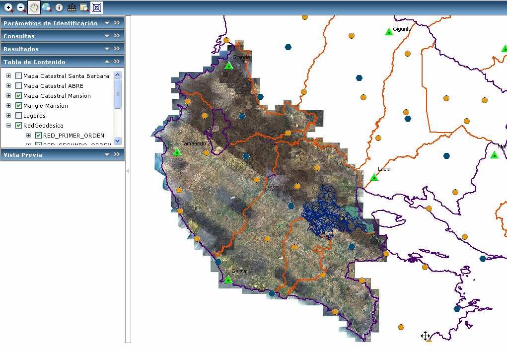
3 The CRRP is conformed by three Components Components Component 1: Formation of cadastre and union of cadastral and registrar information Implementation of two SDI: the National System of Territorial Information (SNIT) and System of Land Registration Information (SIRI) 3
4 Component II: Regularization of property rights relating to property in state lands National Parks Forest Reserves Indigenous territories Borders with Nicaragua and Panama Others Component III: Training the local governments in the use of cadastral information 4
5 SNIT 5
6 Old Old conventional reference system of Costa Rica Datum: Ocotepeque, Honduras Ellipsoid: Clark 1866 Projection: Conical of Lambert Basic Cartography scale 1:
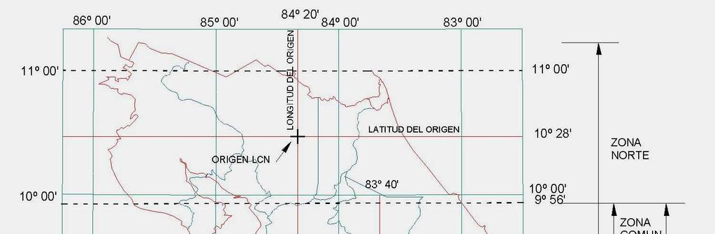
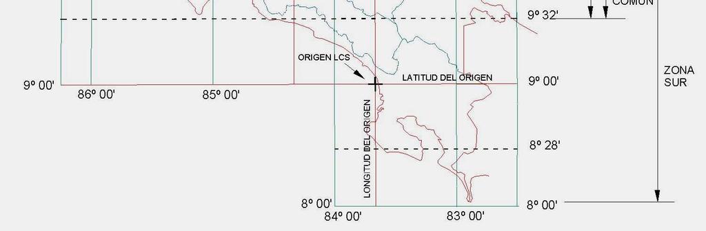
7 Two projections in Costa Rica 7
8 In what reference system and cartographic projection we will work? 8
9 Definition of the new reference system Answer: is necessary define a new reference system for Costa Rica, consistent with the moderns concepts of geodesy, accessible with GPS. This system, named CR05, is linked to International Terrestrial Reference Frame, epoch 2000 (ITRF00) and the epoch of their definition is to= 2005,83 9
10 Definition of the new reference system This system is accessible through passive geodetic network (in the short term, we will install 8 active stations) 10
11 Definition of the new reference system The process to define the reference system was coordinated by CRRP and we have the support of the National Geographic Institute and the National Cadastre A National Consultant was responsible to give technical advice, to design and calculate the geodetic network and define the cartographic projection 11

12 Link to ITRF00 MANA = Nicaragua GCGT = Islas Caimán ZSU1 = Puerto Rico CRO1 = Islas Vírgenes 12
13 Passive Geodetic Network of Costa Rica 13

14 Continuously Operating Network 14
15 Cartographic Projection This replaced the Lambert projection, defined in the second half of century 20 (Costa Rica was two projection: Costa Rica North and Costa Rica South, both Lambert Projection) The new cartographic projection, is named CRTM05. This is a Gauss-Kr Krüguer projection, adapted to Costa Rica The central meridian is 84 W and the scale factor is 0,9999 in the central meridian 15
16 Projection CRTM05 85º 30' 84º 00' 82º 30' NICARAGUA km PANAMA MERIDIANO CENTRAL 16
17 Applications CR05 is the official reference system since All the geodesic, topographic, cadastral and photogrammetryc works, taking place in Costa Rica, must use this reference system SDI s (SNIT, SIRI) Mapping Measurement of natural recourses Commercial applications 17
18 Cadastral areas, phase 1 Istaru- Parismina Tempisque Río Grande Heredia Sur 18
19 Cadastral Areas, State Properties 19
20 Applications A very important work the that we are doing is ordering the coastal areas of Costa Rica According with our legal system, the first 50 m from level curve 1,15 m are a public areas, property of the state The local governments can give in concession the restricted area 20

21 Coast Ordering Height 1,15 m Restricted Area Public Area 50 m 150 m 21
22 Next geodetic projects in short term Install the Continuously Operating Network (December 2009-january 2010) Review of the vertical reference system (in process) Recuperation and analysis of gravimetric data (in process) Cooperate with SIRGAS 22
23 The CRRP considered important give to know their works and products, like form to impulse the integration of territorial information, allowing increase the knowing and rational use of the recourses And for that, is necessary an actual geodetic reference system (CR05), easily accessible and only for the whole country 23
24 Conclusions The old old reference system, linked to datum Ocotepeque was replaced by a new reference system, named CR05, linked to ITRF00 The Lambert projection was replaced by Gauss-Kruguer projection named CRTM05 In the short term, 8 active stations will be installed We want contribute with the objectives of SIRGAS, sharing the results of the projects. 24
25 GEODESY IN THE CADASTRE AND REGISTER REGULARIZATION PROGRAM By José Francisco Valverde Calderón Kenneth Ovares Sánchez Thank You for your attention 25
LADM in the Republic of Croatia making and testing country profile
 STATE GEODETIC ADMINISTRATION Gruška 20,10 000 Zagreb, Croatia LADM in the Republic of Croatia making and testing country profile Nikola Vučić Danko Markovinović Blaženka Mičević CONTENTS INTRODUCTION
Aspect of preliminary activities in the function of supporting NSDI
 Sonja DIMOVA, Republic of Macedonia Key words: e-governance, geospatial data, NSDI, INSPIRE, metadata SUMMARY The successful establishment of the NSDI in the true sense of the word cannot be performed
Republic of Bulgaria
 Geodesy, Cartography and Cadastre Agency Republic of Bulgaria www.cadastre.bg 24. 01. 2018 г., гр. София The Cadastre Legislation in Bulgaria - historical reference 1908 г. The Cadastre Act The objective
The Boundary and the Effects of Cadastral Surveying in Cyprus
 The Boundary and the Effects of Cadastral Surveying in Cyprus Aristi Louca, Margarita Fani Surveyor Engineers, Cyprus Association of Rural and Surveying Engineers The History of Cyprus goes back 11000
LADM in the Republic of Croatia Making and Testing Country Profile
 Nikola VUČIĆ, Danko MARKOVINOVIĆ and Blaženka MIČEVIĆ, Croatia Key words: LADM, Croatian Cadastre, Land Book, Class, Testing SUMMARY Land Administration Domain Model (LADM) covers basic information related
BULGARIAN CADASTRE A GUARANTEE FOR THE OWNERSHIP RIGHTS IN IMMOVABLE PROPERTIES
 4 TH INTERNATIONAL CONFERENCE RECENT PROBLEMS IN GEODESY AND RELATED FIELDS WITH INTERNATIONAL IMPORTANCE February 28 - March 2, 2007, Inter Expo Centre, Sofia, Bulgaria BULGARIAN CADASTRE A GUARANTEE
Topographic Signs Important Context of 3D Cadastre
 STATE GEODETIC ADMINISTRATION Gruška 20,10 000 Zagreb, Croatia Delft University of Technology Faculty of Architecture and the Built Environment Department OTB GIS Technology Section Topographic Signs Important
Cadastre: definitions
 Introduction New vision towards a multipurpose cadastral system to support land management in Morocco Moha EL-AYACHI, El Hassane SEMLALI, Mohamed ETTARID, Driss TAHIRI, Institut Agronomique et Vétérinaire
Parcel Boundaries in the Czech Republic
 Parcel Boundaries in the Czech Republic CZECH REPUBLIC Jiri Rydval, Libor Tomandl Czech Office for Surveying, Mapping and Cadastre inhabitants - 10.3 million territory 78,865 km 2 2 Contents: 1. A parcel
(No ) (Approved December 29, 2009) AN ACT
 (Approved December 29, 2009) AN ACT") (S. B. 1204) (No. 216-2009) (Approved December 29, 2009) AN ACT To provide that the submittal of all plans to the Municipal Revenue Collection Center for the registration of a property shall be done in
(S. B. 1204) (No. 216-2009) (Approved December 29, 2009) AN ACT To provide that the submittal of all plans to the Municipal Revenue Collection Center for the registration of a property shall be done in
Slovenian Experiences
 Slovenian Experiences An example from a transition country Milan Brajnik, B.Sc.Geod., Assistant Director milan.brajnik@geod-is.si Geodetic Institute of Slovenia 1000 Ljubljana, Jamova cesta 2 The Identity
Geodetic Infrastructure in Samoa. FIG Pacific Small Islands Developing States Symposium September 2013, Suva, FIJI.
 Geodetic Infrastructure in Samoa. FIG Pacific Small Islands Developing States Symposium 18 20 September 2013, Suva, FIJI. FIG Commission 5 Position and Measurement United Nations Global Geospatial Information
PROPOSAL FOR THE URBAN REAL ESTATE PROPERTY TAX MANAGEMENT DIAGNOSIS IN BRAZIL
 PROPOSAL FOR THE URBAN REAL ESTATE PROPERTY TAX MANAGEMENT DIAGNOSIS IN BRAZIL Marcos A. PELEGRINA and Lia BASTOS Maio de 2009 Geog. Marcos A.. Pelegrina, M.Engº 1 Geog. Marcos A.. Pelegrina, M.Engº 2
ABSTRACT Land Administration System in Lithuania
 ABSTRACT Land Administration System in Lithuania 1. General introduction to the Lithuanian Land Administration System and State Enterprise Centre of Registers ( shortly SECR) Lithuania has established
PCC Conference and Plenary Meeting "Data as a basis of the digital society March 2018, Sofia. Activity of the geodetic NGOs in Bulgaria
 PCC Conference and Plenary Meeting "Data as a basis of the digital society 13-15 March 2018, Sofia Activity of the geodetic NGOs in Bulgaria Union of Surveyors and Land Managers in Bulgaria Chamber of
Annual Meeting 2006 SLOVENIA, BLED RASAS GOFMANAS JAUNIUS GRIGAS RIMANTAS RAMANAUSKAS KESTUTIS TRECIOKAS
 Annual Meeting 2006 SLOVENIA, BLED LAND ADMINISTRATION IN LITHUANIA RASAS GOFMANAS JAUNIUS GRIGAS RIMANTAS RAMANAUSKAS KESTUTIS TRECIOKAS ADMINISTRATIVE STRUCTURE OF LITHUANIA HISTORY OF LAND ADMINISTRATION
Ⅱ-2. The Resurvey Project
 Presenter : JANG, Bong-Bae MLTM Ministry of land,transport and Maritime Affairs KIM, Soon-Tae KCSC Korea Cadastral Survey Corp., JANG, Bong-Bae Ⅰ. INTRODUCTION The Korean modern cadastral system was established
NATIONAL REPORT REPUBLIC OF MACEDONIA
 NATIONAL REPORT REPUBLIC OF MACEDONIA AGENCY FOR REAL ESTATE CADASTRE Department for Geodetic Works Sasho Dimeski, Brankica Stojanovska, Srechko Tasevski REVIEW OF AREC National Cadastral and Mapping Agency
Germany on the way to a 4D-Cadastre
 Germany on the way to a 4D-Cadastre Dr. Jens Riecken (DVW Vicepresident), Ulrich Gruber, Dr. Markus Seifert (DVW WG Geoinformation) TS 9.1 4D Cadastre, Land Domain Models & Concepts 1 Content About my
Land and Geographic Information, an Important Part of the Infrastructure in Sweden
 Land and Geographical Information Land and Geographic Information, an Important Part of the Infrastructure in Sweden Land and Geographic Information, an Important Part of the Infrastructure In Sweden Bo
Institutional Arrangements for Land Administration in Mongolia. R.Gankhuyag Head of Cadastral Division of ALAGaC
 Institutional Arrangements for Land Administration in Mongolia R.Gankhuyag Head of Cadastral Division of ALAGaC Content Historical institutional arrangements Legal environment for land administration Cadastral
Section I General Information
 General Information Table of Contents A. Introduction... I-2 1. Purpose... I-2 2. Scope... I-2 3. Maintenance... I-3 4. Units... I-3 B. Public Relations... I-3 1. General Public... I-3 2. Property Owners...
Role of Republic Geodetic Authority in the Serbian geo-sector
 Role of Republic Geodetic Authority in the Serbian geo-sector Republic Geodetic Authority, Serbia www.rgz.gov.rs EuroGeographics General Assembly 2014 Moldova, Chisinau, 28 th 30 th September 2014 The
SCOPE OF PRESENTATION
 INTERNATIONAL SYMPOSIUM AND EXHIBITION ON GEOINFORMATION Global Trends: Geoinformation For The New Economy Studies Toward the Development of Implementation Plan Of Coordinated Cadastral System for Peninsular
PROJECT INFORMATION DOCUMENT (PID) CONCEPT STAGE Report No.: AB3229 Project Name. Land Registry and Cadastre Modernization Project Region
 CONCEPT STAGE Report No.: AB3229 Project Name. Land Registry and Cadastre Modernization Project Region") PROJECT INFORMATION DOCUMENT (PID) CONCEPT STAGE Report No.: AB3229 Project Name Land Registry and Cadastre Modernization Project Region EUROPE AND CENTRAL ASIA Sector Central government administration
PROJECT INFORMATION DOCUMENT (PID) CONCEPT STAGE Report No.: AB3229 Project Name Land Registry and Cadastre Modernization Project Region EUROPE AND CENTRAL ASIA Sector Central government administration
Status and Perspectives of the Geodesy, Cartography and Cadastre Authority Availability of Geographic Information in Slovakia.
 Status and Perspectives of the Geodesy, Cartography and Cadastre Authority Availability of Geographic Information in Slovakia Hedviga Májovská Geodesy, Cartography and Cadastre Authority of the Slovak
The Multipurpose Hungarian Unified Land Registry System
 The Multipurpose Hungarian Unified Land Registry System András Osskó FIG Working Week Integrating Generation Stockholm, Sweden 14-19 June 2008 Republic of Hungary is located in Central Europe Neighbouring
FIG-WB Forum on Land Administration and reform in Sub-Sahara Africa
 FIG-WB Forum on Land Administration and reform in Sub-Sahara Africa Chris Mnyanga Ministry of Lands UNITED REPUBLIC OF TANZANIA] FIG WORKING WEEK, Abuja, NIGERIA 2013-6-10 MAY 2013 Country at Glance UNITED
Cadastre and Land Registration in Europe
 Annex A: Questionnaire 2007 for Information Resource Cadastre and Land Registration in Europe Introduction This questionnaire is based on the EuroGeographics vision document 'Cadastre and Land Registration
Unified Land Administration for a Better Spatial Infrastructure
 Unified Land Administration for a Better Spatial Infrastructure Gyula IVÁN Institute of Geodesy, Cartography & Remote Sensing FÖMI (HUNGARY) Open Symposium 30th Korean Cadastral Seminar & FIG Commission
Croatian SDI: a Tool for Accelerated Development of the Geo-Conscious Society
 STATE GEODETIC ADMINISTRATION Croatian SDI: a Tool for Accelerated Development of the Geo-Conscious Society Prof.Dr.Sc. Željko Bačić, Mr.Sc. Ljerka Rašić FIG Working Week 2009 - Surveyors Key Role in Accelerated
Development of Cadastral Survey and Land Ownership Registration System in Mongolia
 Development of Cadastral Survey and Land Ownership Registration System in Mongolia M.Saandar,, Ph. D Vice President, the Mongolian Association of Surveying and Mapping, ( As National Member of FIG ) MonMap
Use of data in Ukraine for sustainable economic growth. Oleksandr Maliuk State Service of Ukraine for Geodesy, Cartography and Cadastre
 Use of data in Ukraine for sustainable economic growth Oleksandr Maliuk State Service of Ukraine for Geodesy, Cartography and Cadastre Kehl, 2017 Content of the presentation Ukraine & StateGeoCadastre:
Establishing Efficient Cadastral Surveying Plan in Accordance with Introducing World Geodetic Reference System in Korea
 Modern Environmental Science and Engineering (ISSN 2333-2581) December 2015, Volume 1, No. 6, pp. 299-303 Doi: 10.15341/mese(2333-2581)/06.01.2015/003 Academic Star Publishing Company, 2015 www.academicstar.us
REPUBLIC OF BULGARIA LAND ADMINISTRATION REVIEW BACKGROUND INFORMATION
 REPUBLIC OF BULGARIA LAND ADMINISTRATION REVIEW BACKGROUND INFORMATION I. GENERAL INFORMATION Geography and demography Republic of Bulgaria is located in the eastern part of Balkan Peninsula. It is in
New Trends In Development Of Agricultural Land Consolidation In The Russian Federation
 New Trends In Development Of Agricultural Land Consolidation In The Russian Federation Alexander SAGAYDAK and Anna SAGAYDAK, Russian Federation Key words: Agricultural Land Consolidation, Agricultural
Amalia Velasco Carlos Alonso Luis Virgos Fernando Serrano
 Inspire services of the Spanish Directorate General for Cadastre and its use to resolve an old problem of coordination between Spanish Cadastre and Land Registry. Amalia Velasco Carlos Alonso Luis Virgos
LIS a motivation for SDI initiative
 Eric Mwaikambo Ardhi University Dar es Salaam Tanzania Overview Status of LIS in Tanzania Relationship between SDI and LIS Spatial Standards LIS a motivation for SDI initiative Conclusion & Recommendations
AREC responsibilities, data and registries and the way of their distribution
 Data as a basis of the digital society PCC, 13-15 March 2018, Sofia AREC responsibilities, data and registries and the way of their distribution Vlatko Dimovski Agency for Real Estate Cadastre (AREC) the
International funding projects in Republic Geodetic Authority
 International funding projects in Republic Geodetic Authority Serbia: Republic Geodetic Authority Workshop Exploring Funding Instruments for NMCA 7-8 November 2012 Republic Geodetic Authority Republic
Country Profile for the Cadastre of the Czech Republic Based on LADM
 Country Profile for the Cadastre of the Czech Republic Based on LADM Karel Janečka 1, Petr Souček 2 1 University of West Bohemia, Pilsen, Czech Republic 2 Czech Office for Surveying, Mapping and Cadastre,
The implementation of the European Land Registry Document in EU Member States
 The implementation of the European Land Registry Document in EU Member States Presentation by the ELRN member by Republic of Poland Marta Rekawek-Pachwicewicz Polish Association of Registrars, Cracow Regional
Land Administration System in Russian Federation
 Sergey VOLKOV, Russia Key words: land administration, market economy, land management, land resources. SUMMARY Principle source of economic and social development of Russian Federation in XXI century will
Coastal Zone Management Land Administration Capacity Building
 Closing Address Prof. Stig Enemark President 6th FIG Regional Conference Coastal Areas and Land Administration - Building the Capacity San José, Costa Rica, 12 15 November 2007 Three Main Themes Coastal
REFORM OF LAND CADASTRE IN LITHUANIA
 REFORM OF LAND CADASTRE IN LITHUANIA Romualdas KASPERAVICIUS, Lithuania Key words: ABSTRACT Main aim for every Government is to create legal, financial and organisational circumstances for real property.
NOTICE OF REGISTRATION. Re: Request for Inspection PANAMA: Land Administration Project (Loan No PAN)
") INTERNATIONAL BANK FOR RECONSTRUCTION AND DEVELOPMENT INTERNATIONAL DEVELOPMENT ASSOCIATION INTERNATIONAL BANK FOR RECONSTRUCTION AND DEVELOPMENT 1818 H Street, NW Phone: (202) 458-5200 INTERNATIONAL DEVELOPMENT
INTERNATIONAL BANK FOR RECONSTRUCTION AND DEVELOPMENT INTERNATIONAL DEVELOPMENT ASSOCIATION INTERNATIONAL BANK FOR RECONSTRUCTION AND DEVELOPMENT 1818 H Street, NW Phone: (202) 458-5200 INTERNATIONAL DEVELOPMENT
The Croatian Surveyor Guaranteeing Land Property
 Croatian Chamber of Chartered Geodetic Engineers Zagreb, Croatia www.hkoig.hr The Croatian Surveyor Guaranteeing Land Property Ph. D. Danko Markovinović The Cadastral Surveyor paving the Way to the Future
Implementation of a New Survey Control Standard for New Zealand
 Nic DONNELLY and Matt AMOS, New Zealand Key words: Geodesy, Reference Systems, Datum Maintenance, Standards, Geodetic Networks SUMMARY In September 2009 Land Information New Zealand promulgated a new standard
KCA ORGANIZATION GOVERNMENT OF KOSOVA MINSTRY OF PUBLIC SERVICES GOVERNMENT OF KOSOVA MINSTRY OF PUBLIC SERVICES
 Development of Cadastre and Land Management in Kosovo Prof. Dr. sc. Murat Meha, chief executive Hyzri Llabjani-Cadastral Expert * Hajzer Bublaku-Lawyer FIG Working Week 2004 in Athens, Greece, May 22-27,
Polish Integrated System of Real Estate Information Process of establishing and impact of cadastral data quality
 Polish Integrated System of Real Estate Information Process of establishing and impact of cadastral data quality Head Office of Geodesy and Cartography Jarosław Wysocki AGENDA Legal basis ZSIN architecture
The Boundary Concept Land Management Opportunities for Sustainable Development Provided by the Cadastre 2014 Approach. Jürg KAUFMANN, Switzerland
 The Boundary Concept Opportunities for Sustainable Development Provided by the Cadastre 2014 Approach Jürg KAUFMANN, Switzerland THE BOUNDARY CONCEPT AS A CHANCE FOR SURVEYORS OPPORTUNITIES CREATED BY
TURKISH CHAMBER OF SURVEY AND CADASTRE ENGINEERS (HKMO)
") TURKISH CHAMBER OF SURVEY AND CADASTRE ENGINEERS (HKMO) Capital : Ankara Largest City : İstanbul Area : 783,562 km 2 Population : 78,741,053 Population increase ratio : %1,3 Provinces : 81 The Chamber
TURKISH CHAMBER OF SURVEY AND CADASTRE ENGINEERS (HKMO) Capital : Ankara Largest City : İstanbul Area : 783,562 km 2 Population : 78,741,053 Population increase ratio : %1,3 Provinces : 81 The Chamber
Presented by: Stewart Information International, Inc. Jack McKenna
 Presented by: Stewart Information International, Inc. Jack McKenna Held at the: 2007 ESRI Survey & Engineering GIS Summit San Diego Convention Center San Diego, California June 16-19, 2007 Integrating
Surveying in Austria. Congress Maanmittauspäivät Seinäjoki, 20 th March 2014
 Surveying in Austria Congress Maanmittauspäivät Seinäjoki, 20 th March 2014 Topics Facts, figures Organisational issues of surveying Role of the BEV Products, services The Cadastre Surveying Education
DATR towards e-land Administration in Hungary
 DATR towards e-land Administration in Hungary Gyula IVÁN-Gábor SZABÓ-Zoltán WENINGER-Piroska Zalaba Institute of Geodesy, Cartography and Remote Sensing, Budapest, HUNGARY XXIV. FIG Congress Facing the
3.11 East Japan Earthquake and Topics related to Land management. Masaru Kaidzu Ibaraki-ken EX-JICA Expert Association
 3.11 East Japan Earthquake and Topics related to Land management Masaru Kaidzu Ibaraki-ken EX-JICA Expert Association The 2011 off the Pacific coast of Tohoku Earthquake Date-Time: March 11, 2011 14:46
Recent Developments in Use and Dissemination of Geospatial Data in Germany - Example Lower Saxony
 Recent Developments in Use and Dissemination of Geospatial Data in Germany - Example Lower Saxony Conference Permanent Committee on Cadastre Lithuanian Presidency Vilnius, 22 October 2013 Peter Creuzer
The Contribution of Forest Owners Associations for the Forest Cadastre Implementation. João Gaspar Ana Navarro Ferreira PORTUGAL
 The Contribution of Forest Owners Associations for the Forest Cadastre Implementation João Gaspar Ana Navarro Ferreira PORTUGAL Motivation Lack of forestry cadastre; Unify all FOAs databases with common
Refinement of Cadastral Maps
 Acta Montanistica Slovaca Ročník 16(2011), číslo 4, 242-248 Refinement of Cadastral Maps Alena Berková 1 Making cadastral maps more precise The amended cadastral ordinance takes effect from 1.7. 2009.
Land Cadastre Act. Chapter 1. Passed RT I 1994, 74, 1324 Entry into force (except 3 which entered into force on 1.01.
 Issuer: Riigikogu Type: act In force from: 01.01.2011 In force until: 31.12.2014 Translation published: 24.10.2014 Passed 12.10.1994 RT I 1994, 74, 1324 Entry into force 08.11.1994 (except 3 which entered
Department of Lands and Survey
 Cadastral System in Jordan Department of Lands and Survey Eng. Nedal Al-Sagarat/ Director General Eng. Mouen Sayegh/ IT Manager November, 2011 General Information Historical Background Main Duties Organizational
MEDIUM TERM PROGRAMME
 REPUBLIC OF MONTENEGRO MINISTRY OF FINANCE REAL ESTATE ADMINISTRATION MEDIUM TERM PROGRAMME WORKS ON SURVEY AND DESIGN OF THE REAL ESTATE CADASTRE FOR PERIOD 2008-2013 P o d g o r i c a July, 2007. Zavrsen
Role of spatial planning in modern society
 Republic of Croatia State Geodetic Administration The Role of Cadastre in the Development of Regional and Local Planning Structure in Croatia Zdravko Cesarec and Željko Bačić 1 Role of spatial planning
Cadastral Template 2003
 PCGIAP-Working Group 3 "Cadastre" FIG-Commission 7 "Cadastre and Land Management" Cadastral Template 2003 The establishment of a cadastral template is one of the objectives of Working Group 3 "Cadastre"
Northern Territory (Australia) Spatial Data Infrastructure Now and Beyond
 Spatial Data Infrastructure Now and Beyond") Northern Territory (Australia) Spatial Data Infrastructure Now and Beyond Phillip RUDD and Robert SARIB, Australia Key words: Digital cadastre, Land management, GSDI. SUMMARY The Department of Infrastructure,
Northern Territory (Australia) Spatial Data Infrastructure Now and Beyond Phillip RUDD and Robert SARIB, Australia Key words: Digital cadastre, Land management, GSDI. SUMMARY The Department of Infrastructure,
Implementation Status & Results Nicaragua LAND ADMINISTRATION (P056018)
") Public Disclosure Authorized Public Disclosure Authorized The World Bank Implementation Status & Results Nicaragua LAND ADMINISTRATION (P056018) Operation Name: LAND ADMINISTRATION (P056018) Project Stage:
Public Disclosure Authorized Public Disclosure Authorized The World Bank Implementation Status & Results Nicaragua LAND ADMINISTRATION (P056018) Operation Name: LAND ADMINISTRATION (P056018) Project Stage:
Land Administration And Spatial Data Infrastructures
 Land Administration And Spatial Data Infrastructures Ian WILLIAMSON, Donald GRANT and Abbas RAJABIFARD Centre for SDIs and Land Administration Department of Geomatics University of Melbourne, Australia
Land Registers Interconnection Gabriel Sima European Commission, DG Justice and Consumers
 Land Registers Interconnection Gabriel Sima European Commission, DG Justice and Consumers Contents Context LRI Project status System implementation National establishments for land registration Electronic
Establishing a Land policy reform and GPS Technology implementation in Burkina Faso
 Annual World Bank Conference on Land and Poverty 2013 Establishing a Land policy reform and GPS Technology implementation in Burkina Faso Presentation made by Moha EL-AYACHI, IAV Hassan 2, Morocco Paper
California-Specific Professional Land Surveyor Examination Test Plan
 General Definition of California Professional Land Surveying Practices: The practice of land surveying in the State of California consists of determining, establishing, reporting and mapping the positions,
The Use of Cadastral Information in Projects Financed by the EU: The Hellenic Cadastre
 The Use of Cadastral Information in Projects Financed by the EU: The Hellenic Cadastre Prof. D. Balodimos Vice-President of Ktimatologio S.A. (Hellenic Cadastre) Acknowledgements Dr. Panos Lolonis, Coordinator
Surveying and Mapping Strategy for Supporting the Emerging Land Market in Albania
 No. 2 A L B A N I A S E R I E S September 1997 Surveying and Mapping Strategy for Supporting the Emerging Land Market in Albania Ahmet Jazoj, Spiro Lamani, Leart Lira SURVEYING AND MAPPING STRATEGY FOR
Spatial Data Infrastructure in Sweden
 Spatial Data Infrastructure in Sweden Hans-Erik WIBERG, Sweden Key words: ABSTRACT Sweden was one of the first countries to address Data Infrastructure matters and have during several decades developed
Land Administration Developments in Rwanda
 Land Administration Developments in Rwanda Eugène RURANGWA Expert Group Meeting on secure land tenure new legal frameworks and tools UN-Gigiri, Nairobi, 10-12 November, 2004 Contents Somme figures about
Quality Improvement of the Real Estate Cadastre in Serbia
 , Serbia Key words: quality improvement, real estate information, quality assurance, Serbia SUMMARY The concept of cadastral modernization in the Republic of Serbia was defined in 1992, and it is being
Experience in Innovative Technologies Application to Change Urban Space for Sustainable Territory Development
 IOP Conference Series: Materials Science and Engineering PAPER OPEN ACCESS Experience in Innovative Technologies Application to Change Urban Space for Sustainable Territory Development To cite this article:
Incorporating Sustainable Development Objectives into ICT Enabled Land Administration Systems - Case Study Switzerland
 EXPERT GROUP MEETING ON INCORPORATING SUSTAINABLE DEVELOPMENT OBJECTIVES INTO ICT ENABLED LAND ADMINISTRATION SYSTEMS 9-11 November 2005, Centre for Spatial Data Infrastructures and Land Administration
STATE COMMITTEE OF THE REPUBLIC OF UZBEKISTAN ON LAND RESOURCES, GEODESIES, TO CARTOGRAPHY AND STATE INVENTORY
 STATE COMMITTEE OF THE REPUBLIC OF UZBEKISTAN ON LAND RESOURCES, GEODESIES, TO CARTOGRAPHY AND STATE INVENTORY Development of services in providing information on land resources and real estate, introduction
The Development Strategy for Cadastre and Land Register in Finland
 1 2 The Development Strategy for and Land in Finland Arvo Kokkonen Ministry of Agriculture and Forestry Facts and figures of Finland - land area 304 530 km² - water area 33 615 km² - total area 338 195
PROJECT INFORMATION DOCUMENT (PID) RESTRUCTURING. PA Land Administration
 RESTRUCTURING. PA Land Administration") Project Name Region Sector Project ID Borrower(s) Implementing Agency PROJECT INFORMATION DOCUMENT (PID) RESTRUCTURING PA Land Administration LATIN AMERICA AND CARIBBEAN Natural Resources Management P050595
Project Name Region Sector Project ID Borrower(s) Implementing Agency PROJECT INFORMATION DOCUMENT (PID) RESTRUCTURING PA Land Administration LATIN AMERICA AND CARIBBEAN Natural Resources Management P050595
Australia no longer down under - Official German Surveying and Mapping - Cooperation between the public and the private sector - The German Way
 Official German Surveying and Mapping - Cooperation between the public and the private sector - The German Way Australia no longer down under - Sydney, Australia, 11 16 April 2010 1 Australia no longer
Improving Land Governance in River Senegal Valley Context, Issues and Challenges
 Improving Governance in River Senegal Valley Context, Issues and Challenges Key words: Decentralized Management, Senegal, Cadastre, Registration SUMMARY After presenting economic social and demographic
Country Report SWITZERLAND
 armasuisse Federal Office of Topography, swisstopo Country Report SWITZERLAND Dr. Daniel Steudler Swiss Annual Meeting 2013, FIG-Commission 7 22 October 2013, Yaoundé, Cameroon Basic Dimensions SWITZERLAND
LAW ON CADASTRE AND PROPERTY REGISTER
 LAW ON CADASTRE AND PROPERTY REGISTER Prom. SG. 34/25 Apr 2000, amend. SG. 45/30 Apr 2002, amend. SG. 99/22 Oct 2002, amend. SG. 36/30 Apr 2004, amend. SG. 39/10 May 2005, amend. SG. 105/29 Dec 2005, amend.
Experiences with land consolidation and land banking in Slovenia since 1991
 Experiences with land consolidation and land banking in Slovenia since 1991 Anka LISEC University of Ljubljana Faculty of Civil and Geodetic Engineering anka.lisec@fgg.uni-lj.si University of Ljubljana
The Role of the Swedish Land Information System
 The Role of the Swedish Land Information System In the Business Society Tommy Österberg Swedesurvey 1 SWEDEN 9 million inhabitants 450 000 sq. km 21 Counties 291 Municipalities 4.6 million properties in
Country report, HUNGARY
 Country report, HUNGARY Gyula IVÁN Institute of Geodesy, Cartography & Remote Sensing (FÖMI) HUNGARY FIG Commission 7 Annual Meeting 2009 12-16 October, 2009, Kuala Lumpur, Malaysia Institute of Geodesy,
Hungary is a landlocked, Central European country in the Carpathian Basin
 Brief Overview on Hungarian Land Administration MSc. György Domokos Hungarian Geodetic Surveying Liaison Group CLGE GA Hannover 12 13 October 2012 Hungary is a landlocked, Central European country in the
GNSS NETWORKS & CADASTRE GNSS AND THE INTERSECTION OF GEODESY AND THE CADASTRE IN KINGDOM OF SAUDI ARABIA SUBJECT TO TALKS
 GNSS NETWORKS & CADASTRE GPS GALILEO GLONASS COMPASS (BEIDOU-2) GNSS AND THE INTERSECTION OF GEODESY AND THE CADASTRE IN KINGDOM OF SAUDI ARABIA 1 SUBJECT TO TALKS GNSS NETWORK From local to global datum
Addressing Land Sector Opportunities with Geospatial Information in Nepal
 The 20th UNRCC-AP and the 4th UN-GGIM-AP 5-10 October 2015 Jeju Island, Republic of Korea Addressing Land Sector Opportunities with Geospatial Information in Nepal Krishna Raj BC Executive Director Land
Integrated Cadastral System (ICS) of Poland Supported by the European Union
 of Poland Supported by the European Union") Integrated Cadastral System (ICS) of Poland Supported by the European Union Prof. Hans KNOOP, Germany and Prof. Wojciech WILKOWSKI, Poland Key words: Cadastral System, Cadastral Objects, Computerisation
Integrated Cadastral System (ICS) of Poland Supported by the European Union Prof. Hans KNOOP, Germany and Prof. Wojciech WILKOWSKI, Poland Key words: Cadastral System, Cadastral Objects, Computerisation
Challenges for the multi purpose cadastre
 Jens RIECKEN, Markus SEIFERT, Germany Key words: Multi purpose cadastre, 3d-cadastre, land use, SDI, solar cadastre SUMMARY Over the past 30 years, with the progress of information technologies the development
Land Information Management in Southern Africa Focus on technology management training in Surveying and Mapping in Namibia
 Land Information Management in Southern Africa Focus on technology management training in Surveying and Mapping in Namibia Chris Paresi, Urban and Regional Planning and Geo-Information Management Department,
Integration of Public Service Procedures and Use of Cadastral Data
 Integration of Public Service Procedures and Use of Cadastral Data Signe Rudzite Head of Cadastre and Register Department The State Land Service Vilnius, 21.10.2013 Content General information Current
New Cadastral Mapping in the Czech Republic
 New Cadastral Mapping in the Czech Republic Karel Štencel, Svatava Dokoupilová, Jan Kmínek Czech Office for Surveying, Mapping and Cadastre Basic Data about the Czech Republic Area: 78 866 km 2 Population:
INTEGRATED LAND ADMINISTRATION SYSTEM PROJECT PREPARATION (IBRD Advance no. P459-HR) TERMS OF REFERENCE
 TERMS OF REFERENCE") INTEGRATED LAND ADMINISTRATION SYSTEM PROJECT PREPARATION (IBRD Advance no. P459-HR) TERMS OF REFERENCE SERVICE PROVISION FOR THE SUPPORT TO THE NATIONAL SPATIAL DATA INFRASTRUCTURE (NSDI) DEVELOPMENT
INTEGRATED LAND ADMINISTRATION SYSTEM PROJECT PREPARATION (IBRD Advance no. P459-HR) TERMS OF REFERENCE SERVICE PROVISION FOR THE SUPPORT TO THE NATIONAL SPATIAL DATA INFRASTRUCTURE (NSDI) DEVELOPMENT
Designing for transparency and participation in the Hellenic Cadastral Project
 Designing for transparency and participation in the Hellenic Cadastral Project Dr. Dimitris Rokos Director of Planning and Investments, Hellenic National Cadastre and Mapping Agency S.A. Table of Contents
FIG/FAO International Seminar on State and Public Land Management
 FIG/FAO International Seminar on State and Public Land Management State Land Distribution for the Poor: State Land Identification, Mapping, Classification and Registration By Dr. Sareth Boramy Deputy General
THE INSPECTION PANEL 1818 H Street, N.W. Telephone: (202)
") Public Disclosure Authorized Public Disclosure Authorized Public Disclosure Authorized Public Disclosure Authorized INTERNATIONAL BANK FOR RECONSTRUCTION AND DEVELOPMENT INTERNATIONAL DEVELOPMENT ASSOCIATION
Public Disclosure Authorized Public Disclosure Authorized Public Disclosure Authorized Public Disclosure Authorized INTERNATIONAL BANK FOR RECONSTRUCTION AND DEVELOPMENT INTERNATIONAL DEVELOPMENT ASSOCIATION
A Geocoded Cadastral Fabric as a Precondition for a Sustainable Land Management System
 A Geocoded Fabric as a Precondition for a Sustainable Land Management System Gottfried KONECNY, Germany; J.P. LAUZON, Canada; Abdul Salam MOHAMMED, India Key words: SDI,, Parcel Boundaries, GPS-GNSS, Land