CADASTRE SURVEY PRACTICE (SGHU 4323)
|
|
|
- Derrick Cross
- 5 years ago
- Views:
Transcription
1 CADASTRE SURVEY PRACTICE (SGHU 4323) WEEK 11-eCADASTRE SR DR. TAN LIAT CHOON
2 OUTLINE Coordinated Cadastral System National Digital Cadastral Database Multipurpose Cadastre 3D Cadastre and Marine Cadastre 2
3 COORDINATED CADASTRAL SYSTEM 3
4 Introduction Since 1995, Department of Survey and Mapping Malaysia (DSMM) has embarked on a modernisation program that saw the dramatic computerisation of both its office and field processes of its cadastral survey division. The Digital Cadastral Database was created by capturing the surveyed accurate information of all land parcels. Under the e-cadastre project, a comprehensive nationwide readjustment of the meshwork of parcels will be carried out based on a new geocentric datum concept. The Real Time Kinematic Global Positioning System (RTKGPS) has seen the setting up of permanent stations established to provide precise geocentric positioning to assist the Coordinated Cadastral System implementation. This network is to be implemented to support the e-cadastre project. 4
5 Introduction The current system of cadastral survey is yet unable to capitalise on the advent of satellite based technologies. A complete revamp of the system is required before any improvement to the delivery system could be achieved. The new environment will allow various cadastral survey processes, such as planning, layout design submission, field data capture, completed job submission, quality control and approval, to be carried out remotely via the mobile telecommunication network. Global Positioning System (GPS) will provide real time positioning at centimetre resolution homogenously for the entire country and coordinates will replace relative measurements as the ultimate proof of boundary mark position. Additional features such as building footprint and space images will be incorporated into the new database in a move towards a multipurpose cadastre. 5
6 Introduction There are three main components in e-cadastre, namely Coordinated Cadastral System, Virtual Survey System and Cadastral Data Integrity System. The implementation of a Coordinated Cadastral System is a major part of the e-cadastre project that includes field and office reengineering to reduce processes and increase the use of digital technology. The Virtual Survey System will equip the field surveyor with ICT, total station, GIS and GPS. The surveyor will be able to interact with the system to extract information that is essential in field operations. Most of the work is automated to reduce tedious computation. 6
7 Introduction Cadastral Data Integrity System comprises all the office application related to cadastre, which include pre-survey verification, field survey data computation and verification, digital title plans generation and approval. In order to implement multipurpose 3D cadastre in Malaysia, new requirements are needed to capture the data in threedimensional (on surface, above surface and below surface) to cater for strata, stratum surface. This process will be performed in the Electronic Strata Module consisting of the Strata Lodgement Module, Electronic Strata Survey Module and Strata Verification Module. The Strata Lodgement Module is developed especially to fulfil the requirement of a spatial database for strata, while the Electronic Strata Survey Module is developed to perform strata job verification on the ground and at same time perform data collection, and the Strata Verification Module is developed mainly to fulfil the needs of spatial usage for data checking from field checks. 7
8 Coordinated Cadastral System The Characteristic (Entity) The Aspect (Attribute) Appropriate Data Modeling Unique Parcel Identifier Layered Complete Cadastral Maps Digital Cadastral Database (DCDB) Coordinates CCS Legal (Contributory) Evidence of Boundaries Unique Single Set of Survey Accurate Coordinates GDM2000 Common National Coordinate System Cadastral Survey Practice Cadastral Control Infrastructure Least Square Adjustment Geocentric Cassini/RSO Projection System Based on Highest Geodetic Order Adequate Density Whole-to-Part Survey Concept 8
 Populating DCDB With Survey Accurate Coordinates Automated Re-Coordination System Socio- Economic Related Actions Resurvey Finalized Geocentric")
9 Coordinated Cadastral System GDM2000 Establishing State Cadastral Control Infrastructure (CCI) Legal Organizational Related Actions New Cadastral Survey Tie-Up of Selected Parcel Corners to CCI Development of State Cadastral Control Database (CCDB) Populating DCDB With Survey Accurate Coordinates Automated Re-Coordination System Socio- Economic Related Actions Resurvey Finalized Geocentric Based Cassini & RSO Coordinates In DCDB 9
10 Coordinated Cadastral System Specifications for Cadastral Control Network Densification AREA URBAN SEMI-URBAN RURAL PRIMARY GRID SECONDARY GRID 2.5 km x 2.5 km 10 km X 10 km 10 km X 10 km Connected to PGGN Observation Technique: static Observation Period hr Baseline Relative Accuracy less then 3ppm Coordinates Diff. From 2 Bases Stn. Less than 2 cm 0.5 km X 0.5 km 2.5 km X 2.5 km 2.5 km X 2.5 km Connected to Primary Grid Observation Technique: Rapid Static. Observation Period: min Baseline Relative Accuracy: Less than 3ppm Coordinate Differences From 2 Bases stn.: Less Than 3cm CADASTRAL CONTROL INFRASTRUCTURE PRIMARY GEODETIC GPS NETWORK MALAYSIAN ACTIVE GPS STATIONS CCI PGGN MASS Tertiary : 5, 2.5, 0.5 Spacing First Order: 238 stations Zero Order: 8 Stations Control Network Hierarchy 10
 Employing Whole to the Part Concept and GPS Technology")
11 Coordinated Cadastral System Cadastral Control Infrastructure (CCI) Employing Whole to the Part Concept and GPS Technology 11
12 NATIONAL DIGITAL CADASTRAL DATABASE 12
13 National Digital Cadastral Database Background of DCDB: (NDCDB) Digital Cadastral Database (DCDB) contains all information obtained from cadastral survey jobs related to boundaries of land parcels. The existing DCDB, which covers the entire country, was developed from historical survey data (conversion from hardcopy Certified Plans to digital) as well as from current survey jobs. Coordinates in the DCDB were obtained from several means and contain varying, unpredictable, and un-quantified errors. Uncertainties of surveyed values are typical, but errors are more common in some rural areas. To be able to support a modern cadastral system, an accurate positional record of the cadastre is imperative. The existing DCDB was not designed for this purpose. 13
 Different Types Of Cadastral")


14 National Digital Cadastral Database (NDCDB) Different Types Of Cadastral Coordinates RIGID COORDINATE Homogenous and Systematically Adjusted PLOTTING COORDINATE SYSTEM COORDINATE For cadastral map plotting purposes System/Software generated coordinate based on features location Rigid Coordinate Plotting Coordinate System Coordinate 14

15 System value Surveyed value 15


16 National Digital Cadastral Database (NDCDB) Bowditch Least Squares GPS GPS Bowditch adjustment distributes closing errors linearly but not able to provide a unique coordinates solution. Least Squares adjustment technique determine a unique set of coordinates for each boundary mark from a set of observed values (bearings & distances). 16
17 National Digital Cadastral Database GEODETIC TRIANGULATION PENINSULAR MALAYSIA 6.50 G058 G071 G028 G035 G023 G029 GPS BASED REFERENCE SYSTEM 6.00 G057 G040 G047 G031 G030 G044 G054 G003 G025 G032 G033 G077 G G059 G076 G021 G019 G017 G063 G048 G026 G013 G050 G027 G060 G069 G053 G072 G008 G G024 G022 G037 G034 G005 G G G041 G G001 G074 G075 G070 G061 G073 G009 G036 G011 G G052 G055G065 G068 G038 G020 G066 G012 G G051 G010 G G014 G049 G002 G G084 G043 G045 G056 P075 G018 G P4 17
18 National Digital Cadastral Database (NDCDB) To create the National Digital Cadastral Database (NDCDB), the strategy taken consists of the following: Based on the successful implementation of the Melaka s NDCDB; A homogeneous and seamless database with survey accurate coordinate; Based on the national geocentric datum (GDM2000); Creation of Cadastral Control Infrastructure (CCI); Support the implementation of utility mapping. 18
19 National Digital Cadastral Database (NDCDB) NDCDB is based on a uniform reference system, i.e. Cassini GDM2000. NDCDB is "compatible" with the use of modern technology such as GPS/MyRTKnet. NDCDB have a uniform coordinate accuracy, i.e. 5cm to 10cm. NDCDB just have a "single line" and is "compatible" with GIS technology. NDCDB graphic coordinates are similar to coordinate attributes. NDCDB will help the development of information systems, especially the "MULTI-PURPOSE Cadastre". 19
20 Methodology For Cadastral Data Migration To The New Geocentric Datum For Malaysia (GDM2000) Expected NDCDB Spatial Accuracy GDM2000 Establishment of Cadastral Control Infrastructure (CCI) Using JUPEM MyRTKnet GPS Service Tie-Up of Selected Parcel Corners to CCI CATEGORY Urban/ New Developme nt Std. Dev. Northing ± 5 cm or better Std. Dev. Easting ± 5 cm or better Cadastral Control Spacing 0.5 km Automated Network Adjustment & Re-Coordination System Semi Urban/Rural ± 10 cm or better ± 10 cm or better 2.5 km Re-coordination and Re-population (R&R) NDCDB Total estimated number of boundary marks to be recoordinated is about 40 million boundary marks. 20
21 National Digital Cadastral Database (NDCDB) Methodology Establishment of CCI and State CCDB Repopulation & Re-coordination of DCDB with Survey Accurate Coordinates Establishing State Cadastral Control Infrastructure (CCI) Tie-Up of Selected Parcel Corners to CCI Development of State Cadastral Control Database (CCDB) Populating DCDB with Survey Accurate Coordinates Automated Re-Coordination System Study on Cadastral Survey Procedures Under CCS Cost-Benefit Analysis of CCS Implementation Finalized Geocentric Based Cassini & RSO Coordinates in DCDB 21
22 National Digital Cadastral Database Adjustment (NDCDB) CCDB FORMATION OF CADASTRAL NETWORK Data Integrity Check Connection Line File Data Selection Adjustment RE-COORDINATION USING AN AUTOMATED DATA CONVERSION SYSTEM (ADCS) DCDB Transformation Quality Control Temp NDCDB Editing SURVEY ACCURATE DIGITAL CADASTRAL DATABASE (NDCDB) NDCDB 22

23 National Digital Cadastral Database (NDCDB) 23
 LS 600 Parties JUPEM 300 Parties")

24 National Digital Cadastral Database (NDCDB) LS 600 Parties JUPEM 300 Parties JUPEM2U SUM eqc espek NDCDB District Surveyors CSRS Updating of NDCDB in ekadastre 24
25 MULTIPURPOSE CADASTRE 25


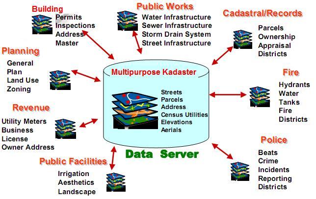
26 Multipurpose Cadastre Underpin A Good GIS NDCDB forms the fundamental Dataset 26


27 FUTURE DIRECTION Multipurpose Cadastre To support the increasing demand for land/geographic information at all levels of government and in the private sector: CORE DATASET: NDCDB Building footprints Transportation Hydrography Street Adresses Geoname Land value Land ownership Demography Control points Land cover Single objects Heights Local names Ownership Pipelines Administrative subdivisions NDCDB 27

28 MPC Component MPC component as shown provides the means for enhancement of delivery system to the public as well as realization of connected government. 28


29 MPC Component NDCDB LARGE SCALE GEOSPATIAL DATA NON- SPATIAL DATA MPC Valuation Ownership Geonames Land value Land use 29
30 Multipurpose Cadastre 30


31 Multipurpose Cadastre From Single Purpose e-kadaster to Multipurpose Cadastre
32 3D CADASTRE AND MARINE CADASTRE 32
33 3D CADASTRE 33
34 3D Cadastre Multiple use of land is increasing. The owner of a parcel of land may possess the rights to the column of air above and the column of soil under that land. At ground level, multiple use of land has resulted in the multiple exercises of rights of the use of the regions above and below ground level and in the division of rights in the ownership column. 34
35 3D Cadastre Pressure on land in urban areas and especially their business centers has led to overlapping and interlocking construction. Even when the creation of property rights to match these developments is available within existing legislation, describing and depicting them in the cadastral registration, poses a challenge. The challenge is how to register overlapping and interlocking construction when projected on the surface in a cadastral registration that registers information on 2D parcels. Although property has been located on top of each other for many years, it is only recently that the question has been raised as to whether cadastral registration should be extended into the third dimension 35
36 The Importance of 3D Cadastre Current cadastre registration systems, bound to ground surface topological and geometrically described parcels, have shown limitations in providing an insight into three-dimensional location of three-dimensional constructions as well the vertical dimension (depth and height) of rights established for three-dimensional constructions. In addition, the cadastre should be able to describe property ownership, including Strata Title ownership. A 3D cadastre is defined as a cadastre that registers and gives insight into rights and restrictions not only on parcels, but also on 3D property units. Thus, a 3D cadastre would be able to handle such conditions as overlapped buildings and utilities that prohibit the property from being registered according to legal and organisational aspects using a 2D cadastre. 36
37 The Importance of 3D Cadastre In the near future, the cadastre will contain updated documentation of public and private rights, ownership, land use and real estate in various spaces. 3D boundaries and parcels in space will be determined by the 3D cadastre that serves the legal and physical objectives. A modern cadastre system should always reflect the existing situation of all property rights, including a mixture of private and public properties. It is necessary to develop a 3D cadastre with its own legal solutions that meet its specific needs. On the other hand, the content and role of a cadastre that is related to three-dimensional properties have not changed significantly, notwithstanding the substantial impact on the cadastre system. The 3D cadastre system should provide information beyond the typical planning data and ensure registered rights above, on and below the surface of a property. Hence, land will be more optimally developed and utilised. 37
38 Practical Solutions (a) Full 3D cadastre Option 1: Combination of infinite parcel columns and volume parcels, i.e. a combined 2D/3D alternative. Option 2: Only parcels that are bounded in 3D volume. (b) 2D/3D hybrid cadastre Option 1: Registration of 2D parcels in all cases of real property registration, and additional registration of 3D legal space in the case of 3D property units. Option 2: Registration of 2D parcels in all cases of real property registration, and additional registration of physical objects. (c) 2D cadastre with 3D tags linked to parcels in current cadastral registration. 38
39 Full 3D Cadastre The concept of a full 3D cadastre introduces property rights in three-dimensional space, which is being subdivided into volume parcels partitioning the three-dimensional space. In this approach, the traditional cadastral map does not have any bearing on the three-dimensional rights that entitle persons to volumes. In other words, rights and restrictions are no longer established only on 2D parcels, but are explicitly related to welldefined volume parcels. Examples of real property objects that are defined in three-dimensional are strata and stratum units. However, to realise this full 3D cadastre solution, significant changes are required in the cadastral survey and mapping registration, land registration, as well as the technical and legislative frameworks. 39
40 Full 3D Cadastre It is possible to establish parcels that are defined with boundaries on the surface because the volume parcels are only established in threedimensional situations. The first option is to convert the conventional parcels representation into three-dimensional; a parcel is defined by the boundary on the surface, which is converted into an indefinite parcel columns and volume parcels that intersects with the surface at the location of the parcel boundary. With the second option, the only property objects that are recognised by the cadastre become volume parcels, forming a complete partition of space. In order to define the extent of ownership in the vertical plane, it requires extensive and complicated overall three-dimensional land title settlements prior to the cadastral survey. Moreover, the relevant land laws need to be amended, and this usually takes a long process. 40
41 2D/3D Hybrid Cadastre The 2D/3D hybrid cadastre solution refers to the integration of the 2D cadastre with the factual situation in three-dimensional space in registering the three-dimensional objects within the three-dimensional cadastral registration. This solution requires the separate legal registration of on-surface parcels and of the three-dimensional situations, which are combined and integrated. The hybrid solution of cadastral registration of the three-dimensional situation is not judicially binding. This means that the exact legal situation still depends on reliable documents like those recorded by Certified Plan in the land registration, with the description of the volume agreed upon in the three-dimensional registration. The three-dimensional representation is the volume to which a person is entitled, i.e. the registration of the three-dimensional object defined by the surface parcel and that is bound by the upper and lower limits. Such registration can also refer to the three-dimensional physical object itself. 41
42 2D/3D Hybrid Cadastre The first option refers to the 3D registration of rights that are already registered with the 2D parcel as the starting point of registration. The second option is the registration of 3D physical objects themselves, which a physical object as the starting point of registration. Constructions (e.g. buildings) are integrated in the cadastral data in the current cadastral registration. The juridical and cadastral concept of ownership and property will remain the same. 42
43 2D Cadastre with 3D Tags 2D cadastre is supplemented with three-dimensional tags solution, the existing 2D cadastre is maintained in its original state, but with external references linking to three-dimensional digital drawing or three-dimensional analogue to represent three-dimensional situations. In this solution, complex threedimensional situations are registered using ad hoc solutions within current registration possibilities, while every right that is registered can be attributed with a reference to a threedimensional representation. The difference between 2D/3D hybrid cadastre and 2D cadastre with three-dimensional tags is that the three-dimensional representations in the second approach are maintained separately and not integrated with the cadastral data. 43
44 3D Cadastre The National Land Code 1965 only allows 3 types of lot/parcel, i.e.: Land Strata Parcel and Land Parcel in strata Scheme Stratum The more efficient of cadastre system in future is to allow 3D lot/parcel including air space and marine space. 44

45 3D Cadastre Stratum 45
![3D SPACE CONCEPTUAL DIAGRAM [ X4,Y4, H1 ] [ X1,Y1, H1 ] [ X3,Y3, H1 ] [ X2,Y2, H1 ]](/docs-images/92/109901452/images/46-1.jpg "TOPOGRAPHY MEAN SEA LEVEL LOWEST ASTRONOMICAL TIDE [ X1,Y1, H2 ] [ X3,Y3, H2 ] [ X2,Y2,")
46 3D SPACE CONCEPTUAL DIAGRAM [ X4,Y4, H1 ] [ X1,Y1, H1 ] [ X3,Y3, H1 ] [ X2,Y2, H1 ] TOPOGRAPHY MEAN SEA LEVEL LOWEST ASTRONOMICAL TIDE [ X1,Y1, H2 ] [ X3,Y3, H2 ] [ X2,Y2, H2 ] 46
![3D SPACE CONCEPTUAL DIAGRAM TOPOGRAPHY [ X4,Y4, H1 ] [ X1,Y1, H1 ] [ X3,Y3, H1 ] [ X2,Y2,](/docs-images/92/109901452/images/47-1.jpg "H1 ] MEAN SEA LEVEL LOWEST ASTRONOMICAL TIDE [ X1,Y1, H2 ] [ X3,Y3, H2 ] [ X2,Y2, H2 ] 47")
47 3D SPACE CONCEPTUAL DIAGRAM TOPOGRAPHY [ X4,Y4, H1 ] [ X1,Y1, H1 ] [ X3,Y3, H1 ] [ X2,Y2, H1 ] MEAN SEA LEVEL LOWEST ASTRONOMICAL TIDE [ X1,Y1, H2 ] [ X3,Y3, H2 ] [ X2,Y2, H2 ] 47
![3D SPACE CONCEPTUAL DIAGRAM [ X4,Y4, H1 ] [ X1,Y1, H1 ] [ X3,Y3, H1 ] [ X2,Y2, H1 ] MEAN](/docs-images/92/109901452/images/48-1.jpg "SEA LEVEL LOWEST ASTRONOMICAL TIDE [ X1,Y1, H2 ] [ X3,Y3, H2 ] TOPOGRAPHY [ X2,Y2, H2 ]")
48 3D SPACE CONCEPTUAL DIAGRAM [ X4,Y4, H1 ] [ X1,Y1, H1 ] [ X3,Y3, H1 ] [ X2,Y2, H1 ] MEAN SEA LEVEL LOWEST ASTRONOMICAL TIDE [ X1,Y1, H2 ] [ X3,Y3, H2 ] TOPOGRAPHY [ X2,Y2, H2 ] 48


49 Overlapping Development Penang KOMTAR and Prangin Mall 49
50 Building above and basement parking below public road 1 Cross sectional 50
51 Building above and basement parking below public road 1 3D parcel 51

52 Melaka Hatten Square 52
53 Sky-bridge above public road 2 Cross sectional 53
54 Sky-bridge above public road 2 3D parcel 54

55 KL Central Multi Storey Complex and Transportation Hub 55

56 Jean Nouvel's Guthrie Theater in Minneapolis 56

57 Interlace Singapore 57

58 Interlace Singapore 58

59 Source: 59
60 The Construction Of MRT Station Need 3D Element 60
61 Multiple-use 4 5 Cross sectional 61
62 Multiple-use 4 5 3D parcels 62


63 3D scenario 63
64 Multipurpose 3D Cadastre 3D cadastre registration system is being developed. Researchers have contemplated adding 3D cadastre objects in the current cadastre data model and information, accessible by the Department of Survey and Mapping Malaysia, State Land and Mines Office, and District Land Office. Unfortunately, the two stated databases, viz. the ekadaster and the etanah database work separately under different authorities, still do not support three-dimensional capability. 64
65 Multipurpose 3D Cadastre The Malaysian Land Administration is based on the Torrens System where the cadastral map and the Document of Title with spatial and textual information are regarded as legal evidence, and are required under the rules and regulations in order to have full institutional coordination. Therefore, a good institution is very important in order to achieve an excellent and reliable cadastre registration system. However, due to historical constraints, it seems quite difficult to realise this unless there is full cooperation from various legal bodies, technical organisations and other landrelated government agencies and private sector participants. 65
66 Multipurpose 3D Cadastre A multipurpose 3D cadastre can be defined as an integrated land information system containing legal (e.g. tenure and ownership), planning (e.g. land use zoning), revenue (e.g. land value, assessment and premium) and physical (e.g. cadastre) information. The Malaysian multipurpose 3D cadastre should contain all information about administrative records, tenure, value and sale & purchases records, base maps, cadastral and survey boundaries, categories of land use, streets addresses, census utilities etc. There are many advantages for implementing a multipurpose 3D cadastre. It is especially useful for property inventory, project implementation and monitoring, utility management, population estimates, school management, census mapping and urban and rural development. 66
67 Multipurpose 3D Cadastre A 3D cadastre registration model has been proposed recently, focusing on the combination of these two cadastre registration databases and encompassing matters pertaining to legal rights, land attributes and spatial objects geo-data. The three authorities mentioned above are the main government agencies that are responsible for the cadastre registration system; they integrate and coordinate each other in order to have an integrated and comprehensive cadastral system in Malaysia by using a 2D/3D hybrid cadastre approach. 67
68 Multipurpose 3D Cadastre Various 3D cadastre objects, such as stratified buildings, and construction above and below the ground surface, are the responsibility of the Department of Survey and Mapping Malaysia and the State Land and Mines Office/District Land Office where it concerns object registration and ownership registration respectively. In short, 3D cadastre registration is a combination of land registration utilising the plan land parcel and the threedimensional land parcel for cadastral registration. Threedimensional cadastre registration encompasses considerations of the legal rights of land attributes, plane cadastral objects and three-dimensional information. 68
69 T H A N K YO U 69
Developing Infrastructure Framework To Facilitate The Malaysia Multipurpose 3D Cadastre
 Developing Infrastructure Framework To Facilitate The Malaysia Multipurpose 3D Cadastre Sr Dr. Tan Liat Choon Sr Looi Kam Seng University of Technology Malaysia Department of Survey and mapping Malaysia
PRESENTATION SUMMARY
 COORDINATED CADASTRAL SYSTEM FOR PENINSULAR MALAYSIA: FROM CONCEPT TO REALITY by: Professor Dr. Abd. Majid A. Kadir Associate Professor Ghazali Desa PMP Dr. Abdullah Hisam Omar Faculty of Geoinformation
SCOPE OF PRESENTATION
 INTERNATIONAL SYMPOSIUM AND EXHIBITION ON GEOINFORMATION Global Trends: Geoinformation For The New Economy Studies Toward the Development of Implementation Plan Of Coordinated Cadastral System for Peninsular
CADASTRAL STUDIES (MGU1014 / MGHU1514)
") CADASTRAL STUDIES (MGU1014 / MGHU1514) WEEK 10-eCADASTRE SYSTEM AND MULTIPURPOSE CADASTRE SR DR. TAN LIAT CHOON 07-5530844 016-4975551 1 OUTLINE ecadastre System Multipurpose Cadastre 2 ecadastre SYSTEM
CADASTRAL STUDIES (MGU1014 / MGHU1514) WEEK 10-eCADASTRE SYSTEM AND MULTIPURPOSE CADASTRE SR DR. TAN LIAT CHOON 07-5530844 016-4975551 1 OUTLINE ecadastre System Multipurpose Cadastre 2 ecadastre SYSTEM
METHODOLOGY FOR THE DEVELOPMENT OF NATIONAL DIGITAL CADASTRAL DATABASE (NDCDB)
") KURSUS COORDINATED CADASTRAL SYSTEM (CCS) INSTITUT TANAH & UKUR NEGARA BEHRANG, PERAK METHODOLOGY FOR THE DEVELOPMENT OF NATIONAL DIGITAL CADASTRAL DATABASE (NDCDB) OLEH: PROF DR ABD MAJID BIN A KADIR
KURSUS COORDINATED CADASTRAL SYSTEM (CCS) INSTITUT TANAH & UKUR NEGARA BEHRANG, PERAK METHODOLOGY FOR THE DEVELOPMENT OF NATIONAL DIGITAL CADASTRAL DATABASE (NDCDB) OLEH: PROF DR ABD MAJID BIN A KADIR
CURRENT TREND IN GEOINFORMATION TECHNOLOGY INTRODUCTION
 CURRENT TREND IN GEOINFORMATION TECHNOLOGY STUDIES TOWARD THE DEVELOPMENT OF IMPLEMENTATION PLAN OF COORDINATED CADASTRAL SYSTEM FOR MALAYSIA Abd. Majid A. Kadir, Shahrum Ses, Ghazali Desa, Kamalludin
CHAPTER 8 CONCLUSION
 230 CHAPTER 8 CONCLUSION 8.1 Introduction Based on the empirical study and the analysis from Chapter 6 and Chapter 7 respectively, the concept of multipurpose 3D cadastre for 3D property rights in Malaysia
The Digital Cadastral Database and the Role of the Private Licensed Surveyors in Denmark
 IRISH INSTITUTE OF SURVEYORS, DUBLIN INSTITUTE OF TECHNOLOGY, 23 NOVEMBER 2005 PUBLISHED IN IIS NEWS, WINTHER 2006. The Digital Cadastral Database and the Role of the Private Licensed Surveyors in Denmark
A Geocoded Cadastral Fabric as a Precondition for a Sustainable Land Management System
 A Geocoded Fabric as a Precondition for a Sustainable Land Management System Gottfried KONECNY, Germany; J.P. LAUZON, Canada; Abdul Salam MOHAMMED, India Key words: SDI,, Parcel Boundaries, GPS-GNSS, Land
INTERNATIONAL JOURNAL OF GEOMATICS AND GEOSCIENCES Volume 2, No 2, 2011
 INTERNATIONAL JOURNAL OF GEOMATICS AND GEOSCIENCES Volume 2, No 2, 2011 Copyright 2010 All rights reserved Integrated Publishing services Case study ISSN 0976 4380 Property formation-change in land related
EKADASTER: A LEARNING EXPERIENCE FOR MALAYSIA
 EKADASTER: A LEARNING EXPERIENCE FOR MALAYSIA Mohd Yunus MOHD YUSOFF, Hasan JAMIL, Nur Zurairah ABDUL HALIM, Nor Ashikin MOHAMED YUSOF and Mohammad Azmi MOHD ZAIN, Malaysia Keywords: ekadaster, Cadastral
Developing Infrastructure Framework to Facilitate the Malaysian Multipurpose 3D Cadastre
 Developing Infrastructure Framework to Facilitate the Malaysian Multipurpose 3D Cadastre TAN Liat Choon and LOOI Kam Seng, Malaysia Key words: land administration, land information, multipurpose 3D cadastre,
COORDINATED CADASTRES - A KEY TO BUILDING FUTURE GIS
 Proceedings of the Regional Conference on Managing Geographic Information Systems for Success, Melbourne, 3-4 July, pp.60-69 (1996). COORDINATED CADASTRES - A KEY TO BUILDING FUTURE GIS Ian P.Williamson
Cadastral Framework Standards
 Cadastral Framework Standards The goal of the Data Standards and Recommendations Committee is to provide recommendations and guidelines to Indiana GIS user communities to facilitate the collection, maintenance
15 LEGAL AND ORGANIZATIONAL ASPECTS OF MALAYSIAN 3D CADASTRE
 15 LEGAL AND ORGANIZATIONAL ASPECTS OF MALAYSIAN 3D CADASTRE Muhammad Imzan Hassan Alias Abdul Rahman Department of Geoinformatics, Faculty of Geoinformation Science and Engineering, Universiti Teknologi
REGISTRATION OF PROPERTIES IN STRATA
 REGISTRATION OF PROPERTIES IN STRATA REPORT ON THE WORKING SESSIONS INTRODUCTION A cadastre is usually, and in most countries, a parcel-based, and up-to-date land information system containing records
The New Technology of a Survey Data Model and Cadastral Fabric as the Foundation for a Future Land Administration System.
 The New Technology of a Survey Data Model and Cadastral Fabric as the Foundation for a Future Land Ian HARPER, Australia Key words: cadastral modelling, survey data model, Survey Accuracy, Cadastre 2014
INDIAN INSTITUTE OF TECHNOLOGY ROORKEE. Presentation on REAL TIME CADASTRAL SURVEYING SOLUTION WITH A SPECIAL IMPHESIS TO MODERN GPS TECHNOLOGY.
 INDIAN INSTITUTE OF TECHNOLOGY ROORKEE Presentation on REAL TIME CADASTRAL SURVEYING SOLUTION WITH A SPECIAL IMPHESIS TO MODERN GPS TECHNOLOGY By: Prof. Kamal Jain, Dept. of Civil Engg. IIT-Roorkee AIM
City of Surrey s Digital Plan Submission Process
 City of Surrey s Digital Plan Submission Process Cadastral Update Karen Stewart, B.Tech. (GIS) Spatial Information Manager Peter Mueller, B.C.L.S., C.L.S. Survey Manager City of Surrey, British Columbia,
Egyptian Nationwide Title Cadastre System
 Kholoud SAAD, Egypt Key words: Cadastre, Registration, Urban, Rural, National Cadastre, Automation, reengineering. SUMMARY With growing need for integrated information, Enterprise Solutions has become
The Challenge to Implement International Cadastral Models Case Finland 1
 The Challenge to Implement International Cadastral Models Case Finland 1 Tarja MYLLYMÄKI and Tarja PYKÄLÄ, Finland Key words: cadastre, modelling, LADM, INSPIRE SUMMARY Efforts are currently made to develop
THINKING OUTSIDE THE TRIANGLE TAKING ADVANTAGE OF MODERN LAND MARKETS. Ian Williamson
 THINKING OUTSIDE THE TRIANGLE TAKING ADVANTAGE OF MODERN LAND MARKETS Ian Williamson Professor of Surveying and Land Information Head, Department of Geomatics Director, Centre for Spatial Data Infrastructures
The creation of a Survey Accurate Cadastral Map for surveyed areas in Trinidad & Tobago
 The creation of a Survey Accurate Cadastral Map for surveyed areas in Trinidad & Tobago Anesh Gopee, Keith Miller and Charisse Griffith Charles University of the West Indies Trinidad aneshtt@yahoo.com
PROJECT INFORMATION DOCUMENT (PID) CONCEPT STAGE Report No.: AB3229 Project Name. Land Registry and Cadastre Modernization Project Region
 CONCEPT STAGE Report No.: AB3229 Project Name. Land Registry and Cadastre Modernization Project Region") PROJECT INFORMATION DOCUMENT (PID) CONCEPT STAGE Report No.: AB3229 Project Name Land Registry and Cadastre Modernization Project Region EUROPE AND CENTRAL ASIA Sector Central government administration
PROJECT INFORMATION DOCUMENT (PID) CONCEPT STAGE Report No.: AB3229 Project Name Land Registry and Cadastre Modernization Project Region EUROPE AND CENTRAL ASIA Sector Central government administration
BULGARIAN CADASTRE A GUARANTEE FOR THE OWNERSHIP RIGHTS IN IMMOVABLE PROPERTIES
 4 TH INTERNATIONAL CONFERENCE RECENT PROBLEMS IN GEODESY AND RELATED FIELDS WITH INTERNATIONAL IMPORTANCE February 28 - March 2, 2007, Inter Expo Centre, Sofia, Bulgaria BULGARIAN CADASTRE A GUARANTEE
CADASTRAL STUDIES (MGU1014 / MGHU1514)
") CADASTRAL STUDIES (MGU1014 / MGHU1514) WEEK 8-LAW AND REGULATIONS (FIELD) SR DR. TAN LIAT CHOON 07-5530844 016-4975551 1 OUTLINE Field Survey Practice 2 FIELD SURVEY PRACTICE 3 Survey Datum For new survey
CADASTRAL STUDIES (MGU1014 / MGHU1514) WEEK 8-LAW AND REGULATIONS (FIELD) SR DR. TAN LIAT CHOON 07-5530844 016-4975551 1 OUTLINE Field Survey Practice 2 FIELD SURVEY PRACTICE 3 Survey Datum For new survey
International funding projects in Republic Geodetic Authority
 International funding projects in Republic Geodetic Authority Serbia: Republic Geodetic Authority Workshop Exploring Funding Instruments for NMCA 7-8 November 2012 Republic Geodetic Authority Republic
Establishing a Land policy reform and GPS Technology implementation in Burkina Faso
 Annual World Bank Conference on Land and Poverty 2013 Establishing a Land policy reform and GPS Technology implementation in Burkina Faso Presentation made by Moha EL-AYACHI, IAV Hassan 2, Morocco Paper
Cadastre: definitions
 Introduction New vision towards a multipurpose cadastral system to support land management in Morocco Moha EL-AYACHI, El Hassane SEMLALI, Mohamed ETTARID, Driss TAHIRI, Institut Agronomique et Vétérinaire
Topographic Signs Important Context of 3D Cadastre
 STATE GEODETIC ADMINISTRATION Gruška 20,10 000 Zagreb, Croatia Delft University of Technology Faculty of Architecture and the Built Environment Department OTB GIS Technology Section Topographic Signs Important
NEW CADASTRAL APPROACH FOR SUSTAINABLE DEVELOPMENT IN MULTILAYER BUILDING
 NEW CADASTRAL APPROACH FOR SUSTAINABLE DEVELOPMENT IN MULTILAYER BUILDING Tan Liat Choon and Khadijah Binti Hussin Department of Land Administration and Development, Universiti Teknologi Malaysia, Johor,
Ownership Data in Cadastral Information System of Sofia (CIS Sofia) from the Available Cadastral Map
 from the Available Cadastral Map") Ownership Data in Cadastral Information System of Sofia (CIS Sofia) from the Available Cadastral Map Key words: ABSTRACT Lydmila LAZAROVA, Bulgaria CIS Sofia is created and maintained by GIS Sofia ltd,
Ownership Data in Cadastral Information System of Sofia (CIS Sofia) from the Available Cadastral Map Key words: ABSTRACT Lydmila LAZAROVA, Bulgaria CIS Sofia is created and maintained by GIS Sofia ltd,
A CADASTRAL GEODATA BASE FOR LAND ADMINISTRATION USING ARCGIS CADASTRAL FABRIC MODEL A CASE STUDY OF UWANI ENUGU, ENUGU STATE, NIGERIA
 A CADASTRAL GEODATA BASE FOR LAND ADMINISTRATION USING ARCGIS CADASTRAL FABRIC MODEL A CASE STUDY OF UWANI ENUGU, ENUGU STATE, NIGERIA BY Ndukwu, Raphael. Ike Department of Geoinformatics & Surveying University
Understanding Cadastral Maps
 The Australian Surveyor, Vol. 41, No. 1, 38-52, 1996 by Understanding Cadastral Maps Ian Williamson Professor of Surveying and Land Information, Department of Geomatics, The University of Melbourne, Australia
D DAVID PUBLISHING. Mass Valuation and the Implementation Necessity of GIS (Geographic Information System) in Albania
 in Albania") Journal of Civil Engineering and Architecture 9 (2015) 1506-1512 doi: 10.17265/1934-7359/2015.12.012 D DAVID PUBLISHING Mass Valuation and the Implementation Necessity of GIS (Geographic Elfrida Shehu
Journal of Civil Engineering and Architecture 9 (2015) 1506-1512 doi: 10.17265/1934-7359/2015.12.012 D DAVID PUBLISHING Mass Valuation and the Implementation Necessity of GIS (Geographic Elfrida Shehu
PROBLEMS IN REGISTRATION IN THE THIRD VERTICAL DIMENSION IN THE UNIFIED LAND REGISTRY IN HUNGARY, AND POSSIBLE SOLUTION
 3D Cadastres Technical and Legal Aspects II PROBLEMS IN REGISTRATION IN THE THIRD VERTICAL DIMENSION IN THE UNIFIED LAND REGISTRY IN HUNGARY, AND POSSIBLE SOLUTION ANDRÁS Osskó Budapest Land Office Hungary
The Boundary and the Effects of Cadastral Surveying in Cyprus
 The Boundary and the Effects of Cadastral Surveying in Cyprus Aristi Louca, Margarita Fani Surveyor Engineers, Cyprus Association of Rural and Surveying Engineers The History of Cyprus goes back 11000
Challenges for the multi purpose cadastre
 Jens RIECKEN, Markus SEIFERT, Germany Key words: Multi purpose cadastre, 3d-cadastre, land use, SDI, solar cadastre SUMMARY Over the past 30 years, with the progress of information technologies the development
The Integration of CORS Networks and the Cadastre and its Application in NSW, Australia
 The Integration of CORS Networks and the Cadastre and its Application in NSW, Australia Jai REDDY, Australia Key words: digital cadastre, CORS, GNSS, cadastral system SUMMARY In many countries, CORS networks
Functional system for cadastral plans
 , Republic of Macedonia Key words: Cadastre, Digital plans, Data, System SUMMARY The analysis shows that the real estate market in Republic of Macedonia grows daily. With the expansion of this market increases
New Developments in the Hellenic Cadastre
 New Developments in the Hellenic Cadastre Prof. M. Kavouras Vice-president Ktimatologio S.A. (Hellenic Cadastre) The Hellenic Cadastre Background The Hellenic National Cadastre Organizational and institutional
Land Administration And Spatial Data Infrastructures
 Land Administration And Spatial Data Infrastructures Ian WILLIAMSON, Donald GRANT and Abbas RAJABIFARD Centre for SDIs and Land Administration Department of Geomatics University of Melbourne, Australia
Meeting the Changing National Geospatial Information Needs. Palitha Udayakantha Surveyor General - Sri Lanka
 Meeting the Changing National Geospatial Information Needs Palitha Udayakantha Surveyor General - Sri Lanka Sri Lanka Location Latitude 5 55 10-9 50 6 North Longitude 79 31 19-81 52 36 East Area 65610
Spatial Data Infrastructure in Sweden
 Spatial Data Infrastructure in Sweden Hans-Erik WIBERG, Sweden Key words: ABSTRACT Sweden was one of the first countries to address Data Infrastructure matters and have during several decades developed
Reliability of the Italian cadastral system data quality and improvement prospects
 Reliability of the Italian cadastral system data quality and improvement prospects Eng. Franco MAGGIO (Central Director for Cadastral, Cartographic and Land Registration Services) Eng. Arturo ANGELINI
THE APPLICATION OF GIS AND LIS Solutions and Experiences in East Africa. Lenny Kivuti
 Using GIS and LIS for Planning Sustainable Development Bepic Group CHOGM, Malta 2005 THE APPLICATION OF GIS AND LIS Solutions and Experiences in East Africa Lenny Kivuti 21 November, 2005 Presented by
PREPARING SURVEY TENDER GIS DATABASE OUTCOMES
 PREPARING SURVEY TENDER SPECIFICATIONS FOR PROJECT GIS DATABASE OUTCOMES Presentation by Ian Harper GEODATA AUSTRALIA ESRI User Conference 2009 24 st July 2009 BACKGROUND GIS databases now provide a more
Field surveying inspection using tablets
 Field surveying inspection using tablets Rami Farraj, Ahmad Sghyyer Survey of Israel, Lincoln 1, Tel-Aviv, Israel rami@mapi.gov.il ahmad@mapi.gov.il Key words: Field Surveying, Cadastre, Mapping Procedures
Reporting Thailand Cadastral System in Cadastre 2014 Trends BY VUTTINAN UTESNAN. Rajamangala University of Technology Krungthep
 Reporting Thailand Cadastral System in Cadastre 2014 Trends BY VUTTINAN UTESNAN Rajamangala University of Technology Krungthep Faculty of Engineering, Bangkok, THAILAND Topics INTRODUCTION THAILAND CADASTRAL
South African Council for Town and Regional Planners
 TARIFF OF FEES South African Council for Town and Regional Planners PLEASE NOTE : THE TARIFF OF FEES WAS APPROVED BY THE COUNCIL CHAPTER 10 : TARIFF OF FEES 10.1 INTRODUCTION 10.1.1 General This tariff
LIS a motivation for SDI initiative
 Eric Mwaikambo Ardhi University Dar es Salaam Tanzania Overview Status of LIS in Tanzania Relationship between SDI and LIS Spatial Standards LIS a motivation for SDI initiative Conclusion & Recommendations
How a Cadaster Might Look Like in Finland in the Year 2035?
 How a Cadaster Might Look Like in Finland in the Year 2035? Mr. MARKKU Eino Olavi MARKKULA, Finland Key words; Cadastre, Coordinates, Digitised Process, Key Registers, Land Register Summary The Finnish
Addressing Land Sector Opportunities with Geospatial Information in Nepal
 The 20th UNRCC-AP and the 4th UN-GGIM-AP 5-10 October 2015 Jeju Island, Republic of Korea Addressing Land Sector Opportunities with Geospatial Information in Nepal Krishna Raj BC Executive Director Land
Alternatives for Economic Boundary Determination in the Establishment of a Cadastral System. Paper to the FIG Working Week 2012 Rome, May 9, 2012
 Alternatives for Economic Boundary Determination in the Establishment of a Cadastral System Paper to the FIG Working Week 2012 Rome, May 9, 2012 by Gottfried Konecny Emeritus Professor Leibniz University
Land Tenure and Geospatial Data and Technology
 Land Tenure and Geospatial Data and Technology Ioana Bouvier E3/Land and Urban, USAID Senior Geospatial Analyst January 23, 2018 January 23, 2018 1 OUTLINE 1. Overview of geospatial data and technology
Directorate of Survey and Mapping NAMIBIA. Cadastral Information System. Vehupisa Kasuko Tjatindi Surveyor Directorate of Survey and Mapping NAMIBIA
 Vehupisa Kasuko Tjatindi Directorate of Survey and Mapping NAMIBIA Tel: +64 61 965000 Directorate of Survey and Mapping NAMIBIA Cadastral Information System Introduction Over the past few decades cadastral
Spatial Data Warehouse Ltd. Cadastral Mapping INITIATIVE 1: CADASTRAL MAPPING. Version Spatial Data Warehouse Ltd. & AltaLIS Ltd.
 Spatial Data Warehouse Ltd. Initiative 1: Cadastral Mapping INITIATIVE 1: CADASTRAL MAPPING 29 P3 The SDW/AltaLIS Model Background The Government of Alberta started a mapping program, the Municipal Integrated
Cadastral NSDI Reference Document
 Cadastral NSDI Reference Document Version 12 October 2012 FGDC Subcommittee for Cadastral Data Cadastral NSDI Reference Document Table of Contents 1. Purpose... 1 2. Business Applications... 1 3. Terminology
Problems and Solution Proposals in Integration of Cadastral Data into Geographical Information System (GIS) in Turkey
 in Turkey") Problems and Solution Proposals in Integration of Cadastral Data into Geographical Information System (GIS) in Turkey Gülgün OZKAN, S. Savas DURDURAN, Ali ERDI and Bilal GIRGIN, Turkey Key words: Cadastre,
Problems and Solution Proposals in Integration of Cadastral Data into Geographical Information System (GIS) in Turkey Gülgün OZKAN, S. Savas DURDURAN, Ali ERDI and Bilal GIRGIN, Turkey Key words: Cadastre,
REFORM OF LAND CADASTRE IN LITHUANIA
 REFORM OF LAND CADASTRE IN LITHUANIA Romualdas KASPERAVICIUS, Lithuania Key words: ABSTRACT Main aim for every Government is to create legal, financial and organisational circumstances for real property.
CLICK HERE TO KNOW MORE
 CLICK HERE TO KNOW MORE LANDS AND SURVEYS DEPARTMENT SABAH, MALAYSIA GEO-CADASTRE IN LAND ADMINISTRATION: SABAH S EXPERIENCE Sr Hj SAFAR B UNTONG, FISM, MRICS Director, Lands & Surveys Department Sabah,
Demonstrate knowledge of, and extract, cadastral data from Landonline
 Page 1 of 5 Demonstrate knowledge of, and extract, cadastral data from Landonline Level 3 Credits 5 Purpose This unit standard is for people who are working in the surveying industry in jobs which involve
A Vision for a Fully Digital Cadastral Survey System
 A Vision for a Fully Digital Cadastral Survey System Anselm HAANEN, Trent GULLIVER, New Zealand Key words: cadastral survey system, digital cadastre, survey plans SUMMARY Surveyors have traditionally prepared
A 3D Digital Cadastre for New Zealand by 2021: Leveraging the Current System and Modern Technology
 A 3D Digital Cadastre for New Zealand by 2021: Leveraging the Current System and Modern Technology Trent GULLIVER, Anselm HAANEN and Mark GOODIN, New Zealand Key words: 3D Cadastral System, 3D Cadastre,
EXPLORING OPTIONS FOR STANDARDISATION OF PROCESSES AND TRANSACTIONS IN LAND ADMINISTRATION
 EXPLORING OPTIONS FOR STANDARDISATION OF PROCESSES AND TRANSACTIONS IN LAND ADMINISTRATION CHRISTIAAN LEMMEN (1),(2), EVA-MARIA UNGER (2), PETER VAN OOSTEROM (3), MOHSEN KALANTARI (4) AND KEES DE ZEEUW
Shaping the Cadastral Infrastructure for a Digital Future
 DEPARTMENT OF LANDS PLANNING and the ENVIRONMENT Shaping the Cadastral Infrastructure for a Digital Future Craig Sandy Director Surveys Surveyor General Survey Branch NT Australia Digital Cadastral Databases
Quality Improvement to Cadastral Information in Sweden
 Gunnar BLIXT, Sweden Key words: digital cadastre, quality, cadastral index map, real property register. SUMMARY Lantmäteriet is a governmental agency which gives support for creating an efficient and sustainable
Re-engineering engineering the cadastre to support e-governmente
 Centre for SDIs and Land Administration Department of Geomatics Re-engineering engineering the cadastre to support e-governmente Ian Williamson UN sponsored Third Land Administration Forum, Tehran, 2009
Development of Mobile Cadastral Surveying System for Korean Cadastral Resurvey Project
 Development of Mobile Cadastral Surveying System for Korean Cadastral Resurvey Project Joon-Sik, KIM, Sang-Gu, KANG, Yun-Soo, CHOI, Republic of Korea Key words: Mobile Cadastral Surveying System, RTK-GPS,
Ⅱ-2. The Resurvey Project
 Presenter : JANG, Bong-Bae MLTM Ministry of land,transport and Maritime Affairs KIM, Soon-Tae KCSC Korea Cadastral Survey Corp., JANG, Bong-Bae Ⅰ. INTRODUCTION The Korean modern cadastral system was established
Tidal Datum Consistency for Marine Cadastre Littoral Zone Commencement in Malaysia
 Tidal Datum Consistency for Marine Cadastre Littoral Zone Commencement in Malaysia Rasheila Rahibulsadri, Abdullah Hisam Omar, Ashraf Abdullah, Wan Muhammad Aizzat Wan Azhar, Chan Keat Lim, Teng Chee Hua,
The Cadastral Modelling Future and The Land Surveyors Role
 The Cadastral Modelling Future and The Land Surveyors Role Ian Harper Geodata Australia ESRI Survey Summit July 2013 The Land Surveyors Future Role From Custodians of the Cadastre to Custodians of the
Click to edit Master title style
 Click to edit Master title style Modern Cadastre and Land Administration Session 5a. The toolbox approach Jude Wallace 2007 Click to edit Overview Master title style Objectives To understand the circumstances
CADASTRE 2014: New Challenges and Direction
 CADASTRE 2014: New Challenges and Direction Anna KRELLE and Abbas RAJABIFARD, Australia Key words: Cadastre, Cadastre 2014, Land Administration SUMMARY Land and land related activities form part of the
Opportunities for Surveyors in Modern Land Markets
 Opportunities for Surveyors in Modern Land Markets Ian WILLIAMSON, Australia Key words: Land administration, land market, cadastre SUMMARY A large component of the activities of the land surveyor, land
Advances in Modern Land Administration Cadastre 2014 in the Year 2006
 Advances in Modern Land Administration Cadastre 2014 in the Year 2006 Winfried HAWERK, Germany Key words: E-Land Administration, IT renewal strategies SUMMARY FIG Commission 7 Working Group 7.3 deals with
A Method For Building Legal Digital Cadastre Without Using Cadastral Measurements Field Book Data Is It Accurate Enough?
 A Method For Building Legal Digital Cadastre Without Using Cadastral Measurements Field Book Data Is It Jad JARROUSH, Dmitri BRICKMAN, Israel Key words: Digital Cadastre, Least Squares Cadastral Computations,
General Instructions For Surveys and Plans Outside the Provincial Survey System
 May 15, 2018 General Instructions For Surveys and Plans Outside the Provincial Survey System NOTE: This document is a Controller of Surveys Policy manual to be used as a general guideline for the Legal
THE EXISTING LEGAL CADASTRE REGISTRATION OF CADASTRAL SPATIAL RIGHTS IN ISRAEL R&D PROJECT IN ISRAEL IN ISRAEL R&D PROJECT THE EXISTING LEGAL CADASTRE
 THE EXISTING LEGAL CADASTRE Introduced in 1928 by the British mandatory government in than Palestine. REGISTRATION OF CADASTRAL SPATIAL RIGHTS Based on Torrens principles (Registration of Title), dividing
Development of 3D Cadastre in Hungary
 Development of 3D Cadastre in Hungary András OSSKÓ Gyula IVÁN CLGE General Assembly 22 March 2013, Budapest, HUNGARY Content Introduction Problems in development of 3D cadastre and registration Hungarian
The Multipurpose Hungarian Unified Land Registry System
 The Multipurpose Hungarian Unified Land Registry System András Osskó FIG Working Week Integrating Generation Stockholm, Sweden 14-19 June 2008 Republic of Hungary is located in Central Europe Neighbouring
Chapter 3: A Framework for a National Land Information Infrastructure
 Chapter 3: A Framework for a National Land Information Infrastructure Brian Marwick Overview As a federated county, Australia s land administration systems are state and territory based. These systems,
City of Johannesburg Approach
 DEVELOPMENT OF AN APPROACH FOR THE RECOGNITION OF INFORMAL SETTLEMENTS AND TENURE IN SOUTH AFRICA WITH THE POTENTIAL FOR REGIONAL APPLICABILITY City of Johannesburg Approach December 2009 Recognition of
Analytical Cadastre in Israel: Restoring Land Boundaries Based on Photogrammetric Tools
 Analytical Cadastre in Israel: Restoring Land Boundaries Based on Photogrammetric Tools Yohanan GAVISH and Prof. Yerach DOYTSHER, Israel Key words: analytical cadastre; photogrammetry; restoring land boundaries;
THE XXV FIG INTERNATIONAL CONGRESS IN MALAYSIA Kuala Lumpur, Malaysia, June 2014 at Kuala Lumpur Convention Centre
 CALL FOR PAPERS TO THE XXV FIG INTERNATIONAL CONGRESS IN MALAYSIA Kuala Lumpur, Malaysia, 16 21 June 2014 at Kuala Lumpur Convention Centre Dear Friend and Colleague, It is our privilege and honour to
Malaysian Integrated 3D Cadastre
 Malaysian Integrated 3D Cadastre Muhammad Imzan HASSAN and Alias ABDUL RAHMAN, Malaysia Key words: 3D Cadastre, 3D Database SUMMARY The establishment of Malaysia cadastral system is to monitor matters
Cadastral Information System of Sofia
 Alexander LAZAROV and Hristo DECHEV, Bulgaria Key words: ABSTRACT A new Cadastre and Property Register Act (CPRA) was passed in April 2000, setting up rules for the maintenance of these two registers.
Unified Land Administration for a Better Spatial Infrastructure
 Unified Land Administration for a Better Spatial Infrastructure Gyula IVÁN Institute of Geodesy, Cartography & Remote Sensing FÖMI (HUNGARY) Open Symposium 30th Korean Cadastral Seminar & FIG Commission
Introduction to Land Tenure Administration
 Introduction to Land Tenure Administration Karol Boudreaux Land Tenure & Resource Rights Practice Lead, The Cloudburst Group January 22, 2018 January 22, 2018 1 WHAT WE LL COVER Background and Definitions
Mass appraisal Educational offerings and Designation Requirements. designations provide a portable measurement of your capabilities
 Mass appraisal Educational offerings and Designation Requirements designations provide a portable measurement of your capabilities WE are IAAO International Association of Assessing Officers We re a professional
Establishing Efficient Cadastral Surveying Plan in Accordance with Introducing World Geodetic Reference System in Korea
 Modern Environmental Science and Engineering (ISSN 2333-2581) December 2015, Volume 1, No. 6, pp. 299-303 Doi: 10.15341/mese(2333-2581)/06.01.2015/003 Academic Star Publishing Company, 2015 www.academicstar.us
DIGITAL CADASTRAL DATABASES : THE AUSTRALIAN EXPERIENCE
 Proceedings of AGI 97 Conference, Birmingham, UK DIGITAL CADASTRAL DATABASES : THE AUSTRALIAN EXPERIENCE Wolfgang Effenberg Division of information Technology La Trobe University Email: w.effenberg@bendigo.latrobe.edu.au
IMPLEMENTATION OF LEGAL DIGITAL CADASTRE IN ISRAEL
 IMPLEMENTATION OF LEGAL DIGITAL CADASTRE IN ISRAEL Dr. Gershon STEINBERG, Israel INTRODUCTION The Survey of Israel (SOI), Israel s national surveying and mapping agency, plans to implement full legal digital
A Radical Solution for the Cadastre Problem in Egypt Using Integrated GPS-GIS System
 A Radical Solution for the Cadastre Problem in Egypt Using Integrated GPS-GIS System Dr. Ehab NABIL NASSIF, Egypt Key words: ABSTRACT During the period 1897-1907 the cadastral surveying of Egypt was established.
Responsible and Innovative Land Administration
 Responsible and Innovative Land Administration An Example from Ethiopia 3 RD DECEMBER 2018 Outline A few words about NIRAS Fit-for-purpose: A low-tech disruptive approach? The REILA Project in Ethiopia
LAND CADASTRE Today and Challanges for the future Damjan DOLER
 LAND CADASTRE Today and Challanges for the future Damjan DOLER Head of Real Estate Department Regional surveying office Celje Mariborska cesta 88, Celje, SLOVENIA 32nd Conference of Surveyin Authorities,
DIGITAL CADASTRAL MAP: A MULTIPURPOSE TOOL FOR SUSTAINABLE DEVELOPMENT
 DIGITAL CADASTRAL MAP: A MULTIPURPOSE TOOL FOR SUSTAINABLE DEVELOPMENT Moha ELAYACHI and Prof. El Hassane SEMLALI, Morocco Key words: cadastral information, digital cadastral map, design, implementation,
FIG-WB Forum on Land Administration and reform in Sub-Sahara Africa
 FIG-WB Forum on Land Administration and reform in Sub-Sahara Africa Chris Mnyanga Ministry of Lands UNITED REPUBLIC OF TANZANIA] FIG WORKING WEEK, Abuja, NIGERIA 2013-6-10 MAY 2013 Country at Glance UNITED
GLOBAL GEOSPATIAL MANAGEMENT INFORMATION
 GLOBAL GEOSPATIAL MANAGEMENT INFORMATION SEOUL, KOREA 24 th to 26 th October 2011 COUNTRY REPORT - REPUBLIC OF BOTSWANA 1. INTRODUCTION 1.1. SOCIAL, ECONOMIC AND POLITICAL BACKGROUND Botswana attained
Integrated Land Information System (ILIS) A Concept Paper
 A Concept Paper") Commissionerate of Survey, Settlements and Land Records Government of Andhra Pradesh Integrated Land Information System (ILIS) A Concept Paper 1 Introduction Land is the essence of human civilization.
Commissionerate of Survey, Settlements and Land Records Government of Andhra Pradesh Integrated Land Information System (ILIS) A Concept Paper 1 Introduction Land is the essence of human civilization.