LADM in the Republic of Croatia making and testing country profile
|
|
|
- Arline Mathews
- 6 years ago
- Views:
Transcription


1 STATE GEODETIC ADMINISTRATION Gruška 20, Zagreb, Croatia LADM in the Republic of Croatia making and testing country profile Nikola Vučić Danko Markovinović Blaženka Mičević
2 CONTENTS INTRODUCTION LAND ADMINISTRATION IN CROATIA LADM COUNTRY PROFILE CROATIA CONCLUSION
3 INTRODUCTION So far, similarities and differences between the existing Croatian land administration system and LADM have been investigated. Objective of this paper is to determine compatibility between Land Administration Domain Model and Croatian Land Administration System.
4 INTRODUCTION Compatibility is determined with following questions: What are users requirements for the Croatian land administration system? Which LADM classes can be applied directly to the Croatian land administration system? Which LADM classes have to be modified to be suitable for the Croatian land administration system? How to design a land information system for the Croatian land administration system complying with LADM?
5 LAND ADMINISTRATION IN CROATIA Dual system of real property registration Cadastre (20 regional cadstral offices with their 92 branches, and the Municipal Office for Cadastre and Geodetic Works of the City of Zagreb) Land book (109 land book offices of 65 municipal courts) Superficies solo cedit principle Real property is a land surface parcel to include everything relatively permanently associated with this parcel on or below the land surface (primarily buildings, houses, etc.).
6 Current situation of Land Administration in Croatia In addition to regular activities and numerous bilateral projects the most important part of land administration reform is Real Property Registration and Cadastre Project. Main objective of this project is to build an efficient land administration system in order to develop an efficient real estate market. Final Report of the Project provides information on compliance two state registers for the period : completely harmonized data on the 5% of the state 5.56% harmonized cadastral parcels in the state 2.63% cadastral municipalities harmonized data 3.67% harmonized cadastral parcels by the geodetic elaborate in progress is the public presentation of cadastral surveys and land restoration book for 2 % cadastral municipalities in progress is the cadastral survey for 4.36% of cadastral municipalities.
7 Cadastral parcel information No. Name Description 1 Cadastral parcel identifier Uniquely identified for each cadastral parcel. It consists of an identification number of the cadastral municipality or cadastral region at sea and the parcel number. Sometimes cadastral parcel number in the cadastre may be different than the cadastral parcel in the land book (old and new cadastral survey for one cadastral municipality, when new cadastral survey is not recorded in land book). 2 Area In last 6 years there are no differences between cadastral parcel area on the map, on the field and in the document for new made parcels, because of good legislation (article 74. of Law on state survey and the real property cadastre). But older data may have those differences because of respecting registered areas, measured and calculated by old geodetic instruments and methods. 3 Duration of land use Property - permanently, to the legal transactions or inheritance. Usufruct - a period of time. Lease - a period of time. 4 Land use type Data on land use type is required by law and implemented in the current information system. 5 Legality of the building Cadastre is one of key institution in the process of controlling legality of the buildings which are built on the cadastral parcels. 6 Land prices Not directly in the system of land administration (cadastre and land book). Jurisdiction of the Ministry of Finance. 7 Land restrictions Data regarding to land restrictions are provided for cadastral parcels in some cases such as cannot sell a house (for ten years period) rebuilt with the program for renovated houses that were destroyed in the war.
8 Person information Land managers Organizations Authorized companies Land users Natural persons Legal persons Groups No. Type Information 1 Natural person Name, permanent address, unique person identifier of Ministry of Finance 2 Legal person Name, permanent address, unique person identifier of Ministry of Finance 3 Group Name of ex. Land community, permanent address
9 Buildings and other structures Buildings and other structures are registered in the cadastre with the following attributes: area, intended building use, building name, and house number. Land book adopt cadastral data and register listed twodimensional data about real property parts. Real property may be further divided into common and particular parts and registered in the land book based on the report on partition of real property.

10 Public utility networks Utility cadastre contains data about type, purpose, basic technical features, and the location of built utility lines, and it lists the names and addresses of their managers.
11 Surveying, gravimetric and map information From 2004, the Croatian Terrestrial Reference System (HTRS96) was defined as a new positional system Croatian realization of ETRS89 (European Terrestrial Reference System 1989). The new vertical system of the Republic of Croatia HVRS71 (Croatian Vertical Reference System 1971) is determined by the geoid datum defined by the mean sea level for the epoch on five tide gauges equally distributed along the Adriatic coast (Dubrovnik, Split, Bakar, Rovinj and Kopar). The materialization of gravimetric reference system is made up of fundamental gravimetric network consisting of 6 absolute gravimetric points and 36 points of the first order gravimetric network, and this reference system was named as the Croatian Gravimetric Reference System 2003
12 Surveying, gravimetric and map information The Decree on establishing new official geodetic datum and map projections for the Republic of Croatia stipulates that the transverse aspect of Mercator s (Gauss-Krüeger) projection with the mean meridian 16 and 30 and with linear scale of is determined to be the official map projection of the Republic of Croatia for the field of cadastre and detailed state topography. The Lambert conformal conical projection with defined standard parallels 43 05' and 45 55' is determined as official map projection for the needs of general state cartography. Both projections are based on the GRS80 ellipsoid as the mathematical model, i.e. the HTRS96 reference system.

13 Cadastral maps Croatia has: 3346 cadastral municipalities, cadastral maps, cadastral parcels.

14 (old cadastral map vectorized, digital orthophoto in underlying)
 (3%): 1930-2000 Land consolidation (9 %): 1931-1990 Photogrammetric (4 %): 1956-2000 New cadastral survey (harmonized data) (8%): 2000 - City of")
15 All cadastral maps are vectorized and stored in the Digital Cadastral Map Central Database Establishment of digital cadastre map Graphical (76 %): Numeric (polar, orthogonal) (3%): Land consolidation (9 %): Photogrammetric (4 %): New cadastral survey (harmonized data) (8%): City of Zagreb

16 Source: Conference DGU & HKOIG
17 LAND ADMINISTRATION DOMAIN MODEL (LADM) LADM can be extended and adapted to local situations; in this way all People to Land relationships may be represented. This can be supportive in the development of software applications built on database technology. LADM describes the data contents of land administration in general. Implementation of the LADM can be performed in a flexible way; the standard can be extended and adapted to local situations.
18 COUNTRY PROFILE CROATIA First version of Croatian country LADM profile was developed It is based on LADM and adds some new classes, attributes and types to the code list (to differentiate LADM in Croatia from other models, their names are given with HR_ as prefix). The land administration institutions in Croatia decided not to get merged into one institution but opted for a unique Croatian solution of linking the institutions at the level of data and business processes to be maintained according to respective jurisdictions. This solution is Joint Information System (JIS) of the Land book and Cadastre The JIS technical solution enables IT communication with the basic State registers: databases comprising the data on OIB (Personal Identification Number), spatial data register, State Geodetic Administration (SGA) Geoportal, SGA digital archives and will be linked to the One Stop Shop system.
19 Joint Information System Implementation of the JIS will have following benefits: integrated cadastre and land book data - a unique land database integrated graphical and alphanumeric data single centralized application for all cadastral and land book offices inimitable data maintenance avoiding the generation of copies of data due to different applications at cadastral and land book offices integration with the Geoportal and the ability to view digital ortho-photo data integration with the Register of Spatial Data JIS is process-oriented application, accelerating business processes and increasing internal transparency the ability to review and edit graphical data digital signing of electronically generated documents as the basis for the electronic exchange and centralized printing integration with the VAT (value added tax) system.

20 Country profile Croatia

21 Country profile Croatia (code lists)
22 Party package The main class of the party package is class LA_Party with its specialization LA_GroupParty. A party is a person or organization that plays a role in rights transaction. An organization can be a company, a municipality, the state or church community (in Croatia - usually legal persons). A group party is any number parties, forming together a distinct entity (in Croatia - usually ex. land communities ). Classes LA_Party with its specialization LA_GroupParty can be applied directly to the Croatian Land Administration System. The types in the code lists have been changed and added to suit to the Croatian LAS.
23 Party package
24 Administrative package The attributes and relationships in the administrative package of Country profile Croatia are similar to LADM and all classes of Administrative package can be applied directly to the Croatian Land Administration System. The types in the code lists have been changed and added to suit to the Croatian LAS
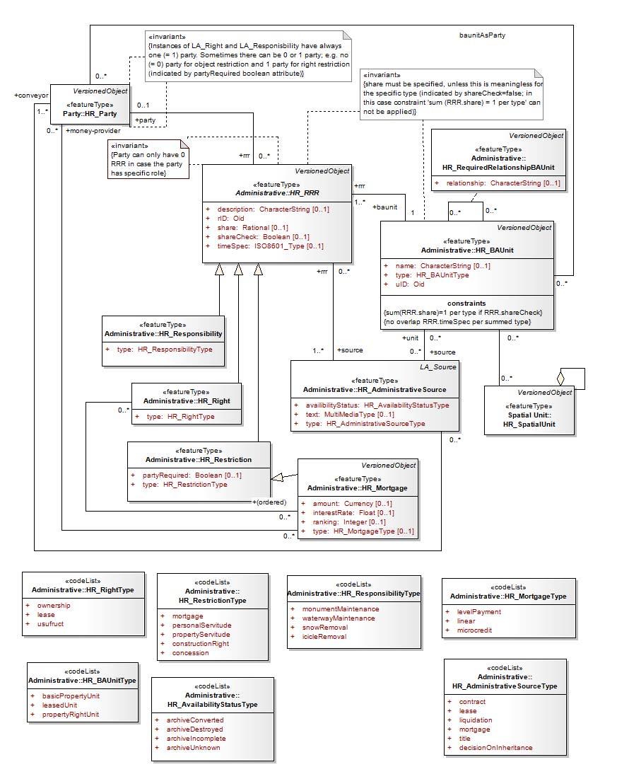
25 Administrative package
26 Spatial unit package The spatial unit package presents the attributes of the land parcels, buildings and other properties associated with land Some attributes related to the cadastral parcel should be added: area, duration of land use, land use type, legality of the building. Two new classes called HR_OldCadastralSurvey and HR_LegalityOfTheBuilding
27 HR_LegalityOfTheBuilding source:
28 HR_OldCadastralSurvey new cadastral survey (not recorded in the land book) old cadastral survey

29 Spatial unit package

30 Spatial unit package (code lists)
31 Conformance testing The abstract test suite is in conformance with ISO The test suite in Annex A of the LADM specifies the requirements that the implementation under test has to meet in order to be conformant to this International Standard. For each test the metadata conformity element takes one of the following values: Conformant (conformant). The resource is fully conformant with the cited specification Not Conformant (notconformant). The resource does not conform to the cited specification Not evaluated (notevaluated). Conformance has not been evaluated.
32 CONCLUSION In conclusion, the adoption of LADM in the Republic of Croatia is possible. Most of LADM classes can apply directly to Croatian Land Administration System (LAS). The types in some code lists have been changed and added to suit to the Croatian LAS. This research proposes two new classes called HR_OldCadastralSurvey and HR_LegalityOfTheBuilding which are solving specifics of the Croatian LAS.

33 Thank you for your atention!
LADM in the Republic of Croatia Making and Testing Country Profile
 Nikola VUČIĆ, Danko MARKOVINOVIĆ and Blaženka MIČEVIĆ, Croatia Key words: LADM, Croatian Cadastre, Land Book, Class, Testing SUMMARY Land Administration Domain Model (LADM) covers basic information related
Topographic Signs Important Context of 3D Cadastre
 STATE GEODETIC ADMINISTRATION Gruška 20,10 000 Zagreb, Croatia Delft University of Technology Faculty of Architecture and the Built Environment Department OTB GIS Technology Section Topographic Signs Important
Cadastral survey - the best way of cadastre modernization Nikola VUČIĆ & Damir ŠANTEK, Croatia
 Presented at the FIG Congress 2018, May 6-11, 2018 in Istanbul, Turkey Cadastral survey - the best way of cadastre modernization Nikola VUČIĆ & Damir ŠANTEK, Croatia LAND ADMINISTRATION IN CROATIA Two
LAND REGISTRATION SYSTEM OF THE REPUBLIC OF CROATIA
 "On the last day of the Creation God desired to crown His work, and thus created Kornati Islands out of tears, stars and breath." (George Bernard Shaw) LAND REGISTRATION SYSTEM OF THE REPUBLIC OF CROATIA
Towards 3D and 4D Cadastre in Croatia
 Nikola VUČIĆ, Miodrag ROIĆ and Danko MARKOVINOVIĆ, Croatia Key words: 3D Cadastre, 4D Cadastre, Croatia, LADM, Utility Cadastre SUMMARY Cadastral systems need to be designed and supported from three dimensional
The Croatian Surveyor Guaranteeing Land Property
 Croatian Chamber of Chartered Geodetic Engineers Zagreb, Croatia www.hkoig.hr The Croatian Surveyor Guaranteeing Land Property Ph. D. Danko Markovinović The Cadastral Surveyor paving the Way to the Future
Towards LADM country cadastral profile case Poland
 Towards LADM country cadastral profile case Poland Jarosław Bydłosz Department of Geomatics Faculty of Mining Surveying and Environmental Engineering International FIG workshop on the Land Administration
Croatian SDI: a Tool for Accelerated Development of the Geo-Conscious Society
 STATE GEODETIC ADMINISTRATION Croatian SDI: a Tool for Accelerated Development of the Geo-Conscious Society Prof.Dr.Sc. Željko Bačić, Mr.Sc. Ljerka Rašić FIG Working Week 2009 - Surveyors Key Role in Accelerated
Country report, HUNGARY
 Country report, HUNGARY Gyula IVÁN Institute of Geodesy, Cartography & Remote Sensing (FÖMI) HUNGARY FIG Commission 7 Annual Meeting 2009 12-16 October, 2009, Kuala Lumpur, Malaysia Institute of Geodesy,
Aspect of preliminary activities in the function of supporting NSDI
 Sonja DIMOVA, Republic of Macedonia Key words: e-governance, geospatial data, NSDI, INSPIRE, metadata SUMMARY The successful establishment of the NSDI in the true sense of the word cannot be performed
DEVELOPMENT OF A STUDY OF IMPLEMENTATION OF THE CADASTRE OF BUILDINGS IN THE REPUBLIC OF CROATIA
 REPUBLIC OF CROATIA Ministry of Construction and Physical Planning State Geodetic Administration Gruška 20, 10000 ZAGREB, CROATIA Phone: +385-1-6165-404 Fax: +385-1-6165-484 Terms of Reference DEVELOPMENT
Transparent Valuation as a Planning Support for Just Land Management System (LMS)
") Hrvoje TOMIĆ, Siniša MASTELIĆ IVIĆ, Miodrag ROIĆ, Croatia Transparent Valuation as a Planning Support for Just Land Management System (LMS) Contents Introduction Land management Real estate valuation The
Hrvoje TOMIĆ, Siniša MASTELIĆ IVIĆ, Miodrag ROIĆ, Croatia Transparent Valuation as a Planning Support for Just Land Management System (LMS) Contents Introduction Land management Real estate valuation The
Implementation Status & Results Croatia Integrated Land Administration System Project (P122219)
") Public Disclosure Authorized Public Disclosure Authorized The World Bank Implementation Status & Results Croatia Integrated Land Administration System Project (P122219) Operation Name: Integrated Land
Public Disclosure Authorized Public Disclosure Authorized The World Bank Implementation Status & Results Croatia Integrated Land Administration System Project (P122219) Operation Name: Integrated Land
Cadastral survey - the best way of cadastre modernization
 Cadastral survey - the best way of cadastre modernization Nikola VUČIĆ, Croatia, Damir ŠANTEK, Croatia Key words: new cadastral survey, land registry, cadastre SUMMARY Different procedures for cadastral
LAND REGISTRATION SYSTEM REFORM
 REPUBLIC OF CROATIA STATE GEODETIC ADMINISTRATION MINISTRY OF JUSTICE LAND REGISTRATION SYSTEM REFORM The Project is funded by the Government of the Republic of Croatia, the World Bank and the European
AREC responsibilities, data and registries and the way of their distribution
 Data as a basis of the digital society PCC, 13-15 March 2018, Sofia AREC responsibilities, data and registries and the way of their distribution Vlatko Dimovski Agency for Real Estate Cadastre (AREC) the
Linking Land Registers and Other Official Registers in the Republic of Croatia based on LADM
 Linking Land Registers and Other Official Registers in the Republic of Croatia based on LADM Mario MAĐER, Hrvoje MATIJEVIĆ and Miodrag ROIĆ, Croatia Key words: official registers, land administration system,
Towards LADM Country Cadastral Profile Case Poland
 Towards LADM Country Cadastral Profile Case Poland Jarosław BYDŁOSZ, Poland Key words: LADM, Country Profile, Cadastre, Poland SUMMARY The Geographic Information - Land Administration Domain Model was
Country Profile for the Cadastre of the Czech Republic Based on LADM
 Country Profile for the Cadastre of the Czech Republic Based on LADM Karel Janečka 1, Petr Souček 2 1 University of West Bohemia, Pilsen, Czech Republic 2 Czech Office for Surveying, Mapping and Cadastre,
LAND CADASTRE AND BUILDING CADASTRE IN SLOVENIA: CURRENT SITUATION AND POTENTIAL OF 3D DATA
 3D Cadastres Organizational and Governmental Aspects LAND CADASTRE AND BUILDING CADASTRE IN SLOVENIA: CURRENT SITUATION AND POTENTIAL OF 3D DATA EMA POGORELČNIK AND MARINA KOROŠEC Surveying and Mapping
Presented at the FIG Working Week 2016, May 2-6, 2016 in Christchurch, New Zealand
 Presented at the FIG Working Week 2016, May 2-6, 2016 in Christchurch, New Zealand The IMPULS Project Is a Project About Cooperation, Coordination, Transparency and Data Sharing A SDI project in the Western
The Challenge to Implement International Cadastral Models Case Finland 1
 The Challenge to Implement International Cadastral Models Case Finland 1 Tarja MYLLYMÄKI and Tarja PYKÄLÄ, Finland Key words: cadastre, modelling, LADM, INSPIRE SUMMARY Efforts are currently made to develop
GEODESY IN THE CADASTRE AND REGISTER REGULARIZATION PROGRAM
 GEODESY IN THE CADASTRE AND REGISTER REGULARIZATION PROGRAM José Francisco Valverde Calderón Kenneth Ovares Sánchez 1 Cadastre and Register Regularization Program (CRRP) Legal base: law 8154 of 2001. Objective:
INTEGRATED LAND ADMINISTRATION SYSTEM PROJECT PREPARATION (IBRD Advance no. P459-HR) TERMS OF REFERENCE
 TERMS OF REFERENCE") INTEGRATED LAND ADMINISTRATION SYSTEM PROJECT PREPARATION (IBRD Advance no. P459-HR) TERMS OF REFERENCE SERVICE PROVISION FOR THE SUPPORT TO THE NATIONAL SPATIAL DATA INFRASTRUCTURE (NSDI) DEVELOPMENT
INTEGRATED LAND ADMINISTRATION SYSTEM PROJECT PREPARATION (IBRD Advance no. P459-HR) TERMS OF REFERENCE SERVICE PROVISION FOR THE SUPPORT TO THE NATIONAL SPATIAL DATA INFRASTRUCTURE (NSDI) DEVELOPMENT
Towards Kenya s Profile of the Land Administration Domain Model
 Department of Geospatial and Space Technology University of Nairobi Towards Kenya s Profile of the Land Administration Domain Model David N. Siriba and Jasper N. Mwenda dnsiriba, jnmwenda{@uonbi.ac.ke}
Serbia Should Have Online Cadastre for Property Like Other Countries in the Region
 Serbia Should Have Online Cadastre for Property Like Other Countries in the Region Tamara Borovcanin USAID Business Enabling Project The online real estate registry allows citizens to quickly and easily
The World Bank Integrated Land Administration System Project (P122219)
") Public Disclosure Authorized EUROPE AND CENTRAL ASIA Croatia Social, Urban, Rural and Resilience Global Practice Global Practice IBRD/IDA Investment Project Financing FY 2012 Seq No: 14 ARCHIVED on 07-Dec-2017
Public Disclosure Authorized EUROPE AND CENTRAL ASIA Croatia Social, Urban, Rural and Resilience Global Practice Global Practice IBRD/IDA Investment Project Financing FY 2012 Seq No: 14 ARCHIVED on 07-Dec-2017
Croatian NSDI - An example of AGISEE country web-page. Vlado Cetl and Miljenko Lapaine
 Croatian NSDI - An example of AGISEE country web-page Vlado Cetl and Miljenko Lapaine Introduction 2/18 Guidelines AGISSE Country Pages should provide an overview of the situation of SDIs in the countries
Quality Improvement of the Real Estate Cadastre in Serbia
 , Serbia Key words: quality improvement, real estate information, quality assurance, Serbia SUMMARY The concept of cadastral modernization in the Republic of Serbia was defined in 1992, and it is being
Implementation Status & Results Croatia Integrated Land Administration System Project (P122219)
") Public Disclosure Authorized Public Disclosure Authorized The World Bank Implementation Status & Results Croatia Integrated Land Administration System Project (P122219) Operation Name: Integrated Land
Public Disclosure Authorized Public Disclosure Authorized The World Bank Implementation Status & Results Croatia Integrated Land Administration System Project (P122219) Operation Name: Integrated Land
REFORM OF LAND CADASTRE IN LITHUANIA
 REFORM OF LAND CADASTRE IN LITHUANIA Romualdas KASPERAVICIUS, Lithuania Key words: ABSTRACT Main aim for every Government is to create legal, financial and organisational circumstances for real property.
Regional Cadastral Study Reforms in the Region
 UNECE WORKING PARTY ON LAND ADMINISTRATION Workshop on the Influence of Land Administration on People and Business Cavtat, Croatia 2-3 October 2008 Regional Cadastral Study Reforms in the Region Miodrag
Overview of Legal and Institutional Aspects of Croatian Cadastre and Possibilities for its Upgrading to 3D
 Overview of Legal and Institutional Aspects of Croatian Cadastre and Possibilities for its Upgrading to 3D Nikola VUČIĆ, Miodrag ROIĆ, Mario MAĐER and Saša VRANIĆ, Croatia Key words: 3D Cadastre, Croatia,
ABSTRACT Land Administration System in Lithuania
 ABSTRACT Land Administration System in Lithuania 1. General introduction to the Lithuanian Land Administration System and State Enterprise Centre of Registers ( shortly SECR) Lithuania has established
Use of data in Ukraine for sustainable economic growth. Oleksandr Maliuk State Service of Ukraine for Geodesy, Cartography and Cadastre
 Use of data in Ukraine for sustainable economic growth Oleksandr Maliuk State Service of Ukraine for Geodesy, Cartography and Cadastre Kehl, 2017 Content of the presentation Ukraine & StateGeoCadastre:
Spatial Representation of Condominium/Co-ownership - Comparison of Quebec and French Cadastral System based on LADM Specifications
 Spatial Representation of Condominium/Co-ownership - Comparison of Quebec and French Cadastral System based on LADM Specifications Dr. Jacynthe POULIOT, a.-g. Marc VASSEUR, Graduate student, INSA, Strasbourg,
Role of Republic Geodetic Authority in the Serbian geo-sector
 Role of Republic Geodetic Authority in the Serbian geo-sector Republic Geodetic Authority, Serbia www.rgz.gov.rs EuroGeographics General Assembly 2014 Moldova, Chisinau, 28 th 30 th September 2014 The
Functional system for cadastral plans
 , Republic of Macedonia Key words: Cadastre, Digital plans, Data, System SUMMARY The analysis shows that the real estate market in Republic of Macedonia grows daily. With the expansion of this market increases
International funding projects in Republic Geodetic Authority
 International funding projects in Republic Geodetic Authority Serbia: Republic Geodetic Authority Workshop Exploring Funding Instruments for NMCA 7-8 November 2012 Republic Geodetic Authority Republic
Economic and Social Council 6 July 2018
 1 ADVANCE UNEDITED VERSION UNITED NATIONS E/C.20/2018/12/Add.1 Economic and Social Council 6 July 2018 Committee of Experts on Global Geospatial Information Management Eighth session New York, 1-3 August
A Complete, Free Solution for Cadastral Map Management
 A Complete, Free Solution for Cadastral Map Management Gyula IVÁN Institute of Geodesy, Cartography & Remote Sensing (FÖMI) HUNGARY FIG Commission 7, Annual Meeting 11-15 September 2008., Verona, ITALY
Establishing Efficient Cadastral Surveying Plan in Accordance with Introducing World Geodetic Reference System in Korea
 Modern Environmental Science and Engineering (ISSN 2333-2581) December 2015, Volume 1, No. 6, pp. 299-303 Doi: 10.15341/mese(2333-2581)/06.01.2015/003 Academic Star Publishing Company, 2015 www.academicstar.us
Country Profile for the Cadastre of the Czech Republic Based on LADM
 Karel JANEČKA and Petr SOUČEK, Czech Republic Key words: Country profile, LADM, GeoInfoStrategy SUMMARY In 2014 the New Civil Code entered into force in the Czech Republic. This Act addresses several aspects
BULGARIAN CADASTRE A GUARANTEE FOR THE OWNERSHIP RIGHTS IN IMMOVABLE PROPERTIES
 4 TH INTERNATIONAL CONFERENCE RECENT PROBLEMS IN GEODESY AND RELATED FIELDS WITH INTERNATIONAL IMPORTANCE February 28 - March 2, 2007, Inter Expo Centre, Sofia, Bulgaria BULGARIAN CADASTRE A GUARANTEE
Development of Cadastral Metadata Service (Cadastral Metadata Database)
") Development of Cadastral Metadata Service (Cadastral Metadata Database) Vlado CETL, Miodrag ROIĆ and Mario MAĐER, Croatia Key words: cadastre, metadata, database, Web services SUMMARY Cadastre as the large-scale
Development of Cadastral Metadata Service (Cadastral Metadata Database) Vlado CETL, Miodrag ROIĆ and Mario MAĐER, Croatia Key words: cadastre, metadata, database, Web services SUMMARY Cadastre as the large-scale
Linking the Land Information Systems in the Philippines Using the LADM as a Global Schema
 Linking the Land Information Systems in the Philippines Using the LADM as a Global Schema Romer Kristi ARANAS, Rhodora GONZALEZ and Louie Balicanta, Philippines Key words: Digital cadastre, e-governance,
Designing for transparency and participation in the Hellenic Cadastral Project
 Designing for transparency and participation in the Hellenic Cadastral Project Dr. Dimitris Rokos Director of Planning and Investments, Hellenic National Cadastre and Mapping Agency S.A. Table of Contents
The Boundary and the Effects of Cadastral Surveying in Cyprus
 The Boundary and the Effects of Cadastral Surveying in Cyprus Aristi Louca, Margarita Fani Surveyor Engineers, Cyprus Association of Rural and Surveying Engineers The History of Cyprus goes back 11000
Republic of Bulgaria
 Geodesy, Cartography and Cadastre Agency Republic of Bulgaria www.cadastre.bg 24. 01. 2018 г., гр. София The Cadastre Legislation in Bulgaria - historical reference 1908 г. The Cadastre Act The objective
Hungarian Cadastre and its relation to LADM
 Hungarian Cadastre and its relation to LADM Gyula IVÁN CLGE General Assembly 22 March 2013, Budapest, HUNGARY Content Historical background Evolution of Cadastral modeling in Hungary LADM issues Conclusion
e-cadastre and Photo-Interpretation Technologies
 UNECE- WPLA EFFICIENT AND TRANSPARENT LAND MANAGEMENT IN ECE COUNTRIES 4 March 2010 - Baku, Azerbaijan e-cadastre and Photo-Interpretation Technologies The Italian experience as an example of Good Practice
Preprint.
 http://www.diva-portal.org Preprint This is the submitted version of a paper presented at 10th EC GI & GIS Workshop, ESDI State of the Art, Warsaw, Poland, 23-25 June 2004. Citation for the original published
Cadastral Parcels in the context of INSPIRE
 Cadastral Parcels in the context of INSPIRE Gyula IVÁN Institute of Geodesy, Cartography & Remote Sensing, HUNGARY Open Symposium on Environment and Land Administration Big Works for the Defence of Territory
Spatial Data Infrastructure in Sweden
 Spatial Data Infrastructure in Sweden Hans-Erik WIBERG, Sweden Key words: ABSTRACT Sweden was one of the first countries to address Data Infrastructure matters and have during several decades developed
FIG Congress 2010 Facing the Challenges Building the Capacity Sydney, Australia, April
 Setting up the infrastructure for improving the development of Cadastre in Greece Dr. Dimitris ROKOS, Dr. Konstantinos KYRIAZIS and Dr. Panos LOLONIS KTIMATOLOGIO S.A. (Hellenic Cadastre) Source: wikipedia
NEW DEVELOPMENTS IN THE REAL PROPERTY REGISTER AND CADASTRE IN LITHUANIA
 NEW DEVELOPMENTS IN THE REAL PROPERTY REGISTER AND CADASTRE IN LITHUANIA Jaunius Grigas E-mail: jaunius.grigas@registrucentras.lt Verona, 2008 FUNCTIONS OF STATE ENTERPRISE CENTRE OF REGISTERS Registration
DATR towards e-land Administration in Hungary
 DATR towards e-land Administration in Hungary Gyula IVÁN-Gábor SZABÓ-Zoltán WENINGER-Piroska Zalaba Institute of Geodesy, Cartography and Remote Sensing, Budapest, HUNGARY XXIV. FIG Congress Facing the
The Contribution of Forest Owners Associations for the Forest Cadastre Implementation. João Gaspar Ana Navarro Ferreira PORTUGAL
 The Contribution of Forest Owners Associations for the Forest Cadastre Implementation João Gaspar Ana Navarro Ferreira PORTUGAL Motivation Lack of forestry cadastre; Unify all FOAs databases with common
Development of 3D Cadastre in Hungary
 Development of 3D Cadastre in Hungary András OSSKÓ Gyula IVÁN CLGE General Assembly 22 March 2013, Budapest, HUNGARY Content Introduction Problems in development of 3D cadastre and registration Hungarian
Quality Improvement to Cadastral Information in Sweden
 Gunnar BLIXT, Sweden Key words: digital cadastre, quality, cadastral index map, real property register. SUMMARY Lantmäteriet is a governmental agency which gives support for creating an efficient and sustainable
LIS a motivation for SDI initiative
 Eric Mwaikambo Ardhi University Dar es Salaam Tanzania Overview Status of LIS in Tanzania Relationship between SDI and LIS Spatial Standards LIS a motivation for SDI initiative Conclusion & Recommendations
Cadastral services and virtual office in e-cadastre
 Cadastral services and virtual office in e-cadastre Priit Kuus Estonian Land Board October 26, 2016 Coimbra Scope of data Cadastral parcels (as of September 2016) 674 383 cadastral parcels, i.e. 97,7 %
Role of spatial planning in modern society
 Republic of Croatia State Geodetic Administration The Role of Cadastre in the Development of Regional and Local Planning Structure in Croatia Zdravko Cesarec and Željko Bačić 1 Role of spatial planning
Presented by: Stewart Information International, Inc. Jack McKenna
 Presented by: Stewart Information International, Inc. Jack McKenna Held at the: 2007 ESRI Survey & Engineering GIS Summit San Diego Convention Center San Diego, California June 16-19, 2007 Integrating
Land Information Management in Southern Africa Focus on technology management training in Surveying and Mapping in Namibia
 Land Information Management in Southern Africa Focus on technology management training in Surveying and Mapping in Namibia Chris Paresi, Urban and Regional Planning and Geo-Information Management Department,
Ownership Data in Cadastral Information System of Sofia (CIS Sofia) from the Available Cadastral Map
 from the Available Cadastral Map") Ownership Data in Cadastral Information System of Sofia (CIS Sofia) from the Available Cadastral Map Key words: ABSTRACT Lydmila LAZAROVA, Bulgaria CIS Sofia is created and maintained by GIS Sofia ltd,
Ownership Data in Cadastral Information System of Sofia (CIS Sofia) from the Available Cadastral Map Key words: ABSTRACT Lydmila LAZAROVA, Bulgaria CIS Sofia is created and maintained by GIS Sofia ltd,
Land Governance Monitoring
 University of Zagreb Faculty of Geodesy Land Governance Monitoring Proposal for pilot implementation in Croatia Final report Deliverable 4 7 June 2016 Contents Executive summary... 4 1 Introduction...
Land Cadastre Act. Chapter 1. Passed RT I 1994, 74, 1324 Entry into force (except 3 which entered into force on 1.01.
 Issuer: Riigikogu Type: act In force from: 01.01.2011 In force until: 31.12.2014 Translation published: 24.10.2014 Passed 12.10.1994 RT I 1994, 74, 1324 Entry into force 08.11.1994 (except 3 which entered
Urban-Rural Interrelationship for Sustainable Environment
 Urban-Rural Interrelationship for Sustainable Environment Marrakech 2-52 5 December 2003 Department of Lands and Survey - The Modernization Journey A Paper presented by Eng. Sameer Abbadi Surveying and
Challenge to Implement International Cadastral Models Case Finland
 FIG Articleof the Month April 20 Challenge to Implement International Cadastral Models Case Finland Tarja Myllymäki and Tarja Pykälä 200-04-5 The topics are In European level INSPIRE Experiences, similarities,
GEOSPATIAL INFORMATION MANAGMENT IN CROATIA: REPORT 2012
 REPUBLIC OF CROATIA State Geodetic Administration GEOSPATIAL INFORMATION MANAGMENT IN CROATIA: REPORT 2012 Document submited by: Tomislav Ciceli 1 Abstract This report is dealing with current situation
Improvement of Effectiveness Present Developments in Hungarian Land Administration
 Improvement of Effectiveness Present Developments in Hungarian Land Administration Gyula IVÁN and András OSSKÓ, Hungary Key words: Land Administration, Cadastre, Land Registry SUMMARY New Act on Surveying
LADM-based Crowdsourced 3D Cadastral Surveying Potential and Perspectives
 National Technical University Of Athens School of Rural and Surveying Engineering LADM-based Crowdsourced 3D Cadastral Surveying Potential and Perspectives Maria Gkeli, Surveying Engineer, PhD student
VIROVITICA ON CADASTRAL MAPS
 CO-295 VIROVITICA ON CADASTRAL MAPS KICINBACI S. State geodetic administration, VIROVITICA, CROATIA Virovitica is a town in northern Croatia with a population of 15,000. The town is situated in the valley
The Role of National Mapping and Cadastre Agencies in Establishment of NSDI: Croatian Example
 The Role of National Mapping and Cadastre Agencies in Establishment of NSDI: Croatian Example Ljerka RAŠIĆ and Željko BAČIĆ, Croatia Key words: spatial data infrastructure, NSDI, NMCA, Inspire SUMMARY
FEES AND CHARGES IN CROATIAN LAND ADMINISTRATION
 REPUBLIC OF CROATIA STATE GEODETIC ADMINISTRATION DGU FEES AND CHARGES IN CROATIAN LAND ADMINISTRATION Prof.dr.sc.Željko Bačić Director general UN ECE WPLA Sixth Session Geneva, June, 18-19, 2009 1 ORGANIZATIONAL
Unified Land Administration for a Better Spatial Infrastructure
 Unified Land Administration for a Better Spatial Infrastructure Gyula IVÁN Institute of Geodesy, Cartography & Remote Sensing FÖMI (HUNGARY) Open Symposium 30th Korean Cadastral Seminar & FIG Commission
Bruna Horović-Vuković Split, 15 September 2011
 Bruna Horović-Vuković Split, 15 September 2011 Archive of Maps for Istria and Dalmatia 1834 Archive of Maps for Dalmatia was founded in Zadar 1924 the material moves to Split into the Archive of the Maps
STATE COMMITTEE OF THE REPUBLIC OF UZBEKISTAN ON LAND RESOURCES, GEODESIES, TO CARTOGRAPHY AND STATE INVENTORY
 STATE COMMITTEE OF THE REPUBLIC OF UZBEKISTAN ON LAND RESOURCES, GEODESIES, TO CARTOGRAPHY AND STATE INVENTORY Development of services in providing information on land resources and real estate, introduction
The Multi-Purpose Information System of Real Estates in the Czech Republic. Vladimíra ŽUFANOVÁ, Czech Republic
 The Multi-Purpose Information System of Real Estates in the Czech Republic Vladimíra ŽUFANOVÁ, Czech Republic Key words: Cadastre; Land management SUMMARY The Cadastre of Real Estate and Land administration,
Cadastral Information System of Sofia
 Alexander LAZAROV and Hristo DECHEV, Bulgaria Key words: ABSTRACT A new Cadastre and Property Register Act (CPRA) was passed in April 2000, setting up rules for the maintenance of these two registers.
Procedures for the legalization and registration of buildings and building units Challenges and Problems Building cadastre in Slovenia
 Procedures for the legalization and registration of buildings and building units Challenges and Problems Building cadastre in Slovenia Edvard Mivšek M.Sc. Geodetic institut of Slovenija Pristina, 19 April
Cadastre: definitions
 Introduction New vision towards a multipurpose cadastral system to support land management in Morocco Moha EL-AYACHI, El Hassane SEMLALI, Mohamed ETTARID, Driss TAHIRI, Institut Agronomique et Vétérinaire
Annual Report Of the Czech Office for Surveying, Mapping and Cadastre For 2016
 Annual Report Of the Czech Office for Surveying, Mapping and Cadastre For 2016 Prague, 2017 1 CONTENT Introduction 1. Surveying, Mapping and Cadastre Sector in the Czech Republic 2. Administration of the
National Spatial Data Infrastructure development in Republic of Macedonia
 National Spatial Data Infrastructure development in Republic of Macedonia Sonja Dimova, state advisor for geomatics AGENCY FOR REAL ESTATE CADASTRE September 6-th, 2017, Strasbourg AREC competence for
PROJECT INFORMATION DOCUMENT (PID) APPRAISAL STAGE Report No.: PIDA Project Name. Region Country Sector(s) Theme(s)
 APPRAISAL STAGE Report No.: PIDA Project Name. Region Country Sector(s) Theme(s)") Public Disclosure Authorized Public Disclosure Authorized Public Disclosure Authorized Public Disclosure Authorized Project Name Region Country Sector(s) Theme(s) Lending Instrument Project ID Borrower(s)
Public Disclosure Authorized Public Disclosure Authorized Public Disclosure Authorized Public Disclosure Authorized Project Name Region Country Sector(s) Theme(s) Lending Instrument Project ID Borrower(s)
Building Integrated Land Information Systems and Development of NSDI
 Stig JÖNSSON, Sweden Key words: Land administration, land information systems, property formation, spatial data infrastructure, Inspire, institutional cooperation SUMMARY Lantmäteriet the Swedish agency
Cadastral Survey in the Process of Modernization and Actualization of the Croatian Cadastre System and it`s Adjusting with Land Management Register
 Cadastral Survey in the Process of Modernization and Actualization of the Croatian Cadastre System and it`s Adjusting with Land Management Register Vedran CAR, Jelena CAR and Dino DRAGUN, Croatia Key words:
INTERNATIONAL JOURNAL OF GEOMATICS AND GEOSCIENCES Volume 2, No 2, 2011
 INTERNATIONAL JOURNAL OF GEOMATICS AND GEOSCIENCES Volume 2, No 2, 2011 Copyright 2010 All rights reserved Integrated Publishing services Case study ISSN 0976 4380 Property formation-change in land related
Cadastral Parcels in INSPIRE. Lisbon, 27 February 2013
 Cadastral Parcels in INSPIRE Lisbon, 27 February 2013 Dominique.laurent@ign.fr Plan INSPIRE context The modeling approach for theme Cadastral Parcels Implementation of INSPIRE theme Cadastral Parcels Context
LAND ADMINISTRATION IN LITHUANIA: CHALLENGES AND PERSPECTIVES
 UNECE WPLA Workshop Influence of Land Administration on People and Business, Cavtat, Croatia, October 2-3, 2008 LAND ADMINISTRATION IN LITHUANIA: CHALLENGES AND PERSPECTIVES Kestutis Sabaliauskas, Director
COMPUTERIZED SYSTEM SUPPORTING DEVELOPMENT OF LAND MARKET IN GEORGIA
 COMPUTERIZED SYSTEM SUPPORTING DEVELOPMENT OF LAND MARKET IN GEORGIA S. G. TSIRAMUA, I. S. MELASHVILI Land Registration Unit of Government of Georgian, World Bank and IFAD Agriculture Development Project.
NATIONAL REPORT REPUBLIC OF MACEDONIA
 NATIONAL REPORT REPUBLIC OF MACEDONIA AGENCY FOR REAL ESTATE CADASTRE Department for Geodetic Works Sasho Dimeski, Brankica Stojanovska, Srechko Tasevski REVIEW OF AREC National Cadastral and Mapping Agency
INSPIRE implementation as a link between egovernment and environmental purposes
 INSPIRE implementation as a link between egovernment and environmental purposes Jiří Poláček Czech Office for Surveying, Mapping and Cadastre (ČÚZK) What s to Come Role of ČÚZK branch in the INSPIRE implementation.
Section I General Information
 General Information Table of Contents A. Introduction... I-2 1. Purpose... I-2 2. Scope... I-2 3. Maintenance... I-3 4. Units... I-3 B. Public Relations... I-3 1. General Public... I-3 2. Property Owners...
Mass Valuation and Sales Price Register in the Republic of Serbia
 REPUBLIC OF SERBIA REPUBLIC GEODETIC AUTHORITY Mass Valuation and Sales Price Register in the Republic of Serbia Department for Mass Valuation Head of Department: Marija Raskovic procena@rgz.gov.rs Soest,
Test and Implementation of DATR System in Hungary
 Test and Implementation of DATR System in Hungary, Hungary Key words: unified land registry, cadastral map, Hungary SUMMARY During the last years there has been an important development in the Hungarian
Cadastral Framework Standards
 Cadastral Framework Standards The goal of the Data Standards and Recommendations Committee is to provide recommendations and guidelines to Indiana GIS user communities to facilitate the collection, maintenance
The Role of Geodesy in Modernization of Croatian Railways
 Igor POLJANAC, Rinaldo PAAR and Vlado CETL, Croatia Key words: railways, modernization, infrastructure, and geodesy. SUMMARY At the beginning of the 90-s in the last century the changes in the economic
Object Oriented Unified Real Estate Registry for a Good Spatial Data Management
 Object Oriented Unified Real Estate Registry for a Good Spatial Data Management Gyula IVÁN Gábor SZABÓ Zoltán WENINGER Institute of Geodesy, Cartography and Remote Sensing (FÖMI), Hungary Workshop on e-governance,