Request for Rezoning. Current Zoning: Proposed Zoning:
|
|
|
- Alisha Dean
- 5 years ago
- Views:
Transcription
1 TO: Denver City Council, Neighborhoods and Planning Committee FROM: Theresa Lucero, Senior City Planner DATE: March 31, 2016 RE: Zoning Map Amendment #2015I Rezoning from M-RX-5 to I-MX-3 Community Planning and Development Planning Services 201 W. Colfax Ave., Dept. 205 Denver, CO p: f: Staff Report and Recommendation Based on the criteria for review in the Denver Zoning Code, Staff recommends approval for Application #2015I for a rezoning from M-RX-5 to I-MX-3. Request for Rezoning Application: #2015I Address: Neighborhood/Council District: Stapleton Statistical Neighborhood / City Council District #8 RNOs: Northern Airport Corridor Association, Stapleton Master Community Association, Stapleton United Neighbors and. Inter-Neighborhood Cooperation Area of Property: 24,269 Square Feet, 0.56 acres Current Zoning: M-RX-5 Proposed Zoning: I-MX-3 Property Owner(s): Park Creek Metropolitan District Owner Representative: Bruce O Donnell Summary of Rezoning Request The subject property is vacant and is located at the northeast corner of future Dallas Street and 51 st Avenue. (This intersection is not constructed, though the intersection has been engineered in an adopted subdivision, Stapleton Filing Number 47, resolution number ). The applicant proposes to use the property as a maintenance facility for north Stapleton local and regional open space. This is not an allowed use in the current M-RX-5 zone district because of the need for outdoor storage. The proposed I-MX-3 zone district stands for Industrial Context, Mixed Use with a 3-story height limit. The I-MX-3 zone district is intended to promote pedestrian-oriented areas that activate the street level while providing a transition between mixed use areas and industrial areas. The I- MX-3 zone district occurs in areas served primarily by collector streets where a height limit of 3 stories is desired. Further details of the zone districts can be found in Article 9 of the Denver Zoning Code (DZC).


2 Rezoning Application #2015I March 31, 2016 Page - 2 -
 by industrial land uses, mainly in the form of 1-2-story warehouses.")
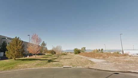
3 Rezoning Application #2015I March 31, 2016 Page Existing Context The property is located in the northeast portion of the Stapleton neighborhood, north of Interstate 70, south of 56 th Avenue, between Havana Street and Central Park Boulevard. The property is surrounded on three sides (east, south and southwest) by industrial land uses, mainly in the form of 1-2-story warehouses. The area immediately west of the property, across future Dallas Street, is planned for open space that lines a residential subdivision and Northfield High School is located to the northeast. In the general vicinity are the Rocky Mountain Arsenal to the far northeast, Dicks Sporting Goods Park to the far northwest and the Shops at Northfield Stapleton to the far southwest of the property. The surrounding block pattern is a mix of a grid and modified grid pattern with varied lot sizes tied to the industrial or residential land uses.
4 Rezoning Application #2015I March 31, 2016 Page The following table summarizes the existing context proximate to the subject site: Existing Zoning Existing Land Use Site M-RX-5 Vacant N/A Existing Building Form/Scale North M-RX-5 Industrial 1-2 story warehouse South C-MU-30 with waivers/uo-1 and M-IMX-5 Industrial 1-2 story warehouse East I-2/UO-2 Industrial 1-2 story warehouse West M-RX-5 Vacant N/A Existing Block, Lot, Street Pattern Generally regular grid or modified grid street patterns. Large industrial block sizes and shapes are consistent and rectangular, and smaller residential blocks vary in size with the modified street grid pattern.

5 Rezoning Application #2015I March 31, 2016 Page Existing Zoning The existing zoning of the subject property is M-RX-5, or Master Planned context, Residential Mixed Use district with a 5-story height limit. The low-density residential building forms in this district are allowed a maximum eight of 42 feet, and the commercial/mixed use buildings are allowed a maximum height of 70 feet. A variety of residential and civic land uses are allowed, but commercial, industrial and agricultural land use allowances are more limited. For additional details of the zone district, see DZC Section 9.

6 Rezoning Application #2015I March 31, 2016 Page Existing Land Use Map Existing Land Use

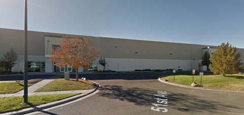
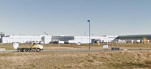
7 Rezoning Application #2015I March 31, 2016 Page Existing Building Form and Scale
8 Rezoning Application #2015I March 31, 2016 Page Summary of City Agency Referral Comments As part of the DZC review process, the rezoning application is referred to potentially affected City agencies and departments for comment. A summary of agency referral responses follows: Asset Management: Approved, no comments. Environmental Health: Approved with the following comments. General Notes: Most of Colorado is high risk for radon, a naturally occurring radioactive gas. Due to concern for potential radon gas intrusion into buildings, DEH suggests installation of a radon mitigation system in structures planned for human occupation or frequent use. It may be more cost effective to install a radon system during new construction rather than after construction is complete. Scope & Limitations: DEH performed a limited search for information known to DEH regarding environmental conditions at the subject site. This review was not intended to conform to ASTM standard practice for Phase I site assessments, nor was it designed to identify all potential environmental conditions. In addition, the review was not intended to assess environmental conditions for any potential right-of-way or easement conveyance process. The City and County of Denver provides no representations or warranties regarding the accuracy, reliability, or completeness of the information provided. Public Works City Surveyor: Approved, no comments. Parks and Recreation: Approved Public Review Process Informational Notice CPD staff provided informational notice of receipt of the rezoning application to affected members of City Council and Registered Neighborhood Organizations on November 21, Planning Board The property was legally posted for a period of 15 days announcing the March , Denver Planning Board public hearing, and written notification of the hearing was sent to all affected registered neighborhood organizations and City Council members. At the meeting the Planning Board voted unanimously to recommend approval of the rezoning application. Neighborhoods and Planning Committee Following Planning Board review the rezoning application will be referred to the Neighborhoods and Planning (PLAN) Committee of the City Council for review at a public meeting. The PLAN Committee meeting is tentatively scheduled for April 6, Electronic notice of the meeting will be sent to all affected Registered Neighborhood Organizations 10 days in advance of the meeting. At the meeting Committee members will vote on whether to move the application forward to a public hearing before the full City Council. City Council Following PLAN Committee review, the rezoning application is typically referred to the full City Council for final action at a public hearing. The City Council public hearing is tentatively scheduled for May 16, Electronic notice of the public hearing will be sent to all
9 Rezoning Application #2015I March 31, 2016 Page affected Registered Neighborhood Associations and notification signs will be posted on the property 21 days in advance of the hearing. Registered Neighborhood Organizations (RNOs) To date, CPD has received no comment letter from a Registered Neighborhood Organization. Other Public Comment To date, no other public comments have been received. Criteria for Review / Staff Evaluation The criteria for review of this rezoning application are found in DZC, Sections and , as follows: DZC Section Consistency with Adopted Plans 2. Uniformity of District Regulations and Restrictions 3. Public Health, Safety and General Welfare DZC Section Justifying Circumstances 2. Consistency with Neighborhood Context Description, Zone District Purpose and Intent Statements 1. Consistency with Adopted Plans The following adopted plans apply to this property: Denver Comprehensive Plan 2000 Blueprint Denver (2002) Stapleton Development Plan (1995) North Stapleton General Development Plan, Major Amendment No.2 (2012) Denver Comprehensive Plan 2000 The proposal is consistent with many Denver Comprehensive Plan strategies, including: Environmental Sustainability Strategy 4-C Respect, conserve and expand wildlife habitat, watersheds, open space and other natural resources when planning, designing and building new projects (P. 41). Land Use Strategy 3-B Encourage quality infill development that is consistent with the character of the surrounding neighborhood; that offers opportunities for increased density and more amenities; and that broadens the variety of compatible uses (p. 60). Legacies Strategy 9-B Integrate sufficient open space and recreational amenities, including small urban parks, into large-scale development plans (p. 102). The proposed map amendment will allow the development of a maintenance facility to service open space in North Stapleton. This facility contributes to the provision of the open space and to the quality of Stapleton development. The proposed I-MX-3 zone district allows a wide variety of residential, civic, commercial and limited industrial lands uses. The rezoning is consistent with these plan recommendations.
10 Rezoning Application #2015I March 31, 2016 Page Blueprint Denver The Blueprint Denver future land use designation for the subject property is Park and the property is in an Area of Change. The Blueprint Denver future street classifications identified near the subject property are Undesignated Local Streets. Blueprint Denver describes Parks and Open Space as public spaces ranging from historic traditional parks to natural areas along the waterways. They provide a welcome respite from the intensity of urban living. Parks and open spaces range from active neighborhood and community parks and recreation fields and centers to larger preserves of natural open areas that provide space for wildlife habitat (p. 40). The purpose of Areas of Change is to channel growth where it will be beneficial and can best improve access to jobs, housing and services with fewer and shorter auto trips (p. 127). The rezoning of the subject property will enable the continued redevelopment of the former Stapleton Airport into a new residential mixed use neighborhood which provides the envisioned jobs, housing and services, including parks and open space. In the Stapleton area Blueprint Denver applied broad land use categories before the area was platted. Due to the existing alignment of the streets to be constructed, the property east of Dallas Street, and this remnant parcel, are more appropriately treated like the industrial parcels to the east. These parcels have single family residential and employment designation on the Blueprint Map but as Stapleton developed, and more specific General Development Plans were approved, the parcels have been zoned and developed as industrial. The I-MX-3 zone district will allow the property to be used either for the outdoor storage needed in the maintenance facility for the regional and local open space or for open space. It also allows for the property to be used as a transition between the existing industrial and uses east of Dallas Street and the regional open space and residential development west of Dallas Street. If the proposed land use were located on the west side of Dallas Street it would be approved as an accessory use to the regional open space. Because the property is separated into a separate zone lot the rezoning is necessary. Staff believes that because the I-MX-3 zone district allows open space it is consistent with the Blueprint land use designation of Park.

11 Rezoning Application #2015I March 31, 2016 Page Blueprint Denver Future Land Use Map Stapleton Development Plan (1995) The applicable neighborhood plan for the property is the Stapleton Development Plan, which was adopted in March, On the Development Plan map the subject property is in District V. The District is bounded by 56 th Avenue on the north, Interstate 70 on the south, Havana Street on the east and a major drainageway and open space on the west. Key elements of the Development Plan for this area are a predominance of employment land uses including manufacturing, assembly, distribution, office and research and development; a district commercial center serving employees; transportation improvements, and drainage corridors serving as public parks with trails, landscape buffering and habitat (p. 5-56). The proposed I-MX-3 zone district is consistent with this Plan vision and will provide the regulatory basis for the maintenance facility for the area open space.

12 Rezoning Application #2015I March 31, 2016 Page District V - Stapleton Development Plan Map
13 Rezoning Application #2015I March 31, 2016 Page North Stapleton General Development Plan The North Stapleton General Development Plan (GDP) approved in 2012 designates the subject property as In-Tract Open Space. The In-Tract Open Space land use category in the North Stapleton General Development Plan is envisioned as useable parks and open space to serve local Stapleton residents as development occurs. On the GDP land use map In-Tract Open Space on the subject property is across future Dallas Street from the regional (Trunk) open space. On the map the anticipated zone district is M-RX-5, the existing zone district. Staff believes the M-RX-5 zone district was anticipated because the district does allow open space land uses. The notes on the GDP proposed land use sheet also state that the In-Tract open space on the subject property will not be specifically programmed until the subdivision process. On the Filing Number 47 recorded subdivision plat it states that the subject property will be owned and maintained by the Park Creek Metropolitan District. In the process of specifically programming the In- Tract open space on the subject property, the District identified the subject property as a good location for a maintenance yard to serve both the In-Tract and Trunk open space in north Stapleton. In subsequent discussions with CPD zoning staff it was determined that the existing M-RX-5 zone district does not allow the outdoor storage needed to establish a maintenance facility as a primary use on the property, and the I-MX-3 zone district is a district that would allow both the open space use and the outdoor storage needed for a maintenance facility. The General Development Plan also established a hierarchy of street types for the north Stapleton area. On the GDP Roadway Design Criteria sheet it states that both Dallas and 51 st Avenue are collector streets. Because the subject property is located on collector streets, is located adjacent to existing industrial land uses, the proposed I-MX-3 zone district allows both the open space land use and a land use that allows outdoor storage and the establishment of the maintenance yard on the subject property will serve the area regional open space, staff believes the I-MX-3 zone district is consistent with this planned land use concept in the GDP.

14 Rezoning Application #2015I March 31, 2016 Page North Stapleton GDP Land Use Map
15 Rezoning Application #2015I March 31, 2016 Page Uniformity of District Regulations and Restrictions The proposed rezoning to I-MX-3 will result in the uniform application of zone district building form, use and design regulations. 3. Public Health, Safety and General Welfare The proposed official map amendment furthers the public health, safety, and general welfare of the City. 4. Justifying Circumstance The application identifies the changing condition of the redevelopment of the Stapleton area as the Justifying Circumstance under DZC Section , The land or its surrounding environs has changed or is changing to such a degree that it is in the public interest to encourage a redevelopment of the area or to recognize the changed character of the area. The ongoing redevelopment of north Stapleton, the completion of major regional infrastructure improvements, and the development of additional residential dwelling units needing quality parks and open space are cited by the applicant as the justifying circumstance. Staff concurs that these are appropriate justifying circumstances for the proposed rezoning. 5. Consistency with Neighborhood Context Description, Zone District Purpose and Intent Statements A Denver Zoning Code criterion is that the proposed official map amendment should be consistent with the descriptions of the applicable neighborhood context, and with the stated purpose and intent of the proposed zone district. The Industrial Context consists of areas of light industrial, warehouse and heavy industrial areas, as well as areas subject to transitions from industrial to mixed-use. The Industrial Context includes parts of the city where outdoor uses and activities are accommodated, with appropriate screening, including outdoor storage, heavy commercial services, and waste services. Building forms are often tall single-story buildings or multi-story buildings with tall ceilings that accommodate industrial processes, loading bays, and specialized equipment. The Industrial Context consists of an irregular pattern of large blocks. Vehicle access is typically a drive from the street to a surface parking lot. Truck access, loading, and parking are important attributes. The Industrial Mixed Use Districts have a more urban context with a rectangular street grid and alley access. Industrial buildings are typically placed to accommodate the specific activity, often with parking surrounding the building. In many cases, the Industrial Context incorporates existing buildings with raised loading docks presenting particular access and parking challenges. Building placement in the Industrial Mixed Use districts is closer to the street with parking, loading and access in the rear of the site. Building heights range from 1-8 stories which utilize simple forms to maximize open floor space to accommodate warehousing, although older industrial areas include multi-story warehouse buildings, manufacturing uses, adaptive re-use of industrial structures, and multi-storied mixed use buildings. The Industrial Context has typically had a relatively low level of access to the multi-modal transit system, although many areas are adjacent to transitioning Areas of Change associated with new or existing rail transit lines.
16 Rezoning Application #2015I March 31, 2016 Page The purpose and intent of the I-MX-3 zone district is to promote development of a pedestrian-oriented pattern, with buildings built up to the street and an active Street Level. The Industrial Mixed Use districts are also intended to provide a transition between mixed use areas and Industrial Districts. Land use in the district area a variety of industrial, commercial civic and residential uses. The proposed I-MX-3 zone district applies to areas served primarily by local or collector streets with a maximum building height of 3 stories. The subject property is located at the intersection of two collector streets and is adjacent to existing established industrial land uses. The I-MX-3 zone district could serve as a transition between the existing industrial land uses east of Dallas Street and the regional open space located west of Dallas Street. Staff believes the proposed the I-MX-3 zone district is consistent with the existing adjacent industrial land uses, and with the intent of the Industrial Context and with the I-MX-3 zone district to serve as a transition between a mixture of land uses. Staff Recommendation Based on the analysis set forth above, CPD staff finds that the application for rezoning the property located at to an I-MX-3 zone district meets the requisite review criteria. Accordingly, staff recommends approval. Attachments 1. Application 2. Approved Legal Description
17 Zone Map Amendment (Rezoning) - Application COMMUNITY PLANNING & DEVELOPMENT REZONING GUIDE Rezoning Application Page 1 of 3 PROPERTY OWNER INFORMATION* CHECK IF POINT OF CONTACT FOR APPLICATION Property Owner Name Address City, State, Zip Telephone *If More Than One Property Owner: All standard zone map amendment applications shall be initiated by all the owners of at least 51% of the total area of the zone lots subject to the rezoning application, or their representatives authorized in writing to do so. See page 3. PROPERTY OWNER(S) REPRESENTATIVE** CHECK IF POINT OF CONTACT FOR APPLICATION Representative Name Address City, State, Zip Telephone **Property owner shall provide a written letter authorizing the representative to act on his/her behalf. Please attach Proof of Ownership acceptable to the Manager for each property owner signing the application, such as (a) Assessor s Record, (b) Warranty deed or deed of trust, or (c) Title policy or commitment dated no earlier than 60 days prior to application date. SUBJECT PROPERTY INFORMATION Location (address and/or boundary description): Assessor s Parcel Numbers: Area in Acres or Square Feet: Current Zone District(s): PROPOSAL Proposed Zone District: Does the proposal comply with the minimum area requirements specified in DZC Sec : Yes No Last updated: February 4, 2015 Return completed form to rezoning@denvergov.org 201 W. Colfax Ave., Dept. 205 Denver, CO rezoning@denvergov.org 2015I November 19th 2015, Fees pd CC $1000


18 COMMUNITY PLANNING & DEVELOPMENT REZONING GUIDE Rezoning Application Page 2 of 3 REVIEW CRITERIA General Review Criteria: The proposal must comply with all of the general review criteria DZC Sec Additional Review Criteria for Non-Legislative Rezonings: The proposal must comply with both of the additional review criteria DZC Sec Consistency with Adopted Plans: The proposed official map amendment is consistent with the City s adopted plans, or the proposed rezoning is necessary to provide land for a community need that was not anticipated at the time of adoption of the City s Plan. Please provide an attachment describing relevant adopted plans and how proposed map amendment is consistent with those plan recommendations; or, describe how the map amendment is necessary to provide for an unanticipated community need. Uniformity of District Regulations and Restrictions: The proposed official map amendment results in regulations and restrictions that are uniform for each kind of building throughout each district having the same classification and bearing the same symbol or designation on the official map, but the regulations in one district may differ from those in other districts. Public Health, Safety and General Welfare: The proposed official map amendment furthers the public health, safety, and general welfare of the City. Justifying Circumstances - One of the following circumstances exists: The existing zoning of the land was the result of an error. The existing zoning of the land was based on a mistake of fact. The existing zoning of the land failed to take into account the constraints on development created by the natural characteristics of the land, including, but not limited to, steep slopes, floodplain, unstable soils, and inadequate drainage. The land or its surroundings has changed or is changing to such a degree that it is in the public interest to encourage a redevelopment of the area to recognize the changed character of the area. It is in the public interest to encourage a departure from the existing zoning through application of supplemental zoning regulations that are consistent with the intent and purpose of, and meet the specific criteria stated in, Article 9, Division 9.4 (Overlay Zone Districts), of this Code. Please provide an attachment describing the justifying circumstance. The proposed official map amendment is consistent with the description of the applicable neighborhood context, and with the stated purpose and intent of the proposed Zone District. REQUIRED ATTACHMENTS Please provide an attachment describing how the above criterion is met. Please ensure the following required attachments are submitted with this application: Legal Description (required to be attached in Microsoft Word document format) Proof of Ownership Document(s) Review Criteria ADDITIONAL ATTACHMENTS Please identify any additional attachments provided with this application: Written Authorization to Represent Property Owner(s) Please list any additional attachments: Last updated: February 4, 2015 Return completed form to rezoning@denvergov.org 201 W. Colfax Ave., Dept. 205 Denver, CO rezoning@denvergov.org 2015I November 19th 2015, Fees pd CC $1000
19 2015I November 19th 2015, Fees pd CC $1000
20 List of Exhibits Exhibit A: Description of Consistency with Adopted City Plans (DRMC (A, B & C)) Exhibit B: Description of Justifying Circumstances and Neighborhood Context (DRMC (A&B)) Exhibit C: Property Legal Description and Map Exhibit Exhibit D: Letter of Authorization for STARBOARD Realty Group, LLC to act as Representative Exhibit E: Proof of Ownership, Assessors Record 2015I November 19th 2015, Fees pd CC $1000
21 EXHIBIT A Description of Consistency with Adopted City Plans REVIEW CRITERIA - The proposed map amendment is consistent with the following four adopted plans: 1. Denver Comprehensive Plan Blueprint Denver (2002) 3. Stapleton Development Plan (1995) 4. North Stapleton General Development Plan (2012) Statement of Consistency with Adopted City Plans: 1. The proposed map amendment is consistent with many objectives of Denver Comprehensive Plan 2000 including: From and Use Strategy 1-B: Ensure that the Citywide Land Use and Transportation Plan reinforces the city s character by building on a legacy of high-quality urban design and stable, attractive neighborhoods; encouraging preservation of historic buildings, districts and landscapes; and maintaining the integrity of the street grid, parks, parkways and open space system. From Land Use Strategy 3-B: Encourage quality infill development that is consistent with the character of the surrounding neighborhood; that offers opportunities for increased density and more amenities; and that broadens the variety of compatible uses. As well as: Support retention and expansion of businesses in industries historically important to Denver, including small business, health care, manufacturing, and federal and state government. Legacies Strategy 3-A: Identify areas in which increased density and new uses are desirable and can be accommodated. The proposed map amendment will also contribute to preserving and enhance the individuality, diversity and livability of Denver s neighborhoods by fostering the following Plan objectives: Congruency of land use and zoning: a built environment with greater overall urban design integrity, stronger connections among urban centers, and a richer and more diverse mix of uses within geographically proximate areas. Compact development: improved neighborhood cohesion, reduced urban sprawl and residents more directly connected to services and amenities within their immediate living environment. 2. The proposed map amendment is consistent with many objectives of Blueprint Denver including: The Blueprint Denver future land use designation for the subject property is Park. The Property is also located in an Area of Change. As Denver s parks, open spaces and landscaped rights of way require ongoing maintenance, this site being the home of the Stapleton Parks Maintenance Facility is consistent with this Blueprint Denver designation. 2015I November 19th 2015, Fees pd CC $1000
22 Blueprint Denver describes Single-Family Residential neighborhoods that consist primarily of residential land uses and states that There are several different types of residential areas and neighborhoods often have more than one type of land use within them. And: A city should contain neighborhoods that offer a variety of housing types, as well as complementary land-use types such as stores, parks and schools that provide the basic needs of nearby residents. The emphasis on housing and parks necessitates the addition of this Stapleton Parks Maintenance Facility, which is ideally located to serve Parks maintenance needs. Blueprint Denver also states that Areas of Change are areas where growth will be beneficial and can best improve access to jobs, housing and services with fewer auto trips. The Blueprint Denver Plan Strategy: Direct Growth to Areas of Change the Property is in a Blueprint Denver identified Area of Change and also meets the following Blueprint Denver Areas of Change criteria, goals and objectives: Certain features of the Property characterize an Area of Change, such as: The Property is entirely underutilized land The Property is in an area undergoing positive change that is expected to continue The Property is adjacent to areas with special opportunities such as where major public or private investments are planned, including the new major parks, roadways and school sites, Denver International Airport and Established service and employment centers in and around Stapleton. The ongoing growth in this northern part of Stapleton will require additional Park improvements that will come with ongoing operational and maintenance responsibilities that can be accommodated at the Property. The Property also provides opportunities for the following Blueprint Denver Strategies including: Infill and redevelop vacant and underused properties Compatibility between new and existing development Balanced mix of uses Economic activity business retention, expansion and creation Housing, including affordable housing I-MX-3 zoning for the Property will allow these Blueprint Denver goals to be implemented. Blueprint Denver also is relevant to the Property and positively informs the rezoning request at follows: Mixed-Use Zoning: Mixed-use zoning provides a mixture of uses to enable residents to shop and work in the same area. Mixed-use zoning allows or encourages residential use with commercial use 2015I November 19th 2015, Fees pd CC $1000
23 New I-MX-3 zoning for the Property will allow this Blueprint Denver goal to be implemented while also not allowing more intense industrial uses or marijuana uses proximate to residential and park land uses. The rezoning of the subject property will enable the continued redevelopment of the former Stapleton Airport into a vibrant new residential mixed use neighborhood proximate to a variety of housing opportunities, jobs, services and multimodal transportation corridors. 3. The proposed map amendment is consistent with many objectives of the Stapleton Development Plan including: The applicable neighborhood plan for the property is the Stapleton Development Plan, which was adopted in March, On the Development Plan map the Property is in District V. Key elements of the Development Plan for this area include locating commercial / industrial and employment activities east of Dallas St. and utilizing Dallas St. and adjacent open space to buffer residential properties from such uses. Locating the Stapleton Master Community Association Open Space Maintenance Yard at this location accomplishes these Plan objectives. 4. The proposed map amendment is consistent with and helps to implement the approved North Stapleton General Development Plan. Specifically, Sheet 7 of the GDP, the Proposed Land Use Sheet identifies future land use for this site as In-Tract Open Space. As such, the approved Stapleton Section 10 General Development Plan informs and provides specific plan direction for the exact land use contemplated in this rezoning. Narrative on proposed Land Use: The Stapleton Master Community Association intends to use this site as the Stapleton Master Community Association Open Space Maintenance Yard for the purposes of accepting deliveries of and stage for distribution certain landscape materials routinely used throughout the parks, open space corridors and landscaped rights of way within Stapleton that are required for the proper ongoing maintenance of Parks and Open Space. This would include but not be limited to: Trees, Perennials, Annuals, Sod, Landscape Mulch, Landscape Rock, Crushed Granite for trail restoration, Playground Mulch and amended soils. In addition to the storage of landscape materials, the MCA would locate trash "roll off used for the collection of trash and organic debris generated through the daily operation of the Stapleton Parks the MCA is responsible to maintain. The only equipment that would be stored on site would be a small bobcat and truck to move landscaping materials to the necessary parks during normal parks operation. This use is consistent with the GDP direction in that such a facility is needed to maintain and operate open space throughout Stapleton. Given this description the Zoning Administrator has determined that "Contractors, Special Trade - Heavy / Contractor Yard" is the best use available in the Denver Zoning Code. This is an allowed use in the I- MX-3 Zone District. 2015I November 19th 2015, Fees pd CC $1000
24 EXHIBIT B Description of Justifying Circumstances and Neighborhood Context Justifying Circumstances - One of the following circumstances exists: 1. The land or its surroundings has changed or is changing to such a degree that it is in the public interest to encourage a redevelopment of the area to recognize the changed character of the area. 2. The proposed official map amendment is consistent with the description of the applicable neighborhood context, and with the stated purpose and intent of the proposed Zone District. Statement of Justifying Circumstances: The proposed I-MX-3 map amendment is in response to the changed and changing conditions in this area. The Property proposed for rezoning consists of less than one acre of undeveloped land at the northeast corner of E. 51 st Ave. and Dallas St. within the former Stapleton airport. As a result of the airport closure, Stapleton has been converting to mixed use development and private ownership, providing the legal basis for this rezoning. The Property is surrounded by existing industrial, distribution and warehouse properties to the east and south, and to dedicated parks and open space land to the west. The rezoning of the Property will be a catalyst for positive change and will implement goals and objectives of Blueprint Denver, the Green Book and the North Stapleton GDP by fostering quality place making and providing the ability for Stapleton to better meet its ongoing public realm and landscaping obligations, thereby meeting public interest goals. The existing zoning cannot meet the existing and future development, community, public realm, and parks & open maintenance space needs. The residents of Stapleton, the City of Denver and Forest City need to know there is a viable site providing a way for parks maintenance operations obligations to be satisfied. Rezoning to I-MX-3 will provide the assurance that the expectations of the residents and the City will be met with regard to parks maintenance, and that the elements of the form based code will assure a quality facility. Additional examples of changed conditions that support and justify this rezoning include: 1. Adoption of the 2013 North Stapleton GDP 2. Adoption of Blueprint Denver identifying the Property as an Area of Changes 3. Ongoing development throughout Stapleton, including completion of major regional infrastructure improvements 4. The growth of additional residential dwelling units necessitating quality parks and open space Conditions within Stapleton have changed substantially, providing the legal basis for this rezoning and making the proposed rezoning reasonable and necessary for the promotion of the public health, safety and welfare by providing an enhanced ability for the operations and maintenance of public spaces, parks and rights of way throughout Stapleton. 2015I November 19th 2015, Fees pd CC $1000
25 Statement of Consistency with Neighborhood Context and General Purpose of Zone Districts: This map amendment application requests approval of the I-MX-3 Zone District for the Property. The Context and Purpose of the Industrial Mixed Use Districts are: A. Industrial Mixed Use Districts are intended to develop in a pedestrian-oriented pattern, with buildings built up to the street and an active ground story. B. The Industrial Mixed Use districts are also intended to provide a transition between mixed use areas and I-A or I-B Industrial Districts. C. The Industrial Mixed Use districts accommodate a variety of industrial, commercial, Civic and residential uses. I-MX-3 specifically applies to industrially-dominated areas served primarily by local or collector streets with a maximum building height of 3 stories. The General Intent of this application is to: 1. Implement the Denver Comprehensive Plan, including its supplements such as Blueprint Denver, The Green Book and the North Stapleton GDP. 2. To continue Denver s physical character, including access to parks and parkways, tree lined streets, detached sidewalks, interconnected street networks and convenient access to parks and open space. 3. Improve compatibility with and respect for the existing character and contest of Denver and its established neighborhoods. 4. Spatially define public streets and their associated open space as positive, usable features around which to organize land use and orient buildings in a manner that promotes pedestrian activity and a sense of security and community. 2015I November 19th 2015, Fees pd CC $1000
26 EXHIBIT C Property Legal Description and Map Exhibit 2015I November 19th 2015, Fees pd CC $1000


27 2015I November 19th 2015, Fees pd CC $1000


28 2015I November 19th 2015, Fees pd CC $1000
29 EXHIBIT D Letter of Authorization for STARBOARD Realty Group, LLC to act as Representative 2015I November 19th 2015, Fees pd CC $1000
30 2015I November 19th 2015, Fees pd CC $1000
31 EXHIBIT E Proof of Ownership, Assessors Record 2015I November 19th 2015, Fees pd CC $1000
32 10/27/ DALLAS ST Denver Property Assessment and Taxation System (3.2.3) 5104 DALLAS ST Owner Schedule Number Legal Description Property Type Tax District PARK CREEK METROPOLITAN DIST 7350 E 29TH AVE 200 DENVER, CO PIN STAPLETON FLG 47 TR AJ VACANT LAND 425I Assessment Actual Value Year: 2015 Actual Value: $100 Property Year Built: 0 Square Footage: 0 Comparables Schedule Number / Parcel Id Address Sale Month/Year Sales Price PIN No comparables available for this property. 1/1 2015I November 19th 2015, Fees pd CC $1000
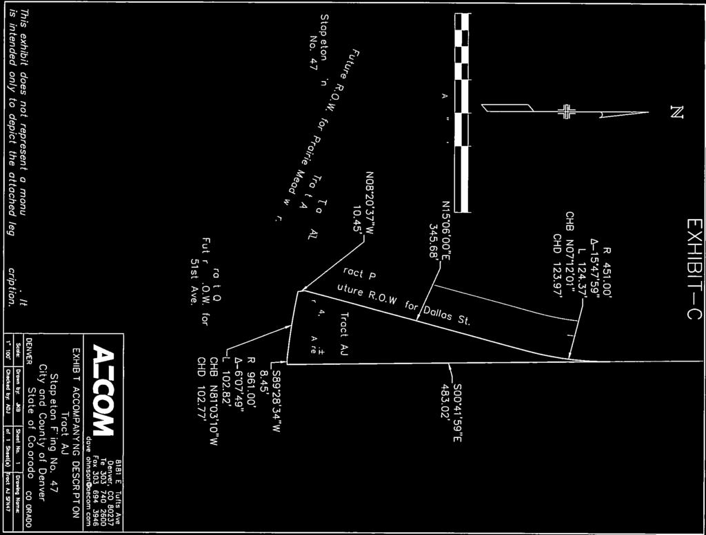
33 EXHIBIT - C Description Tract AJ, Stapleton Filing No. 47 as recorded at Reception Number in the Clerk and Recorder's Office of the City and County of Denver, State of Colorado. Containing 24,269 square feet or acres, more or less. A. David Johnson, P.L.S For and on behalf of AECOM 8181 E. Tufts Ave., Denver, CO dave.johnson@aecom.com S:\PS\12_Implementation - Zoning Code and Map\01_Amendments Team\03_Map Amendments\2015I\ Dallas St\002 - Application\Tract AJ-SFN 47 legal description Stapleton F 47 MCA Yard.rtf Page 1 of 1
REZONING GUIDE. Zone Map Amendment (Rezoning) - Application. Rezoning Application Page 1 of 3. Return completed form to
 - Application. Rezoning Application Page 1 of 3. Return completed form to") Zone Map Amendment (Rezoning) - Application COMMUNITY PLANNING & DEVELOPMENT REZONING GUIDE Rezoning Application Page 1 of 3 PROPERTY OWNER INFORMATION* CHECK IF POINT OF CONTACT FOR APPLICATION Property
Zone Map Amendment (Rezoning) - Application COMMUNITY PLANNING & DEVELOPMENT REZONING GUIDE Rezoning Application Page 1 of 3 PROPERTY OWNER INFORMATION* CHECK IF POINT OF CONTACT FOR APPLICATION Property
REZONING GUIDE. Zone Map Amendment (Rezoning) - Application. Rezoning Application Page 1 of 3. Return completed form to
 - Application. Rezoning Application Page 1 of 3. Return completed form to") COMMUNITY PLANNING & DEVELOPMENT REZONING GUIDE Rezoning Application Page 1 of 3 Zone Map Amendment (Rezoning) - Application PROPERTY OWNER INFORMATION* PROPERTY OWNER(S) REPRESENTATIVE** CHECK IF POINT
COMMUNITY PLANNING & DEVELOPMENT REZONING GUIDE Rezoning Application Page 1 of 3 Zone Map Amendment (Rezoning) - Application PROPERTY OWNER INFORMATION* PROPERTY OWNER(S) REPRESENTATIVE** CHECK IF POINT
Land Use, Transportation, and Infrastructure Committee of the Denver City Council FROM: Scott Robinson, Senior City Planner DATE: March 22, 2018 RE:
 Community Planning and Development Planning Services 201 W. Colfax Ave., Dept. 205 Denver, CO 80202 p: 720.865.2915 f: 720.865.3052 www.denvergov.org/cpd TO: Land Use, Transportation, and Infrastructure
Land Use, Transportation, and Infrastructure Committee of Denver City Council FROM: Scott Robinson, Senior City Planner DATE: December 6, 2018 RE:
 Community Planning and Development Planning Services 201 W. Colfax Ave., Dept. 205 Denver, CO 80202 p: 720.865.2915 f: 720.865.3052 www.denvergov.org/cpd TO: Land Use, Transportation, and Infrastructure
REZONING GUIDE. Zone Map Amendment (Rezoning) - Application. Rezoning Application Page 1 of 3. Return completed form to
 - Application. Rezoning Application Page 1 of 3. Return completed form to") COMMUNITY PLANNING & DEVELOPMENT REZONING GUIDE Rezoning Application Page 1 of 3 Zone Map Amendment (Rezoning) - Application PROPERTY OWNER INFORMATION* PROPERTY OWNER(S) REPRESENTATIVE** CHECK IF POINT
COMMUNITY PLANNING & DEVELOPMENT REZONING GUIDE Rezoning Application Page 1 of 3 Zone Map Amendment (Rezoning) - Application PROPERTY OWNER INFORMATION* PROPERTY OWNER(S) REPRESENTATIVE** CHECK IF POINT
Staff Report and Recommendation Based on the criteria for review in the Denver Zoning Code, Staff recommends approval for Application #2017I
 TO: Denver Planning Board, Joel Noble, Chair FROM: Theresa Lucero, Senior City Planner DATE: RE: Official Zoning Map Amendment Application #2017I-00163 Staff Report and Recommendation Based on the criteria
REZONING GUIDE. Zone Map Amendment (Rezoning) - Application. Rezoning Application Page 1 of 3. Return completed form to
 - Application. Rezoning Application Page 1 of 3. Return completed form to") Zone Map Amendment (Rezoning) - Application COMMUNITY PLANNING & DEVELOPMENT REZONING GUIDE Rezoning Application Page 1 of 3 PROPERTY OWNER INFORMATION* CHECK IF POINT OF CONTACT FOR APPLICATION Property
Zone Map Amendment (Rezoning) - Application COMMUNITY PLANNING & DEVELOPMENT REZONING GUIDE Rezoning Application Page 1 of 3 PROPERTY OWNER INFORMATION* CHECK IF POINT OF CONTACT FOR APPLICATION Property
Denver City Council Land Use, Transportation, and Infrastructure Committee FROM: Courtney Levingston, Senior City Planner DATE: July 26, 2018 RE:
 TO: Denver City Council Land Use, Transportation, and Infrastructure Committee FROM: Courtney Levingston, Senior City Planner DATE: RE: Official Zoning Map Amendment Application #2017I-00151 Staff Report
Official Zoning Map Amendment Application #2017I Gaylord Street and York Street Rezoning from U-RH-2.5 to U-RX-3 and U-RX-5
 Community Planning and Development Planning Services 201 W. Colfax Ave., Dept. 205 Denver, CO 80202 p: 720.865.2915 f: 720.865.3052 www.denvergov.org/cpd TO: Denver Planning Board FROM: Elizabeth Weigle,
Official Zoning Map Amendment Application #2017I and 4889 South Quebec Street Rezoning from B-4 with waivers, UO-1, UO-2 to C-MX-20
 Community Planning and Development Planning Services 201 W. Colfax Ave., Dept. 205 Denver, CO 80202 p: 720.865.2915 f: 720.865.3052 www.denvergov.org/cpd TO: Denver Planning Board FROM: Jeff Hirt, Senior
Land Use, Transportation, & Infrastructure Committee of the Denver City Council FROM: Chandler Van Schaack, Senior City Planner DATE: July 3, 2018 RE:
 Community Planning and Development Planning Services TO: Land Use, Transportation, & Infrastructure Committee of the Denver City Council FROM: Chandler Van Schaack, Senior City Planner DATE: July 3, 2018
Brad Buchanan, Executive Director, Department of Community Planning and Development
 TO: City Council FROM: Jeff Hirt, Senior City Planner DATE: RE: Official Zoning Map Amendment Application #2017I-00076 3400 Arkins Ct., 3460 Arkins Ct., 1900 35 th St, 1930 35th St., 1950 35 th St Rezoning
Representative Name. Address. City, State, Zip. Telephone.
 COMMUNITY PLANNING & DEVELOPMENT ~~DENVER... THE MILE HIGH CITY REZONING GUIDE Zone Map Amendment (Rezoning)- Application Rezoning Application Page 1 of 3 Property Owner Name Philip M. Falco Address 730
Telephone AC / 21,960 SF G-MU-3 G-MX-3
 Zone Map Amendment (Rezoning) - Application PROPERTY OWNER INFORMATION* CHECK IF POINT OF CONTACT FOR APPLICATION Property Owner Name Siddhartha Rathod Address City, State, Zip Telephone Email COMMUNITY
Staff Report and Recommendation Based on the criteria for review in the Denver Zoning Code, Staff recommends approval for application #2017I
 TO: Denver City Council, Land Use, Transportation and Infrastructure Committee FROM: Theresa Lucero, Senior City Planner DATE: RE: Official Zoning Map Amendment Application #2017I-00153 Staff Report and
Official Zoning Map Amendment Application #2017I-00094
 Community Planning and Development Planning Services 201 W. Colfax Ave., Dept. 205 Denver, CO 80202 p: 720.865.2915 f: 720.865.3052 www.denvergov.org/cpd TO: Denver Planning Board FROM: Scott Robinson,
To: S-MX-8 AIO, S-MX-8A AIO, S-MX-12 AIO, C-MX-8 AIO, C-MX-12 AIO, and S-CC-5 AIO
 Community Planning and Development Planning Services 201 W. Colfax Ave., Dept. 205 Denver, CO 80202 p: 720.865.2915 f: 720.865.3052 www.denvergov.org/cpd TO: Denver City Council FROM: Curt Upton, Senior
REZONING GUIDE. Zone Map Amendment (Rezoning) - Application. Rezoning Application Page 1 of 3. Return completed form to
 - Application. Rezoning Application Page 1 of 3. Return completed form to") Zone Map Amendment (Rezoning) - Application COMMUNITY PLANNING & DEVELOPMENT REZONING GUIDE Rezoning Application Page 1 of 3 PROPERTY OWNER INFORMATION* CHECK IF POINT OF CONTACT FOR APPLICATION Property
Zone Map Amendment (Rezoning) - Application COMMUNITY PLANNING & DEVELOPMENT REZONING GUIDE Rezoning Application Page 1 of 3 PROPERTY OWNER INFORMATION* CHECK IF POINT OF CONTACT FOR APPLICATION Property
Official Zoning Map Amendment Application #2018I-00120
 Community Planning and Development Planning Services 201 W. Colfax Ave., Dept. 205 Denver, CO 80202 p: 720.865.2915 f: 720.865.3052 www.denvergov.org/cpd TO: Denver Planning Board FROM: Scott Robinson,
Block bounded by Newton St., 17 th Ave., Lowell Blvd., and 16 th Ave.; plus Meade Street (evens only)
") Community Planning and Development Planning Services 201 W. Colfax Ave., Dept. 205 Denver, CO 80202 p: 720.865.2915 f: 720.865.3052 www.denvergov.org/cpd TO: Denver Planning Board FROM: Sara White, AICP,
Community Planning and Development Planning Services 201 W. Colfax Ave., Dept. 205 Denver, CO 80202 p: 720.865.2915 f: 720.865.3052 www.denvergov.org/cpd TO: Denver Planning Board FROM: Sara White, AICP,
Official Zoning Map Amendment Application #2015I Marion St. Rezoning from U-SU-A1 to U-MX-2x
 Community Planning and Development Planning Services 201 W. Colfax Ave., Dept. 205 Denver, CO 80202 p: 720.865.2915 f: 720.865.3052 www.denvergov.org/cpd TO: Denver City Council FROM: Courtland Hyser,
Official Zoning Map Amendment Application #2018I-00067
 Community Planning and Development Planning Services 201 W. Colfax Ave., Dept. 205 Denver, CO 80202 p: 720.865.2915 f: 720.865.3052 www.denvergov.org/cpd TO: Denver Planning Board FROM: Courtney Levingston,
Official Zoning Map Amendment Application #2018I-00095
 Community Planning and Development Planning Services 201 W. Colfax Ave., Dept. 205 Denver, CO 80202 p: 720.865.2915 f: 720.865.3052 www.denvergov.org/cpd TO: Denver Planning Board FROM: Ella Stueve, Senior
Article 3. SUBURBAN (S-) NEIGHBORHOOD CONTEXT
 NEIGHBORHOOD CONTEXT") Article 3. SUBURBAN (S-) NEIGHBORHOOD CONTEXT this page left intentionally blank Contents ARTICLE 3. SUBURBAN (S-) NEIGHBORHOOD CONTEXT DIVISION 3.1 NEIGHBORHOOD CONTEXT DESCRIPTION...3.1-1 Section 3.1.1
Article 3. SUBURBAN (S-) NEIGHBORHOOD CONTEXT this page left intentionally blank Contents ARTICLE 3. SUBURBAN (S-) NEIGHBORHOOD CONTEXT DIVISION 3.1 NEIGHBORHOOD CONTEXT DESCRIPTION...3.1-1 Section 3.1.1
Based on the criteria for review in the Denver Zoning Code, Staff recommends approval for Application #2018I
 Community Planning and Development Planning Services 201 W. Colfax Ave., Dept. 205 Denver, CO 80202 p: 720.865.2915 f: 720.865.3052 www.denvergov.org/cpd TO: Denver Planning Board FROM: Chandler Van Schaack,
Official Zoning Map Amendment Application #2017I-00090
 Community Planning and Development Planning Services 201 W. Colfax Ave., Dept. 205 Denver, CO 80202 p: 720.865.2915 f: 720.865.3052 www.denvergov.org/cpd TO: Land Use, Transportation, & Infrastructure
E-SU-A. Zone Map Amendment (Rezoning) -Application E-SU-B. Rf tum cornpleted form to rezoning(i:})denvergov.org. *If More Than One Property Owner;
 -Application E-SU-B. Rf tum cornpleted form to rezoning(i:})denvergov.org. *If More Than One Property Owner;") Zone Map Amendment (Rezoning) -Application Property Owner Name Philip M. Falco Representative Name Address 730 17th Street, Suite 900 Address City, State, Zip Denver, CO 80202 City, State, Zip Telephone
Zone Map Amendment (Rezoning) -Application Property Owner Name Philip M. Falco Representative Name Address 730 17th Street, Suite 900 Address City, State, Zip Denver, CO 80202 City, State, Zip Telephone
Official Zoning Map Amendment Application #2015I N. King Street and 3441 W. 39 th Ave Rezoning from PUD 406 to U-SU-B1
 Community Planning and Development Planning Services 201 W. Colfax Ave., Dept. 205 Denver, CO 80202 p: 720.865.2915 f: 720.865.3052 www.denvergov.org/cpd TO: Neighborhoods and Planning Committee FROM:
Public Review of the Slot Home Text Amendment
 Public Review of the Slot Home Text Amendment The proposed amendments to the Denver Zoning Code have been informed by the Slot Home Strategy Report. This document has been developed out of a robust process
Staff Report and Recommendation
 Community Planning and Development Planning Services 201 W. Colfax Ave., Dept. 205 Denver, CO 80202 p: 720.865.2915 f: 720.865.3052 www.denvergov.org/cpd TO: Denver Planning Board FROM: Andrew Webb, Senior
REZONING GUIDE. Zone Map Amendment (Rezoning) - Application. Rezoning Application Page 1 of 3. Return completed form to
 - Application. Rezoning Application Page 1 of 3. Return completed form to") Zone Map Amendment (Rezoning) - Application COMMUNITY PLANNING & DEVELOPMENT REZONING GUIDE Rezoning Application Page 1 of 3 PROPERTY OWNER INFORMATION* CHECK IF POINT OF CONTACT FOR APPLICATION Property
Zone Map Amendment (Rezoning) - Application COMMUNITY PLANNING & DEVELOPMENT REZONING GUIDE Rezoning Application Page 1 of 3 PROPERTY OWNER INFORMATION* CHECK IF POINT OF CONTACT FOR APPLICATION Property
Appendix A: Guide to Zoning Categories Prince George's County, Maryland
 Appendix A: Guide to Zoning Categories Prince George's County, Maryland RESIDENTIAL ZONES 1 Updated November 2010 R-O-S: Reserved Open Space - Provides for permanent maintenance of certain areas of land
ARTICLE 3: Zone Districts
 ARTICLE 3: Zone Districts... 3-1 17.3.1: General...3-1 17.3.1.1: Purpose and Intent... 3-1 17.3.2: Districts and Maps...3-1 17.3.2.1: Applicability... 3-1 17.3.2.2: Creation of Districts... 3-1 17.3.2.3:
Bylaw No , being "Official Community Plan Bylaw, 2016" Schedule "A" DRAFT
 Bylaw No. 2600-2016, being "Official Community Plan Bylaw, 2016" Schedule "A" Urban Structure + Growth Plan Urban Structure Land use and growth management are among the most powerful policy tools at the
REZONING GUIDE. Zone Map Amendment (Rezoning) - Application. Applicant: Albus Brooks, Councilman District 9
 - Application. Applicant: Albus Brooks, Councilman District 9") Zone Map Amendment (Rezoning) - Application COMMUNITY PLANNING & DEVELOPMENT REZONING GUIDE Rezoning Application Page 1 of 3 PROPERTY OWNER INFORMATION* CHECK IF POINT OF CONTACT FOR APPLICATION Property
Zone Map Amendment (Rezoning) - Application COMMUNITY PLANNING & DEVELOPMENT REZONING GUIDE Rezoning Application Page 1 of 3 PROPERTY OWNER INFORMATION* CHECK IF POINT OF CONTACT FOR APPLICATION Property
PLANNING COMMISSION STAFF REPORT
 PLANNING COMMISSION STAFF REPORT REZONING CASE: RZ-16-001 REPORT DATE: March 8, 2016 CASE NAME: Trailbreak Partners Rezoning PLANNING COMMISSION DATE: March 16, 2016 ADDRESSES OF REZONING PROPOSAL: 5501
E-SU-A. Zone Map Amendment (Rezoning) -Application E-SU-B. Rf tum cornpleted form to rezoning(i:})denvergov.org. *If More Than One Property Owner;
 -Application E-SU-B. Rf tum cornpleted form to rezoning(i:})denvergov.org. *If More Than One Property Owner;") Zone Map Amendment (Rezoning) -Application Property Owner Name Philip M. Falco Representative Name Address 730 17th Street, Suite 900 Address City, State, Zip Denver, CO 80202 City, State, Zip Telephone
Zone Map Amendment (Rezoning) -Application Property Owner Name Philip M. Falco Representative Name Address 730 17th Street, Suite 900 Address City, State, Zip Denver, CO 80202 City, State, Zip Telephone
PLANNING COMMISSION STAFF REPORT
 PLANNING COMMISSION STAFF REPORT West Capitol Hill Zoning Map Amendment Petition No. PLNPCM2011-00665 Located approximately at 548 W 300 North Street, 543 W 400 North Street, and 375 N 500 West Street
Article 6. GENERAL URBAN (G-) NEIGHBORHOOD CONTEXT
 NEIGHBORHOOD CONTEXT") Article 6. GENERAL URBAN (G-) NEIGHBORHOOD CONTEXT this page left intentionally blank Contents ARTICLE 6. GENERAL URBAN (G-) NEIGHBORHOOD CONTEXT DIVISION 6.1 NEIGHBORHOOD CONTEXT DESCRIPTION...6.1-1 Section
Article 6. GENERAL URBAN (G-) NEIGHBORHOOD CONTEXT this page left intentionally blank Contents ARTICLE 6. GENERAL URBAN (G-) NEIGHBORHOOD CONTEXT DIVISION 6.1 NEIGHBORHOOD CONTEXT DESCRIPTION...6.1-1 Section
REQUEST STAFF RECOMMENDATION. On April 26, 2012, Signature Books Inc., represented by Dave Richards, submitted petitions for the following amendments:
 PLANNING COMMISSION STAFF REPORT Signature Books Zoning Map Amendment and an Amendment to the North Temple Area Plan Petitions PLNPCM2012-00254 PLNPCM2012-00255 July 11, 2012 Planning Division Department
REZONING GUIDE. Zone Map Amendment (Rezoning) - Application. Rezoning Application Page 1 of 3. Return completed form to
 - Application. Rezoning Application Page 1 of 3. Return completed form to") COMMUNITY PLANNING & DEVELOPMENT REZONING GUIDE Rezoning Application Page 1 of 3 Zone Map Amendment (Rezoning) - Application PROPERTY OWNER INFORMATION* PROPERTY OWNER(S) REPRESENTATIVE** CHECK IF POINT
COMMUNITY PLANNING & DEVELOPMENT REZONING GUIDE Rezoning Application Page 1 of 3 Zone Map Amendment (Rezoning) - Application PROPERTY OWNER INFORMATION* PROPERTY OWNER(S) REPRESENTATIVE** CHECK IF POINT
DZC and DRMC Amendments to Implement 38th and Blake Station Area Height Amendments
 DZC and DRMC Amendments to Implement 38th and Blake Station Area Height Amendments DZC Text Amendment #2 to establish River North Design Overlay (DO-7) / 38 th and Blake Incentive Overlay (IO-1) (CB18-0016)
Chapter 1107: Zoning Districts
 Chapter 1107: Zoning Districts 1107.01 Establishment of Zoning Districts (a) Districts Established In order to carry out the purpose of this code, the City is hereby divided into the zoning districts established
Zone Map Amendment (Rezoning) for PUD - Application York St. U-MX-3, B-2 with Waivers. General PUD. Yes. See Attachment C U-MX-3, I-MX-3
 for PUD - Application York St. U-MX-3, B-2 with Waivers. General PUD. Yes. See Attachment C U-MX-3, I-MX-3") COMMUNITY PLANNING & DEVELOPMENT REZONING GUIDE Rezoning Application for PUD Page 1 of 3 Zone Map Amendment (Rezoning) for PUD - Application PROPERTY OWNER INFORMATION* CHECK IF POINT OF CONTACT FOR APPLICATION
COMMUNITY PLANNING & DEVELOPMENT REZONING GUIDE Rezoning Application for PUD Page 1 of 3 Zone Map Amendment (Rezoning) for PUD - Application PROPERTY OWNER INFORMATION* CHECK IF POINT OF CONTACT FOR APPLICATION
PLANNING COMMISSION PUBLIC HEARING STAFF REPORT ZRTD FAIRFAX MARBLE & GRANITE
 Date of Hearing: PLANNING COMMISSION PUBLIC HEARING STAFF REPORT SUBJECT: ELECTION DISTRICT: ZRTD-2016-0009 FAIRFAX MARBLE & GRANITE Broad Run CRITICAL ACTION DATE: September 27, 2017 STAFF CONTACTS: APPLICANT:
PLANNING COMMISSION REPORT Regular Agenda Public Hearing Item
 PC Staff Report 11/12/12 Item No. 2B- 1 PLANNING COMMISSION REPORT Regular Agenda Public Hearing Item ITEM NO. 2B: A TO GPI; 110 ACRES; E OF K-10 & N OF W 6 TH ST (MKM) : Consider a request to rezone approximately
PLANNED UNIT DEVELOPMENT & SUBDIVISION STAFF REPORT Date: April 18, 2019
 PLANNED UNIT DEVELOPMENT & SUBDIVISION STAFF REPORT Date: April 18, 2019 DEVELOPMENT NAME SUBDIVISION NAME Springhill Village Subdivision Springhill Village Subdivision LOCATION 4350, 4354, 4356, 4358,
Guide to Combined Preliminary and Final Plats
 Guide to Combined Preliminary and Final Plats Introduction The Douglas County is committed to providing open, transparent application processes to the public. This Guide is provided to assist anyone interested
Guide to Replats. Step 1. Step 2. Step 3. Step 4. Step 5. Step 6. Step 7. Step 8. Step 9. Step 10
 Guide to Replats Introduction Douglas County is committed to providing open, transparent application processes to the public. This Guide is provided to assist anyone interested in the procedures and expectations
PIN , Part 1, Plan SR-713 in Lot 2, Concession 5, Township of McKim (1096 Dublin Street, Sudbury)
") STAFF REPORT Applicant: Dalron Construction Limited Location: PIN 02124-0103, Part 1, Plan SR-713 in Lot 2, Concession 5, Township of McKim (1096 Dublin Street, Sudbury) Official Plan and Zoning By-law:
STAFF REPORT Applicant: Dalron Construction Limited Location: PIN 02124-0103, Part 1, Plan SR-713 in Lot 2, Concession 5, Township of McKim (1096 Dublin Street, Sudbury) Official Plan and Zoning By-law:
PC Staff Report 11/18/2013 Z Item No. 1-1
 Z-13-00401 Item No. 1-1 PLANNING COMMISSION REPORT Regular Agenda - Public Hearing Item PC Staff Report 11/18/2013 ITEM NO. 1: Z-13-00401 IG (General Industrial) District TO CS (Strip Commercial) District;
City of Valdosta Land Development Regulations
 Chapter 206 Section 206-1 Base Zoning Districts Standards for Uses, Structures, and Property Development (B) (C) Principal Uses and Structures. Principal uses and structures permitted in each base zoning
STAFF REPORT FOR MAJOR SUBDIVISION
 STAFF REPORT FOR MAJOR SUBDIVISION FINAL PLAT CASE NO. FA-13-001 HEARING DATE: November 6, 2013 CASE NAME: Solterra Subdivision Filing No. 14 PROCEDURE: Planning Commission ADDRESS OF MAJOR SUBDIVISION
CITY OF NORTH LAS VEGAS MEMORANDUM
 CITY OF NORTH LAS VEGAS MEMORANDUM TO: FROM: SUBJECT: Planning Commission Community Development and Compliance Department # 28 ) AMP-03-15; Coleman Airpark II & III - Comprehensive Plan Amendment (Public
Guide to Minor Developments
 Guide to Minor Developments Introduction The Douglas County (DCD) is committed to providing open, transparent application processes to the public. This Guide is provided to assist anyone interested in
STAFF REPORT. Permit Number: Unlimited. Kitsap County Board of Commissioners; Kitsap County Planning Commission
 STAFF REPORT Permit Number: 15 00550 Unlimited DATE: March 2, 2016 TO: FROM: Kitsap County Board of Commissioners; Kitsap County Planning Commission Katrina Knutson, AICP, Senior Planner, DCD and Jeff
Action Recommendation: Budget Impact:
 City of Fayetteville Staff Review Form 2018-0477 Legistar File ID 9/18/2018 City Council Meeting Date - Agenda Item Only N/A for Non-Agenda Item Garner Stoll Submitted By 8/28/2018 Submitted Date Action
Planning Department Oconee County, Georgia
 Planning Department Oconee County, Georgia STAFF REPORT REZONE CASE #: 6985 DATE: October 31, 2016 STAFF REPORT BY: Andrew C. Stern, Planner APPLICANT NAME: Williams & Associates, Land Planners PC PROPERTY
RECOMMENDATION Following the public hearing, consider Zoning Case PD14-16, with a Development Plan.
 Staff Report Zoning Case PD14-16 (Helzer Tract) Planning and Zoning Meeting Date: 12-17-14 Document Being Considered: Ordinance RECOMMENDATION Following the public hearing, consider Zoning Case PD14-16,
Planning Justification Report
 Planning Justification Report Kellogg s Lands City of London E&E McLaughlin Ltd. June 14, 2017 Zelinka Priamo Ltd. Page i TABLE OF CONTENTS Page No. 1.0 2.0 2.1 2.2 3.0 4.0 5.0 5.1 5.2 5.3 5.4 5.5 5.6
PLANNING COMMISSION REPORT Regular Agenda - Public Hearing Item
 Z-15-00469 Item No. 6A- 1 PLANNING COMMISSION REPORT Regular Agenda - Public Hearing Item PC Staff Report 11/16/15 ITEM NO. 6A GPI, RM12, & RS40 TO RM12; 14.756 ACRES; 5200 & 5300 CLINTON PKWY (SLD) Z-15-00469:
Cover Letter with Narrative Statement
 Cover Letter with Narrative Statement March 31, 2017 rev July 27, 2017 RE: Rushton Pointe Residential Planned Unit Development Application for Public Hearing for RPUD Rezone PL2015 000 0306 Mr. Eric Johnson,
TOOELE COUNTY LAND USE ORDINANCE CHAPTER 31 Page 1
 CHAPTER 31 PLANNED COMMUNITY ZONE (P-C) Section 31-1 Definitions. 31-2 Purpose. 31-3 Land use districts. 31-4 P-C zone area minimum requirements. 31-5 Permitted uses. 31-6 Conditional uses. 31-7 Planning
3.1. OBJECTIVES FOR RESIDENTIAL LAND USE DESIGNATIONS GENERAL OBJECTIVES FOR ALL RESIDENTIAL DESIGNATIONS
 3. RESIDENTIAL LAND USE DESIGNATIONS INTRODUCTION The Residential land use designations provide for housing and other land uses that are integral to, and supportive of, a residential environment. Housing
HOUSING ELEMENT GOALS, OBJECTIVES, AND POLICIES
 HOUSING ELEMENT GOALS, OBJECTIVES, AND POLICIES GOAL 1: To promote the preservation and development of high-quality, balanced, and diverse housing options for persons of all income levels throughout the
Town of Cary, North Carolina Rezoning Staff Report 14-REZ-31 Cary Park PDD Amendment (Waterford II) Town Council Meeting January 15, 2015
 Town Council Meeting January 15, 2015") Town of Cary, North Carolina Rezoning Staff Report 14-REZ-31 Cary Park PDD Amendment (Waterford II) Town Council Meeting January 15, 2015 REQUEST To amend the Town of Cary Official Zoning Map by amending
Town of Cary, North Carolina Rezoning Staff Report 14-REZ-31 Cary Park PDD Amendment (Waterford II) Town Council Meeting January 15, 2015 REQUEST To amend the Town of Cary Official Zoning Map by amending
 PROJECT NARRATIVE AVENIR PCD MISCELLANEOUS AMENDMENT November 27, 2018 Urban Planning and Design Landscape Architecture Communication Graphics Request Avenir Development, LLC and Avenir Holdings, LLC,
8/17/16 PC Meeting 1
 1 GENERAL INFORMATION OWNER/APPLICANT: Thomas Corff & Terry Moberly (1943 13 th St.) 19328 Towercrest Dr. Oregon City, OR 97045 Michael & Jill Parker (1983 13 th St.) 1708 Oak St. Lake Oswego, OR 97034
Town of Jamestown Planning Board Zoning Staff Report June 14, 2010
 Town of Jamestown Planning Board Zoning Staff Report June 14, 2010 The information provided in this staff report has been included for the purpose of reviewing proposed zoning changes. Since the zoning
ZONING AMENDMENT & SUBDIVISION STAFF REPORT Date: March 1, 2018
 #13 SUB-000406-2018 & ZON-000407-2018 ZONING AMENDMENT & SUBDIVISION STAFF REPORT Date: March 1, 2018 NAME SUBDIVISION NAME LOCATION Creekside @ Kooiman Dairy Creekside @ Kooiman Dairy Subdivision (South
Conditional Use Permit case no. CU 14-06: Bristol Village Partners, LLC
 PLANNING AND ZONING COMMISSION STAFF REPORT August 7, 2014 Conditional Use Permit case no. CU 14-06: Bristol Village Partners, LLC CASE DESCRIPTION: LOCATION: LEGAL DESCRIPTION: EXISTING LAND USE: ZONING:
Glades County Staff Report and Recommendation Unified Staff Report for Small Scale Plan Amendment and Rezoning
 Glades County Staff Report and Recommendation Unified Staff Report for Small Scale Plan Amendment and Rezoning CASE NUMBERS: COMP17-02 and RZ17-02 DATE of STAFF REPORT: May 1, 2017 CASE TYPE: Application
CHAPTER 14 PLANNED UNIT DEVELOPMENTS
 9-14-1 9-14-1 CHAPTER 14 PLANNED UNIT DEVELOPMENTS SECTION: 9-14-1: Purpose 9-14-2: Governing Provisions 9-14-3: Minimum Area 9-14-4: Uses Permitted 9-14-5: Common Open Space 9-14-6: Utility Requirements
PLANNING COMMISSION REPORT Regular Agenda - Public Hearing Item
 Z-14-00056 Item No. 1-1 PLANNING COMMISSION REPORT Regular Agenda - Public Hearing Item PC Staff Report 4/21/2014 ITEM NO. 1: RSO TO CN1;.126 ACRES; 512 & 514 LOCUST ST (DRG) Z-14-00056: Consider a request
STAFF REPORT FOR MAJOR SUBDIVISION
 STAFF REPORT FOR MAJOR SUBDIVISION FINAL PLAT CASE NO. FA-14-001 HEARING DATE: January 6, 2016 CASE NAME: Solterra Subdivision Filing No. 16 PROCEDURE: Planning Commission ADDRESS OF MAJOR SUBDIVISION
ZRTD , Glenn Drive. M. Tyler Klein, AICP, Project Manager, Planning and Zoning John Merrithew, Acting Director, Planning and Zoning
 DEPARTMENT OF PLANNING Date of Hearing: AND ZONING STAFF REPORT # 4 BOARD OF SUPERVISORS PUBLIC HEARING SUBJECT: ELECTION DISTRICT: ZRTD-2014-0003, 22675 Glenn Drive Broad Run CRITICAL ACTION DATE: September
891941, , : COMPREHENSIVE PLAN AMENDMENT, COMMUNITY PLAN AMENDMENT, AND AREA-WIDE MAP AMENDMENT
 Application Nos. 891941, 891909, 891940: COMPREHENSIVE PLAN AMENDMENT, COMMUNITY PLAN AMENDMENT, AND AREA-WIDE MAP AMENDMENT Amendments to designate five parcels as Rural Industrial Center in the Alderton
REZONING GUIDE. Zone Map Amendment (Rezoning) - Application. Rezoning Application Page 1 of 3. Return completed form to
 - Application. Rezoning Application Page 1 of 3. Return completed form to") COMMUNITY PLANNING & DEVELOPMENT REZONING GUIDE Rezoning Application Page 1 of 3 Zone Map Amendment (Rezoning) - Application PROPERTY OWNER INFORMATION* PROPERTY OWNER(S) REPRESENTATIVE** CHECK IF POINT
COMMUNITY PLANNING & DEVELOPMENT REZONING GUIDE Rezoning Application Page 1 of 3 Zone Map Amendment (Rezoning) - Application PROPERTY OWNER INFORMATION* PROPERTY OWNER(S) REPRESENTATIVE** CHECK IF POINT
Midwest City, Oklahoma Zoning Ordinance
 2010 Midwest City, Oklahoma Zoning Ordinance 9/2/2010 Table of Contents Section 1. General Provisions... 5 1.1. Citation... 5 1.2. Authority... 5 1.3. Purpose... 5 1.4. Nature and Application... 5 1.5.
ZONING ORDINANCE: OPEN SPACE COMMUNITY. Hamburg Township, MI
 ZONING ORDINANCE: OPEN SPACE COMMUNITY Hamburg Township, MI ARTICLE 14.00 OPEN SPACE COMMUNITY (Adopted 1/16/92) Section 14.1. Intent It is the intent of this Article to offer an alternative to traditional
Article 7. URBAN CENTER (C-) NEIGHBORHOOD CONTEXT
 NEIGHBORHOOD CONTEXT") Article 7. URBAN CENTER (C-) NEIGHBORHOOD CONTEXT this page left intentionally blank Contents ARTICLE 7. URBAN CENTER (C-) NEIGHBORHOOD CONTEXT DIVISION 7.1 NEIGHBORHOOD CONTEXT DESCRIPTION.........................
Article 7. URBAN CENTER (C-) NEIGHBORHOOD CONTEXT this page left intentionally blank Contents ARTICLE 7. URBAN CENTER (C-) NEIGHBORHOOD CONTEXT DIVISION 7.1 NEIGHBORHOOD CONTEXT DESCRIPTION.........................
Denver Zoning Code Amendment General Development Plan Revisions REDLINE PUBLIC REVIEW DRAFT 1/16/19
 Denver Zoning Code Amendment General Development Plan Revisions REDLINE PUBLIC REVIEW DRAFT 1/16/19 This document contains the redlined draft of a proposed text amendment and rules and regulations to revamp
ARTICLE I ZONE BASED REGULATIONS
 ARTICLE I ZONE BASED REGULATIONS RZC 21.08 RESIDENTIAL REGULATIONS 21.08.290 Cottage Housing Developments A. Purpose. The purpose of the cottage housing requirements is to: 1. Provide a housing type that
TOWN OF ORO VALLEY PLANNING & ZONING COMMISSION MEETING DATE: December 6, 2011
 PLANNING & ZONING COMMISSION MEETING DATE: December 6, 2011 TO: FROM: SUBJECT: PLANNING & ZONING COMMISSION Matt Michels, Senior Planner mmichels@orovalleyaz.gov; tel. 229-4822 Public Hearing: Rancho de
MIDWAY CITY Municipal Code
 MIDWAY CITY Municipal Code TITLE 9 ANNEXATION CHAPTER 9.01 PURPOSE CHAPTER 9.02 GENERAL REQUIREMENTS CHAPTER 9.03 PROPERTY OWNER INITIATION OF ANNEXATION CHAPTER 9.04 PROCEDURES FOR CONSIDERATION OF PETITION
Rapid City Planning Commission
 Rapid City Planning Commission Initial Planned Development Overlay Project Report March 9, 2017 Item #15 Applicant Request(s) Case # 17PD007 Initial Planned Development Overlay to allow a residential development
Attachment 4. Planning Commission Staff Report. June 26, 2017
 Planning Commission Staff Report June 26, 2017 Agenda #: Regular Agenda - 2 Title: Applicant: Request: Location: Existing Zoning: Proposed Use: Staff Planner: The Brands and The Brands West Eagle Crossing
SPECIAL ZONING DISTRICTS
 SPECIAL ZONING DISTRICTS 5.01 5.99 RESERVED 5.100 PLANNED DEVELOPMENTS: Purpose: This district is intended to accommodate unified design of residential, commercial, office, professional services, retail
DIVISION 1.3 OFFICIAL ZONING MAP
 Article 1. General Provisions Division 1.3 Official Zone Map DIVISION 1.3 OFFICIAL ZONING MAP SECTION 1.3.1 ADOPTION OF OFFICIAL MAP The digital maps created and maintained by the Department of Community
13 Sectional Map Amendment
 13 Sectional Map Amendment Introduction This chapter reviews land use and zoning policies and practices in Prince George s County and presents the proposed zoning in the sectional map amendment (SMA) to
PLANNING COMMISSION PUBLIC HEARING STAFF REPORT ZRTD NVA DEVELOPMENT
 Date of Hearing: PLANNING COMMISSION PUBLIC HEARING STAFF REPORT SUBJECT: ELECTION DISTRICT: ZRTD-2016-0005 NVA DEVELOPMENT Broad Run CRITICAL ACTION DATE: July 18, 2017 STAFF CONTACTS: APPLICANT: Jacqueline
ATTACHMENT #1 SUMMARY CHART
 ATTACHMENT #1 SUMMARY CHART Item # Amendment To: Nature of Proposed Amendment PCM201801 PCM201802 PCM201803 PCM201804 LMA201802 LMA201803 LMA201804 PCT201801 PCT201802 PCT201803 FUTURE LAND USE MAP Parkway
GENERAL DESCRIPTION STAFF RECOMMENDATION IMPLEMENTATION REQUIREMENTS
 Application No.: 891418 Applicant: AREA-WIDE MAP AMENDMENT Rezone two parcels from Moderate Density Single Family (MSF) to Neighborhood Center (NC) and Employment Center (EC). Charles Bitton GENERAL DESCRIPTION
REZONING APPLICATION INSTRUCTIONS
 REZONING APPLICATION INSTRUCTIONS All required information, as stated on the Rezoning Application Checklist, must be included to qualify as a complete application. Upon receipt, staff will review the application
STAFF REPORT. Community Development Director PO Box 4755 Beaverton, OR 97076
 STAFF REPORT HEARING DATE: July 7, 2010 TO: Planning Commission STAFF: Jana Fox, Assistant Planner PROPOSAL: Southeast Beaverton Office Commercial Zoning Map Amendment (ZMA2010-0006) LOCATION: The subject
REPORT OF THE PLANNING AND DEVELOPMENT DEPARTMENT FOR APPLICATION FOR REZONING ORDINANCE TO PLANNED UNIT DEVELOPMENT AUGUST 20, 2015
 BEL REPORT OF THE PLANNING AND DEVELOPMENT DEPARTMENT FOR APPLICATION FOR REZONING ORDINANCE TO PLANNED UNIT DEVELOPMENT AUGUST 20, 2015 The Planning and Development Department hereby forwards to the Planning
United States Post Office and Multi-Family Residential; and, Single- Family Residence with an Apartment
 Planning Commission File No.: AME2013 0009 January 9, 2014 Page 2 of 9 Existing Land Use: United States Post Office and Multi-Family Residential; and, Single- Family Residence with an Apartment Surrounding
Chapter Planned Residential Development Overlay
 Chapter 19.29 Planned Residential Development Overlay Sections 010 Purpose 020 Scope 030 Definitions 030 Minimum Size 040 Allowable Uses 050 Minimum Development Standards 060 Density Bonus 070 Open Space
STAFF REPORT. Permit Number: Porter. Kitsap County Board of Commissioners; Kitsap County Planning Commission
 STAFF REPORT Permit Number: 15 00461 Porter DATE: November 9, 2015 TO: FROM: Kitsap County Board of Commissioners; Kitsap County Planning Commission Katrina Knutson, AICP, Senior Planner, DCD and Jeff