REZONING GUIDE. Zone Map Amendment (Rezoning) - Application. Rezoning Application Page 1 of 3. Return completed form to
|
|
|
- Kristin Barrett
- 5 years ago
- Views:
Transcription
 REPRESENTATIVE** CHECK IF POINT OF CONTACT FOR APPLICATION Representative Name Address City, State, Zip Telephone Email *If")
1 Zone Map Amendment (Rezoning) - Application COMMUNITY PLANNING & DEVELOPMENT REZONING GUIDE Rezoning Application Page 1 of 3 PROPERTY OWNER INFORMATION* CHECK IF POINT OF CONTACT FOR APPLICATION Property Owner Name Address City, State, Zip Telephone PROPERTY OWNER(S) REPRESENTATIVE** CHECK IF POINT OF CONTACT FOR APPLICATION Representative Name Address City, State, Zip Telephone *If More Than One Property Owner: All standard zone map amendment applications shall be initiated by all the owners of at least 51% of the total area of the zone lots subject to the rezoning application, or their representatives authorized in writing to do so. See page 3. **Property owner shall provide a written letter authorizing the representative to act on his/her behalf. Please attach Proof of Ownership acceptable to the Manager for each property owner signing the application, such as (a) Assessor s Record, (b) Warranty deed or deed of trust, or (c) Title policy or commitment dated no earlier than 60 days prior to application date. If the owner is a corporate entity, proof of authorization for an individual to sign on behalf of the organization is required. This can include board resolutions authorizing the signer, bylaws, a Statement of Authority, or other legal documents as approved by the City Attorney s Office. SUBJECT PROPERTY INFORMATION Location (address and/or boundary description): Assessor s Parcel Numbers: Area in Acres or Square Feet: Current Zone District(s): PROPOSAL Proposed Zone District: Last updated: February 22, 2017 Return completed form to rezoning@denvergov.org 201 W. Colfax Ave., Dept. 205 Denver, CO rezoning@denvergov.org
2 COMMUNITY PLANNING & DEVELOPMENT REZONING GUIDE Rezoning Application Page 2 of 3 REVIEW CRITERIA Consistency with Adopted Plans: The proposed official map amendment is consistent with the City s adopted plans, or the proposed rezoning is necessary to provide land for a community need that was not anticipated at the time of adoption of the City s Plan. General Review Criteria: The proposal must comply with all of the general review criteria DZC Sec Additional Review Criteria for Non-Legislative Rezonings: The proposal must comply with both of the additional review criteria DZC Sec Please provide an attachment describing relevant adopted plans and how proposed map amendment is consistent with those plan recommendations; or, describe how the map amendment is necessary to provide for an unanticipated community need. Uniformity of District Regulations and Restrictions: The proposed official map amendment results in regulations and restrictions that are uniform for each kind of building throughout each district having the same classification and bearing the same symbol or designation on the official map, but the regulations in one district may differ from those in other districts. Public Health, Safety and General Welfare: The proposed official map amendment furthers the public health, safety, and general welfare of the City. Justifying Circumstances - One of the following circumstances exists: The existing zoning of the land was the result of an error. The existing zoning of the land was based on a mistake of fact. The existing zoning of the land failed to take into account the constraints on development created by the natural characteristics of the land, including, but not limited to, steep slopes, floodplain, unstable soils, and inadequate drainage. The land or its surroundings has changed or is changing to such a degree that it is in the public interest to encourage a redevelopment of the area to recognize the changed character of the area. It is in the public interest to encourage a departure from the existing zoning through application of supplemental zoning regulations that are consistent with the intent and purpose of, and meet the specific criteria stated in, Article 9, Division 9.4 (Overlay Zone Districts), of this Code. Please provide an attachment describing the justifying circumstance. The proposed official map amendment is consistent with the description of the applicable neighborhood context, and with the stated purpose and intent of the proposed Zone District. REQUIRED ATTACHMENTS Please provide an attachment describing how the above criterion is met. Please ensure the following required attachments are submitted with this application: Legal Description (required to be attached in Microsoft Word document format) Proof of Ownership Document(s) Review Criteria ADDITIONAL ATTACHMENTS Please identify any additional attachments provided with this application: Written Authorization to Represent Property Owner(s) Individual Authorization to Sign on Behalf of a Corporate Entity Please list any additional attachments: Last updated: February 22, 2017 Return completed form to rezoning@denvergov.org 201 W. Colfax Ave., Dept. 205 Denver, CO rezoning@denvergov.org
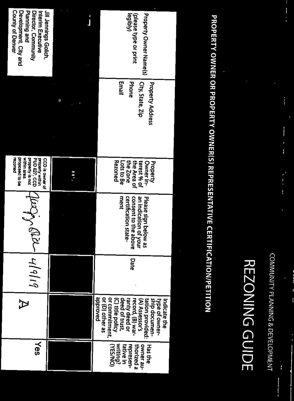
3 COMMUNITY PLANNING & DEVELOPMENT REZONING GUIDE Rezoning Application Page 3 of 3 PROPERTY OWNER OR PROPERTY OWNER(S) REPRESENTATIVE CERTIFICATION/PETITION We, the undersigned represent that we are the owners of the property described opposite our names, or have the authorization to sign on behalf of the owner as evidenced by a Power of Attorney or other authorization attached, and that we do hereby request initiation of this application. I hereby certify that, to the best of my knowledge and belief, all information supplied with this application is true and accurate. I understand that without such owner consent, the requested official map amendment action cannot lawfully be accomplished. Property Owner Name(s) (please type or print legibly) EXAMPLE John Alan Smith and Josie Q. Smith Property Address City, State, Zip Phone Property Owner Interest % of the Area of the Zone Lots to Be Rezoned Please sign below as an indication of your consent to the above certification statement Date Indicate the type of ownership documentation provided: (A) Assessor s record, (B) warranty deed or deed of trust, (C) title policy or commitment, or (D) other as approved Has the owner authorized a representative in writing? (YES/NO) (A) YES 123 Sesame Street Denver, CO (303) % John Alan Smith Josie Q. Smith 01/01/12 sample@sample.gov 226 Monroe Street LLC 226 Monroe Street LLC 226 Monroe Street LLC 226 Monroe Street LLC Last updated: February 22, ,450 S Grape St. Denver,CO ladams@crlassociat es.com 5335 S Grape St. Denver, CO ladams@crlassociat es.com 5231 Leetsdale Dr Denver, CO ladams@crlassociat es.com Leetsdale Dr Denver, CO ladams@crlassociat es.com 100% Yes (A) 100% Yes (A) 100% Yes (A) 100% Yes (A) Return completed form to rezoning@denvergov.org 201 W. Colfax Ave., Dept. 205 Denver, CO rezoning@denvergov.org

4 5401 Leetsdale Dr. 7/27/18


5
6 Table of Contents INTRODUCTION 2 PROPOSED MAP AMENDMENT SUMMARY 2 EXHIBIT A: REVIEW CRITERIA GENERAL REVIEW CRITERIA Consistency with Adopted Plans Uniformity of District Regulations and Restrictions Public Health, Safety and General Welfare ADDITIONAL REVIEW CRITERIA Description of Justifying Circumstances Consistency with Applicable Neighborhood Context and with Stated Purpose and Intent of Proposed Zone District EXHIBIT B: LEGAL DESCRIPTIONS 17 EXHIBIT C: PROOF OF OWNERSHIP 19 EXHIBIT D: AUTHORIZATION DOCUMENTS 39 EXHIBIT E: ASSESSOR S PARCEL NUMBERS 47 EXHIBIT F: MAP OF PROPERTY 49 EXHIBIT G: COMMUNITY OUTREACH 51 1
7 INTRODUCTION The applicant, 226 Monroe Street, LLC., has assembled the parcels at 5231, , 5335 Leetsdale Drive & 420, 450 S. Grape St. and is seeking to rezone the assemblage from B-3 Waivers and Conditions and PUD 627 to E-CC-3. The applicant occupies retail space on the property doing business as Newberry Brothers Florists of Denver. They have been in business in and around Denver since the 1940s. The map in Exhibit F shows how the property is divided between B-3 Waivers and Conditions and PUD 627. In response to a request from the Zoning Administrator, a portion of PUD 627 (noted on the map) will not be rezoned. However, the rezoning must meet the requirements of Title (a) which states that text amendments must include the entire PUD area and meet the application requirements of Section In response, the applicant has included authorization of all owners within the PUD in order to proceed with the amendment even though only a portion of the area will be rezoned. The applicant also recognizes the importance of communicating with the surrounding community regarding the rezoning application. They have been in contact with the Preservation of Residential South Hilltop Neighborhood Association (PRSHNA), the Dakota Hill Homeowners Association as well as other business owners and neighbors in the community. The applicant is working with PRSHNA to develop a Neighborhood Agreement to address residents concerns. The table in Exhibit G documents the community outreach. PROPOSED MAP AMENDMENT SUMMARY The proposed Map Amendment seeks to rezone the properties from B-3 Waivers and Conditions and PUD 627 to E-CC-3. Section of the Denver Zoning Code authorizes Denver City Council to approve an official map amendment if the proposed rezoning meets the following criteria: 1. Consistency with Adopted Plans The proposed official map amendment is consistent with the City s adopted plans, or the proposed rezoning is necessary to provide land for a community need that was not anticipated at the time of the adoption of the City's plan. 2. Uniformity of District Regulations and Restrictions The proposed official map amendment results in regulations and restrictions that are uniform for each kind of building throughout each district having the same classification and bearing the same symbol or designation on the official map, but the regulations in one district may differ from those in other districts. 3. Public Health, Safety, and Welfare The proposed official map amendment furthers the public health, safety and general welfare of the City. For the reasons set forth in Exhibit A, the proposed rezoning is consistent with these criteria. 2
8 EXHIBIT A: REVIEW CRITERIA GENERAL REVIEW CRITERIA Consistency with Adopted Plans The proposed map amendment is consistent with the City s five review criteria and all adopted plans. 1. Denver Comprehensive Plan Denver Comprehensive Plan 2040 (Planning Board Draft 3/13/19) 3. Blueprint Denver 4. Blueprint Denver Update 2019 (Planning Board Draft 3/13/19) Denver Comprehensive Plan 2000 The proposed rezoning of the site from B-3 Waivers and Conditions and PUD 627 to E-CC-3 is consistent with the Denver Comprehensive Plan The italicized text signals an excerpt from the Plan. The language that follows is used to detail how the proposed map amendment is consistent with the goals of the Plan. Key elements of the Plan 2000 visions for success include: Congruency of land use and zoning: a built environment with greater overall urban design integrity, stronger connections among urban centers, and a richer and more diverse mix of uses within geographically proximate areas. Compact development: Compact urban centers will meet the needs of 21st-century living while reinforcing the valued characteristics of Denver s neighborhoods. Development and redevelopment of urban centers present opportunities to concentrate population and land uses within a limited geographic space. Compact development will improve neighborhood cohesion, reduce urban sprawl and connect residents more directly to services and amenities within their immediate living environment. Mobility: residents will enjoy a greater variety of convenient transportation options and alternative mobility choices. Denver Comprehensive Plan 2000, page 55 The proposed rezoning to E-CC-3 will support all of the Plan s visions for success. The proposed rezoning will support a built environment with greater overall urban design integrity, stronger connections among urban centers, and a richer and more diverse mix of uses within geographically proximate areas. The proposed rezoning will provide for opportunities to concentrate population and land uses within a limited geographic space. The proposed E-CC-3 Zone district will allow for the type of compact development that has the potential to improve neighborhood cohesion, reduce urban sprawl and connect residents more directly to services and amenities within their immediate living environment. Given the site s location near public transit on Leetsdale Drive, the proposed E-CC-3 Zone District will provide the opportunity for residents to enjoy a greater variety of convenient transportation options and alternative mobility choices. For these reasons, the proposed rezoning of the site from B-3 Waivers and Conditions and PUD 627 to E-CC-3 is consistent with the Denver Comprehensive Plan The Plan Calls for Diverse Housing Options Encourage development of housing that meets the increasingly diverse needs of Denver s present and future residents in the Citywide Land Use and Transportation Plan. Denver Comprehensive Plan 2000, page 58 The increasing need for a broader array of housing options requires a more diverse mix of residential types that are both affordable and complementary to neighborhood character. Denver Comprehensive Plan 2000, page 92 3
9 The proposed rezoning to E-CC-3 will establish a framework for a unique live-work development. The proposed E-CC-3 Zone District will facilitate increased availability of housing stock near transit and an expanded variety of housing options. The unique mix of allowable uses, both residential and commercial, will encourage development of housing that meets the increasingly diverse need of Denver s present and future residents. The proposed rezoning to E-CC-3 allows for a range of building types and building heights in support of the Denver Comprehensive Plan 2000 s call for diverse housing options. For these reasons, the proposed rezoning is consistent with the Denver Comprehensive Plan The Plan Addresses a Need for Greater Connectivity, Access to Transit, and Multi-Modal Communities Increasingly, transportation must support land-use strategies and vice versa to provide a greater range of living and mobility options. Denver Comprehensive Plan 2000, page 8 In addition to reducing vehicular traffic, existing bus corridors and new regional transit corridors offer opportunities to shape transit-oriented, mixed-use developments, which encourage neighborhood selfsufficiency. Denver Comprehensive Plan 2000, page 33 Achieve environmental sustainability in all aspects of planning, community and building design, and transportation by promot(ing) the development of sustainable communities and centers of activity where shopping, jobs, recreation and schools are accessible by multiple forms of transportation, providing opportunities for people to live where they work. Denver Comprehensive Plan 2000, page 41 Ensure that land-use policies and decisions support a variety of mobility choices, including light rail, buses, paratransit, walking and bicycling, as well as convenient access for people with disabilities. Denver Comprehensive Plan 2000, page 60 Create more convenient connections between different modes of transportation, as in pedestrian to transit, bus to light rail, or bike to transit. Denver Comprehensive Plan 2000, page 76 Promote convenient public transit for the community, including buses, light rail and other alternatives to singleoccupancy vehicles. Denver Comprehensive Plan 2000, page 41 The Denver Comprehensive Plan 2000 created strong directives around transit and articulated that land use policies should support those objectives. The proposed rezoning of the site from B-3 Waivers and Conditions and PUD 627 to ECC-3 will allow for residences, office space, and retail along one of Denver s transit corridors. This rezoning will facilitate a more walkable environment along Leetsdale Drive and a mixed-use community next to transit. The rezoning will enable diverse mobility options for potential future residents and will be one step in the direction of shifting a city overly structured to accommodate automobiles. The rezoning will open the door for a pedestrian-friendly, mass transitfriendly site. The rezoning of this site promotes the reduction of reliance on automobiles and supports safe, convenient access and accommodation of pedestrians and transit riders. It promotes convenient public transit for the community. This rezoning strongly reinforces the Plan s call for pedestrian-friendly communities and is therefore consistent with this aspect of the Denver Comprehensive Plan The Plan Addresses a Need for Sustainable Development and Conservation of Land To encourage a healthy mix of diversity in Denver, the City must try to ensure housing opportunities in a range of types and prices throughout the city. Housing policies must address the needs of people of diverse incomes, household sizes, ages and lifestyles. Adequacy and variety of housing close to work also protect the environment by reducing driving. Denver Comprehensive Plan 2000, page 13 Conserve land by Promoting infill development within Denver at sites where services and infrastructure are already in place. Denver Comprehensive Plan 2000, page 39 Conserve land by Designing mixed-use communities and reducing sprawl, so that residents can live, work and play within their own neighborhoods. Denver Comprehensive Plan 2000, page 39 Compact urban centers will meet the needs of 21st-century living while reinforcing the valued characteristics of Denver s neighborhoods. Development and redevelopment of urban centers present opportunities to concentrate 4
10 population and land uses within a limited geographic space. Compact development will improve neighborhood cohesion, reduce urban sprawl and connect residents more directly to services and amenities within their immediate living environment. Denver Comprehensive Plan 2000, page 55 Encourage quality infill development that is consistent with the character of the surrounding neighborhood; that offers opportunities for increased density and more amenities; and that broadens the variety of compatible uses. Denver Comprehensive Plan 2000, page 60 The rezoning of this site from B-3 Waivers and Conditions and PUD 627 to E-CC-3 is consistent with these sections of the Denver Comprehensive Plan The proposed rezoning encourages the redevelopment of vacant, underutilized and environmentally compromised land known as a brownfield. While this site is not environmentally compromised, it is an underutilized site. Redevelopment of this underutilized land, made possible through the proposed rezoning, is consistent with the Plan. Further, this proposed zoning will encourage the conservation of land by promoting infill development within Denver at sites where services and infrastructure are already in place. This proposed rezoning will also encourage the conservation of land through enabling the design of a mixed-use community. It will enable a reduction in sprawl so that residents can live, work and play within their own neighborhood. The E-CC-3 Zone District will allow for office, grocery, and retail, while also allowing for housing on-site. The type of compact development contemplated by the E-CC-3 Zone District will improve neighborhood cohesion, reduce urban sprawl, and connect residents more directly to services and amenities within their immediate living environment. For all of these reasons, the rezoning of this site to E-CC-3 from B-3 Waivers and Conditions and PUD 627 is consistent with the Denver Comprehensive Plan Denver Comprehensive Plan 2040 The proposed rezoning of the site from B-3 Waivers and Conditions and PUD 627 to E-CC-3 is consistent with the Denver Comprehensive Plan The italicized text signals an excerpt from the Plan. The language that follows is used to detail how the proposed map amendment is consistent with the goals of the Plan. Key elements of the Plan 2040 visions for success include: Equitable, Affordable, and Inclusive: is an equitable, inclusive community with a high quality of life for all residents, regardless of income level, race, ethnicity, gender, ability or age. Strong and Authentic Neighborhoods: neighborhoods are complete, unique and reflective of our city s diverse history. Economically Diverse and Vibrant: a global city with a robust economy that reflects the diversity of our community. Denver Comprehensive Plan 2040, pg. 18 The proposed rezoning to E-CC-3 will support all of the Plan s visions for success. The proposed rezoning will ensure that residents of the Leetsdale corridor have safe, convenient and affordable access to basic services and a variety of amenities, including enhanced mobility and public transit choices; it will also support housing serving residents across a range of incomes, ages and needs. The proposed rezoning will finish an incomplete neighborhood in the Leetsdale corridor and thus continue to build a network of well-connected, vibrant, mixed-use centers in Denver. The proposed rezoning will sustain and grow local neighborhood businesses by ensuring Leetsdale corridor businesses benefit from increased population density and transit options. For these reasons, the proposed rezoning of the site from B-3 Waivers and Conditions and PUD 627 to E-CC-3 is consistent with the Denver Comprehensive Plan
11 The Plan Calls for Equitable, Affordable, and Inclusive Housing Options Ensure all Denver residents have safe, convenient and affordable access to basic services and a variety of amenities. Denver Comprehensive Plan 2040, pg. 28 Build housing as a continuum to serve residents across a range of incomes, ages and needs. Denver Comprehensive Plan 2040, pg. 28 The proposed rezoning will allow development of housing units close to transit and mixed-use developments, specifically along the Speer/Leetsdale corridor which has been designated as a High-Capacity Transit Corridor in the Denver Moves: Transit Plan. Further, the proposed rezoning allows for a greater mix of housing options, especially close to present and future transit choices. The Plan Calls for Strong and Authentic Neighborhoods Create a city of complete neighborhoods. Denver Comprehensive Plan 2040, pg. 34 The proposed rezoning will allow for the continued improvement of the Speer/Leetsdale corridor. Such a rezoning will ensure present and future residents access to greater mobility options as well as mixed-use corridor development. Such development would allow greater pedestrian-friendly housing stock near to a transit-heavy, multimodal corridor and locally-owned, unique commercial businesses. Because it continues to promote the creation of a network of wellconnected, vibrant, and mixed-use centers along the Leetsdale corridor, the proposed rezoning satisfies the goals of Denver Comprehensive Plan The Plan Calls for Economically Diverse and Vibrant Communities Sustain and grow Denver s local neighborhood businesses. Denver Comprehensive Plan 2040, pg. 46 The proposed rezoning will ensure the continued promotion of local neighborhood businesses along the Leetsdale corridor and near to the site. Nearby small, locally-owned businesses and restaurants will benefit from the increased urban density allowing them to retain their unique Denver character. For these reasons, the proposed rezoning is consistent with Denver Comprehensive Plan Blueprint Denver The proposed rezoning of the site from B-3 Waivers and Conditions and PUD 627 to E-CC-3 is consistent with Blueprint Denver. Specifically, the rezoning is consistent with Blueprint s Overarching Plan Recommendations, as well as the recommendations for Areas of Stability, Concept Land Use, Street Classifications, and Enhanced Transit Corridors. The italicized text signals an excerpt from Blueprint. The language that follows is used to detail how the proposed map amendment is consistent with the goals of Blueprint. Overarching Plan Recommendations Blueprint Denver anticipates several key outcomes of this integrated approach to planning for the future: Enhanced transportation system connectivity strong links between and among transit, bicycle and pedestrian routes promotes the use of multiple modes of transportation. Appropriately located and attractive density stimulates positive change and development in areas with strong links to transit. A diversity of housing in terms of size, type and cost provides a range of housing options and prices throughout the community. Residential areas are located near employment centers, thus creating more job opportunities across the city. Blueprint Denver, page The proposed rezoning of the site from B-3 Waivers and Conditions and PUD 627 to E-CC-3 is consistent with the overarching plan recommendations in Blueprint Denver. The proposed rezoning will enable enhanced transportation 6 system connectivity
12 strong links between and among transit and pedestrian routes. The density contemplated by the proposed zoning is appropriately located along Leetsdale Drive, encouraging positive change and development in an area with strong links to transit. The variety of allowable uses under E-CC-3 zoning promotes a diversity of housing in terms of size, type, and cost. The proposed zone district also allows for commercial, in addition to residential, uses on the site, encouraging job opportunities near residential areas. For these reasons, the proposed rezoning is consistent with Blueprint Denver. Concept Land Use and Street Classifications Blueprint Denver identifies the area to be rezoned as an Area of Stability. Areas of Stability are defined by Blueprint as primarily the stable residential neighborhoods and their commercial areas, where minimal change is expected during the next 20 years. The ideal for Areas of Stability is to identify and maintain the character of an area while accommodating some new development and redevelopment in appropriate locations. Blueprint Denver, page 24 Areas of Stability Strategies: Address incompatible zoning and land use issues Compatibility between existing and new development, design and development standards Address edges between Areas of Stability and Areas of Change Diversity of housing type, size, and cost Uphold the legacy of walkable neighborhoods Provide neighborhood traffic management programs Revitalize neighborhood centers and provide basic services (grocery) Reinvest in substandard and deteriorating infrastructure Blueprint Denver, pg. 25 The proposed rezoning is consistent with Blueprint Denver s recommendations for Areas of Stability. It will identify and maintain the character of the area while accommodating some new development and redevelopment in an appropriate location along Leetsdale Drive. The proposed rezoning will bring the site into the updated zoning code and will address compatibility between existing and new development along Leetsdale Drive. It will allow for a diversity of housing type, size, and cost, revitalization of a neighborhood center, and reinvestment in substandard and deteriorating infrastructure while at the same time upholding the legacy of the walkable neighborhood to the north of the site. For these reasons, the proposed rezoning to E-CC-3 is consistent with Blueprint Denver. Areas of Stability are further divided into Committed Areas and Reinvestment Areas. While Blueprint Denver does not specify which parts of Denver are Committed Areas and which are Reinvestment Areas, this site s location along Leetsdale Drive and the current underutilization of the property make it a likely Reinvestment Area within an area of stability. Reinvestment areas are neighborhoods with a character that is desirable to maintain but that would benefit from reinvestment through modest infill and redevelopment or major projects in a small area. These areas would encourage investment but in a more limited and targeted way than in Areas of Change. Blueprint Denver, pg. 122 The proposed rezoning is consistent with Blueprint Denver s recommendations for Reinvestment Areas. The rezoning of this site from B-3 Waivers and Conditions and PUD 627 to E-CC-3 will maintain the character of the neighborhood while allowing for the benefit of reinvestment through redevelopment in a small area. For that reason, this rezoning is consistent with Blueprint Denver. 7

13 Blueprint Denver also addresses Planned Unit Developments (PUDs). A PUD involves a negotiated development plan between a developer and the City and County of Denver. Concerns with PUDs are that their widespread proliferation has increased the complexity of regulating land use, and the conditions they place on development sometimes perform poorly and inflexibly once the PUD has been adopted. This issue can be addressed if the city acts on the authority to repeal obsolete PUD zoning and change it to a more appropriate district. Blueprint Denver, pg. 82 The proposed rezoning from PUD 627 to E-CC-3 will allow the city to repeal an obsolete PUD zoning and change it to a more appropriate district. The conditions the existing PUDs place on development on the site have performed poorly and created inflexibility. For these reasons, the proposed rezoning is consistent with Blueprint Denver. Blueprint Denver further identifies the area to be rezoned as Commercial Corridor. Commercial corridors are linear business districts primarily oriented to heavily used arterial streets. They share similarities with pedestrian shopping corridors but are larger and accommodate more auto traffic. Because of the heavy traffic, special design features are necessary for buildings to be accessible and visible to someone driving by, while also practical for transit, bicycle and pedestrian use. Commercial corridors are favored locations for big-box retail, which can present special design challenges. Many corridors accommodate major bus transit routes and have significant numbers of transit users. Well-designed commercial corridors include street trees, wide sidewalks, on-street parking and attractive bus stops, and, as a result, exhibit a fair amount of pedestrian activity. Blueprint Denver, pg. 45 The proposed rezoning to E-CC-3 will allow for a linear business district primarily oriented to Leetsdale Drive, a heavilyused commercial arterial. The E-CC-3 zone district will allow for big-box retail and a design that could include street trees and wide sidewalks (where none currently exist). For these reasons, the proposed rezoning is consistent with Blueprint Denver. For all the reasons above, the proposed rezoning from B-3 Waivers and Conditions and PUD 627 to E-CC-3 is consistent with Blueprint Denver. Blueprint Denver Concept Land Use Map 8
14 Street Classifications Leetsdale Drive is classified as a commercial arterial. The proposed E-CC-3 zoning allows for the type of development contemplated by Blueprint Denver along commercial arterials. For all of the reasons discussed above, the proposed rezoning is consistent with Blueprint Denver. Blueprint Denver 2019 The proposed rezoning of the site from B-3 Waivers and Conditions and PUD 627 to E-CC-3 is consistent with Blueprint Denver Specifically, the rezoning is consistent with the Vision for an Inclusive City, a Plan of Action, a City of Complete Neighborhoods and Networks, and Neighborhood Context. The italicized text signals an excerpt from Blueprint. The language that follows is used to detail how the proposed map amendment is consistent with the goals of Blueprint. Vision for an Inclusive City The Blueprint Denver vision calls for: An equitable city: planning for social equity and guiding change to benefit everyone A city of complete neighborhoods and complete networks: connecting Denverites to all of their daily needs An evolving city: a measured, commonsense approach to where growth should go and how it should fit in Blueprint Denver 2019, pg. 28 The proposed rezoning of the site from B-3 Waivers and Conditions and PUD 627 to E-CC-3 is consistent with the overarching vision set out in Blueprint Denver The rezoning ensures further and continued equitability along the Leetsdale corridor by expanding housing and employment diversity. It will allow greater choice to Denver residents for more inclusive housing options and promote locally-owned, neighborhood businesses on or nearby the site. Due to the proposed rezoning s location along the transit-heavy Leetsdale corridor, it will also further improve access to opportunity to residents and more equitable access to amenities, health and education. Additionally, with the opportunity for development of greater housing diversity options, the proposed rezoning will continue to reduce local community vulnerability to displacement from increasing property values. The proposed rezoning s location will enhance resident access to and use of a variety of mobility choice options along the Leetsdale corridor, including pedestrian paths, transit routes, and street networks. Such transit option choice will ensure better resident access to city resources, quality-of-life amenities, and employment opportunities. Further, the proposed rezoning will continue to strengthen the local Hilltop neighborhood and Leetsdale corridor while maintaining the unique character of both. Plan of Action -Land Use and Built Form, Mobility, and Quality-of-Life Infrastructure Recommendations Blueprint Denver 2019 contains a list of policies and strategies to implement the Blueprint Denver 2019 and is organized by the three elements of a complete neighborhood: Land Use and Built Form, Mobility, and Quality-of-Life Infrastructure. Blueprint Denver 2019 identifies the area around and including the proposed map amendment as an Urban Edge Context (pg. 139), Community Corridor (pg. 143) on a Commercial Arterial (pg. 157). Blueprint Denver 2019 supports the proposed map amendment. Recommendations Land Use and Built Form Land Use and Built Form recommendations seek to: encourage growth and [ ] to incentivize the preservation of historic character. Blueprint Denver 2019, pg. 70 9
15 Policies and Strategies: General Policy 1: Promote and anticipate planned growth in major centers and corridors and key residential areas connected by rail service and transit priority streets. o Strategy A.: Use zoning and land use regulations to encourage higher-density, mixed-use development in transit-rich areas including: Regional centers and community centers Community corridors where transit priority streets are planned High and medium-high residential areas in the downtown and urban center contexts. Blueprint Denver 2019, pg. 72 Policy 3: Ensure the Denver Zoning Code continues to respond to the needs of the city, while remaining modern and flexible. o Strategy A: Rezone properties from the Former Chapter 59 zoning code so that the entire city is covered by the DZC, including continuing to incentivize owners to come out of the old code. Blueprint Denver 2019, pg. 73 Housing Policy 2: Diversify housing options by exploring opportunities to integrate missing middle housing into low and low-medium residential areas. o Strategy A: Integrate missing middle housing into low and low-medium residential areas, especially those that score low in Housing Diversity Blueprint Denver 2019, pg. 82 Policy 8: Capture 80 percent of new housing growth in regional centers, community centers and corridors, highintensity residential areas, greenfield residential areas, innovation flex districts and university campus districts. The proposed map amendment will encourage higher-density, mixed-use development along the transit-rich Leetsdale corridor, providing increased access to mobility options for residents. It will continue to help transition all of Denver from the Former Chapter 59 zoning code into the current DZC, as well as limit the presence of PUDs across the city by eliminating the previous zoning. Further, the proposed rezoning will allow for a diversity of housing options in the area, which specifically scores low on Blueprint Denver 2019 Housing Diversity (pg. 43), and will continue to concentrate population densities near the high-capacity transit Leetsdale corridor which is designated as a Community Coridor. Mobility Mobility recommendations in Blueprint Denver 2019 seek to: address how to balance the competing needs for space on streets, including safety, moving people and creating attractive, sustainable public spaces. pg. 106 Policies and Strategies Policy 1: Encourage mode-shift more tripsby walking and rolling, biking and transit through efficient land use and infrastructure improvements. o Strategy E: Promote mixed-use development in all centers and corridors. Blueprint Denver 2019, pg
16 The proposed rezoning would encourage the development of pedestrian-friendly housing options, both enhancing neighborhood walkability and access to other modes of transportation connecting the Leetsdale corridor including public transit routes, street networks, and bike lanes. Quality-of-Life Infrastructure Blueprint Denver 2019 states, Quality-of-live infrastructure supports the need for individuals to connect with nature, community, history, access healthy food systems and enjoy a clean environment. Blueprint Denver 2019, pg. 116 Policies and Strategies: Policy 10: Work with public and private partners to improve access to shops, restaurants, entertainment, civic uses, services and a variety of daily needs for all Denver residents. o Strategy B: Develop incentives to promote human scaled, accessible and inclusive mixed-use centers and corridors. o Strategy C. Promote development that compatibly integrates and includes daily needs such as child care centers, grocery stores and community-serving retail. Blueprint Denver 2019, pg. 124 The proposed rezoning would further encourage the development of a complete neighborhood along the Leetsdale corridor by incentivizing the creation of walkable and inclusive mixed-use centers. Such rezoning would increase resident access to street and transit improvements, and equitable access to city resources, public spaces and quality-oflife amenities. For these reasons the proposed rezoning is consistent with Blueprint Denver
17 Uniformity of District Regulations and Restrictions The proposed rezoning will result in uniformity of district regulations and restrictions in accordance with Section (B) of the Zoning Code. 12
18 Public Health, Safety and General Welfare The proposed official map amendment is an implementation of Denver Comprehensive Plan 2000 Blueprint Denver, Denver Plan 2040 and Blueprint Denver 2019 and therefore furthers the public health, safety and general welfare of the City. 13
19 ADDITIONAL REVIEW CRITERIA The proposed map amendment is consistent with both of the City s additional review criteria. 1. Justifying Circumstances 2. Consistency with Applicable Neighborhood Context and with Stated Purpose and Intent of Proposed Zone District Description of Justifying Circumstances The land or its surroundings has changed or is changing to such a degree that it is in the public interest to encourage a redevelopment of the area or to recognize the changed character of the area. The land and its surroundings have changed to such a degree that it is in the public interest to encourage a redevelopment of the area for the following reasons: As development has increased along the commercial corridor of Leetsdale Drive, the inflexibility of existing zoning has resulted in an underutilization of the site. The existing zoning is over 20-years old and from former Chapter 59. The City has a new/current zoning code that better aligns to City goals than the former Chapter 59 zone districts. Plans for this section of East Denver support the City's goals for commercial corridors like the one along Leetsdale. From a commercial, residential and mobility standpoint, transitioning into the E-CC-3 zone district is in the best interest of the health, safety and general welfare of the neighborhood and city residents. 14
20 Consistency with Applicable Neighborhood Context and with Stated Purpose and Intent of Proposed Zone District The proposed official map amendment is consistent with the description of the applicable neighborhood context, and with the stated purpose and intent of the proposed Zone District. a. Urban Edge Neighborhood Context The E-CC-3 Zone District is part of the Urban Edge Neighborhood Context. Section 4.1 of the Denver Zoning Code describes the Urban Edge Neighborhood context as follows. GENERAL CHARACTER The Urban Edge Neighborhood Context is characterized by a mix of elements from both the Urban and Suburban Neighborhood Contexts. The Urban Edge Neighborhood Context is primarily single-unit and two-unit residential uses. Small-scale multi-unit residential uses and commercial areas are typically embedded in residential areas. Single-unit residential structures are typically the Urban House and Suburban House building forms. Multi-unit building forms are typically the Town House, Garden Court, or Apartment building forms embedded with other residential uses. Commercial buildings are typically the Shopfront and General building forms that typically contain a single type of use. Single and two-unit residential uses are primarily located along local and residential arterial streets. Multi-unit residential and commercial uses are located along local streets, arterials, and main streets. The site is intended to support a mix of elements from both the Urban and Suburban Neighborhood Contexts. The E-CC3 Zone District will allow for multi-unit residential and commercial uses to be located along Leetsdale Drive, an arterial street. BUILDING PLACEMENT AND LOCATION Single-, two-unit and multi-unit residential buildings typically have consistent moderate to deep front setbacks. Building orientation along a block face may be inconsistent or consistent. Commercial buildings typically have consistent orientation and front setbacks deep enough to allow for a mix of landscaping and some parking. (DZC Section 4.1.3) The proposed E-CC-3 Zone District allows for a range of setbacks and building orientations. BUILDING HEIGHT The Urban Edge Neighborhood Context is characterized by low scale buildings except for some mid- rise commercial and mixed use structures, particularly at nodes or along arterial streets. (DZC Section 4.1.4) The proposed E-CC-3 Zone District will allow for mixed-use buildings of up to 3 stories. MOBILITY There is reliance on the automobile with some pedestrian and bicycle activity and low to medium level of access to the multi-modal transportation system. (DZC Section 4.1.5) The proposed E-CC-3 Zone District will allow for reliance on the automobile with some pedestrian and bicycle activity and low to medium level of access to the multi-modal transportation system. b. Stated Purpose and Intent of Commercial Corridor Zones DZC General Purpose 15
21 The Commercial Corridor zone districts are intended to balance the need for safe, active, and pedestrian-scaled, diverse areas with the need for convenient automobile access. The proposed E-CC-3 Zone District will balance the need for safe, active, pedestrian-scaled, diverse areas with the need for convenient automobile access. Commercial Corridor zone districts address development opportunities next to the city s most auto-dominated corridors. The proposed E-CC-3 Zone District will address development opportunities next to the city s most auto-dominated corridors. Commercial Corridor buildings generally have a deep build-to requirement to allow for some measure of parking between the building and the street. Predictable flexibility is provided for building and parking location for larger scale buildings. The proposed E-CC-3 Zone District has deep build-to requirements to allow for some measure of parking between the building and the street. Predictable flexibility is provided for building and parking location for larger scale buildings. The Commercial Corridor district standards are also intended to ensure new development contributes positively to established residential neighborhoods and character, and improves the transition between commercial development and adjacent residential neighborhoods. The proposed E-CC-3 Zone District will ensure new development contributes positively to established residential neighborhoods and character, and improves the transition between commercial development and adjacent residential neighborhoods. DZC Specific Intent E-CC-3 applies primarily to auto-oriented arterial street corridors where a building scale of 1 to 3 stories is desired. The proposed E-CC-3 Zone District is consistent with this specific intent as the site is located an area served by an autooriented arterial street where a building scale of up to 3 stories is desired. 16
22 EXHIBIT B: LEGAL DESCRIPTIONS 5231 LEETSDALE DRIVE LEGAL DESCRIPTION THAT PART OF LOT 31 LYING NORTH OF COUNTY ROAD NO. 13 AND ALL OF LOTS 32 TO 44, INCLUSIVE, BLOCK 16, SOUTH CAPITOL HILL, TOGETHER WITH THAT PART OF THE WEST ½ OF VACATED SOUTH GLENCOE STREET ADJOINING SAID LOTS ON THE EAST VESTED IN THE OWNERS OF THE ABOVE LOTS BY VIRTUE OF ORDINANCE NO. 434, SERIES OF 1979 OF THE CITY AND COUNTY OF DENVER, RECORDED OCTOBER 2, 1979 IN BOOK 2019 AT PAGE 206, AND TOGETHER WITH THE E ½ OF VACATED ALLEY ADJOINING SAID LOTS OF THE WEST VESTED IN THE OWNER OF THE ABOVE LOTS BY VIRTUE OF ORDINANCE NO. 359, SERIES 1983 OF THE CITY AND COUNTY OF DENVER, RECORDED JUNE 29, 1983 IN BOOK 2837 AT PAGE 37O, EXCEPT THAT PORTION AS CONVEYED TO THE CITY AND COUNTY OF DENVER BY INSTUMENT, RECORDED SEPTEMBER 3, 1999 AT RECEPTION NUMBER , CITY AND COUNTY OF DENVER, STATE OF COLORADO. 5301, 5303, 5305, 5307 LEETSDALE DRIVE LEGAL DESCRIPTIONS PARCEL A: LOTS 5 THROUGH 19, INCLUSIVE, BLOCK 15, SOUTH CAPITOL HILL, TOGETHER WITH THE WEST ONE HALF OF THE VACATED ALLEY VESTED IN THE OWNER OF SAID LOTS BY VIRTUE OF ORDINANCE NO. 202, SERIES OF 1956, RECORDED JUNE 22, 1956 IN BOOK 7892 AT PAGE 73, AND TOGETHER WITH THE EAST ONE HALF OF VACATED SOUTH GLENCOE STREET VESTED IN THE OWNER OF SAID LOTS BY VIRTUE OF ORDINANCE NO. 434, SERIES 1979, RECORDED OCTOBER 2, 1979 IN BOOK 2019 PAGE 206, CITY AND COUNTY OF DENVER, STATE OF COLORADO. PARCEL B: THAT PART OF LOT 20, AND THE WEST ½ OF VACATED ALLEY ADJACENT, LYING NORTH OF COUNTY ROAD 13, BLOCK 15, SOUTH CAPITOL HILL, CITY AND COUNTY OF DENVER, STATE OF COLORADO LEETSDALE DRIVE LEGAL DESCRIPTION FRACTIONAL LOT LYING SOUTH OF AND ADJACENT TO LOT 29, AND ALL OF LOTS 29 THROUGH 44, INCLUSIVE, BLOCK 15, SOUTH CAPITOL HILL, TOGETHER WITH THE EAST HALF OF VACATED ALLEY ADJACENT TO SAID LOTS ON THE WEST AS VACATED BY ORDINANCE NO. 202, SERIES OF 1956, RECORDED JUNE 22, 1956 IN BOOK 7892 AT PAGE 73, AND TOGTHER WITH THE WEST OF HALF VACATED SOUTH GRAPE STREET ADJACENT TO SAID LOTS ON THE EAST AS VACATED BY ORDINANCE NO. 434, SERIES OF 1979, RECORDED OCTOBER 2, 1979 IN BOOK 2019 AT PAGE 206, CITY AND COUNTY OF DENVER, STATE OF COLORADO. 17
23 420 and 450 S. GRAPE STREET LEGAL DESCRIPTION LOTS INCLUSIVE, BLOCK 14. SOUTH CAPITOL HILL, TOGETHER WITH THE EAST HALF OF VACATED SOUTH GRAPE STREET IMMEDIATELY ADJACENT TO SAID LOTS AND WEST HALF OF THE VACATED ALLEY IMMEDIATELY ADJACENT TO SAID LOTS IN BLOCK 14, CITY AND COUNTY OF DENVER, STATE OF COLORADO. 18
24 EXHIBIT C: PROOF OF OWNERSHIP Exhibit E provides a table showing the parcels included in this rezoning as well as the parcels which are included in PUD 627 but not part of the rezoning application. Assessor s records for all properties are included in this Exhibit C. In addition, in compliance with Title 59, Deeds of Trust, or release of Deeds of trust for the parcels follow the Assessor s records on the following pages (also noted in Exhibit E). 19
25 f Denver [US] I Neighborhood DENVER [D TH! MIL! HIOH CITY Business Visiting Government Online Services A to Z I Search QI Denver Property Taxation and Assessment System +-, New Search 5231 LEETSDALE DR Schedule Number Owner Legal Description Property Type 226MONROE SOUTH CAPITOL HILL B 16 L32TO 44 & E/2VAC ALY ADJ & W/2YAC GLENCOE ST ADJ EXC BEG NW ST LLC LINELEETSDALE DR & C-LINE GLENCOE ST THE NW FT N 17.99FT SE FT S 17.99FT TO POB 1900 DALROCKRD ROWLETT. TX summary Property Map Style: Assessed values Assessment Protest Taxes Comparables Building Sqr. Foot: OTHER Bedrooms: Neighborhood Sales COMMERCIAL - RETAIL Tax District DENV Chain oftitle Baths Full/Half: 010 Effective Year Built: 1999 Basement/Finish: 010 Lot Size: 49,590 Zoned As: B-3 Mill Levy: Document Type: QC valuation zoning may be different from City's new zoning code. 20
26 f Denver [US] I I Pi:\ DENVER [D Neighborhood THE MILE HIGH CITY Business Visiting Government Online Services A to Z QI Search Denver Property Taxation and Assessment System., New Search 5301 LEETSDALE DR Owner 226 MONROE STREET LLC 4466 FOREST ST DENV ER. CO summary Legal Description PT OF L 20 & W 1/2 VAC ALY ADJ LYG N OF CO RD 13 BLK 15 S CAPITOL HILL Property Map Style: Property Type Schedule Number Assessed Values Assessment Protest Taxes OTHER Bedrooms: Comparables Neighborhood Sales Tax District DENY Chain of Tille Building Sqr. Foot: 0 Baths Full/Half: 010 Effective Year Built: 0000 Basement/Finish: 010 Lot Size: 335 Zoned As: PUD Mill Levy: Document Type: SW valuation zoning may be different from City's new zoning code. 21
27 f Denver [US] I I DENVER LO Neighborhood THE MIL HJ(lH CITV Business Visiting Government Online Services A to Z Search QI Denver Property Taxation and Assessment System.., New Search 5301 LEETSDALE DR UNIT Schedule Number owner 226 MONROE STREET LLC 4466 FOREST ST DENV ER. CO summary Property Map Style: Legal Description Property Type L 5 TO 19 INC BLK 15 SOUTH CAPITOL HILL & E/2 VAC S GLENCOE ST ADJ & W/2 VAC ALLEYADJ COMMERCIAL RETAIL Assessed Values Assessment Protest Taxes OTHER Bedrooms: Comparables Neighborhood Sales Tax District DENV Chain oftitle Building Sqr. Foot: 5578 Baths Full/Half: 010 Effective Year Built: 1946 Basement/Finish: 0/0 Lot Size: 59,039 Zoned As: PUD Mill Levy: Document Type: SW Valuation zoning may be different from City's new zoning code

28 1FS $JUZ 4VSWFZPS 420, 4 (SBQF 4U 23

29 1FS $JUZ 4VSWFZPS 420 and 4 (SBQF 4U 24

30 1FS $JUZ 4VSWFZPS -FFUTEBMF %SJWF 25

31 I I I I I I I I II I II I I I I I I I I I I I I I l l l l l g!: 1 06/27/ :51 PM City & County of Denver Electronically Recorded R $48.00 DOT D $0.00 RECORDATION REQUESTED BY: Collegiate Peaks Bank River North 3350 Brighton Btvd Unit 135 Danver, CO 8021 B WHEN RECORDED MAIL TO: Collegiate Peaks Bank Rivet North 3350 Brighton Blvd Unit 135 Danver. CO FOB RECORDER'S USE ONLY * " DEED OF TRUST MAXIMUM PRINCIPAL AMOUNT SECURED. The Lien of this Deed of Truet shell not exceed at any one time $3,260, except as allowed under applicable Colorado law. THIS DEED OF TRUST is dated June 27, 2017, among 226 Monroe Street LLC, a Colorado limited liability company ("Grantor"J; Collegiate Peeks Bank, whose address is River North, 3350 Brighton Blvd Unit 135, Denver, CO (referred to below sometimes as "Lender" and sometimes es "Beneficiary"); and the Public Trustee of the City and County of Denver, Colorado (referred to below as "Trustee"), CONVEYANCE AND GRANT. For valuable consideration, Gr ntor hereby irravocabey grants, transfers and assigns to Trustee tor the benefit of Lender as Beneficiary all of Grantor's right, title, and interest in and to tho following described real property. together with all existing or subsequently erected or affixed buildings, improvements and fixtures; all easements, rights of way, and appurtemmceb; ell water, water rights and ditch riqhts (including stock in utilities with dl1ch or Irrigation rights); and all other rights, royalties, and profits relating to the real property, including without limitation all minerals, all, gas, geothermal and similar matters, (the nreal Property" I located in Denver County, State of Colorado: PARCEL A: THAT PART OF LOT 31 LYING NORTH OF COUNTY ROAD NO. 13, AND ALL OF LOTS 32 TO 44. INCLUSIVE. BLOCK 16, SOUTH CAPITOL HILL, TOGETHER WITH THAT PART OF THE WEST HALF OF VACATED SOUTH GLENCOE STREET ADJOINING SAID LOTS ON THE EAST VESTED IN THE OWNER OF THE ABOVE LOTS BY VIRTUE OF ORDINANCE NO. 434, SERIES Of OF THE CITY AND COUNTY OF DENVER RECORDED OCTOBER 2, 1979 IN BOOK 2019 AT PAGE 206, AND TOGETHER WITH THE EAST HALF OF VACATED ALLEY ADJOINING SAID LOTS ON THE WEST VESTED IN THE OWNER OF THE ABOVE LOTS BY VIRTUE OF ORDINANCE NO. 359, SERIES OF 1983, OF THE CITY AND COUNTY OF DENVER RECORDED JUNE 29, 1983 IN BOOK 2837 AT PAGE 370, EXCEPT FOR THAT PORTION CONVEYED TO THE CITY AND COUNTY OF DENVER BY INSTRUMENT RECORDED SEPTEMBER 3, 1999 UNDER RECEPTION NO , CITY AND COUNTY OF DENVER, STATE OF COLORADO. PARCEL B: LOTS 5 THROUGH 19, INCLUSIVE, BLOCK 15, SOUTH CAPITOL HILL, TOGETHER WITH THE WEST ONE HALF Of THE VACATED ALLEY VESTED IN THE OWNER OF SAID LOTS BY VIRTUE OF ORDINANCE NO. 202, SERIES OF 1956, RECORDED JUNE 22, 1956 IN BOOK 7892 AT PAGE 73, AND TOGETHER WITH THE EAST ONE HALF OF VACATED SOUTH GLENCOE STREET VESTED IN THE OWNER OF SAID LOTS BY VIRTUE OF ORDINANCE NO. 434, SERIES OF 1979, RECORDED OCTOBER 2, 1979 IN BOOK 2019 AT PAGE 206, CITY AND COUNTY OF DENVER, STATE OF COLORADO. PARCEL C: THAT PART OF LOT 20, AND THE WEST 1/2 OF VACATED ALLEY ADJACENT, BY VIRTUE OF ORDINANCE NO. 202, SERIES OF 1956, RECORDED JUNE 22, 1956 IN BOOK 7892 AT PAGE 73, LYING NORTH OF COUNTY ROAD 13, BLOCK 15, SOUTH CAPITAL HILL, CITY AND COUNTY OF DENVER, STATE OF COLORADO. PARCEL D: FRACTIONAL LOT LYING SOUTH OF AND ADJACENT TO LOT 29, AND ALL OF LOTS 29 THROUGH 44, INCLUSIVE, BLOCK 15, SOUTH CAPITOL HILL, TOGETHER WITH THE EAST 1/2 OF VACATED ALLEY ADJACENT TO SAID LOTS ON THE WEST AS SHOWN IN ORDINANCE NO. 202, SERIES OF 1956 AND TOGETHER WITH THE WEST 1/2 OF VACATED SOUTH GRAPE STREET ADJACENT TO SAID LOTS ON THE EAST BY VIRTUE OF ORDINANCE NO. 434, SERIES OF 1979, RECORDED OCTOBER 2, 1979 IN BOOK 2019 AT PAGE 206, CITY AND COUNTY OF DENVER, STATE OF COLORADO. 26
32 City & Cou nty of Denver of 8 Loan No: DEED OF TRUST (Continued) P01Je 2 PARCEL E: LOTS 5 THRU 1 5, BLOCK 14, SOUTH CAPITOL HILL, CITY AND COUNTY OF DENVER, STATE OF COLORADO, TOGETHER WITH THE EAST 1 12 OF VACATED SOUTH GRAPE STREET ADJACENT TO SAID LOTS AS SHOWN IN ORDINANCE NO, 434, SEfflES OF 1 979, AND TOGETHER WITH THE WEST 112 OF VACATED ALLEY ADJACENT TO SAID LOTS BY VIRTUE OF ORDINANCE NO. 571, SERIES OF 1 980, RECORDED NOVEMBER 1 0, IN BOOK 2287 AT PAGE il, CITV AND COUNTY OF DENVER, STATE OF COLORADO. The Real Property or its addt&&s is oommonly known as 5231 and Leetsdale Drive and 400 and 485 Souto Grape Street, Oenvw, CO Grantor presently essigns: to Lttnder (11hro known as Beneficiary i11 this Oevd of Trll<it) al of Grantor's right, title, and intafaih In and to all p $0M: and future leases of tho Property and ell Rents from 11":e Properw. In addition, Grantor grants to Lender t,jl\ltorm Com mercial Coda security Interest in the Per.oriel Property and Rents. THIS DEED OF TRUST, INCLUDING THE ASSIGNMENT OF RENTS AND THE SECURITY INTEREST IN THE RENTS A ND PERSONAL PROPERTY, IS GIVEN TO SECURE (Al PAYMENT OF THE INDEBTEDNESS ANO (B) PERFORMANCE OF ANY AND ALL OBLIGATIONS UNDER THIS DEED OF TRUST, THlS DEED OF TRUST IS GIVEN AND ACCEPTED ON THE FOLLOWING TERMS: GRANTOR'S REPRESENTATIONS AND WARRANTIES. nmtor warrants that; (a) thi& Dst1d o1 Trust is sxftt::utad et Borrower's request and r,at at 1he request of I.ender; (b} Granter has the full power, right, and authority co enter into thia Deed of Trust and ta hypothecettt tm Pn::iµ8rty; Cc} the provisions of this Deed of T,U6t do not conflli;t with, or ruult in a default undar anv agreemant or otr,c, Instrument binding upon Gtlm'tm' and do not result in a violation of any tew, regulfflion, court decree or order apj:licahje to Gtantor; {d) G ntor has as1ablis'1ed adequate maans of obtaining from Borrower on a oontifl\.ffog baais information about Bol'fOwet's 1 ;:x;ru:utior.; and (ej Lender Ms t't141d6 no rapres8ntation to Grantor t1bout i!othiw\tr {includh19 without limitation the craditworth!m$, of BQ,rowel'}. GRANTOR'S WAIVERS. Gml'rtnr waivtts 311 rights 01 d&hmffgg arising by rlu:laon of imv "ona action" or "tmti-d!:'lflcisnuy" law, or Mf ether law whlch may prevem Lonoor twm brl119ln9 any action against Grantor, including a cioim for deficiency to the t Lende,r Is otherwise enti:led ro a claim fur C,e;flclsnoy. before l!lftsr Lenm!,'.s COIJ'lfflM\Glilmtm: or completion of eny fumcioaura action, either JUdlcialJy or by exerci:,s of a power ol sale, PAYMENT ANO PERFORMANCE. E11c:eyt,a11 othmwih pro\lldad In this Deed o-i' Truat, Borrower 11hrtll p-ay to Lender all lndffbtadness secured t,y this Deed of Trust tll!i it t>ecomaa due, and Borrower and Grantor.tMII perform ell their taspeeuve obligations under the Note, this Dead of Trust,,md ths Rsluted Documen ts. POSSESSION AND MAINTENANCE OF THE PROPERTY, Borrower and Gran1or agree thet Borrower's end Grentor'a possession end use of the Propsrty shall be governed by the following pmvisio08: Ponankm.u1d UH.. U iitil the occurrence of an Event of Defat.1if, Grantor may 10!'()main In possassion and control ot the Property; (2 use, opom1te or mamij* a Pmp111rty; and 1:3) collect the Ri!nts from :ha Property. Duty to Bin. Gnmtor shall maintain the Property in w-,antable condition and promptly perform all repairs., re,::laeomerrta, and melnten$t1ee necesserv to pnuu;:,rve its valu8. CompUanca With Envitonmental Lawa. Granter rt!pfannt& and warrants to Lendor that (1} During the period ot Gran'' cwneu;hip of th& Propan:y, them has been no use, IJ6ner&tlon, manufacture, stofage, treatmljot. disposal, t61&u1:a or thrutan&d rel.cue of anv 11 rdou& Sulntar.ee by any po >n on, under, about or from the?ropertv; (2t Gtantor has no knowledge of, or NJason to believe that ttmre has been. Hoept 88 preuiol.ally di3closed to and lffikrnrwl&dged by lender 1n WJiting, (rd any breach or violah:m ot nv Envitontnental Laws, ib) anv Lise, genenrtim, mfll'lutactute, swrage, murur,em, i:fisposal, rfflehe at threeb!lntid r,eh;,ase of eny Hazardous Substtmtm on. u'wer, about ur fj':m\ the Property by any prior owners or ocwpants ot the Property, or (cj any actual or threatened ih:igerdon or t:laims of 811'f kind by any penion relating to $Uch matter,g; -1md 13) Excapt as previo1,1sly disclosed to 11nd.&Gkriowledgad by lender in writing, foj neither Gtantor nor any tenant, contracwr, agent or other authorited user of the Propl,!rty shall usa, generata, manufecture, stors, trsst, dbtj)(l$1!1 (If or r1<loeess any Haianfous Subsuim::a on, undor, ut or from the Property; and (b) any such activity shall be conducted in compliance with all applicable fede al, ststa, end lousl lltwa, reg1.1l111tions and ordinances, lncludlng without!imitation all Envlronmenli:tl Laws, Grantor authorize, lender and lta agents ta entur on the Property to moke such inspections and tests, at Grantor's expense. as Lander mav de&it' appropriat& to determine cornp:lance of the PtoJ)Mty with this section of the Deed of Tru:.t, Ar1y ir1&poctlons or tests made l:ty!..endat st-:all be tor Lender's purposu only,md shall not IJe conatrtbki to cra&te any respof'sibi!ity or liability on the p rt of lender to Grl!ln1:or or to any other p.t(ooo, The raprasent.atiom and warranties c.orrtained herein ate bued on /Jnirrtor's due clligem::fl in if"\te$tlgotlng the Property fqr Hazardous Substances:. Gnmtor hereby (1 ) rel&i,-.s Bnd waives ary future clah1a!f(;binat land,ir for indemnjty Of oontrlbution ID the event Grantor beccmei Ulble tor cleanup or other cogtg under imy such laws: and 12) a9rm1s to indemnify, daf&nd, and hold haltili&'uj l.ehder against any and all c!tiimi.. loue&,!lab!lities, damage&,!)malties, and expel'\$&$ whtc:h Lender may directly or indirectly sust3!n or sutter l'bl!iulting from a breach of this 88ction of the Deed of Trust or as a conaa,quenoo of any use, generalion. manufacture, &tof&ge, dispi;ul, release or thraatened release o:;cutring prior to Grantor's ownetshlp or lntere$1 m the Property, whether or not 1h4l same Wlllll or shoutd havs be&n known to Gramo. The provisions of this section of the Deed of Trust, including 'the obligation to lrdsmnlfy and defend, shall surv!ve the payment c-' the Indebtedness and the satfflfaetior end r&convaynnce cf the tien ot thh!: Deed of Trost and &hall not be affected by Lender's anqulsltion of any interest in the Property, whot:her by fcf'ocllosure or othen.v ae, Nuisance, Waste. Grantor sh!ui not cawie, conduct or pemiit any nuist1nce nor commtt, parmlt, or.suffar any stripping of or wmta on or to the Proi;ertv or any portion ol tll& Property, Wrthout!imitfag the generalitv of lhe foregoing, Gram:or will not remo11e, or grant to any other party the, right to ramov1111.any timber, minars1e1 Uncludlrlg oll and ga&), coal, clay, $001'13. &OH, gravel or rock products without Lend 's prior written consant. Ren'IQVfll of lmprovement.b. Grat1tnr 9.hall not demolish or ramove any Improvements from the Real Propart',' without Lender's prior wtltten eon.sent. As a condition 10 the removal of any lmprcweme."\ta, Lender may require Granter to make arrani,wments satlti fat.-tory to Lender 10 reptace suer Improvements with lmpro11ements ot at least equal value, Lendor'a Right to Enter. lender and Lender's agents a,ci represen«itives may emar upon the Real Property et.all r'9asombja times to attend to Lender's inteteata and to irepec-t the Real Property fuf" purposaa ot Grantor's eomplianco With the terms &nd eonditiont1 of thi1;1 Daed of Tl'Mt. Complanoo with Govel'J'lMMtal R. Gn1mlor shall promptly comply with all laws, ordinances and regulations, r.ow or heteaftw in effect, of all governmental au1horitios applicable to -Un, uu or occupancy or tlm Property, including without!imitation, the An¾lrioone With Disabilities Act. GrM!tOr may contest in good faith any 1uJch law, ordinance, or regukltlon ar.d wi'thho!d compliane.!! during any pro098dirg, imluding appropriate eppecel8, 110 long 3$ Granto, hu notlflad Lender In writina prior to doing,&0 and so long as. In Lender's t:ole c,p,nion, Lander's lntert?sts ln the Property ere not jecpardl:zt!d. L,ender nay require Oramo, to post adequate security or a surety bond, ranonably Htil:i:factory to Lender, to orottwt Lender's interes t. OQty to PrateGt. Grantor agrees naither to abandori,or leave unattended the Pl'Ct>Crty. Grantor shall do all other ecu, in eddition to tho&e aoti. set forth &bova in th!& section, which fr the chflrecter and u&e of the Property are rear.onabjy noc:ot1gary to 27
33 City & County of Denver of 8 Loan No: DEED OF TRUST (Continued) Page 3 protect md preserve the Property. DUE ON SALE - CONSENT BY LENDER. Lender may, at Ler,der's option, declare immediately due and payable all sums secured by this Deed of Trust upon the, sale or transfer, without Lander's prior written consent, of all or any part of the Real Property, or any Interest In the Real Property. A sale or transfer" means the conveyance of Real Property or any right, title or interest in the Real Property; whether legal, beneficial or equitable; whether voluntary or Involuntary; whetlier by outright sale, deed, installment sale contract, lend contract, contract for deed, leasehold interest with a term greater then three (3) years, leasf'mlption contract, or by s11le, assignment, or transfer of any beneficial interest In or to any land trust holding title to the Real Property, or by any other method of conveyance of en interest in the Real Property. If any Grantor Is a corporation, partnership or limited llabllltv company, transfer also includes any ch,mge in ownership of more than twenty-five percent (25%1 of the voting stock, partnership interests or limited liability company Interests. as the case may be, of such G ranter. However, this option shall not be exercised by Lender if such exercise Is prohibited by federal law or by Colorado law. TAXES AND LIENS. The following provisions relating to the taxes and liens on the PropertY are part of this Deed of Trust: Payment. Granter ehall pay when due {and in all events prior {Including water and sewer), fines and impositions levied against for work done on or for services rendered or mallllrial furnished liens having priority over or equal to the interest of Lender unr::ler not due artd except as otherwise provided In this Deed of Trust. to delinquency) 1:1II t11n1s, spscial taxes, assessments, charges or on account of the Property, and shall pay when due all claims to the Property. G re.rttor sh1dl maintain the Property free of all this Deed of Trust, except for the lien of taxes and assessments Right to Contest. Grantor may withhold payment of any tax, assessment, or claim in connection with a good faith dispute over the obligation to pay, so long as Lender's i nterest in the Property is not jeopardized. If a llen arises or Is flied as a result of nonpeyment, Gran ter shall witi,in fifteen (1 5) days after tl,e lien flrises or, if a lien Is filed, within fifteen (1 5) days after Granter has notice of the filing, secure the discharge of the lien, or If requested by Lender, deposit with Lender casl, or a sufficient corporate surety bor1d or other security satisfactory to lender In an amount sufficient to discharge the lien i:ilus any costs and attorneys' fees, or other charges that could accrue as a result of a foreclosure or sale under the lien. In any contsst, Granto, shell defend itself and Lender and shall satisfy a ny adverse judgment before enforcement against the Property. Grantor shell name Lender as an additional obligee under any sur@ty bond furnished in the contest proceedings. Evidence of Payment. G ranter shall upon demand furnish to Lender satisfactory evidence of payment of the taxes or assessments and shall authorize the appropriete govarnment.el officiel to deliv,sr to L,snder at any tims a written statement of the taxes and assessments agai nst the Proi:ierty. Notice of Consttuction. Granto, shell notify Lend,sr at least fifte@n (1 5) days bafora eny work is commenced, any services are furnished, or any materials are supplied to tl'le Property, if any mechanic's lien, materialmen's lien, or other lien could be asserted on account of the work, services, or materials and the cost exceeds $1 ODO. Grant or will upon n,queat of Lender furnish to Lander advance assurances satisfactory to Lender that Granter can and will i:iay the cost of such improvements. PROPERTY DAMAGE INSURANCE. The following provisions relating to I nsuring the Property are,11 part of this Deed of Trust. Maintenance of Insurance. Grantor shall procure and maintain policies of fire insurance with standard extended coverage endorsements on a replacement mis.is for the full im1un1bl1:1 vfllue oovering all Improvements on the Real Property in en amount sufficient to avoid application of any coinsurance clause, and with a standard mortgagee clause In favor of Lender. G ranter shall also procure and maintain comprehensive general liability insurance in such coverage amounts as Lender may request with Trustee and Lender being named as additional insureds in such liability insurartce policie11. Additionally, Granter shall maintain such other insurance, including but not limited to hazard, business lnternption, and boiler insurence, as Lender may reasonably requira. Policies shall be written in form. amounts, coverages and b11sis reasonably acceptable to Lender 1md issued by a company or companies reason.ably acceptable to Lender. Granter, upon request of Lender, will deliver to Lender from time to time the policies or certificates of insurance in form satisfactory to Lender, including stipulations that coverages will not be cancelled or diminished without at least fifteen {1 5) days prior written notice to Lender. Each insurance policy also shall include an endorsement providing that coverage in favor of Lender wlll not be impi:iired in any way by any act, omission or default of Granter or any other p1mmn. Should the Real Property be located In an,11rea designsted by the Administrator of the Federal Emergency Management Agency as a special flood hazard zirea, Granter agrees to obtain and maintain Federal Flood Insurance, if available, within 45 daye 11fter notics is given by Lender that the Property i1o located in a special flood hazard area, for the full unpaid prlncljjal balance of the loan and any prior liens on the property securing the loan, up to the maximum policy limits sst under the National Flood Insurance Program, or as otherwise req1.1ired by Lender, and to maintain such insurance for the term of the loan. Appllcation of Proceeds. Gra nte r shall promptly notify Lander of any loss or damage to the ProJ)erty if the estimated cost of repair or repl acement exceeds $ Lender may make proof of loss If Granter fails to do so w ithin fifteen ( 1 5) days of the casualty. Whether or not Lander's security is impaired, Lender may, at Lender's election, receive end retain the proceeds of any insurance and apply the proceeds to the reduction of the lndebtadne.ss, payment of any lien affecting the Property, o r the restoration and repair of the Property, If Lender elects to apply the proceeds to restoration and repair, Grantor shall repai, or replace the damaged or destroy1id Improvements in a manner satisfactory to Lender. Lender shalt, upon satisfactory proof of such expenditure, JJBY or reimburse Granter from the proceeds for the reasonable cost of repair or restoration if Grantor is not in default under this Deed of Trust, Any proceeds which have not been disbursed within 1 80 c:lays after their receij)t end which Lender has not committed to the repair or restoration of the Property shall be used first to pay any amount owing to Lender under this Deed of Trust, then to pay accrued interest, and the rem ainder, if any, shall be applied to the principal balance of the lndabtedne55. If Lender holde any proceeds after payment in fojii of the Indebtedness, such proceeds shell be paid to Granter BS Grantor's interests may ei:ipear. Gr ntor's Report on Insurance. Upon request of Lander, however 11ot more than once a year, G ranter shall furnish to Lender e report on eacl'i existing policy of insura11ce showing: (1 ) the name of the instjrer; (2) the risks ins1.1red; (3) the amount of the policy; l4l the property ins1.1red, the then current replacement value of such property, and the manner of determining that value; and (6) the expiration d.ate of the policy. Grantor shall, upon request of Lender, have an independent appraiser satisfactory to Lender determine the cash value replacement cost of the Proi:ierty. LENDER'S EXPENDITURES. If any action or proceedi rtg is commenced that would materially atfect Lender's interest in the Property or if Grantor falls to comply with any provision of this Deed of Trnst or any Related Documents, including but not limitl'ld to Grantor's failure to discharge or pay when due any emounts Granter is required to discharge or pay under this Deed of Trust or any Related Documents, Lender on G rantor's behalf may (but shall not be obligated to) t1;1ke any action that Lender deems appropriate, including b1.1t not limited to discharging or paying all taxes, liens, security interests, encumbrances and other claims, at any time levied or pl.eced on the Property snd paying all costs for insuring, meintflining end preserving the Property. All such expenditures incurred or paid by Lander for s uch purposes will then beer interest at the rate cherged 1.1nder the Note from ths d11ta incurred or paid by Lender to the date of repayment by Orentor, All such expsnssa will become a part of the Indebtedness and, at Lender's o ption, wlll (A) be payable on demand; (B) be added to the balance of the Note and be apportioned among end be payabls with any installment payments to become due during either the term of any applieable insurance policy; or (21 the remaining term of the Note ; or (CJ be treated as a balloon payment which will be due and pay11ble 1:1t the Note's maturity. The Deed of Trust also will secure payment of these amounts. Such ri g ht shall ba in addition to all other rights end remedies to which Lender ma y be entitled upon DefBult. WARRANTY; DEFENSE OF TITLE. The following provisions relating to ownerbhip of the Pro perty are a p art of this Dead of Trust: Tftle. Granter warrants that: la) Grantor holds good and marketable title of record to the Pro perty in fee sim p le, free and clear of all liens and encumbrances otl,er than thosa sat forth in the Real Prope rty dascription or in eny title insurance po licy, title report, 28
34 City & County of Denver of 8 Loan No: DEED OF TRUST I Continued) Page 4 or final title opinion issued in favor of, and accepted by, Lender in connection with this Deed of Truet, and (bl Grantor has the full right, pow@r, and authority to execute and deliver this Deed of Trust to Lender. Defense of Title. Subje t to the exception in the paragraph above, Granter warrants and will forever defel'\d the title to the Property l'lg11in11t the lawful claims of ell persons. In the event 1my action or proceeding Is commenced that queetions Grantor's title or the interest of Trustee or Lender under this Deed of Trust, Grantor shall defend the action at Grantor's expense. Gnmtor may be tha nominal party in such proceeding, but Lender shall be entitled to participate in the proceeding and to be reprasented in the proceeding by counsel of Lender's own choice, and Grantor will deliver, or causa to be delivered, to Lender such instruments.as Lender may request from time to time to permit such participation. COIT'llliance With Laws. Grantor warrants that the Properry and G ra11tor's use of the Property complies with!!ill existing tippllcebla law11, ordinances, end regulations of governmental ai.jthorities. Survival of Representations and Warranties. All representations, warranties, and agreements made by Grantor In this Deed of Trust shall 1;1urviv8 th8 8X@cution and d8livery of this Dead of Trust, shall be continuing in nature, and shall remain ln full force and effect until such time as Borrower's Indebtedness shall be paid in full. CONDEMNATION. The fellowing provisions relating to condemnation proceedings are a pert of this D-d of Trust: Proc11111dings. If eny proceeding in condemnation is filed, Granter shall promptly notify lander in writing. and Grantor shall promptly tal<.e such steps as may be necessary to defend the action and obtain the award. Granter may be the nominal party in such proceeding, but Lender shell be entitlad to participate in the proceeding and to be represented in the proceeding by counsel of its own choice, and Granter will deliver or cause to be delivered to Lender such instrumems and documentation es may be requested by Lender from tlme to time to permit such participation. Appllc:atlon of Net Proceecla. If all or any part of the Property is condemned by eminent do main proceedings or by any proceeding or purchase in liau of condemnation, Lender may at its election require tht1t all or any portion of the net proceeds of the award be applied to the Indebtedness or the repair or restoration of the Property. The net proceeds of the award shall mean the award after payme11t of all reasonable costs, e;,q)enses. and attorneys' fees incurred by Trustel!I or L,mder in connection with the condemnation. IMPOSITION OF TAXES, FEES AND CHARGES BY OOVERNME:NTAL AUTHORITIES. governmental taxes, fees and charges are a part of this Deed of Trust: The following provisions relating to Current Taxes, Fees and Charges. Upon reques1 by Lender, Granter shell execute euch documents in addition to this Deed of Trust emd tekb whatever other action is requested by Lender to perfect and continue Lender's lien on the Real Property, Grantor shall reimburse Lender for all taxes, as described below, together with all e.l(penses incurred in recording, perfecting or cominuing this Deed of Trust, including without limitation all taxes, fees, documentary stamps, and other cha rges for rocording or registering this Dead of Trust. Taxes. The following shall constitute taxes to which this section applies: 1 1 ) a specific tax upon this type of Deed of Trust or upon all or any part of the Indebtedness secured by this Deed ot Trust; (2) a specific tax on Borrower which Borrower is authorized or required to deduct from paymenu! on the Indebtedness sacured by this type of Deed of Trust; {3) a tax on this type of Deed of Trust chargeable against the lender or the holder of the Note; and (41 a specific tax on all or eny portion of the Indebtedness or on payments of principal snd Interest made by Borrower. Subsequent Taxes. If anv tax to which this section applies is er,acted sub.sequent to the date of this Deed of Trust, this event shall have the same effect es en Event of Default, t1nd Lend11r may exercise any or t1ii of its available remedies fer an Event of Default as provided below unless G rantor either (11 pays the tax before it becomes delinque11t, or (2) contests the tax as provided above in the Taxes and Liens section end deposit!! with Lend@r cash or e sufficient corpouite surety bond or other security satisfactory to Lander. SECURITY AGREEMENT: FINANCING STATEMENTS. T1'1e following provisions relating to this Deed of Trust as a security agreement are a ptirt of this Di;ied of Trust: Security AgraamNlt, This instrument shall constitute a Security Agreement to the extent any of the Property constitutes fixtures, and Lender shall have all of the ri!jhts of s securl!ld party under the Uniform Commercial Code as Bmended from time to time. Security Interest. Upon request by Lender, Grantor shall take whatever action is requested by Lender to perfect and continue Lender's security inter88t in the Rents end Personal Property. In 6ddition to rbcord ing this Deed of Trust in the real property racords, Lender may, at any time and without funher authorization from G ranter, file execljted counterparts, copies o r reproductiot1s of this Deed o f Trust a s a financing statement. G ranter shall reimburi;;e Lender for all expenses incurr8d in perfecting or continuing this security interest, Upon default, Grantor shall not remove, sever or detach the Persona l Property from the Property. Upon default, Grantor shall eseembla any Parsonal Property not affixed to the Property in a manner and at a place reasonably convenient to Granter and Lender and make it evailable to Lender within three {31 days after receipt of written demand from Lender to the extent permitted by applicable law. Addresses. The malllng addresses of Grantor (debtor) and Lender (sec ured party) from which information concerning the security interest granted by this Deed of Trust may be obtained (each as regllired by the Uniform Comffl8rcial Code) are es ste1ed on tlie first page of this Deed of Trllst. FURTHER ASSURANCES; ATTORNEY-IN-FACT. The following provisions relating to further assurances end attorney-in-fact are a part of this Deed of Trust: Further Assurances. At any time, and from time to time, upon request of Lender, Grentor will make, execute and deliver, or will cause to be mt1de, executed or delivered, to Lender or to Lender's designee. and when requested by lender, cause to De filed, recorded, refiled, or rerecorded, as the case may be, at such times and In such offices and places ae Lender may deem appropriaffi, any 8nd all such mortgegell, deeds of trust, security deeds, security agreements, financing statements, continuation statements, instruments of funher assurance, certificates, and other documents aa may, in the sole opinion of Lender, be necessary or desirable In order to effectuate, complete, perfect, continue, or preserve (1 ) Borrower':a end Grantor's obligations under the Note, this Deed of Trust, and the Related Documents, and 12J the liens and security interests created by this Deed of Trust 11s first and prior liens on the Property, wh8ther now ownad or hereafter acquired by Granter. Unless prohibited by law or Lender agrees to the contrary in writing, Granter shall reimburse Lender for all costs and 6.l(pe.nses incurred in connection with the msthm1 referred to in this paragraph. Attorney-in-fact. If G ranter fails to do any of 1he things referred tc in the preceding paragraph, Lender may do so for end in the neme of Grsntor end st Grantor's expense. For such purposes, Grantor harebv irrevocably appoints Lender as Grantor's attorney-in-tact for the purpose of making, executing, delivering, filing, recording, and doing all other things as may be necesl!lt1ry or desirable. In Lander"1;1 1;1ola opinion, to accomplish the matters referred to in the preceding paragraph, FULL PERFORMANCE. Upon the full performance of all the obligations under the Note and this Deed of Trust, Trustee may, llpon production of documents and fe88 88 required under applicable law, relea8e this Deed of Trust, t1nd such releai;e shall constitute a release of the lien for all such additional sums and e.l(penditures made pursuant to this Deed of Trust. Lender agrees to cooperate with Grt1ntor in obtaining such release and releasing the other c0hatert1i securing th8 lndebtedm1si;. Any release fees required by law shall be paid by Grantor, if permitted by applloable law. EVENTS OF DEFAULT. Each of the following, at Lender's option, shall constitute an Event of Default under this Det1d of Trust: Payment Default. Borrower fails to msk8 any r,ayment when due under the lndabtednet1s. 29
35 City & County of Denver of 8 Loan No: DEED OF TRUST (Continued) Page 5 Other Defaults, Borrower or G ranter tails to comply with or to perform any other term. obligation, covenant or condition contained in this Deed of Trust or in any of the Related Documents or to comply with or to perform any term, obligation, covenant or condition contained in any other agreement between Lender and Borrower or Granter. Compliance Default. Failure to comply with any other term, obligation, covenant or condition contained in this Deed of Trust, the Note or In any of the Rel11tad Documents. Default on Other Payments. Failure of Grantor within the time required by this Deed of Trust to make any payment tor taxes or insurance, or any other payment necessary to pre\18nt filing of or to effect discharge of anv lien. False Statements. Anv wammtv. rl!!lpresentation or statement made or furnis hed to Lender by Borrower or Grantor or on Borrower's or Grantor's behalf under this Deed of Trust or the Related Documents is false or misleading in,my m1dl!!lri11i respect, either now or at the time made or furnish6d or becomes false or misleading at any time thereafter. Defective Collaterallzatlon. Tl'lls Deed of Trust or any of the Related Documents ceases to be in full force and effect (including failunt of any collatau1i documtmt to create a valid and perfected security Interest or Hen} at any time and fur any reason. Death or Insolvency. The dissolution of Grantor's (regardless of whether election to continue is made), any member withdraws from the limited liability company, or any other termination of Borrower's or Grantor's slustance as a going business or the dehth of any member, the Insolvency of Borrower or Granter, the appointment of a receiver for any part of Borrower's or Grantor's property, any assignment for the benefit of creditors. eny tvpe of creditor workout, or the commencement of any proceeding under any bankruptcy or insolvency laws by or against Borro wer or Grantor, Creditor ot Forfeiture Proaeedlngs. Commencement of foreclosure or forfeiture proceedings. wtiether by judicial procesding, self-help, repo1111es11ion or any otller method, by any creditor of Borrower or Grantor or by any govemmental agency against any property securing tlie Indebtedness. This includes a garnis hment of anv of Borrower's or Grantor's accounts, including deposit accounts, with Lender. However, this Event of Default shall not apply if there is a good faith dispute by Borrower or Grantor as to tlie validity or reasonableness of the claim which is the basis of the creditor or forfeiture proceeding end if Borrower or Grentor gives Lender written notice of the crsditor or forfeiture proceeding and deposits with Lander monies" or a surety bond for the creditor or forfeiture proceeding, in an amount determined by Lender, In its sole discretion, as being an adequate reserve or bond fur the dispute. Breach of Other Agreamant. Any breach by Borrower or Grantor under the terms of any other agreement between Borrower or G ranter and Lender that is not remedied within any grace period provided therein, including without limitation any a9reement concerning any indebtedness or other obllgatlon of Borrowar or Grantor to lender, whether existing now or later. Evants Affecting Guarantor, Any of the preceding events occurs with respect to any Guarantor of any of 1he Indebtedness or any Guarantor dies or becomes incompetent, or revokes or disputes the validity of, or liability under, eny Guaranty of the I ndebtedness. Adverse Change. A material adverse change occurs in Borrower's or Grantor's financial condition, or Lender believes the prospect of p1:1yment or performance of the Indebtedness Is Impaired. Right to Cure. If any default. other than a default in payment, is curable and if Granter has not been given a notice of a breach of the same provision of this Deed of Trust within tile preceding twelve (121 months, it may be cured if GrHntor, after Lender sends written notice to Borrower demanding cure of such default: { 1 ) cures the default within twenty (20) days; or (21 if the cure requires more than twenty 120) days, immediately initiates steps which Lender deems in Lender's sole discretion to be suffichmt to cure the default and thereafter contlnues and completes ell reasonable and.necessary steps sufficient to produce compliance as soon as reasonably pr11cticel. RIGHTS AND REMEDIES ON DEFAULT. If an E-nt of Default occurs ur1der this Deed of Trust, at any time ttiereefter, Trustee or Lender mey exercise any one or more of the following rights end remedies: Election of Remedies. Election by lender to pursue eny remedy shall not exclude pursuit of any other remedy, and an election to make expenditures or to take action to perform an obligation of Grantor under this Deed of Trust, after Grantor's failure to perform, shall nol effect Lender's right to declare a default end exercise its remedies. Accelwata Indebtedness. Lender sh11ii have the right at its option without notice to Borrower or Granter to declare the entire Indebtedness immediately due and payable, including any prepayment penalty which Borrower would be required to pay. Foreclosure. lender ehall have the right to cause ell or any phrt of the Real Property, end Personal Property. if Lender d@cides to proceed against it as if it were real property. to be sold by the Truste@ according to the laws of the State of Coloredo as respects foreclosures against reel property. The Trustee shall give notice in accord11nct1 with the laws of Colon1do. The Trustee shall apply the proceeds of the sale In the following order: (al to all costs and expenses of the sale, including but not limited to Trustee's fees, attorneys' fees, and the cost of titl@ evidence; (b) to all sums s ecured by this Deed of Trust; and (c) the axc@ss, if anv, to the person or persons legally entitled to the excess, UCC Remedies. With respect to all or any part of the Personsl Property, Lender shall have all the rights and remedies of a secured party under the Uniform Commercial Coda. Collect Rents. Lender shall have the right, without notice to Borrower or Granter to take possession of and manage the Property end collecl the Rents, including amounts past due and unpaid, and apply the nst proce eds, over and above lender's casts, 8gainst the Indebtedness. In furtherance of this right, Lender may reciuire any t8nant or other user of the Prope"y to make payments of rent or use fees directly 10 lender. If the Rents are collected by lhnder, then 13rantor irrevocably desig nates Lender 81!1 Grantor's attorney-in-fact to endorse instruments received In payment thereof in the name of Granter end to negotiate the same and collect the proceeds. Payments by tenants or other users to lender in response to lender's demand shell satisfy the obligations for which the payments are made, whether or not any proper grounds tor the demand existed. Lender may exercise its rights under this subparagraph either In person, bv agent, or through a receivsr. Appoint Receiver. lender shall have the right to have a receiver appointed to take passesslon of all or any part of the Property, with the power to protect and preserve the Propertv, to operate the Property preceding foreclosure or sale, and to collect the Rents from the Property and apply the proceeds, over and above the cost of the receivership, against the Indebtedness. The receiver may serve without bond if permitted by law. Lander's right to the appointment of a receiver shall exist whether or not the epparent value of the Property exceeds the lndebtedrihss by a substantial amount. Employment by Lender shall not disciualify a person from serving as a receiver. Receiver may be appointed by e court of competent jurisdiction upon ex parts application and without notice. notice being expressly w aived. Tenancy et Sufferance. If Grentor remains in possession of the Property after the Property Is sold es provided above or Le11der otherw ise becomes entitled to possession of the Property upon default of Borrower or Graritor, Grantor shsll become a tenant et sufferance of lender or the purchaser of the Property and shall, at Lender's option, either ( 1 ) pay a reasonable rental for the use of the Property, or (2)... acate the Propeny Immediately upon the demand of lender. Other Remedies. Trustee or Lender shall have any other right or remedy provided in this Deed of Trust or th8 Note or available at law or In equity. Sale at the Property, In exercising ils rights and remedies, Lender shall be free to designate on or before It files a notice of election and demand with thh Trustee, that the Trustee sell all or any part of the Property together or separately, In one sale or by separate seles, Lender stiell be entitled to bid at any public sale on all or any portion of the Property. Upon any sale of the Prop8rty, whether made under fl power of sale granted in this Deed of Trust or pursuant to Judicial proceedings, if the holder of 30
36 City & County of Denver of 8 Loan No: DEED OF TRUST (Continued) Page 6 the Note is a purchas&r at such sale, it shall be entitled to use and apply all, or any portion of, the Indebtedness for or in settlement or payment of ell, or eny portion of, the purchase price of the Property purchased, and, in such case, this Deed of Trust, the Note, and any documents evidencing expenditures secured by this Deed of Trust shall be presented to the person conducting the sale In order that the amount of lndebtadneas so used or applied may be credited thereon as having been paid. Attcmeys Fees; Expenses. If Lender forecloses or institutes any suit or action to enforce any of the terms of this Deed of Trust, Lender shall be entitled to recover such sum as the court may adjudge reasonable as attorneys' fees at trial and upon any appeal. VVhethar or not,my court 11ction is involved, snd to the extent not prohibited by lsw, all re1t:11onable expenses Lender incurs that in Lender's opinion are necessary at any time for the protection of its interest or the enforcement of its rights shell become a part o"f the Indebtedness payable on demand and shall bear Interest at the Note rate from the date of the expenditure until repaid, Expenses covered by this paragraph Include, without!imitation, however subject to any limits undar applicable law, Lender's attorneys' fees whether or not there is a lawsuit. lncludlng attorneys ' fees end expenses for bankruptcy proc98dings (inclljding efforts to modify or vacate any automatic stay or In/unction), appeals, and any anticipated post-judgment collection services, the cost of searching records, obtaining title reports (including foreclosun, reports). suiveyors' reports, and appraisal tees, titie insurance, and fees for the Trustee, to the extent permitted by applicable law. Granter also will pay any coun costs. in addition to all other sums provided by law. Right:S of Trustee. To the extent permitted by applicable law, Trustee shall have all of the rights and duties of Lender as set forth in this section. NOTICES. Any notice required to be given under this Deed of Trust, including without limitation any notice of default and any notice of sele shall be given in writing, and shall be effective when actually delivered, when actually receivsd by telefacsimile!unless otherwise required by law), when deposited with a nationally recognized overnight courier, or, if msilad, when depositsd in the Unitsd States mail, as first class, certified or registered mail postage prepaid, directed to the addresses shown near the beginning of this Dead of Trl.181. All copies of notlctts of foreclosure from the holder of any lien which has priority over this Deed of Trust shall be sent to Lender's address, as shown near the beginning of this Deed of Trnst. Any party mey change its address for notices under this Deed of Trust by giving formal written notice to the other parties, specifying that the purpose of the notice is to change the party's address, For notica purposas, Grantor agr(jes to keep lender informed at 11II timss of Grantor's current address. UnlB.!!s otherwise provided or required by law. If there Is more then one Grantor, any notice given by Lender to any Grantor is deemed to be notice given to all G ranters. MISCELLANEOUS PROVISIONS. The following miscellaneous provisions are a pert of this Deed of Trust: Amendments. This Deed of Trut1t, together with any Related Documents, constitutes the entire understanding and agreement of the parties as to the matters set forth in this Deed of Trust. No alteration of or amendment to this Deed of Trust shall be effective unless given Jn writing and signed by the party or parties sought to be charged or bound by the alter ation or 11menclment, Annual fteports. If the Property Is used for purposes other than Grantor's residence, Grsntor shall furnish to Lender, upon r8quest, a c:ertified statement of net operating income received from the Property during Grantor's previous flscal year in such form and detail as Lender shall require. Net operating income w shall mean all cash receipts from the Property lass all cash expenditures made in connection with the operation of the Property. Caption Headings. Caption headings in this Deed of Trust are for convenience purposes only and are not to be used to interpret or define the provisions of this Deed of Trust. Merger. There shall be no merger of the interest or estate cntated by this Deed of Trut1t with any other interest or estate in the Property at any time held by or tor the benefit of Lender in any capacity, without the written consent of Lender. Governing Law. This Deed of Truat will b11 govem11d by t.d11ral law applicable to Lender and, to the extent not preempted by federal law, the law.s of the State of Colorado Without regard to its conflicts of law provisions. This Deed of Trust has been accepted by Lender in tha State of Colorado. Joint and Several Llabllty, AH obllgetlons of Borrower and Granter under ttiis Deed ot Trust shall be joint and several, end all references to Grantor shall mean each and every Grantor, and all references to Borrower shall maar, each and every Borrower. This means that each Grantor signing below is rasponeibla for BIi obligations in this Deed of Trust. Whera 11.ny 011a or morn of the parties is a cori:xiration, partnership, limited liability company or slmllar entity, It is not necessary tor Lender to inquire into the powers of 1my of th1:1 officers, directors, partners, members, or other agents acting or purporting to act on the entity 's behalf, and any obligations made or created in reliance upon the professed exercise of such powers shall ba guaranteed undar this Daad of Trust. No Waiver by Lender. Lender shall not be deamed to have waived any rights under this Deed of Trust unless such waiver la given in writing and signed by Lender, No delay or omission on the part of Lender in exercising any right shall operate as a waiver of such right or any other right. A waiver by Lander of a provision of this Deed of Trust shall not prejudice or constitute a waiver of Lender's right otherwise to demand strict compliance with that provision or any other provision of this Deed of Trust. No prior waiver by Lender, nor any course of dealing between Lender and Grantor. shall constitute a waiver ot any of Lender's rights or of any of Grantor's obligations as to tiny future transactions. Whenever the consent of Lander is required ur.idsr this Deed of Trust, the granting of such consent by Lender in any instance shell not constitute continuing consent to sljbsequent instances where such consent is reqlilred and In all cases such consent may be g ra nted or withheld in the sole discretion of Lender. SBVarabllity. If a court of competent Jurisdiction finds any provision of this Dead of Trust to be illegal, invalid, or unenforceable as to any circumstance, that finding shall not make the offending provision illegal, invslkt, or unenforcea ble HS to any other circumstance. If feasible, the offending provision shell be considered modified so that lt becomes legal, valid and enforceable. If the offending provision cannot so modified, it shtill be considered deleted from this Deed of Trust. Unless otherwise required by law, the illegality, invalidity, or unenforceability of eny provision of this Deed of Trust shall not affect the legality, validity or enforceability of any other provision of this Deed of Trust. Successol'!I and Assigns. Subject to any limitations stated in this Deed of Trust on trensfer of Grantor's intersst, this Deed of Trust shall be binding upon and Inure to the benefit of the parties, their successors and assigns. Jf ownership of the Propeny becomes vested In a person other thtm Grantor, lender, without notice to Grantor, may deal with Grantor's successors with reference to this Deed of Trust and the Indebtedness by way Cit forbearance or exten11ion without releasing Granter from the obligations of this Deed of Trust or liability under the Indebtedness. Time is of the Essence. Time is of the essence in the performance of this Deecl of Trust. Waive Jury. Al parties to this Dead of Truat hdn1by waive 1118 right to any jury trial in any action, proceeding, or counterclaim brought by any party against any othi,r party. Waiver of Homestead Exemption. Granter hereby releases and waives all rights and benefits of the homestead exemption laws of the State of Colorado aa to all Indebtedness secured by this Deed of Trust, DEFINITIONS. The followlng capitalized words end terms stiall have the following meanings when used in this Deed of Trust. Unless specifically stated to the contrary, all references to dollar amounts shall mean smounts in lawful money of the United States of America. Word'il and terms used in the singular shall Include the plural, and the plural stiall inclljde the singular, ss the context may require. Words and terms not otherwise defined in this Deed of Trust shall have the meanings attributed to such tarms in the U niform Commercial Code: 31
37 City & County of Denver 7 of 8 DEED OF TRUST (Continued) Loan No: Page 7 Benefic iary. The word " Beneficiary" means Collegiate Peaks Bank, and its successors and assjgns. BIN'rower. The word "Borrower" means 226 Monroe Sueet LLC and lnclude.s all oo-algnel"s and co-makers signing the Note and all their sugcessors and e.,u,ig ns. Dead of Trust. The words " Deed of Trust" mean th1s Deed of Trust among Grantor, Lender, and Trustee, and includes witholjt limitation all assignment and security inte.-est provisions relating to the Personal Property and Rents. Default. The word " Default9 means the Default set forth In this Deed of Trust in the section titled " Defa ult. Envlronmental Laws. The words "Environme ntal Laws" mean any and all state, fedenil end local statutes. regulatlons and ordinances relating to 1he protection of human health or the environment, including without limitation the Com prehensive Environmental Response, Compens ation, and Liability Act of 1 980, as amended, 42 U. S.C. Section 9601, et seq. ("CERCLA ). the Superfund Amendments and Reauthorization Act of 1 986, Pub. L. N o ("SARA"I, the Hazardous Materials Transportation Act, 49 U. S.C. Section , et seq., the Resource Conservation and Recovery Act, 42 U.S.C. Section 690 1, et seq., or other applicable state or federal laws, rules, or regulations adopted pursuant thereto. Event of Default. The words "Event of Default" mean any of the events of default set forth in this Deed of Trust in the events of default section of this Deed of Trust. Grantor. The word "Grantor" means 226 Monroe Street LLC, a Colorado lim ited liability company. Guarantor. The word n ouarantor means any guarantor, surety, or accommodation party of any or all of the lndebtedness. Gu.-111nty. The word "Guaranty" means the guaranty from Guarantor to Lender, including without limitation a guaranty of all or part of the Note. Hazardo Substances. The words " Hazardous Substances mean materi als that, because of their quantity, concentration or physical, chemical or Infectious characteristics, may cause or pose a present or potential hazard to human heatth or the environ ment when Improperly used, treated, stored, disposed of, generated, manufactured, transported or otherwise handled. The words " Hazardous Substances" are used in their very broadest sense and include without limitation any and all hazardous or toxic substances, materials or w aste as defined by or listed under the Envlronmental Laws. The term " Hazardous Substances " also includes, without limitation, petroleum and petroleum byrproducts or any fraction thereof and asbestos. Improvements. The word 1mprovemer,ts" means all existing and future improvements, buildings, structures, mobile homes affixed on the Real Property, faci lities, add itions, replacements and other construction on the Real Property. Indebtedness. The word " I ndebtedness" means all prin cipal interest, and other amounts, costs and expenses payable under the Note or Related Documents, together with ell renewals of, extensions of, modifications of, consolidations of and substitutions for the Note or Related Documents and any amounts expended or advanced by Lender to discharge Grantor's obligations or expenses incurred by Trustee or Le nder to enforce Grantor's obligations under this Deed of Trust, together with interest on such amoums as provided in this Deed of Trust. Lender. The word " Lender" means Collegiate Pea ks Bank, its successors a nd assigns. Note. The word " Note" means the promissory note dated June 27, 201 7, in the original principal amount of $3,250,000 r OO fro m Borrower to Lender, together with all renewals of, extensions of, modifications of, refinancings of, consolidations of, and substitutions for the promissory note or agreement. The maturity date of the Note is June 27, NOTICE TO GRANTOR: THE NOTE CONTAINS A VARIABLE INTEREST RATE. Personal Property. The words " Personal Property" mean all equipment, fixtures, and other articles of personal property now or hereafter owned by Grantor, and now or hereafter atta ched or affixed to the Real Property; together with all accessions. paml, and additions to, all rep lacements of, and ell substitutions for, any of such property; and together with ell proceeds (inc1uding without limitation all insurance proceeds and refunds of premiums) from any sale or other d isposition of the Property. Property. The word property meana collectively the Real Property and the Personal Property. Real Property. The words "Reeil Property" mean the real property, interests and rights, as further described in this Deed of Trust. Related Documanta. The words " Related Documents 11 mean ell promissory notes, credit agreements, loan agreements, environmental agreements, guaranties, security agreements, mortgages, deeds of trust, security deeds, collateral mortgages, and all other instruments, agreements and documents whether now or hereafter existing, executed In connection with the Indebtedness. Rants. The word Rents means all present nnd future rents, revenues, Income, issues, royalties, profits, end other ben efits derived from the Property. Trustee. The word Trustee" m88ns the Public Trustee of the City and County of Denver, Coforado. GRANTOR AC KNOWLEDGES HAVING READ ALL THE PROVISIONS OF THIS DEED OF TRUST. AND GRANTOR AGREES TO ITS TERMS. GRANTOR: 226 MONROE STREET LLC, A COLORADO LIMITED LIABILITY COMPANY 8y: <..,...,, '-cli r, Paula Arnoldi Manager of 226 Monroe Streat LLC, a Colorado limited liability company 32
38 City & County of Denver of 8 DEED OF TRUST (Continued) Loan No: LIMITED LIABILITY COMPANY ACKNOWL e... o...a..ment..,.,,..... /,l STATE OF LlJ.t. Page 8 (/L,6 d{) STEPH:C YM u AG ON 1 ss COUNTY OF I r--\ ---f'., "! /\_.I,,-.. I State of Colorado Notary ID My Commission Expires Feb 9, 2019 I,, 20, before me, the undersigned Notary Public, On this - t,,t:. L, day of -- '.5,.;",g \ K personally appe:ired Paula Arnold, Manager of 226 Monroe Street LLC. a Colorado limited liability company, and known to me to be a member or designated agent of the limited liability company that executed the Deed of Trust and acknowledged the Deed of Trust to be the :tr..e..e and voluntery a deed ofjbt.! limited liability company, by authority of :statute, its article.s of organization OI' its 1 opera-pi'n greement, for th, uses and p ' ses"iherein mentioned, and on oath stated that he or she i:s..authorized to execute this l ed of Triist on behalf of the limited liability company. and in fact exfcuted the Tr Deed '. //' f\!\.. I I'.. ii}/". _, /. Residing at #'.Ji...(. f h By ( t \, \.._)\ Notor?P\iblic in and fat the State of,., v,.,...- Fi1.R: /.)\,.,t" jj My commission expires LasarPro, Ver Copr. D+H USA Corporation 1997, TR PR-7 33 AH Rights Reserved. t r, A -,("1- fj }. <-;!.* -CO C:\LaserPro\CFI\LPL\G01.FC
39 Map Amendment: IT D 5401 LEETSDALE DR x , , 5335 LEETSDALE DR & 420, 450 S. GRAPE ST: Addendum & Exhibits f- C O * i Crty and County of Denver {US) I v.org/property/realproperty/summary/ / DENVER [D Neighborhood TM' Mil! HIGM CITY Business V1s1tmg Government Onlme Services A to z Denver Property Taxation and Assessment System "I New Search 5401 LEETSDALE DR (Active address: 5409 LEETSDALE) Owner Schedule Number Legal Description PRIDDY'S AUCTION GA LLERIES INC 1293 S ALTON CT DENVER, CO SOUTH CAPITOL HILL 614 OIF BOOK summary Property Map Assessed values Assessment Protest Taxes Property Type comparables Neighborhood Sales Tax District DENV Cham of Tille Print Summary Property Descnption Style: OTHER Bedrooms: Building Sqr. Foot: 0 Baths Full/Half: 010 Effective Year Built: 0000 BasemenVFinish: 0/0 Lot Size: 2,286 zoned As: PUD Mill Levy: Document Type: QC va1uati0n zoning may be different from City's new zoning cooe. I 34
40 January 18, 2019 fees waived per DZC
41 36
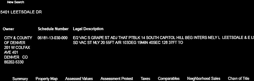


42 37


43 38
44 EXHIBIT D: AUTHORIZATION DOCUMENTS See authorization documents on the following pages. 39
45 2017I January 18,April 2019 fees waived , 2019 rev.; per feesdzc waived per DZC

46 US MONROE ILC.A COLORADO LIM1T60 LIABILITY COMPANY, AS TO PARCEL A, B & C State of Colorado County of ) )ss. ) t:.m.vif SUZANNE MUTCHLER Notary Public State of Colorado Notary My Commission.Expires Sep 26, 2018 The foregoing final affidavit and agreement was subscribed and aifirrned before me on this day of 1-\ 1-)'0''{7 ARNOLD AS MANAGER OF 226 MONROE ST, LLC, A COLORADO LIMITED LIABILITY COMPANY.w Notary Public My commission expires q \,- 2..o \ 41 by PAULA
47 226 MONROE STREET LLC 4466 Forest St. Denver, CO January 23, 2018 City & County of Denver Community Planning and Development Rezoning/Map Amendments 201 W. Colfax Ave., Dept. 201 Denver, CO To Whom It May Concern: This letter is to serve as authorization for Liz Adams and Peter Wall of CRL Associates, Inc. to act on behalf of 226 Monroe Street LLC and submit the Zone Map Amendment for the properties located at: 5231, , 5335 LEETSDALE DR 420,450 S. GRAPE ST Sincerely, Paula Arnold Manager 42

48 STATEMENT OF AUTHORITY ( , C.R.S.) I. This Statement of Authority relates to an entity named: Priddy's Auction Galleries, Inc. 2. The type ofentity is a corporation. 3. The entity is formed under the law of Colorado. 4. The mailing address for the entity is: 1293 S. Alton Ct. Denver, CO The name and position of each person authorized to execute instruments conveying, encumbering, or otherwise affecting title to real property on behalf of the entity is: Joseph G.E. Priddy President Priddy's Auction Galleries, Inc. 6. This Statement of Authority is executed on behalfof the entity pursuant to the provisions ofcolorado Revised Statute Section (2). Executed this?/ day of, Josep riddy, President Priddy s />;. ction Galleries, Inc. STATE ofcalbl"'jo COUNTY OF f:i QoSa ) ss. ) The foregoing instrument was acknowledged before me this Av9LK±, 20li'by <) US:-e ;;,h C:1, E. Pr,,\c,\ y 3 ls::t day of Witness my hand and official seal. My Commission Expires: Se-pt. '.);::z.010. ELIZABETH MIRELES NOTARY PUBLIC STATE OF COLORADO NOTARY ID MY COMMISSION EXPIRES SEPT

49 PRIDDY'S AUCTION GALLERIES, INC s. Alton Court Denver, Colorado July 7, 2018 City & County of Denver Community Planning and Development Rezoning/Map Amendments 201 W. Colfax Ave., Dept. 201 Denver, CO To Whom It May Concern: This letter is to serve as authorization for Liz Adams and Peter Wall ofcrl Associates, Inc. to act on behalf of Priddy's Auction Galleries, Inc. and submit the Zone Map Amendment for the property located at: 5409 and 5411 Leetsdale Dr. Sincerely, 44

50 January 15, 2019 Jeff Hirt Senior City Planner Community Planning and Development City and County of Denver Via Mr. Hirt: I am writing to you as the President for Priddy Auction Galleries, Inc., owner of the property located at 5409 Leetsdale Drive and 5411 Leetsdale Driver currently zoned as PUD 627 under Title 59 of the Denver Zoning Code. Priddy Auction Galleries, Inc. is aware the owner of the additional property zoned PUD 627, including 5231 Leetsdale Drive, Leetsdale Drive, 420 S. Grape Street and 450 S. Grape Street, would like to submit an application to rezone those parcels to E CC-3 under the Denver Zoning Code. As the authorized agent of Priddy Auction Galleries, Inc., ownership acknowledges and supports the rezoning application moving forward without the inclusion of our property. President Priddy Auction Galleries, Inc. 45

51 46
52 EXHIBIT E: ASSESSOR S PARCEL NUMBERS Given the number of parcels involved in this map amendment, the table on the following page shows the Accessor s schedule numbers, active address, assessor s address and owner of each property. To comply with Title 59 regarding PUD amendments, applicant has also included information on Deeds of Trust. 47
53 EXHIBIT E ASSESSOR'S PARCEL NUMBERS Property within proposed rezoning boundary Schedule Number Active Address S Grape Street S Grape Street Leetsdale Drive Leetsdale Drive Leetsdale Drive 5301, 5303, 5305, Leetsdale Drive Assessor Address 400 S Grape Street 400 S Grape Street 485 S Grape Street 5231 Leetsdale Drive 5301 Leetsdale Drive City Denver Denver Denver Denver Denver 5301 Leetsdale Drive 5307 Denver Other Property within PUD 627 not proposed to be rezoned Schedule Number Active Address Assessor Address Leetsdale Drive 5411 Leetsdale Drive Leetsdale Drive 5401 Leetsdale Drive Leetsdale Drive 5401 Leetsdale Drive Leetsdale Drive 5401 Leetsdale Drive City Denver Denver Denver Denver State CO CO CO CO CO Zip CO State CO CO CO CO Owner Name 226 Monroe Street LLC 226 Monroe Street LLC 226 Monroe Street LLC 226 Monroe Street LLC 226 Monroe Street LLC Owner Address 4466 Forest St. Denver, CO Forest St. Denver, CO Forest St. Denver, CO Forest St. Denver, CO Forest St. Denver, CO DEED OF TRUST Collegiate Peaks Bank Collegiate Peaks Bank Collegiate Peaks Bank Collegiate Peaks Bank Collegiate Peaks Bank Monroe Street LLC 4471 Forest St. Denver, CO Collegiate Peaks Bank Owner Address 1293 S Alton Ct, Denver, CO S Alton Ct, Denver, CO W. Colfax Avenue, Denver, CO W. Colfax Avenue, Denver, CO DEED OF TRUST Deed of Trust released Deed of Trust released Zip Owner Name Priddy's Auction Galleries Inc. Priddy's Auction Galleries Inc. City and County of Denver City and County of Denver 48
54 EXHIBIT F: MAP OF PROPERTY The map on the following page shows all the parcels zoned B3 Waivers and Conditions and PUD 627. Also shown is the parcel in PUD 627 that will not be included in the rezoning to E-CC-3. 49

55 EXHIBIT F PROPERTY TO BE REZONED FROM B3 Waivers and Conditions AND PUD 627 TO E-CC-3 B3 Waivers and Conditions 50
REZONING GUIDE. Zone Map Amendment (Rezoning) - Application. Rezoning Application Page 1 of 3. Return completed form to
 - Application. Rezoning Application Page 1 of 3. Return completed form to") Zone Map Amendment (Rezoning) - Application COMMUNITY PLANNING & DEVELOPMENT REZONING GUIDE Rezoning Application Page 1 of 3 PROPERTY OWNER INFORMATION* CHECK IF POINT OF CONTACT FOR APPLICATION Property
Zone Map Amendment (Rezoning) - Application COMMUNITY PLANNING & DEVELOPMENT REZONING GUIDE Rezoning Application Page 1 of 3 PROPERTY OWNER INFORMATION* CHECK IF POINT OF CONTACT FOR APPLICATION Property
REZONING GUIDE. Zone Map Amendment (Rezoning) - Application. Rezoning Application Page 1 of 3. Return completed form to
 - Application. Rezoning Application Page 1 of 3. Return completed form to") COMMUNITY PLANNING & DEVELOPMENT REZONING GUIDE Rezoning Application Page 1 of 3 Zone Map Amendment (Rezoning) - Application PROPERTY OWNER INFORMATION* PROPERTY OWNER(S) REPRESENTATIVE** CHECK IF POINT
COMMUNITY PLANNING & DEVELOPMENT REZONING GUIDE Rezoning Application Page 1 of 3 Zone Map Amendment (Rezoning) - Application PROPERTY OWNER INFORMATION* PROPERTY OWNER(S) REPRESENTATIVE** CHECK IF POINT
Representative Name. Address. City, State, Zip. Telephone.
 COMMUNITY PLANNING & DEVELOPMENT ~~DENVER... THE MILE HIGH CITY REZONING GUIDE Zone Map Amendment (Rezoning)- Application Rezoning Application Page 1 of 3 Property Owner Name Philip M. Falco Address 730
E-SU-A. Zone Map Amendment (Rezoning) -Application E-SU-B. Rf tum cornpleted form to rezoning(i:})denvergov.org. *If More Than One Property Owner;
 -Application E-SU-B. Rf tum cornpleted form to rezoning(i:})denvergov.org. *If More Than One Property Owner;") Zone Map Amendment (Rezoning) -Application Property Owner Name Philip M. Falco Representative Name Address 730 17th Street, Suite 900 Address City, State, Zip Denver, CO 80202 City, State, Zip Telephone
Zone Map Amendment (Rezoning) -Application Property Owner Name Philip M. Falco Representative Name Address 730 17th Street, Suite 900 Address City, State, Zip Denver, CO 80202 City, State, Zip Telephone
REZONING GUIDE. Zone Map Amendment (Rezoning) - Application. Rezoning Application Page 1 of 3. Return completed form to
 - Application. Rezoning Application Page 1 of 3. Return completed form to") COMMUNITY PLANNING & DEVELOPMENT REZONING GUIDE Rezoning Application Page 1 of 3 Zone Map Amendment (Rezoning) - Application PROPERTY OWNER INFORMATION* PROPERTY OWNER(S) REPRESENTATIVE** CHECK IF POINT
COMMUNITY PLANNING & DEVELOPMENT REZONING GUIDE Rezoning Application Page 1 of 3 Zone Map Amendment (Rezoning) - Application PROPERTY OWNER INFORMATION* PROPERTY OWNER(S) REPRESENTATIVE** CHECK IF POINT
REZONING GUIDE. Zone Map Amendment (Rezoning) - Application. Applicant: Albus Brooks, Councilman District 9
 - Application. Applicant: Albus Brooks, Councilman District 9") Zone Map Amendment (Rezoning) - Application COMMUNITY PLANNING & DEVELOPMENT REZONING GUIDE Rezoning Application Page 1 of 3 PROPERTY OWNER INFORMATION* CHECK IF POINT OF CONTACT FOR APPLICATION Property
Zone Map Amendment (Rezoning) - Application COMMUNITY PLANNING & DEVELOPMENT REZONING GUIDE Rezoning Application Page 1 of 3 PROPERTY OWNER INFORMATION* CHECK IF POINT OF CONTACT FOR APPLICATION Property
REZONING GUIDE. Zone Map Amendment (Rezoning) - Application. Rezoning Application Page 1 of 3. Return completed form to
 - Application. Rezoning Application Page 1 of 3. Return completed form to") Zone Map Amendment (Rezoning) - Application COMMUNITY PLANNING & DEVELOPMENT REZONING GUIDE Rezoning Application Page 1 of 3 PROPERTY OWNER INFORMATION* CHECK IF POINT OF CONTACT FOR APPLICATION Property
Zone Map Amendment (Rezoning) - Application COMMUNITY PLANNING & DEVELOPMENT REZONING GUIDE Rezoning Application Page 1 of 3 PROPERTY OWNER INFORMATION* CHECK IF POINT OF CONTACT FOR APPLICATION Property
REZONING GUIDE. Zone Map Amendment (Rezoning) - Application. Rezoning Application Page 1 of 3. Return completed form to
 - Application. Rezoning Application Page 1 of 3. Return completed form to") Zone Map Amendment (Rezoning) - Application COMMUNITY PLANNING & DEVELOPMENT REZONING GUIDE Rezoning Application Page 1 of 3 PROPERTY OWNER INFORMATION* CHECK IF POINT OF CONTACT FOR APPLICATION Property
Zone Map Amendment (Rezoning) - Application COMMUNITY PLANNING & DEVELOPMENT REZONING GUIDE Rezoning Application Page 1 of 3 PROPERTY OWNER INFORMATION* CHECK IF POINT OF CONTACT FOR APPLICATION Property
Telephone AC / 21,960 SF G-MU-3 G-MX-3
 Zone Map Amendment (Rezoning) - Application PROPERTY OWNER INFORMATION* CHECK IF POINT OF CONTACT FOR APPLICATION Property Owner Name Siddhartha Rathod Address City, State, Zip Telephone Email COMMUNITY
Zone Map Amendment (Rezoning) for PUD - Application York St. U-MX-3, B-2 with Waivers. General PUD. Yes. See Attachment C U-MX-3, I-MX-3
 for PUD - Application York St. U-MX-3, B-2 with Waivers. General PUD. Yes. See Attachment C U-MX-3, I-MX-3") COMMUNITY PLANNING & DEVELOPMENT REZONING GUIDE Rezoning Application for PUD Page 1 of 3 Zone Map Amendment (Rezoning) for PUD - Application PROPERTY OWNER INFORMATION* CHECK IF POINT OF CONTACT FOR APPLICATION
COMMUNITY PLANNING & DEVELOPMENT REZONING GUIDE Rezoning Application for PUD Page 1 of 3 Zone Map Amendment (Rezoning) for PUD - Application PROPERTY OWNER INFORMATION* CHECK IF POINT OF CONTACT FOR APPLICATION
Block bounded by Newton St., 17 th Ave., Lowell Blvd., and 16 th Ave.; plus Meade Street (evens only)
") Community Planning and Development Planning Services 201 W. Colfax Ave., Dept. 205 Denver, CO 80202 p: 720.865.2915 f: 720.865.3052 www.denvergov.org/cpd TO: Denver Planning Board FROM: Sara White, AICP,
Community Planning and Development Planning Services 201 W. Colfax Ave., Dept. 205 Denver, CO 80202 p: 720.865.2915 f: 720.865.3052 www.denvergov.org/cpd TO: Denver Planning Board FROM: Sara White, AICP,
E-SU-A. Zone Map Amendment (Rezoning) -Application E-SU-B. Rf tum cornpleted form to rezoning(i:})denvergov.org. *If More Than One Property Owner;
 -Application E-SU-B. Rf tum cornpleted form to rezoning(i:})denvergov.org. *If More Than One Property Owner;") Zone Map Amendment (Rezoning) -Application Property Owner Name Philip M. Falco Representative Name Address 730 17th Street, Suite 900 Address City, State, Zip Denver, CO 80202 City, State, Zip Telephone
Zone Map Amendment (Rezoning) -Application Property Owner Name Philip M. Falco Representative Name Address 730 17th Street, Suite 900 Address City, State, Zip Denver, CO 80202 City, State, Zip Telephone
Official Zoning Map Amendment Application #2017I and 4889 South Quebec Street Rezoning from B-4 with waivers, UO-1, UO-2 to C-MX-20
 Community Planning and Development Planning Services 201 W. Colfax Ave., Dept. 205 Denver, CO 80202 p: 720.865.2915 f: 720.865.3052 www.denvergov.org/cpd TO: Denver Planning Board FROM: Jeff Hirt, Senior
Land Use, Transportation, and Infrastructure Committee of Denver City Council FROM: Scott Robinson, Senior City Planner DATE: December 6, 2018 RE:
 Community Planning and Development Planning Services 201 W. Colfax Ave., Dept. 205 Denver, CO 80202 p: 720.865.2915 f: 720.865.3052 www.denvergov.org/cpd TO: Land Use, Transportation, and Infrastructure
Staff Report and Recommendation Based on the criteria for review in the Denver Zoning Code, Staff recommends approval for application #2017I
 TO: Denver City Council, Land Use, Transportation and Infrastructure Committee FROM: Theresa Lucero, Senior City Planner DATE: RE: Official Zoning Map Amendment Application #2017I-00153 Staff Report and
Land Use, Transportation, and Infrastructure Committee of the Denver City Council FROM: Scott Robinson, Senior City Planner DATE: March 22, 2018 RE:
 Community Planning and Development Planning Services 201 W. Colfax Ave., Dept. 205 Denver, CO 80202 p: 720.865.2915 f: 720.865.3052 www.denvergov.org/cpd TO: Land Use, Transportation, and Infrastructure
Official Zoning Map Amendment Application #2018I-00095
 Community Planning and Development Planning Services 201 W. Colfax Ave., Dept. 205 Denver, CO 80202 p: 720.865.2915 f: 720.865.3052 www.denvergov.org/cpd TO: Denver Planning Board FROM: Ella Stueve, Senior
Staff Report and Recommendation Based on the criteria for review in the Denver Zoning Code, Staff recommends approval for Application #2017I
 TO: Denver Planning Board, Joel Noble, Chair FROM: Theresa Lucero, Senior City Planner DATE: RE: Official Zoning Map Amendment Application #2017I-00163 Staff Report and Recommendation Based on the criteria
Article 3. SUBURBAN (S-) NEIGHBORHOOD CONTEXT
 NEIGHBORHOOD CONTEXT") Article 3. SUBURBAN (S-) NEIGHBORHOOD CONTEXT this page left intentionally blank Contents ARTICLE 3. SUBURBAN (S-) NEIGHBORHOOD CONTEXT DIVISION 3.1 NEIGHBORHOOD CONTEXT DESCRIPTION...3.1-1 Section 3.1.1
Article 3. SUBURBAN (S-) NEIGHBORHOOD CONTEXT this page left intentionally blank Contents ARTICLE 3. SUBURBAN (S-) NEIGHBORHOOD CONTEXT DIVISION 3.1 NEIGHBORHOOD CONTEXT DESCRIPTION...3.1-1 Section 3.1.1
ARTICLE 3: Zone Districts
 ARTICLE 3: Zone Districts... 3-1 17.3.1: General...3-1 17.3.1.1: Purpose and Intent... 3-1 17.3.2: Districts and Maps...3-1 17.3.2.1: Applicability... 3-1 17.3.2.2: Creation of Districts... 3-1 17.3.2.3:
Public Review of the Slot Home Text Amendment
 Public Review of the Slot Home Text Amendment The proposed amendments to the Denver Zoning Code have been informed by the Slot Home Strategy Report. This document has been developed out of a robust process
Request for Rezoning. Current Zoning: Proposed Zoning:
 TO: Denver City Council, Neighborhoods and Planning Committee FROM: Theresa Lucero, Senior City Planner DATE: March 31, 2016 RE: Zoning Map Amendment #2015I-00150 Rezoning from M-RX-5 to I-MX-3 Community
REZONING GUIDE. Zone Map Amendment (Rezoning) - Application. Rezoning Application Page 1 of 3. Return completed form to
 - Application. Rezoning Application Page 1 of 3. Return completed form to") COMMUNITY PLANNING & DEVELOPMENT REZONING GUIDE Rezoning Application Page 1 of 3 Zone Map Amendment (Rezoning) - Application PROPERTY OWNER INFORMATION* PROPERTY OWNER(S) REPRESENTATIVE** CHECK IF POINT
COMMUNITY PLANNING & DEVELOPMENT REZONING GUIDE Rezoning Application Page 1 of 3 Zone Map Amendment (Rezoning) - Application PROPERTY OWNER INFORMATION* PROPERTY OWNER(S) REPRESENTATIVE** CHECK IF POINT
2018I June 25, 2018 $1000 fee pd chk
 2018I-00050 June 25, 2018 $1000 fee pd chk 2018I-00050 June 25, 2018 $1000 fee pd chk 2018I-00050 June 25, 2018 $1000 fee pd chk 2018I-00050 June 25, 2018 $1000 fee pd chk Legal Description of Property
2017I September 7, 2018 fees waived per
 Review Criteria for 3610 and 3612 North Clay Street from PUD #504 to U-TU-B. 1. Consistency with Adopted Plans: The following adopted plans apply to this property: Denver Comprehensive Plan 2000 Blueprint
Official Zoning Map Amendment Application #2017I-00094
 Community Planning and Development Planning Services 201 W. Colfax Ave., Dept. 205 Denver, CO 80202 p: 720.865.2915 f: 720.865.3052 www.denvergov.org/cpd TO: Denver Planning Board FROM: Scott Robinson,
Official Zoning Map Amendment Application #2015I Marion St. Rezoning from U-SU-A1 to U-MX-2x
 Community Planning and Development Planning Services 201 W. Colfax Ave., Dept. 205 Denver, CO 80202 p: 720.865.2915 f: 720.865.3052 www.denvergov.org/cpd TO: Denver City Council FROM: Courtland Hyser,
Official Zoning Map Amendment Application #2017I Gaylord Street and York Street Rezoning from U-RH-2.5 to U-RX-3 and U-RX-5
 Community Planning and Development Planning Services 201 W. Colfax Ave., Dept. 205 Denver, CO 80202 p: 720.865.2915 f: 720.865.3052 www.denvergov.org/cpd TO: Denver Planning Board FROM: Elizabeth Weigle,
To: S-MX-8 AIO, S-MX-8A AIO, S-MX-12 AIO, C-MX-8 AIO, C-MX-12 AIO, and S-CC-5 AIO
 Community Planning and Development Planning Services 201 W. Colfax Ave., Dept. 205 Denver, CO 80202 p: 720.865.2915 f: 720.865.3052 www.denvergov.org/cpd TO: Denver City Council FROM: Curt Upton, Senior
Official Zoning Map Amendment Application #2018I-00120
 Community Planning and Development Planning Services 201 W. Colfax Ave., Dept. 205 Denver, CO 80202 p: 720.865.2915 f: 720.865.3052 www.denvergov.org/cpd TO: Denver Planning Board FROM: Scott Robinson,
Official Zoning Map Amendment Application #2018I-00067
 Community Planning and Development Planning Services 201 W. Colfax Ave., Dept. 205 Denver, CO 80202 p: 720.865.2915 f: 720.865.3052 www.denvergov.org/cpd TO: Denver Planning Board FROM: Courtney Levingston,
Official Zoning Map Amendment Application #2017I-00090
 Community Planning and Development Planning Services 201 W. Colfax Ave., Dept. 205 Denver, CO 80202 p: 720.865.2915 f: 720.865.3052 www.denvergov.org/cpd TO: Land Use, Transportation, & Infrastructure
PLANNING COMMISSION STAFF REPORT
 PLANNING COMMISSION STAFF REPORT West Capitol Hill Zoning Map Amendment Petition No. PLNPCM2011-00665 Located approximately at 548 W 300 North Street, 543 W 400 North Street, and 375 N 500 West Street
Reviewing Mixed Use Proposals
 MIXED USE ZONING Citizens Guide Supplement 1 Things to Consider in Reviewing Mixed Use Proposals Using an Overlay District vs. Changing Underlying Zoning To achieve well-planned mixed use development,
PARRAMORE OAKS FRAMEWORK PLANNED DEVELOPMENT
 PARRAMORE OAKS FRAMEWORK PLANNED DEVELOPMENT Presented by Mark Cechman, AICP Paul S. Lewis, FAICP Review Process Pre- Application meeting August 11, 2016 Attended by representatives of: City Planning Transportation
Bylaw No , being "Official Community Plan Bylaw, 2016" Schedule "A" DRAFT
 Bylaw No. 2600-2016, being "Official Community Plan Bylaw, 2016" Schedule "A" Urban Structure + Growth Plan Urban Structure Land use and growth management are among the most powerful policy tools at the
Brad Buchanan, Executive Director, Department of Community Planning and Development
 TO: City Council FROM: Jeff Hirt, Senior City Planner DATE: RE: Official Zoning Map Amendment Application #2017I-00076 3400 Arkins Ct., 3460 Arkins Ct., 1900 35 th St, 1930 35th St., 1950 35 th St Rezoning
Official Zoning Map Amendment Application #2015I N. King Street and 3441 W. 39 th Ave Rezoning from PUD 406 to U-SU-B1
 Community Planning and Development Planning Services 201 W. Colfax Ave., Dept. 205 Denver, CO 80202 p: 720.865.2915 f: 720.865.3052 www.denvergov.org/cpd TO: Neighborhoods and Planning Committee FROM:
PLANNING COMMISSION STAFF REPORT
 PLANNING COMMISSION STAFF REPORT REZONING CASE: RZ-16-001 REPORT DATE: March 8, 2016 CASE NAME: Trailbreak Partners Rezoning PLANNING COMMISSION DATE: March 16, 2016 ADDRESSES OF REZONING PROPOSAL: 5501
DZC and DRMC Amendments to Implement 38th and Blake Station Area Height Amendments
 DZC and DRMC Amendments to Implement 38th and Blake Station Area Height Amendments DZC Text Amendment #2 to establish River North Design Overlay (DO-7) / 38 th and Blake Incentive Overlay (IO-1) (CB18-0016)
Poughkeepsie City Center Revitalization Plan
 Purpose and Need Purpose Increase job and educational opportunities for all residents Maximize fiscal productivity of downtown land uses Diversify retail mix Eliminate surface and building vacancies Create
Town of Yucca Valley GENERAL PLAN 1
 Town of Yucca Valley GENERAL PLAN 1 This page intentionally left blank. 3 HOUSING ELEMENT The Housing Element is intended to guide residential development and preservation consistent with the overall values
HOUSING ELEMENT GOALS, OBJECTIVES, & POLICIES
 HOUSING ELEMENT GOALS, OBJECTIVES, & POLICIES GOAL H-1: ENSURE THE PROVISION OF SAFE, AFFORDABLE, AND ADEQUATE HOUSING FOR ALL CURRENT AND FUTURE RESIDENTS OF WALTON COUNTY. Objective H-1.1: Develop a
HOUSING ELEMENT GOALS, OBJECTIVES, AND POLICIES
 HOUSING ELEMENT GOALS, OBJECTIVES, AND POLICIES GOAL 1: To promote the preservation and development of high-quality, balanced, and diverse housing options for persons of all income levels throughout the
Appendix A: Guide to Zoning Categories Prince George's County, Maryland
 Appendix A: Guide to Zoning Categories Prince George's County, Maryland RESIDENTIAL ZONES 1 Updated November 2010 R-O-S: Reserved Open Space - Provides for permanent maintenance of certain areas of land
Article 6. GENERAL URBAN (G-) NEIGHBORHOOD CONTEXT
 NEIGHBORHOOD CONTEXT") Article 6. GENERAL URBAN (G-) NEIGHBORHOOD CONTEXT this page left intentionally blank Contents ARTICLE 6. GENERAL URBAN (G-) NEIGHBORHOOD CONTEXT DIVISION 6.1 NEIGHBORHOOD CONTEXT DESCRIPTION...6.1-1 Section
Article 6. GENERAL URBAN (G-) NEIGHBORHOOD CONTEXT this page left intentionally blank Contents ARTICLE 6. GENERAL URBAN (G-) NEIGHBORHOOD CONTEXT DIVISION 6.1 NEIGHBORHOOD CONTEXT DESCRIPTION...6.1-1 Section
CITY OF FARMERSVILLE CITIZEN ADVISORY COMMITTEE AGENDA November 17, :30 P.M. 1, COUNCIL CHAMBERS, CITY HALL
 I. PRELIMINARY MATTERS CITY OF FARMERSVILLE CITIZEN ADVISORY COMMITTEE AGENDA November 17, 2014 6:30 P.M. 1, COUNCIL CHAMBERS, CITY HALL Call to Order, Roll Call, Prayer and Pledge of Allegiance Welcome
8/17/16 PC Meeting 1
 1 GENERAL INFORMATION OWNER/APPLICANT: Thomas Corff & Terry Moberly (1943 13 th St.) 19328 Towercrest Dr. Oregon City, OR 97045 Michael & Jill Parker (1983 13 th St.) 1708 Oak St. Lake Oswego, OR 97034
Salem HNA and EOA Advisory Committee Meeting #6
 Salem HNA and EOA Advisory Committee Meeting #6 Residential Land Policies Employment Land Policies Policy Discussions with the Committee Outcome of today s meeting Direction from this Committee on proposed
PLANNED UNIT DEVELOPMENT & SUBDIVISION STAFF REPORT Date: April 18, 2019
 PLANNED UNIT DEVELOPMENT & SUBDIVISION STAFF REPORT Date: April 18, 2019 DEVELOPMENT NAME SUBDIVISION NAME Springhill Village Subdivision Springhill Village Subdivision LOCATION 4350, 4354, 4356, 4358,
Ann Arbor Downtown Zoning Evaluation
 Ann Arbor Downtown Zoning Evaluation Options Workbook ENP & Associates in cooperation with the City of Ann Arbor September, 2013 Photo Courtesy of Andrew Horne, February 9, 2013 Introduction Thank you
Land Use, Transportation, & Infrastructure Committee of the Denver City Council FROM: Chandler Van Schaack, Senior City Planner DATE: July 3, 2018 RE:
 Community Planning and Development Planning Services TO: Land Use, Transportation, & Infrastructure Committee of the Denver City Council FROM: Chandler Van Schaack, Senior City Planner DATE: July 3, 2018
LITTLE MOUNTAIN ADJACENT AREA REZONING POLICY
 LITTLE MOUNTAIN ADJACENT AREA REZONING POLICY JANUARY 2013 CONTENTS 1.0 INTENT & PRINCIPLES...1 2.0 APPLICATION...2 3.0 HOUSING TYPES, HEIGHT & DENSITY POLICIES...3 3.1 LOW TO MID-RISE APARTMENT POLICIES...4
GENERAL DESCRIPTION STAFF RECOMMENDATION IMPLEMENTATION REQUIREMENTS
 Application No.: 891418 Applicant: AREA-WIDE MAP AMENDMENT Rezone two parcels from Moderate Density Single Family (MSF) to Neighborhood Center (NC) and Employment Center (EC). Charles Bitton GENERAL DESCRIPTION
Twin Cities Region Equitable Development Principles & Scorecard
 Twin Cities Region Equitable Development Principles & Scorecard a tool for communities and planners June 2014 Created by Community Engagement Steering Committee Equitable Development working group: Asian
REZONING GUIDE. Zone Map Amendment (Rezoning) - Application. Rezoning Application Page 1 of 3. Return completed form to
 - Application. Rezoning Application Page 1 of 3. Return completed form to") COMMUNITY PLANNING & DEVELOPMENT REZONING GUIDE Rezoning Application Page 1 of 3 Zone Map Amendment (Rezoning) - Application PROPERTY OWNER INFORMATION* PROPERTY OWNER(S) REPRESENTATIVE** CHECK IF POINT
COMMUNITY PLANNING & DEVELOPMENT REZONING GUIDE Rezoning Application Page 1 of 3 Zone Map Amendment (Rezoning) - Application PROPERTY OWNER INFORMATION* PROPERTY OWNER(S) REPRESENTATIVE** CHECK IF POINT
Based on the criteria for review in the Denver Zoning Code, Staff recommends approval for Application #2018I
 Community Planning and Development Planning Services 201 W. Colfax Ave., Dept. 205 Denver, CO 80202 p: 720.865.2915 f: 720.865.3052 www.denvergov.org/cpd TO: Denver Planning Board FROM: Chandler Van Schaack,
Attachment I is an updated memo from Pat Comarell, providing the updated balancing tests to reflect the Council s October 10 th briefing.
 COUNCIL STAFF REPORT CITY COUNCIL of SALT LAKE CITY TO: City Council Members FROM: Ben Luedtke & Nick Tarbet Policy Analysts DATE: October 17, 2017 RE: Housing Plan: Growing Salt Lake PLNPCM2017-00168
Bridgeland-Riverside Area Redevelopment Plan (ARP)
") Bridgeland-Riverside Area Redevelopment Plan (ARP) The current Bridgeland-Riverside Area Redevelopment Plan (ARP) was approved in 1980. Since then, a lot of changes have taken place in the city and the
Bridgeland-Riverside Area Redevelopment Plan (ARP) The current Bridgeland-Riverside Area Redevelopment Plan (ARP) was approved in 1980. Since then, a lot of changes have taken place in the city and the
DRAFT FOR DISCUSSION PURPOSES ONLY. Port Credit Local Area Plan Built Form Guidelines and Standards DRAFT For Discussion Purposes
 Port Credit Local Area Plan Built Form Guidelines and Standards DRAFT For Discussion Purposes 1 Local Area Plan - Project Alignment Overview Directions Report, October 2008 (General Summary Of Selected
DIVISION 1.3 OFFICIAL ZONING MAP
 Article 1. General Provisions Division 1.3 Official Zone Map DIVISION 1.3 OFFICIAL ZONING MAP SECTION 1.3.1 ADOPTION OF OFFICIAL MAP The digital maps created and maintained by the Department of Community
Staff Report and Recommendation
 Community Planning and Development Planning Services 201 W. Colfax Ave., Dept. 205 Denver, CO 80202 p: 720.865.2915 f: 720.865.3052 www.denvergov.org/cpd TO: Denver Planning Board FROM: Andrew Webb, Senior
Nassau County 2030 Comprehensive Plan. Housing Element (H) Goals, Objectives and Policies. Goal
 Goals, Objectives and Policies. Goal") (H) Goal Assist the private sector to provide and maintain an adequate inventory of decent, safe and sanitary housing in suitable neighborhoods at affordable costs to meet the need of the present and future
(H) Goal Assist the private sector to provide and maintain an adequate inventory of decent, safe and sanitary housing in suitable neighborhoods at affordable costs to meet the need of the present and future
13 Sectional Map Amendment
 13 Sectional Map Amendment Introduction This chapter reviews land use and zoning policies and practices in Prince George s County and presents the proposed zoning in the sectional map amendment (SMA) to
MONTGOMERY COUNTY RENTAL HOUSING STUDY. NEIGHBORHOOD ASSESSMENT June 2016
 MONTGOMERY COUNTY RENTAL HOUSING STUDY NEIGHBORHOOD ASSESSMENT June 2016 AGENDA Model Neighborhood Presentation Neighborhood Discussion Timeline Discussion Next Steps 2 WORK COMPLETED Socioeconomic Analysis
this page left intentionally blank DENVER ZONING CODE
 Article 1. GENERAL PROVISIONS this page left intentionally blank Contents ARTICLE 1. GENERAL PROVISIONS DIVISION 1.1 GENERAL...1.1-1 Section 1.1.1 Purpose...1.1-1 Section 1.1.2 Intent...1.1-1 Section 1.1.3
Chapter 10: Implementation
 Chapter 10: Introduction Once the Comprehensive Plan has been adopted by the City of Oakdale, the City can begin to implement the goals and strategies to make this vision a reality. This chapter will set
Rapid City Planning Commission Rezoning Project Report
 Rapid City Planning Commission Rezoning Project Report April 21, 2016 Item #9 Applicant Request(s) Case # 16RZ011; a request to rezone property from Central Business District to General Commercial District
Hennepin County Department of. Housing, Community Works and Transit. Transit Oriented Development (TOD) Guidelines
 Guidelines") Hennepin County Department of Housing, Community Works and Transit 2007 Transit Oriented Development (TOD) Guidelines Hennepin County Transit Oriented Development (TOD) Bond Funds Hennepin County Housing,
Hennepin County Department of Housing, Community Works and Transit 2007 Transit Oriented Development (TOD) Guidelines Hennepin County Transit Oriented Development (TOD) Bond Funds Hennepin County Housing,
Denver City Council Land Use, Transportation, and Infrastructure Committee FROM: Courtney Levingston, Senior City Planner DATE: July 26, 2018 RE:
 TO: Denver City Council Land Use, Transportation, and Infrastructure Committee FROM: Courtney Levingston, Senior City Planner DATE: RE: Official Zoning Map Amendment Application #2017I-00151 Staff Report
Generic Environmental Impact Statement. Build-Out Analysis. City of Buffalo, New York. Prepared by:
 Generic Environmental Impact Statement Build-Out Analysis City of Buffalo, New York 2015 Prepared by: TABLE OF CONTENTS 1.0 INTRODUCTION 1 2.0 METHODOLOGY 2 3.0 EXISTING LAND USE 3 4.0 EXISTING ZONING
An Introduction to the City of Winnipeg s New Zoning By-Law
 An Introduction to the City of Winnipeg s New Zoning By-Law Presentation To: APEGM PIDIM MAA April 30, 2008 1 The Planning Hierarchy Plan Winnipeg s Primary Purpose: To ensure that the use and development
PLANNING COMMISSION WILLIAMSBURG, VIRGINIA WORK SESSION AGENDA Wednesday, May 23, 2012
 PLANNING COMMISSION WILLIAMSBURG, VIRGINIA WORK SESSION AGENDA Wednesday, May 23, 2012 The meeting will be called to order in the third floor Conference Room (Room 310), Williamsburg Municipal Building,
Summary. Draft Redevelopment Plan Summary Flowery Branch Tax Allocation District # 1:
 Summary Draft Redevelopment Plan Summary Flowery Branch Tax Allocation District # 1: Flowery Branch Tax Allocation District Old Town and Commercial Gateways 1 Public Hearing Presentation November 21, 2007
TOD: Types of Capital Investment
 TOD Finance and M&E TOD: Types of Capital Investment When considering financing strategies for TOD corridor development, what needs to be financed? Transit Infrastructure Street Infrastructure & Public
REGULATING PLAN for the Plaza Saltillo TOD Station Area Plan (SAP)
") REGULATING PLAN for the Plaza Saltillo TOD Station Area Plan (SAP) Adopted: December 11, 2008 Effective: March 1, 2009 REGULATING PLAN for the Plaza Saltillo TOD Station Area Plan (SAP) CONTENTS BACKGROUND...iv
REGULATING PLAN for the Plaza Saltillo TOD Station Area Plan (SAP) Adopted: December 11, 2008 Effective: March 1, 2009 REGULATING PLAN for the Plaza Saltillo TOD Station Area Plan (SAP) CONTENTS BACKGROUND...iv
City of Winnipeg Housing Policy Implementation Plan
 The City of Winnipeg s updated housing policy is aligned around four major priorities. These priorities are highlighted below: 1. Targeted Development - Encourage new housing development that: a. Creates
Indicates Council-recommended changes Introduced by: Mr. Tackett Date of introduction: June 14, 2016 SUBSTITUTE NO. 1 TO ORDINANCE NO.
 Indicates Council-recommended changes Introduced by: Mr. Tackett Date of introduction: June 14, 2016 SUBSTITUTE NO. 1 TO ORDINANCE NO. 16-067 TO AMEND NEW CASTLE COUNTY CODE CHAPTER 40 (ALSO KNOWN AS THE
Rule 80. Preservation of Primary Agricultural Soils Revised and approved by the Land Use Panel during its public meeting on January 31, 2006.
 Rule 80. Preservation of Primary Agricultural Soils Revised and approved by the Land Use Panel during its public meeting on January 31, 2006. (A) Purpose. In accordance with 10 V.S.A. Sections 6025(b)
TOD and Equity. TOD Working Group. James Carras Carras Community Investment, Inc. August 7, 2015
 TOD and Equity TOD Working Group James Carras Carras Community Investment, Inc. August 7, 2015 What is Equitable TOD? Equity is fair and just inclusion. Equitable TOD is the precept that investments in
SUBDIVISION, PLANNED UNIT DEVELOPMENT, ZONING AMENDMENT, & SIDEWALK WAIVER STAFF REPORT Date: July 19, 2018
 SUBDIVISION, PLANNED UNIT DEVELOPMENT, ZONING AMENDMENT, & SIDEWALK WAIVER STAFF REPORT Date: July 19, 2018 NAME SUBDIVISION NAME LOCATION West Mobile Properties, LLC U.S. Machine Subdivision 556, 566,
H-POLICY 1: Preserve and improve existing neighborhoods. Ensure that Prince William County achieves new neighborhoods with a high quality of life.
 HOUSING Intent The intent of the Housing Plan is to provide a framework for providing for the housing needs of all residents of Prince William County. These needs are expressed in terms of quality, affordability,
Downtown Development Focus Area: I. Existing Conditions
 Downtown Development Focus Area: I. Existing Conditions The Downtown Development Focus Area is situated along Route 1, south of the train tracks, except for the existing Unilever property. It extends west
Charlottesville Planning Commission, Neighborhood Associations & News Media
 CITY OF CHARLOTTESVILLE A World Class City Department of Neighborhood Development Services City Hall Post Office Box 911 Charlottesville, Virginia 22902 Telephone 434-970-3182 Fax 434-970-3359 www.charlottesville.org
AGENDA SLOT HOME EVALUATION & TEXT AMENDMENT. 5:30 - Welcome
 AGENDA 5:30 - Welcome Please sign-in, put a sticker on the map, grab snacks, materials and a seat 5:45 - Staff Presentation 6:15 - Open House Stations Background Information Mixed Use Districts Multi Unit
FUTURE LAND USE. City of St. Augustine Comprehensive Plan EAR-Based Amendments
 FUTURE LAND USE City of St. Augustine Comprehensive Plan EAR-Based Amendments Future Land Use Element FLU Goal To create an environment within the City and adjacent areas in which its residents have the
Attachment 4. Planning Commission Staff Report. June 26, 2017
 Planning Commission Staff Report June 26, 2017 Agenda #: Regular Agenda - 2 Title: Applicant: Request: Location: Existing Zoning: Proposed Use: Staff Planner: The Brands and The Brands West Eagle Crossing
MODERATE INCOME RENTAL HOUSING PILOT PROGRAM: APPLICATION PROCESS, PROJECT REQUIREMENTS AND AVAILABLE INCENTIVES
 PAGE 1 OF 10 Planning - By-law Administration Bulletins Planning and Development Services, 453 W. 12th Ave Vancouver, BC V5Y 1V4 Φ 604.873.7000 fax 604.873.7060 planning@vancouver.ca MODERATE INCOME RENTAL
David J. Gellner, AICP, Principal Planner; (801) ; Zoning Map Amendment
 ; Zoning Map Amendment") Staff Report PLANNING DIVISION DEPARTMENT of COMMUNITY and NEIGHBORHOODS To: From: Salt Lake City Planning Commission David J. Gellner, AICP, Principal Planner; (801) 535-6107; david.gellner@slcgov.com
Staff Report PLANNING DIVISION DEPARTMENT of COMMUNITY and NEIGHBORHOODS To: From: Salt Lake City Planning Commission David J. Gellner, AICP, Principal Planner; (801) 535-6107; david.gellner@slcgov.com
Pierce County Comprehensive Plan Review
 2015-2016 Pierce County Comprehensive Plan Review March 16, 2016 Introduction Planning and Management Policies Some of the policies governing both the planning and management of growth and change within
b. providing adequate sites for new residential development
 DIVISION 2.200 SECTION 2.201 INTRODUCTION A. Purpose The purpose of the Housing Element is to establish the goal, objectives, and policies to guide housing development within Polk County over the next
TRANSIT-ORIENTED DEVELOPMENT PLAN PRESENTATION LAWRENCE TO BRYN MAWR MODERNIZATION PROJECT AREA
 TRANSIT-ORIENTED DEVELOPMENT PLAN PRESENTATION LAWRENCE TO BRYN MAWR MODERNIZATION PROJECT AREA Purpose Create a community-led vision for redevelopment in the neighborhood Test specific concepts for CTA
ATTACHMENT #1 SUMMARY CHART
 ATTACHMENT #1 SUMMARY CHART Item # Amendment To: Nature of Proposed Amendment PCM201801 PCM201802 PCM201803 PCM201804 LMA201802 LMA201803 LMA201804 PCT201801 PCT201802 PCT201803 FUTURE LAND USE MAP Parkway
MEMORANDUM Planning Commission Travis Parker, Planning Director DATE: April 4, 2018 Lakewood Zoning Amendments Housing and Mixed Use
 MEMORANDUM TO: FROM: Travis Parker, Planning Director DATE: April 4, 2018 SUBJECT: Lakewood Zoning Amendments Housing and Mixed Use In August 2017, the Lakewood Development Dialogue process began with
Comprehensive Plan Amendment #PLN , Reserve at Cannon Branch (Coles Magisterial District)
") COUNTY OF PRINCE WILLIAM 5 County Complex Court, Prince William, Virginia 22192-9201 PLANNING (703) 792-7615 FAX (703) 792-4758 OFFICE Internet www.pwcgov.org Christopher M. Price, AICP Director of Planning
COUNTY OF PRINCE WILLIAM 5 County Complex Court, Prince William, Virginia 22192-9201 PLANNING (703) 792-7615 FAX (703) 792-4758 OFFICE Internet www.pwcgov.org Christopher M. Price, AICP Director of Planning
DRAFT. Amendment to the Master Plan Land Use Element for Block 5002, Lot Township of Teaneck, Bergen County, New Jersey.
 DRAFT Amendment to the Master Plan Land Use Element for Block 5002, Lot 18.01 Township of Teaneck, Bergen County, New Jersey Prepared for: Township of Teaneck Planning Board Prepared by: Janice Talley,
PC Staff Report 11/18/2013 Z Item No. 1-1
 Z-13-00401 Item No. 1-1 PLANNING COMMISSION REPORT Regular Agenda - Public Hearing Item PC Staff Report 11/18/2013 ITEM NO. 1: Z-13-00401 IG (General Industrial) District TO CS (Strip Commercial) District;
Staff Report PLANNING DIVISION COMMUNITY & ECONOMIC DEVELOPMENT. Alley Closure
 Staff Report PLANNING DIVISION COMMUNITY & ECONOMIC DEVELOPMENT To: From: Salt Lake City Planning Commission Doug Dansie, 801-535-6182, doug.dansie@slcgov.com Date: March 23, 2016 Re: PLNPCM2015-00941
DRAFT Plan Incentives. Part A: Basic Discount
 DRAFT 2030 Plan Incentives July 26, 2006 Part A: Basic Discount In order for a development to be eligible for any 2030 Land Resource Management Plan Discounts it must be located in the Urban Corridor and