Brad Buchanan, Executive Director, Department of Community Planning and Development
|
|
|
- Ross Anthony
- 5 years ago
- Views:
Transcription
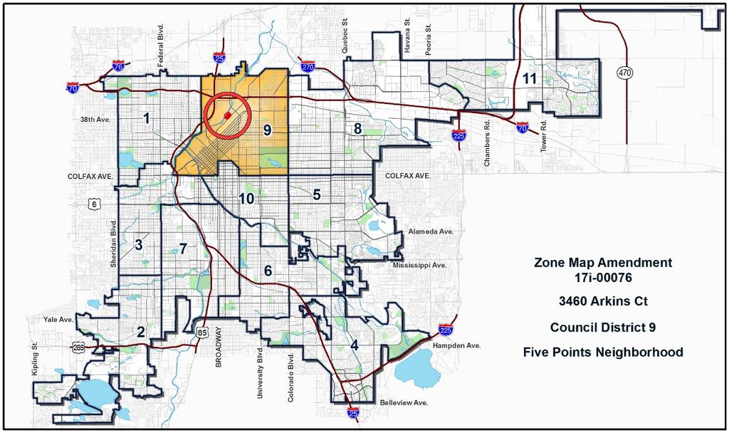
1 TO: City Council FROM: Jeff Hirt, Senior City Planner DATE: RE: Official Zoning Map Amendment Application #2017I Arkins Ct., 3460 Arkins Ct., th St, th St., th St Rezoning from I-MX-5, UO-2 to OS-A Community Planning and Development Planning Services 201 W. Colfax Ave., Dept. 205 Denver, CO p: f: Staff Report and Recommendation Based on the criteria for review in the Denver Zoning Code, Staff recommends approval for Application #2017I for a rezoning from I-MX-5, UO-2 to OS-A. Request for Rezoning Application: #2017I Address: 3400 Arkins Ct., 3460 Arkins Ct., th St., th St., th St. Neighborhood/Council District: Five Points / Council District 9 RNOs: Inter-Neighborhood Cooperation (INC), RiNo Art District, UCAN, Globeville Civic Association #2, Globeville Civic Partners, Elyria Swansea/Globeville Business Association, Globeville K.A.R.E.S., Rio Norte, Denver Arts and Culture Initiative, Comunidades Unidades, Globeville Elyria & Swansea, North Neighborhoods Democratic Council Area of Properties: 138,663 SF (3.2 acres) Current Zoning: I-MX-5, UO-2 Proposed Zoning: OS-A Property Owner(s): City and County of Denver Owner Representative: Brad Buchanan, Executive Director, Department of Community Planning and Development Summary of Rezoning Request The city-owned properties are in the Five Points statistical neighborhood in the RiNo and Brighton Boulevard area. The city has owned 3400 Arkins Ct. since 2011, and th St. since The Denver Police Department currently uses the properties for fleet maintenance. The OS-A zone district that the applicant is requesting is intended for public parks owned, operated, or leased by the City and managed by the City s Department of Parks and Recreation (DPR). The RiNo and Brighton Boulevard area is seeing a significant increase in multifamily residential units and nonresidential square footage, which is creating increasing demand for parks in an area already deficient in public parks.

2 Page 2

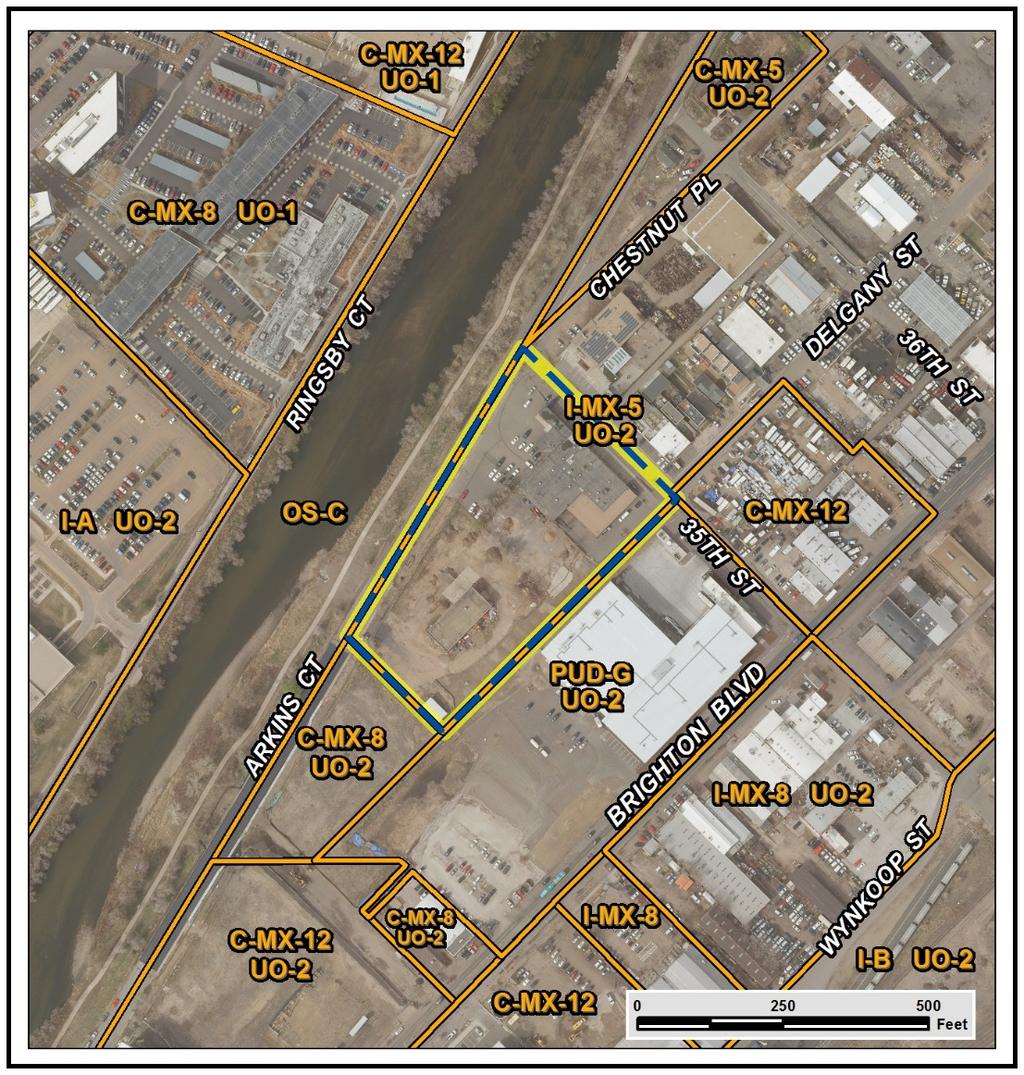
3 Page 3 Existing Context The subject properties are in a rapidly changing area with a mix of industrial, restaurant, and residential uses that abuts the South Platte River corridor. The following table summarizes the existing context proximate to the subject site: Site Existing Zoning I-MX-5, UO-2 Existing Land Uses Warehouse Existing Building Form/Scale th Street has a 21,000 SF, one-story warehouse building built in 1967 and currently used as a Denver Police Department Fleet Services facility Arkins Court is a 5,368 SF parcel used for parking Arkins Court has a 5,468 SF, two-story warehouse building built in 1955 and currently used as city operations storage. Existing Block, Lot, Street Pattern Incomplete grid of streets; Block sizes and shapes are inconsistent, but mostly rectangular. North I-MX-5, UO-2 Warehouse, Restaurant Dog boarding, brewery
4 Page 4 Existing Zoning Existing Land Uses Existing Building Form/Scale Existing Block, Lot, Street Pattern South C-MX-8, UO-2 Vacant n/a East PUD-G 7, UO-2 Warehouse, Restaurant Brewery West OS-C South Platte River n/a 1. Existing Zoning The existing zoning on the subject property is Industrial Mixed Use 5 (I-MX-5). The I-MX zone districts allow a variety of industrial, commercial, civic, and residential uses and are intended to develop in a pedestrian oriented pattern. The UO-2 portion of the zone district is a use overlay allowing billboards subject to limitations. The I-MX-5 zone district allows the General and Industrial building forms with a maximum building height of five stories, or 70 feet. The General building form includes build-to requirements and street level activation requirements, and surface parking is not permitted between the building and the Primary Street. The Industrial building form is limited to industrial uses and does not have buildto requirements and street level activation requirements, and surface parking is permitted between the building and the street.
5 Page 5

6 Page 6 2. Existing Land Use Map The subject properties are surrounded by a mix of industrial, restaurant, and multifamily residential uses east of Arkins Court. West of Arkins Court is the South Platte River corridor, with the multiuse path running parallel to Arkins Court on the east side of the river.


")
7 Page 7 3. Existing Building Form and Scale The existing building form and scale of the subject site and adjacent properties are shown in the images on the following pages. Subject Site Images (source: Google Maps) Subject Property (3400 Arkins Ct.) Subject Property ( th St.)

")

8 Page 8 Subject Property ( th St.) Surrounding Area Images (source: Google Maps) Surrounding Properties Looking North Subject property Surrounding Properties Looking East


9 Page 9 Surrounding Properties Looking West Subject property Surrounding Properties Looking South Summary of City Agency Referral Comments As part of the DZC review process, the rezoning application is referred to potentially affected city agencies and departments for comment. A summary of agency referral responses follows: Public Works Surveyor: Approved with comments - There is a typo in the 4th from last line of the legal description for 3460 Arkins/ th St. Please see attachment. Typo has been fixed. Asset Management: Approved Development Services Project Coordination: Approved Development Services Wastewater: Approved with comments DS Wastewater approves the subject zoning change. The applicant should note that redevelopment of this site may require additional engineering. The extent of the required design and wastewater improvements will be determined once this property begins the redevelopment process.
10 Page 10 Environmental Health: Approved with comments Notes. DDPHE has information showing soil in the area planned for rezoning contains elevated concentrations of polynuclear aromatic hydrocarbons and metals and contains debris. Denver s Guidance for Reuse of Soil on City Projects dated October 5, 2017 specifies that property intended for open space must meet residential standards for all contaminants except arsenic. Arsenic concentrations cannot exceed 11 mg/kg. Accordingly, the rezoned site will require at least six inches of imported soil that meets unrestricted residential criteria. Any existing soil that is disturbed during construction will need to be removed and disposed off site at Denver Arapahoe Disposal Site. General Notes: Most of Colorado is high risk for radon, a naturally occurring radioactive gas. Due to concern for potential radon gas intrusion into buildings, DEH suggests installation of a radon mitigation system in structures planned for human occupation or frequent use. It may be more cost effective to install a radon system during new construction rather than after construction is complete. If renovating or demolishing existing structures, there may be a concern of disturbing regulated materials that contain asbestos or lead-based paint. Materials containing asbestos or lead-based paint should be managed in accordance with applicable federal, state and local regulations. The Denver Air Pollution Control Ordinance (Chapter 4- Denver Revised Municipal Code) specifies that contractors shall take reasonable measures to prevent particulate matter from becoming airborne and to prevent the visible discharge of fugitive particulate emissions beyond the property on which the emissions originate. The measures taken must be effective in the control of fugitive particulate emissions at all times on the site, including periods of inactivity such as evenings, weekends, and holidays. Denver s Noise Ordinance (Chapter 36 Noise Control, Denver Revised Municipal Code) identifies allowable levels of noise. Properties undergoing Re-Zoning may change the acoustic environment, but must maintain compliance with the Noise Ordinance. Compliance with the Noise Ordinance is based on the status of the receptor property (for example, adjacent Residential receptors), and not the status of the noise-generating property. Violations of the Noise Ordinance commonly result from, but are not limited to, the operation or improper placement of HV/AC units, generators, and loading docks. Construction noise is exempted from the Noise Ordinance during the following hours, 7am 9pm (Mon Fri) and 8am 5pm (Sat & Sun). Variances for nighttime work are allowed, but the variance approval process requires 2 to 3 months. For variance requests or questions related to the Noise Ordinance, please contact Paul Riedesel, Denver Environmental Health ( ). Scope & Limitations: DEH performed a limited search for information known to DEH regarding environmental conditions at the subject site. This review was not intended to conform to ASTM standard practice for Phase I site assessments, nor was it designed to identify all potential environmental conditions. In addition, the review was not intended to assess environmental conditions for any potential right-of-way or easement conveyance process. The City and County of Denver provides no representations or warranties regarding the accuracy, reliability, or completeness of the information provided.
11 Page 11 Public Review Process Date CPD informational notice of receipt of the rezoning application to all affected members of City Council and registered neighborhood organizations Property legally posted for a period of 15 days and CPD written notice of the Planning Board public hearing sent to all affected members of City Council and registered neighborhood organizations 1/5/18 2/5/18 2/21/18 Planning Board recommended approval by a vote of 9-0 2/21/18 Land Use, Transportation and Infrastructure Committee of the City Council recommended that the application move to City Council 3/13/18 Property legally posted for a period of 21 days and CPD written notice of the City Council public hearing sent to all affected members of City Council and registered 4/1/18 neighborhood organizations City Council Public Hearing 4/23/18 The RNOs identified on page 1 were notified of this application. As of the time of this writing, no public comments have been received. Criteria for Review / Staff Evaluation The criteria for review of this rezoning application are found in DZC, Sections and , as follows: DZC Section Consistency with Adopted Plans 2. Uniformity of District Regulations and Restrictions 3. Public Health, Safety and General Welfare DZC Section Justifying Circumstances 2. Consistency with Neighborhood Context Description, Zone District Purpose and Intent Statements 1. Consistency with Adopted Plans The following adopted plans apply to this property: Denver Comprehensive Plan 2000 Blueprint Denver (2002) Denver Parks Game Plan (2003) River North Plan (2003) Elyria & Swansea Neighborhoods Plan (2015) 38th and Blake Station Area Plan (2009) and height amendments (2016)

12 Page 12 Denver Comprehensive Plan 2000 The proposal is consistent with many Denver Comprehensive Plan strategies, including: Land Use Vision: Preserve and enhance Denver s livable urban environment through development and maintenance of parks. (p. 55) Urban Design Vision: To the extent possible, parks, open space and affordable recreation will be accessible to all residents in every part of the city. (p. 97) Preservation of Urban Legacies: Denver s highly livable urban environment will be preserved and enhanced through policies that support the ongoing development and maintenance of the parks and parkways system, preserve historic resources, and require quality urban design consistent with Denver s traditional character. (p. 55) Neighborhood Economic Activity Strategy 5-A: Make neighborhoods clean and safe, and provide park, recreational and cultural amenities nearby. (p. 136) The proposed map amendment would support development of a city park in an area with an increasing, unmet demand for parks. The rezoning is consistent with these plan recommendations. Blueprint Denver (2002) According to Blueprint Denver, 3400 Arkins Court has a concept land use of Park and is located in an Area of Change Arkins Court, th St., th St., and th St. have a concept land use of Mixed Use and are located in an Area of Change. Future Land Use Blueprint Denver describes Parks and Open Space as public spaces ranging from historic, traditional parks to natural areas along waterways. Parks and open spaces range from active neighborhood and community parks with recreation fields and centers to larger preserves of natural open areas that provide space for wildlife habitat. (p. 40) Blueprint Denver describes Mixed Use as areas with a wide range of residential and nonresidential uses within walking distance of each other within a neighborhood. (p. 41)
13 Page 13 The proposed map amendment supports the Blueprint Denver future land use designation for both Parks and Mixed Use because it will support development of a park within walking distance of a mix of residential and nonresidential uses. Area of Change The site is in an Area of Change. The goal for Areas of Change is to channel growth where it will be beneficial and can best improve access to jobs, housing and services with fewer and shorter auto trips (p. 127). One Area of Change strategy is to provide adequate parks and open space, especially where density is increased (p. 23). The proposed map amendment is consistent with the Area of Change designation because it will support neighborhooodserving redevelopment of an underutilized site where density is increasing. Street Classifications Blueprint Denver classifies Arkins Court as a Residential Collector. Blueprint Denver states collectors are designed to provide a greater balance between mobility and land access within residential, commercial and industrial areas. (p. 51) Blueprint Denver classifies 35 th Street as an Undesignated Local street. Blueprint Denver states the design features of local streets are influenced less by traffic volumes and are tailored more to providing local access. Mobility on local streets is typically incidental and involves relatively short trips at lower speeds to and from other streets (p. 51). The city park allowed by OS-A can be suitable along such streets, so the proposed rezoning is consistent with Blueprint Denver street classifications. Denver Parks Game Plan (2003) The proposal is consistent with the Denver Parks Game Plan vision for safe, accessible and flexible open spaces located within ½ mile of every home (page 31). The Game Plan describes a number of amenities that could be in the city s open spaces, which include active and passive recreation and community gardens. With a zoning of OS-A, the subject properties will have more flexibility to make improvements that support open space and parks uses and the city will better implement the goals of the Game Plan. Most city parks are zoned OS-A. Elyria & Swansea Plan (2015) The Elyria & Swansea Plan was adopted by City Council in 2015 and includes the subject properties. However, the plan s focus area is the Elyria & Swansea neighborhoods that are north and east of the map amendment request. The plan s concept land use map identifies 3400 Arkins as Future Open Space, which is consistent with the requested map amendment. (p. 45)

14 Page 14 Subject Properties ELYRIA & SWANSEA PLAN LAND USE MAP 38th and Blake Station Area Plan (2009) and height amendments The 38 th and Blake Station Area Plan was adopted by City Council in 2009 and applies to the subject property. This plan provides the most recent, focused guidance for the subject properties. The station area plan s land use map identifies the all of the subject properties as New Open Space and Parks, making the OS-A zone district consistent with this designation. (p. 49) The proposal is also consistent with several 38th and Blake Station Area Plan policies, including policies to better connect neighborhoods to the South Platte River, and to expand parks and open space to serve additional growth in the area. (p 53)

15 Page 15 Subject Properties 38 TH AND BLAKE PLAN FUTURE LAND USE MAP River North Plan (2003) The River North Plan was adopted by City Council in 2003 and applies to the subject properties. The plan provides limited focused guidance for the requested map amendment, but does contain policies supporting development of parks and open space. The station area plan s land use map identifies the subject site as River Corridor Mixed Use, which has a policy supporting replacement of industrial uses with nonindustrial uses that enhance South Platte River frontage (p. 65)
16 Page Uniformity of District Regulations and Restrictions The proposed rezoning to OS-A would result in the uniform application of zone district building form, use, and design regulations. 3. Public Health, Safety and General Welfare The proposed official map amendment furthers the public health, safety, and general welfare of the City primarily through the implementation of the City s adopted plans. The proposed map amendment is closely aligned with adopted neighborhood plans and would support development of a city park in an area with an increasing, unmet demand for parks. 4. Justifying Circumstance The rezoning is justified under DZC Section A.4, The land or its surrounding environs has changed or is changing to such a degree that it is in the public interest to encourage a redevelopment of the area or to recognize the changed character of the area. The RiNo and Brighton Boulevard area is undergoing a transformation that includes a significant density increase. The rezoning is in the public interest to recognize the changed character of the area and the need for a corresponding increase in city parks and open space. 5. Consistency with Neighborhood Context Description, Zone District Purpose and Intent Statements The OS-A zone district is intended to protect and preserve public parks owned, operated or leased by the City and managed by the City s Department of Parks and Recreation for park purposes (DZC 9.3.1, 9.3.2). The requested rezoning is consistent with the neighborhood context description and zone district purpose and intent because the requested zoning will make the property consistent with existing city ownership of, and future plans for, the subject properties. The OS-A zone district is specifically for city parks, and is the most common zone district for city parks including nearby St. Charles Place Park and Globeville Landing Park. Attachments 1. Rezoning application
 865-2914 Email brad.")

 Assessor's Record, (b) Warranty deed or deed of trust, or (c) Title policy or")
17 Zone Map Amendment (Rezoning) - Application Property Owner Name Address City of Denver 201 W. Colfax City, State, Zip Denver, CO Telephone (720) PROPERli:t OWNER(S) REPRESENT'AtlVEH -,...,... l'4l. HECK IF POINT! :con_,: ct FOR APPLIC_ATJ.2.N i;f... Representative Name Brad Buchanan Address 201 W. Colfax City, State, Zip Denver, CO Telephone (720) brad. buchanan@denvergov.org brad. buchanan@denvergov.org *If More Than One Property Owner: AII standard zone map amendment applications shall be initiated by all the owners of at least 51 % of the total area of the zone lots subject to the rezoning application, or their representatives authorized in writing to do so. See page 3. **Property owner shall provide a written letter authorizing the representative to act on his/her behalf. Please attach Proof of Ownership acceptable to the Manager for each property owner signing the application, such as (a) Assessor's Record, (b) Warranty deed or deed of trust, or (c) Title policy or commitment dated no earlier than 60 days prior to application date. If the owner is a corporate entity, proof of authorization for an individual to sign on behalf of the organization is required. This can include board resolutions authorizing the signer, bylaws, a Statement of Authority, or other legal documents as approved by the City Attorney's Office SUBJECT PR PERT ATION Location (address and/or boundary description): 3400 Arkins Ct, 3460 Arkins Ct, th St Assessor's Parcel Numbers: Area in Acres or Square Feet: Current Zone District(s): - Proposed Zone District: , , ,663 SF/3.2 acres I-MX-5/UO-2 c -- OS-A (Open Space Public Parks District) Last updated: February 22, 2017 Return completed form to rezoning@denvergov.org.-- _,, - -r :.:: ; -, -t :-,...,._, < 201 W. Colfax Ave., Dept.' 205 A -' e ver,( r -3- g@denvergov.org 2017I April 12, 2018 Fees waived per DZC

18 COMMUNITY PLANNING & DEVELOPMENT REZONING GUIDE Rezoning Application Page 2 of 3 REVIEW CRITERIA Consistency with Adopted Plans: The proposed official map amendment is consistent with the City s adopted plans, or the proposed rezoning is necessary to provide land for a community need that was not anticipated at the time of adoption of the City s Plan. General Review Criteria: The proposal must comply with all of the general review criteria DZC Sec Additional Review Criteria for Non-Legislative Rezonings: The proposal must comply with both of the additional review criteria DZC Sec Please provide an attachment describing relevant adopted plans and how proposed map amendment is consistent with those plan recommendations; or, describe how the map amendment is necessary to provide for an unanticipated community need. Uniformity of District Regulations and Restrictions: The proposed official map amendment results in regulations and restrictions that are uniform for each kind of building throughout each district having the same classification and bearing the same symbol or designation on the official map, but the regulations in one district may differ from those in other districts. Public Health, Safety and General Welfare: The proposed official map amendment furthers the public health, safety, and general welfare of the City. Justifying Circumstances - One of the following circumstances exists: The existing zoning of the land was the result of an error. The existing zoning of the land was based on a mistake of fact. The existing zoning of the land failed to take into account the constraints on development created by the natural characteristics of the land, including, but not limited to, steep slopes, floodplain, unstable soils, and inadequate drainage. The land or its surroundings has changed or is changing to such a degree that it is in the public interest to encourage a redevelopment of the area to recognize the changed character of the area. It is in the public interest to encourage a departure from the existing zoning through application of supplemental zoning regulations that are consistent with the intent and purpose of, and meet the specific criteria stated in, Article 9, Division 9.4 (Overlay Zone Districts), of this Code. Please provide an attachment describing the justifying circumstance. The proposed official map amendment is consistent with the description of the applicable neighborhood context, and with the stated purpose and intent of the proposed Zone District. REQUIRED ATTACHMENTS Please provide an attachment describing how the above criterion is met. Please ensure the following required attachments are submitted with this application: Legal Description (required to be attached in Microsoft Word document format) Proof of Ownership Document(s) Review Criteria ADDITIONAL ATTACHMENTS Please identify any additional attachments provided with this application: Written Authorization to Represent Property Owner(s) Individual Authorization to Sign on Behalf of a Corporate Entity Please list any additional attachments: Last updated: February 22, 2017 Return completed form to rezoning@denvergov.org 201 W. Colfax Ave., Dept. 205 Denver, CO rezoning@denvergov.org 2017I April 12, 2018 Fees waived per DZC

19 2017I April 12, 2018 Fees waived per DZC
20 3400 Arkins Court and Legal Description Portions of Lots 6 to 27, Block 15, First Addition to Ironton, and the vacated alley adjacent to said lots and portions of the vacated Delgany Street and vacated 34 th Street adjacent to said lots and portions of Lots 1, 2, 3, 30, 31 and 32, Block 14, First Addition to Ironton and the vacated alley adjacent to said lots and portions of vacated Delgany Street and vacated 34 th Street adjacent to said lots and a portion of the SE ¼ of the SE ¼ of Section 22, Township 3 South, Range 68 West of the 6 th P.M., City and County of Denver, State of Colorado, more particularly described as follows: Commencing at the NW corner of Lot 1, Block 13, First Addition to Ironton, thence Westerly along the Northerly line of said Lot extended feet, thence on a deflection angle to the left of , feet to the True Point of Beginning; thence continuing along said above described course feet; thence on a deflection angle to the right of , feet to the Southeasterly right-ofway line of Arkins Court, thence on a deflection angle to the right of along said right-of-way line, feet, thence on a deflection angle to the right of leaving said right-of-way line, feet to the True Point of Beginning, Except that portion as described in Deed recorded June 21, 1994 at Reception No , City and County of Denver, State of Colorado. located at 3400 Arkins Court, Denver, Colorado. 2017I April 12, 2018 Fees waived per DZC
21 3460 Arkins Court and th Street Legal Description Portions of Lots 1 to 10 and 27 to 32, Block 15, FIRST ADDITION TO IRONTON, and the vacated alley adjacent to said lots and a portion of vacated Delgany Street adjacent to said lots, City and County of Denver, State of Colorado, more particularly described as follows: Commencing at the N.W. Corner of Lot 1, Block 13, FIRST ADDITION TO IRONTON; thence northwesterly along the northerly line of said lot extended, feet to the TRUE POINT OF BEGINNING; thence southwesterly on a deflection angle to the left of , feet; thence northwesterly on a deflection angle to the right of , feet; thence southwesterly on a deflection angle to the left of , feet; thence northwesterly on a deflection angle to the right of , feet to the southeasterly right-of-way line of Arkins Court; thence northeasterly on a deflection angle to the right of along said right-of-way line, feet, thence northeasterly on a deflection angle to the right of along said right-of-way line, feet to the northerly lone line of Lot 1, Block 15, FIRST ADDITION TO IRONTON, thence southeasterly along said lot line extended on a deflection angle of to the right, feet to the TRUE POINT OF BEGINNING. The above described parcel contains 47,316 square feet ( acres) more or less. 2017I April 12, 2018 Fees waived per DZC
22 2017I April 12, 2018 Fees waived per DZC
23 2017I April 12, 2018 Fees waived per DZC
24 2017I April 12, 2018 Fees waived per DZC
25 2017I April 12, 2018 Fees waived per DZC
26 Review Criteria Analysis Consistency with Adopted Plans Denver Comprehensive Plan 2000 The proposal is consistent with many Denver Comprehensive Plan strategies, including: Promote the development of sustainable communities and centers of activity where shopping, jobs, recreation and schools are accessible. (p. 41) Preserve and enhance Denver s livable urban environment through development and maintenance of parks (p. 55) To the extent possible, parks, open space and affordable recreation will be accessible to all residents in every part of the city (p. 97) Integrate sufficient open space and recreational amenities, including small urban parks, into large-scale development plans. (p. 102) The city has identified the subject properties for a future park for several years, recognizing the rapidly increasing demand for parkland in the River North community. The rezoning would enable a future park to meet the comprehensive goals stated above. Blueprint Denver (2002) According to Blueprint Denver, 3400 Arkins Ct has a concept land use of Park and 3460 Arkins Ct & th St have a concept land use of Mixed Use. Both properties are located within an Area of Change. The proposal is consistent with several Blueprint Denver policies, including as the intensity of development increases in Areas of Change, so too should access to parks and recreation (p. 132). 38th and Blake Station Area Plan (2009) and Height Amendments The 38th and Blake Station Area Plan provides the most recent, focused plan guidance for the subject properties. This plan identifies the future land use on both properties as New Open Space and Parks. The request is also consistent with the plan policy for the expansion of parks and other open space to serve additional growth in the station area (p. 53). River North Plan (2003) The River North Plan identifies the subject properties as River Corridor Mixed Use, which states new uses should be mixed and take advantage of river frontage (p. 65). The subject properties adjacency to the South Platte River corridor provides an opportunity to take advantage of river frontage with a public park. Elyria Swansea (2015) The Elyria Swansea Plan identifies 3400 Arkins Ct as an Existing Park and 3460 Arkins Ct & th St as Mixed Use. The request is also consistent with the plan policy to increase public access between development and the river (p. 42). 2017I April 12, 2018 Fees waived per DZC
27 Denver Parks Game Plan (2003) The request is consistent with the Denver Parks Game Plan to provide accessible and flexible open spaces located within ½ mile of every home (page 31) in a rapidly developing area. Justifying Circumstances The requested rezoning is justified under DZC Section A.4, The land or its surrounding environs has changed or is changing to such a degree that it is in the public interest to encourage a redevelopment of the area or to recognize the changed character of the area. The River North area is rapidly developing, and with it an increase in demand for parkland. Consistency with Neighborhood Context Description, Zone District Purpose and Intent Statements The OS-A zone district is intended to protect and preserve public parks owned, operated or leased by the City and managed by the City s Department of Parks and Recreation for park purposes (DZC 9.3.1, 9.3.2). The requested rezoning is consistent with the neighborhood context description and zone district purpose and intent because it will make the property consistent with existing city ownership of the subject properties which includes future development for parks and other uses consistent with the OS-A zone district. 2017I April 12, 2018 Fees waived per DZC
Land Use, Transportation, and Infrastructure Committee of the Denver City Council FROM: Scott Robinson, Senior City Planner DATE: March 22, 2018 RE:
 Community Planning and Development Planning Services 201 W. Colfax Ave., Dept. 205 Denver, CO 80202 p: 720.865.2915 f: 720.865.3052 www.denvergov.org/cpd TO: Land Use, Transportation, and Infrastructure
Denver City Council Land Use, Transportation, and Infrastructure Committee FROM: Courtney Levingston, Senior City Planner DATE: July 26, 2018 RE:
 TO: Denver City Council Land Use, Transportation, and Infrastructure Committee FROM: Courtney Levingston, Senior City Planner DATE: RE: Official Zoning Map Amendment Application #2017I-00151 Staff Report
Official Zoning Map Amendment Application #2017I and 4889 South Quebec Street Rezoning from B-4 with waivers, UO-1, UO-2 to C-MX-20
 Community Planning and Development Planning Services 201 W. Colfax Ave., Dept. 205 Denver, CO 80202 p: 720.865.2915 f: 720.865.3052 www.denvergov.org/cpd TO: Denver Planning Board FROM: Jeff Hirt, Senior
Land Use, Transportation, and Infrastructure Committee of Denver City Council FROM: Scott Robinson, Senior City Planner DATE: December 6, 2018 RE:
 Community Planning and Development Planning Services 201 W. Colfax Ave., Dept. 205 Denver, CO 80202 p: 720.865.2915 f: 720.865.3052 www.denvergov.org/cpd TO: Land Use, Transportation, and Infrastructure
Official Zoning Map Amendment Application #2017I Gaylord Street and York Street Rezoning from U-RH-2.5 to U-RX-3 and U-RX-5
 Community Planning and Development Planning Services 201 W. Colfax Ave., Dept. 205 Denver, CO 80202 p: 720.865.2915 f: 720.865.3052 www.denvergov.org/cpd TO: Denver Planning Board FROM: Elizabeth Weigle,
Staff Report and Recommendation Based on the criteria for review in the Denver Zoning Code, Staff recommends approval for Application #2017I
 TO: Denver Planning Board, Joel Noble, Chair FROM: Theresa Lucero, Senior City Planner DATE: RE: Official Zoning Map Amendment Application #2017I-00163 Staff Report and Recommendation Based on the criteria
Land Use, Transportation, & Infrastructure Committee of the Denver City Council FROM: Chandler Van Schaack, Senior City Planner DATE: July 3, 2018 RE:
 Community Planning and Development Planning Services TO: Land Use, Transportation, & Infrastructure Committee of the Denver City Council FROM: Chandler Van Schaack, Senior City Planner DATE: July 3, 2018
Official Zoning Map Amendment Application #2018I-00120
 Community Planning and Development Planning Services 201 W. Colfax Ave., Dept. 205 Denver, CO 80202 p: 720.865.2915 f: 720.865.3052 www.denvergov.org/cpd TO: Denver Planning Board FROM: Scott Robinson,
REZONING GUIDE. Zone Map Amendment (Rezoning) - Application. Rezoning Application Page 1 of 3. Return completed form to
 - Application. Rezoning Application Page 1 of 3. Return completed form to") Zone Map Amendment (Rezoning) - Application COMMUNITY PLANNING & DEVELOPMENT REZONING GUIDE Rezoning Application Page 1 of 3 PROPERTY OWNER INFORMATION* CHECK IF POINT OF CONTACT FOR APPLICATION Property
Zone Map Amendment (Rezoning) - Application COMMUNITY PLANNING & DEVELOPMENT REZONING GUIDE Rezoning Application Page 1 of 3 PROPERTY OWNER INFORMATION* CHECK IF POINT OF CONTACT FOR APPLICATION Property
REZONING GUIDE. Zone Map Amendment (Rezoning) - Application. Rezoning Application Page 1 of 3. Return completed form to
 - Application. Rezoning Application Page 1 of 3. Return completed form to") COMMUNITY PLANNING & DEVELOPMENT REZONING GUIDE Rezoning Application Page 1 of 3 Zone Map Amendment (Rezoning) - Application PROPERTY OWNER INFORMATION* PROPERTY OWNER(S) REPRESENTATIVE** CHECK IF POINT
COMMUNITY PLANNING & DEVELOPMENT REZONING GUIDE Rezoning Application Page 1 of 3 Zone Map Amendment (Rezoning) - Application PROPERTY OWNER INFORMATION* PROPERTY OWNER(S) REPRESENTATIVE** CHECK IF POINT
Request for Rezoning. Current Zoning: Proposed Zoning:
 TO: Denver City Council, Neighborhoods and Planning Committee FROM: Theresa Lucero, Senior City Planner DATE: March 31, 2016 RE: Zoning Map Amendment #2015I-00150 Rezoning from M-RX-5 to I-MX-3 Community
REZONING GUIDE. Zone Map Amendment (Rezoning) - Application. Rezoning Application Page 1 of 3. Return completed form to
 - Application. Rezoning Application Page 1 of 3. Return completed form to") Zone Map Amendment (Rezoning) - Application COMMUNITY PLANNING & DEVELOPMENT REZONING GUIDE Rezoning Application Page 1 of 3 PROPERTY OWNER INFORMATION* CHECK IF POINT OF CONTACT FOR APPLICATION Property
Zone Map Amendment (Rezoning) - Application COMMUNITY PLANNING & DEVELOPMENT REZONING GUIDE Rezoning Application Page 1 of 3 PROPERTY OWNER INFORMATION* CHECK IF POINT OF CONTACT FOR APPLICATION Property
Official Zoning Map Amendment Application #2017I-00094
 Community Planning and Development Planning Services 201 W. Colfax Ave., Dept. 205 Denver, CO 80202 p: 720.865.2915 f: 720.865.3052 www.denvergov.org/cpd TO: Denver Planning Board FROM: Scott Robinson,
REZONING GUIDE. Zone Map Amendment (Rezoning) - Application. Rezoning Application Page 1 of 3. Return completed form to
 - Application. Rezoning Application Page 1 of 3. Return completed form to") COMMUNITY PLANNING & DEVELOPMENT REZONING GUIDE Rezoning Application Page 1 of 3 Zone Map Amendment (Rezoning) - Application PROPERTY OWNER INFORMATION* PROPERTY OWNER(S) REPRESENTATIVE** CHECK IF POINT
COMMUNITY PLANNING & DEVELOPMENT REZONING GUIDE Rezoning Application Page 1 of 3 Zone Map Amendment (Rezoning) - Application PROPERTY OWNER INFORMATION* PROPERTY OWNER(S) REPRESENTATIVE** CHECK IF POINT
Official Zoning Map Amendment Application #2018I-00067
 Community Planning and Development Planning Services 201 W. Colfax Ave., Dept. 205 Denver, CO 80202 p: 720.865.2915 f: 720.865.3052 www.denvergov.org/cpd TO: Denver Planning Board FROM: Courtney Levingston,
Representative Name. Address. City, State, Zip. Telephone.
 COMMUNITY PLANNING & DEVELOPMENT ~~DENVER... THE MILE HIGH CITY REZONING GUIDE Zone Map Amendment (Rezoning)- Application Rezoning Application Page 1 of 3 Property Owner Name Philip M. Falco Address 730
Telephone AC / 21,960 SF G-MU-3 G-MX-3
 Zone Map Amendment (Rezoning) - Application PROPERTY OWNER INFORMATION* CHECK IF POINT OF CONTACT FOR APPLICATION Property Owner Name Siddhartha Rathod Address City, State, Zip Telephone Email COMMUNITY
Official Zoning Map Amendment Application #2017I-00090
 Community Planning and Development Planning Services 201 W. Colfax Ave., Dept. 205 Denver, CO 80202 p: 720.865.2915 f: 720.865.3052 www.denvergov.org/cpd TO: Land Use, Transportation, & Infrastructure
Block bounded by Newton St., 17 th Ave., Lowell Blvd., and 16 th Ave.; plus Meade Street (evens only)
") Community Planning and Development Planning Services 201 W. Colfax Ave., Dept. 205 Denver, CO 80202 p: 720.865.2915 f: 720.865.3052 www.denvergov.org/cpd TO: Denver Planning Board FROM: Sara White, AICP,
Community Planning and Development Planning Services 201 W. Colfax Ave., Dept. 205 Denver, CO 80202 p: 720.865.2915 f: 720.865.3052 www.denvergov.org/cpd TO: Denver Planning Board FROM: Sara White, AICP,
Based on the criteria for review in the Denver Zoning Code, Staff recommends approval for Application #2018I
 Community Planning and Development Planning Services 201 W. Colfax Ave., Dept. 205 Denver, CO 80202 p: 720.865.2915 f: 720.865.3052 www.denvergov.org/cpd TO: Denver Planning Board FROM: Chandler Van Schaack,
To: S-MX-8 AIO, S-MX-8A AIO, S-MX-12 AIO, C-MX-8 AIO, C-MX-12 AIO, and S-CC-5 AIO
 Community Planning and Development Planning Services 201 W. Colfax Ave., Dept. 205 Denver, CO 80202 p: 720.865.2915 f: 720.865.3052 www.denvergov.org/cpd TO: Denver City Council FROM: Curt Upton, Senior
E-SU-A. Zone Map Amendment (Rezoning) -Application E-SU-B. Rf tum cornpleted form to rezoning(i:})denvergov.org. *If More Than One Property Owner;
 -Application E-SU-B. Rf tum cornpleted form to rezoning(i:})denvergov.org. *If More Than One Property Owner;") Zone Map Amendment (Rezoning) -Application Property Owner Name Philip M. Falco Representative Name Address 730 17th Street, Suite 900 Address City, State, Zip Denver, CO 80202 City, State, Zip Telephone
Zone Map Amendment (Rezoning) -Application Property Owner Name Philip M. Falco Representative Name Address 730 17th Street, Suite 900 Address City, State, Zip Denver, CO 80202 City, State, Zip Telephone
Staff Report and Recommendation
 Community Planning and Development Planning Services 201 W. Colfax Ave., Dept. 205 Denver, CO 80202 p: 720.865.2915 f: 720.865.3052 www.denvergov.org/cpd TO: Denver Planning Board FROM: Andrew Webb, Senior
Official Zoning Map Amendment Application #2018I-00095
 Community Planning and Development Planning Services 201 W. Colfax Ave., Dept. 205 Denver, CO 80202 p: 720.865.2915 f: 720.865.3052 www.denvergov.org/cpd TO: Denver Planning Board FROM: Ella Stueve, Senior
Official Zoning Map Amendment Application #2015I Marion St. Rezoning from U-SU-A1 to U-MX-2x
 Community Planning and Development Planning Services 201 W. Colfax Ave., Dept. 205 Denver, CO 80202 p: 720.865.2915 f: 720.865.3052 www.denvergov.org/cpd TO: Denver City Council FROM: Courtland Hyser,
Staff Report and Recommendation Based on the criteria for review in the Denver Zoning Code, Staff recommends approval for application #2017I
 TO: Denver City Council, Land Use, Transportation and Infrastructure Committee FROM: Theresa Lucero, Senior City Planner DATE: RE: Official Zoning Map Amendment Application #2017I-00153 Staff Report and
REZONING GUIDE. Zone Map Amendment (Rezoning) - Application. Applicant: Albus Brooks, Councilman District 9
 - Application. Applicant: Albus Brooks, Councilman District 9") Zone Map Amendment (Rezoning) - Application COMMUNITY PLANNING & DEVELOPMENT REZONING GUIDE Rezoning Application Page 1 of 3 PROPERTY OWNER INFORMATION* CHECK IF POINT OF CONTACT FOR APPLICATION Property
Zone Map Amendment (Rezoning) - Application COMMUNITY PLANNING & DEVELOPMENT REZONING GUIDE Rezoning Application Page 1 of 3 PROPERTY OWNER INFORMATION* CHECK IF POINT OF CONTACT FOR APPLICATION Property
REZONING GUIDE. Zone Map Amendment (Rezoning) - Application. Rezoning Application Page 1 of 3. Return completed form to
 - Application. Rezoning Application Page 1 of 3. Return completed form to") Zone Map Amendment (Rezoning) - Application COMMUNITY PLANNING & DEVELOPMENT REZONING GUIDE Rezoning Application Page 1 of 3 PROPERTY OWNER INFORMATION* CHECK IF POINT OF CONTACT FOR APPLICATION Property
Zone Map Amendment (Rezoning) - Application COMMUNITY PLANNING & DEVELOPMENT REZONING GUIDE Rezoning Application Page 1 of 3 PROPERTY OWNER INFORMATION* CHECK IF POINT OF CONTACT FOR APPLICATION Property
Zone Map Amendment (Rezoning) for PUD - Application York St. U-MX-3, B-2 with Waivers. General PUD. Yes. See Attachment C U-MX-3, I-MX-3
 for PUD - Application York St. U-MX-3, B-2 with Waivers. General PUD. Yes. See Attachment C U-MX-3, I-MX-3") COMMUNITY PLANNING & DEVELOPMENT REZONING GUIDE Rezoning Application for PUD Page 1 of 3 Zone Map Amendment (Rezoning) for PUD - Application PROPERTY OWNER INFORMATION* CHECK IF POINT OF CONTACT FOR APPLICATION
COMMUNITY PLANNING & DEVELOPMENT REZONING GUIDE Rezoning Application for PUD Page 1 of 3 Zone Map Amendment (Rezoning) for PUD - Application PROPERTY OWNER INFORMATION* CHECK IF POINT OF CONTACT FOR APPLICATION
Official Zoning Map Amendment Application #2015I N. King Street and 3441 W. 39 th Ave Rezoning from PUD 406 to U-SU-B1
 Community Planning and Development Planning Services 201 W. Colfax Ave., Dept. 205 Denver, CO 80202 p: 720.865.2915 f: 720.865.3052 www.denvergov.org/cpd TO: Neighborhoods and Planning Committee FROM:
DZC and DRMC Amendments to Implement 38th and Blake Station Area Height Amendments
 DZC and DRMC Amendments to Implement 38th and Blake Station Area Height Amendments DZC Text Amendment #2 to establish River North Design Overlay (DO-7) / 38 th and Blake Incentive Overlay (IO-1) (CB18-0016)
City Council Land Use, Transportation, and Infrastructure Committee FROM: Jeff Hirt, Senior City Planner DATE: March 9, 2018 RE:
 TO: City Council Land Use, Transportation, and Infrastructure Committee FROM: Jeff Hirt, Senior City Planner DATE: March 9, 2018 RE: Official Zoning Map Amendment #2015I-00168 Community Planning and Development
REZONING GUIDE. Zone Map Amendment (Rezoning) - Application. Rezoning Application Page 1 of 3. Return completed form to
 - Application. Rezoning Application Page 1 of 3. Return completed form to") Zone Map Amendment (Rezoning) - Application COMMUNITY PLANNING & DEVELOPMENT REZONING GUIDE Rezoning Application Page 1 of 3 PROPERTY OWNER INFORMATION* CHECK IF POINT OF CONTACT FOR APPLICATION Property
Zone Map Amendment (Rezoning) - Application COMMUNITY PLANNING & DEVELOPMENT REZONING GUIDE Rezoning Application Page 1 of 3 PROPERTY OWNER INFORMATION* CHECK IF POINT OF CONTACT FOR APPLICATION Property
PLANNING COMMISSION STAFF REPORT
 PLANNING COMMISSION STAFF REPORT West Capitol Hill Zoning Map Amendment Petition No. PLNPCM2011-00665 Located approximately at 548 W 300 North Street, 543 W 400 North Street, and 375 N 500 West Street
PLANNING COMMISSION STAFF REPORT
 PLANNING COMMISSION STAFF REPORT REZONING CASE: RZ-16-001 REPORT DATE: March 8, 2016 CASE NAME: Trailbreak Partners Rezoning PLANNING COMMISSION DATE: March 16, 2016 ADDRESSES OF REZONING PROPOSAL: 5501
Public Review of the Slot Home Text Amendment
 Public Review of the Slot Home Text Amendment The proposed amendments to the Denver Zoning Code have been informed by the Slot Home Strategy Report. This document has been developed out of a robust process
PC Staff Report 11/18/2013 Z Item No. 1-1
 Z-13-00401 Item No. 1-1 PLANNING COMMISSION REPORT Regular Agenda - Public Hearing Item PC Staff Report 11/18/2013 ITEM NO. 1: Z-13-00401 IG (General Industrial) District TO CS (Strip Commercial) District;
SUBDIVISION, PLANNED UNIT DEVELOPMENT, ZONING AMENDMENT, & SIDEWALK WAIVER STAFF REPORT Date: July 19, 2018
 SUBDIVISION, PLANNED UNIT DEVELOPMENT, ZONING AMENDMENT, & SIDEWALK WAIVER STAFF REPORT Date: July 19, 2018 NAME SUBDIVISION NAME LOCATION West Mobile Properties, LLC U.S. Machine Subdivision 556, 566,
PERMITTED USES: Within the MX-1 Mixed Use Neighborhood District the following uses are permitted:
 6.25 MX-1 - MIXED USE NEIGHBORHOOD 6.25.1 INTENT: The purpose of the MX-1 Mixed Use Neighborhood District is to accommodate the development of a wide-range of residential and compatible non-residential
Article 3. SUBURBAN (S-) NEIGHBORHOOD CONTEXT
 NEIGHBORHOOD CONTEXT") Article 3. SUBURBAN (S-) NEIGHBORHOOD CONTEXT this page left intentionally blank Contents ARTICLE 3. SUBURBAN (S-) NEIGHBORHOOD CONTEXT DIVISION 3.1 NEIGHBORHOOD CONTEXT DESCRIPTION...3.1-1 Section 3.1.1
Article 3. SUBURBAN (S-) NEIGHBORHOOD CONTEXT this page left intentionally blank Contents ARTICLE 3. SUBURBAN (S-) NEIGHBORHOOD CONTEXT DIVISION 3.1 NEIGHBORHOOD CONTEXT DESCRIPTION...3.1-1 Section 3.1.1
REZONING GUIDE. Zone Map Amendment (Rezoning) - Application. Rezoning Application Page 1 of 3. Return completed form to
 - Application. Rezoning Application Page 1 of 3. Return completed form to") Zone Map Amendment (Rezoning) - Application COMMUNITY PLANNING & DEVELOPMENT REZONING GUIDE Rezoning Application Page 1 of 3 PROPERTY OWNER INFORMATION* CHECK IF POINT OF CONTACT FOR APPLICATION Property
Zone Map Amendment (Rezoning) - Application COMMUNITY PLANNING & DEVELOPMENT REZONING GUIDE Rezoning Application Page 1 of 3 PROPERTY OWNER INFORMATION* CHECK IF POINT OF CONTACT FOR APPLICATION Property
Town of Bristol Rhode Island
 Town of Bristol Rhode Island Subdivision & Development Review Regulations Adopted by the Planning Board September 27, 1995 (March 2017) Formatted: Highlight Formatted: Font: 12 pt Table of Contents TABLE
Salem HNA and EOA Advisory Committee Meeting #6
 Salem HNA and EOA Advisory Committee Meeting #6 Residential Land Policies Employment Land Policies Policy Discussions with the Committee Outcome of today s meeting Direction from this Committee on proposed
8/17/16 PC Meeting 1
 1 GENERAL INFORMATION OWNER/APPLICANT: Thomas Corff & Terry Moberly (1943 13 th St.) 19328 Towercrest Dr. Oregon City, OR 97045 Michael & Jill Parker (1983 13 th St.) 1708 Oak St. Lake Oswego, OR 97034
Bylaw No , being "Official Community Plan Bylaw, 2016" Schedule "A" DRAFT
 Bylaw No. 2600-2016, being "Official Community Plan Bylaw, 2016" Schedule "A" Urban Structure + Growth Plan Urban Structure Land use and growth management are among the most powerful policy tools at the
DIVISION 1 PURPOSE OF DISTRICTS
 ARTICLE 2 ZONING DISTRICTS AND MAP DIVISION 1 PURPOSE OF DISTRICTS Section 2.101 Zoning Districts. For the purpose of this Ordinance, the City of Richmond is hereby divided into districts as follows: DISTRICT
CHAPTER XVIII SITE PLAN REVIEW
 CHAPTER XVIII SITE PLAN REVIEW Section 18.1 Section 18.2 Description and Purpose. The purpose of this chapter is to provide standards and procedures under which applicants would submit, and the Township
this page left intentionally blank DENVER ZONING CODE
 Article 1. GENERAL PROVISIONS this page left intentionally blank Contents ARTICLE 1. GENERAL PROVISIONS DIVISION 1.1 GENERAL...1.1-1 Section 1.1.1 Purpose...1.1-1 Section 1.1.2 Intent...1.1-1 Section 1.1.3
PLANNED UNIT DEVELOPMENT (PUD)
") SECTION 38.01. ARTICLE 38 PLANNED UNIT DEVELOPMENT (PUD) Purpose The purpose of this Article is to implement the provisions of the Michigan Zoning Enabling Act, Public Act 110 of 2006, as amended, authorizing
SECTION 38.01. ARTICLE 38 PLANNED UNIT DEVELOPMENT (PUD) Purpose The purpose of this Article is to implement the provisions of the Michigan Zoning Enabling Act, Public Act 110 of 2006, as amended, authorizing
PLANNING AND ZONING REVIEWS AT THE COUNTY LEVEL
 PLANNING AND ZONING REVIEWS AT THE COUNTY LEVEL Introductions Why do counties review planning and zoning matters? To bring pertinent inter-community and county-wide planning, zoning, site plan and subdivision
COMMUNITY DEVELOPMENT. Staff Report. Site Plan Review. SP June 19, 2018
 COMMUNITY DEVELOPMENT 333 Broadalbin Street SW, PO Box 490, Albany, Oregon 97321-0144 BUILDING 541-917-7553 PLANNING 541-917-7550 Staff Report Site Plan Review SP-18-18 June 19, 2018 Summary On May 1,
Article Optional Method Requirements
 Article 59-6. Optional Method Requirements [DIV. 6.1. MPDU DEVELOPMENT IN RURAL RESIDENTIAL AND RESIDENTIAL ZONES Sec. 6.1.1. General Requirements... 6 2 Sec. 6.1.2. General Site and Building Type Mix...
ARTICLE OPTIONAL METHOD REGULATIONS
 ARTICLE 59-6. OPTIONAL METHOD REGULATIONS DIV. 6.1. MPDU DEVELOPMENT IN RURAL RESIDENTIAL AND RESIDENTIAL ZONES SEC. 6.1.1. GENERAL REQUIREMENTS... 6 2 SEC. 6.1.2. GENERAL SITE AND BUILDING T PE MIX...
TO: City Council FROM: Jeff Hirt, Senior City Planner DATE: April 19, 2018 RE: Official Zoning Map Amendment #2015I-00168
 Community Planning and Development Planning Services 201 W. Colfax Ave., Dept. 205 Denver, CO 80202 p: 720.865.2915 f: 720.865.3052 www.denvergov.org/cpd TO: City Council FROM: Jeff Hirt, Senior City Planner
Chapter 6 Summary Control of Land Use: Control of Land Use
 When someone owns a parcel of real estate, he or she also has a set of legal rights that are attached to the ownership of that parcel. These rights, which have value and can be sold, are known as the bundle
Larimer County Planning Dept. Procedural Guide for 1041 PERMITS
 - Larimer County Planning Dept. Procedural Guide for 1041 PERMITS PLEASE NOTE: A PRE-APPLICATION CONFERENCE IS REQUIRED PRIOR TO SUBMITTING THIS APPLICATION. PURPOSE: State Statutes allow local governments
MIDWAY CITY Municipal Code
 MIDWAY CITY Municipal Code TITLE 9 ANNEXATION CHAPTER 9.01 PURPOSE CHAPTER 9.02 GENERAL REQUIREMENTS CHAPTER 9.03 PROPERTY OWNER INITIATION OF ANNEXATION CHAPTER 9.04 PROCEDURES FOR CONSIDERATION OF PETITION
Draft Model Access Management Overlay Ordinance
 Draft Model Access Management Overlay Ordinance This model was developed using the City of Hutchinson and the Trunk Highway 7 corridor. The basic provisions of this model may be adopted by any jurisdiction
PLANNED UNIT DEVELOPMENTS (Ordinance No.: 3036, 12/3/07; Repealed & Replaced by Ordinance No.: 4166, 10/15/12)
") 159.62 PLANNED UNIT DEVELOPMENTS (Ordinance No.: 3036, 12/3/07; Repealed & Replaced by Ordinance No.: 4166, 10/15/12) A. PURPOSE 1. General. The Planned Unit Development (PUD) approach provides the flexibility
159.62 PLANNED UNIT DEVELOPMENTS (Ordinance No.: 3036, 12/3/07; Repealed & Replaced by Ordinance No.: 4166, 10/15/12) A. PURPOSE 1. General. The Planned Unit Development (PUD) approach provides the flexibility
UDO Advisory Committee Meeting #3 August 18, 2011
 UDO Advisory Committee Meeting #3 August 18, 2011 Today s s Agenda Welcome Recap of Meeting #2 Overview of Strategy Statement Overview of Zoning Districts What changes and what stays the same? Break Putting
COUNTY OF ALBEMARLE PLANNING STAFF REPORT SUMMARY
 COUNTY OF ALBEMARLE PLANNING STAFF REPORT SUMMARY Project Name: ZMA 2010-00015, Cedar Hill Planning Commission Worksession: February 15, 2011 Public Hearing: Not scheduled Staff: Judith C. Wiegand, AICP
REZONING GUIDE. Zone Map Amendment (Rezoning) - Application. Rezoning Application Page 1 of 3. Return completed form to
 - Application. Rezoning Application Page 1 of 3. Return completed form to") COMMUNITY PLANNING & DEVELOPMENT REZONING GUIDE Rezoning Application Page 1 of 3 Zone Map Amendment (Rezoning) - Application PROPERTY OWNER INFORMATION* PROPERTY OWNER(S) REPRESENTATIVE** CHECK IF POINT
COMMUNITY PLANNING & DEVELOPMENT REZONING GUIDE Rezoning Application Page 1 of 3 Zone Map Amendment (Rezoning) - Application PROPERTY OWNER INFORMATION* PROPERTY OWNER(S) REPRESENTATIVE** CHECK IF POINT
Comprehensive Plan /24/01
 IV The is a central component of the Comprehensive Plan. It is an extension of the general goals and policies of the community, as well as a reflection of previous development decisions and the physical
CITY OF HIAWATHA, IOWA TOWN VILLAGE CENTER URBAN REVITALIZATION PLAN. for the TOWN VILLAGE CENTER URBAN REVITALIZATION AREA
 CITY OF HIAWATHA, IOWA TOWN VILLAGE CENTER URBAN REVITALIZATION PLAN for the TOWN VILLAGE CENTER URBAN REVITALIZATION AREA 2018 1 INTRODUCTION The Urban Revitalization Act, Chapter 404 of the Code of Iowa,
PLANNING COMMISSION REPORT Regular Agenda - Public Hearing Item
 Z-15-00469 Item No. 6A- 1 PLANNING COMMISSION REPORT Regular Agenda - Public Hearing Item PC Staff Report 11/16/15 ITEM NO. 6A GPI, RM12, & RS40 TO RM12; 14.756 ACRES; 5200 & 5300 CLINTON PKWY (SLD) Z-15-00469:
PLANNING AND ZONING DEPARTMENT
 Town of Minturn Development Review Process: Guide To Planned Unit Developments (Concept Plan) This guide describes the Planned Unit Development Process. This guide should be utilized in conjunction with
ARTICLE VII. NONCONFORMITIES. Section 700. Purpose.
 ARTICLE VII. NONCONFORMITIES. Section 700. Purpose. The purpose of this chapter is to regulate and limit the development and continued existence of legal uses, structures, lots, and signs established either
Article 6: Planned Unit Developments
 LUDC 2013 GARFIELD COUNTY, COLORADO Article 6: Planned Unit Developments ARTICLE 6 PLANNED UNIT DEVELOPMENTS TABLE OF CONTENTS DIVISION 1. GENERAL.... 1 6-101. GENERAL PROVISIONS.... 1 A. Purpose....
Description of Zoning Resolution Amendment: (attach additional sheets if necessary)
") CARBON COUNTY www.carbonwy.com Department of Planning and Development 215 West Buffalo, Suite 336 Application Fee $200.00 (plus public notice cost) Rawlins, WY 82301 Fee Paid $ Date Tel (307) 328-2651
CARBON COUNTY www.carbonwy.com Department of Planning and Development 215 West Buffalo, Suite 336 Application Fee $200.00 (plus public notice cost) Rawlins, WY 82301 Fee Paid $ Date Tel (307) 328-2651
PLANNING COMMISSION REPORT Regular Agenda -Public Hearing Item
 PDP-13-00518 Item No. 3B- 1 PLANNING COMMISSION REPORT Regular Agenda -Public Hearing Item PC Staff Report 2/24/14 ITEM NO. 3B PRELIMINARY DEVELOPMENT PLAN FOR HERE @ KANSAS; 1101 INDIANA ST (SLD) PDP-13-00518:
EXCERPTS FROM HALIFAX REGIONAL MUNICIPALITY CHARTER
 EXCERPTS FROM HALIFAX REGIONAL MUNICIPALITY CHARTER Municipal planning strategy 227 The Council may adopt a municipal planning strategy for all, or part, of the Municipality and there may be separate strategies
ARTICLE 15 - PLANNED UNIT DEVELOPMENT
 Section 15.1 - Intent. ARTICLE 15 - PLANNED UNIT DEVELOPMENT A PUD, or Planned Unit Development, is not a District per se, but rather a set of standards that may be applied to a development type. The Planned
Guide to Combined Preliminary and Final Plats
 Guide to Combined Preliminary and Final Plats Introduction The Douglas County is committed to providing open, transparent application processes to the public. This Guide is provided to assist anyone interested
Planning Department Oconee County, Georgia
 Planning Department Oconee County, Georgia STAFF REPORT REZONE CASE #: 6985 DATE: October 31, 2016 STAFF REPORT BY: Andrew C. Stern, Planner APPLICANT NAME: Williams & Associates, Land Planners PC PROPERTY
Glades County Staff Report and Recommendation Unified Staff Report for Small Scale Plan Amendment and Rezoning
 Glades County Staff Report and Recommendation Unified Staff Report for Small Scale Plan Amendment and Rezoning CASE NUMBERS: COMP17-02 and RZ17-02 DATE of STAFF REPORT: May 1, 2017 CASE TYPE: Application
Marcel Williams, MPC Project Planner
 TO: FROM: The Planning Commission MPC Staff DATE: SUBJECT: Petition to Rezone Property Heath Shelton, Owner Jay Maupin, Agent 2026 Habersham Street Aldermanic District: 2, Bill Durrence County Commission
Krisana Park S Edison Way. Conservation Overlay (Proposed) Preapp 03/04/15
 Preapp 03/04/15") Krisana Park S Edison Way Conservation Overlay (Proposed) Preapp 03/04/15 Request Private property - Both sides of S. Edison Way: 4.25 acres 24 Single Unit Dwellings Existing Context Zoning Existing Zoning:
Krisana Park S Edison Way Conservation Overlay (Proposed) Preapp 03/04/15 Request Private property - Both sides of S. Edison Way: 4.25 acres 24 Single Unit Dwellings Existing Context Zoning Existing Zoning:
DOUGLAS COUNTY SUBDIVISION RESOLUTION Article 4 Preliminary Plan 10/13/2015
 ARTICLE 4 PRELIMINARY PLAN 401 Intent An in-depth analysis of the proposed subdivision, including a review of the design considering the ability to obtain water and sanitation, identified geologic hazards,
CHAPTER 10 Planned Unit Development Zoning Districts
 CHAPTER 10 Planned Unit Development Zoning Districts Section 10.1 Intent and Purpose The Planned Unit Development (PUD) districts are intended to offer design flexibility for projects that further the
HOUSING ELEMENT GOALS, OBJECTIVES, AND POLICIES
 HOUSING ELEMENT GOALS, OBJECTIVES, AND POLICIES GOAL 1: To promote the preservation and development of high-quality, balanced, and diverse housing options for persons of all income levels throughout the
ARTICLE VI. SUBDIVISION STANDARDS, PUBLIC
 ARTICLE VI. SUBDIVISION STANDARDS, PUBLIC IMPROVEMENTS, AND DESIGN REQUIREMENTS ARTICLE VI. SUBDIVISION STANDARDS, PUBLIC IMPROVEMENTS, AND DESIGN REQUIREMENTS DIVISION 1. GENERAL PROVISIONS Sec. 21-6100.
Metropolitan Planning Commission. DATE: April 5, 2016
 TO: FROM: Metropolitan Planning Commission MPC Staff DATE: April 5, 2016 SUBJECT: Petition of Nine Line Inc. Robert McCorkle, Agent PIN: 2-1034-01-002 380.5 Acres Aldermanic District: 5 (Shabazz) County
REZONING APPLICATION INSTRUCTIONS
 REZONING APPLICATION INSTRUCTIONS All required information, as stated on the Rezoning Application Checklist, must be included to qualify as a complete application. Upon receipt, staff will review the application
CONCEPT PLAN SUBMISSION REQUIREMENTS:
 STAFF STRONGLY RECOMMENDS A PRE-DEVELOPMENT MEETING BEFORE THE SUBMITTAL OF ANY APPLICATION FOR ZONING, REZONING, CONDITIONAL USE PERMIT (CUP), OR FOR A TEXT AMENDMENT TO A PROVISION(S) OF THE ZONING ORDINANCE.
ARTICLE 3: Zone Districts
 ARTICLE 3: Zone Districts... 3-1 17.3.1: General...3-1 17.3.1.1: Purpose and Intent... 3-1 17.3.2: Districts and Maps...3-1 17.3.2.1: Applicability... 3-1 17.3.2.2: Creation of Districts... 3-1 17.3.2.3:
AMENDED ZONING BY-LAW ARTICLE SENIOR LIVING COMMUNITY
 AMENDED ZONING BY-LAW ARTICLE 13.5 - SENIOR LIVING COMMUNITY ARTICLE : To see if the Town will vote to amend the Zoning Bylaw as follows: 2. By deleting existing Section 13.5, Senior Living Community,
SECTION I - INTRODUCTION
 - INTRODUCTION 1 2 - INTRODUCTIONION THE MASTER PLAN State law requires every community to have a Master Plan establishing an orderly guide to the use of lands in the community to protect public health
ARTICLE 5 MINOR SUBDIVISION/LAND DEVELOPMENT
 ARTICLE 5 MINOR SUBDIVISION/LAND DEVELOPMENT SECTION 501 ONLY FINAL PLAN REQUIRED The classification of a proposed subdivision as a "Minor Subdivision" shall only require the submission, review and approval
TASK 2 INITIAL REVIEW AND ANALYSIS U.S. 301/GALL BOULEVARD CORRIDOR FORM-BASED CODE
 TASK 2 INITIAL REVIEW AND ANALYSIS U.S. 301/GALL BOULEVARD CORRIDOR FORM-BASED CODE INTRODUCTION Using the framework established by the U.S. 301/Gall Boulevard Corridor Regulating Plan (Regulating Plan),
PIN , Part 1, Plan SR-713 in Lot 2, Concession 5, Township of McKim (1096 Dublin Street, Sudbury)
") STAFF REPORT Applicant: Dalron Construction Limited Location: PIN 02124-0103, Part 1, Plan SR-713 in Lot 2, Concession 5, Township of McKim (1096 Dublin Street, Sudbury) Official Plan and Zoning By-law:
STAFF REPORT Applicant: Dalron Construction Limited Location: PIN 02124-0103, Part 1, Plan SR-713 in Lot 2, Concession 5, Township of McKim (1096 Dublin Street, Sudbury) Official Plan and Zoning By-law:
2017I September 7, 2018 fees waived per
 Review Criteria for 3610 and 3612 North Clay Street from PUD #504 to U-TU-B. 1. Consistency with Adopted Plans: The following adopted plans apply to this property: Denver Comprehensive Plan 2000 Blueprint
PLANNING COMMISSION STAFF REPORT
 PLANNING COMMISSION STAFF REPORT REZONING CASE: RZ-15-002 REPORT DATE: January 26, 2016 CASE NAME: Thursday Lunch Club Rezoning PLANNING COMMISSION DATE: February 17, 2016 ADDRESS OF REZONING PROPOSAL:
CITY OF FORT COLLINS NATURAL AREAS AND CONSERVED LANDS EASEMENT POLICY
 CITY OF FORT COLLINS NATURAL AREAS AND CONSERVED LANDS EASEMENT POLICY Adopted January 3, 2012 PURPOSE: The purpose of the policy statement is to clarify the policies and procedures of the City of Fort
Appendix A: Guide to Zoning Categories Prince George's County, Maryland
 Appendix A: Guide to Zoning Categories Prince George's County, Maryland RESIDENTIAL ZONES 1 Updated November 2010 R-O-S: Reserved Open Space - Provides for permanent maintenance of certain areas of land
PLANNED UNIT DEVELOPMENT (PUD) AREA PLAN/REZONING REVIEW PROCEDURE
 AREA PLAN/REZONING REVIEW PROCEDURE") PLANNED UNIT DEVELOPMENT (PUD) AREA PLAN/REZONING REVIEW PROCEDURE Professional inquiries will be made to our Township Planning Consultant, Township Engineer, and Township Attorney to get their opinions
PLANNED UNIT DEVELOPMENT (PUD) AREA PLAN/REZONING REVIEW PROCEDURE Professional inquiries will be made to our Township Planning Consultant, Township Engineer, and Township Attorney to get their opinions
MINOR BOUNDARY LINE ADJUSTMENT PROCESS GUIDE
 MINOR BOUNDARY LINE ADJUSTMENT PROCESS GUIDE Clear Creek County Planning Department P.O. Box 2000 Georgetown, Colorado 80444 (303) 679-2436 phone (303) 569-1103 fax 1 PURPOSE To establish criteria and
SUBDIVISION DESIGN PRINCIPLES AND STANDARDS
 SECTION 15-200 SUBDIVISION DESIGN PRINCIPLES AND STANDARDS 15-201 STREET DESIGN PRINCIPLES 15-201.01 Streets shall generally conform to the collector and major street plan adopted by the Planning Commission
OPEN SPACE RESIDENTIAL DEVELOPMENT (OSRD) MODEL SITE PLAN BYLAW
 MODEL SITE PLAN BYLAW") OPEN SPACE RESIDENTIAL DEVELOPMENT (OSRD) MODEL SITE PLAN BYLAW 1) PURPOSE AND INTENT a) The Primary Purposes for OSRD are the following: i) To allow for greater flexibility and creativity in the design
OPEN SPACE RESIDENTIAL DEVELOPMENT (OSRD) MODEL SITE PLAN BYLAW 1) PURPOSE AND INTENT a) The Primary Purposes for OSRD are the following: i) To allow for greater flexibility and creativity in the design
CHAPTER Committee Substitute for Committee Substitute for Senate Bill No. 2188
 CHAPTER 2004-372 Committee Substitute for Committee Substitute for Senate Bill No. 2188 An act relating to land development; amending s. 197.502, F.S.; providing for the issuance of an escheatment tax