STAFF REPORT. Permit Number: Unlimited. Kitsap County Board of Commissioners; Kitsap County Planning Commission
|
|
|
- Shon Owen Stevenson
- 5 years ago
- Views:
Transcription
 2.")
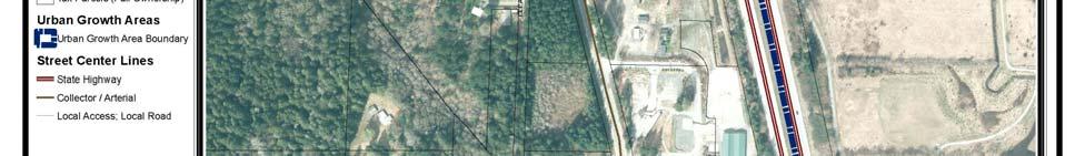
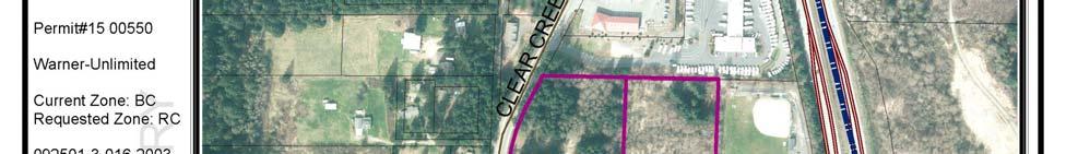
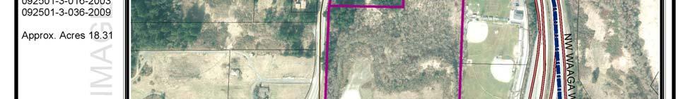
1 STAFF REPORT Permit Number: Unlimited DATE: March 2, 2016 TO: FROM: Kitsap County Board of Commissioners; Kitsap County Planning Commission Katrina Knutson, AICP, Senior Planner, DCD and Jeff Arango, AICP, Senior Associate, BERK Consulting RE: Warner Limited Reclassification Request APPLICATION INFORMATION 1. Applicant Name: Unlimited, Gary C. Warner, Manager (applicant and owner) 2. Parcel Number: and Address or location information: Clear Creek Road NW, Silverdale, WA; see Attachment 1 4. Current Land Use: Undeveloped Land/Water; see Attachment 3 5. Current Comprehensive Plan Map Designation: Urban Industrial 6. Proposed Comprehensive Plan Map Designation: Urban High Intensity/Commercial Mixed Use 7. Current Zoning: Business Center (BC); see Attachment 4 8. Proposed Zoning: Regional Commercial (RC); see Attachment 5 9. Lot Area / Size: acres (according to owner); acres (according to Kitsap County Assessor) 10. Comprehensive Plan Alternatives: Request included with Comprehensive Plan Update 2016 Supplemental Environmental Impact Statement (SEIS) Alternatives 2 and Preferred Alternative: The request is included in the Preferred Alternative. Submitted Application Materials Project Application Environmental Checklist Vicinity Map 1
2 Application Request The applicant is requesting a Comprehensive Plan Map amendment from Urban Industrial to Urban High Intensity Commercial/Mixed Use and a rezone from Business Center (BC) to Regional Commercial (RC). BACKGROUND The site is undeveloped and largely covered by designated wetlands, potential wetlands, hydric soils and associated buffers. Two subject parcels both contain regulated critical areas. The larger, southerly parcels has been cleared and graded. The remaining parcel areas are wetlands, stream corridor and forested. The parcels lies within a Category II Critical Aquifer Recharge Area as described in Kitsap County Code Title 19 (Critical Areas) Chapter 600. Surrounding Zoning and Land Use The property is currently designated Urban Industrial on the Comprehensive Plan Map and is zoned BC. The subject property is adjacent to Regional Commercial, Highway Tourist Commercial, Government and Services, and Rural Residential zoning. Surround areas contain a variety of land uses: cultural/recreational, trade, undeveloped land/water, and residential. Surrounding Areas Exhibit 1. Summary of Surrounding Areas Current Zoning and Land Use Current Zoning North Highway Tourist Commercial Trade Current Land Use East Rural Residential (RR) Cultural/Recreational South RC Transportation/Roads West RC Undeveloped Land/Water and Residential Source: Kitsap County, 2015; BERK, 2015 Present Comprehensive Plan and Zoning Designations Current Comprehensive Plan and Zoning Designations The subject property is currently designated as Urban Industrial on the Comprehensive Plan Map and BC on the zoning maps. The Comprehensive Plan describes the Urban Industrial designation as: Urban Industrial. This designation includes both industrial and business uses, such as light manufacturing, hi tech, warehousing, bio tech, park like business, 4 year educational institutions, equipment and vehicle repair, as well as heavy industrial activities and those requiring access to major transportation corridors. Zones that implement the Urban Industrial designation include: Business Center, Business Park, Industrial, and Airport. The Comprehensive Plan (and zoning code) describes the BC zone as: Business Center (BC): This zone provides for integrated groupings of light industrial uses including but not limited to bio tech, 4 year educational institutions, light manufacturing, hi tech, warehousing, equipment and vehicle repair, and compatible commercial and office uses that primarily serve their needs. Integrated groupings of small to medium sized businesses within an attractive, park like setting are encouraged. This zone allows for flexibility in the amount of space within each individual business dedicated to office use, warehousing and/or light manufacturing operations. 2
3 Proposed Comprehensive Plan and Zoning Designations The proposed Comprehensive Plan Map designation is Urban High Intensity Commercial/Mixed Use. The current Comprehensive Plan describes the Urban High Intensity Commercial/Mixed Use designation as: Urban High Intensity Commercial/Mixed Use. This designation primarily focuses on larger commercial centers, including commercial uses that require large sites and draw customers at the community and regional scale. Examples of commercial uses appropriate to this designation include but are not limited to superstores, department stores, automotive parts and sales, home improvement stores, hotels and motels, and restaurants. Mixed use developments incorporating residential units are also appropriate in this designation. Zones that implement the Urban High Intensity Commercial/Mixed Use designation include: Highway Tourist Commercial, Regional Commercial, and Mixed Use. Regional Commercial (RC): This zone is used for commercial centers that provide for the shopping and service needs of the entire region. Generally these centers will contain two or more major department stores along with several shops of the same kind for comparative shopping, and will also attract free standing commercial services that take advantage of the center's customer traffic. Residential units are allowed. (10 30 du/ac) Some residential uses are allowed in the RC zone and not in the BC zone. An array of commercial uses is allowed in both zones with greater allowances for retail in RC. Industrial uses are a focus of the BC zone. Exhibit 2. Selected Allowed Uses (KCC ) Selected Uses RC (proposed zoning) BC (current zoning) Residential Uses Single family dwelling, detached X X Multi family dwelling ACUP X Mixed use development ACUP X Hotel/motel P X Commercial/Business Uses Financial, banking, mortgage and title institutions P P General office and management services 4,000 to 9,999 s.f. P P General retail merchandise stores less than 4,000 s.f. P P General retail merchandise stores 10,000 to 24,999 s.f. P X General retail merchandise stores 25,000 s.f. or greater ACUP X Research Laboratory X P Restaurants P P Tourism facilities, including outfitter and guide facilities P P Industrial Uses Manufacturing and Fabrication, medium X P Warehousing and Distribution X P 3
4 Storage, Hazardous Materials X C Legend: P = Permitted, X = Prohibited, ACUP = Administrative Conditional Use, C = Conditional There are minimal development standards in the BC zone in terms of lot configurations; density is not addressed since residential uses are not allowed. The maximum height is the same in both zones. Exhibit 3. Selected Development Standards Comparison (KCC ) Density and Dimensions RC (proposed zoning) BC (current zoning) Base/Maximum density (du/acre) 10 NA Maximum Density 30 NA Minimum lot size (acre) NA NA Lot width (feet) NA NA Lot depth (feet) NA NA Maximum height (feet) PUBLIC COMMENTS This is a summary of comments received. For full text comments, please visit project page: One public commenter states support due to proximity to other commercially zoned properties. EVALUATION Site specific reclassification requests to the Comprehensive Plan must be reviewed in accordance with the criteria outlined in the Kitsap County Code (KCC) Chapter Applicable review criteria for site specific reclassification requests are in sections KCC A and KCC D. General Criteria (KCC A) A. General. For each proposed amendment to the Comprehensive Plan the review authority, the planning commission in reaching its recommendation, and the board of commissioners in making its decision, shall develop findings and conclusions, which demonstrate: 1. How circumstances related to the proposed amendment and/or the area in which the property affected by the proposed amendment is located have substantially changed since the adoption of the Comprehensive Plan or applicable development regulations; Circumstances related to the proposed amendment or area in which the property is located has changed since the adoption of the Comprehensive Plan or development regulations. The County has updated its buildable lands analysis showing there is a capacity deficit for both population and employment in the Silverdale UGA under present designations and boundaries. See Exhibit How the assumptions upon which the Comprehensive Plan is based are no longer valid, or there is new information available which was not considered during the adoption of, or during the last annual amendment to, the Comprehensive Plan or development regulations; and 4
5 The assumptions upon which the Comprehensive Plan is based are still generally valid. Updated capacity analysis has been conducted as part of the 2016 Comprehensive Plan update, see Exhibit 5 below. 3. How the requested redesignation is in the public interest and the proposal is consistent with the Kitsap County Comprehensive Plan. The County aims to focus a greater share of growth into the urban areas, which may include rezoning properties within the existing UGA boundary to increase capacity as necessary to accommodate growth targets. See reclassification request criteria D.1.2 below for analysis regarding consistency with the Comprehensive Plan. Reclassification Request Criteria (KCC D) D. Site Specific Amendments. In addition to the findings and conclusions in subsection (A) of this section, a proposed site specific map amendment may be recommended for approval by the planning commission and may be approved by the board of commissioners if the following findings are made: 1. All Site Specific Amendment Requests. Each of the following requirements must be satisfied for a recommendation for approval. The assumptions upon which the Comprehensive Plan is based are still generally valid. Updated capacity analysis has been conducted as part of the 2016 Comprehensive Plan update, see Exhibit 4 below. a. The proposed amendment meets concurrency requirements for transportation, sewer and water, and will not result in significant adverse impacts on adopted level of service standards for other public facilities and services, such as police, fire and emergency medical services, park services, and general government services; The subject property is located within the Silverdale Urban Growth Area (UGA) and is currently zoned for a wide range of commercial uses. Since the property is already within the UGA the County already has an obligation to provide urban public services. Project specific impacts from proposed future development will be addressed during local permitting. Sewer gravity lines would need extension by a developer to the site for about 1,000 feet. A nearby pump station is being upgraded in the County s sewer plans; the County would confirm at the time of development if existing pump stations are sufficient or if a new pump station would be needed (BHC 2015). Based on the 2006 Comprehensive Plan EIS and 2012 EIS, the area has been evaluated cumulatively for urban uses and appropriate road improvements identified in the County s UGAs including Silverdale; the area is under review again in the 2016 SEIS. The site is located adjacent to a segment of Clear Creek Road NW with projected 2036 deficiencies under Alternative 2, although no existing deficiencies or Alternative 3 deficiencies are identified. However, the transportation improvement projects identified to address Alternative 2 deficiencies expected without the proposal, would also be expected to address the contribution to the cumulative impact resulting from the proposal. Further any reclassification request development would be subject to the County s transportation concurrency requirements. Kitsap Transit currently services the area. b. The proposed amendment is consistent with the balance of the goals, policies and objectives of the current Kitsap County Comprehensive Plan and reflects the local circumstances of the County; The County aims to focus a greater share of growth into the urban areas, which may include rezoning properties within the existing UGA boundary to increase capacity as necessary to accommodate growth targets. 5
6 Kitsap County Comprehensive Plan Vision Statements Kitsap County s Comprehensive Plan includes vision statements that direct policy for commercial use. See Exhibit 4. Exhibit 4. County Vision for Economic Development and Urban Areas Vision Economic Development. A stable, prosperous and diversified economy that provides living wage jobs for residents, supported by adequate land for a range of employment uses and that encourages accomplishment of local economic development goals. Urban Areas. Healthy urban areas that are the region's centers for diverse employment and housing opportunities, all levels of education, and civic and cultural activities. Source: Kitsap County Comprehensive Plan (December 2012). Relationship to Vision Identify land for commercial and industrial development, and allows for a variety of uses and development types on those lands. Provide the land use capacity for employment growth, allowing for new businesses and expansion of existing businesses Foster housing and population growth in urban areas. Identify land for commercial, industrial and business development, and allows for a variety of uses and development types on those lands. Encourage the creation of mixed use neighborhoods. The applicant proposes a rezone from BC to RC in an area with a variety of existing commercial land uses. The proposed amendment would increase the range of land uses that are allowed on the property and in the immediate neighborhood. The wider range of uses that are allowed in the RC District, including housing, may allow for further economic development and provide for housing and jobs within proximity. The subject property does possess intact wetland areas, and any future development under the present or proposed designations and zones would be reviewed pursuant to the development standards found in Kitsap County Code Title 19 (critical Areas) which includes but is not limited to requiring mitigation sequencing including avoidance and minimization of impacts to the functions and values of critical areas and their buffers.. The parcels contain areas without mapped wetlands as well as areas that have undergone clearing and grading. An updated wetland delineation would likely be required prior to any future development. Kitsap County Comprehensive Plan Goals and Policies The proposed zoning amendment supports the following current Comprehensive Plan Goals: Goal 3. Enact and implement reasonable measures to ensure that growth in urban areas is consistent with Plan growth targets. o Policy LU 9 Consider the need, based on the findings of the Buildable Lands Program, to further evaluate or increase the amount or rate of growth in urban areas, or to modify the County s development regulations to ensure that urban growth does not occur in the rural area. The proposed amendment is consistent with the above goal and policy because it would result in increased housing and employment capacity in the Silverdale UGA, which is currently undersized to meet updated growth targets. 6
7 Exhibit 5. Silverdale UGA Adjusted Population and Employment Allocations Adjusted Growth Target No Action Alternative Growth Difference with Target Alternative 2 Growth Difference with Target Alternative 3 Growth Difference with Target Population 8,723 7,644 (1,079) 8, , Employment 8,928 6,801 (2,127) 10,924 1,996 9, Source: Countywide Planning Policies for Kitsap County; US Census 2010; Kitsap County and Cities Permits; BERK Goal 19. Encourage industrial activities and their related land uses as a means to create new jobs and improve the overall tax base of Kitsap County. o Policy LU 106 Maintain an industrial lands inventory report that identifies vacant land without major natural limitations, and which is or could be zoned for industrial use. The proposed amendment would result in a reduction of lands designated for industrial use in the Silverdale UGA, but would result in an increase in employment capacity. In accordance with the Kitsap County Buildable Lands methodology the square footage per employee is 969 square feet in the BC Zone and 500 square feet in the RC Zone. The RC Zone also allows residential and mixed use development that is not prohibited in the BC Zone. The County has options to increase industrial lands capacity in other areas should it be necessary to provide enough land for industrial use Economic Development Goals and Policies Goal 3. Identify a sufficient amount of land and variety of sites for residential, commercial and industrial land uses that are reasonably scaled to the needs of the County and communities within the County. o Policy ED 21. Focus most commercial growth within Urban Growth Areas where most of the County s future population growth will be guided and where public services and facilities will be focused. The property is already zoned for industrial and commercial use, and a zone change would allow for a different range of commercial uses including large scale retail. The property is within the Silverdale UGA boundary and focusing growth there, especially employment growth, in proximity to residential areas is consistent with County goals. Goal 16. Provide a sufficient amount of land and variety of sites for commercial land uses that are reasonably scaled to the needs of the community and ensure a convenient and adequate supply of goods and services to the residents of the County as well as the traveling public. o o Policy LU 74 Designate sufficient land for anticipated commercial land uses on the Land Use Map, considering countywide population, employment forecasts, and the local needs of the surrounding community. Policy LU 75 Provide suitable opportunities for commercial and service activities within the urban areas and encourage intensive development of these areas. The Silverdale UGA is currently undersized to accommodate the new population and employment targets. The proposed amendment would increase both population and employment capacity in the Silverdale UGA and support mixed use development consistent with County goals. 7
8 c. The subject parcel(s) is suitable for the requested land use designation based upon, but not limited to, access, provision of utilities, consistency with existing and planned uses, environmental constraints and compatibility with the neighborhood; The subject property is suitable for the requested land use designation and is consistent with adjacent properties that are already zoned RC. The site does have existing environmental constraints. Any proposed future development would require a wetland delineation and other related actions as required under Kitsap County Code Title 19 (Critical Areas). This would include any considerations required under Category II Critical Aquifer Recharge Areas under the same code title. d. The proposed amendment does not materially affect the land uses and growth projections which are the basis for comprehensive planning, and reflects local circumstances in the county; The Silverdale UGA needs greater housing and employment capacity to accommodate growth targets during the planning period under the current Comprehensive Plan (No Action). The proposed amendment increases housing and jobs capacity in the Silverdale UGA without expanding the boundary of the UGA. The proposed amendment is included in both Alternatives 2 and 3 that are being analyzed in the Comprehensive Plan Environmental Statement (EIS). e. The proposed amendment does not materially affect the adequacy or availability of urban facilities and services to the immediate area or the overall area of the urban growth area; The subject property is already within the Silverdale UGA and therefore the County has an obligation to ensure that the property can be served by urban services. The subject property is already zoned for urban commercial development and while the range of uses that are allowed would change under the proposed amendment, a similar level of service is required under the existing and proposed zoning. The cumulative demand for services was analyzed in the 2006 Comprehensive Plan and 2012 Comprehensive Plan UGA Sizing and Composition Remand; the areas is now under review in the Comprehensive Plan Update 2016 Alternatives 2 and 3. See also D.1.a above. f. The proposed amendment is consistent with the GMA, Kitsap County wide Planning Policy, state and local laws and other applicable inter jurisdictional policies or agreements. The following state and local policies and laws are applicable to the applicant s zoning amendment request. Growth Management Act Planning Goals (RCW 36.70a.020) (1) Urban growth. Encourage development in urban areas where adequate public facilities and services exist or can be provided in an efficient manner. The subject property is currently within the Silverdale UGA and is served by adequate public facilities and services to support new growth. The site was evaluated for employment growth cumulatively with other properties in the 2012 Comprehensive Plan Remand and is likewise included in the 2012 Capital Facilities Plan. (2) Reduce sprawl. Reduce the inappropriate conversion of undeveloped land into sprawling, lowdensity development. The subject property is within the Silverdale UGA where existing development is already characterized as urban with appropriate urban facilities. The proposed amendment would allow for a different range of land uses than under the current BC Zoning, including large scale retail, residential, and mixed use development that is not characterized as sprawl. (5) Economic development. Encourage economic development throughout the state that is consistent with adopted comprehensive plans, promote economic opportunity for all citizens of 8
9 this state, especially for unemployed and for disadvantaged persons, promote the retention and expansion of existing businesses and recruitment of new businesses, recognize regional differences impacting economic development opportunities, and encourage growth in areas experiencing insufficient economic growth, all within the capacities of the state's natural resources, public services, and public facilities. The proposed amendment would increase employment capacity and allow for residential and mixeduse development consistent with RC Zoning. The proposed amendment would also reduce the amount of land for industrial development in the Silverdale UGA. Assuming there is a surplus of industrial land or other more suitable locations the proposed amendment would support the County s economic development goals. Based on a review of the existing land use and development in the surrounding area there appears to be other industrial lands that could support additional development (See Attachment 4Attachment 4. Current Zoning). Kitsap County wide Planning Policies Element B. Urban Growth Areas 3. Coordinated Growth management in Urban Growth Areas e. For Urban Growth Areas: i. The County should plan with associated cities and local communities to address land uses, infrastructure needs, level of service standards as identified in these policies, and other issues as needed. The results should be reflected in the County Comprehensive Plan. ii. The County should provide a level of urban facilities and services consistent with the County s ability and appropriateness to provide such services for those Urban Growth Areas that will be associated with a specific city or that will eventually incorporate. The subject property is already within the Silverdale UGA and the County has demonstrated an ability to provide urban facilities and services to the area. The site was evaluated for employment growth cumulatively with other properties in the 2012 Comprehensive Plan Remand and is likewise included in the 2012 Capital Facilities Plan. The proposed amendment would change the types of employment land uses that are permitted, and newly allow the possibility of residential uses, but a similar level of urban services will be necessary to support development in accordance with the Comprehensive Plan and standards of the RC zone. 2. All Site Specific Amendment Requests Regarding Parcels Located Within an Associated Urban Growth Area (Including UGA Expansions of Associated Urban Growth Areas). Each of the following requirements must be satisfied for a recommendation for approval: a. Demonstration from the jurisdiction affiliated with the UGA that the proposal has the capability and capacity to provide urban level services to the area. The subject property is currently within the Silverdale UGA, which is under the jurisdiction of Kitsap County. The County has the ability to provide urban level of services to all properties within the Silverdale UGA. See description under criteria 1.f above. The proposed amendment would allow for larger scale retail uses in comparison to the existing BC Comprehensive Plan Map and zoning designation. b. Demonstration that the proposal is consistent with the associated urban growth area jurisdiction s Comprehensive Plan. 9
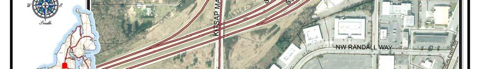
10 The proposed amendment is generally consistent with the Kitsap County Comprehensive Plan, but requires an amendment to the Comprehensive Plan Map from Urban Industrial to Urban High Intensity Commercial/Mixed Use. c. Demonstration that the proposal meets the affiliated jurisdiction s transportation standards. The proposed amendment is included in Alternatives 2 and 3 for the 2036 Comprehensive Plan Update, which will include transportation analysis to assess future conditions and transportation impacts. Findings of Fact 1. The applicant, Gary C. Warner, submitted the amendment application to Kitsap County on February 16, 2015, The applicant seeks a Comprehensive Plan amendment from Urban Industrial to Urban High Intensity Commercial/Mixed Use and a Zoning Map amendment from Business Center (BC) to Regional Commercial (RC) 3. The subject properties are currently within the Silverdale UGA. 4. The subject properties are currently vacant and undeveloped. 5. The subject properties are approximately acres. 6. The subject properties are adjacent to properties to the west with a future land use and zoning map designation of RC. 7. Kitsap County maps identified wetlands and moderate slope hazards on the subject properties and would be subject to mitigation sequencing for any future development under current or proposed designations. 8. The subject property is already served by urban facilities and services. The site was evaluated for employment growth cumulatively with other properties in the 2012 Comprehensive Plan Remand and is likewise included in the 2012 Capital Facilities Plan. 9. The subject property is located at the intersection of SR 3 and SR 303 with adequate transportation access to serve future development. 10. The amendment request included with Comprehensive Plan Update 2016 Supplemental Environmental Impact Statement (SEIS) Alternatives 2 and The subject parcels possess regulated critical areas and exist within a Category II Critical Aquifer Recharge Area. As such any proposed development resulting from approval of this request would be subject to all applicable laws and code standards, including Kitsap County Code Title 19 (Critical Areas). 12. The request is included in the Preferred Alternative. Conclusion of Law The project is consistent with the provisions of the Washington State Growth Management Act, Kitsap Countywide Planning Policies, the Kitsap County Comprehensive Plan, and the Kitsap County Code. Recommendation Based on the findings of act and conclusion of law staff recommends approval of application #


11 ATTACHMENTS Attachment 1. Aerial Imagery 11
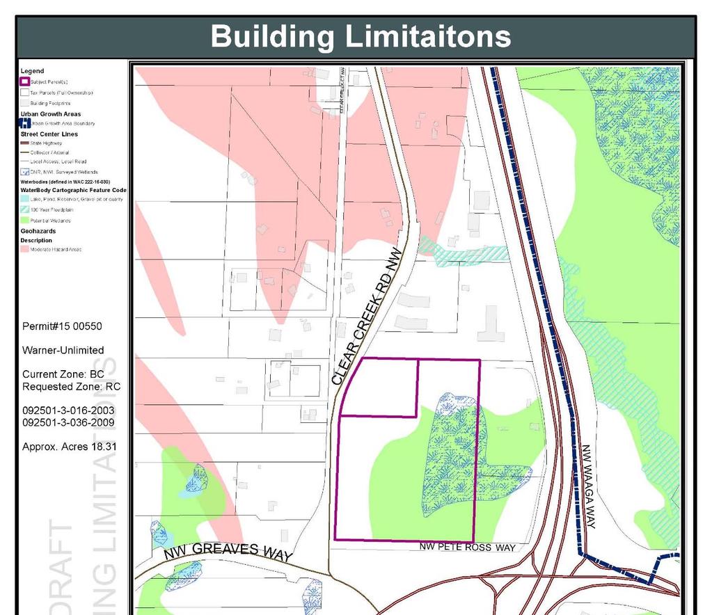
12 Attachment 2. Building Limitations 12
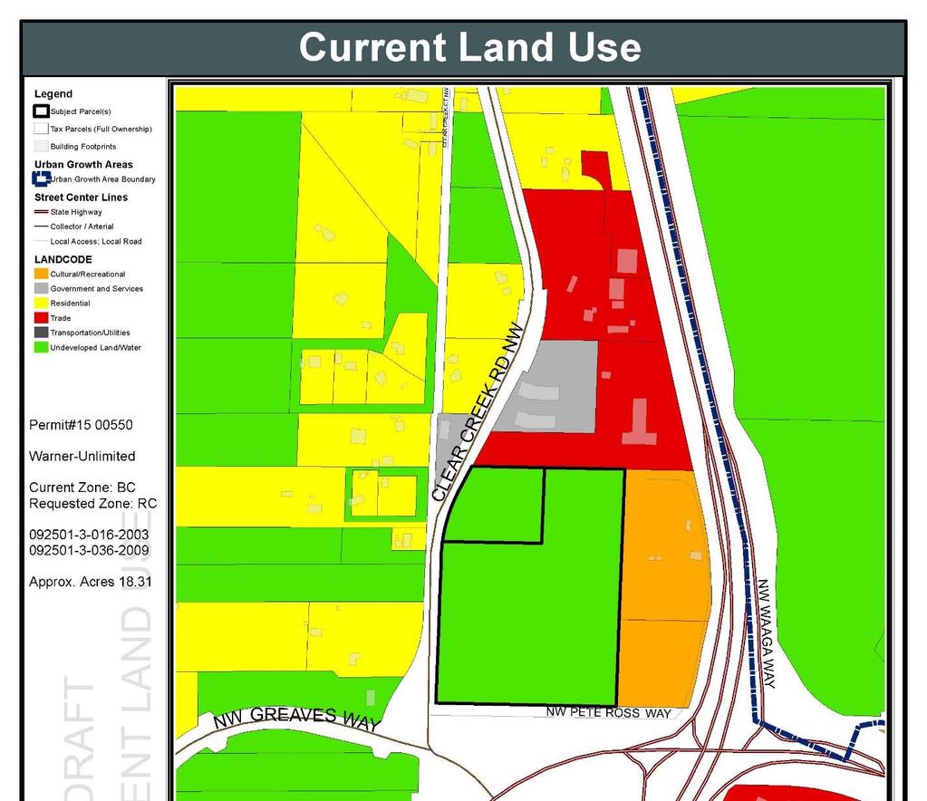
13 Attachment 3. Current Land Use 13
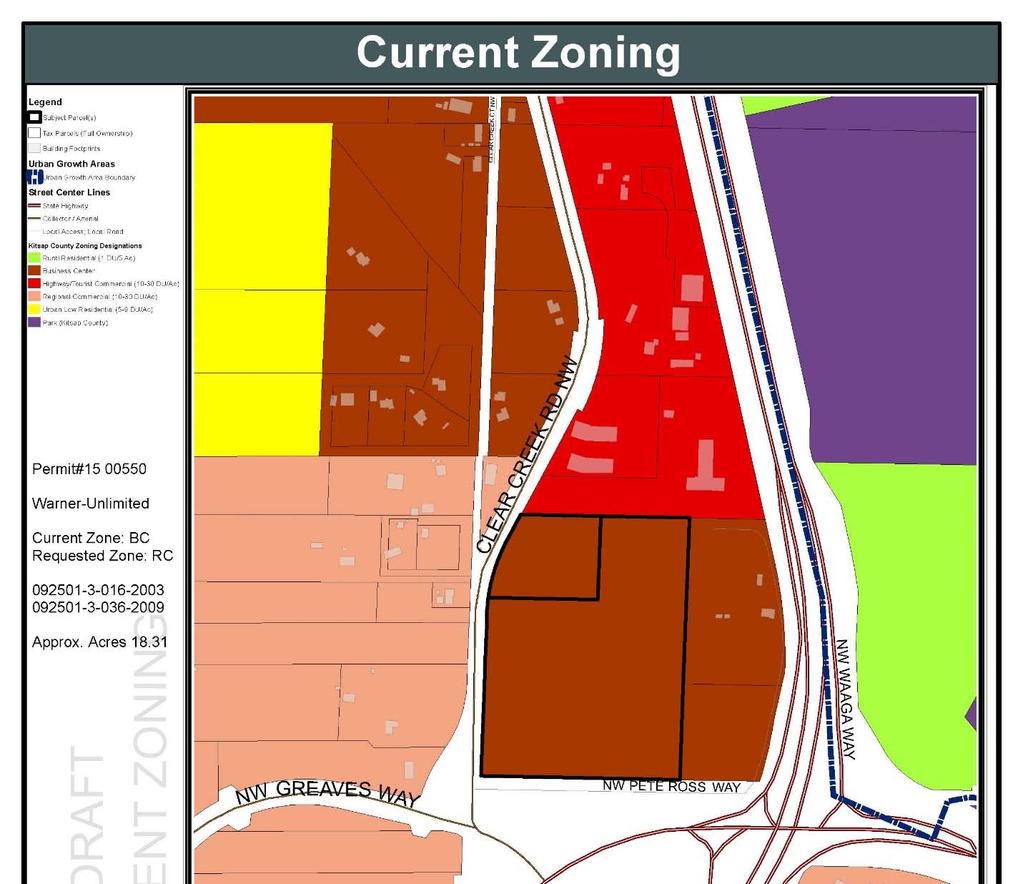
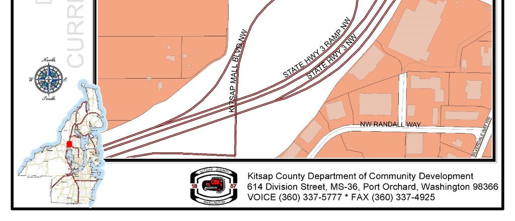
14 Attachment 4. Current Zoning 14
15 Attachment 5. Proposed Zoning 15
STAFF REPORT. Permit Number: Laurier Enterprises, Inc. Kitsap County Board of Commissioners; Kitsap County Planning Commission
 STAFF REPORT Permit Number: 15 00740 Laurier Enterprises, Inc. DATE: November 9, 2015 TO: FROM: Kitsap County Board of Commissioners; Kitsap County Planning Commission Katrina Knutson, AICP, Senior Planner,
STAFF REPORT. Permit Number: Laurier Enterprises, Inc. Kitsap County Board of Commissioners; Kitsap County Planning Commission
 STAFF REPORT Permit Number: 15 00740 Laurier Enterprises, Inc. DATE: December 18, 2015 TO: FROM: Kitsap County Board of Commissioners; Kitsap County Planning Commission Katrina Knutson, AICP, Senior Planner,
STAFF REPORT. Permit Number: Lee. Kitsap County Board of Commissioners; Kitsap County Planning Commission
 STAFF REPORT Permit Number: 15 00689 Lee DATE: March 2, 2016 TO: FROM: Kitsap County Board of Commissioners; Kitsap County Planning Commission Katrina Knutson, AICP, Senior Planner, DCD and Jeff Arango,
STAFF REPORT. Permit Number: Gonzalez. Kitsap County Board of Commissioners; Kitsap County Planning Commission
 STAFF REPORT Permit Number: 15 00657 Gonzalez DATE: March 2, 2016 TO: FROM: Kitsap County Board of Commissioners; Kitsap County Planning Commission Katrina Knutson, AICP, Senior Planner, DCD and Jeff Arango,
STAFF REPORT. Permit Number: Porter. Kitsap County Board of Commissioners; Kitsap County Planning Commission
 STAFF REPORT Permit Number: 15 00461 Porter DATE: November 9, 2015 TO: FROM: Kitsap County Board of Commissioners; Kitsap County Planning Commission Katrina Knutson, AICP, Senior Planner, DCD and Jeff
STAFF REPORT. Permit Number: DJM Construction. Kitsap County Board of Commissioners; Kitsap County Planning Commission
 STAFF REPORT Permit Number: 15 00378 DJM Construction DATE: November 9, 2015 TO: FROM: Kitsap County Board of Commissioners; Kitsap County Planning Commission Katrina Knutson, AICP, Senior Planner, DCD
STAFF REPORT. Permit Number: Garland. Kitsap County Board of Commissioners; Kitsap County Planning Commission
 STAFF REPORT Permit Number: 15 00686 Garland DATE: February 25, 2016 TO: FROM: Kitsap County Board of Commissioners; Kitsap County Planning Commission Katrina Knutson, AICP, Senior Planner, DCD and Jeff
Kitsap County Department of Community Development
 Kitsap County Department of Community Development Staff Report and Recommendation Annual Comprehensive Plan Amendment Process for 2018 George s Corner LAMIRD Boundary Adjustment Report Date 7/16/2018 Hearing
Kitsap County Department of Community Development
 Kitsap County Department of Community Development Staff Report and Recommendation Annual Comprehensive Plan Amendment Process for 2018 Public Facility Designations and Park Classifications Update Report
Permit Number: Edwards Mountain View Meadows
 Notes and comments on 2016 Comp Plan Tom Nevins - Nov 24, 2015 These notes are being prepared prior to any public comment review, public hearing input, or Planning Commission discussion. These are initial
GENERAL DESCRIPTION STAFF RECOMMENDATION IMPLEMENTATION REQUIREMENTS
 Application No.: 891418 Applicant: AREA-WIDE MAP AMENDMENT Rezone two parcels from Moderate Density Single Family (MSF) to Neighborhood Center (NC) and Employment Center (EC). Charles Bitton GENERAL DESCRIPTION
Kitsap County Department of Community Development. Administrative Staff Report
 Kitsap County Department of Community Development Administrative Staff Report Report Date: Application Complete Date: March 15, 2018 Application Submittal Date: March 12, 2018 Project Name: Nikki Lee Salon
Kitsap County Department of Community Development. Notice of Administrative Decision
 Kitsap County Department of Community Development Notice of Administrative Decision Date: March 27, 2018 To: Tammy Mabry, tammystattoostudio@gmail.com Interested Parties and Parties of Record RE: Permit
WENATCHEE PLANNING COMMISSION SCHEDULED MEETING October 15, 2014 WENATCHEE CITY HALL COUNCIL CHAMBERS 129 S. Chelan Avenue Wenatchee, WA AGENDA
 WENATCHEE PLANNING COMMISSION SCHEDULED MEETING October 15, 2014 WENATCHEE CITY HALL COUNCIL CHAMBERS 129 S. Chelan Avenue Wenatchee, WA 98801 AGENDA I. CALL TO ORDER: 5:30 PM II. ADMINISTRATIVE AFFAIRS
Kitsap County Department of Community Development. Staff Report and Administrative Decision
 Kitsap County Department of Community Development Report Date: Staff Report and Administrative Decision Application Complete Date: March 19, 2018 Application Submittal Date: March 19, 2018 To: Seth Hanson,
891941, , : COMPREHENSIVE PLAN AMENDMENT, COMMUNITY PLAN AMENDMENT, AND AREA-WIDE MAP AMENDMENT
 Application Nos. 891941, 891909, 891940: COMPREHENSIVE PLAN AMENDMENT, COMMUNITY PLAN AMENDMENT, AND AREA-WIDE MAP AMENDMENT Amendments to designate five parcels as Rural Industrial Center in the Alderton
Kitsap County Department of Community Development. Administrative Staff Report
 Kitsap County Department of Community Development Administrative Staff Report Report Date: Application Submittal Date: October 25, 2017 Application Complete Date: October 25, 2017 Project Name: John s
STAFF REPORT. Community Development Director PO Box 4755 Beaverton, OR 97076
 STAFF REPORT HEARING DATE: July 7, 2010 TO: Planning Commission STAFF: Jana Fox, Assistant Planner PROPOSAL: Southeast Beaverton Office Commercial Zoning Map Amendment (ZMA2010-0006) LOCATION: The subject
STAFF REPORT And INFORMATION FOR THE HEARING EXAMINER
 KITSAP COUNTY DEPARTMENT OF COMMUNITY DEVELOPMENT 614 DIVISION STREET MS-36, PORT ORCHARD WASHINGTON 98366-4682 Louisa Garbo, Director (360) 337-7181 FAX (360) 337-4925 HOME PAGE - www.kitsapgov.com/dcd/
Procedures For Collecting and Monitoring Data
 DRAFT Kitsap County Buildable Lands Program Procedures For Collecting and Monitoring Data Page 1 12/1/05 Introduction This procedures report is intended to provide guidelines for Kitsap County and its
United States Post Office and Multi-Family Residential; and, Single- Family Residence with an Apartment
 Planning Commission File No.: AME2013 0009 January 9, 2014 Page 2 of 9 Existing Land Use: United States Post Office and Multi-Family Residential; and, Single- Family Residence with an Apartment Surrounding
LETTER OF TRANSMITTAL
 LETTER OF TRANSMITTAL To: Clallam County Board of Commissioners From: Clallam County Planning Commission Date: November 18, 2009 Subject: Transmittal to BOCC: Findings and Conclusions regarding proposed
Final. Chapter Four: Land Use
 Chapter Four: Land Use Purpose and Intent Goals and Policies Existing Land Use Patterns AICUZ Airport Overlay Zone Zoning Existing Land Use Land Use Designations Land Use Demand and Forecast Existing Population
ZONING CLASSIFICATION SUMMARY SHEET
 Growth and Resource Management Planning and Development Services 123 West Indiana Avenue Room 202 DeLand, Florida 32720-4253 Telephone (386) 943-7059 Fax (386) 626-6570 www.volusia.org ZONING CLASSIFICATION
Table 4d-1. City of Poulsbo Residential Building Permits CITY OF POULSBO Unit Type
 City of Poulsbo Growth from 2006-2012 OFM City of Poulsbo Population Estimate Highlights The City of Poulsbo had a 2006 population of 7,722 The City of Poulsbo had a 2012 population of 9,360 Resident population
4.2 LAND USE INTRODUCTION
 4.2 LAND USE INTRODUCTION This section of the EIR addresses potential impacts from the Fresno County General Plan Update on land use in two general areas: land use compatibility and plan consistency. Under
Yakima County Public Services Department Planning Division
 Yakima County Public Services Department Planning Division Yakima County s 2017 Review of its UGAs and Permitted Densities (as required by the Growth Management Act) Urban Growth Area for City of Zillah
Implementation. Approved Master Plan and SMA for Henson Creek-South Potomac 103
 Implementation Approved Master Plan and SMA for Henson Creek-South Potomac 103 104 Approved Master Plan and SMA for Henson Creek-South Potomac Sectional Map Amendment The land use recommendations in the
Staff Report to the Clallam County Planning Commission March 2, 2004 Page 1
 March 2, 2004 Page 1 Comprehensive Plan and Zoning Map Amendment REZ2003-00001, Staff Report Clallam County Department of Community Development January 27, 2004 Prepared by the Clallam County Department
Marion County Board of County Commissioners
 Marion County Board of County Commissioners Date: 12/29/2015 P&Z: 12/28/2015 BCC: 1/12/2016 Item Number 160113Z Type of Application Rezoning Request From: A-1 (General Agriculture) To: PUD (Planned Unit
Kitsap County Department of Community Development. Staff Report
 Kitsap County Department of Community Development Staff Report Report Date: Application Complete Date: August 14, 2017 Application Submittal Date: August 14, 2017 To: Hercules & Laura Hubbell, laura@allcountyoperations.com
2005 COTTAGE GROVE BUILDABLE LANDS ANALYSIS UPDATE
 2005 COTTAGE GROVE BUILDABLE LANDS ANALYSIS UPDATE Adopted June 13, 2005 Prepared by Satre Associates, P.C. Planners, Landscape Architects and Environmental Specialists 132 East Broadway, Suite 536 Eugene,
STAFF REPORT and INFORMATION FOR THE HEARING EXAMINER. Project: Westphal Accessory Dwelling Unit (ADU)
") KITSAP COUNTY DEPARTMENT OF COMMUNITY DEVELOPMENT 614 DIVISION STREET MS-36, PORT ORCHARD WASHINGTON 98366-4682 LARRY KEETON, DIRECTOR (360) 337-7181 FAX (360) 337-4925 HOME PAGE - www.kitsapgov.com STAFF
KITSAP COUNTY DEPARTMENT OF COMMUNITY DEVELOPMENT 614 DIVISION STREET MS-36, PORT ORCHARD WASHINGTON 98366-4682 LARRY KEETON, DIRECTOR (360) 337-7181 FAX (360) 337-4925 HOME PAGE - www.kitsapgov.com STAFF
3.1. OBJECTIVES FOR RESIDENTIAL LAND USE DESIGNATIONS GENERAL OBJECTIVES FOR ALL RESIDENTIAL DESIGNATIONS
 3. RESIDENTIAL LAND USE DESIGNATIONS INTRODUCTION The Residential land use designations provide for housing and other land uses that are integral to, and supportive of, a residential environment. Housing
Planning Department Oconee County, Georgia
 Planning Department Oconee County, Georgia STAFF REPORT REZONE CASE #: 6985 DATE: October 31, 2016 STAFF REPORT BY: Andrew C. Stern, Planner APPLICANT NAME: Williams & Associates, Land Planners PC PROPERTY
Village WASHINGTON TOWNSHIP MASTER PLAN SYNTHESIS. Page 197
 Village P l a n WASHINGTON TOWNSHIP MASTER PLAN SYNTHESIS Page 197 SECTION 11.0 MASTER PLAN SYNTHESIS INTRODUCTION The proposals presented in the various plans result in a graphic synthesis: The Land Use
8Land Use. The Land Use Plan consists of the following elements:
 8Land Use 1. Introduction The Land Use Plan consists of the following elements: 1. Introduction 2. Existing Conditions 3. Opportunities for Redevelopment 4. Land Use Projections 5. Future Land Use Policies
PC Staff Report 11/18/2013 Z Item No. 1-1
 Z-13-00401 Item No. 1-1 PLANNING COMMISSION REPORT Regular Agenda - Public Hearing Item PC Staff Report 11/18/2013 ITEM NO. 1: Z-13-00401 IG (General Industrial) District TO CS (Strip Commercial) District;
Staff Report. Planning Commission Public Hearing: October 17, 2007 Staff Recommendation: Denial
 COUNTY OF PRINCE WILLIAM 5 County Complex Court, Prince William, Virginia 22192-9201 PLANNING (703) 792-6830 Metro 631-1703, Ext. 6830 FAX (703) 792-4401 OFFICE Internet www.pwcgov.org Stephen K. Griffin,
CITY OF NORTH LAS VEGAS MEMORANDUM
 CITY OF NORTH LAS VEGAS MEMORANDUM TO: FROM: SUBJECT: Planning Commission Community Development and Compliance Department # 28 ) AMP-03-15; Coleman Airpark II & III - Comprehensive Plan Amendment (Public
Comprehensive Plan Amendment #PLN , Reserve at Cannon Branch (Coles Magisterial District)
") COUNTY OF PRINCE WILLIAM 5 County Complex Court, Prince William, Virginia 22192-9201 PLANNING (703) 792-7615 FAX (703) 792-4758 OFFICE Internet www.pwcgov.org Christopher M. Price, AICP Director of Planning
COUNTY OF PRINCE WILLIAM 5 County Complex Court, Prince William, Virginia 22192-9201 PLANNING (703) 792-7615 FAX (703) 792-4758 OFFICE Internet www.pwcgov.org Christopher M. Price, AICP Director of Planning
Mohave County General Plan
 63 64 65 66 67 68 69 70 71 The Land Use Diagram is not the County's zoning map. 13 It is a guide to future land use patterns. Zoning and area plan designations may be more restrictive than the land use
CITY OF DURHAM DURHAM COUNTY NORTH CAROLINA. Zoning Map Change Report. RR Existing Zoning. Rural Rural Density Residential Site Characteristics
 CITY OF DURHAM DURHAM COUNTY NORTH CAROLINA Zoning Map Change Report Meeting Date: February 26, 2007 Reference Name Arrowhead () Jurisdiction County Proposed Zoning RR Existing Zoning RS-20 Request Proposed
ARTICLE 3: Zone Districts
 ARTICLE 3: Zone Districts... 3-1 17.3.1: General...3-1 17.3.1.1: Purpose and Intent... 3-1 17.3.2: Districts and Maps...3-1 17.3.2.1: Applicability... 3-1 17.3.2.2: Creation of Districts... 3-1 17.3.2.3:
City of Peachtree City. Annexation Review Process
 City of Peachtree City Annexation Review Process Page 1 Annexation Review Process Step One: Initial annexation information The following information is to be completed by the property owner and/ or their
MASTER INTERLOCAL AGREEMENT FOR GROWTH MANAGEMENT ACT IMPLEMENTATION IN YAKIMA COUNTY TABLE OF CONTENTS
 MASTER INTERLOCAL AGREEMENT FOR GROWTH MANAGEMENT ACT IMPLEMENTATION IN YAKIMA COUNTY TABLE OF CONTENTS I. PREAMBLE A. Purpose... 1 B. Background... 2 II. AGREEMENT A. Parties to Agreement... 3 B. Authority...
Land Use Planning Analysis. Phase 2 Drayton Valley Annexation Proposal
 Land Use Planning Analysis Phase 2 Drayton Valley Annexation Proposal Prepared for Town of Drayton Valley Prepared by Mackenzie Associates Consulting Group Limited March, 2011 TABLE OF CONTENTS 1.0 INTRODUCTION...
HOUSING & RESIDENTIAL AREAS
 CHAPTER 10: HOUSING & RESIDENTIAL AREAS OVERVIEW With almost 90% of Ridgefield zoned for residential uses, the patterns and form of residential development can greatly affect Ridgefield s character. This
13 Sectional Map Amendment
 13 Sectional Map Amendment Introduction This chapter reviews land use and zoning policies and practices in Prince George s County and presents the proposed zoning in the sectional map amendment (SMA) to
Pierce County Comprehensive Plan Review
 2015-2016 Pierce County Comprehensive Plan Review March 16, 2016 Introduction Planning and Management Policies Some of the policies governing both the planning and management of growth and change within
Kitsap County Department of Community Development 619 Division Street, MS-36 Port Orchard, WA 98366
 Kitsap County Department of Community Development 619 Division Street, MS-36 Port Orchard, WA 98366 ACKNOWLEDGEMENTS Kitsap County Board of Commissioners District 1 Robert Gelder District 2 Charlotte Garrido
Bylaw No , being "Official Community Plan Bylaw, 2016" Schedule "A" DRAFT
 Bylaw No. 2600-2016, being "Official Community Plan Bylaw, 2016" Schedule "A" Urban Structure + Growth Plan Urban Structure Land use and growth management are among the most powerful policy tools at the
City of Astoria Comprehensive Plan URBAN GROWTH
 URBAN GROWTH CP.110 CP.110. Background Summary. Astoria has a population of 9,477 (2010 US Census). The total land area within the Urban Growth Boundary (UGB) is 3,474.2 acres with total land area of 4,450
Glades County Staff Report and Recommendation Unified Staff Report for Small Scale Plan Amendment and Rezoning
 Glades County Staff Report and Recommendation Unified Staff Report for Small Scale Plan Amendment and Rezoning CASE NUMBERS: COMP17-02 and RZ17-02 DATE of STAFF REPORT: May 1, 2017 CASE TYPE: Application
Marion County Board of County Commissioners
 Marion County Board of County Commissioners Date: 6/4/217 P&Z: 9/25/217 BCC Transmittal: 1/17/217 BCC Adopt: TBD Amendment No: 217-L6 Type of Application Large-Scale Comp Plan Amendment Request: Change
Kitsap County Hearing Examiner
 January 25, 2016 ADMINISTRATION BUILDING, 619 DIVISION ST, MS-36 PORT ORCHARD, WA 98366 http://www.kitsapgov.com/dcd/lu_env/he/ (360) 337-5777 NOTICE OF HEARING EXAMINER DECISION To: Interested Parties
PROPOSED FINDINGS OF FACT BENDER URBAN GROWTH BOUNDARY EXPANSION AND ANNEXATION REQUEST April 3, Background
 PROPOSED FINDINGS OF FACT BENDER URBAN GROWTH BOUNDARY EXPANSION AND ANNEXATION REQUEST April 3, 2016 Background The owners of TL300, 301, 302, 303, and 304, 3N1027BD - properties abutting the City Limits
Generic Environmental Impact Statement. Build-Out Analysis. City of Buffalo, New York. Prepared by:
 Generic Environmental Impact Statement Build-Out Analysis City of Buffalo, New York 2015 Prepared by: TABLE OF CONTENTS 1.0 INTRODUCTION 1 2.0 METHODOLOGY 2 3.0 EXISTING LAND USE 3 4.0 EXISTING ZONING
2030 General Plan. December 6, 7 pm
 2030 General Plan GPAC Meeting #9 GPAC Meeting #9 December 6, 7 pm City Council Input on Working Draft Land Use Map Council discussed GPAC & PC versions of the working draft land use map 11/28 Council
Executive Summary Land Use 4-A
 Executive Summary Land Use 4-A The Land Use Element looks at how land is currently being used in Blaine, and evaluates the need for new development based on the predicted number of new residents and businesses
Land Use. Land Use Categories. Chart 5.1. Nepeuskun Existing Land Use Inventory. Overview
 Land Use State Comprehensive Planning Requirements for this Chapter A compilation of objectives, policies, goals, maps and programs to guide the future development and redevelopment of public and private
Craig L. Miller, Attorney 230 East Fifth Street Port Angeles, WA 98362
 Comprehensive Plan and Zoning Map Amendment REZ2003-00003, Staff Report Clallam County Department of Community Development Prepared by the Clallam County Department of Community Development, Planning Division
2013 APPLICATION FOR URBAN GROWTH AREA AMENDMENT TO PIERCE COUNTY COMPREHENSIVE PLAN
 2013 APPLICATION FOR URBAN GROWTH AREA AMENDMENT TO PIERCE COUNTY COMPREHENSIVE PLAN An Urban Growth Area Amendment (UGA) is a proposed change or revision to the designated Comprehensive Urban Growth Area
TOTTENHAM SECONDARY PLAN
 TOTTENHAM SECONDARY PLAN AMENDMENT NO. 11 TO THE OFFICIAL PLAN OF THE TOWN OF NEW TECUMSETH The following text and schedules to the Official Plan of the Town of New Tecumseth constitute Amendment No. 11
APPLICATION INFORMATION Site Information Parcel Number Street Address Applicant Information Name Street Address City State Zip
 Comprehensive Plan Amendment City of Puyallup Development Services 333 S. Meridian Puyallup, WA 98371 Phone: 253-864-4165 www.cityofpuyallup.org Submittal Checklist Application is signed and dated 5 Copies
Town of Yucca Valley GENERAL PLAN 1
 Town of Yucca Valley GENERAL PLAN 1 This page intentionally left blank. 3 HOUSING ELEMENT The Housing Element is intended to guide residential development and preservation consistent with the overall values
City of Valdosta Land Development Regulations
 Chapter 206 Section 206-1 Base Zoning Districts Standards for Uses, Structures, and Property Development (B) (C) Principal Uses and Structures. Principal uses and structures permitted in each base zoning
CHAPTER Committee Substitute for Committee Substitute for Senate Bill No. 2188
 CHAPTER 2004-372 Committee Substitute for Committee Substitute for Senate Bill No. 2188 An act relating to land development; amending s. 197.502, F.S.; providing for the issuance of an escheatment tax
PIN , Part 1, Plan SR-713 in Lot 2, Concession 5, Township of McKim (1096 Dublin Street, Sudbury)
") STAFF REPORT Applicant: Dalron Construction Limited Location: PIN 02124-0103, Part 1, Plan SR-713 in Lot 2, Concession 5, Township of McKim (1096 Dublin Street, Sudbury) Official Plan and Zoning By-law:
STAFF REPORT Applicant: Dalron Construction Limited Location: PIN 02124-0103, Part 1, Plan SR-713 in Lot 2, Concession 5, Township of McKim (1096 Dublin Street, Sudbury) Official Plan and Zoning By-law:
Planning Commission Application Summary
 Planning Commission Application Summary Project Name: Ballard Property Rezone Address: 12773 & 12775 South 300 East, 415 East Pheasant View Dr. Current Zoning: RA1 (Residential 40,000 sq. ft. minimum)
Final Draft Ordinance: Matrix
 1. # Topic Title And Description Dry Sewer olicy Use table footnote 48 revised to include a reference to exemptions in K 17.460.0. Allow properties within an Urban Growth Area, that are too far from sewer,
Reviewing Growth Management Planning for Housing
 Washington Research Council BRIEFLY Policy makers should avoid overly proscriptive regulation of the housing market, maximizing opportunities for residential and commercial development that is consistent
Title 6 - Local Government Provisions Applicable to Special Purpose Districts and Other Political Subdivisions
 Title 6 - Local Government Provisions Applicable to Special Purpose Districts and Other Political Subdivisions CHAPTER 29. SOUTH CAROLINA LOCAL GOVERNMENT COMPREHENSIVE PLANNING ENABLING ACT OF 1994 1994
# Coventry Rezoning, Variation and Preliminary/Final PUD Project Review for Planning and Zoning Commission
 #2018-21 460 Coventry Rezoning, Variation and Preliminary/Final PUD Project Review for Planning and Zoning Commission Meeting Date: May 2, 2018 public intro meeting and May 16, 2018 public hearing Requests:
PLANNING & DEVELOPMENT
 PLANNING & DEVELOPMENT STAFF REPORT Rezoning PETITION: APPLICANT: PROPERTY OWNER: TYPE OF REQUEST: SIZE OF TRACT: LOCATION: (#17-22) Rezone from A-PUD (Agri-Business Planned Unit Development) to A-PUD
Planning Justification Report
 Planning Justification Report 103 and 105 Toronto Street Town of Markdale, Municipality of Grey Highlands Maverick Developments November 5, 2016 Zelinka Priamo Ltd. Page i TABLE OF CONTENTS Page No. 1.0
PCRC MEMORANDUM May 15, SUBJECT: Countywide Planning Policies (CPPs) for Urban Growth Area (UGA) Expansions - Options
 for Urban Growth Area (UGA) Expansions - Options") Fife City Hall www.cityoffife.org 5411 23 rd Street East, Fife, WA 98424 Tel (253) 922-2489 Fax (253) 922-5355 PCRC MEMORANDUM May 15, 2014 TO: FROM: Pierce County Regional Council Chris Pasinetti, GMCC
Fife City Hall www.cityoffife.org 5411 23 rd Street East, Fife, WA 98424 Tel (253) 922-2489 Fax (253) 922-5355 PCRC MEMORANDUM May 15, 2014 TO: FROM: Pierce County Regional Council Chris Pasinetti, GMCC
CODE UPDATE: REASONABLE MEASURES Verbal and Written Testimony for August 8, 2016 Public Hearing
 CODE UPDATE: REASONABLE MEASURES Verbal and Written Testimony for August 8, 2016 Public Hearing Numerical Total Issue per Issue Number of Testimony Dry Sewer 1 4 Commitment to Incentives 6 4, 5, 6, 7,
CITY OF MEDFORD COMPREHENSIVE PLAN BUILDABLE LAND INVENTORY
 CITY OF MEDFORD COMPREHENSIVE PLAN PREPARED BY CITY OF MEDFORD PLANNING DEPARTMENT 200 SOUTH IVY STREET MEDFORD, OREGON 97501 BIANCA PETROU, A.I.C.P., ACTING PLANNING DIRECTOR LONG RANGE PLANNING SECTION
ARTICLE VII. NONCONFORMITIES. Section 700. Purpose.
 ARTICLE VII. NONCONFORMITIES. Section 700. Purpose. The purpose of this chapter is to regulate and limit the development and continued existence of legal uses, structures, lots, and signs established either
LAND USE ELEMENT PLAN
 LAND USE ELEMENT PLAN INTRODUCTION: LAND USE ELEMENT PLAN The 2012 Land Use Element Plan guides the direction of the County s planning efforts. It provides the primary direction for achieving the Master
4 LAND USE 4.1 OBJECTIVES
 4 LAND USE The Land Use Element of the Specific Plan establishes objectives, policies, and standards for the distribution, location and extent of land uses to be permitted in the Central Larkspur Specific
PLANNING COMMISSION STAFF REPORT
 PLANNING COMMISSION STAFF REPORT West Capitol Hill Zoning Map Amendment Petition No. PLNPCM2011-00665 Located approximately at 548 W 300 North Street, 543 W 400 North Street, and 375 N 500 West Street
Salem HNA and EOA Advisory Committee Meeting #6
 Salem HNA and EOA Advisory Committee Meeting #6 Residential Land Policies Employment Land Policies Policy Discussions with the Committee Outcome of today s meeting Direction from this Committee on proposed
Table 4b-1. City of Bremerton Building Permits CITY OF BREMERTON: NEW UNITS Type
 City of Bremerton Growth from 2006-2012 OFM City of Bremerton Population Estimate Highlights The City of Bremerton had a 2006 population of 36,202 The City of Bremerton had a 2012 population of 39,650
Midwest City, Oklahoma Zoning Ordinance
 2010 Midwest City, Oklahoma Zoning Ordinance 9/2/2010 Table of Contents Section 1. General Provisions... 5 1.1. Citation... 5 1.2. Authority... 5 1.3. Purpose... 5 1.4. Nature and Application... 5 1.5.
Chapter 4: Housing and Neighborhoods
 Chapter 4: Housing and Neighborhoods Introduction Medina is a growing community that provides a variety of housing types and neighborhood styles while protecting and enhancing the City s open spaces and
Planning Commission Application Summary
 Planning Commission Application Summary Project Name: Creekside Estates Zone Change and Land Use Amendment Address: 571 West 11400 South Current Zoning: RA1 Hearing Date: July 14, 2016 Summary of Request
Article Optional Method Requirements
 Article 59-6. Optional Method Requirements [DIV. 6.1. MPDU DEVELOPMENT IN RURAL RESIDENTIAL AND RESIDENTIAL ZONES Sec. 6.1.1. General Requirements... 6 2 Sec. 6.1.2. General Site and Building Type Mix...
Appendix A: Guide to Zoning Categories Prince George's County, Maryland
 Appendix A: Guide to Zoning Categories Prince George's County, Maryland RESIDENTIAL ZONES 1 Updated November 2010 R-O-S: Reserved Open Space - Provides for permanent maintenance of certain areas of land
CHAPTER 50 LAND USE ZONES ARTICLE 50 BASIC PROVISIONS
 CHAPTER 50 LAND USE ZONES ARTICLE 50 BASIC PROVISIONS 50.010 - PURPOSE The purposes of this chapter are to establish land use zones required to implement the goals and policies of the Klamath County Comprehensive
City of Bellingham Urban Growth Area - Land Supply Analysis Summary
 City of Bellingham Urban Growth Area - Land Supply Analysis Summary Population & Employment Growth Forecasts APPENDIX D, ATTACHMENT 3 The ECONorthwest Whatcom County Population & Economic Forecasts report
O-I (Office-Institutional) and AG-1(Agricultural)
 and AG-1(Agricultural)") PROPERTY INFORMATION ADDRESS 3503 and 3505 Bethany Bend DISTRICT, LAND LOTS 2/1 973 and 974 OVERLAY DISTRICT State Route 9 PETITION NUMBERS EXISTING ZONING O-I (Office-Institutional) and AG-1(Agricultural)
PROPERTY INFORMATION ADDRESS 3503 and 3505 Bethany Bend DISTRICT, LAND LOTS 2/1 973 and 974 OVERLAY DISTRICT State Route 9 PETITION NUMBERS EXISTING ZONING O-I (Office-Institutional) and AG-1(Agricultural)
Dr af t Sant a Bar b ar a Count y Housing Elem ent
 6. LAND INVENTORY AND QUANTIFIED OBJECTIVE I n t r o d u c t i o n This chapter includes two important components of the Housing Element: (1) the land inventory and analysis, and (2) the quantified objective
Chapter 10: Implementation
 Chapter 10: Introduction Once the Comprehensive Plan has been adopted by the City of Oakdale, the City can begin to implement the goals and strategies to make this vision a reality. This chapter will set
GENERAL PLAN UPDATE SPECIFIC AREAS OF THE CITY
 GENERAL PLAN UPDATE SPECIFIC AREAS OF THE CITY Background There are a total of 14 specific areas that are being reviewed as part of the update of the General Plan. Requests to review these areas came from
NOTICE OF HEARING EXAMINER DECISION
 June 20, 2016 ADMINISTRATION BUILDING, 619 DIVISION ST, MS-36 PORT ORCHARD, WA 98366 http://www.kitsapgov.com/dcd/lu_env/he/ (360) 337-5777 cblackburn@co.kitsap.wa.us NOTICE OF HEARING EXAMINER DECISION
Community Facilities (CF) Zone Residential; community centre; post office; bed and breakfast
 Zone Residential; community centre; post office; bed and breakfast") Applicant Land Owner Proposal Municipality of the County of Kings Report to the Centreville Area Advisory Committee Application to Amend the Zoning Map of the Land Use By-law (File 16-18) Date: Wednesday,
Applicant Land Owner Proposal Municipality of the County of Kings Report to the Centreville Area Advisory Committee Application to Amend the Zoning Map of the Land Use By-law (File 16-18) Date: Wednesday,
PLANNING FOR OUR FUTURE
 PLANNING FOR OUR FUTURE ELLSWORTH TOWNSHIP LAND USE AND POLICY PLAN The purpose of this Plan is to serve as a guide for the Township Trustees, Zoning Commission, Board of Zoning Appeals, developers, employers,
CCC XXX Rural Neighborhood Conservation (NC)
") CCC 33.10.XXX Rural Neighborhood Conservation (NC) Purpose: Maintain low density rural residential areas and associated uses commonly found in rural areas consistent with the local character of the distinctive
CCC 33.10.XXX Rural Neighborhood Conservation (NC) Purpose: Maintain low density rural residential areas and associated uses commonly found in rural areas consistent with the local character of the distinctive