Official Zoning Map Amendment Application #2018I-00120
|
|
|
- Tamsin Sullivan
- 5 years ago
- Views:
Transcription
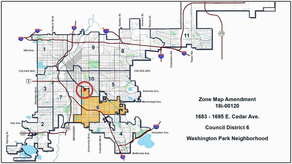
1 Community Planning and Development Planning Services 201 W. Colfax Ave., Dept. 205 Denver, CO p: f: TO: Denver Planning Board FROM: Scott Robinson, Senior City Planner DATE: RE: Official Zoning Map Amendment Application #2018I Staff Report and Recommendation Based on the criteria for review in the Denver Zoning Code, Staff recommends approval for Application #2018I Request for Rezoning Address: 1683, 1685, 1687, 1691, 1693, 1695, & 1699 Cedar Ave. Neighborhood/Council District: Washington Park / Council District 6 RNOs: Washington Park East Neighborhood Association; Inter- Neighborhood Cooperation (INC) Area of Property: 2.45 acres Current Zoning: PUD-G #5 Proposed Zoning: PUD-G #22 Property Owner(s): Multiple, see application Owner Representative: Philipp Stephanus, 1691 Cedar Ave. Summary of Rezoning Request The subject property is located in the Washington Park neighborhood, just south of the Denver Country Club. The site currently has six single-unit homes and common space, including a pool. The applicant is requesting the rezoning to allow for expansion of the existing homes beyond the 2,000 square foot footprint and 6,000 square foot floor area limit per structure. The applicant is requesting a Planned Unit Development (PUD) based on the S-SU-D zone district, with variations that address the site s unique site configuration as a flag lot with minimal frontage on a public right-of-way.

2 Page 2

3 Page 3 Existing Context The subject property is in the Washington Park neighborhood, just south of the Denver Country Club. The property consists of six houses served by a private drive which is accessible from Cedar Avenue. The properties frontage on Cedar Avenue is only about sixty feet wide, but the property widens to over 300 feet wide about 300 feet north of Cedar Avenue. The private drive is the only access to the houses, as the property abuts the Denver Country Club to the north and east. Steele Elementary School is about ¼-mile to the southwest and Washington Park is about ½-mile to the south. There is RTD bus service on Alameda Avenue one block south of Cedar Avenue. The Cherry Creek trail runs along the north and east sides of the Denver Country Club, and the Cherry Creek Shopping Center is about ½-mile as the crow flies to the northeast. The following table summarizes the existing context proximate to the subject site: Existing Building Existing Block, Lot, Existing Zoning Existing Land Use Form/Scale Street Pattern Six single-unit 6 large 2-3 story singleunit houses Site PUD-G #5 houses, common area, pool North OS-B Denver Country Club golf course N/A South of Cedar Ave. and to the west is generally a regular grid of streets with

4 Page 4 South East West Existing Zoning S-SU-D, U-SU-C OS-B, S-SU-D S-SU-D Existing Land Use Single-unit residential Single-unit residential, Denver Country Club Single-unit residential Existing Building Form/Scale Immediately south, north of Cedar Ave., is a very large, 3-story house. South of Cedar Ave. are moderatelysized 1-2 story houses The very large house described above and the golf course Large 2-3 story houses Existing Block, Lot, Street Pattern consistent block sizes and alley access; North of Cedar Ave. and to the east the street grid is interrupted by the Denver Country Club and the streets follow a more disconnected, curvilinear, suburban pattern with driveways and garages accessed from the street. 1. Existing Zoning PUD-G #5 was adopted in 2013 and is based on the S-SU-D zone district. Before the 2010 citywide rezoning, the property was zoned R-1 and was the subject of a planned building group (PBG) that allowed up to seven single-unit structures on the zone lot. The PBG also included a limit to the footprint of each structure of 2,000 square feet, and a limit to the floor area of each
5 Page 5 structure of 6,000 square feet. As part of the 2010 citywide rezoning, the city intended to not rezone properties which were subject to PBGs. However, this property was mistakenly rezoned to S-SU-D. This caused the property to be non-conforming, as the S-SU-D zone district does not allow multiple primary structures on a single zone lot. This oversight was discovered in 2012 and PUD-G #5 was created based on the S-SU-D zone district, but modified to allow up to seven single-unit dwellings on the zone lot. The footprint and floor area limits from the PBG, which are not found in the S-SU-D zone district, were also carried forward as part of PUD-G #5. The PUD also modified the maximum height, up to 36 feet, and changed how height is measured. It also set the front setback at 20 feet, reduced the side interior and rear setbacks to five feet, and introduced a requirement for 3,000 square feet of open space on the zone lot per dwelling unit. Other than these and a few other minor modifications, the standards of the S-SU-D zone district apply. The S-SU-D zone district allows the Suburban House building form, including bulk plane requirements, with uses limited to single-unit residential and some group living and civic, public, and institutional uses. There is no minimum parking requirement for single-unit uses. For additional details of the zone district, see the attached PUD-G #5 and DZC Section The building forms allowed in the existing zone district and the proposed zone district are summarized below. Suburban House Applicable Building Forms Existing District: X PUD-G #5 Proposed District: X PUD-G #22 X signifies an allowed building form and O signifies an allowed building form subject to geographic limitations.


6 Page 6 2. Existing Land Use Map 3. Existing Building Form and Scale Site from the west


7 Page 7 Site entrance/south from Cedar Ave. South from Cedar Ave. East from Cedar Ave. Source: Google Maps West from Cedar Ave. Summary of PUD Request The applicant requests to rezone to PUD-G #22 per DZC Section The purpose of a PUD district is to provide an alternative to conventional land use regulations, combining use, density, site plan, and building form considerations into a single process, and substituting procedural protections for the more prescriptive requirements in the Code. The PUD District is intended to respond to unique and extraordinary circumstances, where more flexible zoning than what is achievable through a standard zone district is desirable and multiple variances, waivers, and conditions can be avoided. PUD-G #22 carries forward the requirements and regulations of PUD-G #5 with three substantive changes: The 2,000 square foot limit to building footprints and the 6,000 square foot limit to gross floor area per dwelling unit have been removed. The designations of front and rear zone lot lines have been clarified. The ability to amend the PUD by subarea, platted lots, or metes and bounds parcels has been added per DZC Section
8 Page 8 There have also been a few technical changes from PUD-G #5 to bring PUD-G #22 up to the city s current standards for PUDs, including adding language on rules of interpretation and vested rights. Otherwise, the modifications to the underlying S-SU-D zone district described above still apply, as do the standards of the S-SU-D zone district where they have not been modified. Summary of City Agency Referral Comments As part of the DZC review process, the rezoning application is referred to potentially affected city agencies and departments for comment. A summary of agency referral responses follows: Assessor: Approved No Response Asset Management: Approved No Response Denver Public Schools: Approved No Response Department of Public Health and Environment: Approved See comments below: Notes. Denver Department of Public Health and Environment (DDPHE) concurs with the rezoning and is not aware of historical environmental concerns on the Property. General Notes: Most of Colorado is high risk for radon, a naturally occurring radioactive gas. Due to concern for potential radon gas intrusion into buildings, DEH suggests installation of a radon mitigation system in structures planned for human occupation or frequent use. It may be more cost effective to install a radon system during new construction rather than after construction is complete. If renovating or demolishing existing structures, there may be a concern of disturbing regulated materials that contain asbestos or lead-based paint. Materials containing asbestos or leadbased paint should be managed in accordance with applicable federal, state and local regulations. The Denver Air Pollution Control Ordinance (Chapter 4- Denver Revised Municipal Code) specifies that contractors shall take reasonable measures to prevent particulate matter from becoming airborne and to prevent the visible discharge of fugitive particulate emissions beyond the property on which the emissions originate. The measures taken must be effective in the control of fugitive particulate emissions at all times on the site, including periods of inactivity such as evenings, weekends, and holidays. Denver s Noise Ordinance (Chapter 36 Noise Control, Denver Revised Municipal Code) identifies allowable levels of noise. Properties undergoing Re-Zoning may change the acoustic environment, but must maintain compliance with the Noise Ordinance. Compliance with the Noise Ordinance is based on the status of the receptor property (for example, adjacent Residential receptors), and not the status of the noise-generating property. Violations of the Noise Ordinance commonly result from, but are not limited to, the operation or improper placement of HV/AC units, generators, and loading docks. Construction noise is exempted from the Noise Ordinance during the following hours, 7am 9pm (Mon Fri) and 8am 5pm (Sat & Sun). Variances for nighttime work are allowed, but the variance approval process requires 2 to 3 months. For variance requests or questions related to the Noise Ordinance, please contact Paul Riedesel, Denver Environmental Health ( ).
9 Page 9 Scope & Limitations: DEH performed a limited search for information known to DEH regarding environmental conditions at the subject site. This review was not intended to conform to ASTM standard practice for Phase I site assessments, nor was it designed to identify all potential environmental conditions. In addition, the review was not intended to assess environmental conditions for any potential right-of-way or easement conveyance process. The City and County of Denver provides no representations or warranties regarding the accuracy, reliability, or completeness of the information provided. Parks and Recreation: Approved No Response Public Works ROW Surveyor: Approved No Comments Development Services Transportation: Approved No Response Development Services Wastewater: Approved See comments below: DS Wastewater approves the subject zoning change. The applicant should note that redevelopment of this site may require additional engineering including preparation of drainage reports, construction documents, and erosion control plans. Redevelopment may require construction of water quality and detention basins, public and private sanitary and storm sewer mains, and other storm or sanitary sewer improvements. Redevelopment may also require other items such as conveyance of utility, construction, and maintenance easements. The extent of the required design, improvements and easements will be determined during the redevelopment process. Please note that no commitment for any new sewer service will be given prior to issuance of an approved SUDP from Development Services. Development Services-Project Coordination: Approved No Response Development Services-Fire Prevention: Approved No Response City Attorney s Office: Approved No Response Public Review Process CPD informational notice of receipt of the rezoning application to all affected members of City Council, registered neighborhood organizations, and property owners: Property legally posted for a period of 15 days and CPD written notice of the Planning Board public hearing sent to all affected members of City Council, registered neighborhood organizations, and property owners: Date 12/11/2018 3/29/2019
10 Page 10 Planning Board public hearing 4/17/2019 CPD written notice of the Land Use, Transportation and Infrastructure Committee meeting sent to all affected members of City Council and registered neighborhood organizations, at least ten working days before the meeting (tentative): Land Use, Transportation and Infrastructure Committee of the City Council moved the bill forward (tentative): 4/19/2019 4/30/2019 Property legally posted for a period of 21 days and CPD notice of the City Council public hearing sent to all affected members of City 5/20/2019 Council and registered neighborhood organizations (tentative): City Council Public Hearing (tentative): 6/10/2019 Summary of Other Public Outreach and Input o Registered Neighborhood Organizations (RNOs) The Washington Park East Neighborhood Association has provided a letter stating they do not object to the proposed rezoning because it will not change the original intent of the PUD and will allow it to align more closely with current zoning requirements. o Other Public Comment As of the date of this staff report, no other public comments have been received. Criteria for Review / Staff Evaluation The criteria for review of this rezoning application are found in DZC, Sections , and , as follows: DZC Section Consistency with Adopted Plans 2. Uniformity of District Regulations and Restrictions 3. Public Health, Safety and General Welfare DZC Section Justifying Circumstances 2. Consistency with Neighborhood Context Description, Zone District Purpose and Intent Statements DZC Section The PUD District is consistent with the intent and purpose of such districts stated in Article 9, Division 9.6 (Planned Unit Development) of the Zoning Code;
11 Page The PUD District and the PUD District Plan comply with all applicable standards and criteria stated in Division 9.6; 3. The development proposed on the subject property is not feasible under any other zone districts, and would require an unreasonable number of variances or waivers and conditions; 4. The PUD District and the PUD District Plan establish permitted uses that are compatible with existing land uses adjacent to the subject property; and 5. The PUD District and the PUD District Plan establish permitted building forms that are compatible with adjacent existing building forms, or which are made compatible through appropriate transitions at the boundaries of the PUD District Plan (e.g., through decreases in building height; through significant distance or separation by rights-of-way, landscaping or similar features; or through innovative building design). 1. Consistency with Adopted Plans The following adopted plans currently apply to this property if the rezoning is approved prior to the anticipated adoption of the Denveright plans (April 22, 2019): Denver Comprehensive Plan 2000 Blueprint Denver (2002) If the proposed map amendment is approved by City Council after the adoption of the Denveright plans (anticipated April 22, 2019), the following plans would apply instead: Denver Comprehensive Plan 2040 Blueprint Denver (2019) Denver Comprehensive Plan 2000 The proposed rezoning is consistent with many Denver Comprehensive Plan 2000 strategies, including: Land Use Strategy 3-B Encourage quality infill development that is consistent with the character of the surrounding neighborhood; that offers opportunities for increased density and more amenities; and that broadens the variety of compatible uses. Legacies Strategy 2-C Identify community design and development issues, and target specific concerns with appropriate controls and incentives. Neighborhoods Strategy 1-A Respect the intrinsic character and assets of individual neighborhoods : Accommodate appropriate infill and development. The proposed map amendment would allow the existing houses in the development to be expanded and maintained or replaced in a manner consistent with the character of the surrounding neighborhood. Also, by allowing up to seven dwelling units on one zone lot where the lot width at the street would not permit splitting into additional zone lots, the proposed PUD would allow an increase in density over what the standard S-SU-D zone district would allow, consistent with the recommendations of Comprehensive Plan Denver Comprehensive Plan 2040 Although the Comprehensive Plan is not yet adopted, it is anticipated to be considered by City Council by the time this map amendment would be at council for public hearing and would be relevant to this

12 Page 12 request. As such, this staff report provides an analysis of the most current public draft of the plan and the proposed rezoning is consistent with many of the draft Denver Comprehensive Plan 2040 strategies, including: Equitable, Affordable, and Inclusive Goal 2 Build housing as a continuum to serve residents across a range of incomes, ages, and needs. Strong and Authentic Neighborhoods Goal 2 Enhance Denver s neighborhoods through highquality urban design. Strong and Authentic Neighborhoods Goal 3 Preserve the authenticity of Denver s neighborhoods and celebrate our history, architecture, and culture. The proposed map amendment would allow the existing character of the development to be maintained, the houses of which form part of the continuum of housing in the neighborhood. The proposed PUD would also allow more appropriate design of houses in the development, contributing to the neighborhood s established character. The rezoning is consistent with Denver Comprehensive Plan 2040 recommendations. Blueprint Denver (2002) According to the 2002 Plan Map adopted in Blueprint Denver, this site has a concept land use of Single Family Residential and is located in an Area of Stability. Future Land Use Single Family Residential areas are primarily composed of single-family homes with densities fewer than 10 units per acre, often less than six units per acre (p. 42). The proposed PUD would allow
13 Page 13 seven single-unit dwellings on 2.45 acres, or less than three units per acre, consistent with the description of Single Family Residential areas. Area of Change / Area of Stability As noted, the site is in an Area of Stability. The goal for Areas of Stability is to identify and maintain the character of an area while accommodating some new development and redevelopment (p.120). The proposed map amendment would replace the existing PUD with a new PUD that is substantially the same, maintaining the character of the development and the neighborhood. Street Classifications Blueprint Denver classifies Cedar Avenue as an Undesignated Local Street, which is influenced less by traffic volumes and tailored more to providing local access. Mobility on local streets is typically incidental and involves relatively short trips at lower speeds to and from other streets (p. 51). The proposed rezoning would allow low-density residential development consistent with the description of an Undesignated Local Street. Use of PUD (Planned Unit Development) Blueprint Denver provides the following policy guidance regarding the use of PUD zoning (p ): Concerns with PUDs are that their widespread proliferation has increased the complexity of regulating land use, and the conditions they place on development sometimes perform poorly and inflexibly once the PUD has been adopted.to reduce the proliferation of zone districts, the city should reclassify obsolete, unbuilt PUDs into more appropriate general zoning categories. To limit the future excess of PUDs, the city should reserve them for special situations and should provide tighter standards that define what type and scale of development will qualify for this zone definition. Consistent with this adopted plan direction, the 2010 Denver Zoning Code put into place stricter zoning standards that limit the use of PUDs to unique and extraordinary circumstances. CPD also changed the way PUDs are written. PUDs are now based on the zoning standards in a specific DZC zone district, with any specific exceptions to the zoning standards listed within the PUD. In this way PUD standards are tightened to now conform to existing zoning standards apart from very specific alterations. The proposed PUD is consistent with this Blueprint Denver plan direction, as it meets the requirement for PUDs only to be used in exceptional situations (See section 6.A below for further description of special circumstances), and is overall consistent with the recommendations of Blueprint Denver Blueprint Denver (2019) Although not yet adopted by City Council, Blueprint Denver 2019 is anticipated to be adopted by City Council by the time this map amendment will be at council for public hearing, therefore it is relevant to this request. The proposed rezoning was reviewed for consistency with the March 28 th LUTI Committee review draft of Blueprint Denver (2019). The draft Blueprint Denver identifies the subject property as part of a Low Residential place within the Suburban Neighborhood Context and provides guidance from the future growth strategy for the city.

14 Page 14 Future Neighborhood Context The subject property is within the Suburban Neighborhood Context. In the Suburban context all intensities of residential development can be found, though generally they are separated from other types and block patterns are generally irregular with curvilinear streets and no alley access. The intensity and scale of uses are dependent upon the surrounding character (p. 190). The proposed PUD is based on S-SU-D, which is within the Suburban context and is intended to promote and protect residential neighborhoods within the character of the Suburban Neighborhood Context (DZC ). The proposed PUD would allow single-unit residential development at an intensity and scale compatible with the surrounding character, consistent with the Blueprint Denver description of the Suburban Neighborhood Context.
15 Page 15 Future Places The Future Places map shows the subject property as Low Residential. Blueprint Denver describes the aspirational characteristics of Low Residential in the Suburban context as generally characterized by single-unit uses on larger lots while there is a mix of attached and detached garage forms. Buildings are typically up to 2.5 stories in height (p. 198). Further guidance is provided on pages for how to use this height guidance to evaluate a rezoning request. Specifically, There may be times when building heights taller than specified are appropriate Factors to consider when applying Blueprint Denver building height guidance may include: Surrounding context, including existing and planned building height (p.66) The proposed PUD based on S-SU-D would allow single-unit residential structures up to 36 feet tall. This is greater than the general guidance provided in the place description, but consistent with the heights of existing buildings in and around the subject property. The proposed PUD would allow single-unit houses on a large lot with appropriately-sized accessory structures, consistent with the Low Residential Place description of Blueprint Denver. Street Types Blueprint Denver 2019 classifies Cedar Avenue as an Undesignated Local. According to the plan, Local streets can vary in their land uses and are found in all neighborhood contexts. They are most often characterized by residential uses and Local streets provide the lowest degree of through travel but the highest degree of property access (p.160). The proposed PUD would allow residential uses along an Undesignated Local, consistent with the description in Blueprint Denver.
16 Page 16 Growth Strategy The subject property is designated as Low Residential and mapped in all other areas of the city in the Blueprint Denver Growth Strategy, which are anticipated to see around 20% of new housing growth and 10% of new employment growth [citywide] by 2040 (p.51). This is a smaller amount of growth intended to strengthen the existing character of our neighborhoods (p. 49). The proposed PUD would allow low-scale residential development, which is appropriate in these areas intended to capture the anticipated residential growth. The proposed map amendment is consistent with the recommendations of Blueprint Denver Custom Zoning Blueprint Denver 2019 provides the following direction on how to limit the use of custom zoning including PUDs: Limit the use of site-specific, customized zoning tools such as Planned Unit Developments (PUDs) and waivers/conditions to unique and extraordinary circumstances. The zoning code offers a wide variety of zone districts that cover the diverse contexts and places of Denver. Custom zoning tools are most effective when a standard zone district does not exist to implement the adopted plans for an area (p. 73). More detail on the challenges of custom zoning is provided on page 73 of the plan. Due to the specific challenges of the site configuration and history of development, as further described in sections 6.A and 6.C below, there is no standard zone district that can address this site s unique and extraordinary circumstances. Therefore, the use of a PUD is consistent with the recommendations of Blueprint Denver Uniformity of District Regulations and Restrictions The proposed rezoning to PUD-G will result in the uniform application of zone district building form, use and design regulations within the unique zone district.
17 Page Public Health, Safety and General Welfare The proposed official map amendment furthers the public health, safety, and general welfare of the City primarily through implementation of the city s adopted land use plans. It will allow the structures on the subject property to be maintained, expanded, or replaced in a manner consistent with the established character of the neighborhood. 4. Justifying Circumstance The application identifies several changed or changing conditions as the Justifying Circumstance under DZC Section A.4, Since the date of the approval of the existing Zone District, there has been a change to such a degree that the proposed rezoning is in the public interest. Such a change may include: Changed or changing conditions in a particular area, or in the city generally. As described in the application, there has been a trend of small, single-unit houses in the surrounding neighborhood being torn down and replaced by larger single-unit houses. As the character of the neighborhood changes, it is in the public interest for the zoning to allow the subject property to evolve as well. The current PUD-G #5 limits the size of the structures on the property so that they are not able to expand. The proposed change in the new PUD-G #22 removing the building size and footprint limits, consistent with the underlying S- SU-D zone district is justified by the changed and changing conditions in the surrounding area. 5. Consistency with Neighborhood Context Description, Zone District Purpose and Intent Statements The proposed PUD is based upon the Suburban neighborhood context. This context generally consists of single-unit and multi-unit residential, commercial strips and centers, and office parks. Single-unit residential consists typically of the Suburban House building form with street-facing garages (DZC, Division 3.1). The proposed map amendment would allow single-unit houses in the Suburban House form, consistent with the Suburban context description. For further analysis of consistency with PUD zone district purpose and intent, see section 6.A of this staff report, below. 6. Additional review criteria for rezoning to PUD district A. The PUD District is consistent with the intent and purpose of such districts stated in Article 9, Division 9.6 (Planned Unit Development) of the Zoning Code; The PUD District is consistent with the intent and purpose of such districts stated in Article 9, Division 9.6 (Planned Unit Development) of the Zoning Code to respond to Unique and extraordinary circumstances where more flexible zoning than what is achievable through a standard zone district is desirable and multiple variances, waivers, and conditions can be avoided. Under DZC B.3, one example of a unique and extraordinary circumstance is where a development site is subject to an existing PUD and rezoning to a new PUD District will bring the site closer to conformance with current zoning regulations and adopted plans. The existing PUD-G #5 includes square footage limits on building footprint and floor area that are not found in the underlying S-
18 Page 18 SU-D zone district. The proposed PUD-G #22 does not include those square footage limits, bringing the site closer to conformance with the S-SU-D zone district. While the proposed PUD-G #22 brings the site into closer conformance with the S-SU-D zone district, it would still require several variances or waivers to the standard zone district to accommodate the development, most notably the number of primary structures allowed on a zone lot or the zone lot width requirement along a named or numbered street if the zone lot were to be split, but also height and setbacks. Section C states A PUD District is not intended as either a vehicle to develop a site inconsistent with the applicable neighborhood context and character, or solely as a vehicle to enhance a proposed development s economic feasibility. The proposed PUD would allow development on the subject property that is consistent with the Suburban Neighborhood context and that furthers the public health, safety, and general welfare of the city, as described above. According to Section D., in return for the flexibility in site design a PUD District should provide significant public benefit not achievable through application of a standard zone district, including but not limited to diversification in the use of land; innovation in development; more efficient use of land and energy; exemplary pedestrian connections, amenities, and considerations; and development patterns compatible in character and design with nearby areas and with the goals and objectives of the Comprehensive Plan. The PUD District and associated development agreement provides significant public benefit including: The proposed PUD provides for a more efficient use of land by allowing up to seven dwelling units on a zone lot that would otherwise only accommodate one dwelling unit. The proposed PUD provides for development patterns compatible in character and design with nearby areas by allowing for structures of a compatible scale with appropriate setbacks and open space requirements. The proposed PUD is compatible with the goals and objectives of the Comprehensive Plan as described above. B. The PUD District and the PUD District Plan comply with all applicable standards and criteria stated in Division 9.6; The proposed PUD District and PUD District Plan comply with the standards and criteria stated in Division 9.6, including those described above and the form and content standards in Section C. The development proposed on the subject property is not feasible under any other zone districts, and would require an unreasonable number of variances or waivers and conditions; As described above, the site would require several variances or waivers to the standard S-SU-D zone district to accommodate the development, most notably the number of primary structures allowed on a zone lot or the zone lot width requirement along a named or numbered street if the zone lot were to be split, but also height and setbacks.
19 Page 19 There is no other zone district which would accommodate the development without variances or waivers. D. The PUD District establishes permitted uses that are compatible with existing land uses adjacent to the subject property; The PUD District proposes uses consistent with those allowed in S-SU-D. These uses are appropriate to apply to a site that is surrounded by open space and single-unit residential uses, including other properties zoned S-SU-D. E. The PUD District establishes permitted building forms that are compatible with adjacent existing building forms, or which are made compatible through appropriate transitions at the boundaries of the PUD District Plan. The PUD District allows building heights and building forms that are compatible with the surrounding neighborhoods. The required setback and bulk plane restrictions ensure appropriate transitions to adjacent properties. Attachments 1. Application 2. PUD-G #22 3. Copy of current PUD-G #5 zoning regulations 4. RNO comment letter
Land Use, Transportation, and Infrastructure Committee of the Denver City Council FROM: Scott Robinson, Senior City Planner DATE: March 22, 2018 RE:
 Community Planning and Development Planning Services 201 W. Colfax Ave., Dept. 205 Denver, CO 80202 p: 720.865.2915 f: 720.865.3052 www.denvergov.org/cpd TO: Land Use, Transportation, and Infrastructure
Land Use, Transportation, and Infrastructure Committee of Denver City Council FROM: Scott Robinson, Senior City Planner DATE: December 6, 2018 RE:
 Community Planning and Development Planning Services 201 W. Colfax Ave., Dept. 205 Denver, CO 80202 p: 720.865.2915 f: 720.865.3052 www.denvergov.org/cpd TO: Land Use, Transportation, and Infrastructure
Staff Report and Recommendation Based on the criteria for review in the Denver Zoning Code, Staff recommends approval for Application #2017I
 TO: Denver Planning Board, Joel Noble, Chair FROM: Theresa Lucero, Senior City Planner DATE: RE: Official Zoning Map Amendment Application #2017I-00163 Staff Report and Recommendation Based on the criteria
Land Use, Transportation, & Infrastructure Committee of the Denver City Council FROM: Chandler Van Schaack, Senior City Planner DATE: July 3, 2018 RE:
 Community Planning and Development Planning Services TO: Land Use, Transportation, & Infrastructure Committee of the Denver City Council FROM: Chandler Van Schaack, Senior City Planner DATE: July 3, 2018
Official Zoning Map Amendment Application #2017I Gaylord Street and York Street Rezoning from U-RH-2.5 to U-RX-3 and U-RX-5
 Community Planning and Development Planning Services 201 W. Colfax Ave., Dept. 205 Denver, CO 80202 p: 720.865.2915 f: 720.865.3052 www.denvergov.org/cpd TO: Denver Planning Board FROM: Elizabeth Weigle,
Denver City Council Land Use, Transportation, and Infrastructure Committee FROM: Courtney Levingston, Senior City Planner DATE: July 26, 2018 RE:
 TO: Denver City Council Land Use, Transportation, and Infrastructure Committee FROM: Courtney Levingston, Senior City Planner DATE: RE: Official Zoning Map Amendment Application #2017I-00151 Staff Report
Block bounded by Newton St., 17 th Ave., Lowell Blvd., and 16 th Ave.; plus Meade Street (evens only)
") Community Planning and Development Planning Services 201 W. Colfax Ave., Dept. 205 Denver, CO 80202 p: 720.865.2915 f: 720.865.3052 www.denvergov.org/cpd TO: Denver Planning Board FROM: Sara White, AICP,
Community Planning and Development Planning Services 201 W. Colfax Ave., Dept. 205 Denver, CO 80202 p: 720.865.2915 f: 720.865.3052 www.denvergov.org/cpd TO: Denver Planning Board FROM: Sara White, AICP,
Official Zoning Map Amendment Application #2017I and 4889 South Quebec Street Rezoning from B-4 with waivers, UO-1, UO-2 to C-MX-20
 Community Planning and Development Planning Services 201 W. Colfax Ave., Dept. 205 Denver, CO 80202 p: 720.865.2915 f: 720.865.3052 www.denvergov.org/cpd TO: Denver Planning Board FROM: Jeff Hirt, Senior
Official Zoning Map Amendment Application #2018I-00067
 Community Planning and Development Planning Services 201 W. Colfax Ave., Dept. 205 Denver, CO 80202 p: 720.865.2915 f: 720.865.3052 www.denvergov.org/cpd TO: Denver Planning Board FROM: Courtney Levingston,
Official Zoning Map Amendment Application #2017I-00094
 Community Planning and Development Planning Services 201 W. Colfax Ave., Dept. 205 Denver, CO 80202 p: 720.865.2915 f: 720.865.3052 www.denvergov.org/cpd TO: Denver Planning Board FROM: Scott Robinson,
Staff Report and Recommendation Based on the criteria for review in the Denver Zoning Code, Staff recommends approval for application #2017I
 TO: Denver City Council, Land Use, Transportation and Infrastructure Committee FROM: Theresa Lucero, Senior City Planner DATE: RE: Official Zoning Map Amendment Application #2017I-00153 Staff Report and
Brad Buchanan, Executive Director, Department of Community Planning and Development
 TO: City Council FROM: Jeff Hirt, Senior City Planner DATE: RE: Official Zoning Map Amendment Application #2017I-00076 3400 Arkins Ct., 3460 Arkins Ct., 1900 35 th St, 1930 35th St., 1950 35 th St Rezoning
Staff Report and Recommendation
 Community Planning and Development Planning Services 201 W. Colfax Ave., Dept. 205 Denver, CO 80202 p: 720.865.2915 f: 720.865.3052 www.denvergov.org/cpd TO: Denver Planning Board FROM: Andrew Webb, Senior
Official Zoning Map Amendment Application #2017I-00090
 Community Planning and Development Planning Services 201 W. Colfax Ave., Dept. 205 Denver, CO 80202 p: 720.865.2915 f: 720.865.3052 www.denvergov.org/cpd TO: Land Use, Transportation, & Infrastructure
Based on the criteria for review in the Denver Zoning Code, Staff recommends approval for Application #2018I
 Community Planning and Development Planning Services 201 W. Colfax Ave., Dept. 205 Denver, CO 80202 p: 720.865.2915 f: 720.865.3052 www.denvergov.org/cpd TO: Denver Planning Board FROM: Chandler Van Schaack,
Request for Rezoning. Current Zoning: Proposed Zoning:
 TO: Denver City Council, Neighborhoods and Planning Committee FROM: Theresa Lucero, Senior City Planner DATE: March 31, 2016 RE: Zoning Map Amendment #2015I-00150 Rezoning from M-RX-5 to I-MX-3 Community
Official Zoning Map Amendment Application #2018I-00095
 Community Planning and Development Planning Services 201 W. Colfax Ave., Dept. 205 Denver, CO 80202 p: 720.865.2915 f: 720.865.3052 www.denvergov.org/cpd TO: Denver Planning Board FROM: Ella Stueve, Senior
REZONING GUIDE. Zone Map Amendment (Rezoning) - Application. Rezoning Application Page 1 of 3. Return completed form to
 - Application. Rezoning Application Page 1 of 3. Return completed form to") Zone Map Amendment (Rezoning) - Application COMMUNITY PLANNING & DEVELOPMENT REZONING GUIDE Rezoning Application Page 1 of 3 PROPERTY OWNER INFORMATION* CHECK IF POINT OF CONTACT FOR APPLICATION Property
Zone Map Amendment (Rezoning) - Application COMMUNITY PLANNING & DEVELOPMENT REZONING GUIDE Rezoning Application Page 1 of 3 PROPERTY OWNER INFORMATION* CHECK IF POINT OF CONTACT FOR APPLICATION Property
this page left intentionally blank DENVER ZONING CODE
 Article 1. GENERAL PROVISIONS this page left intentionally blank Contents ARTICLE 1. GENERAL PROVISIONS DIVISION 1.1 GENERAL...1.1-1 Section 1.1.1 Purpose...1.1-1 Section 1.1.2 Intent...1.1-1 Section 1.1.3
To: S-MX-8 AIO, S-MX-8A AIO, S-MX-12 AIO, C-MX-8 AIO, C-MX-12 AIO, and S-CC-5 AIO
 Community Planning and Development Planning Services 201 W. Colfax Ave., Dept. 205 Denver, CO 80202 p: 720.865.2915 f: 720.865.3052 www.denvergov.org/cpd TO: Denver City Council FROM: Curt Upton, Senior
Article 3. SUBURBAN (S-) NEIGHBORHOOD CONTEXT
 NEIGHBORHOOD CONTEXT") Article 3. SUBURBAN (S-) NEIGHBORHOOD CONTEXT this page left intentionally blank Contents ARTICLE 3. SUBURBAN (S-) NEIGHBORHOOD CONTEXT DIVISION 3.1 NEIGHBORHOOD CONTEXT DESCRIPTION...3.1-1 Section 3.1.1
Article 3. SUBURBAN (S-) NEIGHBORHOOD CONTEXT this page left intentionally blank Contents ARTICLE 3. SUBURBAN (S-) NEIGHBORHOOD CONTEXT DIVISION 3.1 NEIGHBORHOOD CONTEXT DESCRIPTION...3.1-1 Section 3.1.1
PLANNED UNIT DEVELOPMENT & SUBDIVISION STAFF REPORT Date: April 18, 2019
 PLANNED UNIT DEVELOPMENT & SUBDIVISION STAFF REPORT Date: April 18, 2019 DEVELOPMENT NAME SUBDIVISION NAME Springhill Village Subdivision Springhill Village Subdivision LOCATION 4350, 4354, 4356, 4358,
Official Zoning Map Amendment Application #2015I Marion St. Rezoning from U-SU-A1 to U-MX-2x
 Community Planning and Development Planning Services 201 W. Colfax Ave., Dept. 205 Denver, CO 80202 p: 720.865.2915 f: 720.865.3052 www.denvergov.org/cpd TO: Denver City Council FROM: Courtland Hyser,
DZC and DRMC Amendments to Implement 38th and Blake Station Area Height Amendments
 DZC and DRMC Amendments to Implement 38th and Blake Station Area Height Amendments DZC Text Amendment #2 to establish River North Design Overlay (DO-7) / 38 th and Blake Incentive Overlay (IO-1) (CB18-0016)
SUBDIVISION, PLANNED UNIT DEVELOPMENT, ZONING AMENDMENT, & SIDEWALK WAIVER STAFF REPORT Date: July 19, 2018
 SUBDIVISION, PLANNED UNIT DEVELOPMENT, ZONING AMENDMENT, & SIDEWALK WAIVER STAFF REPORT Date: July 19, 2018 NAME SUBDIVISION NAME LOCATION West Mobile Properties, LLC U.S. Machine Subdivision 556, 566,
ARTICLE VII. NONCONFORMITIES. Section 700. Purpose.
 ARTICLE VII. NONCONFORMITIES. Section 700. Purpose. The purpose of this chapter is to regulate and limit the development and continued existence of legal uses, structures, lots, and signs established either
2017I September 7, 2018 fees waived per
 Review Criteria for 3610 and 3612 North Clay Street from PUD #504 to U-TU-B. 1. Consistency with Adopted Plans: The following adopted plans apply to this property: Denver Comprehensive Plan 2000 Blueprint
ZONING AMENDMENT & SUBDIVISION STAFF REPORT Date: November 3, 2016
 ZONING AMENDMENT & SUBDIVISION STAFF REPORT Date: November 3, 2016 APPLICANT NAME SUBDIVISION NAME David Shumer 5955 Airport Subdivision CITY COUNCIL DISTRICT District 6 5955 Airport Boulevard, 754 Linlen
Representative Name. Address. City, State, Zip. Telephone.
 COMMUNITY PLANNING & DEVELOPMENT ~~DENVER... THE MILE HIGH CITY REZONING GUIDE Zone Map Amendment (Rezoning)- Application Rezoning Application Page 1 of 3 Property Owner Name Philip M. Falco Address 730
REZONING GUIDE. Zone Map Amendment (Rezoning) - Application. Rezoning Application Page 1 of 3. Return completed form to
 - Application. Rezoning Application Page 1 of 3. Return completed form to") Zone Map Amendment (Rezoning) - Application COMMUNITY PLANNING & DEVELOPMENT REZONING GUIDE Rezoning Application Page 1 of 3 PROPERTY OWNER INFORMATION* CHECK IF POINT OF CONTACT FOR APPLICATION Property
Zone Map Amendment (Rezoning) - Application COMMUNITY PLANNING & DEVELOPMENT REZONING GUIDE Rezoning Application Page 1 of 3 PROPERTY OWNER INFORMATION* CHECK IF POINT OF CONTACT FOR APPLICATION Property
Staff Report: Date: Applicant: Property Identification: Acreage of Request: Current Zoning of Requested Area: Requested Action: Attached:
 Staff Report: Completed by Jeff Palmer Director of Planning & Zoning Date: November 7, 2018, Updated November 20, 2018 Applicant: Greg Smith, Oberer Land Developer agent for Ronald Montgomery ET AL Property
Official Zoning Map Amendment Application #2015I N. King Street and 3441 W. 39 th Ave Rezoning from PUD 406 to U-SU-B1
 Community Planning and Development Planning Services 201 W. Colfax Ave., Dept. 205 Denver, CO 80202 p: 720.865.2915 f: 720.865.3052 www.denvergov.org/cpd TO: Neighborhoods and Planning Committee FROM:
Staff Report: Date: Applicant: Property Identification: Acreage of Request: Current Zoning of Requested Area: Requested Action: Attached:
 Staff Report: Completed by Jeff Palmer Director of Planning & Zoning Date: November 7, 2018 Applicant: Greg Smith, Oberer Land Developer agent for Ronald Montgomery ET AL Property Identification: Frontage
Public Review of the Slot Home Text Amendment
 Public Review of the Slot Home Text Amendment The proposed amendments to the Denver Zoning Code have been informed by the Slot Home Strategy Report. This document has been developed out of a robust process
REZONING GUIDE. Zone Map Amendment (Rezoning) - Application. Rezoning Application Page 1 of 3. Return completed form to
 - Application. Rezoning Application Page 1 of 3. Return completed form to") COMMUNITY PLANNING & DEVELOPMENT REZONING GUIDE Rezoning Application Page 1 of 3 Zone Map Amendment (Rezoning) - Application PROPERTY OWNER INFORMATION* PROPERTY OWNER(S) REPRESENTATIVE** CHECK IF POINT
COMMUNITY PLANNING & DEVELOPMENT REZONING GUIDE Rezoning Application Page 1 of 3 Zone Map Amendment (Rezoning) - Application PROPERTY OWNER INFORMATION* PROPERTY OWNER(S) REPRESENTATIVE** CHECK IF POINT
REPORT TO PLANNING AND DESIGN COMMISSION City of Sacramento
 REPORT TO PLANNING AND DESIGN COMMISSION City of Sacramento 915 I Street, Sacramento, CA 95814-2671 www.cityofsacramento.org 9 PUBLIC HEARING December 10, 2015 To: Members of the Planning and Design Commission
ARTICLE I ZONE BASED REGULATIONS
 ARTICLE I ZONE BASED REGULATIONS RZC 21.08 RESIDENTIAL REGULATIONS 21.08.290 Cottage Housing Developments A. Purpose. The purpose of the cottage housing requirements is to: 1. Provide a housing type that
AGENDA SLOT HOME EVALUATION & TEXT AMENDMENT. 5:30 - Welcome
 AGENDA 5:30 - Welcome Please sign-in, put a sticker on the map, grab snacks, materials and a seat 5:45 - Staff Presentation 6:15 - Open House Stations Background Information Mixed Use Districts Multi Unit
Krisana Park S Edison Way. Conservation Overlay (Proposed) Preapp 03/04/15
 Preapp 03/04/15") Krisana Park S Edison Way Conservation Overlay (Proposed) Preapp 03/04/15 Request Private property - Both sides of S. Edison Way: 4.25 acres 24 Single Unit Dwellings Existing Context Zoning Existing Zoning:
Krisana Park S Edison Way Conservation Overlay (Proposed) Preapp 03/04/15 Request Private property - Both sides of S. Edison Way: 4.25 acres 24 Single Unit Dwellings Existing Context Zoning Existing Zoning:
PLANNED UNIT DEVELOPMENT & SUBDIVISION STAFF REPORT Date: November 17, 2016
 PLANNED UNIT DEVELOPMENT & SUBDIVISION STAFF REPORT Date: November 17, 2016 DEVELOPMENT NAME SUBDIVISION NAME LOCATION Autonation Ford of Mobile Autonation Ford of Mobile Subdivision 901, 909, and 925
PLANNED UNIT DEVELOPMENT & SUBDIVISION STAFF REPORT Date: July 20, 2017
 PLANNED UNIT DEVELOPMENT & SUBDIVISION STAFF REPORT Date: July 20, 2017 DEVELOPMENT NAME SUBDIVISION NAME LOCATION Rangeline Crossing III Subdivision Rangeline Crossing III Subdivision 5289 Halls Mill
Operating Standards Attachment to Development Application
 Planning & Development Services 2255 W Berry Ave. Littleton, CO 80120 Phone: 303-795-3748 Mon-Fri: 8am-5pm www.littletongov.org Operating Standards Attachment to Development Application 1 PLANNED DEVELOPMENT
ZONING AMENDMENT, PLANNED UNIT DEVELOPMENT & SUBDIVISION STAFF REPORT Date: August 8, 2013
 ZONING AMENDMENT, PLANNED UNIT DEVELOPMENT & SUBDIVISION STAFF REPORT Date: August 8, 2013 NAME SUBDIVISION NAME PV-Magnolia, LLC Twelve Trees Subdivision LOCATION 2860, 2862 and 2866 Pleasant Valley Road
ARTICLE 14 PLANNED UNIT DEVELOPMENT (PUD) DISTRICT
 DISTRICT") ARTICLE 14 PLANNED UNIT DEVELOPMENT (PUD) DISTRICT Section 14.01 Intent. It is the intent of this Article to allow the use of the planned unit development (PUD) process, as authorized by the Michigan Zoning
ARTICLE 14 PLANNED UNIT DEVELOPMENT (PUD) DISTRICT Section 14.01 Intent. It is the intent of this Article to allow the use of the planned unit development (PUD) process, as authorized by the Michigan Zoning
APPLICANT NAME SUBDIVISION NAME DEVELOPMENT NAME LOCATION. CITY COUNCIL DISTRICT Council District 4 PRESENT ZONING PROPOSED ZONING
 SUBDIVISION, PLANNED UNIT DEVELOPMENT, PLANNING APPROVAL, ZONING AMENDMENT, & SIDEWALK WAIVER REQUEST STAFF REPORT Date: February 17, 2010 APPLICANT NAME SUBDIVISION NAME DEVELOPMENT NAME LOCATION David
DAUPHIN CREEK ESTATES SUBDIVISION
 # 12 SUB-000076-2017 DAUPHIN CREEK ESTATES SUBDIVISION Engineering Comments: FINAL PLAT COMMENTS (should be addressed prior to submitting the FINAL PLAT for review and/or signature by the City Engineer):
Denver Zoning Code Amendment General Development Plan Revisions REDLINE PUBLIC REVIEW DRAFT 1/16/19
 Denver Zoning Code Amendment General Development Plan Revisions REDLINE PUBLIC REVIEW DRAFT 1/16/19 This document contains the redlined draft of a proposed text amendment and rules and regulations to revamp
REZONING GUIDE. Zone Map Amendment (Rezoning) - Application. Rezoning Application Page 1 of 3. Return completed form to
 - Application. Rezoning Application Page 1 of 3. Return completed form to") COMMUNITY PLANNING & DEVELOPMENT REZONING GUIDE Rezoning Application Page 1 of 3 Zone Map Amendment (Rezoning) - Application PROPERTY OWNER INFORMATION* PROPERTY OWNER(S) REPRESENTATIVE** CHECK IF POINT
COMMUNITY PLANNING & DEVELOPMENT REZONING GUIDE Rezoning Application Page 1 of 3 Zone Map Amendment (Rezoning) - Application PROPERTY OWNER INFORMATION* PROPERTY OWNER(S) REPRESENTATIVE** CHECK IF POINT
PLANNING COMMISSION STAFF REPORT
 PLANNING COMMISSION STAFF REPORT REZONING CASE: RZ-16-001 REPORT DATE: March 8, 2016 CASE NAME: Trailbreak Partners Rezoning PLANNING COMMISSION DATE: March 16, 2016 ADDRESSES OF REZONING PROPOSAL: 5501
ZONING AMENDMENT & SUBDIVISION STAFF REPORT Date: March 1, 2018
 #13 SUB-000406-2018 & ZON-000407-2018 ZONING AMENDMENT & SUBDIVISION STAFF REPORT Date: March 1, 2018 NAME SUBDIVISION NAME LOCATION Creekside @ Kooiman Dairy Creekside @ Kooiman Dairy Subdivision (South
PLANNED UNIT DEVELOPMENT STAFF REPORT Date: October 19, 2017
 PLANNED UNIT DEVELOPMENT STAFF REPORT Date: October 19, 2017 DEVELOPMENT NAME LOCATION Custom Boat Storage 3975 Demetropolis Road (East side of Demetropolis Road, 0.2± miles South of Halls Mill Road.)
REZONING GUIDE. Zone Map Amendment (Rezoning) - Application. Rezoning Application Page 1 of 3. Return completed form to
 - Application. Rezoning Application Page 1 of 3. Return completed form to") Zone Map Amendment (Rezoning) - Application COMMUNITY PLANNING & DEVELOPMENT REZONING GUIDE Rezoning Application Page 1 of 3 PROPERTY OWNER INFORMATION* CHECK IF POINT OF CONTACT FOR APPLICATION Property
Zone Map Amendment (Rezoning) - Application COMMUNITY PLANNING & DEVELOPMENT REZONING GUIDE Rezoning Application Page 1 of 3 PROPERTY OWNER INFORMATION* CHECK IF POINT OF CONTACT FOR APPLICATION Property
PLANNED UNIT DEVELOPMENT & SUBDIVISION STAFF REPORT August 18, 2016
 PLANNED UNIT DEVELOPMENT & SUBDIVISION STAFF REPORT August 18, 2016 DEVELOPMENT NAME SUBDIVISION NAME Mullinax Ford Subdivision Mullinax Ford Subdivision LOCATION CITY COUNCIL DISTRICT District 6 Southeast
CHAPTER IV IMPLEMENTATION
 CHAPTER IV IMPLEMENTATION Chapter Outline IV. Implementation Page A. Public Works Projects/Public Infrastructure IV-1 1. Facilities Master Plan Overview IV-1 2. Facilities Master Plan Service Standards
Cover Letter with Narrative Statement
 Cover Letter with Narrative Statement March 31, 2017 rev July 27, 2017 RE: Rushton Pointe Residential Planned Unit Development Application for Public Hearing for RPUD Rezone PL2015 000 0306 Mr. Eric Johnson,
Midwest City, Oklahoma Zoning Ordinance
 2010 Midwest City, Oklahoma Zoning Ordinance 9/2/2010 Table of Contents Section 1. General Provisions... 5 1.1. Citation... 5 1.2. Authority... 5 1.3. Purpose... 5 1.4. Nature and Application... 5 1.5.
WESTMINSTER PARK SUBDIVISION
 WESTMINSTER PARK SUBDIVISION Engineering Comments: FINAL PLAT COMMENTS (should be addressed prior to submitting the FINAL PLAT for review and/or signature by the City Engineer): A. Provide all of the required
PLANNED UNIT DEVELOPMENT (PUD)
") SECTION 38.01. ARTICLE 38 PLANNED UNIT DEVELOPMENT (PUD) Purpose The purpose of this Article is to implement the provisions of the Michigan Zoning Enabling Act, Public Act 110 of 2006, as amended, authorizing
SECTION 38.01. ARTICLE 38 PLANNED UNIT DEVELOPMENT (PUD) Purpose The purpose of this Article is to implement the provisions of the Michigan Zoning Enabling Act, Public Act 110 of 2006, as amended, authorizing
TULSA PARK ESTATES SUBDIVISION, RESUBDIVISION OF LOT 6
 TULSA PARK ESTATES SUBDIVISION, RESUBDIVISION OF LOT 6 Engineering Comments: FINAL PLAT COMMENTS (should be addressed prior to submitting the FINAL PLAT for review and/or signature by the City Engineer):
Telephone AC / 21,960 SF G-MU-3 G-MX-3
 Zone Map Amendment (Rezoning) - Application PROPERTY OWNER INFORMATION* CHECK IF POINT OF CONTACT FOR APPLICATION Property Owner Name Siddhartha Rathod Address City, State, Zip Telephone Email COMMUNITY
the conditions contained in their respective Orders until January 1, 2025, at the discretion of the Director of Planning, Property and Development.
 Part 4: Use Regulations Temporary Uses and Structures Purpose the conditions contained in their respective Orders until January 1, 2025, at the discretion of the Director of Planning, Property and Development.
CHAPTER 14 PLANNED UNIT DEVELOPMENTS
 9-14-1 9-14-1 CHAPTER 14 PLANNED UNIT DEVELOPMENTS SECTION: 9-14-1: Purpose 9-14-2: Governing Provisions 9-14-3: Minimum Area 9-14-4: Uses Permitted 9-14-5: Common Open Space 9-14-6: Utility Requirements
City of Valdosta Land Development Regulations
 Chapter 206 Section 206-1 Base Zoning Districts Standards for Uses, Structures, and Property Development (B) (C) Principal Uses and Structures. Principal uses and structures permitted in each base zoning
Glades County Staff Report and Recommendation Unified Staff Report for Small Scale Plan Amendment and Rezoning
 Glades County Staff Report and Recommendation Unified Staff Report for Small Scale Plan Amendment and Rezoning CASE NUMBERS: COMP17-02 and RZ17-02 DATE of STAFF REPORT: May 1, 2017 CASE TYPE: Application
BROADWAY THREE NOTCH ROAD SUBDIVISION
 # 3 SUB-000803-2018 BROADWAY THREE NOTCH ROAD SUBDIVISION Engineering Comments: FINAL PLAT COMMENTS (should be addressed prior to submitting the FINAL PLAT for review and/or signature by the City Engineer):
Rezoning Petition Final Staff Analysis June 18, 2018
 Rezoning Petition 2018-005 Final Staff Analysis June 18, 2018 REQUEST Current Zoning: R-3 (single family residential) Proposed Zoning: R-5(CD) (single family residential, conditional), with five-year vested
ZONING AMENDMENT & SUBDIVISION STAFF REPORT Date: July 9, 2015
 ZONING AMENDMENT & SUBDIVISION STAFF REPORT Date: July 9, 2015 APPLICANT NAME 2513 Dauphin Street, Inc. SUBDIVISION NAME Audubon Place Extension No. 3, Resubdivision of Lots 1-5 LOCATION 2513 Dauphin Street
Bylaw No , being "Official Community Plan Bylaw, 2016" Schedule "A" DRAFT
 Bylaw No. 2600-2016, being "Official Community Plan Bylaw, 2016" Schedule "A" Urban Structure + Growth Plan Urban Structure Land use and growth management are among the most powerful policy tools at the
City Council Land Use, Transportation, and Infrastructure Committee FROM: Jeff Hirt, Senior City Planner DATE: March 9, 2018 RE:
 TO: City Council Land Use, Transportation, and Infrastructure Committee FROM: Jeff Hirt, Senior City Planner DATE: March 9, 2018 RE: Official Zoning Map Amendment #2015I-00168 Community Planning and Development
FREQUENTLY USED PLANNING & ZONING TERMS
 City Of Mustang FREQUENTLY USED PLANNING & ZONING TERMS Abut: Having property lines, street lines, or zoning district lines in common. Accessory Structure: A structure of secondary importance or function
Metropolitan Planning Commission. DATE: April 5, 2016
 TO: FROM: Metropolitan Planning Commission MPC Staff DATE: April 5, 2016 SUBJECT: Petition of Nine Line Inc. Robert McCorkle, Agent PIN: 2-1034-01-002 380.5 Acres Aldermanic District: 5 (Shabazz) County
PLANNING AND ZONING DEPARTMENT
 Town of Minturn Development Review Process: Guide To Planned Unit Developments (Concept Plan) This guide describes the Planned Unit Development Process. This guide should be utilized in conjunction with
In order to permit maximum applicability of the PUD District, PUD-1 and PUD-2 Districts are hereby created.
 ARTICLE III. PUD ned Unit Development Overlay District 205-128. Purpose. The PUD ned Unit Development Overlay District is intended to provide flexibility in the design of planned projects; to encourage
PLANNING COMMISSION STAFF REPORT. Merrimac PLNSUB Planned Development 38 West Merrimac November 9, Request. Staff Recommendation
 PLANNING COMMISSION STAFF REPORT Merrimac PLNSUB2011-00374 Planned Development 38 West Merrimac November 9, 2011 Planning and Zoning Division Department of Community and Economic Development Applicant:
CHAPTER 10 Planned Unit Development Zoning Districts
 CHAPTER 10 Planned Unit Development Zoning Districts Section 10.1 Intent and Purpose The Planned Unit Development (PUD) districts are intended to offer design flexibility for projects that further the
ARTICLE OPTIONAL METHOD REGULATIONS
 ARTICLE 59-6. OPTIONAL METHOD REGULATIONS DIV. 6.1. MPDU DEVELOPMENT IN RURAL RESIDENTIAL AND RESIDENTIAL ZONES SEC. 6.1.1. GENERAL REQUIREMENTS... 6 2 SEC. 6.1.2. GENERAL SITE AND BUILDING T PE MIX...
PLANNING AND ZONING REVIEWS AT THE COUNTY LEVEL
 PLANNING AND ZONING REVIEWS AT THE COUNTY LEVEL Introductions Why do counties review planning and zoning matters? To bring pertinent inter-community and county-wide planning, zoning, site plan and subdivision
Municipal Council has directed staff to report annually on the nature of Variances granted by the Committee of Adjustment.
 Report to Planning and Environment Committee To: Chair and Members Planning & Environment Committee From: George Kotsifas, P. Eng. Managing Director, Development & Compliance Services and Chief Building
Salem HNA and EOA Advisory Committee Meeting #6
 Salem HNA and EOA Advisory Committee Meeting #6 Residential Land Policies Employment Land Policies Policy Discussions with the Committee Outcome of today s meeting Direction from this Committee on proposed
Marcel Williams, MPC Project Planner
 TO: FROM: The Planning Commission MPC Staff DATE: SUBJECT: Petition to Rezone Property Heath Shelton, Owner Jay Maupin, Agent 2026 Habersham Street Aldermanic District: 2, Bill Durrence County Commission
1. Allow a workable, interrelated mix of diverse land uses;
 5-24 PUD Planned Unit Development 5-24.1 Purpose A. The Planned Unit Development (PUD) District is intended to encourage flexible and innovative design in the development of appropriate sites as integrated
PALM BEACH COUNTY PLANNING, ZONING AND BUILDING DEPARTMENT ZONING DIVISION
 PALM BEACH COUNTY PLANNING, ZONING AND BUILDING DEPARTMENT ZONING DIVISION Application No.: CA-2012-00688 Control No.: 2011-00552 Applicant: Garry Bernardo Owners: Garry Bernardo Agent: Frogner Consulting,
Article Optional Method Requirements
 Article 59-6. Optional Method Requirements [DIV. 6.1. MPDU DEVELOPMENT IN RURAL RESIDENTIAL AND RESIDENTIAL ZONES Sec. 6.1.1. General Requirements... 6 2 Sec. 6.1.2. General Site and Building Type Mix...
Planning Rationale in Support of an Application for Plan of Subdivision and Zoning By-Law Amendment
 Planning Rationale in Support of an Application for Plan of Subdivision and Zoning By-Law Amendment The Kilmorie Development 21 Withrow Avenue City of Ottawa Prepared by: Holzman Consultants Inc. Land
Bowie Marketplace Residential Detailed Site Plan Statement of Justification January 13, 2017 Revised February 2, 1017
 Bowie Marketplace Residential Detailed Site Plan Statement of Justification January 13, 2017 Revised February 2, 1017 Submitted on behalf of: BE Bowie LLC 5410 Edson Lane, Suite 220 Rockville, MD 20852
PLANNED UNIT DEVELOPMENT (PUD) AREA PLAN/REZONING REVIEW PROCEDURE
 AREA PLAN/REZONING REVIEW PROCEDURE") PLANNED UNIT DEVELOPMENT (PUD) AREA PLAN/REZONING REVIEW PROCEDURE Professional inquiries will be made to our Township Planning Consultant, Township Engineer, and Township Attorney to get their opinions
PLANNED UNIT DEVELOPMENT (PUD) AREA PLAN/REZONING REVIEW PROCEDURE Professional inquiries will be made to our Township Planning Consultant, Township Engineer, and Township Attorney to get their opinions
TOWNSHIP OF SOLON COUNTY OF KENT, MICHIGAN. Members: Robert Ellick, Fred Gunnell, Mark Hoskins, Mary Lou Poulsen
 As recommended by Planning Commission at its December 27, 2017 meeting TOWNSHIP OF SOLON COUNTY OF KENT, MICHIGAN At a regular meeting of the Township Board of the Township of Solon, Kent County, Michigan,
ARTICLE 24 SITE PLAN REVIEW
 ARTICLE 24 SITE PLAN REVIEW 24.1 PURPOSE: The intent of these Ordinance provisions is to provide for consultation and cooperation between the land developer and the Township Planning Commission in order
CREEKSIDE TOWNHOMES Chevy Chase, Maryland Site Plan No Preliminary Plan No
 +1 (301) 656 5901 info@nova-habitat.com CREEKSIDE TOWNHOMES Chevy Chase, Maryland Site Plan No. 820160050 Preliminary Plan No. 120160130 Application Statement of Justification October 28, 2015 Nova-Habitat,
THE WHEELER BUILDING SUBDIVISION
 THE WHEELER BUILDING SUBDIVISION Engineering Comments: FINAL PLAT COMMENTS (should be addressed prior to submitting the FINAL PLAT for review and/or signature by the City Engineer): A. Provide all of the
SUBDIVISION DESIGN PRINCIPLES AND STANDARDS
 SECTION 15-200 SUBDIVISION DESIGN PRINCIPLES AND STANDARDS 15-201 STREET DESIGN PRINCIPLES 15-201.01 Streets shall generally conform to the collector and major street plan adopted by the Planning Commission
PALM BEACH COUNTY PLANNING, ZONING AND BUILDING DEPARTMENT ZONING DIVISION ZONING COMMISSION VARIANCE STAFF REPORT 06/05/2014
 PALM BEACH COUNTY PLANNING, ZONING AND BUILDING DEPARTMENT ZONING DIVISION ZONING COMMISSION VARIANCE STAFF REPORT 06/05/2014 APPLICATION NO. ZV-2013-03120 CODE SECTION REQUIRED PROPOSED VARIANCE (V1)
Staff Report PLANNED DEVELOPMENT. Salt Lake City Planning Commission. From: Lauren Parisi, Associate Planner; Date: December 14, 2016
 Staff Report PLANNING DIVISION COMMUNITY & NEIGHBORHOODS To: Salt Lake City Planning Commission From: Lauren Parisi, Associate Planner; 801-535-7932 Date: December 14, 2016 Re: 1611 South 1600 East PLANNED
WESTMINSTER PARK PLACE SUBDIVISION
 WESTMINSTER PARK PLACE SUBDIVISION Engineering Comments: FINAL PLAT COMMENTS (should be addressed prior to submitting the FINAL PLAT for review and/or signature by the City Engineer): A. Provide all of
DEVELOPMENT DEPARTMENT STAFF REPORT THE PARK AT 5 TH
 DEVELOPMENT DEPARTMENT STAFF REPORT ARB Meeting Date: July 3, 2018 Item #: _PZ2018-293_ THE PARK AT 5 TH Request: Site Address: Project Name: Parcel Number: Applicant: Proposed Development: Current Zoning:
Chapter 100 Planned Unit Development in Corvallis Urban Fringe
 100.100 Scope and Purpose. Chapter 100 Planned Unit Development in Corvallis Urban Fringe (1) All applications for land divisions in the Urban Residential (UR) and Flood Plain Agriculture (FPA) zones within
TOOELE COUNTY LAND USE ORDINANCE CHAPTER 31 Page 1
 CHAPTER 31 PLANNED COMMUNITY ZONE (P-C) Section 31-1 Definitions. 31-2 Purpose. 31-3 Land use districts. 31-4 P-C zone area minimum requirements. 31-5 Permitted uses. 31-6 Conditional uses. 31-7 Planning
CHAPTER XVIII SITE PLAN REVIEW
 CHAPTER XVIII SITE PLAN REVIEW Section 18.1 Section 18.2 Description and Purpose. The purpose of this chapter is to provide standards and procedures under which applicants would submit, and the Township
ZONING AMENDMENT & SUBDIVISION STAFF REPORT Date: March 7, 2013
 # 4 & 5 SUB2012-00141 & ZON2012-03157 HOLDOVER ZONING AMENDMENT & SUBDIVISION STAFF REPORT Date: March 7, 2013 APPLICANT NAME SUBDIVISION NAME LOCATION Garrard Development Services, LLC Michigan & Bay