ATTACHMENT #1 SUMMARY CHART
|
|
|
- Eugene Mills
- 5 years ago
- Views:
Transcription
1
2 ATTACHMENT #1 SUMMARY CHART
3 Item # Amendment To: Nature of Proposed Amendment PCM PCM PCM PCM LMA LMA LMA PCT PCT PCT FUTURE LAND USE MAP Parkway Place FUTURE LAND USE MAP PetroSouth FUTURE LAND USE MAP FSU Health Clinic FUTURE LAND USE MAP Chabad House FUTURE LAND USE MAP Capital Circle Light Industrial FUTURE LAND USE MAP East Mahan FUTURE LAND USE MAP Barcelona Offices LAND USE ELEMENT Science & Innovation and Industry & Mining Land Uses MOBILITY ELEMENT Regional Mobility Plan Maps INTERGOVERNMENTAL COORDINATION ELEMENT Comprehensive Plan Amendment Process From: Residential Preservation To: Suburban 0.41 acres From: Urban Residential-2 To: Suburban 0.6 acres From: Educational Facilities and Recreation/Open Space To: Government Operational 1.79 acres From: Residential Preservation To: University Transition 3.71 acres From: Urban Fringe To: Suburban 3.8 acres From: Urban Fringe To: Rural 232 acres From: Urban Residential-2 To: Suburban 30 acres New land use categories that address research and development and innovation districts, and industrial, light industrial, and mining uses. Update the Adopted Cost Feasible Map and replace the project specific Adopted Cost Feasible Maps with project lists. Update Objective 1.8 and Policy addressing the Comprehensive Plan Amendment Process. MATRIX FOR 2018 CYCLE AMENDMENTS Planning Staff Recommendation LPA Recommendation A A A A A A A A AM (Approve with Expansion Area) AM (Approve with Expansion Area) AM (Approve with Expansion Area) AM (Approve with Expansion Area) A = Approve D = Denial AM = Approve as Modified Board/Commission Position A AM (Approve with Expansion Area) AM (Approve with Expansion Area) A A A A A A A A A A A A A Continued Status Small Scale Map Amendment Adopted February 27, 2018 Small Scale Map Amendment Adopted February 27, 2018 Small Scale Map Amendment Adopted February 27, 2018 Large Scale Map Amendment Transmitted February 27, 2018 Small Scale Map Amendment Adopted February 27, 2018 Large Scale Map Amendment Transmitted February 27, 2018 Large Scale Map Amendment Transmitted February 27, 2018 Text Amendment Transmitted February 27, 2018 Text Amendment Transmitted February 27, 2018 Continued to March LPA Public Hearing
4 ATTACHMENT #2 EXECUTED ORDINANCES ADOPTING SMALL-SCALE PLAN AMENDMENTS
5
6
7
8
9
10
11
12
13

14
15
16
17
18
19
20 ATTACHMENT #3 ADOPTED AMENDMENTS
21 Map Amendment PCM Acres From: Residential Preservation To: Suburban Staff Recommendation: Approval Local Planning Agency: Approval City Commission and Board of County Commissioners: Approval

22 PCM201801: Parkway Place Current Future Land Use Map Designation Current Designation Residential Preservation Proposed Future Land Use Map Designation Proposed Designation Suburban
23 Map Amendment PCM Acres From: Urban Residential-2 To: Suburban Staff Recommendation: Approval Local Planning Agency: Approval City Commission and Board of County Commissioners: Approval
24 PCM201802: PetroSouth Current Future Land Use Map Designation Current Designation Urban Residential-2 Proposed Future Land Use Map Designation Proposed Designation Suburban
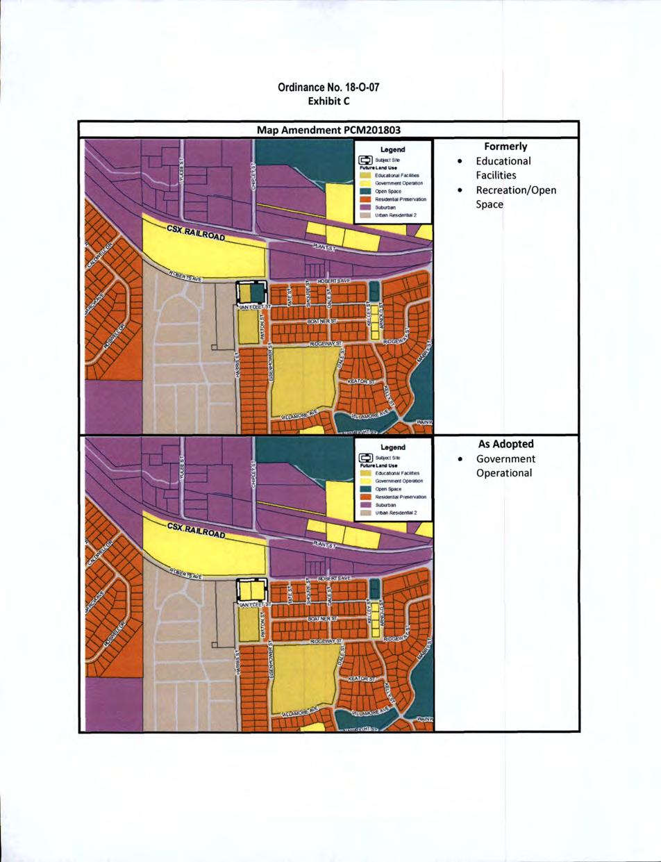
25 Map Amendment PCM Acres From: Educational Facilities and Recreation/Open Space To: Government Operational Staff Recommendation: Approval Local Planning Agency: Approval City Commission and Board of County Commissioners: Approval
26 PCM201803: FSU Health Clinic Current Future Land Use Map Designation Current Designation Educational Facilities Recreation/Open Space Proposed Future Land Use Map Designation Proposed Designation Government Operational
27 Map Amendment LMA Acres From: Urban Fringe To: Suburban Staff Recommendation: Approval Local Planning Agency: Approval Board of County Commissioners and City Commission: Approval
28 LMA201802: Capital Circle Light Industrial Current Future Land Use Map Designation Current Designation Urban Fringe Proposed Future Land Use Map Designation Proposed Designation Suburban
29 ATTACHMENT #4 OTHER SUPPORTING INFORMATION

30 2018 Comprehensive Plan Amendment Cycle PCM Parkway Place/Apalachee Parkway SUMMARY Property Owners: Property Location: TLCPD Recommendation: Parkway Place Partners, Limited Applicant: At the intersection of Apalachee Parkway and Approve Albritton Drive Parkway Place Partners Ltd. TLCPD Staff: Current Future Land Use & Zoning: LPA Recommendation: Debra Thomas Future Land Use: Residential Preservation Zoning: Residential Preservation 2 and Residential Preservation 1 Contact Information: Proposed Future Land Use & Zoning: Approve debra.thomas@talgov.com Future Land Use: Suburban Zoning: Commercial Parkway Date: October 27, 2017 Updated: March 1, 2018
31 PCM201801: Parkway Place/Apalachee Parkway Page 2 of 13 A. REASON FOR REQUESTED CHANGE The subject site is approximately 0.41 acres of a 1.31 acre parcel. The subject site is a portion of an existing shopping center. The applicant stated that his reason for the amendment request is to bring the shopping center into zoning conformity that is reflective of its commercial nature and consistency with the remainder of the shops in the center. This is the only property in the center that is not commercially designated or zoned. The conditions of the area today are significantly different than they were in 1984; this area along this segment of Apalachee Parkway has completed its transition to commercial except for this one storefront in the shopping center. As a residentially-zoned property in a single storefront in this otherwise commercial building, it has no utility. All the conditions of the 1984 Limited Use Site Plan remain in place today [Attachment #1] as it relates to impact adjoining residential properties. The amendment and rezoning would permit the applicant to market the storefront to commercial interests rather than residential only. B. CURRENT AND PROPOSED FUTURE LAND USE DESIGNATION The subject site is currently designated Residential Preservation on the Future Land Use Map (FLUM). The proposed amendment would change the FLUM designation of the site to Suburban. The following maps illustrate the current and proposed FLUM designations for the subject site.
32 PCM201801: Parkway Place/Apalachee Parkway Page 3 of 13 Current Future Land Use Map Designation Current Designation Residential Preservation (RP) Proposed Future Land Use Map Designation Proposed Designation Suburban (Sub)
33 PCM201801: Parkway Place/Apalachee Parkway Page 4 of 13 C. STAFF RECOMMENDATION Find that the proposed Future Land Use Map amendment is consistent with the Tallahassee-Leon County Comprehensive Plan, based on the findings and other information contained in this staff report, and recommend ADOPTION of the proposed amendment. Find that the proposed rezoning is consistent with the Tallahassee-Leon County Comprehensive Plan, based on the findings and other information contained in this staff report, and recommend APPROVAL of the proposed rezoning. D. LOCAL PLANNING AGENCY (LPA) RECOMMENDATION Find that the proposed Future Land Use Map amendment is consistent with the Tallahassee-Leon County Comprehensive Plan, based on the findings and other information contained in this staff report, and recommend ADOPTION of the proposed amendment. Find that the proposed rezoning is consistent with the Tallahassee-Leon County Comprehensive Plan, based on the findings and other information contained in this staff report, and recommend APPROVAL of the proposed rezoning. E. SUMMARY OF FINDINGS Staff presents the following findings of fact: 1. The proposed amendment is consistent with and furthered the intent of Land Use Policy which establishes the Suburban future land use category. This category recognizes the way much of Tallahassee-Leon County has developed since the 1940s. It is intended to create an environment for economic investment or reinvestment through the mutually advantageous placement of employment and shopping opportunities with convenient access to low to medium density residential land uses. The Suburban category also predominantly consists of single-use projects. The subject site is located near medium and low density residential areas, shopping, and employment centers, which is consistent with the intent of the category. The proposed land and zoning is consistent with the development patterns near the subject site and the current retail development on the subject site parcel. 2. The subject site does not meet the description or intent of the Residential Preservation future land use category. The Residential Preservation category is incompatible within the shopping center. 3. This amendment will unify a single parcel under one future land use category and one zoning district. 4. The proposed amendment reinstates the commercial use designation that was in place prior to the 1992 City-wide rezoning. 5. The proposed amendment has no adverse impact on existing or planned infrastructure. 6. The Commercial Parkway district is intended to be located in areas designated Suburban on the future land use map of the comprehensive plan and shall apply to areas exhibiting an existing development pattern of office, general commercial, community facilities, and
34 PCM201801: Parkway Place/Apalachee Parkway Page 5 of 13 intensive automotive commercial development abutting urban area arterial roadways with high traffic volumes. F. STAFF ANALYSIS History and Background The subject site consists of one storefront within the Parkway Place shopping center located north of Apalachee Parkway. The shopping center was built in The 0.41-acre subject site was rezoned from R-1 (Single Family Residential) to C-2 (General Commercial) with Limited Use with Site Plan in The remainder of the shopping center where the subject site is located was already zoned C-2 (General Commercial). The owners of the shopping center agreed to the Limited Use with Site Plan (LUSP) component of the rezoning to address concerns residential property owners to the east and north. The structural conditions put in place at the time of the limited use site plan (e.g. building orientation, buffers, etc.) remain in place today. The subject site remained in C-2 (LUSP) zoning district until 1992, when the City Zoning Code was amended to reflect the Future Land Use Map (FLUM) designations of the newly adopted Comprehensive Plan. In 1990, the Comprehensive Plan changed the subject site to the Residential Preservation FLUM. The zoning was changed to Residential Preservation-2 (RP-2) to implement the Residential Preservation FLUM designation of the site. These designations were inconsistent with the existing development on the site and the adjoining retail uses. Current and Proposed Future Land Use Categories The complete Comprehensive Plan policies for existing FLUM categories, Residential Preservation (Land Use Policy 2.2.3) and proposed FLUM category, Suburban (Land Use Policy 2.2.5), are included as Attachment #2. Residential Preservation (Current) The subject site is currently designated Residential Preservation (RP) on the Future Land Use Map. Policy of the Land Use Element of the Comprehensive Plan outlines the intent and typical uses associated with the RP land use category. The RP land use category is characterized by existing homogeneous residential areas within the community predominantly accessible by local streets. The primary function of this category is to protect existing stable and viable residential areas from incompatible land use intensities and density intrusions. Future development primarily will consist of infill due to the built-out nature of the areas. Commercial, office, and industrial land uses are prohibited. Future arterial and/or expressways should be planned to minimize impacts within this category. Single family, townhouse and cluster housing may be permitted within a range of up to six units per acre. Consistency with surrounding residential type and density shall be a major determinant in granting development approval. The subject site does not meet the description or intent of the Residential Preservation future land use category. Residential Preservation Analysis The following analysis evaluates whether the subject site is consistent with the characteristics of the Residential Preservation land use category.
35 PCM201801: Parkway Place/Apalachee Parkway Page 6 of 13 A) Existing land use within the area is predominantly residential. Analysis: The site is developed as a commercial shopping center. The shopping center was built in B) Majority of traffic is local in nature. i) Predominance of residential uses front on local streets. Analysis: The site is accessed by Apalachee Parkway, a Principle Arterial. ii) Relatively safe internal mobility. Analysis: The subject site is a shopping center that wraps around a parking lot. C) Densities within the area generally are six (6) units per acre or less. Analysis: The site is developed as a commercial shopping center. The shopping center was built in There are no residential units on the subject site. D) Existing residential type and density exhibits relatively homogeneous patterns. Analysis: The site is developed as a commercial shopping center. The shopping center was built in There are no residential units on the subject site. E) Assessment of stability of the residential area, including but not limited to: i) Degree of home ownership. Analysis: The site is developed as a commercial shopping center. The shopping center was built in There are no residential units on the subject site. ii) Existence of neighborhood organizations. Analysis: The site is developed as a commercial shopping center. The shopping center was built in There are no residential units on the subject site. As such, the subject site is not part of a neighborhood organization. Suburban (Proposed) The proposed FLUM designation for the subject site is Suburban. The Suburban land use category allows for a wide range of uses, including housing (up to twenty dwelling units per acre), retail/office, and light industrial. Land Use Element Policy outlines the intent of the Suburban land use category, which is to create an environment for economic investment or reinvestment through the mutually advantageous placement of employment and shopping opportunities with convenient access to low to medium density residential land uses. Policy also states that allowed uses within Suburban are regulated by zoning districts which implement the intent of the category, and which recognize the unique land use patterns, character, and availability of infrastructure in its different areas. The subject site s proposed Suburban FLUM designation is consistent with the development of the subject site and nearby properties along Apalachee Parkway, a principle arterial. The subject site adjoins existing Suburban designated property.
36 PCM201801: Parkway Place/Apalachee Parkway Page 7 of 13 Consistency with Comprehensive Plan The proposed amendment is consistent with the following goals, objectives, and policies of the Tallahassee-Leon County Comprehensive Plan. The complete text of these policies is included as Attachment #3. Policy of the Land Use Element identifies several criteria against which Future Land Use Map and zoning changes must be evaluated. Such changes must be evaluated for consistency with the adopted goals, objective and policies of the Comprehensive Plan as well as consistency with and the furtherance of the intent of the requested future land use category. The proposed amendment is consistent with the intent of Land Use Policy which establishes the Suburban future land use category. This category recognizes the way much of Tallahassee-Leon County has developed since the 1940s. It is intended to create an environment for economic investment or reinvestment through the mutually advantageous placement of employment and shopping opportunities with convenient access to low to medium density residential land uses. The Suburban category also predominantly consists of single-use projects that are interconnected whenever feasible. The subject site consists of a single use project. The subject site is also near shopping and employment opportunities and is served by transit, sidewalks, and central water and sewer, all of which promote the intent of the Suburban land use category. Policy [L] states that Future Land Use Map densities and intensities are intended to reflect the availability of capital infrastructure. The proposed map amendment would reflect the availability of capital infrastructure. Policy [L] requires that higher density and mixed-use development and its ancillary activities shall be channeled into locations which have proper access to the existing transportation system; minimal environmental constraints; sufficient stormwater treatment capacity; compatible existing land use and readily available sewer and water infrastructure. The subject site has access to all urban services and infrastructure. Zoning A rezoning application will be processed concurrently with this map amendment, if approved. A zoning change from Residential Preservation-2 and Residential Preservation-1 to Commercial Parkway is being requested to implement the proposed amendment to the Future Land Use Map. The Land Development Code sections for the current zoning district of Residential Preservation-2 (Section ) and the proposed zoning district of Commercial Parkway (Section ) are included as Attachment #4. The current Residential Preservation-2 (RP-2) zoning district allows low density residential in the form of single family and two-family dwellings up to a maximum density of six (6) dwelling units per acre. It also allows passive and active recreation, community services, and light infrastructure. Under this zoning district, commercial, retail, office and industrial activities are not permissible. The current Residential Preservation-1 (RP-1) zoning district allows low density residential in the form of single family and two-family dwellings up to a maximum density of 3.6 dwelling units per acre. It also allows passive and active recreation, community services, and light infrastructure. Under this zoning district, commercial, retail, office and industrial activities are not permissible.
37 PCM201801: Parkway Place/Apalachee Parkway Page 8 of 13 The proposed Commercial Parkway (CP) district is one of the zoning districts intended to implement the Suburban land use category. The CP zoning district is intended for areas exhibiting an existing development pattern of office, general commercial, retail, and automotive commercial development. The proposed Commercial Parkway zoning would be consistent with the existing development on the site and the development patterns in the area along Apalachee Parkway.
 Residential Preservation 1 (RP-1) Proposed Zoning Proposed District Commercial")
38 PCM201801: Parkway Place/Apalachee Parkway Page 9 of 13 The following maps illustrate the current and proposed zoning for the Subject Site. Current Zoning Current District Residential Preservation 2 (RP-2) Residential Preservation 1 (RP-1) Proposed Zoning Proposed District Commercial Parkway (CP)

39 PCM201801: Parkway Place/Apalachee Parkway Page 10 of 13 Existing Land Uses The existing development is consistent with nearby uses along Apalachee Parkway. The subject site consists of a storefront in in a shopping center that was built in Neighboring properties to the subject include an office and dry cleaners to the west, shopping and residential to the east, residential to the north, and Apalachee Parkway (a six-lane arterial roadway) and retail to the south. Existing Land Use Map
40 PCM201801: Parkway Place/Apalachee Parkway Page 11 of 13 Infrastructure Analysis Water/Sewer The subject site is connected to City of Tallahassee potable water and sewer services. Schools No impacts based on non-residential use onsite. The subject area is zoned for Apalachee Elementary School, Fairview Middle School, and Rickards High School. School concurrency impact forms were submitted to the Leon County School Board s Division of Facilities, Construction and Maintenance and approved by the School Board on November 21, School Name Apalachee Fairview Middle Rickards High Elementary Present Capacity Post Development Capacity The table above depicts preliminary calculations provided by School Board staff based on the maximum residential development allowed under the requested future land use category. Final school concurrency calculations will be conducted in the future when a site plan for proposed development is submitted. Roadway Network The subject site is immediately north of Apalachee Parkway, a principle arterial, east of Albritton Drive, a local street, and west of Victory Garden Drive, a minor collector street. The site is accessed from Apalachee Parkway. Pedestrian and Bicycle Network The site is accessible via sidewalks on Apalachee Parkway, which has sidewalks on both sides. There are no sidewalks on Victory Garden Drive and Albritton Street; however, there are shared lanes on Victory Garden Drive. Transit Network StarMetro provides transit services along Apalachee Parkway via the Live Oak Route and Southwood Route. Environmental Analysis The subject site is part of an existing shopping center. It is within the Lake Lafayette drainage basin and County environmental data indicate no known protected environmental features on the site.
41 PCM201801: Parkway Place/Apalachee Parkway Page 12 of 13 F. PUBLIC OUTREACH AND NOTIFICATION An initial mailing was sent to approximately 141 property owners within 1,000 feet of Subject Site. Public Outreach Date Details X Mail Notification of Proposed Changes October 23, 2017 Notices Mailed to Property Owners within 1000 feet X Notice of Proposed Land Use Change and Rezoning November 8, 2017 Two signs providing details of proposed land use and zoning changes posted on subject site X Public Open House November 16, :30 PM, Second Floor, Frenchtown Renaissance Center X Staff Reports Available Online December 20, Subscription Notice sent to all users of service Public Open House - November 16, 2017: 14 citizens attended the first open house to discuss the 2018 Cycle amendments. Of the 14 attendees, two were present for this amendment. One of the two attendees for this amendment was the applicant s agent. There were no questions or comments on this proposed amendment. G. STAFF REPORT UPDATE Below is a list of all public meetings and actions taken by appointed or elected bodies in consideration of this proposed amendment: Cycle 2018 Meetings Dates Time and Locations X X X X Local Planning Agency Workshop November 7, 2017 Local Planning Agency Public Hearing Joint City-County Commission Workshop Joint City-County Adoption Hearing January 2, 2018 January 23, 2018 February 27, :00 PM, Second Floor, Frenchtown Renaissance Center 6:00 PM, Second Floor, Frenchtown Renaissance Center 1:00 PM, Fifth Floor, Leon County Courthouse 6:00 PM, Fifth Floor, Leon County Courthouse Local Planning Agency Workshop - November 7, 2017: Members of the Local Planning Agency asked if the Land Use amendment and rezoning would result in the existing buffers being evaluated or modified. According the City of Tallahassee Growth Management Department, This development was permitted in 1983 and constructed in 1985 as a commercial development, shopping center. The use is not changing and is not required further review. If in the future the site were to
42 PCM201801: Parkway Place/Apalachee Parkway Page 13 of 13 redevelop it would be subject to the requirements of applicable Codes in effect at the time of the redevelopment; buffers, stormwater, landscaping, among others. Local Planning Agency Public Hearing - December 5, 2017: Due to a Blueprint Intergovernmental Agency (IA) meeting being scheduled for the same afternoon, the members of the Local Planning Agency voted to continue the Public Hearing to the January 2, 2018 Local Planning Agency meeting. Local Planning Agency Public Hearing January 2, 2018: The Local Planning Agency supported staff s recommendation of approval based upon consistency with the Comprehensive Plan and findings of fact outlined in this staff report. Joint City-County Adoption Public Hearing February 27, 2018: The City Commission and Board of County Commissioners voted to approve the proposed amendment. H. ATTACHMENTS Attachment #1: Attachment #2: Attachment #3: Attachment #4: Exhibit A 1984 Rezoning C-2 Limited Use Site Plan Ordinance Current and Proposed Future Land Use Categories: Land Use Policy Residential Preservation Land Use Policy Suburban Comprehensive Plan Policies relevant to the proposed amendment: Land Use Policy Criteria for evaluating Comp Plan amendment Land Use Policy Suburban Zoning District Charts referenced in the report: Residential Preservation 2 (Section ) Commercial Parkway (Section )
43 2018 Comprehensive Plan Amendment Cycle PCM Parkway Place/Apalachee Parkway Attachment #1 Exhibit A 1984 Rezoning C-2 Limited Use Site Plan Ordinance
44
45
46
47
48 2018 Comprehensive Plan Amendment Cycle PCM Parkway Place/Apalachee Parkway Attachment #2 Current and Proposed Future Land Use Categories: Land Use Policy Residential Preservation Land Use Policy Suburban
49
50
51
52
53
54
55 2018 Comprehensive Plan Amendment Cycle PCM Parkway Place/Apalachee Parkway Attachment #3 Comprehensive Plan Policies relevant to the proposed amendment: Land Use Policy Criteria for evaluating Comp Plan amendment Land Use Policy Suburban
56
57
58
59
60 2018 Comprehensive Plan Amendment Cycle PCM Parkway Place/Apalachee Parkway Attachment #3 Zoning District Charts referenced in the report: Residential Preservation 2 (Section ) Commercial Parkway (Section )
61
62
63
64
65
66

67 2018 Comprehensive Plan Amendment Cycle PCM Petro South/Jackson Bluff Road SUMMARY Property Owners: Property Location: TLCPD Recommendation: Lar Lar Development, LLC Applicant: At the intersection of Jackson Bluff Road and Approve Mabry Street Lar Lar Development, LLC TLCPD Staff: Current Future Land Use & Zoning: LPA Recommendation: Debra Thomas Contact Information: (850) Future Land Use: Urban Residential 2 Zoning: Medium Density Residential Proposed Future Land Use & Zoning: Future Land Use: Suburban Zoning: General Commercial Date: October 25, 2017 Updated: March 1, 2018 Approve
68 PCM201802: Petro South/Jackson Bluff Road Page 2 of 12 A. REASON FOR REQUESTED CHANGE The applicant is requesting the amendment so they can continue to operate the existing business (a gas station and convenience store) that occupies the subject site. B. CURRENT AND PROPOSED FUTURE LAND USE DESIGNATION The subject site is currently designated Urban Residential-2 on the Future Land Use Map (FLUM). The proposed amendment would change the FLUM designation of the site to Suburban. The following maps illustrate the current and proposed FLUM designations for the subject site.
 Proposed Future Land Use Map Designation Proposed Designation")
69 PCM201802: Petro South/Jackson Bluff Road Page 3 of 12 Current Future Land Use Map Designation Current Designation Urban Residential-2 (UR-2) Proposed Future Land Use Map Designation Proposed Designation Suburban (Sub)
70 PCM201802: Petro South/Jackson Bluff Road Page 4 of 12 C. STAFF RECOMMENDATION Find that the proposed future land use maps amendment is consistent with the Tallahassee-Leon County Comprehensive Plan, based on the findings and other information contained in this staff report, and recommend ADOPTION of the proposed amendment. Find that the proposed rezoning is consistent with the Tallahassee-Leon County Comprehensive Plan, based on the findings and other information contained in this staff report, and recommend APPROVAL of the proposed rezoning. D. LOCAL PLANNING AGENCY (LPA) RECOMMENDATION Find that the proposed future land use map amendment is consistent with the Tallahassee-Leon County Comprehensive Plan, based on the findings and other information contained in this staff report, and recommend ADOPTION of the proposed amendment. Find that the proposed rezoning is consistent with the Tallahassee-Leon County Comprehensive Plan, based on the findings and other information contained in this staff report, and recommend APPROVAL of the proposed rezoning. E. SUMMARY OF FINDINGS Staff presents the following findings of fact: 1. The proposed amendment is consistent with Policy [L] which establishes the proposed Suburban land use category. This category allows for a mix of uses and intensities and implements the historic commercial use of the subject site. 2. The proposed amendment to the Suburban land use category, when implemented with the design standards required within the multimodal district, would further strategies and recommendations from the West Pensacola Sector Plan for the Jackson Bluff Road area. The subject site fronts on Jackson Bluff Road. The Sector Plan recommended that Jackson Bluff remains a walkable/pedestrian friendly road with a mixture of housing types and uses and that higher intensities be allowed for existing retail and multi-family areas. 3. The subject site is in the Mobility District. Approval of this amendment to the land use category would further the goals of the Mobility District and the transportation strategies of the West Pensacola Sector Plan by promoting higher densities and intensities, a prerequisite for successful implementation of mass transit and other alternative modes of transportation. 4. The commercial development on the subject site is inconsistent with the current Urban Residential-2 land use category since it prohibits commercial/retail uses. 5. The proposed amendment is consistent with Policy [L] and Policy [L] which seek to channel higher densities and intensities into locations with sufficient urban infrastructure. 6. The proposed zoning is consistent with the development patterns near the subject site and the current commercial use on the site. The subject site also meets the locational criterion for the General Commercial (C-2) zoning district. It is located greater than a quarter mile of other C-1 (Neighborhood Commercial) and C-2 districts.
71 PCM201802: Petro South/Jackson Bluff Road Page 5 of 12 F. STAFF ANALYSIS History and Background The subject site is developed with a gas station/convenience store that was built in Prior to the 1990 Comprehensive Plan adoption and subsequent rezoning in 1992 and 2000, the subject site was zoned General Commercial (C-2) for retail/commercial use. When the Comprehensive Plan was adopted in 1990, the subject site was designated Mixed-Use B on the Future Land Use Map (FLUM). Sites that were designated Mixed-Use B on the future land use map were given a corresponding zoning district on the zoning map when it was adopted in In 1999, the Mixed-Use zoning districts were changed to site-specific zoning districts, at which time the subject site was rezoned to the Medium Density Residential (MR-1) zoning district, which was inconsistent with the existing use of the site. In 2007, the Mixed-Use land use categories were replaced in the Comprehensive Plan with more specific categories. At that time, the subject site was changed from Mixed-Use B to Urban Residential 2 on the Future Land Use Map. This FLUM designation is a residential category which does not allow commercial/retail uses. Since the subject site already had MR-1 zoning from the sitespecific rezoning in 1999, that zoning district remained on the subject site after the Future Land Use Map change. The subject site is within the Southern Strategy Area (SSA) and the West Pensacola Sector Plan Study Area boundary. The Tallahassee-Leon County Comprehensive Plan directs the sector planning of the Southern Strategy Area. The proposed amendment would further strategies and recommendations from the West Pensacola Sector Plan for the Jackson Bluff Road area. The subject site fronts on Jackson Bluff Road. The Sector Plan recommended that Jackson Bluff remains a walkable/pedestrian friendly road with a mixture of housing types and uses, and that higher intensities be allowed for existing retail and multi-family areas. The intent of the Suburban land use category, when implemented with the design standards required within the multimodal district, is consistent with these recommendations. Current and Proposed Future Land Use Categories The complete comprehensive plan policies for the current Future Land Use Map (FLUM) category, Urban Residential-2 (Land Use Policy ), and the proposed FLUM category, Suburban (Land Use Policy 2.2.5), are included as Attachment #1. Urban Residential-2 (Current) Land Use Element Policy outlines the intent of the Urban Residential-2 land use category, which allows townhouses, single-family attached and detached, two-family, and multiple-family dwelling units (up to twenty dwelling units per acre), as well as community facilities related to residential uses. The primary intent of the Urban Residential-2 land use category is to encourage the development of a range of housing densities and types; thereby promoting infill development, reducing urban sprawl, and maximizing the efficiency of urban infrastructure. Under this land use category, retail/commercial uses are prohibited. The current retail development on the subject site is not consistent with the Urban Residential-2 FLUM category.
72 PCM201802: Petro South/Jackson Bluff Road Page 6 of 12 Suburban (Proposed) The proposed Suburban future land use category permits a wide range of uses from housing up to 20 units per acre to retail/office and light industrial uses. This category recognizes the way much of Tallahassee-Leon County has developed since the 1940s. Land Use Element Policy establishes the Suburban land use category to create an environment for economic investment or reinvestment through the mutually advantageous placement of employment and shopping opportunities with convenient access to low to medium density residential land uses. Under this category, employment opportunities should be located near residential areas, if possible within walking distance. The category also consists of predominantly single-use projects that are interconnected whenever feasible. Mixed-use projects are encouraged, though not required. Allowed land uses within this category are regulated by zoning districts which implement the intent of the FLUM, and which recognize the unique land use patterns, character, and availability of infrastructure in the different areas within the category. The proposed Suburban category is more consistent with the existing development patterns near the subject site and the current use of the site. Consistency with Comprehensive Plan Policy of the Land Use Element identifies several criteria against which future land use map and zoning changes must be evaluated. Such changes must be evaluated for consistency with the adopted goals, objectives and policies of the Comprehensive Plan as well as consistency with and the furtherance of the intent of the requested future land use category. The proposed amendment is consistent with the following objective and policies of the Tallahassee-Leon County Comprehensive Plan. The complete text of these policies is included as Attachment #2. o Policy [L] which establishes the Suburban Future Land Use category. This category allows a mixture of uses and intensities and implements the historic commercial use of the subject site. o Policy [L] states that Future Land Use Map densities and intensities are intended to reflect the availability of capital infrastructure. The proposed map amendment would reflect the availability of capital infrastructure. o Policy [L] requires that higher density and mixed-use development and its ancillary activities shall be channeled into locations which have proper access to the existing transportation system; minimal environmental constraints; sufficient stormwater treatment capacity; compatible existing land use and readily available sewer and water infrastructure. The subject site has access to all urban services and infrastructure. o Objective 1.1 [M] promotes vibrant communities with compact urban forms and a mixture of uses to minimize travel distances, reduce vehicle miles traveled and greenhouse gases, and to enhance pedestrian and bicycle mobility and transit accessibility. The proposed amendment supports compact urban forms and a mixture of uses of the subject site by being located adjacent to Residential and Government Operational uses. The proposed Future Land Use Map designation allows the same potential residential density as the current Future Land Use Map designation, but allows additional commercial and office uses.
73 PCM201802: Petro South/Jackson Bluff Road Page 7 of 12 Zoning A rezoning application will be processed concurrently with this map amendment, if approved. A zoning change from Medium Density Residential (MR-1) to General Commercial (C-2) is being requested to implement the proposed amendment to the Future Land Use Map. The Land Development Code sections for the current zoning district, Medium Density Residential (Section ), and the proposed zoning district, General Commercial (Section ), are included as Attachment #3. The current Medium Density Residential zoning district is one of the zoning districts that implements the Urban Residential 2 future land use category. This zoning district is intended to provide a variety of housing types (up to twenty units per acre). Under this zoning district, commercial, office and retail uses are not permissible. Thus, the existing commercial development on the subject site is inconsistent with this zoning district. The proposed C-2 zoning district is intended to be in areas designated Suburban on the FLUM and shall apply to areas with direct access to major collectors or arterial roadways located within convenient travelling distance to several neighborhoods. The district is not intended to accommodate large scale commercial or service activities, but rather small groups of retail commercial, professional, office, and community and recreational services. Additionally, this zoning district should not exceed 30 acres or be located closer than ¼ mile to other C-1 or C-2 districts. The subject site meets these locational criteria. The proposed zoning is also consistent with the development patterns near the subject site and the current commercial use on the site. The following maps illustrate the current and proposed zoning for the Subject Site.
 Proposed Zoning Proposed District General Commercial")
74 PCM201802: Petro South/Jackson Bluff Road Page 8 of 12 Current Zoning Current District Medium Density Residential (MR-1) Proposed Zoning Proposed District General Commercial (C-2)

75 PCM201802: Petro South/Jackson Bluff Road Page 9 of 12 Existing Land Uses The subject site is developed with a retail use. The subject site is in an area with a mixture of uses including multi-family, government operations, warehouses, low density residential, and recreation/open space. Existing Land Use Map
76 PCM201802: Petro South/Jackson Bluff Road Page 10 of 12 Infrastructure Analysis Water/Sewer The subject site is connected to City of Tallahassee potable water and sewer services. Schools No impacts based on the non-residential use onsite. The subject area is zoned for Riley Elementary School, Nims Middle School, and Rickards High School. School concurrency impact forms were submitted to the Leon County School Board s Division of Facilities, Construction and Maintenance and approved by the School Board on November 21, School Name Riley Elementary Nims Middle Rickards High Present Capacity Post Development Capacity The table above depicts preliminary calculations provided by School Board staff based on the maximum residential development allowed under the requested future land use category. Final school concurrency calculations will be conducted in the future when a site plan for proposed development is submitted. Roadway Network The subject site is bound by Jackson Bluff Road, a major collector, and Mabry Street, a major collector. It is located within the Multimodal Transportation District (MMTD) which has a goal of increasing density, mixed use developments, and promoting pedestrian-oriented urban design standards to support walkable development and thereby increase pedestrian, bicycle, and transit use. Pedestrian and Bicycle Network The subject site is accessible via sidewalks and shared lanes (marked with Sharrows) on Jackson Bluff Road. There are also sidewalks and bike lanes on major portions of Mabry Street near the subject site. Transit Network StarMetro provides transit services along Jackson Bluff Road via the Forest Route and the Seminole Express Route. Environmental Analysis The subject site is within the Lake Munson drainage basin. County environmental data indicate no known protected environmental features on the site.
77 PCM201802: Petro South/Jackson Bluff Road Page 11 of 12 F. PUBLIC OUTREACH AND NOTIFICATION An initial mailing was sent to approximately 78 property owners within 1,000 feet of subject site. Public Outreach Date Details X Mail Notification of Proposed Changes October 23, 2017 Notices Mailed to Property Owners within 1000 feet X Notice of Proposed Land Use Change and Rezoning November 8, 2017 Two signs providing details of proposed land use and zoning changes posted on subject site X Public Open House November 16, :30 PM, Second Floor, Frenchtown Renaissance Center X Staff Reports Available Online December 20, Subscription Notice sent to all users of service Public Open House - November 16, 2017: 14 citizens attended the first open house to discuss the 2018 Cycle amendments. Of the 14 attendees, none were present for this amendment. There were no questions or comments on this proposed amendment. G. STAFF REPORT UPDATE Below is a list of all public meetings and actions taken by appointed or elected bodies in consideration of this proposed amendment: Cycle 2018 Meetings Dates Time and Locations X X X X Local Planning Agency Workshop November 7, 2017 Local Planning Agency Public Hearing Joint City-County Commission Workshop Joint City-County Adoption Public Hearing January 2, 2017 January 23, 2018 February 27, :00 PM, Second Floor, Frenchtown Renaissance Center 6:00 PM, Second Floor, Frenchtown Renaissance Center 1:00 PM, Fifth Floor, Leon County Courthouse 6:00 PM, Fifth Floor, Leon County Courthouse Local Planning Agency Public Hearing - December 5, 2017: Due to a Blueprint Intergovernmental Agency (IA) meeting being scheduled for the same afternoon, the members of the Local Planning Agency voted to continue the Public Hearing to the January 2, 2018 Local Planning Agency meeting.
78 PCM201802: Petro South/Jackson Bluff Road Page 12 of 12 Local Planning Agency Public Hearing January 2, 2018: The Local Planning Agency supported staff s recommendation of approval based upon consistency with the Comprehensive Plan and findings of fact outlined in this staff report. Joint City-County Adoption Public Hearing February 27, 2018: The City Commission and Board of County Commissioners voted to approve the proposed amendment. H. ATTACHMENTS Attachment #1: Attachment #2: Attachment#3: Current and Proposed Future Land Use Categories: Land Use Policy Urban Residential - 2 Land Use Policy Suburban Comprehensive Plan Policies referenced in the report: Land Use Policy Criteria against which future land use map amendments must be evaluated Land Use Policy Suburban Land Use Policy Availability of Infrastructure Land Use Policy Access to Urban Infrastructure Mobility Objective 1.1 Compact Urban Forms Zoning Districts Charts referenced in the report: Medium Density Residential (MR-1) (Section ) General Commercial (C-2) (Section )
79 2018 Comprehensive Plan Amendment Cycle PCM PetroSouth/Jackson Bluff Road Attachment #1 Current and Proposed Future Land Use Categories: Land Use Policy Urban Residential 2 Land Use Policy Suburban
80
81
82

83
84 2018 Comprehensive Plan Amendment Cycle PCM PetroSouth/Jackson Bluff Road Attachment #2 Comprehensive Plan Policies referenced in the report: Land Use Policy Criteria against which future land use map amendments must be evaluated Land Use Policy Suburban
85
86
87
88
89 2018 Comprehensive Plan Amendment Cycle PCM PetroSouth/Jackson Bluff Road Attachment #3 Zoning Districts Charts referenced in the report: Medium Density Residential (MR-1) (Section ) General Commercial (C-2) (Section )
90
91
92
93
94

95 2018 Comprehensive Plan Amendment Cycle PCM FSU Health Clinic/Roberts Avenue SUMMARY Property Owners: Property Location: TLCPD Recommendation: City of Tallahassee & State of Florida At the intersection of Roberts Avenue and Eisenhower Street Applicant: Approve Tallahassee-Leon County Planning Department TLCPD Staff: Current Future Land Use & Zoning: LPA Recommendation: Debra Thomas Contact Information: Future Land Use: Recreation/Open Space & Educational Facilities Zoning: Residential Preservation - 2 Proposed Future Land Use & Zoning: Future Land Use: Government Operational Zoning: Government Operational - 1 Date: October 23, 2017 Updated: March 1, 2018 Approve
96 PCM201803: FSU Health Clinic/Roberts Avenue Page 2 of 11 A. REASON FOR REQUESTED CHANGE Florida State University intends to purchase the subject site to construct a medical teaching facility/community medical clinic. The site s current zoning district, Residential Preservation 2 (RP-2), does not allow the proposed use of the site. This map amendment would provide the appropriate land use category and implementing zoning to facilitate the proposed development. B. CURRENT AND PROPOSED FUTURE LAND USE DESIGNATION The subject area is currently designated Educational Facilities and Recreation/Open Space on the Future Land Use Map (FLUM). The proposed amendment would change the FLUM designation of the site to Government Operational. The following maps illustrate the current and proposed FLUM designations for the subject site.
 Proposed Future Land Use Map Designation Proposed Designation Government Operational")
97 PCM201803: FSU Health Clinic/Roberts Avenue Page 3 of 11 Current Future Land Use Map Designation Current Designation Educational Facilities & Recreation/Open Space (ED & ROS) Proposed Future Land Use Map Designation Proposed Designation Government Operational (GO)
98 PCM201803: FSU Health Clinic/Roberts Avenue Page 4 of 11 C. STAFF RECOMMENDATION Find that the proposed future land use map amendment is consistent with the Tallahassee-Leon County Comprehensive Plan, based on the findings and other information contained in this staff report, and recommend ADOPTION of the proposed amendment. Find that the proposed rezoning is consistent with the Tallahassee-Leon County Comprehensive Plan, based on the findings and other information contained in this staff report, and recommend APPROVAL of the proposed rezoning. D. LOCAL PLANNING AGENCY (LPA) RECOMMENDATION Find that the proposed future land use map amendment is consistent with the Tallahassee-Leon County Comprehensive Plan, based on the findings and other information contained in this staff report, and recommend ADOPTION of the proposed amendment. Find that the proposed rezoning is consistent with the Tallahassee-Leon County Comprehensive Plan, based on the findings and other information contained in this staff report, and recommend APPROVAL of the proposed rezoning. E. SUMMARY OF FINDINGS Staff presents the following findings of fact: 1. The proposed amendment furthers the intent of Land Use Policy which establishes the Government Operational land use category. It is the intent of the Government Operational FLUM to contain the land uses and services provided by government for the community. The proposed Florida State University College of Medicine medical teaching facility/clinic will provide medical services to the general community. 2. The proposed amendment is consistent with Land Use Objective 5.1, which requires the coordination of future plans of state government, school board, the institutions of higher learning, and other applicable entities with the Comprehensive Plan. 3. The proposed amendment furthers one of the intents of the Vision Statement of the Comprehensive Plan, which is to direct quality development and redevelopment into the area designated as the Southern Strategy Area. The subject site is in the Southern Strategy Area. 4. The proposed amendment is consistent with and furthers the intent of Land Use Policies and , which speak to opportunities in the Southern Strategy Area, including encouraging healthcare facilities to locate in this target area. 5. The proposed development of medical facility would be consistent with the proposed zoning district of Government Operational-1. Under this zoning district health clinics are classified as a principal use.
99 PCM201803: FSU Health Clinic/Roberts Avenue Page 5 of 11 F. STAFF ANALYSIS History and Background The subject area is comprised of two parcels totaling 1.79 acres. One of the parcels is under the City of Tallahassee ownership and the other under State of Florida ownership. The parcels are located immediately south of Roberts Avenue and immediately west of Eisenhower Street. Florida State University (FSU) has expressed an interest in purchasing the subject site for a medical teaching facility and community medical clinic. The teaching facility is one of the factors that incluence the accreditation of the Florida State University College of Medicine. The site s current zoning district, Residential Preservation 2 (RP-2), does not allow the proposed use of the site. This map amendment would provide the appropriate land use category and implementing zoning district to facilitate the proposed development. Current and Proposed Future Land Use Categories The complete comprehensive plan policies for existing FLUM categories, Recreation/Open Space (Land Use Policy ) and Educational Facilities (Land Use Policy 2.213), and proposed FLUM category, Government Operational (Land Use Policy ), are included as Attachment #1. Recreation/Open Space and Educational Facilities (Current) The existing Educational Facilities future land use category includes public schools, public lands for which educational facilities are proposed or planned, and private facilities with capacity for over three hundred students. Under this land use category, permitted uses are limited to educational facilities and ancillary community services to serve the student population or the community in general. The parcel currently under State of Florida ownership is designated Educational Facilities. While this land use category would allow for a medical teaching facility, presently there is not an accompanying educational facilities zoning district to implement the FLUM designation. The existing Recreation/Open Space land use category allows for government owned lands that have active or passive recreational facilities, historic sites, forests, cemeteries, or wildlife management areas. Privately owned lands which have golf courses, cemeteries, or wildlife management areas are also allowed. Other permitted use includes silviculture. The parcel currently owned by the City of Tallahassee is designated Recreation/Open Space on the Future Land Use Map (FLUM). Government Operational (Proposed) The proposed Government Operational land use category contains facilities such as community services, light infrastructure, heavy infrastructure, and post-secondary, that provide for the operation of and provision of services on property owned or operated by local, state or federal government. The government facilities may also include services and uses provided by private entities operating on property owned by government. Consistency with Comprehensive Plan Policy of the Land Use Element identifies several criteria against which future land use map and zoning changes must be evaluated. Such changes must be evaluated for consistency with the adopted goals, objective and policies of the Comprehensive Plan as well as consistency with and
100 PCM201803: FSU Health Clinic/Roberts Avenue Page 6 of 11 the furtherance of the intent of the requested future land use category. The proposed amendment is consistent with the following goals, objectives, and policies of the Tallahassee-Leon County Comprehensive Plan. The complete text of these policies is included as Attachment #2. The proposed amendment further the intent of Land Use Policy , which establishes the Government Operational future land use category. It is the intent of the Government Operational FLUM to contain the land uses and services provided by government for the community. The proposed medical teaching facility/clinic will provide medical services to the general community. The proposed amendment is consistent with Land Use Objective 5.1, which requires the coordination of future plans of state government, school board, the institutions of higher learning, and other applicable entities with the Comprehensive Plan. The proposed amendment further one of the intents of the Vision Statement of the Comprehensive Plan which is to direct quality development and redevelopment into the area designated as the Southern Strategy Area. The subject site is in the Southern Strategy Area. Lastly, the proposed amendment is consistent with and furthered the intent of Land Use Policies and , which speak to opportunities in the Southern Strategy Area, including encouraging healthcare facilities to locate in this target area. Zoning A rezoning application will be processed concurrently with this map amendment, if approved. A zoning change from Residential Preservation-2 to Government Operational-1 is being requested to implement the proposed amendment to the Future Land Use Map. The Land Development Code sections for the current zoning district of Residential Preservation-2 (Section ) and the proposed zoning district of Government Operational-1(Section ) are included as Attachment #3. The current Residential Preservation 2 zoning district is one of the zoning districts that implements the Residential Preservation future land use category. The subject site is zoned Residential Preservation-2; however, the future land use category for the subject site is not Residential Preservation. Under this residential zoning district, single family and two-family housing are allowed up to six dwelling units per acre. Also allowed is passive and active recreation, light infrastructure, and community services in a comparable scale. The proposed Government Operational zoning district is one of the zoning districts intended to implement the Government Operational land use category. The primary function of this district is to provide for the operation of and provision of services by local, state, and federal government. The provisions of this district are intended to allow facilities that are defined within the Land Development Code as Community Services, Light Infrastructure, and Post-Secondary uses. Under this zoning district, health clinics are a principal use. Thus, the proposed development of medical facility would be consistent with this zoning district.
 Proposed Zoning Proposed District Government Operational - 1")
101 PCM201803: FSU Health Clinic/Roberts Avenue Page 7 of 11 The following maps illustrate the current and proposed zoning for the subject site. Current Zoning Current District Residential Preservation 2 (RP-2) Proposed Zoning Proposed District Government Operational - 1 (GO-1)

102 PCM201803: FSU Health Clinic/Roberts Avenue Page 8 of 11 Existing Land Uses The subject site consists of two parcels. One parcel contains vacant government land and the other contains passive open space. The existing land uses surrounding the subject site include a low density residential subdivision to the east (Mabry Manor), government operations to the north and south in the forms of a navy support facility and a state facility, and to the west a non-profit facility (Habitat for Humanity Office), multi-family, and a low density residential subdivision (Seminole Manor). The proposed change would be consistent with the immediate development pattern near the site near to the south and north. Existing Land Use Map
103 PCM201803: FSU Health Clinic/Roberts Avenue Page 9 of 11 Infrastructure Analysis Water/Sewer City of Tallahassee potable water and sewer services are available to the subject site. Adequate potable water and sewer capacity exists to accommodate development of the site under the proposed land use and zoning. Schools No impacts based on non-residential uses onsite. The subject area is zoned for Sabal Palm Elementary School, Nims Middle School, and Rickards High School. Roadway Network The subject site is bound by minor collector roads, Roberts Road and Eisenhower Street. Since the subject site is not in the Multi-Modal Transportation District, concurrency requirements will be determined during the site plan review process as future development occurs on the site. Pedestrian and Bicycle Network The subject site is accessible via sidewalks on both Roberts Avenue and Eisenhower Road. Transit Network StarMetro provides transit services along Robert Avenue via the Live Oak Route. Environmental Analysis The subject site is within the Lake Munson drainage basin. County environmental data indicate no known protected environmental features on the site.
104 PCM201803: FSU Health Clinic/Roberts Avenue Page 10 of 11 F. PUBLIC OUTREACH AND NOTIFICATION An initial mailing was sent to approximately 85 property owners within 1,000 feet of Subject Site. Public Outreach Date Details X Mail Notification of Proposed Changes October 23, 2017 Notices Mailed to Property Owners within 1000 feet X Notice of Proposed Land Use Change and Rezoning November 8, 2017 Two signs providing details of proposed land use and zoning changes posted on subject site X Public Open House November 16, :30 PM, Second Floor, Frenchtown Renaissance Center X Staff Reports Available Online December 20, Subscription Notice sent to all users of service Public Open House - November 16, 2017: 14 citizens attended the first open house to discuss the 2018 Cycle amendments. Of the 14 attendees, none were present to discuss this amendment. There were no questions or comments on this proposed amendment. G. STAFF REPORT UPDATE Below is a list of all public meetings and actions taken by appointed or elected bodies in consideration of this proposed amendment: Cycle 2018 Meetings Dates Time and Locations X X X X Local Planning Agency Workshop November 7, 2017 Local Planning Agency Public Hearing Joint City-County Commission Workshop January 2, 2018 January 23, 2018 Joint City-County Adoption Hearing February 27, :00 PM, Second Floor, Frenchtown Renaissance Center 6:00 PM, Second Floor, Frenchtown Renaissance Center 1:00 PM, Fifth Floor, Leon County Courthouse 6:00 PM, Fifth Floor, Leon County Courthouse Local Planning Agency Public Hearing - December 5, 2017: Due to a Blueprint Intergovernmental Agency (IA) meeting being scheduled for the same afternoon, the members of the Local Planning Agency voted to continue the Public Hearing to the January 2, 2018 Local Planning Agency meeting. Local Planning Agency Public Hearing January 2, 2018: The Local Planning Agency supported staff s recommendation of approval based upon consistency with the Comprehensive Plan and findings
105 PCM201803: FSU Health Clinic/Roberts Avenue Page 11 of 11 of fact outlined in this staff report. The Local Planning Agency also voted to recommend that the City include a stipulation with the sale of the City-owned property requiring the property to be used for the development of a health clinic. Joint City-County Commission Workshop January 23, 2018: During the discussion on this proposed amendment, a question arose regarding the location of the proposed FSU Health Clinic in relation to the Bond Community Health Center. Upon review of Section 330e of the Public Health Services Act, staff found no conflicts resulting from the location of the proposed health clinic. Joint City-County Adoption Public Hearing February 27, 2018: The City Commission and Board of County Commissioners voted to approve the proposed amendment. H. ATTACHMENTS Attachment #1: Attachment #2: Attachment #3: Current and Proposed Future Land Use Categories: Land Use Policy Land Use Policy Land Use Policy Recreation/Open Space Educational Facilities Government Operational Comprehensive Plan Goals, Objective, and Policies referenced in the report: Land Use Policy Criteria against which future land use map amendments must be evaluated Land Use Policy Land Use Objective 5.1 Government Operational Coordination of Future Plans Land Use Vision Statement Provides Intent of the Southern Strategy Area Land Use Policies and Encourages Healthcare Facilities in the Southern Strategy Area Zoning Districts Charts referenced in the report: Residential Preservation 2 (Section ) Government Operational 2 (Section )
106 2018 Comprehensive Plan Amendment Cycle PCM FSU Health Clinic/Roberts Avenue Attachment #1 Current and Proposed Future Land Use Categories: Land Use Policy Recreation/Open Space Land Use Policy Educational Facilities Land Use Policy Government Operational
107

108
109
110 2018 Comprehensive Plan Amendment Cycle PCM FSU Health Clinic/Roberts Avenue Attachment #2 Comprehensive Plan Goals, Objective, and Policies referenced in the report: Land Use Policy Criteria against which future land use map amendments must be evaluated Land Use Policy Government Operational Land Use Objective 5.1 Coordination of Future Plans Land Use Vision Statement Provides Intent of the Southern Strategy Area Land Use Policies and Encourages Healthcare Facilities in the Southern Strategy Area
111
112
113

114
115
116
117
118 2018 Comprehensive Plan Amendment Cycle PCM FSU Health Clinic/Roberts Avenue Attachment #3 Zoning Districts Charts referenced in the report: Residential Preservation 2 (Section ) Government Operational 2 (Section )
119
120
121
122
 Stephen M.")
123 2018 Comprehensive Plan Amendment Cycle LMA Capital Circle and Tram Road SUMMARY Property Owners: Property Location: TLCPD Recommendation: Frank Williams Applicant: Charles Hubbard SW of the intersection of Capital Circle SE and Tram Road Approve with expansion area TLCPD Staff: Current Future Land Use & Zoning: LPA Recommendation: Future Land Use: Urban Fringe (UF) Stephen M. Hodges Approve with expansion Zoning: UF area Contact Information: Proposed Future Land Use & Zoning: (850) Future Land Use: Suburban Zoning: M-1 Light Industrial Date: November 8, 2017 Updated: March 1, 2018
124 LMA : Capital Circle and Tram Road Page 2 of 14 A. REASON FOR REQUESTED CHANGE The applicant has requested this proposed land use amendment to change a small area that is currently designated Urban Fringe (UF) on the Future Land Use Map (FLUM) to Suburban. The intent of this proposed change is to make this area consistent with other adjacent and nearby properties owned by the applicant so that these properties can be sold for light industrial development at a later date. B. CURRENT AND PROPOSED FUTURE LAND USE DESIGNATION The subject area currently designated Urban Fringe on the FLUM is surrounded by Planned Development and Suburban land uses. The following maps illustrate the current and proposed FLUM designations for the subject area.
125 LMA : Capital Circle and Tram Road Page 3 of 14 Current Future Land Use Map Designation Current Designation Urban Fringe (UF) Proposed Future Land Use Map Designation (As Requested by Applicant) Proposed Designation Suburban

126 LMA : Capital Circle and Tram Road Page 4 of 14 Because changing the land use designation as requested would still leave a small area of UF as indicated in the preceding map, staff recommends that the entire area currently designated as UF be changed to Suburban for consistency. The below map indicates this recommended land use change. Proposed Future Land Use Map Designation (As Requested by Staff) Proposed Designation Suburban
127 LMA : Capital Circle and Tram Road Page 5 of 14 C. STAFF RECOMMENDATION Find that the proposed future land use map amendment is consistent with the Tallahassee-Leon County Comprehensive Plan, based on the findings and other information contained in this staff report, and recommend ADOPTION of the proposed amendment. Staff further recommends that an additional area contiguous to the subject area that is currently designated as Urban Fringe on the future land use map also be changed to Suburban. Find that the proposed rezoning is consistent with the Tallahassee-Leon County Comprehensive Plan, based on the findings and other information contained in this staff report, and recommend APPROVAL of the proposed rezoning. Staff further recommends that an additional area contiguous to the subject area that is currently designated as Urban Fringe on the zoning maps also be changed to Light Industrial. D. LOCAL PLANNING AGENCY (LPA) RECOMMENDATION E. Find that the proposed Future Land Use Map amendment is consistent with the Tallahassee-Leon County Comprehensive Plan, based on the findings and other information contained in this staff report, and recommend ADOPTION of the proposed amendment with the proposed expansion area. F. Find that the proposed rezoning is consistent with the Tallahassee-Leon County Comprehensive Plan, based on the findings and other information contained in this staff report, and recommend APPROVAL of the proposed rezoning with the proposed expansion area. G. SUMMARY OF FINDINGS Staff presents the following findings of fact: 1. The existing land use and zoning designations for the subject area (and a small area immediately outside of the subject area) are inconsistent with the surrounding area. 2. The subject area is within the Urban Services Area, and centralized water and sewer infrastructure are available to the subject area. 3. The proposed land use and zoning designations are consistent with the surrounding area to the north, south, and east, and with the Southwood Planned Unit Development.
128 LMA : Capital Circle and Tram Road Page 6 of 14 H. STAFF ANALYSIS History and Background The subject area in the original application consists of three parcels, Parcel ID# , , and They are closely located to each other, but are not contiguous. The total acreage of the subject area is approximately 3.8 acres, according to records maintained by the Leon County Property Appraiser. The subject area is located inside the Urban Service area and is south of Tram Road and west of Capital Circle. This area has been subject to sand mining since at least 1990, based on aerial photographs, and the pits have likely been filled with construction debris and capped with topsoil. The subject site is currently being used for the storage and processing of construction materials, including the stockpiling of soils and other construction debris and the recycling of concrete rubble. There are no known active mining permits at this time The subject area and the properties to its north, east, and south, including a similarly-sized area on the east side of Capital Circle SE, are within the unincorporated area of Leon County, but are mostly surrounded by the City of Tallahassee. This general area could be developed or redeveloped in the coming years, given its location near Southwood and along Capital Circle SW. Land Use and Zoning History The land use designation of the two northernmost parcels in the subject area (Parcel ID# and ) was changed from Mixed Use B to Urban Fringe via Map Amendment M-014 in Cycle The remaining area that is currently Urban Fringe was unaffected by this change, presumably because it was already Urban Fringe. This area does not conform to the existing property lines because of changes in property ownership that have occurred since the inception of the future land use map in the Comprehensive Plan. An additional map amendment in the 2006 Cycle ( M-010) changed a large number of parcels from Mixed Use to various other land use designations, including Residential Preservation, Urban Residential 2, University Transition, Activity Center, Suburban, and Planned Development. The surrounding area that is currently designated as Suburban was changed from Mixed Use as part of this amendment. However, this amendment did not address Urban Fringe areas, including the subject area. The zoning designation of the two northernmost parcels in the subject area (Parcel ID# and ) was changed from Light Industrial (M-1) to Urban Fringe via Ordinance on December 9, Current and Proposed Future Land Use Categories The complete comprehensive plan policies for Urban Fringe (Policy [L]) and Suburban (Policy [L]) are included as Attachment #1.
129 LMA : Capital Circle and Tram Road Page 7 of 14 Urban Fringe Land Use Category (Current) The Urban Fringe category is intended to provide the opportunity for very low-density residential areas mixed with open space and agricultural activity on the periphery of the Urban Service Area. To protect Rural areas from premature development, facilitate infill and redevelopment inside the Urban Service Area, and in recognition of the significant area already mapped as Urban Fringe, no additional lands designated Rural or Urban Fringe as of August 26, 2006 shall be converted to a more dense or intense land use category unless adjoining lands are also within the designated Urban Service Area boundary or the designated Woodville Rural Community. Conventional subdivision of land in Urban Fringe (UF) may be permitted at a density of up to one unit per three acres. To promote a mix of residential areas and perpetually protected open space and agricultural lands, Conservation Subdivision developments are allowed at a density of up to one unit per three gross acres with units clustered on no more than 50% of the site. The minimum lot size shall be one-half-acre in UF areas. Conservation Subdivisions must also permanently set aside at least 50% of the total site as open space and restrict development to the least environmentally sensitive and otherwise significant portions of the land. Suburban (Proposed) The Suburban land use category is intended to create an environment for economic investment or reinvestment through the mutually advantageous placement of employment and shopping opportunities with convenient access to low to medium density residential land uses. The category predominantly consists of single-use projects that are interconnected whenever feasible. Mixed-use projects and the principles of traditional neighborhood developments are encouraged, though not required. A mix of residential types is permitted. The density range is up to a maximum of 20 dwelling units per acre. Other permitted uses include commercial, office, community services, passive and active recreation, light industrial and light infrastructure. Business activities are not intended to be limited to serve area residents; and as a result may attract shoppers from throughout larger portions of the community. Consistency with Comprehensive Plan This section discusses the consistency of the proposed amendment with the following goals, objectives, and policies of the Tallahassee-Leon County Comprehensive Plan. Land Use Element Policy states that in order to discourage urban sprawl, development shall be concentrated in the Urban Service Area (USA) plus the rural communities of Woodville, Capitola, Chaires, Ft. Braden and Miccosukee. The subject area s location within the USA and its proposed change to Suburban is consistent with this policy. Land Use Element Policy prohibits capital infrastructure designed to support urban density outside the Urban Service Area. The subject area s location inside the USA and its proposed change to Suburban is consistent with this policy. Land Use Element Policy states that Future Land Use Map densities and intensities are intended to reflect the availability of capital infrastructure. The subject area s location inside the USA and its proposed change to Suburban is consistent with this policy.
130 LMA : Capital Circle and Tram Road Page 8 of 14 Land Use Element Policy states that higher density and mixed use development and its ancillary activities shall be channeled into locations which have proper access to the existing transportation system; minimal environmental constraints; sufficient stormwater treatment capacity; compatible existing land use and readily available sewer. At this time, central sewer and water infrastructure is readily available to the subject area, which is in a lightly developed area with minimal environmental constraints close to the intersection of two principle and minor arterial roadways. Given these parameters and its location inside the USA, the proposed amendment is consistent with this policy. Policy [L], which establishes the Suburban land use category, specifies that While mixed land uses are encouraged in the Suburban Future Land Use Category, the more prevalent pattern will be a compatibly integrated mix of single-use developments that include low and medium density residential, office, retail and light industrial development. The mining and quarrying of nonmetallic minerals and construction material storage and construction vehicle storage is not allowed use in the M-1 Light Industrial zoning district within Leon County. The cessation of this activity and the conversion of these uses to more urban uses, which are located on both sides of Capital Circle north of Tram Road, are consistent with this policy. Zoning The Land Development Code sections for the Urban Fringe zoning district (Sec ) and the Suburban zoning district (Sec ) are included as Attachment #2. The Urban Fringe zoning district is intended to provide the opportunity for very low-density residential areas mixed with open space and agricultural activity on the periphery of the Urban Service Area. The district allows for very low density residential development of no greater than one unit on three acres of land, agricultural, and silvicultural activities. Residential development will also be allowed a gross density of one unit per three acres if developed as a conservation subdivision. Section of the City s land development code establishes the M-1 Light Industrial Zoning District. The intent of this district is to be located in areas designated Suburban on the Future Land Use Map of the Comprehensive Plan and shall apply to urban areas with convenient access to transportation facilities, where light manufacturing, processing, storage, community and recreational facilities and other activities compatible with light industrial operations are permitted. The subject area is included in a 57-acre area identified as Mixed Use Industrial (MUI) in the Planned Unit Development (PUD-38 - Attachment #3) that was prepared for the Southwood development. An additional 136 acres immediately west of the subject area is also identified in PUD-38 as MUI. The following maps illustrate the current and proposed zoning for the Subject Site.
 Proposed Zoning Proposed District Light Industrial")
131 LMA : Capital Circle and Tram Road Page 9 of 14 Current Zoning Current District Urban Fringe (UF) Proposed Zoning Proposed District Light Industrial (M-1)
 is located immediately north of this tower at")
132 LMA : Capital Circle and Tram Road Page 10 of 14 Existing Land Uses The existing land uses immediately surrounding the subject site are vacant. A cell phone tower is located adjacent on the west of Capital Circle east/southeast of the subject site, and a small church (Imitators of God Ministries) is located immediately north of this tower at 4750 Capital Circle. There are several single-family residences on the other side of Capital Circle east of the subject site, and an electrical contractor and a septic tank service company south of this small residential area. Existing Land Use Map
133 LMA : Capital Circle and Tram Road Page 11 of 14 Infrastructure Analysis Water/Sewer Central water and sewer are currently available to the subject area. The nearest water and sewer connections are along Capital Circle SE, which is approximately 300 east of the subject area at its closest point. Schools Since the proposed zoning category does not allow residential use, there are no anticipated impacts to the public school system. Roadway Network The two existing roadways currently serving the subject area are Tram Road, which is a two-lane minor artery, and Capital Circle SE, which is a six-lane principle artery. Pedestrian and Bicycle Network A sidewalk is currently located along the west side of Capital Circle SE. There are bike lanes along this roadway, and a shared-use paved trail along the east side. Approximately 850 of existing sidewalks are located on both sides of Tram Road westward from its intersection with Capital Circle SE. Transit Network Starmetro s Southwood bus route serves the Florida Department of Revenue north of the subject area along Shumard Oak Boulevard. This closest this route is to the subject area is approximately 3,800 (0.7 mile). Environmental Analysis The subject area and its surrounding parcels are in the Woodville Recharge Basin, more specifically the Leena #2 Closed Basin, an area characterized by sandy soils and pockets of loamy clay located over limestone. The subject area is disturbed by past sand mining and filling, and the existing storage and processing of building materials and debris. The following map indicates existing environmental features. There are no other known environmentally sensitive features onsite.

134 LMA : Capital Circle and Tram Road Page 12 of 14
135 LMA : Capital Circle and Tram Road Page 13 of 14 F. PUBLIC OUTREACH AND NOTIFICATION An initial mailing was sent to 13 property owners within 1,000 feet of Subject Site. Public Outreach Date Details X Mail Notification of Proposed Changes October 23, 2017 Notices Mailed to Property Owners within 1000 feet X Notice of Proposed Land Use Change and Rezoning November 8, 2017 Two signs providing details of proposed land use and zoning changes posted on subject site X First Public Open House November 16, :30 PM, Second Floor, Frenchtown Renaissance Center X Staff Reports Available Online December 20, Subscription Notice sent to all users of service Public Open House - November 16, 2017: 14 citizens attended the first open house to discuss the 2018 Cycle amendments. Of the 14 attendees, none were present to discuss this amendment. There were no questions or comments on this proposed amendment. Water Resources Committee December 4, 2017: Staff presented the proposed amendment to the Water Resources Committee. The Committee did not provide any comments on this proposed amendment. Local Planning Agency Public Hearing - December 5, 2017: Due to a Blueprint Intergovernmental Agency (IA) meeting being scheduled for the same afternoon, the members of the Local Planning Agency voted to continue the Public Hearing to the January 2, 2018 Local Planning Agency meeting.
136 LMA : Capital Circle and Tram Road Page 14 of 14 G. STAFF REPORT UPDATE Below is a list of all public meetings and actions taken by appointed or elected bodies in consideration of this proposed amendment: Cycle 2018 Meetings Dates Time and Locations X Local Planning Agency Workshop November 7, :00 PM, Second Floor, Frenchtown Renaissance Center X Local Planning Agency Public Hearing January 2, :00 PM, Second Floor, Frenchtown Renaissance Center X Joint City-County Commission Workshop January 23, :00 PM, Fifth Floor, Leon County Courthouse X Joint City-County Adoption Public Hearing February 27, :00 PM, Fifth Floor, Leon County Courthouse Local Planning Agency Public Hearing - December 5, 2017: Due to a Blueprint Intergovernmental Agency (IA) meeting being scheduled for the same afternoon, the members of the Local Planning Agency voted to continue the Public Hearing to the January 2, 2018 Local Planning Agency meeting. Local Planning Agency Public Hearing January 2, 2018: The Local Planning Agency supported staff s recommendation of approval based upon consistency with the Comprehensive Plan and findings of fact outlined in this staff report. Joint City-County Adoption Public Hearing February 27, 2018: The Board of County Commissioners and City Commission voted to approve the proposed amendment. H. ATTACHMENTS Attachment #1: Comprehensive Plan Land Use Category Policies Attachment #2: Referenced Land Development Regulations Attachment #3: Southwood Planned Unit Development
137 2018 Comprehensive Plan Amendment Cycle LMA Capital Circle SE Attachment #1 Policy 2.2.2: [L] URBAN FRINGE (REV. EFF. 8/17/92; REV. EFF. 7/26/06; REV. EFF. 4/10/09; REV. EFF. 12/24/10; REV. EFF. 12/15/11) The Urban Fringe category is intended to provide the opportunity for very low-density residential areas mixed with open space and agricultural activity on the periphery of the Urban Service Area. To protect Rural areas from premature development, facilitate infill and redevelopment inside the Urban Service Area, and in recognition of the significant area already mapped as Urban Fringe, no additional lands designated Rural or Urban Fringe as of August 26, 2006 shall be converted to a more dense or intense land use category unless adjoining lands are also within the designated Urban Service Area boundary or the designated Woodville Rural Community. Conversions to the Woodville Rural Community designation shall be consistent with the Transfer of Development Units provision in Policy 4.2.5: [C]. Conventional subdivision of land in the Urban Fringe may be permitted at a density of up to one unit per three acres. To promote a mix of residential areas and perpetually protected open space and agricultural lands, Conservation Subdivision developments are allowed and encouraged. Conservation Subdivision design in Urban Fringe may be permitted at a density of up to one unit per three gross acres with units clustered on no more than 50% of the site. Conservation Subdivisions must also permanently set aside at least 50% of the total site as open space and restrict development to the least environmentally sensitive and otherwise significant portions of the land. Appropriately sized minor commercial activities and minor offices are permitted. Industrial, office and more intensive commercial land uses are prohibited due to lack of present infrastructure services or potential negative environmental impacts. Present or future agricultural, silviculture and forestry activities may be allowed. Policy [L] SUBURBAN (EFF. 3/14/07) To create an environment for economic investment or reinvestment through the mutually advantageous placement of employment and shopping opportunities with convenient access to low to medium density residential land uses. Employment opportunities should be located near residential areas, if possible within walking distance. This category recognizes the manner in which much of Tallahassee-Leon County has developed since the 1940s. The category predominantly consists of single-use projects that are interconnected whenever feasible. Mixed-use projects and the principles of traditional neighborhood developments are encouraged, though not required. The Suburban category is most suitable for those areas outside of the Central Core. However, additional areas inside the Central Core may be designated as appropriate based on existing land use pattern.


138 LMA201802: Capital Circle SE Page 2 of 3 To complement the residential aspects of this development pattern, recreational opportunities, cultural activities, commercial goods and services should be located nearby. To reduce automobile dependency of residents and employers alike, mass transit stops should be located at large commercial centers and appropriate street and pedestrian connections established between commercial and residential areas. Except within mixed use centers, larger scale commercial development should be buffered from adjacent residential neighborhoods. Development shall comply with the Suburban Intensity Guidelines. Business activities are not intended to be limited to serve area residents; and as a result may attract shoppers from throughout larger portions of the community. Notes: (1) 8 units/acre minimum for exclusively residential; (2) Hospitals up 176,000 sq ft/acre; (3) 20 units/acre and 40,000 sq ft/acre for multiple use development; Combined residential and non-residential development may have up to 40,000 SF and up to a six story building. Residential use, office use and commercial use is allowed. (4) Low Density Residential and Residential Office development patterns can have a minimum of 1 unit per acre if water and sewer are not available. (5) The maximum square footage is increased to 12,500 SF if the project is a mixed use development. (6) The maximum square footage increases to 40,000 SF per acre and maximum height increases to six stories if 50% of parking is structured. This provision only applies to areas previously designated as Mixed Use C (7) 250,000 SF of total development permitted on 20 to 30 acre centers. (8) Storage areas may be 50,000 SF per acre. Office and Retail is allowed. (9) Storage areas may be 50,000 SF per acre.
139 LMA201802: Capital Circle SE Page 3 of 3 While mixed land uses are encouraged in the Suburban Future Land Use Category, the more prevalent pattern will be a compatibly integrated mix of single-use developments that include low and medium density residential, office, retail and light industrial development. Allowed land uses within the Suburban Future Land Use Category shall be regulated by zoning districts which implement the intent of this category, and which recognize the unique land use patterns, character, and availability of infrastructure in the different areas within the Suburban Future Land Use Category. In those areas lacking the necessary infrastructure, the Land Development Regulations may designate a low intensity interim use. Any evaluation of a proposed change of zoning to a more intensive district shall consider, among other criteria, the availability of the requisite infrastructure.
140 Attachment #2 Referenced Land Development Regulations 2018 Comprehensive Plan Amendment Cycle LMA Capital Circle SE
141 Sec Urban fringe zoning district. (a) Purpose and intent. The urban fringe zoning district is intended to provide the opportunity for very low-density residential areas mixed with open space and agricultural activity on the periphery of the Urban Service Area. The district allows for very lowdensity residential development of no greater than one unit on three acres of land, agricultural, and silvicultural activities. Residential development will also be allowed a gross density of one unit per three acres if developed as a Conservation Subdivision as described in Section For sites developed under the previously available clustering option, the remaining undeveloped portion (75 percent) may continue to be preserved as undisturbed open (green) space until such time as these sites are included in the urban service area and become eligible for development at urban densities. As an alternative, sites developed under the previously available clustering option may seek to develop the undeveloped portion (75 percent) at the urban fringe densities described above prior to the sites inclusion in the urban service area. For either development option, review by the Board of County Commissioners shall be requested to authorize development of these undisturbed open (green) spaces. To conveniently serve area residents, smaller scale, low intensity commercial development is permitted in this district. To maximize efficiency in the development of agricultural and silvicultural resources located within this zoning district and surrounding areas, agriculturally and silviculturally related industrial activities such as milling, are permitted. Community facilities are also permitted in this district. (b) Allowable uses. For the purpose of this chapter, the following land use types are allowable in the urban fringe zoning district and are controlled by the land use development standards of this chapter, the comprehensive plan and schedules of permitted uses. (1) Low density residential. (2) Agricultural. (3) Silvicultural. (4) Light industry--agriculturally and silviculturally related only. (5) Passive recreation. (6) Active recreation. (7) Minor commercial. (8) Neighborhood commercial. (9) Community services. (10) Light infrastructure. Page 1 of 9
142 (11) Heavy infrastructure. (c) List of permitted uses. Some of the uses on these schedules are itemized according to the Standard Industrial Code (SIC). Allowable uses, appropriate permit level and applicable development and locational standards in the urban fringe district are as follows: P= Permitted use R = Restricted use S = Special exception Legend Ag = Agricultural MC = Minor commercial NC = Neighborhood Commercial LR = Low-density residential PR = Passive recreation AR = Active recreation CS = Community services SIC Code Name of Use RESIDENTIAL Development and Locational Standards Ag MC NC LR PR AR CS PS Dwelling, onefamily P P Dwelling, twofamily P P Dwelling, mobile home P P Mobile home park R AGRICULTURE, FORESTRY, AND FISHING 01 Agricultural production--crops 0181 Ornamental nursery products 02 Agricultural production-- Livestock 074 Veterinary services P P P 0781 Landscape counseling and planning 092 Fish hatcheries and preserves P P P R P MINING 144 Sand and gravel S 145 Clay, ceramic, and refractory minerals S MANUFACTURING 201 Meat products R 202 Dairy products R Page 2 of 9
143 SIC Code Name of Use 204 Grain mill products 21 Tobacco products R 24 Lumber and wood products Development and Locational Standards Ag MC NC LR PR AR CS PS R R TRANSPORTATION AND PUBLIC UTILITIES 401 Railroads P P S 43 Postal service P P 483 Radio and television broadcasting R RETAIL TRADE 521 Lumber and other building materials P P 523 Paint, glass, and wallpaper stores P P 525 Hardware stores P P 526 Retail nurseries and garden stores P P 533 Variety stores P P 539 Misc. general merchandise stores 541 Grocery stores P P 542 Meat and fish markets P P 543 Fruit and vegetable markets P P 544 Candy, nut and confectionery stores 545 Dairy products stores P P 546 Retail bakeries P P 553 Auto and home supply stores P P 554 Gasoline service stations P P Convenience store P P 581 Eating and drinking places R P 591 Drugstores and proprietary stores P P 592 Liquor stores P P 593 Used merchandise stores P P 5941 Sporting goods and bicycle shops P P 5943 Stationery stores P P P P P P Page 3 of 9
144 SIC Code Name of Use 5961 Catalog and mailorder houses P P 5983 Fuel oil dealers S 5984 Liquefied petroleum gas dealers 5992 Florists P P 5993 Tobacco stores and stands 5994 News dealers and newsstands 5995 Optical goods stores 5999 Miscellaneous retail stores, nec FINANCE, INSURANCE, AND REAL ESTATE Development and Locational Standards Ag MC NC LR PR AR CS PS S P P P R 6553 Cemeteries P P P P P R SERVICES 702 Rooming- and boardinghouses; dorms 703 Camps and recreational vehicle parks 721 Laundry, cleaning, and garment services 7215 Coin-operated laundries and cleaning 723 Beauty shops P P 724 Barber shops P P 725 Shoe repair and shoeshine parlors 7334 Photocopying and duplicating services 7335 Commercial photography 7336 Commercial art and graphic design 7353 Heavy construction equipment rental 7359 Equipment rental and leasing, nec 753 Automotive repair shops 754 Automotive services, except repair R R R P P P P P R P R P P P P P R P R R Page 4 of 9
145 SIC Code Name of Use 762 Electrical repair shops 764 Reupholstery and furniture repair 784 Video tape rental P P 791 Dance studios, schools, and halls 7991 Physical fitness facilities Development and Locational Standards Ag MC NC LR PR AR CS PS 7992 Public golf courses S Elementary and secondary schools 822 Colleges and universities 823 Libraries--Less than 7500 sq. ft. 823 Libraries sq. ft. or more P P P P P 824 Vocational schools S 835 Day care services R P 836 Residential care R P 841 Museums and art galleries 842 Botanical and zoological gardens 864 Civic and social associations 866 Religious organizations PUBLIC ADMINISTRATION 922 Public order and safety 9221 Police protection P 9223 Correctional institutions 9224 Fire protection P P P P P P S S S R P P P S S RECREATION Hiking and nature trails Picnicking Canoe trails Bicycle trails Horseback riding trails Tot lots Court sports Field sports Boat landings Archaeological historic sites P P P P P S P P P P Page 5 of 9
146 (d) The maximum allowable gross square footage in the urban fringe district is as follows: COMMERCIAL LAND USE TYPE MINOR* Total location Single site or quadrant Single structure NEIGHBORHOOD** Total location Single site or quadrant Single structure URBAN FRINGE 20,000 10,000 5, , ,000 50,000 * Maximum 10,000 gross square feet, if located on a local street. ** Only one neighborhood commercial site (quadrant) will be permitted at the intersection of a major collector and arterial road. The maximum allowable commercial development permitted at the neighborhood commercial area located at the intersection of two major collectors is 50,000 sq. ft. g.s.l.a. (e) The minimum development standards in the urban fringe district are as follows: MINIMUM SETBACKS (FEET) Low Density Residential Commercial Noncluster Cluster Noncluster Cluster Agricultural- Related Industrial Community Services; Active Recreation; Public, Primary and Secondary Schools Comp. Plan Policy Subdivision Front yard Building Parking Corner yard Building Parking Side yard Building Parking Rear yard Building Parking Adjoining lower intensity zoning district Building Parking Maximum percent impervious surface area Heights (feet) Maximum at building envelope perimeter 30 30* 30 25* * * 30 25* * * 40 20* * * 50 30* * ** 30 25** Page 6 of 9
147 Maximum additional height/additional zoning setback Total maximum height Low Density Residential Commercial Noncluster Cluster Noncluster Cluster Agricultural- Related Industrial Community Services; Active Recreation; Public, Primary and Secondary Schools Comp. Plan Policy Subdivision l'/1' l'/1' l'/1' l'/1' l'/1' l'/1' l'/1' *** Minimum lot frontage Minimum lot area * This number applies to the perimeter setback only. **Maximum percent impervious area of developable portion of site. *** This height applies to habitable portion of an industrial structure (f) Development standards. All proposed development shall meet the commercial site location standards (section ) ; buffer zone standards (section ); and the parking and loading requirements (Subdivision 3 of Division 5 of Article VII). (g) Restricted uses and special exception uses. If uses are restricted or are special exception according to the schedule of permitted uses, they will not be allowed unless they follow the general development guidelines for restricted uses or for special exceptions as provided in this division. Specific restricted uses are addressed below. (1) Eating and drinking establishments (SIC 581): No drive-in or drive-thru facilities are permitted within this district. (2) Laundry, cleaning and garment services (SIC 721): Does not include dry cleaning plant operations; pick-up stations only. (3) Funeral services and crematoriums (SIC 726): This use requires 100 percent opacity surrounding perimeter with exception of access point. (4) Camps and recreational vehicle parks (SIC 703). a. A site plan shall be submitted demonstrating protection of adjacent properties and public interest which shall include, but not be limited to the following: 1. Sanitary facilities shall be provided. 2. Not more than ten campsites per acres shall be provided. 3. Individual campsites, roadways, and accessory structures shall be located to meet the minimum building setback standards from the exterior property lines of the campground. Page 7 of 9
148 (5) Heavy construction equipment rental and equipment rental and leasing (SIC 7353 and 7359). a. A plan must be submitted demonstrating protection of adjacent properties and public interest which shall include, but not be limited to the following: 1. Such equipment rental and leasing must be associated with timbering and/or agribusiness. 2. A plan of vehicular access to and from the site demonstrating that heavy trucks and equipment will not travel on that portion of a local or minor collector street with frontage containing residential land use, zoned for residential land use, or containing subdivision lots intended primarily for residential land use. For purposes of this requirement, local and minor collector streets shall be those identified in the Comprehensive Plan and the Tallahassee-Leon County Long Range Transportation Plan. (6) Mining activities. a. All mining activities as defined on the schedule of permitted uses must meet the specific development standards, as follows upon review and approval by the Board of County Commissioners following a duly noticed public hearing. This includes SIC items 144 and 145. b. A plan must be submitted demonstrating protection of adjacent properties and public interest which shall include, but not be limited to the following: 1. The mining activity, all accessory uses and structures, internal roadways, and driveways onto the adjacent streets shall be set back a minimum of 100 feet from the perimeter property boundaries or 200 feet from the nearest off-site residence, residential zoning district, or subdivision intended primarily for residential land use, whichever distance is greater. This setback standard may be reduced if less of a setback is approved in writing by the adjacent property owner or owners prior to site plan approval or if the adjacent property is also used as a mining activity. 2. A plan of vehicular access to and from the site demonstrating that heavy trucks and equipment will not travel on that portion of a local or minor collector street with frontage containing residential land use, zoned for residential land use, or containing subdivision lots intended primarily for residential land use. For purposes of this requirement, local and minor collector streets shall be those identified in the local government Comprehensive Plan and Page 8 of 9
149 the Tallahassee-Leon County Long Range Transportation Plan. 3. A land reclamation plan shall be submitted demonstrating that upon termination of the activity the land shall be returned to a condition that will allow an effective reuse comparable to surrounding properties. 4. Fencing requirement: All areas proposed for use, currently used, or previously used, in open-pit mining operations and/or construction and demolition debris disposal must be secured by a fence, unless the area is determined to be a reclaimed open-pit mine by the county administrator or designee. The fence must be at least four feet in height with openings that will reject the passage of a seven-inch diameter sphere. The fence must be equipped with a gate which shall remain locked when workers or employees of the land owner or mining company are not present at the site. At every gate or access point, at least one sign must be posted which states, in at least four-inch tall letters, "Danger," "Keep Out," "No Trespassing," or similar language to indicate that there may be hazardous conditions on the premises. Page 9 of 9
150 Section M-1 Light Industrial District. PERMITTED USES 1. District Intent 2. Principal Uses 3. Accessory Uses The M-1 district is intended to be located in areas designated Bradfordville Mixed Use or Suburban on the Future Land Use Map of the Comprehensive Plan shall apply to urban areas with convenient access to transportation facilities, where light manufacturing, processing, storage, community and recreational facilities and other activities compatible with light industrial operations are permitted. The district is not intended to accommodate heavy industrial operations or to accommodate commercial or residential development which would restrict the principal light industrial operations. (1) Armored truck services. (2) Assembly of apparel and accessories. (3) Automotive service and repair, including car wash. (4) Bottling plants. (5) Broadcasting studios. (6) Building contractors and related services. (7) Cemeteries. (8) Communications and utilities. (9) Community services, including vocational schools and police/fire stations. Libraries, elementary, middle, or high schools are prohibited. Other community services may be allowed in accordance with Section of these regulations. (10) Crematoriums. (11) Distribution facilities. (12) Dry cleaning plants. (13) Food processing, excluding slaughter. (14) Golf courses. (15) Gun firing ranges (indoor). (16) Heavy infrastructure (maintenance yards, motor pools, airports, land fills, sewage treatment plants, etc.). (17) Laboratories; research and development activities. (18) Lawn and tree removal services. (19) Manufacturing (consistent with the definition of light industrial). (20) Non-medical offices and services, including business and government offices and services. (21) Off-street parking facilities. (22) Passive and active recreational activities. (23) Pest control services. (24) Printing and publishing. (25) Repair services, non-automotive. (26) Towing, wrecking, and recovery services. (27) Transportation and freight handling activities. (28) Warehouses, mini-warehouses, or selfstorage facilities. (29) Welding and machine shops. (30) Wholesale activities. (31) Wholesale building supplies. (32) Other uses, which in the opinion of the County Administrator or designee, are of a similar and compatible nature to those uses described in this district. (1) A lawfully established use or structure on the same lot with, and of a nature customarily incidental and subordinate to, the principal use or structure and which comprises no more than 33 percent of the gross floor area of the principal use or structure, as determined by the County Administrator or designee. The 33 percent limitation does not apply to outdoor storage that is accessory to a permitted principal use. (a) Light infrastructure and/or utility services and facilities necessary to serve permitted uses, as determined by the County Administrator or designee. (b) Residential use (intended for watchman or guard not to exceed 1 dwelling unit per industrial use). (c) Outdoor storage (without the 33 percent limitation), provided it complies with Section 7 below. (d) The following uses are permitted accessory uses in this district: 1. Eating and drinking establishments such as cafeterias or snack bars, (located within the interior of any permitted use.) 2. Temporary employment 3. Security Guard Service 4. Day Care Centers-- licensed day care services as described in and regulated by section Recreational amenities provided as an accessory to a permitted uses established within the district for use by employees management, and their guests. 6. Retail sales provided the sales are directly related to the principal light industrial use(s), e.g. gun sales at an indoor shooting range. Retail sales must be limited to no more than 33% of the gross floor area.
151 Permitted Principal Commercial Uses Numbers (3), (21), (25) All Other Permitted Principal Non- Residential Uses DEVELOPMENT STANDARDS (continued on page 1 of 2) none none none 25 feet none 25 feet 10 feet 10,000 square feet of gross building floor area per parcel none none none 25 feet none 25 feet 10 feet 20,000 square feet of gross building floor area per acre. 50,000 square feet of gross building floor area per acre for storage areas within buildings. 3 stories 3 stories 7. Criteria for Outdoor Storage: Outdoor storage is permitted as an accessory use to a permitted principal use (without the 33 percent limitation) if the outdoor storage area is screened with an opaque material (an opaque material may include vegetation). The opacity requirements are as follows: 100 percent along any property line that adjoins an existing residential use; 80 percent along any property line that adjoins any other type of use other than residential (commercial, office, etc.) or a street right-of-way. The determination of the adequacy of the opaque material will be evaluated at the time of permitting. 8. Street Vehicular Access Restrictions: Properties in the M-1 zoning district may have vehicular access to any type of street. However, in order to protect residential areas and neighborhoods from non-residential traffic, vehicular access to a local street is prohibited if one of the following zoning districts is located on the other side of the local street: RA, R-1, R-2, R-3, R-4, R-5, MH, MR-1, and RP 9. Fencing Requirement: All areas proposed for use, currently used, or previously used, in open-pit mining operations and/or construction and demolition debris disposal must be secured by a fence, unless the area is determined to be a reclaimed open-pit mine by the county administrator or designee. The fence must be at least four feet in height with openings that will reject the passage of a seven-inch diameter sphere. The fence must be equipped with a gate which shall remain locked when workers or employees of the land owner or mining company are not present at the site. At every gate or access point, at least one sign must be posed which states, in at least four-inch tall letter, Danger, Keep Out, No Trespassing, or similar language to indicate that there may be hazardous conditions on the premises. GENERAL NOTES: 1. If central sanitary sewer is not available, residential development is limited to a minimum of 0.50 acre lots and non-residential development is limited to a maximum of 2,500 square feet of building area. Community service facilities are limited to a maximum of 5,000 square feet of building area or a 500 gallon septic tank. Also, refer to Sanitary Sewer Policy of the Comprehensive Plan for additional requirements. 2. Refer to the Environmental Management Act (EMA) for information pertaining to the regulation of environmental features (preservation/conservation features), stormwater management requirements, etc. 3. Refer to the Concurrency Management Ordinance for information pertaining to the availability of capacity for certain public facilities (roads, parks, etc.)
152 Attachment #3 Southwood Planned Unit Development 2018 Comprehensive Plan Amendment Cycle LMA Capital Circle SE

153 r- "--- User: H: \CIVIL\STHWOOD\MAPS\PUD_MAPS\Exh13.dwg 12/01/ : 04: 38 PM North ~ru-r Legend Project Boundary - City Limits = > Access Point - Subject to provisions of SESP ApalaChee ParkWay r-'" _I L.~ _ Conservation and Preservation 377 acres _ Open Space 711 acres Recreation 298 acres Large Lot (LSF) 363 acres Low Density (LOR) 543 acres Medium Density (MDR) 349 acres _ Town Center (TC) 91 acres Neighborhood Village Center (NVC) 10 acres Old St. A"&ustlne Road ",- ", Mixed Use Office & Commercial (MUOC) 209 acres Mixed Use Educational & Institutional (MUEI) 178 acres Mixed Use Industrial (MUIj 193 acres... I... '-", I -, I --I /,... I I 11- II, I I qr-ange Avenue -- = = (Pro~) '--..1 I I... _---...,.-- -'" I Blair Stolle Road, I'i ', I I I 28 acres '" LSF-l0.101 acr I -. W ~8 12~Q ~I~ '" / ", at)duthwddd PUD Application November ~ARVIDA: a STjOE company S (, S A I, : PBSI
154 April 20, 2018 Mr. Ray Eubanks Plan Processing Administrator State Land Planning Agency - Department of Economic Opportunity Caldwell Building 107 East Madison - MSC 160 Tallahassee, Florida Re: Adopted Comprehensive Plan Amendments Package (18-1ESR) Dear Mr. Eubanks: The Tallahassee-Leon County Planning Department hereby submits the adopted large scale map and text amendments for the 2018 Comprehensive Plan Amendment Cycle for the City of Tallahassee and Leon County, amending the joint Tallahassee-Leon County 2030 Comprehensive Plan. These amendments are submitted pursuant to the Joint City-County Commission adoption public hearing on April 10, As transmitted to the State Land Planning Agency and review agencies, the adopted amendments package includes three large-scale map amendments and two text amendments. The Tallahassee City Commission and Leon County Board of County Commissioners adopted the Comprehensive Plan amendments as transmitted to the State Land Planning Agency. No additional changes were made in the adopted amendments that the Department of Economic Opportunity did not previously review. Concurrency has not been rescinded for any amendment. Enclosed are the following ordinances adopting the comprehensive plan amendments: City of Tallahassee Ordinance 18-O-12 adopted April 10, 2018 Leon County Ordinance No adopted April 10, 2018 The appropriate review agencies are copied on this letter and provided with a complete adopted amendments package in Portable Document Format (PDF). If you have any questions concerning the proposed amendments, please contact Artie White at (850) ; 300 South Adams Street, Tallahassee, FL 32301; FAX: (850) ; artie.white@talgov.com Sincerely, Cherie Bryant, AICP Planning Manager Tallahassee-Leon County Planning Department City Hall 300 South Adams Street Tallahassee, Florida (850)
155 cc: Department of Agriculture and Consumer Services (w/attachments) Department of Education (w/attachments) Department of Environmental Protection (w/attachments) Department of State (w/attachments) Florida Fish and Wildlife Conservation Commission (w/attachments) Department of Transportation, District Three (w/attachments) Apalachee Regional Planning Council (w/attachments) Northwest Florida Water Management District (w/attachments) Jessica Icerman (w/o attachments) Lou Norvell (w/o attachments) City Hall 300 South Adams Street Tallahassee, Florida (850)
156 Item # Amendment To: Nature of Proposed Amendment PCM PCM PCM PCM LMA LMA LMA PCT PCT PCT FUTURE LAND USE MAP Parkway Place FUTURE LAND USE MAP PetroSouth FUTURE LAND USE MAP FSU Health Clinic FUTURE LAND USE MAP Chabad House FUTURE LAND USE MAP Capital Circle Light Industrial FUTURE LAND USE MAP East Mahan FUTURE LAND USE MAP Barcelona Offices LAND USE ELEMENT Science & Innovation and Industry & Mining Land Uses MOBILITY ELEMENT Regional Mobility Plan Maps INTERGOVERNMENTAL COORDINATION ELEMENT Comprehensive Plan Amendment Process From: Residential Preservation To: Suburban 0.41 acres From: Urban Residential-2 To: Suburban 0.6 acres From: Educational Facilities and Recreation/Open Space To: Government Operational 1.79 acres From: Residential Preservation To: University Transition 3.71 acres From: Urban Fringe To: Suburban 3.8 acres From: Urban Fringe To: Rural 232 acres From: Urban Residential-2 To: Suburban 30 acres New land use categories that address research and development and innovation districts, and industrial, light industrial, and mining uses. Update the Adopted Cost Feasible Map and replace the project specific Adopted Cost Feasible Maps with project lists. Update Objective 1.8 and Policy addressing the Comprehensive Plan Amendment Process. MATRIX FOR 2018 CYCLE AMENDMENTS Planning Staff Recommendation LPA Recommendation A A A A A A A A AM (Approve with Expansion Area) AM (Approve with Expansion Area) AM (Approve with Expansion Area) AM (Approve with Expansion Area) A = Approve D = Denial AM = Approve as Modified Board/Commission Position A AM (Approve with Expansion Area) AM (Approve with Expansion Area) A A A A A A A A A A A A A A A Status Small Scale Map Amendment Adopted February 27, 2018 Small Scale Map Amendment Adopted February 27, 2018 Small Scale Map Amendment Adopted February 27, 2018 Large Scale Map Amendment Adopted April 10, 2018 Small Scale Map Amendment Adopted February 27, 2018 Large Scale Map Amendment Adopted April 10, 2018 Large Scale Map Amendment Adopted April 10, 2018 Text Amendment Adopted April 10, 2018 Text Amendment Adopted April 10, 2018 Text Amendment Transmitted April 10, 2018
157 Adopted Map and Text Amendments See attached. Adoption Amendment Package 18-1ESR A copy of any data and analyses the local government deems appropriate: No additional data and analysis. The local government is relying on previously submitted data and analysis. Copies of executed ordinances See attached. List of additional changes made in the adopted amendment that the Department of Economic Opportunity did not previously review: None. List of findings of the local governing body, if any, that were not included in the ordinance and which provided the basis of the adoption or determination not to adopt the proposed amendment: None. Statement indicating the relationship of the additional changes not previously reviewed by the Department of Economic Opportunity in response to the comment letter from the Department of Economic Opportunity: Not applicable.

158 Adopted Amendments (18-1ESR) Map Amendment PCM Formerly Residential Preservation As Adopted University Transition


159 Map Amendment LMA Formerly Urban Fringe As Adopted Rural

160 Map Amendment LMA Formerly Activity center Suburban Urban Residential-2 As Adopted Suburban
161 Text Amendment PCT Policy : [L] Research and Innovation Land Use INTENT Districts that support research and innovation are key components of an economic development strategy for the City of Tallahassee and Leon County. Maintaining lands used for research and innovation and expanding these uses in appropriate areas are necessary for job creation, flexibility to adapt to changing economic trends, and economic diversification essential for the community s future. The intent of the Research and Innovation Land Use category is to recognize the variety of uses that occur in these districts and to facilitate the location of jobs relative to the homes of people who can provide critical talent in skilled trades. Research and Innovation uses should be encouraged in areas with access to transit, bicycle, and pedestrian facilities. Because of the need for infrastructure and public services, the Research and Innovation Land Use shall only apply to areas located within the Urban Services Area. ALLOWABLE USES, DENSITIES, AND INTENSITIES The Research and Innovation Land Use category accommodates a variety of uses that may have similar demands on public infrastructure. Research and Development and Innovation District uses are allowable in the Research and Innovation Land Use. 1. Research and Development Research and Development uses shall be permitted at a maximum intensity of 45,000 square feet of gross building floor area per acre. Mixed use Research and Development projects may include commercial, office (other than the research and development uses), and residential uses. These ancillary uses may not exceed 40% of the total gross square footage of a Research and Development project. 2. Innovation District Innovation Districts may include up to 45,000 square feet of gross building floor area per acre. The mixture of uses shall emphasize the technological and collaborative nature of these districts by including in the buildable square footage up to 80% in Innovation District, Research and Development, or compatible Light Industrial uses, up to 40% residential uses, and up to 40% in other non-residential support uses. Design standards detailed in the land development code shall provide for the protection of adjacent non-research and innovation properties by arranging the residential uses and non-research and innovation uses as a buffer or transition to adjacent properties. SPECIAL CONDITIONS The following special conditions shall apply to the Research and Innovation Future Land Use category: 1. Administrative offices that support and are functionally related to onsite activities are allowed in any of the implementing zoning districts for the Research and Innovation Land Use.
162 2. Site plans must demonstrate the protection of adjacent non-research and innovation properties through development standards outlined in the land development codes. 3. A plan for vehicular access to and from the site addressing delivery trucks and specialized equipment must be submitted with site plans and must demonstrate compatibility with adjacent land uses. Policy : [L] Industry and Mining Land Use INTENT Advanced manufacturing, industrial uses, and mining are important parts of the economy in the City of Tallahassee and Leon County. Dramatic shifts in the technologies used by these sectors are resulting in operations that are often cleaner, quieter, and less noxious to neighboring uses than traditional industrial uses. Industry and mining uses in appropriate locations provide necessary jobs and the raw materials needed to support growth and development in the community. Industry and mining uses intended for the distribution of manufactured goods should be encouraged in areas with access to the Tallahassee International Airport or the Florida Department of Transportation s (FDOT) Strategic Intermodal System (SIS) facilities. Because of the need for infrastructure and public services, the Industry and Mining Land Use shall only apply to areas located within the Urban Services Area. Because industrial uses vary in their operations and potential for offsite impacts, performance and locational criteria shall be established in the City and County land development codes for the implementing zoning districts. Whenever possible, noise, vibrations, smoke, dust and particulate matter, odor, and lighting resulting from industry and mining uses shall be prevented. In cases where the impacts cannot be prevented, they shall be mitigated to avoid negative impacts on properties in the vicinity of these uses. ALLOWABLE USES, DENSITIES, AND INTENSITIES The Industry and Mining Land Use category accommodates a variety of uses that may have similar demands on public infrastructure. Light industrial, mining, and heavy industrial uses are allowable in the Industry and Mining Land Use. 1. Light Industrial Light Industrial uses shall be permitted at a maximum intensity of 30,000 square feet of gross building floor area per acre. Ancillary residential uses (intended for caretaking, maintenance, the temporary lodging of employees, or security) may not exceed two units per acre. 2. Mining Mining uses shall be permitted subject to applicable landscaping and natural area requirements and the dimensional standards included in land development regulations. A land
163 reclamation plan shall be submitted demonstrating that upon termination of the activity, the land shall be returned to a condition that will allow an effective reuse compatible with surrounding properties. All mining uses are subject to fencing requirements as identified in the land development regulations. Mining uses may be subject to an Environmental Resource Permit (ERP) pursuant to Chapter 373, F.S., and Rule , Florida Administrative Code (F.A.C.) and mandatory reclamation requirements pursuant to Chapter 378, F.S., and Rule 62C-39, F.A.C. 3. Heavy Industrial Heavy Industrial uses shall be permitted at a maximum intensity of 30,000 square feet of gross building floor area per acre. All applicable development must comply with Title 14 Code of Federal Regulations Part 77.9 Construction or alteration requiring notice. Those industries that have the potential to result in any other pollution of the air or ground shall adhere to existing local, state and federal operational or industry standards, and avoid or mitigate these potential impacts. These areas shall have stringent locational criteria and require extensive buffering and/or relative distance from other land uses. These uses may require employment of techniques to prevent substantial impacts offsite or require mitigation and/or minimization techniques for impacts. Ancillary commercial uses designed to serve adjacent workers may be permitted. SPECIAL CONDITIONS The following special conditions shall apply to the Industry and Mining Land Use category: 1. Administrative offices that support and are functionally related to onsite activities are allowed in any of the implementing zoning districts for the Industry and Mining Land Use. 2. Site plans must demonstrate the protection of adjacent non-industry and mining properties through development standards outlined in the land development codes. 3. A plan for vehicular access to and from the site addressing heavy trucks and equipment must be submitted with site plans and must demonstrate compatibility with adjacent land uses. 4. Hydraulic fracturing, commonly referred to as fracking, is not a permitted use in the Industry and Mining Land Use. GLOSSARY Research and Development: Research and Development uses shall have minimal offsite impacts and include facilities for developing technologies related to the physical and life sciences. Facilities may include laboratories, wet laboratories, classrooms, commercialization centers, coworking spaces, makerspaces, craftsman studios, proof of concept centers, and related facilities. Active and passive recreation, open space, hotels, restaurants, and limited retail and residential are allowed as ancillary uses to support the collaborative nature of research and development centers. Light Industrial: Light Industrial uses typically constrain potentially offensive impacts onsite, either through complete enclosure or a combination of enclosure and screening. Light Industrial uses shall include the finishing of products composed of previously manufactured component parts (such as the assembly of apparel or food processing excluding slaughter); and any manufacturing, storage, or
164 distribution of products unlikely to cause any of the following impacts to be detected off-site: odor, noise, fumes or dispersion of waste, or radiation. Ancillary commercial uses designed to serve adjacent workers may be permitted. Light Industrial uses are not dependent upon direct access to rail facilities for off-loading and on-loading. Mixed Use Industrial sites allow light industrial uses supported by training facilities, offices, restaurants, small scale commercial storefronts, factory tours, retail, ancillary residential and/or open space uses. Mining: Mining uses have the potential for substantial offsite impacts and alterations to the land structure on and around the mining site. Mining uses shall include the mining and quarrying of sand, gravel, clay, limestone, ceramic, and refractory minerals. Mining uses do not include hydraulic fracturing. Mining uses typically depend on a transportation system that can support large and heavy trucks. Hydraulic Fracturing: The process by which fractures are created by pumping fluids at high pressure into target rock formations to stimulate the flow of natural gas or oil, increasing the volumes that can be recovered. Heavy Industrial: Heavy industrial uses have or may have substantial offsite impacts, such as noise, vibrations, smoke, dust and particulate matter, and noxious or odorous gases. Heavy industrial uses typically depend on access to Strategic Intermodal System (SIS) facilities, rail facilities, or airport facilities. Commercialization Centers: Facilities designed to further develop technologies through research partnerships, assistance with patents, and support for delivering products to the market through licensing and the creation of companies. Coworking Spaces: Shared workplaces or offices that facilitate the social gathering of a group of people who are still working independently. Unlike in a typical office, those utilizing coworking spaces are usually not employed by the same organization. Coworking spaces are often attractive to work-athome professionals, independent contractors, or people who travel frequently. Makerspaces: Collaborative work spaces with tools available for the purposes of enabling people to design, prototype and create manufactured works that typically would not be possible to create with the resources available to individuals working alone. Makerspaces are intended to provide access to equipment, community, and education. Makerspaces often have a variety of equipment, such as 3D printers, laser cutters, CNC (Computer Numerical Control) machines, soldering irons, or sewing machines. Proof of Concept Centers: Facilities designed to provide services related to financial capital, business support, and university research to promote the adoption and further development of programs that aid technologies through phases between patenting and the creation of marketable products.
165 Wet Laboratories: Laboratories where chemicals, drugs, or other materials are handled in liquid solutions or volatile phases, requiring direct ventilation and specialized piped utilities (typically water and various gases). Innovation Districts: Geographic areas that are physically compact, walkable, and transit-accessible where educational institutions, university-affiliated research and development facilities, and/or technology-focused companies cluster and connect with startup companies, business incubators, and business accelerators. Innovation Districts are mixed-use areas that provide housing, office, and retail in addition to the educational and business uses. Startup Company: An entrepreneurial venture that is typically a newly emerged, fastgrowing business that aims to meet a marketplace need by developing a viable business model around an innovative product, service, process or a platform. Business Incubator: Organizations that helps new and startup companies develop by providing services such as management training or office space, and are often a good path to capital from investors. Business Accelerator: An organization that offers a range of support services and funding opportunities for startup businesses, including capital and investment, mentorship, office space and supply chain resources. Compatibility: A condition in which land uses or conditions can coexist in relative proximity to each other in a stable fashion over time such that no use or condition is unduly negatively impacted directly or indirectly by another use or condition. Policy : [L] (EFF. 8/17/92) Waive access standards for heavy industrial land uses within the Heavy Industrial Future Land Use category and Industry and Mining Future Land Use category. This will be done in conjunction with adopting a policy which waives local and minor collector access standards for all planned industrial and commercial development. Policy 2.1.1: [L] (REV. EFF. 6/28/95; REV. EFF. 7/26/06) Protect existing residential areas from encroachment of incompatible uses that are destructive to the character and integrity of the residential environment. Comprehensive Plan provisions and Land Development Regulations to accomplish this shall include, but are not limited to: e) Preclusion of future heavy industrial adjoining any residential area Prevention or mitigation of off-site impacts from Industry and Mining uses. Policy 2.2.3: [L] RESIDENTIAL PRESERVATION (EFF. 7/16/90; REV. EFF.
166 7/26/06; REV. EFF. 4/10/09) c) Limitations on existing light industry adjoining residential preservation neighborhoods. New, Expanding or redeveloped light industrial uses adjoining low density residential areas within the residential preservation land use category shall mitigate potential negative impacts and provide screening, buffering, or by providing a transitional development area between the light industrial uses and the low and medium density residential uses. The factors cited in paragraph (e) below shall be considered when determining compatibility, design techniques and the size of the transitional development area. The design and layout of adjoining expanding or redeveloping light industrial uses adjoining residential preservation areas shall be oriented to place the section of the development with the least potential negative impacts in the area next to the existing and/or future low density residential area in the residential preservation land use category. New light industrial land uses shall not be designated next to a residential preservation area prevent or mitigate off-site impacts in accordance with the Research and Innovation Land Use category or the Industry and Mining Land Use category and applicable Land Development Regulations. Policy 2.2.5: [L] SUBURBAN (EFF. 3/14/07) Suburban Intensity Guidelines (EFF. 3/14/07; REV. EFF. 7/14/14) Table 4: Suburban Intensity Guidelines Light Industrial Office, Commercial up to 10,000 SQ FT per business, Light Industrial, Recreation, Light & Heavy Infrastructure, Community Service & Post- Secondary Schools and ancillary residential 1 UNIT/ DEVELOP MENT 20,000 SQ FT/ ACRE (9)
167 While mixed land uses are encouraged in the Suburban Future Land Use Category, the more prevalent pattern will be a compatibly integrated mix of single-use developments that include low and medium density residential, office, and retail and light industrial development. Allowed land uses within the Suburban Future Land Use Category shall be regulated by zoning districts which implement the intent of this category, and which recognize the unique land use patterns, character, and availability of infrastructure in the different areas within the Suburban Future Land Use Category. In those areas lacking the necessary infrastructure, the Land Development Regulations may designate a low intensity interim use. Any evaluation of a proposed change of zoning to a more intensive district shall consider, among other criteria, the availability of the requisite infrastructure. Policy 2.2.7: [L] HEAVY INDUSTRIAL (EFF. 12/10/91; REV. EFF. 7/26/06; RENUMBERED 3/14/07) Contains industrial uses which have or may have substantial offsite impacts. These areas have locational criteria more stringent than residential or commercial. Off-site impacts require extensive buffering and/or relative distance from other land uses. Ancillary commercial uses designed to serve adjacent workers may be permitted. Other commercial and residential land uses are prohibited due to the encroachment factor. No additional property shall be designated with the Heavy Industrial Land Use category. Amendments to the Future Land Use Map adopted for the purposes of developing heavy industrial uses shall be designated with the Industry and Mining Land Use category. Policy : [L] Land Use Development Matrix (Note: The Land Use Development Matrix does not apply to Bradfordville Mixed Use, Suburban, Research and Innovation, Industry and Mining, Urban Residential 2, Village Mixed Use, Planned Development, Central Core, Central Urban, University Transition, and Woodville Rural Community.) Policy 4.1.3: [L] (REV. EFF. 12/23/96; REV. EFF. 3/14/07) The following limitations shall apply to industrial development. Industrial development shall be located in such a manner as to prohibit industrial traffic through predominantly residential areas. Land Development Regulations shall address access standards for Industry and Mining uses to protect predominantly residential areas from traffic impacts traffic generated by industrial development. At a minimum, the following limitations shall apply: a) No future heavy industrial uses shall be allowed to adjoin existing low density and medium density residential uses. b) Future light and heavy industrial uses will be prohibited on local and minor collector streets providing primary access to residential development. Policy 4.1.4: [L] (EFF. 7/16/90) Environmental impacts, infrastructure availability, transportation and land use compatibility criteria, as
168 pictorially depicted on the matrix, shall be major factors in reviewing and approving heavy industrial land use and intensity Industry and Mining Land Uses. Policy 5.2.2: [L] (EFF. 12/7/99) By 2001, Land development regulations shall establish the maximum allowable dimension of water distribution pipelines necessary to support urban intensity development. Water distribution pipelines that do not exceed this dimension shall be considered public facilities, necessary to support urban development, and allowed within all land use categories. New water distribution pipelines in excess of the established dimension limit for public facilities shall be considered as industrial uses and shall be required to be located within the industrial future Government Operational or Industry and Mining land use category. Glossary HEAVY INDUSTRIAL: (EFF. 7/16/90) The use of land for the manufacture of material or products from extracted or raw material; the extraction of mineral resources, except water; processing of wood to lumber or wood pulp, or wood pulp to paper; any refinement or distillation of petroleum resources, and conversion or smelting of ores to metals. Also, Heavy Industrial Use shall include any manufacturing, distribution, wholesaling or storage of any raw-material or product finished or unfinished which is characterized by one or more of the following: 1) Producing impacts detectable off-site from smoke, dust, dispersion of particulate matter, noxious or odorous gases, or any other pollution of the air; 2) Producing water pollution detectable off-site, including thermal pollution; 3) The storage, manufacture, processing or distribution of any radioactive waste, explosive, or flammable materials; 4) The creation of noise or vibration not compatible with residential, agricultural, or commercial activities. 5) Any use generating or storing over 1000 KG/MO hazardous waste. Heavy Industrial Uses have considerable impacts upon infrastructure and utilities. Heavy Industrial Uses require access and facilities for truck and/or rail delivery and pickup. Loading and off-loading is frequently accomplished by truck or rail, seldom by automobile. Demand for water and electricity is typically heavy. LIGHT INDUSTRIAL: (EFF. 7/16/90) The use of land for the finishing of products composed of previously manufactured component parts; and any manufacturing, storage, or distribution of products unlikely to cause any of the following objectionable impacts to be detected off-site: odor, noise, fumes or dispersion of waste, or radiation. Light Industrial uses are not dependent upon direct access to rail facilities for off-loading and on-loading. Light Industrial uses typically contain potentially offensive impacts onsite either through complete enclosure or a combination of enclosure and screening. MINOR: One activity on a less than 10 acre site. PARK: One activity on a greater than 10 acre site or 2 or more activities on one site.

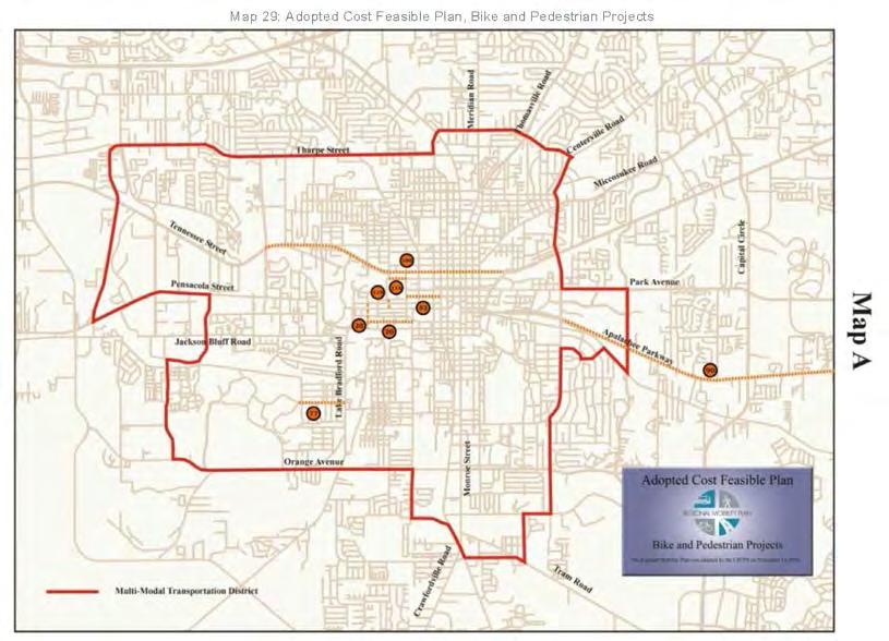
169 Text Amendment PCT201802


170
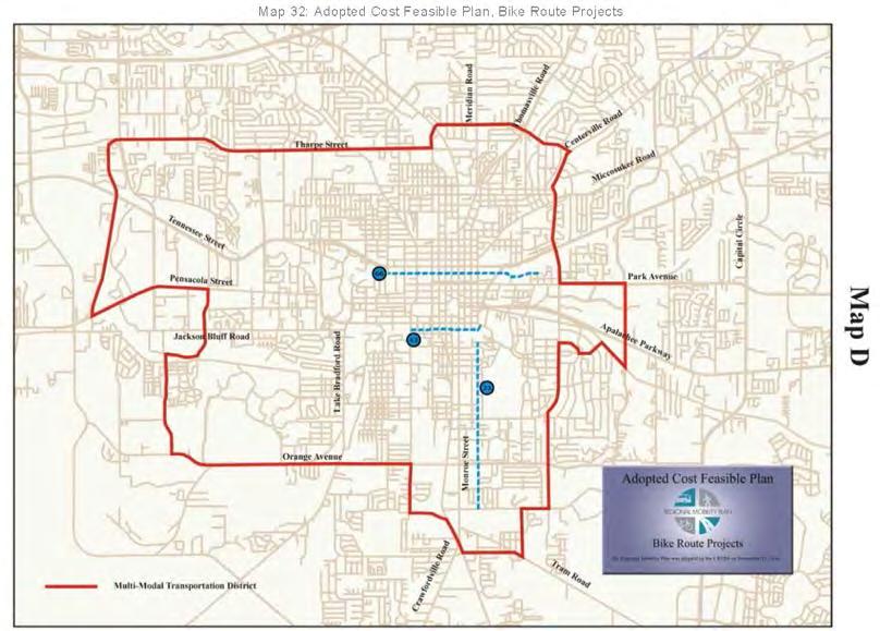

171
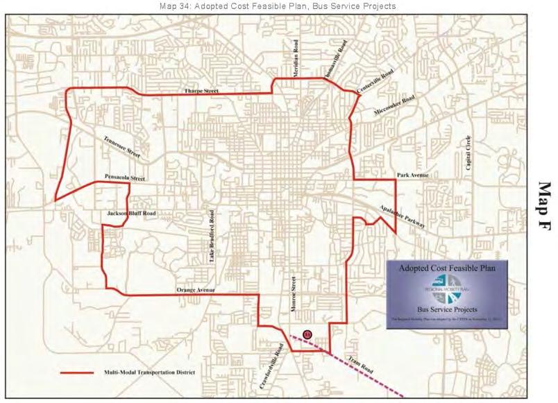
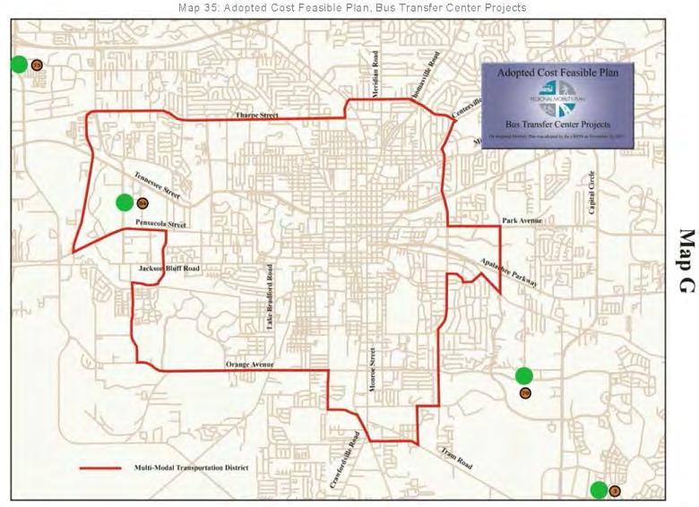
172


173
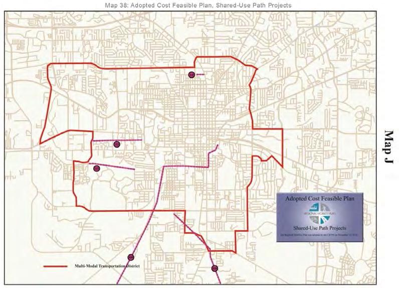

174
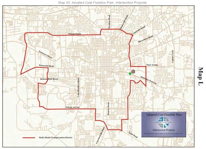
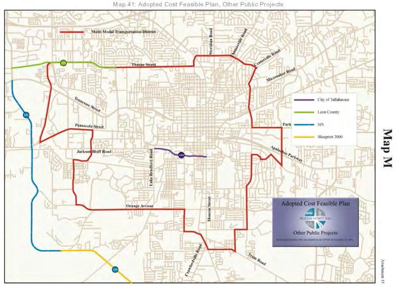
175

176 Map 28: Adopted Cost Feasible Plan, CRTPA Regional Mobility Plan
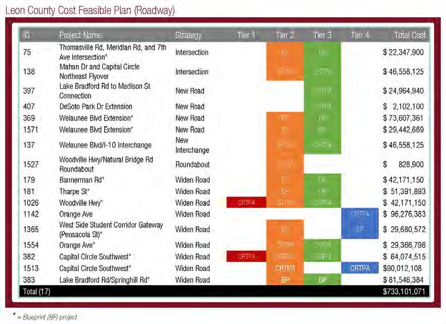
177
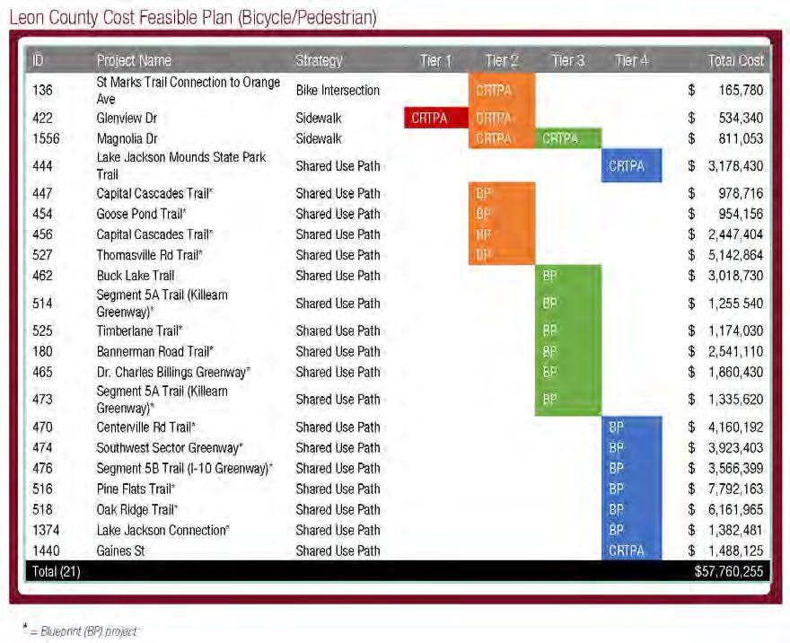
178
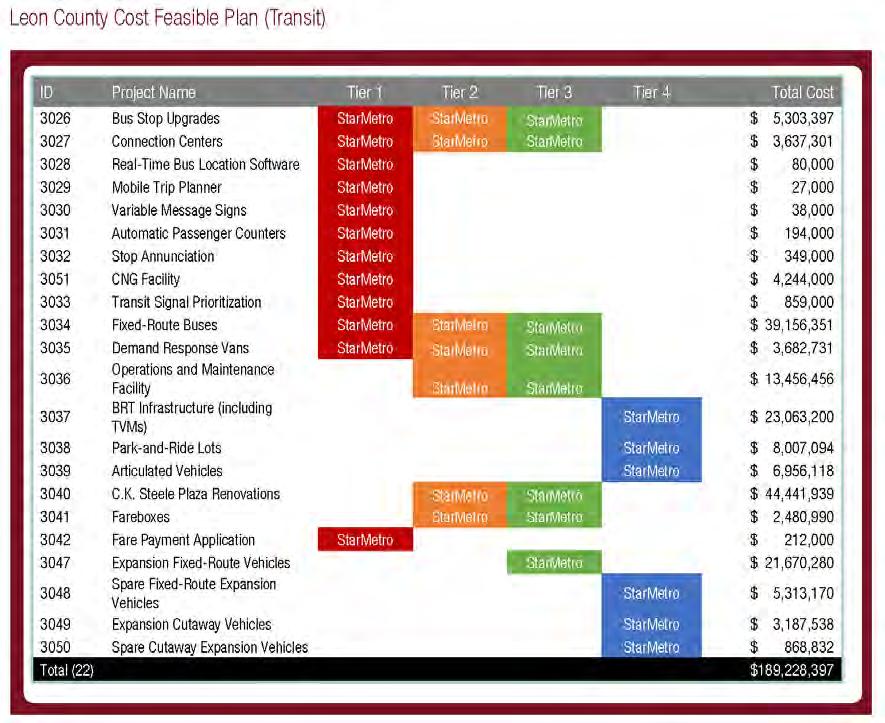
179
180
181
182
183
184
185
186
187
188
189
190
191
192
193
194
195
196
197
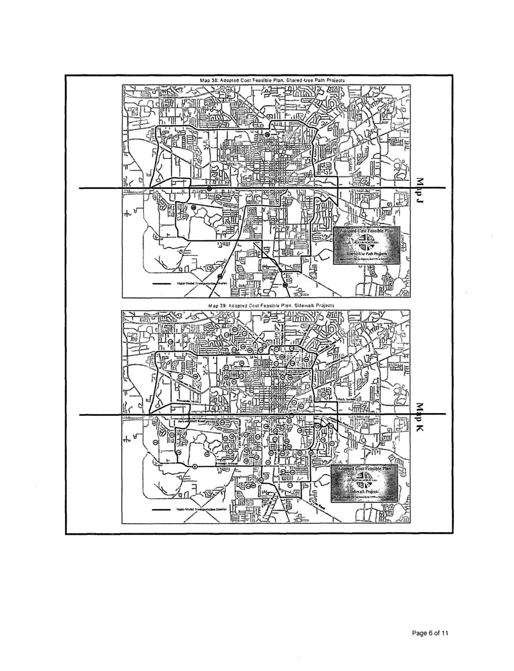
198
199
200
201
202
203
204
205
206
207
208
209
210
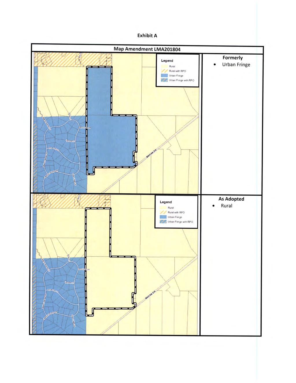
211
212

213
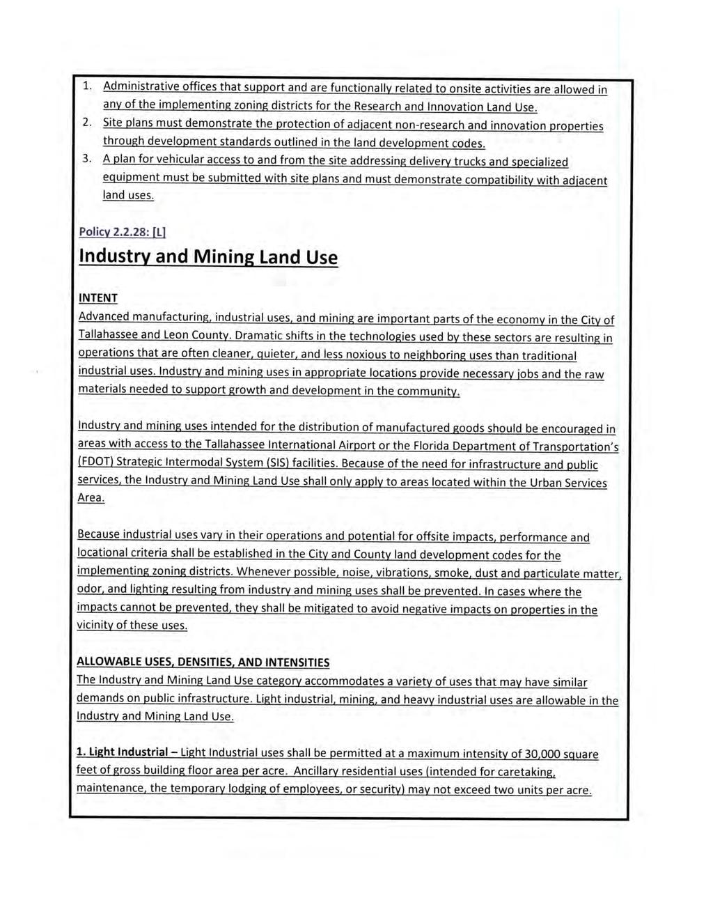
214

215

216
217
218

219
220
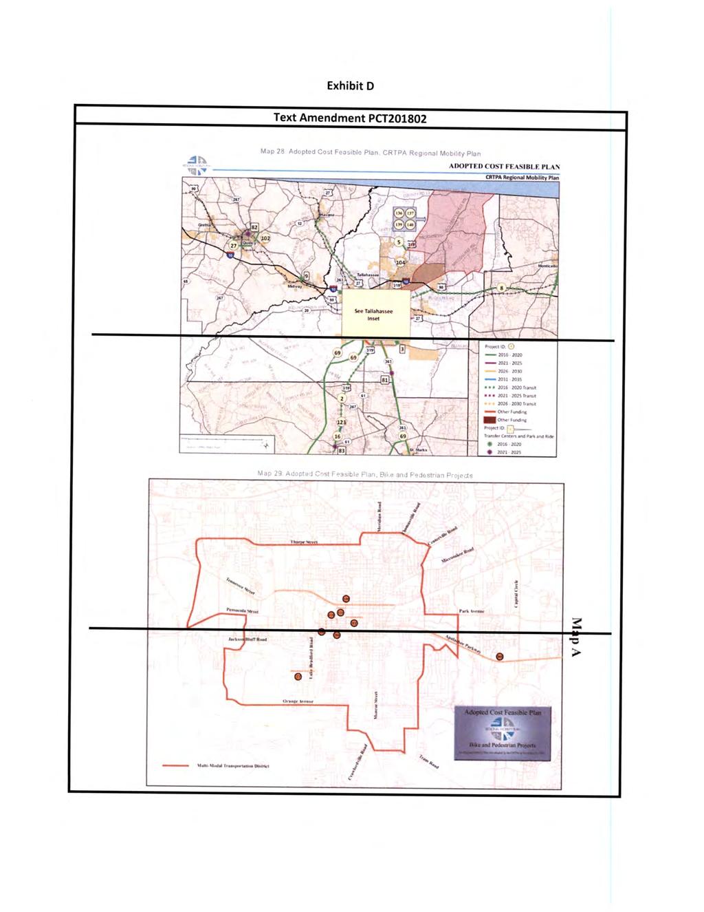
221
222
223
224
225
226
227
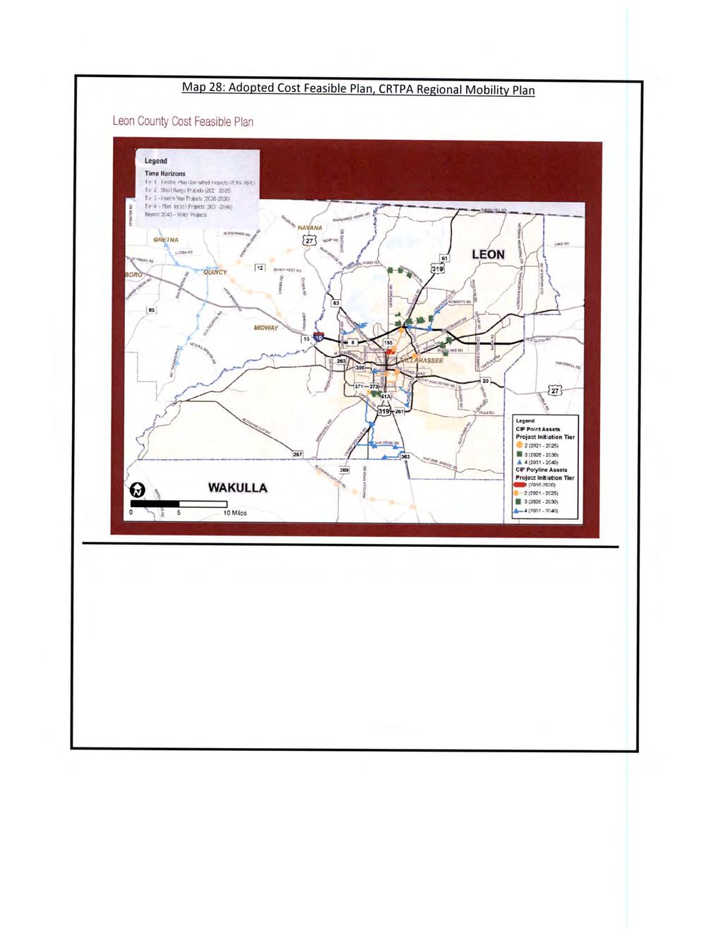
228
229
230
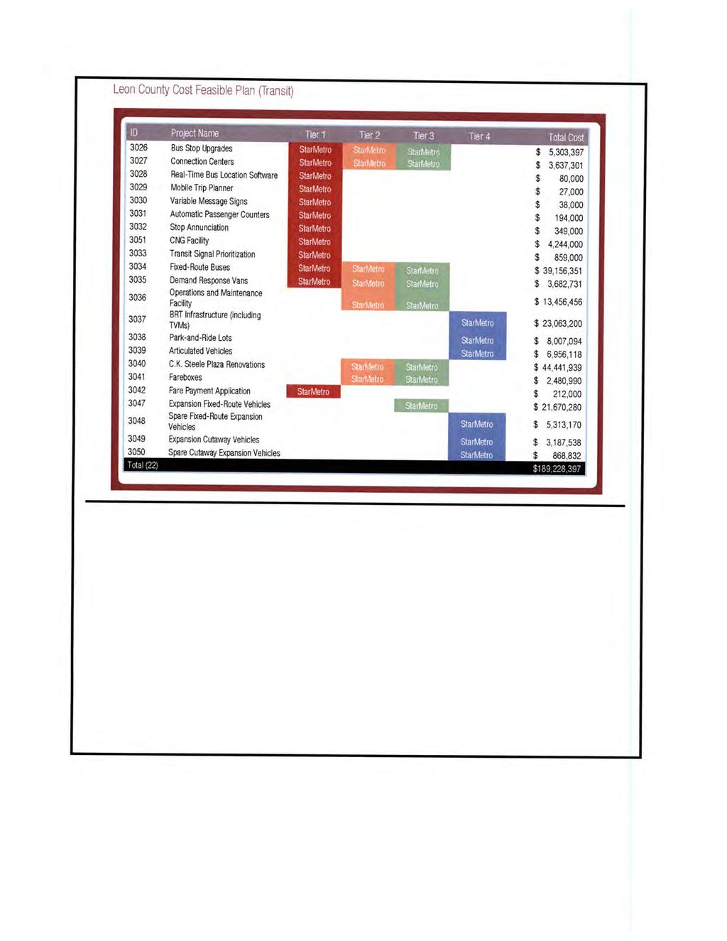
231
232 June 28, 2018 Mr. Ray Eubanks Plan Processing Administrator State Land Planning Agency - Department of Economic Opportunity Caldwell Building 107 East Madison - MSC 160 Tallahassee, Florida Re: Adopted Comprehensive Plan Amendments Package (18-2ESR) Dear Mr. Eubanks: The Tallahassee-Leon County Planning Department hereby submits an adopted text amendment for the 2018 Comprehensive Plan Amendment Cycle for the City of Tallahassee and Leon County, amending the Joint Tallahassee-Leon County 2030 Comprehensive Plan. These amendments are submitted pursuant to the Joint City-County Commission adoption public hearing on June 21, As transmitted to the State Land Planning Agency and review agencies, the adopted amendments package includes one text amendment. The Tallahassee City Commission and Leon County Board of County Commissioners adopted the Comprehensive Plan amendments as modified based on a technical assistance comment provided by the Department of Economic Opportunity. Enclosed are the following ordinances adopting the comprehensive plan amendment: City of Tallahassee Ordinance 18-O-20 adopted June 21, 2018 Leon County Ordinance No adopted June 21, 2018 The appropriate review agencies are copied on this letter and provided with a complete adopted amendments package in Portable Document Format (PDF). If you have any questions concerning the proposed amendments, please contact Artie White at (850) ; 300 South Adams Street, Tallahassee, FL 32301; FAX: (850) ; artie.white@talgov.com Sincerely, Cherie Bryant, AICP Planning Manager Tallahassee-Leon County Planning Department City Hall 300 South Adams Street Tallahassee, Florida (850)
233 cc: Department of Agriculture and Consumer Services (w/attachments) Department of Education (w/attachments) Department of Environmental Protection (w/attachments) Department of State (w/attachments) Florida Fish and Wildlife Conservation Commission (w/attachments) Department of Transportation, District Three (w/attachments) Apalachee Regional Planning Council (w/attachments) Northwest Florida Water Management District (w/attachments) Jessica Icerman (w/o attachments) Lou Norvell (w/o attachments) City Hall 300 South Adams Street Tallahassee, Florida (850)
234 Item # Amendment To: Nature of Proposed Amendment PCM PCM PCM PCM LMA LMA LMA PCT PCT PCT FUTURE LAND USE MAP Parkway Place FUTURE LAND USE MAP PetroSouth FUTURE LAND USE MAP FSU Health Clinic FUTURE LAND USE MAP Chabad House FUTURE LAND USE MAP Capital Circle Light Industrial FUTURE LAND USE MAP East Mahan FUTURE LAND USE MAP Barcelona Offices LAND USE ELEMENT Science & Innovation and Industry & Mining Land Uses MOBILITY ELEMENT Regional Mobility Plan Maps INTERGOVERNMENTAL COORDINATION ELEMENT Comprehensive Plan Amendment Process From: Residential Preservation To: Suburban 0.41 acres From: Urban Residential-2 To: Suburban 0.6 acres From: Educational Facilities and Recreation/Open Space To: Government Operational 1.79 acres From: Residential Preservation To: University Transition 3.71 acres From: Urban Fringe To: Suburban 3.8 acres From: Urban Fringe To: Rural 232 acres From: Urban Residential-2 To: Suburban 30 acres New land use categories that address research and development and innovation districts, and industrial, light industrial, and mining uses. Update the Adopted Cost Feasible Map and replace the project specific Adopted Cost Feasible Maps with project lists. Update Objective 1.8 and Policy addressing the Comprehensive Plan Amendment Process. MATRIX FOR 2018 CYCLE AMENDMENTS Planning Staff Recommendation LPA Recommendation A A A A A A A A AM (Approve with Expansion Area) AM (Approve with Expansion Area) AM (Approve with Expansion Area) AM (Approve with Expansion Area) A = Approve D = Denial AM = Approve as Modified Board/Commission Position A AM (Approve with Expansion Area) AM (Approve with Expansion Area) A A A A A A A A A A A A A A A Status Small Scale Map Amendment Adopted February 27, 2018 Small Scale Map Amendment Adopted February 27, 2018 Small Scale Map Amendment Adopted February 27, 2018 Large Scale Map Amendment Transmitted February 27, 2018 Adopted April 10, 2018 Small Scale Map Amendment Adopted February 27, 2018 Large Scale Map Amendment Transmitted February 27, 2018 Adopted April 10, 2018 Large Scale Map Amendment Transmitted February 27, 2018 Adopted April 10, 2018 Text Amendment Transmitted February 27, 2018 Adopted April 10, 2018 Text Amendment Transmitted February 27, 2018 Adopted April 10, 2018 Text Amendment Transmitted April 10, 2018 Adopted June 21, 2018
235 Adopted Map and Text Amendments: See attached. Adoption Amendment Package 18-2ESR A copy of any data and analyses the local government deems appropriate: No additional data and analysis. The local government is relying on previously submitted data and analysis. Copies of executed ordinances: See attached. List of additional changes made in the adopted amendment that the Department of Economic Opportunity did not previously review: The proposed amendment was modified based on a technical assistance comment from the Department of Economic Opportunity. See the attached adopted Map and Text Amendments showing the modification. List of findings of the local governing body, if any, that were not included in the ordinance and which provided the basis of the adoption or determination not to adopt the proposed amendment: None. Statement indicating the relationship of the additional changes not previously reviewed by the Department of Economic Opportunity in response to the comment letter from the Department of Economic Opportunity: The proposed amendment was modified based on a technical assistance comment from the Department of Economic Opportunity. See the attached adopted Map and Text Amendments showing the modification.
236 2018 Comprehensive Plan Amendment Cycle PCT Intergovernmental Coordination Element Adopted Amendment Modifications based on the technical assistance comment from DEO are shown in red. Objective 1.8: [I] Develop Provide a joint comprehensive plan amendment procedure that is consistent with state statute. Policy 1.8.1: [I] The Comprehensive Plan may be amended no more than twice a year at a joint City-County Commission meeting. To promote the efficient use of City and County resources, one Comprehensive Plan amendment cycle will be initiated annually. The Board of County Commissioners or City Commission may approve the initiation of additional Comprehensive Plan amendments outside of the annual cycle. Amendments to the Joint Comprehensive Plan shall be effective only upon require approval by both the Leon County Board of County Commissioners and the Tallahassee City Commission except as set forth below: (1) An amendment to the Future Land Use Map which concerns property located entirely within the Tallahassee city limits, or an amendment to an existing provision of the Comprehensive Plan which is designated as specific to the City of Tallahassee, shall be effective upon require approval solely by the Tallahassee City Commission. (2) An amendment to the Future Land Use Map which concerns property located entirely within unincorporated Leon County, or an amendment to an existing provision of the Comprehensive Plan which is designated as specific to Leon County, shall be effective upon require approval solely by the Leon County Board of County Commissioners. All amendments to the Joint Comprehensive Plan shall follow the statutory process for the adoption of plan amendments with effective dates as outlined in Florida Statutes.
237
238
239
240
241

242
2018 Comprehensive Plan Amendment Cycle PCM Chapel Drive Amendment
 2018 Comprehensive Plan Amendment Cycle PCM201804 Chapel Drive Amendment Property Owners: Rabbi Schneur Z. Oirechman Applicant: Urban Catalyst Consultants, Inc. 2851 Remington Green Circle, Ste. D. TLCPD
INDIAN RIVER COUNTY, FLORIDA. The Honorable Members of the Planning and Zoning Commission DEPARTMENT HEAD CONCURRENCE
 Public Hearing Legislative INDIAN RIVER COUNTY, FLORIDA M E M O R A N D U M TO: The Honorable Members of the Planning and Zoning Commission DEPARTMENT HEAD CONCURRENCE Robert M. Keating, AICP; Community
ARTICLE 3: Zone Districts
 ARTICLE 3: Zone Districts... 3-1 17.3.1: General...3-1 17.3.1.1: Purpose and Intent... 3-1 17.3.2: Districts and Maps...3-1 17.3.2.1: Applicability... 3-1 17.3.2.2: Creation of Districts... 3-1 17.3.2.3:
General Index. General Index
 General Index A aesthetics... iv, v, 1, 4, 8, 45, 91, 105, 146, 181, 293, 302 agreements developer s binding... 169, 176, 209, 262, 267, 272, 281, 282, 293 interlocal...164, 165, 249 water and sewer...
Appendix A: Guide to Zoning Categories Prince George's County, Maryland
 Appendix A: Guide to Zoning Categories Prince George's County, Maryland RESIDENTIAL ZONES 1 Updated November 2010 R-O-S: Reserved Open Space - Provides for permanent maintenance of certain areas of land
TREASURE COAST REGIONAL PLANNING COUNCIL M E M O R A N D U M
 TREASURE COAST REGIONAL PLANNING COUNCIL M E M O R A N D U M To: Council Members AGENDA ITEM 5F From: Date: Subject: Staff July 16, 2010 Council Meeting Local Government Comprehensive Plan Review Draft
PLANNED UNIT DEVELOPMENT & SUBDIVISION STAFF REPORT Date: April 18, 2019
 PLANNED UNIT DEVELOPMENT & SUBDIVISION STAFF REPORT Date: April 18, 2019 DEVELOPMENT NAME SUBDIVISION NAME Springhill Village Subdivision Springhill Village Subdivision LOCATION 4350, 4354, 4356, 4358,
Glades County Staff Report and Recommendation REZONING
 Glades County Staff Report and Recommendation REZONING CASE NUMBER: RZ15-01 DATE: October 2, 2015 CASE TYPE: Application for Rezoning REQUEST: J.J. Wiggins Memorial Trust is requesting a rezoning of 22.1±
FUTURE LAND USE. City of St. Augustine Comprehensive Plan EAR-Based Amendments
 FUTURE LAND USE City of St. Augustine Comprehensive Plan EAR-Based Amendments Future Land Use Element FLU Goal To create an environment within the City and adjacent areas in which its residents have the
REPORT OF THE PLANNING AND DEVELOPMENT DEPARTMENT FOR APPLICATION FOR REZONING ORDINANCE TO PLANNED UNIT DEVELOPMENT SEPTEMBER 22, 2016
 BEL REPORT OF THE PLANNING AND DEVELOPMENT DEPARTMENT FOR APPLICATION FOR REZONING ORDINANCE 2016-576 TO PLANNED UNIT DEVELOPMENT SEPTEMBER 22, 2016 The Planning and Development Department hereby forwards
TOTTENHAM SECONDARY PLAN
 TOTTENHAM SECONDARY PLAN AMENDMENT NO. 11 TO THE OFFICIAL PLAN OF THE TOWN OF NEW TECUMSETH The following text and schedules to the Official Plan of the Town of New Tecumseth constitute Amendment No. 11
Nassau County Department of Planning & Economic Opportunity Nassau Place Yulee, Florida 32097
 Nassau County Department of Planning & Economic Opportunity 96161 Nassau Place Yulee, Florida 32097 APPLICATION AND INSTRUCTIONS FOR FUTURE LAND USE MAP AMENDMENT (TEN (10) ACRES OR MORE) NOTICE: Florida
REZONING GUIDE. Zone Map Amendment (Rezoning) - Application. Rezoning Application Page 1 of 3. Return completed form to
 - Application. Rezoning Application Page 1 of 3. Return completed form to") COMMUNITY PLANNING & DEVELOPMENT REZONING GUIDE Rezoning Application Page 1 of 3 Zone Map Amendment (Rezoning) - Application PROPERTY OWNER INFORMATION* PROPERTY OWNER(S) REPRESENTATIVE** CHECK IF POINT
COMMUNITY PLANNING & DEVELOPMENT REZONING GUIDE Rezoning Application Page 1 of 3 Zone Map Amendment (Rezoning) - Application PROPERTY OWNER INFORMATION* PROPERTY OWNER(S) REPRESENTATIVE** CHECK IF POINT
REPORT OF THE PLANNING AND DEVELOPMENT DEPARTMENT FOR APPLICATION FOR REZONING ORDINANCE TO PLANNED UNIT DEVELOPMENT APRIL 21, 2016
 BEL REPORT OF THE PLANNING AND DEVELOPMENT DEPARTMENT FOR APPLICATION FOR REZONING ORDINANCE TO PLANNED UNIT DEVELOPMENT APRIL 21, 2016 The Planning and Development Department hereby forwards to the Planning
PLANNING COMMISSION STAFF REPORT
 PLANNING COMMISSION STAFF REPORT REZONING CASE: RZ-16-001 REPORT DATE: March 8, 2016 CASE NAME: Trailbreak Partners Rezoning PLANNING COMMISSION DATE: March 16, 2016 ADDRESSES OF REZONING PROPOSAL: 5501
Glades County Staff Report and Recommendation Unified Staff Report for Small Scale Plan Amendment and Rezoning
 Glades County Staff Report and Recommendation Unified Staff Report for Small Scale Plan Amendment and Rezoning CASE NUMBERS: COMP17-02 and RZ17-02 DATE of STAFF REPORT: May 1, 2017 CASE TYPE: Application
Salem HNA and EOA Advisory Committee Meeting #6
 Salem HNA and EOA Advisory Committee Meeting #6 Residential Land Policies Employment Land Policies Policy Discussions with the Committee Outcome of today s meeting Direction from this Committee on proposed
Planning Justification Report
 Planning Justification Report 101 Kozlov Street, Barrie, Ont. Destaron Property Management Ltd. November 2015 Revised February 2017 TABLE OF CONTENTS Page 1.0 INTRODUCTION... 1 2.0 DESCRIPTION OF SUBJECT
PC Staff Report 11/18/2013 Z Item No. 1-1
 Z-13-00401 Item No. 1-1 PLANNING COMMISSION REPORT Regular Agenda - Public Hearing Item PC Staff Report 11/18/2013 ITEM NO. 1: Z-13-00401 IG (General Industrial) District TO CS (Strip Commercial) District;
Marion County Board of County Commissioners
 Marion County Board of County Commissioners Date: 12/29/2015 P&Z: 12/28/2015 BCC: 1/12/2016 Item Number 160113Z Type of Application Rezoning Request From: A-1 (General Agriculture) To: PUD (Planned Unit
INFORMATION PACKET City of Tallahassee Application for PUD or UPUD Rezoning Review
 Comprehensive Plan Consistency Prerequisite INFORMATION PACKET City of Tallahassee Application for PUD or UPUD Rezoning Review Any and all amendments to the Official Zoning Map (rezoning) are required
GENERAL PLAN UPDATE SPECIFIC AREAS OF THE CITY
 GENERAL PLAN UPDATE SPECIFIC AREAS OF THE CITY Background There are a total of 14 specific areas that are being reviewed as part of the update of the General Plan. Requests to review these areas came from
ARTICLE 14 PLANNED UNIT DEVELOPMENT (PUD) DISTRICT
 DISTRICT") ARTICLE 14 PLANNED UNIT DEVELOPMENT (PUD) DISTRICT Section 14.01 Intent. It is the intent of this Article to allow the use of the planned unit development (PUD) process, as authorized by the Michigan Zoning
ARTICLE 14 PLANNED UNIT DEVELOPMENT (PUD) DISTRICT Section 14.01 Intent. It is the intent of this Article to allow the use of the planned unit development (PUD) process, as authorized by the Michigan Zoning
TREASURE COAST REGIONAL PLANNING COUNCIL M E M O R A N D U M
 TREASURE COAST REGIONAL PLANNING COUNCIL M E M O R A N D U M To: Council Members AGENDA ITEM 6A From: Date: Subject: Staff May 20, 2011 Council Meeting Local Government Comprehensive Plan Review Draft
PINELLAS COUNTY COMPREHENSIVE PLAN
 PINELLAS COUNTY COMPREHENSIVE PLAN Future Land Use Map (FLUM) Category Descriptions and Rules Amended March 17, 2009 (Ordinance 09-17) Amended March 16, 2010 (Ordinance 10-18) Amended October 26, 2010
REPORT OF THE PLANNING AND DEVELOPMENT DEPARTMENT FOR APPLICATION FOR REZONING ORDINANCE TO PLANNED UNIT DEVELOPMENT MAY 8, 2014
 BEL REPORT OF THE PLANNING AND DEVELOPMENT DEPARTMENT FOR APPLICATION FOR REZONING ORDINANCE TO PLANNED UNIT DEVELOPMENT MAY 8, 2014 The Planning and Development Department hereby forwards to the Planning
TALLAHASSEE-LEON COUNTY 2030 COMPREHENSIVE PLAN
 TALLAHASSEE-LEON COUNTY 2030 COMPREHENSIVE PLAN The Tallahassee-Leon County Comprehensive Plan was adopted on July 16, 1990. The plan horizon for the Tallahassee-Leon County Comprehensive Plan is 2030.
PLANNING COMMISSION STAFF REPORT
 PLANNING COMMISSION STAFF REPORT REZONING CASE: RZ-15-002 REPORT DATE: January 26, 2016 CASE NAME: Thursday Lunch Club Rezoning PLANNING COMMISSION DATE: February 17, 2016 ADDRESS OF REZONING PROPOSAL:
Midwest City, Oklahoma Zoning Ordinance
 2010 Midwest City, Oklahoma Zoning Ordinance 9/2/2010 Table of Contents Section 1. General Provisions... 5 1.1. Citation... 5 1.2. Authority... 5 1.3. Purpose... 5 1.4. Nature and Application... 5 1.5.
REZONING APPLICATION INSTRUCTIONS
 REZONING APPLICATION INSTRUCTIONS All required information, as stated on the Rezoning Application Checklist, must be included to qualify as a complete application. Upon receipt, staff will review the application
GENERAL DESCRIPTION STAFF RECOMMENDATION IMPLEMENTATION REQUIREMENTS
 Application No.: 891418 Applicant: AREA-WIDE MAP AMENDMENT Rezone two parcels from Moderate Density Single Family (MSF) to Neighborhood Center (NC) and Employment Center (EC). Charles Bitton GENERAL DESCRIPTION
RP-2, RP-3, RP-4, AND RP-5 PLANNED RESIDENTIAL DISTRICTS
 6.10 - RP-2, RP-3, RP-4, AND RP-5 PLANNED RESIDENTIAL DISTRICTS 6.10.1 GENERAL DESCRIPTION: 6.10.1.1 The regulations established in this Section are intended to provide optional methods of land development
PLANNING COMMISSION REPORT Regular Agenda - Public Hearing Item
 Z-11-25-09; Z-11-26-09; Z-11-28-09 Item No. 2-1 PC Staff Report 3/28/11 PLANNING COMMISSION REPORT Regular Agenda - Public Hearing Item ITEM NO. 2A RM32 TO MU;.19 ACRES; 1340 TENNESSEE ST (MJL) Z-1-1-11:
8/17/16 PC Meeting 1
 1 GENERAL INFORMATION OWNER/APPLICANT: Thomas Corff & Terry Moberly (1943 13 th St.) 19328 Towercrest Dr. Oregon City, OR 97045 Michael & Jill Parker (1983 13 th St.) 1708 Oak St. Lake Oswego, OR 97034
Land Use, Transportation, and Infrastructure Committee of Denver City Council FROM: Scott Robinson, Senior City Planner DATE: December 6, 2018 RE:
 Community Planning and Development Planning Services 201 W. Colfax Ave., Dept. 205 Denver, CO 80202 p: 720.865.2915 f: 720.865.3052 www.denvergov.org/cpd TO: Land Use, Transportation, and Infrastructure
Comprehensive Plan Amendment #PLN , Reserve at Cannon Branch (Coles Magisterial District)
") COUNTY OF PRINCE WILLIAM 5 County Complex Court, Prince William, Virginia 22192-9201 PLANNING (703) 792-7615 FAX (703) 792-4758 OFFICE Internet www.pwcgov.org Christopher M. Price, AICP Director of Planning
COUNTY OF PRINCE WILLIAM 5 County Complex Court, Prince William, Virginia 22192-9201 PLANNING (703) 792-7615 FAX (703) 792-4758 OFFICE Internet www.pwcgov.org Christopher M. Price, AICP Director of Planning
13 Sectional Map Amendment
 13 Sectional Map Amendment Introduction This chapter reviews land use and zoning policies and practices in Prince George s County and presents the proposed zoning in the sectional map amendment (SMA) to
Place Type Descriptions Vision 2037 Comprehensive Plan
 Place Type Descriptions Vision 2037 Comprehensive Plan The Vision 2037 Comprehensive Plan establishes a range of place types for Oxford, ranging from low intensity (limited development) Rural and Natural
Leon County APPLICATION FOR PUD REZONING REVIEW
 APPLICATION FOR PUD REZONING REVIEW The undersigned, owner of the hereinafter-described property, hereby petitions Leon County for the following amendment to the Official Zoning Map: Change in Zoning District
TREASURE COAST REGIONAL PLANNING COUNCIL M E M O R A N D U M. To: Council Members AGENDA ITEM 10A
 TREASURE COAST REGIONAL PLANNING COUNCIL M E M O R A N D U M To: Council Members AGENDA ITEM 10A From: Date: Subject: Staff April 20, 2007 Council Meeting Local Government Comprehensive Plan Review Draft
Primary Districts Established 4
 4.1 GENERAL PURPOSE SECTION 4 PRIMARY DISTRICTS ESTABLISHED The Town of Waxhaw, North Carolina is hereby divided into PRIMARY ZONING DISTRICTS as designated herein and as shown on the Official Zoning Map.
PLANNING COMMISSION STAFF REPORT
 PLANNING COMMISSION STAFF REPORT West Capitol Hill Zoning Map Amendment Petition No. PLNPCM2011-00665 Located approximately at 548 W 300 North Street, 543 W 400 North Street, and 375 N 500 West Street
Planning Department Oconee County, Georgia
 Planning Department Oconee County, Georgia STAFF REPORT REZONE CASE #: 6985 DATE: October 31, 2016 STAFF REPORT BY: Andrew C. Stern, Planner APPLICANT NAME: Williams & Associates, Land Planners PC PROPERTY
Bylaw No , being "Official Community Plan Bylaw, 2016" Schedule "A" DRAFT
 Bylaw No. 2600-2016, being "Official Community Plan Bylaw, 2016" Schedule "A" Urban Structure + Growth Plan Urban Structure Land use and growth management are among the most powerful policy tools at the
Land Use Planning Analysis. Phase 2 Drayton Valley Annexation Proposal
 Land Use Planning Analysis Phase 2 Drayton Valley Annexation Proposal Prepared for Town of Drayton Valley Prepared by Mackenzie Associates Consulting Group Limited March, 2011 TABLE OF CONTENTS 1.0 INTRODUCTION...
POLK COUNTY DEVELOPMENT REVIEW COMMITTEE CASE OVERVIEW
 POLK COUNTY DEVELOPMENT REVIEW COMMITTEE CASE OVERVIEW DRC Date: January 10, 2019 Level of Review: 4 PC Date: March 6, 2019 Type: Text Amendments BoCC Date: May 7, 2019 July 2, 2019 Case Numbers: Case
STAFF REPORT City of Ormond Beach Department of Planning
 STAFF REPORT City of Ormond Beach Department of Planning DATE: February 5, 2014 SUBJECT: 875 Sterthaus Drive, Ormond Renaissance Condominium, Comprehensive Plan Amendment over ten acres APPLICANT: Parker
REPORT OF THE PLANNING AND DEVELOPMENT DEPARTMENT FOR APPLICATION FOR REZONING ORDINANCE TO PLANNED UNIT DEVELOPMENT MAY 18, 2017
 BEL REPORT OF THE PLANNING AND DEVELOPMENT DEPARTMENT FOR APPLICATION FOR REZONING ORDINANCE 2016-805 TO PLANNED UNIT DEVELOPMENT MAY 18, 2017 The Planning and Development Department hereby forwards to
Cover Letter with Narrative Statement
 Cover Letter with Narrative Statement March 31, 2017 rev July 27, 2017 RE: Rushton Pointe Residential Planned Unit Development Application for Public Hearing for RPUD Rezone PL2015 000 0306 Mr. Eric Johnson,
1. Future Land Use FLU6.6.8 Land uses within the Rural Service Area portion of the Wekiva Study Area shall be limited to very low and low intensity
 1. Future Land Use FLU6.6.8 Land uses within the Rural Service Area portion of the Wekiva Study Area shall be limited to very low and low intensity uses to the greatest extent possible. Existing land uses
CITY OF FARMERSVILLE CITIZEN ADVISORY COMMITTEE AGENDA November 17, :30 P.M. 1, COUNCIL CHAMBERS, CITY HALL
 I. PRELIMINARY MATTERS CITY OF FARMERSVILLE CITIZEN ADVISORY COMMITTEE AGENDA November 17, 2014 6:30 P.M. 1, COUNCIL CHAMBERS, CITY HALL Call to Order, Roll Call, Prayer and Pledge of Allegiance Welcome
City of Valdosta Land Development Regulations
 Chapter 206 Section 206-1 Base Zoning Districts Standards for Uses, Structures, and Property Development (B) (C) Principal Uses and Structures. Principal uses and structures permitted in each base zoning
Metropolitan Planning Commission. DATE: April 5, 2016
 TO: FROM: Metropolitan Planning Commission MPC Staff DATE: April 5, 2016 SUBJECT: Petition of Nine Line Inc. Robert McCorkle, Agent PIN: 2-1034-01-002 380.5 Acres Aldermanic District: 5 (Shabazz) County
COMPREHENSIVE PLAN FUTURE LAND USE MAP AMENDMENT APPLICATION
 COUNTY STAFF DATA ONLY Date Received: Project No. CPA-20 - GADSDEN COUNTY DEPARTMENT OF PLANNING & COMMUNITY DEVELOPMENT 1-B East Jefferson Street, Post Office Box 1799, Quincy, FL 32353-1799 PLANNING
Request. Recommendation. Recommended Motion. Planning Division Department of Community and Economic Development
 PLANNING COMMISSION STAFF REPORT Legislative Item 900 South 900 East Rezone Zoning Map Amendment PLNPCM2010-00360 700 East 900 East, 700 South 900 South December 12, 2012 Applicant: City Council Luke Garrott
TREASURE COAST REGIONAL PLANNING COUNCIL M E M O R A N D U M. To: Regional Planning Council Members AGENDA ITEM 5D
 TREASURE COAST REGIONAL PLANNING COUNCIL M E M O R A N D U M To: Regional Planning Council Members AGENDA ITEM 5D From: Date: Subject: Staff March 20, 2009 Regional Planning Council Meeting Local Government
HOUSING ELEMENT GOALS, OBJECTIVES, AND POLICIES
 HOUSING ELEMENT GOALS, OBJECTIVES, AND POLICIES GOAL 1: To promote the preservation and development of high-quality, balanced, and diverse housing options for persons of all income levels throughout the
Board of County Commissioners Agenda Request
 Board of County Commissioners Agenda Request Date of Meeting: March 26, 2019 Date Submitted: March 19, 2019 To: From: Agenda Location: Subject: Honorable Chairman and Members of the Board Margaret Emblidge,
AGENDA ITEM SUMMARY GLADES COUNTY BOARD OF COUNTY COMMISSIONERS
 AGENDA ITEM SUMMARY GLADES COUNTY BOARD OF COUNTY COMMISSIONERS SUBJECT: Case Number COMP17-01, Legend Moto LLC This is a Legislative Hearing. DEPARTMENT REQUEST: The Community Development Department requests
STAFF REPORT. Permit Number: Laurier Enterprises, Inc. Kitsap County Board of Commissioners; Kitsap County Planning Commission
 STAFF REPORT Permit Number: 15 00740 Laurier Enterprises, Inc. DATE: December 18, 2015 TO: FROM: Kitsap County Board of Commissioners; Kitsap County Planning Commission Katrina Knutson, AICP, Senior Planner,
CASE # LUP Commission District: # 3
 CASE # LUP-15-02-038 Commission District: # 3 GENERAL INFORMATION APPLICANT OWNER PROJECT NAME HEARING TYPE REQUEST Richard Frucci Lingo Lane, LLC Lingo Lane Planned Development / Land Use Plan (PD/LUP)
Rural Living (RL) Rural Living
 Rural Living") Place Types Rural Living (RL) Rural Living Rural living areas are characterized by very large lots, abundant open space, pastoral views, and a highdegree of separation between buildings. The lots are typically
Place Types Rural Living (RL) Rural Living Rural living areas are characterized by very large lots, abundant open space, pastoral views, and a highdegree of separation between buildings. The lots are typically
Rule 80. Preservation of Primary Agricultural Soils Revised and approved by the Land Use Panel during its public meeting on January 31, 2006.
 Rule 80. Preservation of Primary Agricultural Soils Revised and approved by the Land Use Panel during its public meeting on January 31, 2006. (A) Purpose. In accordance with 10 V.S.A. Sections 6025(b)
Housing & Residential Intensification Study Discussion Paper Township of King
 Housing & Residential Intensification Study Discussion Paper Prepared by Planning Department January 2011 1.0 Background 1.1 Provincial Policies (Greenbelt and Growth Plan) Since 2001, the Province of
1 Chapter 4 FUTURE LAND USE ELEMENT Section 4.1. Background information. 4.1.A. Land use profile. Indiantown possesses a unique and valuable mix of ph
 1 Chapter 4 FUTURE LAND USE ELEMENT Section 4.1. Background information. 4.1.A. Land use profile. Indiantown possesses a unique and valuable mix of physical and man-made resources centered on the Okeechobee
STAFF REPORT. Community Development Director PO Box 4755 Beaverton, OR 97076
 STAFF REPORT HEARING DATE: July 7, 2010 TO: Planning Commission STAFF: Jana Fox, Assistant Planner PROPOSAL: Southeast Beaverton Office Commercial Zoning Map Amendment (ZMA2010-0006) LOCATION: The subject
Pierce County Comprehensive Plan Review
 2015-2016 Pierce County Comprehensive Plan Review March 16, 2016 Introduction Planning and Management Policies Some of the policies governing both the planning and management of growth and change within
3.1. OBJECTIVES FOR RESIDENTIAL LAND USE DESIGNATIONS GENERAL OBJECTIVES FOR ALL RESIDENTIAL DESIGNATIONS
 3. RESIDENTIAL LAND USE DESIGNATIONS INTRODUCTION The Residential land use designations provide for housing and other land uses that are integral to, and supportive of, a residential environment. Housing
Article 7: Residential Land Use and Development Requirements
 Article 7: Residential Land Use and Section 701: Statement of Intent (A) (B) (C) The intent of Article 7 is to develop certain land use and development requirements for the residential uses within Cumru
Mohave County General Plan
 63 64 65 66 67 68 69 70 71 The Land Use Diagram is not the County's zoning map. 13 It is a guide to future land use patterns. Zoning and area plan designations may be more restrictive than the land use
HENDRY COUNTY PLANNING & ZONING DEPARTMENT POST OFFICE BOX S. MAIN STREET LABELLE, FLORIDA (863) FAX: (863)
 FAX: (863)") HENDRY COUNTY PLANNING & ZONING DEPARTMENT POST OFFICE BOX 2340 640 S. MAIN STREET LABELLE, FLORIDA 33975 (863) 675-5240 FAX: (863) 674-4194 STAFF REPORT CPA19-0001 Comprehensive Plan Map Amendment Local
HENDRY COUNTY PLANNING & ZONING DEPARTMENT POST OFFICE BOX 2340 640 S. MAIN STREET LABELLE, FLORIDA 33975 (863) 675-5240 FAX: (863) 674-4194 STAFF REPORT CPA19-0001 Comprehensive Plan Map Amendment Local
GEORGE / GROSVENOR AREA STUDY RECOMMENDATIONS PLANNING CITY OF LONDON DEPARTMENT OF. MAY 1985 r----q
 GEORGE / GROSVENOR AREA STUDY RECOMMENDATIONS CITY OF LONDON DEPARTMENT OF PLANNING MAY 1985 r----q PREFACE On April 9, 1985, the Planning Committee held a public meeting regarding the St. George/Grosvenor
STAFF SUMMARY OF Z17-10 CONDITIONAL ZONING DISTRICT APPLICATION
 STAFF SUMMARY OF Z17-10 CONDITIONAL ZONING DISTRICT APPLICATION APPLICATION SUMMARY Case Number: Z17-10 Request: Conditional B-2 Zoning District in order to expand an existing retail and warehousing business
TOOELE COUNTY LAND USE ORDINANCE CHAPTER 31 Page 1
 CHAPTER 31 PLANNED COMMUNITY ZONE (P-C) Section 31-1 Definitions. 31-2 Purpose. 31-3 Land use districts. 31-4 P-C zone area minimum requirements. 31-5 Permitted uses. 31-6 Conditional uses. 31-7 Planning
FUTURE LAND USE ELEMENT
 FUTURE LAND USE ELEMENT GOAL: 2.1 A distribution of land uses throughout unincorporated Manatee County which limit urban sprawl, providing a predictable and functional urban form, encouraging development
STAFF REPORT. Permit Number: Porter. Kitsap County Board of Commissioners; Kitsap County Planning Commission
 STAFF REPORT Permit Number: 15 00461 Porter DATE: November 9, 2015 TO: FROM: Kitsap County Board of Commissioners; Kitsap County Planning Commission Katrina Knutson, AICP, Senior Planner, DCD and Jeff
4.2 LAND USE INTRODUCTION
 4.2 LAND USE INTRODUCTION This section of the EIR addresses potential impacts from the Fresno County General Plan Update on land use in two general areas: land use compatibility and plan consistency. Under
THE AREA PLAN COMMISSION OF ST. JOSEPH COUNTY, IN AGENDA
 THE AREA PLAN COMMISSION OF ST. JOSEPH COUNTY, IN AGENDA Tuesday, June 20, 2017 Fourth-Floor Council Chambers 3:30 p.m. County-City Building, South Bend, IN PUBLIC HEARINGS: 1. Rezonings: A. A combined
TOWN OF ORO VALLEY PLANNING & ZONING COMMISSION MEETING DATE: December 6, 2011
 PLANNING & ZONING COMMISSION MEETING DATE: December 6, 2011 TO: FROM: SUBJECT: PLANNING & ZONING COMMISSION Matt Michels, Senior Planner mmichels@orovalleyaz.gov; tel. 229-4822 Public Hearing: Rancho de
PLANNING COMMISSION REPORT Regular Agenda Public Hearing Item
 PC Staff Report 11/12/12 Item No. 2B- 1 PLANNING COMMISSION REPORT Regular Agenda Public Hearing Item ITEM NO. 2B: A TO GPI; 110 ACRES; E OF K-10 & N OF W 6 TH ST (MKM) : Consider a request to rezone approximately
CHAPTER Committee Substitute for Committee Substitute for Senate Bill No. 2188
 CHAPTER 2004-372 Committee Substitute for Committee Substitute for Senate Bill No. 2188 An act relating to land development; amending s. 197.502, F.S.; providing for the issuance of an escheatment tax
AGENDA ITEM SUMMARY GLADES COUNTY BOARD OF COUNTY COMMISSIONERS
 AGENDA ITEM SUMMARY GLADES COUNTY BOARD OF COUNTY COMMISSIONERS SUBJECT: Case Number COMP17-02, RFYC, LLC This is a Legislative Hearing. DEPARTMENT REQUEST: The Community Development Department requests
City of Largo, FL: Comprehensive Development Code Chapter 5: Land Use Classifications
 Section 5.1 Land Use Classification System 5.1.1 Relationship to State Growth Management Requirements Chapter 163 of the Florida Statutes provides enabling legislation for local governments to ensure that
ARTICLE B ZONING DISTRICTS
 ARTICLE B ZONING DISTRICTS Sec. 8-3021 Established. In order to protect the character of existing neighborhoods; to prevent excessive density of population in areas which are not adequately served with
Rezoning Petition Final Staff Analysis July 16, 2018
 Rezoning Petition 2018-041 Final Staff Analysis July 16, 2018 REQUEST LOCATION Current Zoning: R-5 (single family residential, and UR-2(CD) (urban residential, conditional) Proposed Zoning: UR-2(CD) (urban
Implementation. Approved Master Plan and SMA for Henson Creek-South Potomac 103
 Implementation Approved Master Plan and SMA for Henson Creek-South Potomac 103 104 Approved Master Plan and SMA for Henson Creek-South Potomac Sectional Map Amendment The land use recommendations in the
PLANNING COMMISSION WILLIAMSBURG, VIRGINIA WORK SESSION AGENDA Wednesday, May 23, 2012
 PLANNING COMMISSION WILLIAMSBURG, VIRGINIA WORK SESSION AGENDA Wednesday, May 23, 2012 The meeting will be called to order in the third floor Conference Room (Room 310), Williamsburg Municipal Building,
Block bounded by Newton St., 17 th Ave., Lowell Blvd., and 16 th Ave.; plus Meade Street (evens only)
") Community Planning and Development Planning Services 201 W. Colfax Ave., Dept. 205 Denver, CO 80202 p: 720.865.2915 f: 720.865.3052 www.denvergov.org/cpd TO: Denver Planning Board FROM: Sara White, AICP,
Community Planning and Development Planning Services 201 W. Colfax Ave., Dept. 205 Denver, CO 80202 p: 720.865.2915 f: 720.865.3052 www.denvergov.org/cpd TO: Denver Planning Board FROM: Sara White, AICP,
Staff Report: Date: Applicant: Property Identification: Acreage of Request: Current Zoning of Requested Area: Requested Action: Attached:
 Staff Report: Completed by Jeff Palmer Director of Planning & Zoning Date: November 7, 2018, Updated November 20, 2018 Applicant: Greg Smith, Oberer Land Developer agent for Ronald Montgomery ET AL Property
Village WASHINGTON TOWNSHIP MASTER PLAN SYNTHESIS. Page 197
 Village P l a n WASHINGTON TOWNSHIP MASTER PLAN SYNTHESIS Page 197 SECTION 11.0 MASTER PLAN SYNTHESIS INTRODUCTION The proposals presented in the various plans result in a graphic synthesis: The Land Use
STAFF REPORT. Permit Number: Laurier Enterprises, Inc. Kitsap County Board of Commissioners; Kitsap County Planning Commission
 STAFF REPORT Permit Number: 15 00740 Laurier Enterprises, Inc. DATE: November 9, 2015 TO: FROM: Kitsap County Board of Commissioners; Kitsap County Planning Commission Katrina Knutson, AICP, Senior Planner,
Division 5 Residential Low Density Zone: Assessment Criteria and Assessment Tables
 Division 5 Residential Low Density Zone: Assessment Criteria and Assessment Tables 4.5.1 Residential Low Density Zone The provisions in this division relate to the Residential Low Density Zone as follows
Infrastructure, Development and Enterprise Services
 Staff Report To Service Area City Council Infrastructure, Development and Enterprise Services Date Monday, April 9, 2018 Subject Report Number Statutory Public Meeting 671 Victoria Road North Proposed
STAFF REPORT. Permit Number: Unlimited. Kitsap County Board of Commissioners; Kitsap County Planning Commission
 STAFF REPORT Permit Number: 15 00550 Unlimited DATE: March 2, 2016 TO: FROM: Kitsap County Board of Commissioners; Kitsap County Planning Commission Katrina Knutson, AICP, Senior Planner, DCD and Jeff
Notice of Public Hearings for Proposed Land Use Change and Rezoning
 Planning and Development Department Community Planning Division 214 North Hogan Street Ed Ball Building, Suite 300 Jacksonville, Florida 32202 Council Legislative Services Division Jacksonville City Council
DRAFT Subject to Modifications
 TREASURE COAST REGIONAL PLANNING COUNCIL M E M O R A N D U M DRAFT Subject to Modifications To: Council Members AGENDA ITEM 5L From: Date: Subject: Staff September 17, 2010 Council Meeting Local Government
Rapid City Planning Commission Rezoning Project Report
 Rapid City Planning Commission Rezoning Project Report April 21, 2016 Item #9 Applicant Request(s) Case # 16RZ011; a request to rezone property from Central Business District to General Commercial District
PLANNING REPORT Gordon Street City of Guelph. Prepared on behalf of Ontario Inc. March 17, Project No. 1507
 PLANNING REPORT 1131 Gordon Street City of Guelph Prepared on behalf of 1876698 Ontario Inc. March 17, 2016 Project No. 1507 423 Woolwich Street, Suite 201, Guelph, Ontario, N1H 3X3 Phone (519) 836-7526
Division 8 General Urban (T4) Zone: Assessment Criteria and Assessment Tables
 Zone: Assessment Criteria and Assessment Tables") Division 8 General Urban (T4) Zone: Assessment Criteria and Assessment Tables 15.8.1 General Urban (T4) Zone The provisions in this division relate to the General Urban (T4) Zone as follows overall outcomes
Division 8 General Urban (T4) Zone: Assessment Criteria and Assessment Tables 15.8.1 General Urban (T4) Zone The provisions in this division relate to the General Urban (T4) Zone as follows overall outcomes
THE REDEVELOPMENT PLAN
 PAGE 37 THE REDEVELOPMENT PLAN FUTURE LAND USE The Silver Terrace Redevelopment Area is currently designated as Redevelopment Area #4 on the City of Delray Beach Future Land Use Map (FLUM). This designation