Official Zoning Map Amendment Application #2017I and 4889 South Quebec Street Rezoning from B-4 with waivers, UO-1, UO-2 to C-MX-20
|
|
|
- Laureen Rich
- 5 years ago
- Views:
Transcription

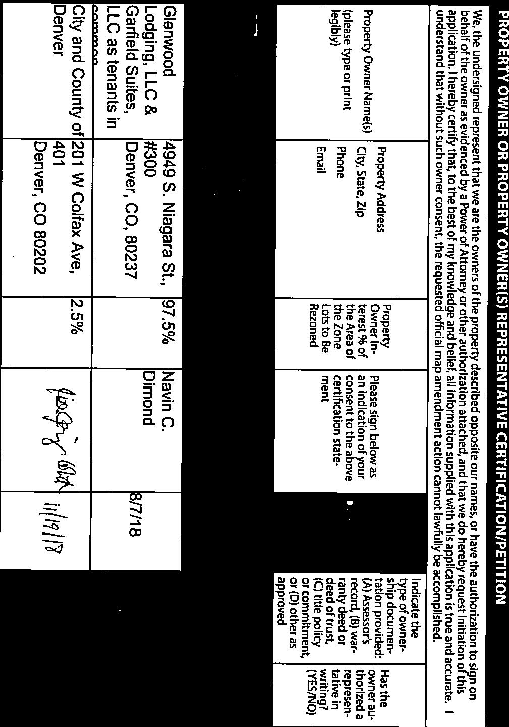
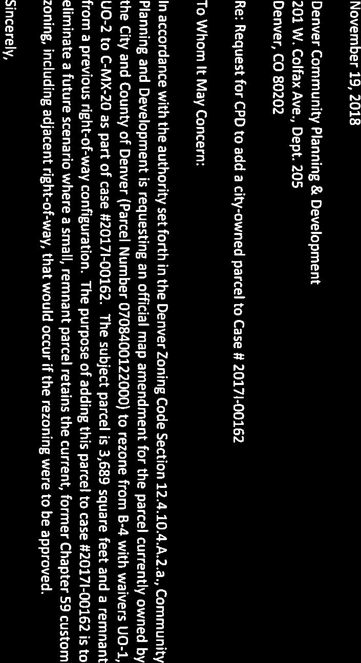
1 Community Planning and Development Planning Services 201 W. Colfax Ave., Dept. 205 Denver, CO p: f: TO: Denver Planning Board FROM: Jeff Hirt, Senior City Planner DATE: November 28, 2018 RE: Official Zoning Map Amendment Application #2017I Rezoning from B-4 with waivers, UO-1, UO-2 to C-MX-20 Staff Report and Recommendation Based on the criteria for review in the Denver Zoning Code, Staff recommends approval for Application #2017I for a rezoning from B-4 with waivers, UO-1, UO-2 to C-MX-20. Request for Rezoning Application: #2017I Address: Neighborhood/Council District: Southmoor Park / Council District 4 RNOs: Inter-Neighborhood Cooperation Area of Properties: 140,315 SF (3.2 acres) Current Zoning: B-4 with waivers, UO-1, UO-2 Proposed Zoning: C-MX-20 Property Owner(s): Glenwood Lodging, LLC and Garfield Suites, LLC Summary of Rezoning Request The property is in the Belleview Station transit-oriented development area, adjacent to a light rail station platform. The property contains a hotel development built in 1995 with three two-story buildings. The Belleview light rail station opened in The applicant is requesting the rezoning to redevelop the property for a mixed-use project. The current B-4 with waivers zoning restricts building heights to 50, with some additional land use limitations. Surrounding properties all have Former Chapter 59 T-MU-30 zoning, which allows building heights up to 220 on properties further from the light rail station platform than the subject property. The C-MX-20 zone district allows building heights of up to 250, while surrounding properties that are a block or more further from the light rail station have a maximum building height zoning entitlement of 220 under the current T-MU-30 zoning. All recently constructed or approved buildings on adjacent blocks are over 200 in height (see Building Heights Context Analysis below). The C-MX-20 building form standards require a high degree of street level activation with low minimum vehicle parking requirements. The zone district allows a wide mix of primarily civic/institutional, residential, and commercial uses. See Denver Zoning Code (DZC) Article 7 for more details about the C-MX-20 zone district.


2 Rezoning Application #2017I November 28, 2018 Page 2

3 Rezoning Application #2017I November 28, 2018 Page 3 Existing Context The subject property is in a rapidly changing transit-oriented development area surrounding the Belleview Station light rail platform. The street network was introduced in the mid-2000s in response to development potential with the newly completed light rail station. Since 2013, several new buildings for mixed use and office land uses have been constructed or approved in the area surrounding the subject property. The following table summarizes the existing context proximate to the subject property, followed by a building-height specific analysis.
4 Rezoning Application #2017I November 28, 2018 Page 4 Site Existing Zoning B-4 with waivers, UO-1, UO-2 Existing Land Uses Mixed Use (Hotel) Existing Building Form/Scale Three two-story buildings as part of a hotel complex built in Vehicular access is off Chenango Avenue and South Quebec Street, with several internal drive aisles accessing surface parking areas. North T-MU-30 with waivers, UO-1 Vacant Vacant parcels are adjacent to the Belleview Station light rail platform. South East West T-MU-30 with waivers, UO-1 OS-B, Arapahoe County enclave T-MU-30 with waivers, UO-1 Office, Vacant RTD Park-n- Ride, Interstate 25 Vacant One 15-story office building built in 2018; one remaining vacant parcel on the same block. Two other nearby blocks south of Chenango Avenue are entirely built out, both with 5-story mixed use buildings built in 2013 and Greenwood Village is one block to the south across Belleview Avenue. Belleview Station Park-n-Ride (59 spaces) that is connected by a sidewalk to the light rail station; Interstate 25 and the light rail tracks; the Park-n-Ride area is part of a 4.6-acre area that is an Arapahoe County enclave surrounded by Denver. Currently vacant 3.8-acre block; however, a site development plan is approved for a 15-story, mixed use building as of October 2018 on the northern half of the block. Existing Block, Lot, and Street Pattern An improved grid network of streets that was completed in the mid-2000 s for development of the area surrounding the Belleview Station light rail platform; Interstate 25 interrupts the street grid immediately to the east of the subject property. Building Heights Context Analysis Surrounding blocks west of Interstate 25 are all zoned T-MU-30, a Former Chapter 59 zone district that allows up to 220 feet in building height. Several surrounding blocks remain vacant with this zoning, and some blocks south of the subject property have developed at heights approaching 220 feet. There are buildings either recently constructed or approved on adjacent blocks of 206 feet/15 stories and 211 feet/15 stories. The tallest building in the area that is in Denver city limits is approximately ½ mile east across I-25 at 257 feet, or 23 stories, located on the southeast corner of Union Avenue and South Ulster Street.


5 Rezoning Application #2017I November 28, 2018 Page Table of Surrounding Property Building Heights
6 Rezoning Application #2017I November 28, 2018 Page 6 1. Existing Zoning B-4 is a Former Chapter 59 business zone district that allows a wide range of nonresidential and residential uses, including multi-unit residential, retail, and office. Structures are regulated by a maximum floor area ratio of 2:1 with bulk plane standards. However, Ordinance Number 604, Series 1994 (see Attachment 2) includes waivers that address both building heights and land uses on the subject property. Specifically, the waivers: Limit building heights to 50 feet and a maximum of 1:1 floor area ratio; Restrict the mix of some allowed uses by specifying that no more than 20% of the gross floor area of a building may be used for uses other than business and personal service uses ; Prohibit some land uses, including light industrial, automobile sales, adult uses, and outdoor general advertising, (aka billboards); and Set forth minimum open space requirements (30%), landscaping requirements including the number of trees and shrubs, and landscaped area setbacks from the street. UO-1 is the Adult Use Overlay District that permits some adult business uses with limitations. However, the subject property s waivers prohibit adult businesses as defined by Former Chapter 59 zoning. UO-2 is the Billboard Use Overlay District that permits outdoor general advertising devices with limitations. However, the subject property s waivers prohibit outdoor general advertising devices as defined by Former Chapter 59 zoning. The applicant is not requesting to include the subject property in either the UO-1 or UO-2 zone district.


7 Rezoning Application #2017I November 28, 2018 Page 7 2. Existing Land Use Map The subject property is in a predominantly commercial, office, and mixed use area with several vacant blocks that are rapidly developing. Within the last 5 years, three blocks south and southwest of the subject property have developed with new mixed use and office buildings. The blocks west and north of the subject property, while vacant, are expected to develop soon if the current pace of development continues. To the east is the Belleview Station Park-n-Ride, light rail platform, and Interstate 25. One block south across Belleview Avenue is the city limits shared with Greenwood Village.


8 Rezoning Application #2017I November 28, 2018 Page 8

 Subject Property Images Subject Property, looking west from Interstate 25")
9 Rezoning Application #2017I November 28, 2018 Page 9 3. Existing Building Form and Scale Images The existing building form and scale of the subject site and adjacent properties are shown in the images on the following pages. (Source: Google Earth) Subject Property Images Subject Property, looking west from Interstate 25 Light Rail Station Subject Property Looking West from S Quebec St


10 Rezoning Application #2017I November 28, 2018 Page 10 Subject Property Looking North from Chenango Ave Subject Property Looking East from Olive St Subject Property Looking South from Olive St, Light Rail Station


11 Rezoning Application #2017I November 28, 2018 Page 11 Surrounding Property Images Subject Property and Surroundings, looking northeast from near Belleview Ave. and Niagara St. Surrounding Property Looking North on S Quebec St


12 Rezoning Application #2017I November 28, 2018 Page 12 Surrounding Property Looking South and East Towards Interstate 25 Surrounding Property Looking South Across Chenango Ave Surrounding Property Looking West

13 Rezoning Application #2017I November 28, 2018 Page 13 Surrounding Property Looking North Summary of City Agency Referral Comments As part of the DZC review process, the rezoning application is referred to potentially affected city agencies and departments for comment. A summary of agency referral responses follows: Assessor: Approved - no comment Real Estate: Approved - no comment Denver Public Schools: Approved - no comment Department of Public Health and Environment: Approved with comments. Denver Department of Public Health and Environment (DDPHE) concurs with the rezoning and is not aware of historical environmental concerns on the Property. General Notes: Most of Colorado is high risk for radon, a naturally occurring radioactive gas. Due to concern for potential radon gas intrusion into buildings, DEH suggests installation of a radon mitigation system in structures planned for human occupation or frequent use. It may be more cost effective to install a radon system during new construction rather than after construction is complete. If renovating or demolishing existing structures, there may be a concern of disturbing regulated materials that contain asbestos or lead-based paint. Materials containing asbestos or lead-based paint should be managed in accordance with applicable federal, state and local regulations. The Denver Air Pollution Control Ordinance (Chapter 4- Denver Revised Municipal Code) specifies that contractors shall take reasonable measures to prevent particulate matter from becoming airborne and to prevent the visible discharge of fugitive particulate emissions beyond the property on which the emissions originate. The measures taken must be effective in the control of fugitive particulate emissions at all times on the site, including periods of inactivity such as evenings, weekends, and holidays. Denver s Noise Ordinance (Chapter 36 Noise Control, Denver Revised Municipal Code) identifies allowable levels of noise. Properties undergoing Re-Zoning may change the acoustic environment, but must maintain compliance with the Noise Ordinance. Compliance with the Noise Ordinance is based on the status of the receptor property (for example, adjacent Residential receptors), and not the status of the noise-generating property. Violations of the Noise Ordinance commonly result from, but are not limited to, the operation or improper placement of HV/AC units, generators, and loading docks. Construction noise is exempted from the Noise Ordinance during the following hours, 7am 9pm (Mon Fri) and 8am 5pm (Sat & Sun). Variances for nighttime work are allowed, but the variance approval
14 Rezoning Application #2017I November 28, 2018 Page 14 process requires 2 to 3 months. For variance requests or questions related to the Noise Ordinance, please contact Paul Riedesel, Denver Environmental Health ( ). Scope & Limitations: DEH performed a limited search for information known to DEH regarding environmental conditions at the subject site. This review was not intended to conform to ASTM standard practice for Phase I site assessments, nor was it designed to identify all potential environmental conditions. In addition, the review was not intended to assess environmental conditions for any potential right-of-way or easement conveyance process. The City and County of Denver provides no representations or warranties regarding the accuracy, reliability, or completeness of the information provided. Parks & Recreation: Approved no comments Public Works Right-of-Way Surveyor: Approved no comments Development Services Transportation: Approved - no comments Development Services Wastewater: Approved with comments. DES Wastewater approves the subject zoning change. The applicant should note that redevelopment of this site may require additional engineering including preparation of drainage reports, construction documents, and erosion control plans. Redevelopment may require construction of water quality and detention basins, public and private sanitary and storm sewer mains, and other storm or sanitary sewer improvements. Redevelopment may also require other items such as conveyance of utility, construction, and maintenance easements. The extent of the required design, improvements and easements will be determined during the redevelopment process. Please note that no commitment for any new sewer service will be given prior to issuance of an approved SUDP from Development Services. Development Services Project Coordination: Approved no comments Development Services Fire Prevention: Approved - no comments Public Review Process Date CPD informational notice of receipt of the rezoning application to all affected members of City Council and registered neighborhood organizations Property legally posted for a period of 15 days and CPD written notice of the Planning Board public hearing sent to all affected members of City Council and registered neighborhood organizations 9/6/18 11/19/18 Planning Board public hearing 12/5/18 CPD written notice of the Land Use, Transportation and Infrastructure Committee meeting sent to all affected members of City Council and registered neighborhood organizations, at least ten working days before the meeting (tentative) Land Use, Transportation and Infrastructure Committee of the City Council review (tentative) 12/4/18 12/18/18
15 Rezoning Application #2017I November 28, 2018 Page 15 Property legally posted for a period of 21 days and CPD written notice of the City Council 1/7/19 public hearing sent to all affected members of City Council and registered neighborhood organizations (tentative) City Council Public Hearing (tentative) 1/28/19 The RNOs identified on page 1 were notified of this application. As of the date of this staff report, city staff has not received any public comments. Criteria for Review / Staff Evaluation The criteria for review of this rezoning application are found in DZC, Sections and , as follows: DZC Section Consistency with Adopted Plans 2. Uniformity of District Regulations and Restrictions 3. Public Health, Safety and General Welfare DZC Section Justifying Circumstances 2. Consistency with Neighborhood Context Description, Zone District Purpose and Intent Statements 1. Consistency with Adopted Plans The following adopted plans apply to this property: Denver Comprehensive Plan 2000 Blueprint Denver (2002) Denver Comprehensive Plan 2000 The request is consistent with several Denver Comprehensive Plan strategies, including: Environmental Sustainability Strategy 2-F: o Conserve land by promoting infill development at sites where services and infrastructure are already in place (p. 39). Date o Conserve land by creating more density at transit nodes (p. 39). Business Centers Strategy 3-B: Encourage quality infill development that is consistent with the character of the surrounding neighborhood; that offers opportunities for increased density and more amenities; and that broadens the variety of compatible uses (p. 60). Land Use and Transportation Strategy 4-A: Encourage mixed-use, transit-oriented development that makes effective use of existing transportation infrastructure, supports transit stations, increases transit patronage, reduces impact on the environment, and encourages vibrant urban centers and neighborhoods (p. 60). Land Use and Transportation Strategy 4-B: Ensure that land-use policies and decisions support a variety of mobility choices, including light rail, buses, paratransit, walking and bicycling, as well as convenient access for people with disabilities (p. 60).
16 Rezoning Application #2017I November 28, 2018 Page 16 Diverse Mobility Options Strategy 1-B: Promote public transit, both bus and rail, as a safe, attractive and convenient choice for people who might otherwise drive to employment, education, cultural, shopping or other destinations (p. 75). Accommodating New Development Strategy 3-B: Promote transit-oriented development (TOD) as an urban design framework for urban centers and development areas. Development at transit stations should provide both higher ridership to the transit system and viability and walkability in the area (P. 76). Public Transit Strategy 5-D: Determine the potential for transit-oriented development at public transit stations, and encourage such opportunities whenever possible (p. 79). The proposed map amendment would promote transit-oriented infill development at a location where services and infrastructure are in place to serve the property and with excellent mobility options. The subject property is adjacent to the Belleview Station light rail platform and is well connected to the area s street network and the nearby Belleview Avenue and I-25 interchange. The proposed map amendment would support public transit by allowing more development intensity at a transit node that is consistent with the character of the surrounding neighborhood. Blueprint Denver (2002) According to Blueprint Denver, these sites have a concept land use of Transit Oriented Development and are located within an Area of Change. Future Land Use Blueprint Denver describes Transit-Oriented Development as areas where land uses have a direct correlation to the function of a mass transit system. These development sites are located at stations or stops along bus or rail lines within a mass transit network. Some key attributes of TOD commonly include a balanced mix of uses and compact, mid- to high-density development (p. 44). Typical development intensities are between a 0.5:1 and 4:1 Floor Area Ratio (p. 64). Area of Change The site is in an Area of Change. Areas of Change are parts of the city where new growth and redevelopment can best be accommodated because there is existing infrastructure in the area and sites have not realized their full development potential. Certain features characterize an Area of Change, such as areas adjacent to and around transit stations (p. 19). According to Blueprint Denver, in this Southeast Light Rail Corridor TOD Area of Change, Along the I-25 Corridor south of Broadway, there are several TOD opportunities. The Colorado Station area and the Belleview Station area offer the greatest potential for larger-scale TOD development. Both areas have the potential to create a mixed-use urban village centered around the light-rail station (p. 138). Street Classifications The streets in the Belleview Station area surrounding the subject property were constructed after the adoption of Blueprint Denver in 2002, so the street network is only partially mapped at this location. Quebec Street, portions of Chenango Avenue, and the internal drive aisles serving the existing development are all classified by Blueprint Denver as Undesignated Local Streets. Blueprint Denver states, the design features of local streets are influenced less by traffic volumes and are tailored more to providing local access. Mobility on local streets is typically incidental and involves relatively short trips at lower speeds to and from other streets (p. 51).
.")
17 Rezoning Application #2017I November 28, 2018 Page 17 Additional Relevant Blueprint Denver Policies: o o o Denver 2020 Vision: Appropriately located and attractive density stimulates positive change and development in areas with strong links to transit (p. 18). Priority Actions for Public Transportation: o Support development of transit services, including regional rapid transit, enhanced bus corridors, local circulators and transit-supportive land use (p. 166). o Support zoning changes, development incentives, and other transit-supportive strategies to achieve a Transit-Oriented Development (TOD) in rail station areas and at other key transit locations (p. 167). Transit Oriented Development Definition: Form of development that maximizes the benefits from the investment in transit infrastructure by concentrating the most intense types of development around transit stations to promote increase transit use (p. 189). The request is consistent with Blueprint Denver policies for the following reasons: o Regarding the Transit Oriented Development (TOD) future land use classification, the rezoning would support mid- to high-density development at a location adjacent to a rail line that is part of a mass transit network;

18 Rezoning Application #2017I November 28, 2018 Page 18 o o o Regarding the Area of Change classification, the rezoning would accommodate development on a site with existing infrastructure that has not realized its full development potential in an area of the greatest potential for TOD. The current B-4 with Waivers zoning limits building heights to 50 feet, which is inconsistent with the site s adjacency to the light rail station, the surrounding building height allowances of 220, and Blueprint policies identifying this area as desirable for increased development intensities; and The rezoning would eliminate a custom, Former Chapter 59 Zone District and bring the site into the Denver Zoning Code, which is consistent with the Blueprint Denver policy that Former Chapter 59 zoning, and particularly custom zoning, is out of step with the Blueprint Denver vision (pp. 72, 82). Transit Oriented Development (TOD) Strategic Plan (2014) The TOD Strategic Plan is not an adopted plan, but it does reflect the outcome of a multi-agency, mayor-led initiative to provide a foundation to guide public and private investment at rail stations. The purpose of the plan is to act as a guide to direct growth and investment to rail stations with the best opportunity for development in the next 5 to 6 years (p. 4). The subject property is in the Belleview Station Typology area, which the TOD Strategic Plan identifies as an Urban Center. Urban Center stations are intended to be mixed use, high density, grid and alley block pattern, high pedestrian activity, and multimodal (p. 19). Building heights are anticipated up to a maximum of 20 stories at the core of the TOD area (p. 22).
19 Rezoning Application #2017I November 28, 2018 Page Uniformity of District Regulations and Restrictions The proposed rezoning to C-MX-20 would result in the uniform application of zone district building form, use, and design regulations for the subject property. 3. Public Health, Safety and General Welfare The proposed official map amendment would further the public health, safety, and general welfare of the City through implementation of adopted plans. Specifically, the request will eliminate custom, Former Chapter 59 zoning that precludes increased development intensity by restricting building heights. Both Blueprint Denver and the Comprehensive Plan policies support increased development intensity on the subject property. 4. Justifying Circumstance The rezoning is justified under DZC Section A.4, Since the date of the approval of the existing Zone District, there has been a change to such a degree that the proposed rezoning is in the public interest. Such change may include: Changed or changing conditions in a particular area; or That the City adopted the Denver Zoning Code and the property retained Former Chapter 59 zoning. The subject property retained Former Chapter 59 zoning with the adoption of the Denver Zoning Code in The surrounding blocks have also changed to a degree that the proposed rezoning is in the public interest. The adjacent light rail station is resulting in the transformation of this area that has accelerated recently, with four site development plans for significant new development projects approved on adjacent blocks in the last five years. 5. Consistency with Neighborhood Context Description, Zone District Purpose and Intent Statements The requested C-MX-20 zone district is in the Urban Center Neighborhood Context, which consists of multi-unit residential, mixed use, and commercial centers. All buildings typically have consistent orientation and shallow front setbacks with parking at the rear and/or side of the building. There are high levels of pedestrian and bicycle use with the greatest access to multi-modal transportation system. C-MX-20 applies to areas or intersections served primarily by major arterial streets where a building scale of 3 to 20 stories is desired. The request is consistent with the Urban Center Neighborhood Context description because it promotes mixed use development in area where an adopted plan expresses strong desire for larger-scale TOD with exceptional access to a multi-modal transportation system, including the adjacent light rail station and Belleview Avenue, which is one block away and classified in Blueprint Denver as a Mixed Use Arterial. Attachments 1. Rezoning application 2. Waiver (Ordinance 604 Series of 1994)
20 Zone Map Amendment (Rezoning) - Application COMMUNITY PLANNING & DEVELOPMENT REZONING GUIDE Rezoning Application Page 1 of 3 PROPERTY OWNER INFORMATION* CHECK IF POINT OF CONTACT FOR APPLICATION Property Owner Name Address City, State, Zip Telephone PROPERTY OWNER(S) REPRESENTATIVE** CHECK IF POINT OF CONTACT FOR APPLICATION Representative Name Address City, State, Zip Telephone *If More Than One Property Owner: All standard zone map amendment applications shall be initiated by all the owners of at least 51% of the total area of the zone lots subject to the rezoning application, or their representatives authorized in writing to do so. See page 3. **Property owner shall provide a written letter authorizing the representative to act on his/her behalf. Please attach Proof of Ownership acceptable to the Manager for each property owner signing the application, such as (a) Assessor s Record, (b) Warranty deed or deed of trust, or (c) Title policy or commitment dated no earlier than 60 days prior to application date. If the owner is a corporate entity, proof of authorization for an individual to sign on behalf of the organization is required. This can include board resolutions authorizing the signer, bylaws, a Statement of Authority, or other legal documents as approved by the City Attorney s Office. SUBJECT PROPERTY INFORMATION Location (address and/or boundary description): Assessor s Parcel Numbers: Area in Acres or Square Feet: Current Zone District(s): PROPOSAL Proposed Zone District: Last updated: May 24, 2018 Return completed form to rezoning@denvergov.org 201 W. Colfax Ave., Dept. 205 Denver, CO rezoning@denvergov.org

21 COMMUNITY PLANNING & DEVELOPMENT REZONING GUIDE Rezoning Application Page 2 of 3 REVIEW CRITERIA General Review Criteria: The proposal must comply with all of the general review criteria DZC Sec Additional Review Criteria for Non-Legislative Rezonings: The proposal must comply with both of the additional review criteria DZC Sec REQUIRED ATTACHMENTS Consistency with Adopted Plans: The proposed official map amendment is consistent with the City s adopted plans, or the proposed rezoning is necessary to provide land for a community need that was not anticipated at the time of adoption of the City s Plan. Please provide an attachment describing relevant adopted plans and how proposed map amendment is consistent with those plan recommendations; or, describe how the map amendment is necessary to provide for an unanticipated community need. Uniformity of District Regulations and Restrictions: The proposed official map amendment results in regulations and restrictions that are uniform for each kind of building throughout each district having the same classification and bearing the same symbol or designation on the official map, but the regulations in one district may differ from those in other districts. Public Health, Safety and General Welfare: The proposed official map amendment furthers the public health, safety, and general welfare of the City. Justifying Circumstances - One of the following circumstances exists: The existing zoning of the land was the result of an error. The existing zoning of the land was based on a mistake of fact. The existing zoning of the land failed to take into account the constraints on development created by the natural characteristics of the land, including, but not limited to, steep slopes, floodplain, unstable soils, and inadequate drainage. Since the date of the approval of the existing Zone District, there has been a change to such a degree that the proposed rezoning is in the public interest. Such change may include: a. Changed or changing conditions in a particular area, or in the city generally; or, b. A City adopted plan; or c. That the City adopted the Denver Zoning Code and the property retained Former Chapter 59 zoning. It is in the public interest to encourage a departure from the existing zoning through application of supplemental zoning regulations that are consistent with the intent and purpose of, and meet the specific criteria stated in, Article 9, Division 9.4 (Overlay Zone Districts), of this Code. Please provide an attachment describing the justifying circumstance. The proposed official map amendment is consistent with the description of the applicable neighborhood context, and with the stated purpose and intent of the proposed Zone District. Please provide an attachment describing how the above criterion is met. Please ensure the following required attachments are submitted with this application: Legal Description (required to be attached in Microsoft Word document format) Proof of Ownership Document(s) Review Criteria, as identified above ADDITIONAL ATTACHMENTS Please identify any additional attachments provided with this application: Written Authorization to Represent Property Owner(s) Individual Authorization to Sign on Behalf of a Corporate Entity Please list any additional attachments: Last updated: May 24, 2018 Return completed form to rezoning@denvergov.org 201 W. Colfax Ave., Dept. 205 Denver, CO rezoning@denvergov.org


22
23


24
25
26 Legal Description: A parcel of land located in the Southeast 1/4 of Section 8, Township 5 South, Range 67 West of the 6th Principal Meridian, City and County of Denver State of Colorado. More particularly described as follows: COMMENCING at the Southeast comer of said Section 8: Thence North 00 17' 48" West along the East line of the Southeast 1/4 of said Section 8, a distance of feet; Thence South 89 35' 29" West departing said East line, a distance of feet to the POINT OF BEGINNING; Thence South 89 35' 29" West a distance of feet; Thence South 00 17' 48" East, a distance of feet to a point on a curve from whence the center of said curve bears South 00 17' 48" East, a distance of feet: Thence along said curve to the right having a radius of feet, a central angle of 12 04' 36", an arc distance of feet to a point of reverse curvature: Thence along a curve to the left having a radius of feet, a central angle of 10 29'18", an arc distance of feet to a point of compound curvature: Thence along a curve to the left having a radius of feet, a central angle of 91 36' 06", an arc distance of feet to a point on the West right-of-way line of South Quebec Street; Thence the following three (3) courses along said right-of-way line: (1) North 00 17' 48" West a distance of feet to a point of a curve from whence the center of said curve bears North 18 30' 23" East a distance of feet: (2) Thence along a curve to the right having a radius of feet, a central angle of ' 49", an arc distance of feet; (3) Thence North 00 17' 48" West. a distance of 4.24 feet to the POINT OF BEGINNING, City and County of Denver, State of Colorado.
27
28
29
30
31
32
33
34
35
36
Land Use, Transportation, and Infrastructure Committee of the Denver City Council FROM: Scott Robinson, Senior City Planner DATE: March 22, 2018 RE:
 Community Planning and Development Planning Services 201 W. Colfax Ave., Dept. 205 Denver, CO 80202 p: 720.865.2915 f: 720.865.3052 www.denvergov.org/cpd TO: Land Use, Transportation, and Infrastructure
Land Use, Transportation, and Infrastructure Committee of Denver City Council FROM: Scott Robinson, Senior City Planner DATE: December 6, 2018 RE:
 Community Planning and Development Planning Services 201 W. Colfax Ave., Dept. 205 Denver, CO 80202 p: 720.865.2915 f: 720.865.3052 www.denvergov.org/cpd TO: Land Use, Transportation, and Infrastructure
Denver City Council Land Use, Transportation, and Infrastructure Committee FROM: Courtney Levingston, Senior City Planner DATE: July 26, 2018 RE:
 TO: Denver City Council Land Use, Transportation, and Infrastructure Committee FROM: Courtney Levingston, Senior City Planner DATE: RE: Official Zoning Map Amendment Application #2017I-00151 Staff Report
Official Zoning Map Amendment Application #2017I Gaylord Street and York Street Rezoning from U-RH-2.5 to U-RX-3 and U-RX-5
 Community Planning and Development Planning Services 201 W. Colfax Ave., Dept. 205 Denver, CO 80202 p: 720.865.2915 f: 720.865.3052 www.denvergov.org/cpd TO: Denver Planning Board FROM: Elizabeth Weigle,
Land Use, Transportation, & Infrastructure Committee of the Denver City Council FROM: Chandler Van Schaack, Senior City Planner DATE: July 3, 2018 RE:
 Community Planning and Development Planning Services TO: Land Use, Transportation, & Infrastructure Committee of the Denver City Council FROM: Chandler Van Schaack, Senior City Planner DATE: July 3, 2018
Staff Report and Recommendation Based on the criteria for review in the Denver Zoning Code, Staff recommends approval for Application #2017I
 TO: Denver Planning Board, Joel Noble, Chair FROM: Theresa Lucero, Senior City Planner DATE: RE: Official Zoning Map Amendment Application #2017I-00163 Staff Report and Recommendation Based on the criteria
Official Zoning Map Amendment Application #2018I-00120
 Community Planning and Development Planning Services 201 W. Colfax Ave., Dept. 205 Denver, CO 80202 p: 720.865.2915 f: 720.865.3052 www.denvergov.org/cpd TO: Denver Planning Board FROM: Scott Robinson,
Brad Buchanan, Executive Director, Department of Community Planning and Development
 TO: City Council FROM: Jeff Hirt, Senior City Planner DATE: RE: Official Zoning Map Amendment Application #2017I-00076 3400 Arkins Ct., 3460 Arkins Ct., 1900 35 th St, 1930 35th St., 1950 35 th St Rezoning
REZONING GUIDE. Zone Map Amendment (Rezoning) - Application. Rezoning Application Page 1 of 3. Return completed form to
 - Application. Rezoning Application Page 1 of 3. Return completed form to") Zone Map Amendment (Rezoning) - Application COMMUNITY PLANNING & DEVELOPMENT REZONING GUIDE Rezoning Application Page 1 of 3 PROPERTY OWNER INFORMATION* CHECK IF POINT OF CONTACT FOR APPLICATION Property
Zone Map Amendment (Rezoning) - Application COMMUNITY PLANNING & DEVELOPMENT REZONING GUIDE Rezoning Application Page 1 of 3 PROPERTY OWNER INFORMATION* CHECK IF POINT OF CONTACT FOR APPLICATION Property
REZONING GUIDE. Zone Map Amendment (Rezoning) - Application. Rezoning Application Page 1 of 3. Return completed form to
 - Application. Rezoning Application Page 1 of 3. Return completed form to") COMMUNITY PLANNING & DEVELOPMENT REZONING GUIDE Rezoning Application Page 1 of 3 Zone Map Amendment (Rezoning) - Application PROPERTY OWNER INFORMATION* PROPERTY OWNER(S) REPRESENTATIVE** CHECK IF POINT
COMMUNITY PLANNING & DEVELOPMENT REZONING GUIDE Rezoning Application Page 1 of 3 Zone Map Amendment (Rezoning) - Application PROPERTY OWNER INFORMATION* PROPERTY OWNER(S) REPRESENTATIVE** CHECK IF POINT
Representative Name. Address. City, State, Zip. Telephone.
 COMMUNITY PLANNING & DEVELOPMENT ~~DENVER... THE MILE HIGH CITY REZONING GUIDE Zone Map Amendment (Rezoning)- Application Rezoning Application Page 1 of 3 Property Owner Name Philip M. Falco Address 730
Official Zoning Map Amendment Application #2018I-00067
 Community Planning and Development Planning Services 201 W. Colfax Ave., Dept. 205 Denver, CO 80202 p: 720.865.2915 f: 720.865.3052 www.denvergov.org/cpd TO: Denver Planning Board FROM: Courtney Levingston,
Official Zoning Map Amendment Application #2017I-00094
 Community Planning and Development Planning Services 201 W. Colfax Ave., Dept. 205 Denver, CO 80202 p: 720.865.2915 f: 720.865.3052 www.denvergov.org/cpd TO: Denver Planning Board FROM: Scott Robinson,
REZONING GUIDE. Zone Map Amendment (Rezoning) - Application. Rezoning Application Page 1 of 3. Return completed form to
 - Application. Rezoning Application Page 1 of 3. Return completed form to") Zone Map Amendment (Rezoning) - Application COMMUNITY PLANNING & DEVELOPMENT REZONING GUIDE Rezoning Application Page 1 of 3 PROPERTY OWNER INFORMATION* CHECK IF POINT OF CONTACT FOR APPLICATION Property
Zone Map Amendment (Rezoning) - Application COMMUNITY PLANNING & DEVELOPMENT REZONING GUIDE Rezoning Application Page 1 of 3 PROPERTY OWNER INFORMATION* CHECK IF POINT OF CONTACT FOR APPLICATION Property
To: S-MX-8 AIO, S-MX-8A AIO, S-MX-12 AIO, C-MX-8 AIO, C-MX-12 AIO, and S-CC-5 AIO
 Community Planning and Development Planning Services 201 W. Colfax Ave., Dept. 205 Denver, CO 80202 p: 720.865.2915 f: 720.865.3052 www.denvergov.org/cpd TO: Denver City Council FROM: Curt Upton, Senior
Request for Rezoning. Current Zoning: Proposed Zoning:
 TO: Denver City Council, Neighborhoods and Planning Committee FROM: Theresa Lucero, Senior City Planner DATE: March 31, 2016 RE: Zoning Map Amendment #2015I-00150 Rezoning from M-RX-5 to I-MX-3 Community
Official Zoning Map Amendment Application #2017I-00090
 Community Planning and Development Planning Services 201 W. Colfax Ave., Dept. 205 Denver, CO 80202 p: 720.865.2915 f: 720.865.3052 www.denvergov.org/cpd TO: Land Use, Transportation, & Infrastructure
Telephone AC / 21,960 SF G-MU-3 G-MX-3
 Zone Map Amendment (Rezoning) - Application PROPERTY OWNER INFORMATION* CHECK IF POINT OF CONTACT FOR APPLICATION Property Owner Name Siddhartha Rathod Address City, State, Zip Telephone Email COMMUNITY
Staff Report and Recommendation Based on the criteria for review in the Denver Zoning Code, Staff recommends approval for application #2017I
 TO: Denver City Council, Land Use, Transportation and Infrastructure Committee FROM: Theresa Lucero, Senior City Planner DATE: RE: Official Zoning Map Amendment Application #2017I-00153 Staff Report and
Based on the criteria for review in the Denver Zoning Code, Staff recommends approval for Application #2018I
 Community Planning and Development Planning Services 201 W. Colfax Ave., Dept. 205 Denver, CO 80202 p: 720.865.2915 f: 720.865.3052 www.denvergov.org/cpd TO: Denver Planning Board FROM: Chandler Van Schaack,
Staff Report and Recommendation
 Community Planning and Development Planning Services 201 W. Colfax Ave., Dept. 205 Denver, CO 80202 p: 720.865.2915 f: 720.865.3052 www.denvergov.org/cpd TO: Denver Planning Board FROM: Andrew Webb, Senior
Official Zoning Map Amendment Application #2018I-00095
 Community Planning and Development Planning Services 201 W. Colfax Ave., Dept. 205 Denver, CO 80202 p: 720.865.2915 f: 720.865.3052 www.denvergov.org/cpd TO: Denver Planning Board FROM: Ella Stueve, Senior
Block bounded by Newton St., 17 th Ave., Lowell Blvd., and 16 th Ave.; plus Meade Street (evens only)
") Community Planning and Development Planning Services 201 W. Colfax Ave., Dept. 205 Denver, CO 80202 p: 720.865.2915 f: 720.865.3052 www.denvergov.org/cpd TO: Denver Planning Board FROM: Sara White, AICP,
Community Planning and Development Planning Services 201 W. Colfax Ave., Dept. 205 Denver, CO 80202 p: 720.865.2915 f: 720.865.3052 www.denvergov.org/cpd TO: Denver Planning Board FROM: Sara White, AICP,
REZONING GUIDE. Zone Map Amendment (Rezoning) - Application. Rezoning Application Page 1 of 3. Return completed form to
 - Application. Rezoning Application Page 1 of 3. Return completed form to") Zone Map Amendment (Rezoning) - Application COMMUNITY PLANNING & DEVELOPMENT REZONING GUIDE Rezoning Application Page 1 of 3 PROPERTY OWNER INFORMATION* CHECK IF POINT OF CONTACT FOR APPLICATION Property
Zone Map Amendment (Rezoning) - Application COMMUNITY PLANNING & DEVELOPMENT REZONING GUIDE Rezoning Application Page 1 of 3 PROPERTY OWNER INFORMATION* CHECK IF POINT OF CONTACT FOR APPLICATION Property
Official Zoning Map Amendment Application #2015I Marion St. Rezoning from U-SU-A1 to U-MX-2x
 Community Planning and Development Planning Services 201 W. Colfax Ave., Dept. 205 Denver, CO 80202 p: 720.865.2915 f: 720.865.3052 www.denvergov.org/cpd TO: Denver City Council FROM: Courtland Hyser,
E-SU-A. Zone Map Amendment (Rezoning) -Application E-SU-B. Rf tum cornpleted form to rezoning(i:})denvergov.org. *If More Than One Property Owner;
 -Application E-SU-B. Rf tum cornpleted form to rezoning(i:})denvergov.org. *If More Than One Property Owner;") Zone Map Amendment (Rezoning) -Application Property Owner Name Philip M. Falco Representative Name Address 730 17th Street, Suite 900 Address City, State, Zip Denver, CO 80202 City, State, Zip Telephone
Zone Map Amendment (Rezoning) -Application Property Owner Name Philip M. Falco Representative Name Address 730 17th Street, Suite 900 Address City, State, Zip Denver, CO 80202 City, State, Zip Telephone
Article 3. SUBURBAN (S-) NEIGHBORHOOD CONTEXT
 NEIGHBORHOOD CONTEXT") Article 3. SUBURBAN (S-) NEIGHBORHOOD CONTEXT this page left intentionally blank Contents ARTICLE 3. SUBURBAN (S-) NEIGHBORHOOD CONTEXT DIVISION 3.1 NEIGHBORHOOD CONTEXT DESCRIPTION...3.1-1 Section 3.1.1
Article 3. SUBURBAN (S-) NEIGHBORHOOD CONTEXT this page left intentionally blank Contents ARTICLE 3. SUBURBAN (S-) NEIGHBORHOOD CONTEXT DIVISION 3.1 NEIGHBORHOOD CONTEXT DESCRIPTION...3.1-1 Section 3.1.1
E-SU-A. Zone Map Amendment (Rezoning) -Application E-SU-B. Rf tum cornpleted form to rezoning(i:})denvergov.org. *If More Than One Property Owner;
 -Application E-SU-B. Rf tum cornpleted form to rezoning(i:})denvergov.org. *If More Than One Property Owner;") Zone Map Amendment (Rezoning) -Application Property Owner Name Philip M. Falco Representative Name Address 730 17th Street, Suite 900 Address City, State, Zip Denver, CO 80202 City, State, Zip Telephone
Zone Map Amendment (Rezoning) -Application Property Owner Name Philip M. Falco Representative Name Address 730 17th Street, Suite 900 Address City, State, Zip Denver, CO 80202 City, State, Zip Telephone
REZONING GUIDE. Zone Map Amendment (Rezoning) - Application. Rezoning Application Page 1 of 3. Return completed form to
 - Application. Rezoning Application Page 1 of 3. Return completed form to") Zone Map Amendment (Rezoning) - Application COMMUNITY PLANNING & DEVELOPMENT REZONING GUIDE Rezoning Application Page 1 of 3 PROPERTY OWNER INFORMATION* CHECK IF POINT OF CONTACT FOR APPLICATION Property
Zone Map Amendment (Rezoning) - Application COMMUNITY PLANNING & DEVELOPMENT REZONING GUIDE Rezoning Application Page 1 of 3 PROPERTY OWNER INFORMATION* CHECK IF POINT OF CONTACT FOR APPLICATION Property
PLANNED UNIT DEVELOPMENT & SUBDIVISION STAFF REPORT Date: April 18, 2019
 PLANNED UNIT DEVELOPMENT & SUBDIVISION STAFF REPORT Date: April 18, 2019 DEVELOPMENT NAME SUBDIVISION NAME Springhill Village Subdivision Springhill Village Subdivision LOCATION 4350, 4354, 4356, 4358,
REZONING GUIDE. Zone Map Amendment (Rezoning) - Application. Applicant: Albus Brooks, Councilman District 9
 - Application. Applicant: Albus Brooks, Councilman District 9") Zone Map Amendment (Rezoning) - Application COMMUNITY PLANNING & DEVELOPMENT REZONING GUIDE Rezoning Application Page 1 of 3 PROPERTY OWNER INFORMATION* CHECK IF POINT OF CONTACT FOR APPLICATION Property
Zone Map Amendment (Rezoning) - Application COMMUNITY PLANNING & DEVELOPMENT REZONING GUIDE Rezoning Application Page 1 of 3 PROPERTY OWNER INFORMATION* CHECK IF POINT OF CONTACT FOR APPLICATION Property
Zone Map Amendment (Rezoning) for PUD - Application York St. U-MX-3, B-2 with Waivers. General PUD. Yes. See Attachment C U-MX-3, I-MX-3
 for PUD - Application York St. U-MX-3, B-2 with Waivers. General PUD. Yes. See Attachment C U-MX-3, I-MX-3") COMMUNITY PLANNING & DEVELOPMENT REZONING GUIDE Rezoning Application for PUD Page 1 of 3 Zone Map Amendment (Rezoning) for PUD - Application PROPERTY OWNER INFORMATION* CHECK IF POINT OF CONTACT FOR APPLICATION
COMMUNITY PLANNING & DEVELOPMENT REZONING GUIDE Rezoning Application for PUD Page 1 of 3 Zone Map Amendment (Rezoning) for PUD - Application PROPERTY OWNER INFORMATION* CHECK IF POINT OF CONTACT FOR APPLICATION
Public Review of the Slot Home Text Amendment
 Public Review of the Slot Home Text Amendment The proposed amendments to the Denver Zoning Code have been informed by the Slot Home Strategy Report. This document has been developed out of a robust process
PLANNING COMMISSION STAFF REPORT
 PLANNING COMMISSION STAFF REPORT REZONING CASE: RZ-16-001 REPORT DATE: March 8, 2016 CASE NAME: Trailbreak Partners Rezoning PLANNING COMMISSION DATE: March 16, 2016 ADDRESSES OF REZONING PROPOSAL: 5501
PLANNING COMMISSION STAFF REPORT
 PLANNING COMMISSION STAFF REPORT West Capitol Hill Zoning Map Amendment Petition No. PLNPCM2011-00665 Located approximately at 548 W 300 North Street, 543 W 400 North Street, and 375 N 500 West Street
Conditional Use Permit case no. CU 14-06: Bristol Village Partners, LLC
 PLANNING AND ZONING COMMISSION STAFF REPORT August 7, 2014 Conditional Use Permit case no. CU 14-06: Bristol Village Partners, LLC CASE DESCRIPTION: LOCATION: LEGAL DESCRIPTION: EXISTING LAND USE: ZONING:
City Council Land Use, Transportation, and Infrastructure Committee FROM: Jeff Hirt, Senior City Planner DATE: March 9, 2018 RE:
 TO: City Council Land Use, Transportation, and Infrastructure Committee FROM: Jeff Hirt, Senior City Planner DATE: March 9, 2018 RE: Official Zoning Map Amendment #2015I-00168 Community Planning and Development
PERMITTED USES: Within the MX-1 Mixed Use Neighborhood District the following uses are permitted:
 6.25 MX-1 - MIXED USE NEIGHBORHOOD 6.25.1 INTENT: The purpose of the MX-1 Mixed Use Neighborhood District is to accommodate the development of a wide-range of residential and compatible non-residential
Official Zoning Map Amendment Application #2015I N. King Street and 3441 W. 39 th Ave Rezoning from PUD 406 to U-SU-B1
 Community Planning and Development Planning Services 201 W. Colfax Ave., Dept. 205 Denver, CO 80202 p: 720.865.2915 f: 720.865.3052 www.denvergov.org/cpd TO: Neighborhoods and Planning Committee FROM:
H-POLICY 1: Preserve and improve existing neighborhoods. Ensure that Prince William County achieves new neighborhoods with a high quality of life.
 HOUSING Intent The intent of the Housing Plan is to provide a framework for providing for the housing needs of all residents of Prince William County. These needs are expressed in terms of quality, affordability,
PLANNING COMMISSION REPORT Regular Agenda -Public Hearing Item
 PDP-13-00518 Item No. 3B- 1 PLANNING COMMISSION REPORT Regular Agenda -Public Hearing Item PC Staff Report 2/24/14 ITEM NO. 3B PRELIMINARY DEVELOPMENT PLAN FOR HERE @ KANSAS; 1101 INDIANA ST (SLD) PDP-13-00518:
ZONING AMENDMENT & SUBDIVISION STAFF REPORT Date: November 3, 2016
 ZONING AMENDMENT & SUBDIVISION STAFF REPORT Date: November 3, 2016 APPLICANT NAME SUBDIVISION NAME David Shumer 5955 Airport Subdivision CITY COUNCIL DISTRICT District 6 5955 Airport Boulevard, 754 Linlen
Article 6. GENERAL URBAN (G-) NEIGHBORHOOD CONTEXT
 NEIGHBORHOOD CONTEXT") Article 6. GENERAL URBAN (G-) NEIGHBORHOOD CONTEXT this page left intentionally blank Contents ARTICLE 6. GENERAL URBAN (G-) NEIGHBORHOOD CONTEXT DIVISION 6.1 NEIGHBORHOOD CONTEXT DESCRIPTION...6.1-1 Section
Article 6. GENERAL URBAN (G-) NEIGHBORHOOD CONTEXT this page left intentionally blank Contents ARTICLE 6. GENERAL URBAN (G-) NEIGHBORHOOD CONTEXT DIVISION 6.1 NEIGHBORHOOD CONTEXT DESCRIPTION...6.1-1 Section
CITY PLANNING COMMISSION COMPREHENSIVE PLAN AND REVIEW CRITERIA
 Page 3 CITY PLANNING COMMISSION COMPREHENSIVE PLAN AND REVIEW CRITERIA COMPREHENSIVE PLAN: The City Planning Commission uses the Comprehensive Plan as a guide in all land use matters. The Plan is available
8/17/16 PC Meeting 1
 1 GENERAL INFORMATION OWNER/APPLICANT: Thomas Corff & Terry Moberly (1943 13 th St.) 19328 Towercrest Dr. Oregon City, OR 97045 Michael & Jill Parker (1983 13 th St.) 1708 Oak St. Lake Oswego, OR 97034
CHAPTER XVIII SITE PLAN REVIEW
 CHAPTER XVIII SITE PLAN REVIEW Section 18.1 Section 18.2 Description and Purpose. The purpose of this chapter is to provide standards and procedures under which applicants would submit, and the Township
ZONING AMENDMENT & SUBDIVISION STAFF REPORT Date: July 9, 2015
 ZONING AMENDMENT & SUBDIVISION STAFF REPORT Date: July 9, 2015 APPLICANT NAME 2513 Dauphin Street, Inc. SUBDIVISION NAME Audubon Place Extension No. 3, Resubdivision of Lots 1-5 LOCATION 2513 Dauphin Street
THE BEST WAY TO PREDICT THE FUTURE IS TO CREATE IT.
 THE BEST WAY TO PREDICT THE FUTURE IS TO CREATE IT. - Peter Drucker The premier office environment in the Southeast Denver Corridor. Designed to serve as an optimized platform for our tenants performance
THE WHEELER BUILDING SUBDIVISION
 THE WHEELER BUILDING SUBDIVISION Engineering Comments: FINAL PLAT COMMENTS (should be addressed prior to submitting the FINAL PLAT for review and/or signature by the City Engineer): A. Provide all of the
Rapid City Planning Commission Conditional Use Permit Project Report
 Rapid City Planning Commission Conditional Use Permit Project Report September 21, 2017 Applicant Request(s) Case # 17UR020 Conditional Use Permit to allow a mini-storage facility Companion Case(s) # Item
TRANSIT-ORIENTED DEVELOPMENT PLAN EXISTING CONDITIONS REPORT LAWRENCE TO BRYN MAWR MODERNIZATION
 TRANSIT-ORIENTED DEVELOPMENT PLAN EXISTING CONDITIONS REPORT LAWRENCE TO BRYN MAWR MODERNIZATION March 2018- FINAL DRAFT SITE SPECIFIC DEVELOPMENT CONCEPTS SITE SPECIFIC DEVELOPMENT CONCEPTS This report
Planning Department Oconee County, Georgia
 Planning Department Oconee County, Georgia STAFF REPORT REZONE CASE #: 6985 DATE: October 31, 2016 STAFF REPORT BY: Andrew C. Stern, Planner APPLICANT NAME: Williams & Associates, Land Planners PC PROPERTY
DISCUSSION DRAFT 1 INTRODUCTORY PROVISIONS
 1 INTRODUCTORY PROVISIONS 1.1 GENERAL...3 Title 3 Authority 3 Applicability 3 Purpose 3 Regulatory Scope 4 Compliance 4 Fines and Penalties 4 Conflicting Provisions 5 Meaning & Intent 5 Text & Graphics
SUBDIVISION, PLANNED UNIT DEVELOPMENT, ZONING AMENDMENT, & SIDEWALK WAIVER STAFF REPORT Date: July 19, 2018
 SUBDIVISION, PLANNED UNIT DEVELOPMENT, ZONING AMENDMENT, & SIDEWALK WAIVER STAFF REPORT Date: July 19, 2018 NAME SUBDIVISION NAME LOCATION West Mobile Properties, LLC U.S. Machine Subdivision 556, 566,
From Policy to Reality
 From Policy to Reality Updated ^ Model Ordinances for Sustainable Development 2000 Environmental Quality Board 2008 Minnesota Pollution Control Agency Funded by a Minnesota Pollution Control Agency Sustainable
THE AREA PLAN COMMISSION OF ST. JOSEPH COUNTY, IN AGENDA
 THE AREA PLAN COMMISSION OF ST. JOSEPH COUNTY, IN AGENDA Tuesday, June 20, 2017 Fourth-Floor Council Chambers 3:30 p.m. County-City Building, South Bend, IN PUBLIC HEARINGS: 1. Rezonings: A. A combined
ARTICLE VI. SUBDIVISION STANDARDS, PUBLIC
 ARTICLE VI. SUBDIVISION STANDARDS, PUBLIC IMPROVEMENTS, AND DESIGN REQUIREMENTS ARTICLE VI. SUBDIVISION STANDARDS, PUBLIC IMPROVEMENTS, AND DESIGN REQUIREMENTS DIVISION 1. GENERAL PROVISIONS Sec. 21-6100.
STAFF REPORT. Community Development Director PO Box 4755 Beaverton, OR 97076
 STAFF REPORT HEARING DATE: July 7, 2010 TO: Planning Commission STAFF: Jana Fox, Assistant Planner PROPOSAL: Southeast Beaverton Office Commercial Zoning Map Amendment (ZMA2010-0006) LOCATION: The subject
ZONING AMENDMENT & SUBDIVISION STAFF REPORT Date: March 1, 2018
 #13 SUB-000406-2018 & ZON-000407-2018 ZONING AMENDMENT & SUBDIVISION STAFF REPORT Date: March 1, 2018 NAME SUBDIVISION NAME LOCATION Creekside @ Kooiman Dairy Creekside @ Kooiman Dairy Subdivision (South
REPORT OF THE PLANNING AND DEVELOPMENT DEPARTMENT FOR APPLICATION FOR REZONING ORDINANCE TO PLANNED UNIT DEVELOPMENT AUGUST 20, 2015
 BEL REPORT OF THE PLANNING AND DEVELOPMENT DEPARTMENT FOR APPLICATION FOR REZONING ORDINANCE TO PLANNED UNIT DEVELOPMENT AUGUST 20, 2015 The Planning and Development Department hereby forwards to the Planning
PLANNED UNIT DEVELOPMENT & SUBDIVISION STAFF REPORT August 18, 2016
 PLANNED UNIT DEVELOPMENT & SUBDIVISION STAFF REPORT August 18, 2016 DEVELOPMENT NAME SUBDIVISION NAME Mullinax Ford Subdivision Mullinax Ford Subdivision LOCATION CITY COUNCIL DISTRICT District 6 Southeast
In order to permit maximum applicability of the PUD District, PUD-1 and PUD-2 Districts are hereby created.
 ARTICLE III. PUD ned Unit Development Overlay District 205-128. Purpose. The PUD ned Unit Development Overlay District is intended to provide flexibility in the design of planned projects; to encourage
ARTICLE 3: Zone Districts
 ARTICLE 3: Zone Districts... 3-1 17.3.1: General...3-1 17.3.1.1: Purpose and Intent... 3-1 17.3.2: Districts and Maps...3-1 17.3.2.1: Applicability... 3-1 17.3.2.2: Creation of Districts... 3-1 17.3.2.3:
Address: 2025 Agassiz Road Applicant: Cristian Anca. RM5 Medium Density Multiple Housing
 REPORT TO COUNCIL Date: February 20, 2017 RIM No. 1250-30 To: From: City Manager Community Planning Department (TB) Application: Z16-0052 Owner: Exceling Investments Inc. No. BC1062096 Address: 2025 Agassiz
DEVELOPMENT DEPARTMENT STAFF REPORT STAFF REPORT EASTSIDE CHAMBLEE LINK DCI
 DEVELOPMENT DEPARTMENT STAFF REPORT Public Hearing Date: April 12, 2018 Item #: PZ-2018-248 STAFF REPORT EASTSIDE CHAMBLEE LINK DCI Request: Development of Community Compact (DCI), ten concurrent variances,
Chapter 1107: Zoning Districts
 Chapter 1107: Zoning Districts 1107.01 Establishment of Zoning Districts (a) Districts Established In order to carry out the purpose of this code, the City is hereby divided into the zoning districts established
Glades County Staff Report and Recommendation Unified Staff Report for Small Scale Plan Amendment and Rezoning
 Glades County Staff Report and Recommendation Unified Staff Report for Small Scale Plan Amendment and Rezoning CASE NUMBERS: COMP17-02 and RZ17-02 DATE of STAFF REPORT: May 1, 2017 CASE TYPE: Application
(voice) (fax) (voice) (fax) Site Plan Review
 (fax) (voice) (fax) Site Plan Review") Town of South Boston PO Box 417 455 Ferry Street South Boston Virginia 24592 Planning Department Public Works Department (Engineering) 434.575.4241 (voice) 434.575.4275 (fax) 434.575.4260 (voice) 434.575.4275
Town of South Boston PO Box 417 455 Ferry Street South Boston Virginia 24592 Planning Department Public Works Department (Engineering) 434.575.4241 (voice) 434.575.4275 (fax) 434.575.4260 (voice) 434.575.4275
Bylaw No , being "Official Community Plan Bylaw, 2016" Schedule "A" DRAFT
 Bylaw No. 2600-2016, being "Official Community Plan Bylaw, 2016" Schedule "A" Urban Structure + Growth Plan Urban Structure Land use and growth management are among the most powerful policy tools at the
PLANNING REPORT Gordon Street City of Guelph. Prepared on behalf of Ontario Inc. March 17, Project No. 1507
 PLANNING REPORT 1131 Gordon Street City of Guelph Prepared on behalf of 1876698 Ontario Inc. March 17, 2016 Project No. 1507 423 Woolwich Street, Suite 201, Guelph, Ontario, N1H 3X3 Phone (519) 836-7526
NC 54/I-40 Corridor Master Plan Draft Land Use Blueprint
 NC 54/I-40 Corridor Master Plan Draft Land Use Blueprint Introduction The following presents a summary of Community Elements as recommended for consideration in the NC 54 study corridor. Images are provided
The Planning Commission. DATE: July 19, 2016
 TO: FROM: The Planning Commission MPC Staff DATE: SUBJECT: Petition of Chatham Savannah Authority for the Homeless Cindy Kelley, Agent Saffold Properties L.P. (John Saffold), Owner Aldermanic District:
PLANNING COMMISSION REPORT Regular Agenda - Public Hearing Item
 Z-12-29, 30, 32, 33, 34, 35, 36-11 to Item No. 5A 5G- 1 PLANNING COMMISSION REPORT Regular Agenda - Public Hearing Item PC Staff Report 02/27/2012 ITEM NO. 5A-5G Z-12-29, 30, 32, 33, 34, 35, 36-11 from
DEVELOPMENT DEPARTMENT STAFF REPORT DRESDEN HEIGHTS PHASE II DCI
 DEVELOPMENT DEPARTMENT Meeting Date: January 10, 2019 Item #: PZ2019-393 Project Name: Applicant and Owner: Proposed Development: Requests: STAFF REPORT DRESDEN HEIGHTS PHASE II DCI Dresden Heights Phase
PARRAMORE OAKS FRAMEWORK PLANNED DEVELOPMENT
 PARRAMORE OAKS FRAMEWORK PLANNED DEVELOPMENT Presented by Mark Cechman, AICP Paul S. Lewis, FAICP Review Process Pre- Application meeting August 11, 2016 Attended by representatives of: City Planning Transportation
Rapid City Planning Commission Rezoning Project Report
 Rapid City Planning Commission Rezoning Project Report April 21, 2016 Item #9 Applicant Request(s) Case # 16RZ011; a request to rezone property from Central Business District to General Commercial District
LAND USE AND ZONING OVERVIEW
 OVERVIEW OF PLANNING POLICIES LAND USE AND ZONING OVERVIEW The Minneapolis Plan for Sustainable Growth and Other Adopted Plans Community Planning and Economic Development Development Services Division
31, Township 29 South, Range 25 East, Polk County, Florida, as depicted by the Land Use Plan attached
 ORDINANCE NO. 2013-04 AN ORDINANCE AMENDING THE ZONING MAP OF THE CITY OF BARTOW, FLORIDA, REZONING APPROXIMATELY 2. 2 ACRES OF LAND OWNED BY BALA3I OF POLK COUNTY, LLC AND LOCATED IN SECTION 31, TOWNSHIP
Krisana Park S Edison Way. Conservation Overlay (Proposed) Preapp 03/04/15
 Preapp 03/04/15") Krisana Park S Edison Way Conservation Overlay (Proposed) Preapp 03/04/15 Request Private property - Both sides of S. Edison Way: 4.25 acres 24 Single Unit Dwellings Existing Context Zoning Existing Zoning:
Krisana Park S Edison Way Conservation Overlay (Proposed) Preapp 03/04/15 Request Private property - Both sides of S. Edison Way: 4.25 acres 24 Single Unit Dwellings Existing Context Zoning Existing Zoning:
SUBDIVISION DESIGN PRINCIPLES AND STANDARDS
 SECTION 15-200 SUBDIVISION DESIGN PRINCIPLES AND STANDARDS 15-201 STREET DESIGN PRINCIPLES 15-201.01 Streets shall generally conform to the collector and major street plan adopted by the Planning Commission
3.1. OBJECTIVES FOR RESIDENTIAL LAND USE DESIGNATIONS GENERAL OBJECTIVES FOR ALL RESIDENTIAL DESIGNATIONS
 3. RESIDENTIAL LAND USE DESIGNATIONS INTRODUCTION The Residential land use designations provide for housing and other land uses that are integral to, and supportive of, a residential environment. Housing
AGENDA SLOT HOME EVALUATION & TEXT AMENDMENT. 5:30 - Welcome
 AGENDA 5:30 - Welcome Please sign-in, put a sticker on the map, grab snacks, materials and a seat 5:45 - Staff Presentation 6:15 - Open House Stations Background Information Mixed Use Districts Multi Unit
ARTICLE 9 SPECIFICATIONS FOR DOCUMENTS TO BE SUBMITTED
 ARTICLE 9 SPECIFICATIONS FOR DOCUMENTS TO BE SUBMITTED SECTION 950 GENERALLY All applications shall be properly signed and filed by the owner or, with the owner s specific written consent, a contract purchaser
Conditional Use Application
 Conditional Use Application City of St. Pete Beach Community Development Department 155 Corey Avenue St. Pete Beach, Florida 33706 (727) 367-2735 www.stpetebeach.org Case Number: PROPERTY OWNER: Name:
DAUPHIN CREEK ESTATES SUBDIVISION
 # 12 SUB-000076-2017 DAUPHIN CREEK ESTATES SUBDIVISION Engineering Comments: FINAL PLAT COMMENTS (should be addressed prior to submitting the FINAL PLAT for review and/or signature by the City Engineer):
ARTICLE OPTIONAL METHOD REGULATIONS
 ARTICLE 59-6. OPTIONAL METHOD REGULATIONS DIV. 6.1. MPDU DEVELOPMENT IN RURAL RESIDENTIAL AND RESIDENTIAL ZONES SEC. 6.1.1. GENERAL REQUIREMENTS... 6 2 SEC. 6.1.2. GENERAL SITE AND BUILDING T PE MIX...
Staff Report PLANNING DIVISION COMMUNITY & ECONOMIC DEVELOPMENT. Alley Closure
 Staff Report PLANNING DIVISION COMMUNITY & ECONOMIC DEVELOPMENT To: From: Salt Lake City Planning Commission Doug Dansie, 801-535-6182, doug.dansie@slcgov.com Date: March 23, 2016 Re: PLNPCM2015-00941
this page left intentionally blank DENVER ZONING CODE
 Article 1. GENERAL PROVISIONS this page left intentionally blank Contents ARTICLE 1. GENERAL PROVISIONS DIVISION 1.1 GENERAL...1.1-1 Section 1.1.1 Purpose...1.1-1 Section 1.1.2 Intent...1.1-1 Section 1.1.3
DZC and DRMC Amendments to Implement 38th and Blake Station Area Height Amendments
 DZC and DRMC Amendments to Implement 38th and Blake Station Area Height Amendments DZC Text Amendment #2 to establish River North Design Overlay (DO-7) / 38 th and Blake Incentive Overlay (IO-1) (CB18-0016)
Bowie Marketplace Residential Detailed Site Plan Statement of Justification January 13, 2017 Revised February 2, 1017
 Bowie Marketplace Residential Detailed Site Plan Statement of Justification January 13, 2017 Revised February 2, 1017 Submitted on behalf of: BE Bowie LLC 5410 Edson Lane, Suite 220 Rockville, MD 20852
WESTMINSTER PARK SUBDIVISION
 WESTMINSTER PARK SUBDIVISION Engineering Comments: FINAL PLAT COMMENTS (should be addressed prior to submitting the FINAL PLAT for review and/or signature by the City Engineer): A. Provide all of the required
PLANNED UNIT DEVELOPMENT & SUBDIVISION STAFF REPORT Date: July 20, 2017
 PLANNED UNIT DEVELOPMENT & SUBDIVISION STAFF REPORT Date: July 20, 2017 DEVELOPMENT NAME SUBDIVISION NAME LOCATION Rangeline Crossing III Subdivision Rangeline Crossing III Subdivision 5289 Halls Mill
BROADWAY THREE NOTCH ROAD SUBDIVISION
 # 3 SUB-000803-2018 BROADWAY THREE NOTCH ROAD SUBDIVISION Engineering Comments: FINAL PLAT COMMENTS (should be addressed prior to submitting the FINAL PLAT for review and/or signature by the City Engineer):
Draft Model Access Management Overlay Ordinance
 Draft Model Access Management Overlay Ordinance This model was developed using the City of Hutchinson and the Trunk Highway 7 corridor. The basic provisions of this model may be adopted by any jurisdiction
LITTLE MOUNTAIN ADJACENT AREA REZONING POLICY
 LITTLE MOUNTAIN ADJACENT AREA REZONING POLICY JANUARY 2013 CONTENTS 1.0 INTENT & PRINCIPLES...1 2.0 APPLICATION...2 3.0 HOUSING TYPES, HEIGHT & DENSITY POLICIES...3 3.1 LOW TO MID-RISE APARTMENT POLICIES...4
CITY COUNCIL STUDY SESSION MEMORANDUM
 City and County of Broomfield, Colorado To: From: Prepared by: Owner Applicant Property Size Property Location: CITY COUNCIL STUDY SESSION MEMORANDUM Mayor and City Council Charles Ozaki, City and County
Article 7. URBAN CENTER (C-) NEIGHBORHOOD CONTEXT
 NEIGHBORHOOD CONTEXT") Article 7. URBAN CENTER (C-) NEIGHBORHOOD CONTEXT this page left intentionally blank Contents ARTICLE 7. URBAN CENTER (C-) NEIGHBORHOOD CONTEXT DIVISION 7.1 NEIGHBORHOOD CONTEXT DESCRIPTION.........................
Article 7. URBAN CENTER (C-) NEIGHBORHOOD CONTEXT this page left intentionally blank Contents ARTICLE 7. URBAN CENTER (C-) NEIGHBORHOOD CONTEXT DIVISION 7.1 NEIGHBORHOOD CONTEXT DESCRIPTION.........................
PLANNING COMMISSION STAFF REPORT
 PLANNING COMMISSION STAFF REPORT REZONING CASE: RZ-15-002 REPORT DATE: January 26, 2016 CASE NAME: Thursday Lunch Club Rezoning PLANNING COMMISSION DATE: February 17, 2016 ADDRESS OF REZONING PROPOSAL: