Official Zoning Map Amendment Application #2017I-00094
|
|
|
- Theresa Hubbard
- 6 years ago
- Views:
Transcription
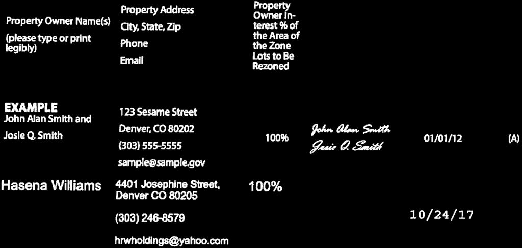
1 Community Planning and Development Planning Services 201 W. Colfax Ave., Dept. 205 Denver, CO p: f: TO: Denver Planning Board FROM: Scott Robinson, Senior City Planner DATE: January 31, 2018 RE: Official Zoning Map Amendment Application #2017I Staff Report and Recommendation Based on the criteria for review in the Denver Zoning Code, Staff recommends approval for Application #2017I Request for Rezoning Address: Neighborhood/Council District: Elyria Swansea / Council District 9 RNOs: United Community Action Network Inc.; Denver Neighborhood Association, Inc.; Cross Community Coalition; Elyria and Swansea Neighborhood Association; Elyria Swansea/Globeville Business Association; Denver Arts and Culture Initiative; Comunidades Unidades Globeville Elyria & Swansea; North Neighborhoods Democratic Council; Inter-Neighborhood Cooperation (INC) Area of Property: 11,000 square feet Current Zoning: E-TU-B Proposed Zoning: U-RH-3A Property Owner(s): HRW Holdings Owner Representative: Hasena Williams Summary of Rezoning Request The property is in the Elyria Swansea neighborhood at the corner of Josephine St. and 44 th Ave. The site is currently vacant. The applicant is requesting the map amendment to construct a small apartment building on the property. The U-RH-3A (Urban Neighborhood, Row House, 3 story, Additional building forms allowed) zone district is intended to promote and protect residential neighborhoods. Generally, the U- RH-3A zone district allows single unit, two unit, multi-unit, and civic/institutional primary uses in primary building forms that include urban house, duplex, tandem house, row house, and apartment in limited situations. At the time this staff report was prepared, the garden court primary building form is subject to a limited moratorium and is proposed to be prohibited in the U-RH-3A zone district in an upcoming text amendment. This site would qualify for the


2 Rezoning Application #2017I January 31, 2018 Page 2 apartment building form because it is located on a corner where one of the intersecting streets is an arterial street. Further details of the zone district can be found in Article 5 of the Denver Zoning Code (DZC).

3 Rezoning Application #2017I January 31, 2018 Page 3 Existing Context The subject property is at the corner of Josephine St. and 44 th Ave., two blocks south of I-70. Josephine St. is one-way northbound and forms a couplet with York St. To the west are industrial uses, including the Purina plant, and to the east are predominantly residential uses. There are a few commercial uses along I-70/46 th Ave. to the north. Swansea Elementary School is just across I-70 to the north and
4 Rezoning Application #2017I January 31, 2018 Page 4 Dunham Park is three blocks to the east. There is RTD bus service on the York St./Josephine St. couplet. The 40 th & Colorado station on the RTD University of Colorado A Line is about three quarters of a mile to the southeast. The following table summarizes the existing context proximate to the subject site: Existing Zoning Existing Land Use Site E-TU-B Vacant Vacant North E-TU-B Residential South E-TU-B Residential East E-TU-B Residential West I-A UO-2 Industrial Existing Building Form/Scale 1-2 story single-unit bungalows 1-story one and two-unit houses 1-2 story single-unit bungalows 1-story industrial/warehouse buildings with taller industrial buildings further west Existing Block, Lot, Street Pattern Generally regular grid of streets, except to the west and south, where it is interrupted by large industrial uses and railroad tracks. Josephine St. and York St. form a one-way couplet. Block sizes and shapes are generally consistent and rectangular. Vehicle parking to the side or rear of buildings (alley access).

5 Rezoning Application #2017I January 31, 2018 Page 5 1. Existing Zoning The current E-TU-B zone district is two-unit residential zoning in the Urban Edge context. It allows up to two units in the urban house, tandem house, or duplex primary building forms on minimum lot sizes of 4,500 square feet. For primary structures, the maximum allowed height is 30 to 35 feet, and setback requirements are three to ten feet on the sides and twelve to twenty feet on the rear. Front setbacks are block sensitive, depending on the setbacks of surrounding structures. There is no parking requirement for single-unit development, and one vehicle parking space per unit is required for two-unit development.

6 Rezoning Application #2017I January 31, 2018 Page 6 2. Existing Land Use Map


7 Rezoning Application #2017I January 31, 2018 Page 7 3. Existing Building Form and Scale Site from 44 th Ave. & Josephine St. North from Josephine St. East from Josephine St. South from 44 th Ave. Source: Google Maps West from 44 th Ave. & York St.
8 Rezoning Application #2017I January 31, 2018 Page 8 Summary of City Agency Referral Comments As part of the DZC review process, the rezoning application is referred to potentially affected city agencies and departments for comment. A summary of agency referral responses follows: Asset Management: Approved No comments. Public Health and Environment: Approved See comments: Notes. The Denver Department of Environmental Health (DEH) concurs with the rezoning request. DEH has information showing the property is located within the boundaries of Operable Unit 1 (OU 1) of the Vasquez Boulevard/I-70 Superfund site which is associated with elevated levels of metals in soil. Under oversight by the U.S. Environmental Protection Agency (EPA), contaminated soils in residential yards were excavated and disposed off-site where necessary, and institutional controls were implemented for the remaining few residential properties where access was not granted. DEH has information to indicate the property at 4401 Josephine St was sampled by EPA and no cleanup was necessary; arsenic and lead in soil were below levels of health concern. Additionally, DEH has information of a past petroleum release from an underground fuel storage tank system near the site. If encountered during construction, contaminated soil, groundwater, or underground storage tanks should be properly managed and disposed in accordance with applicable regulations. General Notes: Most of Colorado is high risk for radon, a naturally occurring radioactive gas. Due to concern for potential radon gas intrusion into buildings, DEH suggests installation of a radon mitigation system in structures planned for human occupation or frequent use. It may be more cost effective to install a radon system during new construction rather than after construction is complete. Denver s Noise Ordinance (Chapter 36 Noise Control, Denver Revised Municipal Code) identifies allowable levels of noise. Properties undergoing Re-Zoning may change the acoustic environment, but must maintain compliance with the Noise Ordinance. Compliance with the Noise Ordinance is based on the status of the receptor property (for example, adjacent Residential receptors), and not the status of the noise-generating property. Violations of the Noise Ordinance commonly result from, but are not limited to, the operation or improper placement of HV/AC units, generators, and loading docks. Construction noise is exempted from the Noise Ordinance during the following hours, 7am 9pm (Mon Fri) and 8am 5pm (Sat & Sun). Variances for nighttime work are allowed, but the variance approval process requires 2 to 3 months. For variance requests or questions related to the Noise Ordinance, please contact Paul Riedesel, Denver Environmental Health ( ). Scope & Limitations: DEH performed a limited search for information known to DEH regarding environmental conditions at the subject site. This review was not intended to conform to ASTM standard practice for Phase I site assessments, nor was it designed to identify all potential environmental conditions. In addition, the review was not intended to assess environmental conditions for any potential right-of-way or easement conveyance process. The City and County of Denver provides no representations or warranties regarding the accuracy, reliability, or completeness of the information provided.
9 Rezoning Application #2017I January 31, 2018 Page 9 Public Works City Surveyor: Approved rezoning only will require additional information at site plan review. The provided legal description is approved and matches the most recent deed in the chain of title. Public Review Process CPD informational notice of receipt of the rezoning application to all affected members of City Council and registered neighborhood organizations: Property legally posted for a period of 15 days and CPD written notice of the Planning Board public hearing sent to all affected members of City Council and registered neighborhood organizations: Date 11/3/17 1/22/18 Planning Board hearing: 2/7/18 CPD written notice of the Land Use, Transportation and Infrastructure Committee meeting sent to all affected members of City Council and registered neighborhood organizations, at least ten working days before the meeting (tentative): Land Use, Transportation and Infrastructure Committee of the City Council meeting (tentative): 2/23/18 3/6/18 Property legally posted for a period of 21 days and CPD written notice of the City Council public hearing sent to all affected members of 3/23/18 City Council and registered neighborhood organizations (tentative): City Council Public Hearing (tentative): 4/16/18 o o Registered Neighborhood Organizations (RNOs) To date, no comments from RNOs have been received. Other Public Comment To date, no other comments have been received.
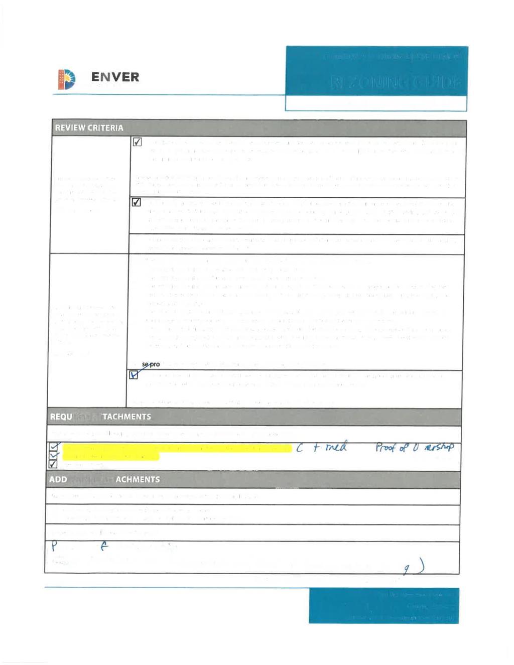
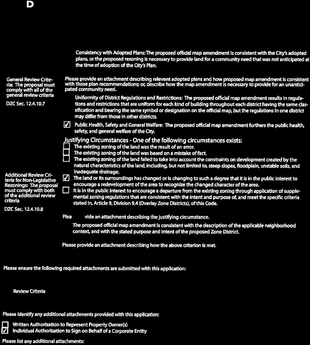
10 Rezoning Application #2017I January 31, 2018 Page 10 Criteria for Review / Staff Evaluation The criteria for review of this rezoning application are found in DZC, Sections and , as follows: DZC Section Consistency with Adopted Plans 2. Uniformity of District Regulations and Restrictions 3. Public Health, Safety and General Welfare DZC Section Justifying Circumstances 2. Consistency with Neighborhood Context Description, Zone District Purpose and Intent Statements 1. Consistency with Adopted Plans The following adopted plans apply to this property: Denver Comprehensive Plan 2000 Blueprint Denver (2002) Elyria & Swansea Neighborhoods Plan (2015) Denver Comprehensive Plan 2000 The proposal is consistent with many Denver Comprehensive Plan strategies, including: Environmental Sustainability Strategy 1-A Encourage redevelopment of vacant, underutilized, and environmentally compromised land known as brownfields. Environmental Sustainability Strategy 2-F Conserve land by promoting infill development within Denver at sites where services and infrastructure are already in place; designing mixed use communities and reducing sprawl so that residents can live, work and play within their own neighborhoods. Land Use Strategy 3-B Encourage quality infill development that is consistent with the character of the surrounding neighborhood; that offers opportunities for increased density and more amenities; and that broadens the variety of compatible uses. Neighborhoods Strategy 1-E Modify land-use regulations to ensure flexibility to accommodate changing demographics and lifestyles. Allow, and in some places encourage, a diverse mix of housing types and affordable units, essential services, recreation, business and employment, home-based businesses, schools, transportation and open space networks. The proposed map amendment would allow higher-density residential development on vacant land that is part of the Vasquez Blvd./I-70 Superfund site where infrastructure is already in place. It would help create a diversity of housing types in the area at an increased density that is compatible with the existing neighborhood, consistent with the recommendations of the Denver Comprehensive Plan. Blueprint Denver According to the Blueprint Denver Plan Map, this site has a concept land use of Single Family Duplex and is located in an Area of Stability.

11 Rezoning Application #2017I January 31, 2018 Page 11 Future Land Use The plan defines Single Family Duplex as moderately dense areas that are primarily residential but with some complementary, small-scale commercial uses. However, the employment base is minor compared to the housing base. There is a mixture of housing types, including single-family houses, duplexes, townhouses, and small apartment buildings. Typical densities are between 10 and 20 housing units per acre area-wide, and single family detached structures often predominate (p. 42). The proposed U-RH-3A zoning would allow single-unit houses, duplexes, rowhouses, or a small apartment building on the subject property. While the density on the property could be greater than 20 units per acre, the area-wide density would not exceed the recommended range with this rezoning. The proposed map amendment is consistent with the Single Family Duplex future land use of Blueprint Denver.
12 Rezoning Application #2017I January 31, 2018 Page 12 Area of Change / Area of Stability Blueprint Denver designates the subject property as in an Area of Stability. According to the plan, the goal for Areas of Stability is to identify and maintain the character of an area while accommodating some new development and redevelopment (p. 120). The proposed U-RH-3A zoning would facilitate development of a vacant parcel at an intensity and scale that is consistent with the character of the neighborhood and would serve as a transition to the adjacent industrial area. Street Classifications Blueprint Denver classifies Josephine St. as an Industrial Arterial and 44 th Ave. as an Undesignated Local. According to Blueprint Denver, Arterials are designed to provide a high degree of mobility and generally serve longer vehicle trips to, from, and within urban areas (p. 51). The plan states industrial streets serve industrial areas. These streets are designed to accommodate a high volume of large vehicles such as trucks, trailers, and other delivery vehicles (p. 58). The proposed U-RH-3A zoning would allow higher-density residential development consistent with the Arterial designation, but the Industrial designation of Josephine St. is inconsistent with the existing land use and the plan s concept land use for the area. Blueprint Denver defines Local streets as those for travel that is typically incidental and involves relatively short trips at lower speeds to and from other streets (p. 51). The proposed U-RH-3A zoning would allow development that would be adequately served by the Local street. Despite the inconsistency with the Industrial street type designation, the proposed map amendment is consistent with the other street classification, concept land use, and area of stability recommendations of Blueprint Denver, and is generally consistent with the plan. Elyria & Swansea Neighborhoods Plan The Elyria & Swansea Neighborhoods Plan was adopted by City Council in 2015 and includes many recommendations for the area. The subject property is designated Single Family Duplex in the concept land use map and is part of the Traditional Residential Area. The plan states Single Family Duplex residential areas are moderately dense areas that are primarily residential. There is a mixture of housing types, including single-family houses, duplexes, rowhouses, and small apartment buildings (p. 26). Traditional Residential Areas are composed of modest single family homes, duplexes and smaller apartment buildings (p. 88). Recommendations for these areas include to accommodate infill development in vacant or underutilized areas (p. 30) and encourage transition of industrial uses embedded in residential areas into lighter flex industrial uses, multi-family residential or mixed uses that better relate to adjacent lower scale residential uses, and that could provide some complementary neighborhood services (p. 89). The plan also recommends to increase the local supply of relatively affordable housing units in the neighborhood. A modest increase in housing density could add more people to the limited neighborhood population and support commercial retail and other desired services in the neighborhood (p. 89).
.")
.")
13 Rezoning Application #2017I January 31, 2018 Page 13 The recommended building height for the subject property is 2.5 stories, and the plan recommends to preserve the low-rise building heights characteristic of the Single Family Duplex character in Elyria and Swansea s Traditional Residential Areas (p. 30). The subject property is in an Area of Stability, which the plan recommends should be considered reinvestment areas where the character is desirable to maintain, but would benefit from reinvestment through modest infill (p. 26). The plan also states the Denver Zoning Code s Urban Neighborhood Context, as opposed to the currently-mapped Urban Edge Context, better reflects the use of alleys, limiting or prohibiting curb cuts for street access, and the continuation of detached sidewalks where possible (p. 88). Elyria & Swansea Neighborhoods Plan Concept Land Use Map The proposed U-RH-3A zoning would allow single-unit houses, duplexes, rowhouses, and small apartment buildings at moderate density, consistent with the plan recommendations. The map amendment would facilitate infill development of a vacant parcel at a higher density than the current zoning allows, potentially increasing the supply of housing in the area and consistent with the Area of Stability recommendations. The proposed U-RH-3A zone district is in the Urban Neighborhood context, as recommended by the plan. The proposed U-RH-3A zoning would allow buildings in the urban house, duplex, and tandem house forms up to 2.5 stories and 30 feet, in the rowhouse form up to 2.5 stories and 35 feet, and in the apartment form up to three stories and 38 feet. The apartment form height would exceed the plan recommendation of 2.5 stories, however there is not a zone district in the Urban Neighborhood context that allows apartments but limits their height to less than three stories, so to achieve the other plan
14 Rezoning Application #2017I January 31, 2018 Page 14 goals of accommodating small apartment buildings and utilizing the Urban Neighborhood context, a slight increase in height is necessary. The allowed height for the three-story apartment form is only three feet greater than the allowed height for the 2.5-story rowhouse form, and by allowing a small increase in height at the subject site it helps achieve the plan goal of providing transitions between industrial and residential areas. Evaluating and balancing all the Elyria & Swansea Neighborhoods Plan goals, the proposed map amendment is consistent with the plan recommendations. 2. Uniformity of District Regulations and Restrictions The proposed rezoning to U-RH-3A would result in the uniform application of zone district building form, use, and design regulations. 3. Public Health, Safety and General Welfare The proposed official map amendment furthers the public health, safety, and general welfare of the City primarily through implementation of the city s adopted land use plan. The proposed rezoning would also facilitate development of a vacant parcel, enhancing safety and improving welfare for the community. 4. Justifying Circumstance The application identifies changed or changing conditions as the Justifying Circumstance under DZC Section A.4, The land or its surrounding environs has changed or is changing to such a degree that it is in the public interest to encourage a redevelopment of the area or to recognize the changed character of the area. The Elyria Swansea neighborhood is seeing significant changes, with the expansion of the National Western Stock Show facility, the introduction of RTD commuter rail, and redevelopment of residential parcels throughout the neighborhood. These changes have increased the need for housing in the area such that it is in the public interest to rezone the subject property to allow additional residential density. 5. Consistency with Neighborhood Context Description, Zone District Purpose and Intent Statements The requested U-RH-3A zone district is within the Urban Neighborhood Context. The neighborhood context generally consists of single-unit and two-unit residential uses with embedded small-scale multiunit residential and commercial areas in a regular block pattern with consistent alleys. (DZC, Division 5.1). As stated above, it is the aspiration of the Elyria Swansea Neighborhoods Plan to develop the area in a manner consistent with the Urban Neighborhood Context. The street and alley pattern is already in place in this location, and the proposed rezoning would allow residential development up to a smallscale multi-unit building, consistent with the context description. The zone district purpose stated in the Denver Zoning Code is to promote and protect residential neighborhoods within the character of the Urban Neighborhood Context, and to allow for some multiunit districts, but not to such an extent as to detract from the overall image and character of the residential neighborhood (DZC Section ). The proposed U-RH-3A zoning would allow
15 Rezoning Application #2017I January 31, 2018 Page 15 development consistent with the desired character for the surrounding residential neighborhood and with the purpose and intent of the zone district. Attachments 1. Application


16 2017I Revised December 8, 2017 $1000 fee pd CC


17 2017I Revised December 8, 2017 $1000 fee pd CC


18 2017I Revised December 8, 2017 $1000 fee pd CC
19 LEGAL DESCRIPTION OF 4401 JOSEPHINE ST Lots 17 through 19, inclusive, and the south ½ of lot 20, block 2, town of Swansea, City and County of Denver, State of Colorado 2017I Revised December 8, 2017 $1000 fee pd CC


20 2017I Revised December 8, 2017 $1000 fee pd CC


21 2017I Revised December 8, 2017 $1000 fee pd CC


22 2017I Revised December 8, 2017 $1000 fee pd CC


23 2017I Revised December 8, 2017 $1000 fee pd CC
24 December 07, 2017 REVIEW CRITERIA Josephine St General Review Criteria: A. Consistency with Adopted Plans The several adopted plans were referenced to provide an analysis of how rezoning the property at 4401 Josephine St. meets the criteria outlined within these plans. The analysis is provided in the narrative below. The following Adopted Plans apply to the property at : Denver Comprehensive Plan (2000) Blueprint Denver (2002) Elyria & Swansea Neighborhood Plan (2015) Comprehensive Plan This rezoning proposal is consistent with many Denver Comprehensive Plan strategies, including: Environmental Strategy: 1A - Encourage redevelopment of vacant, underutilized and environmentally compromised land known as brownfields. (p. 37) Land Use Strategy: 3B - Encourage quality infill development that is consistent with the character of the surrounding neighborhood; that offers opportunities for increased density and more amenities; and that broadens the variety of compatible uses. (p. 60) Housing: 6A - Support mixed-use development consistent with the goals of the Comprehensive Plan s land-use and mobility strategies. (p. 117) 6B - Continue to support mixed-income housing development that includes affordable rental and for-purchase housing for lower-income, entry-level and service employees, especially along transit lines. (p.117) The proposed map amendment will enable development of a vacant property at the corner of E. 44 th and Josephine Street. U-RH-3A zoning designation would support increased density through a building form that is complementary to the existing character of the neighborhood. Further, the location of the property is along an arterial (Josephine Street) which would connect the proposed development to major urban elements such as central business districts, and employment. The rezoning is consistent with the plan recommendations. 2017I Revised December 8, 2017 $1000 fee pd CC
25 Blueprint Denver Area of Stability: Category that is foundational to maintain the character of an area while accommodating some new development and redevelopment. Further, Blueprint Denver suggests reinvestment areas that would benefit from reinvestment through modest infill. The Elyria & Swansea neighborhood is moderately dense and is primarily residential with some complementary, small-scale commercial uses. Within this Area of Stability, Single Family Duplex residential areas are moderately dense areas that are primarily residential. There is a mixture of housing types, including single-family houses, duplexes, townhouses and small apartment buildings. Typically, densities are between 10 and 20 housing units The proposed map amendment will enable development of to U-RH-3A. would fit appropriately in the existing context area, as a small 3-story apartment building. Elyria & Swansea Neighborhood Plan For Elyria and Swansea to be strong neighborhoods in the future, growth and change should occur in Areas of Change while enhancing Areas of Stability, including Traditional Residential Areas. By encouraging strategic growth, the quality of life in the Traditional Residential Areas will be enhanced while promoting a re-imagination of the Areas of Change within Elyria and Swansea. B.3 - INCREASE HOUSING CHOICES: Encourage investment in new housing to expand the total number of residences and to provide for a diversity of housing types to bring more people of all ages and income levels into the neighborhood. E - CHARACTER AREA STRATEGIES: Traditional Residential Areas are embedded within the core of the Elyria and Swansea neighborhoods with heavier industrial uses, rail corridors and highways along the edges. The percentage of home ownership is 48% compared to 50% across Denver. Residents value the intimate quality of the quiet local streets with modest single family homes, duplexes and smaller apartment buildings. These structures range in height from 1 to 2 stories, with garages and small accessory buildings oriented to the alleys. Elyria s traditional residential area has reduced in size over the years due to the construction of I-70 and the expansion of the National Western Stock Show Complex. Although the recommendations in this section are specific to the existing residential areas, this Plan recommends reversing the trend of a declining population and recommends expanding housing throughout the neighborhood, especially near future commuter rail stations. E. 2 - ENCOURAGE INVESTMENT IN RESIDENTIAL AREAS OF STABILITY Recommends Single Family Duplex for residential areas that are intended to remain as Areas of Stability. The following options could provide economic benefit to home owners by allowing a moderate level of infill development, and creating incentive to reinvest in existing homes to further stabilize the residential areas. 2017I Revised December 8, 2017 $1000 fee pd CC
26 Explore opportunities to introduce building forms, consistent with the single family duplex land designation, such as accessory dwelling units, duplex or tandem houses and rowhouses. Ensure that the form and scale of new development is complementary to the existing character of the traditional residential areas. The Elyria & Swansea Neighborhood has a long history of being a diverse and community focused area of metro Denver. The low density mix of residential, multi-family, and small commercial pockets is one of the defining features of the neighborhood and its stability. The proposed map amendment to U-RH- 3A, will enable development of to offer rentals at an affordable price (below market rent, and workforce housing). The Overall Goals for Land Use and Zoning apply directly to our property. They are: 1.To maintain the existing residential integrity of the Swansea Neighborhood, by building an inviting, safe, comfortable low density environment for residents. 2. Reverse the trend of a declining population by offering affordable rentals near mass transit and future commuter rail stations. Consistency with Neighborhood Context, Zone District Purpose and Intent. The Denver Zoning Code provides minimum and maximum zone lot size standards, and building form standards for Single Unit (SU), Two Unit (TU) or Rowhouse (RH) building forms in the Urban Neighborhood context. These building forms are appropriate in Single Family Duplex areas if they are consistent with the maximum building heights map in this plan (Strategy B.7), and the minimum area and building form standards in the Denver Zoning Code General Purpose: A. The intent of the Residential districts is to promote and protect residential neighborhoods within the character of the Urban Neighborhood Context. These regulations allow for some multi-unit districts, but not to such an extent as to detract from the overall image and character of the residential neighborhood. B. The building form standards, design standards, and uses work together to promote desirable residential areas. The standards of the single unit districts accommodate the pattern of one to two and a half story urban house forms where the narrow part of the building orients to the street and access is from alley loaded garages. Lot sizes are consistent within an area and lot coverage is typically medium to high accommodating a consistent front and side yard. There are single unit districts that allow detached accessory dwelling units in the rear yard, maintaining the single unit character at the street. The standards of the two unit and row house districts promote existing and future patterns of lower scale multi unit building forms that address the street in the same manner as an urban house building form. C. These standards recognize common residential characteristics within the Urban Neighborhood Context but accommodate variation by providing eleven Residential Zone Districts. D. The regulations provide certainty to property owners, developers, and neighborhoods about the limits of what is allowed in a residentially-zoned area. These regulations are also intended to 2017I Revised December 8, 2017 $1000 fee pd CC
27 reinforce desired development patterns in existing neighborhoods while accommodating reinvestment. Specific Intent: Row House 3A (U-RH-3A) U-RH-3A is a multi unit district that allows up to a two and a half story rowhouse building form with a maximum overall structure width along the street. Apartments are allowed up to three stories, on certain corner lots. It also allows the urban house, detached accessory dwelling unit, duplex, and tandem house building forms. The proposed map amendment to U-RH-3A of will fit well with the neighborhood context and plan guidance. B. Uniformity of District Regulations and Restrictions The proposed official map amendment results in regulations and restrictions that are uniform for each kind of building throughout each district having the same classification. The Application seeks to rezone the property to U-RH-3A Zone District to build a small apartment building. C. Public Health, Safety, and General Welfare The proposed official map amendment furthers the public health, safety and general welfare of the City. The proposed rezoning poses no health, safety, crime or environmental hazards to the neighborhood. The Application will facilitate providing high-quality, in-demand housing within the same structure as low-intensity, and neighborhood-scale Justifying Circumstance A.The neighborhood surrounding 4401 Josephine St. has changed or is changing to such a degree that is in the public interest to encourage a redevelopment of the area or to recognize the changed character of the area. The proposed rezoning is justified by changing circumstances in the Swansea neighborhood. Due to nearby redevelopment and growth of National Western Complex and I-170, residential housing is starting to diminish. Also, the City as a whole is running out of moderate housing options for middle and low income earners. Our property also lies within major bus routes and an Enhanced Transit Corridor. With bike lanes nearby, proximity to the light rail station and being in the middle of RTD Bus Routes, accessibility to major services and other areas in Denver metro will be very easy. Having alternative modes of transportation will also make this work force housing project more appealing to those on a tight budget and/or limited income. B. The Above Criteria is Met As stated above the proposed official map amendment from E-TU-B to U-RH-3A is consistent with the description of the applicable neighborhood context, and with the stated purpose and intent of the proposed zone district, and would be a great addition to the neighborhood. Thank you for the 2017I Revised December 8, 2017 $1000 fee pd CC
28 opportunity to present this application for rezoning. We are excited about the opportunity to provide a housing option for people who may not necessarily live below the poverty line, and those who are not high enough income earners to live in luxury rentals. We feel there is a tremendous affordable housing shortage and are hoping to do our part to help solve the problem. Sincerely, Hasena Williams HRW Holdings, Inc 2017I Revised December 8, 2017 $1000 fee pd CC
Land Use, Transportation, and Infrastructure Committee of the Denver City Council FROM: Scott Robinson, Senior City Planner DATE: March 22, 2018 RE:
 Community Planning and Development Planning Services 201 W. Colfax Ave., Dept. 205 Denver, CO 80202 p: 720.865.2915 f: 720.865.3052 www.denvergov.org/cpd TO: Land Use, Transportation, and Infrastructure
Land Use, Transportation, and Infrastructure Committee of Denver City Council FROM: Scott Robinson, Senior City Planner DATE: December 6, 2018 RE:
 Community Planning and Development Planning Services 201 W. Colfax Ave., Dept. 205 Denver, CO 80202 p: 720.865.2915 f: 720.865.3052 www.denvergov.org/cpd TO: Land Use, Transportation, and Infrastructure
Staff Report and Recommendation Based on the criteria for review in the Denver Zoning Code, Staff recommends approval for Application #2017I
 TO: Denver Planning Board, Joel Noble, Chair FROM: Theresa Lucero, Senior City Planner DATE: RE: Official Zoning Map Amendment Application #2017I-00163 Staff Report and Recommendation Based on the criteria
Official Zoning Map Amendment Application #2017I Gaylord Street and York Street Rezoning from U-RH-2.5 to U-RX-3 and U-RX-5
 Community Planning and Development Planning Services 201 W. Colfax Ave., Dept. 205 Denver, CO 80202 p: 720.865.2915 f: 720.865.3052 www.denvergov.org/cpd TO: Denver Planning Board FROM: Elizabeth Weigle,
Land Use, Transportation, & Infrastructure Committee of the Denver City Council FROM: Chandler Van Schaack, Senior City Planner DATE: July 3, 2018 RE:
 Community Planning and Development Planning Services TO: Land Use, Transportation, & Infrastructure Committee of the Denver City Council FROM: Chandler Van Schaack, Senior City Planner DATE: July 3, 2018
Denver City Council Land Use, Transportation, and Infrastructure Committee FROM: Courtney Levingston, Senior City Planner DATE: July 26, 2018 RE:
 TO: Denver City Council Land Use, Transportation, and Infrastructure Committee FROM: Courtney Levingston, Senior City Planner DATE: RE: Official Zoning Map Amendment Application #2017I-00151 Staff Report
Official Zoning Map Amendment Application #2018I-00120
 Community Planning and Development Planning Services 201 W. Colfax Ave., Dept. 205 Denver, CO 80202 p: 720.865.2915 f: 720.865.3052 www.denvergov.org/cpd TO: Denver Planning Board FROM: Scott Robinson,
Official Zoning Map Amendment Application #2018I-00067
 Community Planning and Development Planning Services 201 W. Colfax Ave., Dept. 205 Denver, CO 80202 p: 720.865.2915 f: 720.865.3052 www.denvergov.org/cpd TO: Denver Planning Board FROM: Courtney Levingston,
Block bounded by Newton St., 17 th Ave., Lowell Blvd., and 16 th Ave.; plus Meade Street (evens only)
") Community Planning and Development Planning Services 201 W. Colfax Ave., Dept. 205 Denver, CO 80202 p: 720.865.2915 f: 720.865.3052 www.denvergov.org/cpd TO: Denver Planning Board FROM: Sara White, AICP,
Community Planning and Development Planning Services 201 W. Colfax Ave., Dept. 205 Denver, CO 80202 p: 720.865.2915 f: 720.865.3052 www.denvergov.org/cpd TO: Denver Planning Board FROM: Sara White, AICP,
Official Zoning Map Amendment Application #2017I and 4889 South Quebec Street Rezoning from B-4 with waivers, UO-1, UO-2 to C-MX-20
 Community Planning and Development Planning Services 201 W. Colfax Ave., Dept. 205 Denver, CO 80202 p: 720.865.2915 f: 720.865.3052 www.denvergov.org/cpd TO: Denver Planning Board FROM: Jeff Hirt, Senior
Staff Report and Recommendation Based on the criteria for review in the Denver Zoning Code, Staff recommends approval for application #2017I
 TO: Denver City Council, Land Use, Transportation and Infrastructure Committee FROM: Theresa Lucero, Senior City Planner DATE: RE: Official Zoning Map Amendment Application #2017I-00153 Staff Report and
Brad Buchanan, Executive Director, Department of Community Planning and Development
 TO: City Council FROM: Jeff Hirt, Senior City Planner DATE: RE: Official Zoning Map Amendment Application #2017I-00076 3400 Arkins Ct., 3460 Arkins Ct., 1900 35 th St, 1930 35th St., 1950 35 th St Rezoning
Official Zoning Map Amendment Application #2018I-00095
 Community Planning and Development Planning Services 201 W. Colfax Ave., Dept. 205 Denver, CO 80202 p: 720.865.2915 f: 720.865.3052 www.denvergov.org/cpd TO: Denver Planning Board FROM: Ella Stueve, Senior
Based on the criteria for review in the Denver Zoning Code, Staff recommends approval for Application #2018I
 Community Planning and Development Planning Services 201 W. Colfax Ave., Dept. 205 Denver, CO 80202 p: 720.865.2915 f: 720.865.3052 www.denvergov.org/cpd TO: Denver Planning Board FROM: Chandler Van Schaack,
Representative Name. Address. City, State, Zip. Telephone.
 COMMUNITY PLANNING & DEVELOPMENT ~~DENVER... THE MILE HIGH CITY REZONING GUIDE Zone Map Amendment (Rezoning)- Application Rezoning Application Page 1 of 3 Property Owner Name Philip M. Falco Address 730
Request for Rezoning. Current Zoning: Proposed Zoning:
 TO: Denver City Council, Neighborhoods and Planning Committee FROM: Theresa Lucero, Senior City Planner DATE: March 31, 2016 RE: Zoning Map Amendment #2015I-00150 Rezoning from M-RX-5 to I-MX-3 Community
Official Zoning Map Amendment Application #2017I-00090
 Community Planning and Development Planning Services 201 W. Colfax Ave., Dept. 205 Denver, CO 80202 p: 720.865.2915 f: 720.865.3052 www.denvergov.org/cpd TO: Land Use, Transportation, & Infrastructure
Staff Report and Recommendation
 Community Planning and Development Planning Services 201 W. Colfax Ave., Dept. 205 Denver, CO 80202 p: 720.865.2915 f: 720.865.3052 www.denvergov.org/cpd TO: Denver Planning Board FROM: Andrew Webb, Senior
REZONING GUIDE. Zone Map Amendment (Rezoning) - Application. Rezoning Application Page 1 of 3. Return completed form to
 - Application. Rezoning Application Page 1 of 3. Return completed form to") Zone Map Amendment (Rezoning) - Application COMMUNITY PLANNING & DEVELOPMENT REZONING GUIDE Rezoning Application Page 1 of 3 PROPERTY OWNER INFORMATION* CHECK IF POINT OF CONTACT FOR APPLICATION Property
Zone Map Amendment (Rezoning) - Application COMMUNITY PLANNING & DEVELOPMENT REZONING GUIDE Rezoning Application Page 1 of 3 PROPERTY OWNER INFORMATION* CHECK IF POINT OF CONTACT FOR APPLICATION Property
Official Zoning Map Amendment Application #2015I Marion St. Rezoning from U-SU-A1 to U-MX-2x
 Community Planning and Development Planning Services 201 W. Colfax Ave., Dept. 205 Denver, CO 80202 p: 720.865.2915 f: 720.865.3052 www.denvergov.org/cpd TO: Denver City Council FROM: Courtland Hyser,
REZONING GUIDE. Zone Map Amendment (Rezoning) - Application. Rezoning Application Page 1 of 3. Return completed form to
 - Application. Rezoning Application Page 1 of 3. Return completed form to") COMMUNITY PLANNING & DEVELOPMENT REZONING GUIDE Rezoning Application Page 1 of 3 Zone Map Amendment (Rezoning) - Application PROPERTY OWNER INFORMATION* PROPERTY OWNER(S) REPRESENTATIVE** CHECK IF POINT
COMMUNITY PLANNING & DEVELOPMENT REZONING GUIDE Rezoning Application Page 1 of 3 Zone Map Amendment (Rezoning) - Application PROPERTY OWNER INFORMATION* PROPERTY OWNER(S) REPRESENTATIVE** CHECK IF POINT
REZONING GUIDE. Zone Map Amendment (Rezoning) - Application. Rezoning Application Page 1 of 3. Return completed form to
 - Application. Rezoning Application Page 1 of 3. Return completed form to") Zone Map Amendment (Rezoning) - Application COMMUNITY PLANNING & DEVELOPMENT REZONING GUIDE Rezoning Application Page 1 of 3 PROPERTY OWNER INFORMATION* CHECK IF POINT OF CONTACT FOR APPLICATION Property
Zone Map Amendment (Rezoning) - Application COMMUNITY PLANNING & DEVELOPMENT REZONING GUIDE Rezoning Application Page 1 of 3 PROPERTY OWNER INFORMATION* CHECK IF POINT OF CONTACT FOR APPLICATION Property
Public Review of the Slot Home Text Amendment
 Public Review of the Slot Home Text Amendment The proposed amendments to the Denver Zoning Code have been informed by the Slot Home Strategy Report. This document has been developed out of a robust process
Article 3. SUBURBAN (S-) NEIGHBORHOOD CONTEXT
 NEIGHBORHOOD CONTEXT") Article 3. SUBURBAN (S-) NEIGHBORHOOD CONTEXT this page left intentionally blank Contents ARTICLE 3. SUBURBAN (S-) NEIGHBORHOOD CONTEXT DIVISION 3.1 NEIGHBORHOOD CONTEXT DESCRIPTION...3.1-1 Section 3.1.1
Article 3. SUBURBAN (S-) NEIGHBORHOOD CONTEXT this page left intentionally blank Contents ARTICLE 3. SUBURBAN (S-) NEIGHBORHOOD CONTEXT DIVISION 3.1 NEIGHBORHOOD CONTEXT DESCRIPTION...3.1-1 Section 3.1.1
REZONING GUIDE. Zone Map Amendment (Rezoning) - Application. Rezoning Application Page 1 of 3. Return completed form to
 - Application. Rezoning Application Page 1 of 3. Return completed form to") Zone Map Amendment (Rezoning) - Application COMMUNITY PLANNING & DEVELOPMENT REZONING GUIDE Rezoning Application Page 1 of 3 PROPERTY OWNER INFORMATION* CHECK IF POINT OF CONTACT FOR APPLICATION Property
Zone Map Amendment (Rezoning) - Application COMMUNITY PLANNING & DEVELOPMENT REZONING GUIDE Rezoning Application Page 1 of 3 PROPERTY OWNER INFORMATION* CHECK IF POINT OF CONTACT FOR APPLICATION Property
To: S-MX-8 AIO, S-MX-8A AIO, S-MX-12 AIO, C-MX-8 AIO, C-MX-12 AIO, and S-CC-5 AIO
 Community Planning and Development Planning Services 201 W. Colfax Ave., Dept. 205 Denver, CO 80202 p: 720.865.2915 f: 720.865.3052 www.denvergov.org/cpd TO: Denver City Council FROM: Curt Upton, Senior
REZONING GUIDE. Zone Map Amendment (Rezoning) - Application. Rezoning Application Page 1 of 3. Return completed form to
 - Application. Rezoning Application Page 1 of 3. Return completed form to") Zone Map Amendment (Rezoning) - Application COMMUNITY PLANNING & DEVELOPMENT REZONING GUIDE Rezoning Application Page 1 of 3 PROPERTY OWNER INFORMATION* CHECK IF POINT OF CONTACT FOR APPLICATION Property
Zone Map Amendment (Rezoning) - Application COMMUNITY PLANNING & DEVELOPMENT REZONING GUIDE Rezoning Application Page 1 of 3 PROPERTY OWNER INFORMATION* CHECK IF POINT OF CONTACT FOR APPLICATION Property
REZONING GUIDE. Zone Map Amendment (Rezoning) - Application. Applicant: Albus Brooks, Councilman District 9
 - Application. Applicant: Albus Brooks, Councilman District 9") Zone Map Amendment (Rezoning) - Application COMMUNITY PLANNING & DEVELOPMENT REZONING GUIDE Rezoning Application Page 1 of 3 PROPERTY OWNER INFORMATION* CHECK IF POINT OF CONTACT FOR APPLICATION Property
Zone Map Amendment (Rezoning) - Application COMMUNITY PLANNING & DEVELOPMENT REZONING GUIDE Rezoning Application Page 1 of 3 PROPERTY OWNER INFORMATION* CHECK IF POINT OF CONTACT FOR APPLICATION Property
REZONING GUIDE. Zone Map Amendment (Rezoning) - Application. Rezoning Application Page 1 of 3. Return completed form to
 - Application. Rezoning Application Page 1 of 3. Return completed form to") COMMUNITY PLANNING & DEVELOPMENT REZONING GUIDE Rezoning Application Page 1 of 3 Zone Map Amendment (Rezoning) - Application PROPERTY OWNER INFORMATION* PROPERTY OWNER(S) REPRESENTATIVE** CHECK IF POINT
COMMUNITY PLANNING & DEVELOPMENT REZONING GUIDE Rezoning Application Page 1 of 3 Zone Map Amendment (Rezoning) - Application PROPERTY OWNER INFORMATION* PROPERTY OWNER(S) REPRESENTATIVE** CHECK IF POINT
DZC and DRMC Amendments to Implement 38th and Blake Station Area Height Amendments
 DZC and DRMC Amendments to Implement 38th and Blake Station Area Height Amendments DZC Text Amendment #2 to establish River North Design Overlay (DO-7) / 38 th and Blake Incentive Overlay (IO-1) (CB18-0016)
DIVISION 1.3 OFFICIAL ZONING MAP
 Article 1. General Provisions Division 1.3 Official Zone Map DIVISION 1.3 OFFICIAL ZONING MAP SECTION 1.3.1 ADOPTION OF OFFICIAL MAP The digital maps created and maintained by the Department of Community
2017I September 7, 2018 fees waived per
 Review Criteria for 3610 and 3612 North Clay Street from PUD #504 to U-TU-B. 1. Consistency with Adopted Plans: The following adopted plans apply to this property: Denver Comprehensive Plan 2000 Blueprint
Telephone AC / 21,960 SF G-MU-3 G-MX-3
 Zone Map Amendment (Rezoning) - Application PROPERTY OWNER INFORMATION* CHECK IF POINT OF CONTACT FOR APPLICATION Property Owner Name Siddhartha Rathod Address City, State, Zip Telephone Email COMMUNITY
Official Zoning Map Amendment Application #2015I N. King Street and 3441 W. 39 th Ave Rezoning from PUD 406 to U-SU-B1
 Community Planning and Development Planning Services 201 W. Colfax Ave., Dept. 205 Denver, CO 80202 p: 720.865.2915 f: 720.865.3052 www.denvergov.org/cpd TO: Neighborhoods and Planning Committee FROM:
this page left intentionally blank DENVER ZONING CODE
 Article 1. GENERAL PROVISIONS this page left intentionally blank Contents ARTICLE 1. GENERAL PROVISIONS DIVISION 1.1 GENERAL...1.1-1 Section 1.1.1 Purpose...1.1-1 Section 1.1.2 Intent...1.1-1 Section 1.1.3
Missing Middle Housing Types Showcasing examples in Springfield, Oregon
 Missing Middle Housing Types Showcasing examples in Springfield, Oregon MissingMiddleHousing.com is powered by Opticos Design Illustration 2015 Opticos Design, Inc. Missing Middle Housing Study Prepared
REZONING GUIDE. Zone Map Amendment (Rezoning) - Application. Rezoning Application Page 1 of 3. Return completed form to
 - Application. Rezoning Application Page 1 of 3. Return completed form to") Zone Map Amendment (Rezoning) - Application COMMUNITY PLANNING & DEVELOPMENT REZONING GUIDE Rezoning Application Page 1 of 3 PROPERTY OWNER INFORMATION* CHECK IF POINT OF CONTACT FOR APPLICATION Property
Zone Map Amendment (Rezoning) - Application COMMUNITY PLANNING & DEVELOPMENT REZONING GUIDE Rezoning Application Page 1 of 3 PROPERTY OWNER INFORMATION* CHECK IF POINT OF CONTACT FOR APPLICATION Property
AGENDA SLOT HOME EVALUATION & TEXT AMENDMENT. 5:30 - Welcome
 AGENDA 5:30 - Welcome Please sign-in, put a sticker on the map, grab snacks, materials and a seat 5:45 - Staff Presentation 6:15 - Open House Stations Background Information Mixed Use Districts Multi Unit
Operating Standards Attachment to Development Application
 Planning & Development Services 2255 W Berry Ave. Littleton, CO 80120 Phone: 303-795-3748 Mon-Fri: 8am-5pm www.littletongov.org Operating Standards Attachment to Development Application 1 PLANNED DEVELOPMENT
Bylaw No , being "Official Community Plan Bylaw, 2016" Schedule "A" DRAFT
 Bylaw No. 2600-2016, being "Official Community Plan Bylaw, 2016" Schedule "A" Urban Structure + Growth Plan Urban Structure Land use and growth management are among the most powerful policy tools at the
City of Valdosta Land Development Regulations
 Chapter 206 Section 206-1 Base Zoning Districts Standards for Uses, Structures, and Property Development (B) (C) Principal Uses and Structures. Principal uses and structures permitted in each base zoning
Article 6. GENERAL URBAN (G-) NEIGHBORHOOD CONTEXT
 NEIGHBORHOOD CONTEXT") Article 6. GENERAL URBAN (G-) NEIGHBORHOOD CONTEXT this page left intentionally blank Contents ARTICLE 6. GENERAL URBAN (G-) NEIGHBORHOOD CONTEXT DIVISION 6.1 NEIGHBORHOOD CONTEXT DESCRIPTION...6.1-1 Section
Article 6. GENERAL URBAN (G-) NEIGHBORHOOD CONTEXT this page left intentionally blank Contents ARTICLE 6. GENERAL URBAN (G-) NEIGHBORHOOD CONTEXT DIVISION 6.1 NEIGHBORHOOD CONTEXT DESCRIPTION...6.1-1 Section
HOUSING ELEMENT GOALS, OBJECTIVES, AND POLICIES
 HOUSING ELEMENT GOALS, OBJECTIVES, AND POLICIES GOAL 1: To promote the preservation and development of high-quality, balanced, and diverse housing options for persons of all income levels throughout the
E-SU-A. Zone Map Amendment (Rezoning) -Application E-SU-B. Rf tum cornpleted form to rezoning(i:})denvergov.org. *If More Than One Property Owner;
 -Application E-SU-B. Rf tum cornpleted form to rezoning(i:})denvergov.org. *If More Than One Property Owner;") Zone Map Amendment (Rezoning) -Application Property Owner Name Philip M. Falco Representative Name Address 730 17th Street, Suite 900 Address City, State, Zip Denver, CO 80202 City, State, Zip Telephone
Zone Map Amendment (Rezoning) -Application Property Owner Name Philip M. Falco Representative Name Address 730 17th Street, Suite 900 Address City, State, Zip Denver, CO 80202 City, State, Zip Telephone
ARTICLE 3: Zone Districts
 ARTICLE 3: Zone Districts... 3-1 17.3.1: General...3-1 17.3.1.1: Purpose and Intent... 3-1 17.3.2: Districts and Maps...3-1 17.3.2.1: Applicability... 3-1 17.3.2.2: Creation of Districts... 3-1 17.3.2.3:
PLANNING COMMISSION STAFF REPORT
 PLANNING COMMISSION STAFF REPORT REZONING CASE: RZ-15-002 REPORT DATE: January 26, 2016 CASE NAME: Thursday Lunch Club Rezoning PLANNING COMMISSION DATE: February 17, 2016 ADDRESS OF REZONING PROPOSAL:
3.1. OBJECTIVES FOR RESIDENTIAL LAND USE DESIGNATIONS GENERAL OBJECTIVES FOR ALL RESIDENTIAL DESIGNATIONS
 3. RESIDENTIAL LAND USE DESIGNATIONS INTRODUCTION The Residential land use designations provide for housing and other land uses that are integral to, and supportive of, a residential environment. Housing
8.5.1 R1, Single Detached Residential District
 8.5.1 R1, Single Detached Residential District The purpose of this district is to provide for residential development in the form of single detached dwellings. Dwelling, Single Detached Home Business,
PLANNING COMMISSION STAFF REPORT
 PLANNING COMMISSION STAFF REPORT REZONING CASE: RZ-16-001 REPORT DATE: March 8, 2016 CASE NAME: Trailbreak Partners Rezoning PLANNING COMMISSION DATE: March 16, 2016 ADDRESSES OF REZONING PROPOSAL: 5501
Address: 2025 Agassiz Road Applicant: Cristian Anca. RM5 Medium Density Multiple Housing
 REPORT TO COUNCIL Date: February 20, 2017 RIM No. 1250-30 To: From: City Manager Community Planning Department (TB) Application: Z16-0052 Owner: Exceling Investments Inc. No. BC1062096 Address: 2025 Agassiz
Salem HNA and EOA Advisory Committee Meeting #6
 Salem HNA and EOA Advisory Committee Meeting #6 Residential Land Policies Employment Land Policies Policy Discussions with the Committee Outcome of today s meeting Direction from this Committee on proposed
6. RESIDENTIAL ZONE REGULATIONS
 6. RESIDENTIAL ZONE REGULATIONS PART 6A PURPOSE OF CHAPTER (1) The purpose of this Chapter is to provide detailed regulations and requirements that are relevant only to residential zones and specific residential
Midwest City, Oklahoma Zoning Ordinance
 2010 Midwest City, Oklahoma Zoning Ordinance 9/2/2010 Table of Contents Section 1. General Provisions... 5 1.1. Citation... 5 1.2. Authority... 5 1.3. Purpose... 5 1.4. Nature and Application... 5 1.5.
Article Optional Method Requirements
 Article 59-6. Optional Method Requirements [DIV. 6.1. MPDU DEVELOPMENT IN RURAL RESIDENTIAL AND RESIDENTIAL ZONES Sec. 6.1.1. General Requirements... 6 2 Sec. 6.1.2. General Site and Building Type Mix...
PLANNING COMMISSION STAFF REPORT
 PLANNING COMMISSION STAFF REPORT West Capitol Hill Zoning Map Amendment Petition No. PLNPCM2011-00665 Located approximately at 548 W 300 North Street, 543 W 400 North Street, and 375 N 500 West Street
ARTICLE OPTIONAL METHOD REGULATIONS
 ARTICLE 59-6. OPTIONAL METHOD REGULATIONS DIV. 6.1. MPDU DEVELOPMENT IN RURAL RESIDENTIAL AND RESIDENTIAL ZONES SEC. 6.1.1. GENERAL REQUIREMENTS... 6 2 SEC. 6.1.2. GENERAL SITE AND BUILDING T PE MIX...
City Council Land Use, Transportation, and Infrastructure Committee FROM: Jeff Hirt, Senior City Planner DATE: March 9, 2018 RE:
 TO: City Council Land Use, Transportation, and Infrastructure Committee FROM: Jeff Hirt, Senior City Planner DATE: March 9, 2018 RE: Official Zoning Map Amendment #2015I-00168 Community Planning and Development
2018I June 25, 2018 $1000 fee pd chk
 2018I-00050 June 25, 2018 $1000 fee pd chk 2018I-00050 June 25, 2018 $1000 fee pd chk 2018I-00050 June 25, 2018 $1000 fee pd chk 2018I-00050 June 25, 2018 $1000 fee pd chk Legal Description of Property
111 Plunkett Road (formerly part of 135 Plunkett Road) - Zoning By-law Amendment Application and Plan of Subdivision Application - Preliminary Report
 - Zoning By-law Amendment Application and Plan of Subdivision Application - Preliminary Report") STAFF REPORT ACTION REQUIRED 111 Plunkett Road (formerly part of 135 Plunkett Road) - Zoning By-law Amendment Application and Plan of Subdivision Application - Preliminary Report Date: May 27, 2013 To:
STAFF REPORT ACTION REQUIRED 111 Plunkett Road (formerly part of 135 Plunkett Road) - Zoning By-law Amendment Application and Plan of Subdivision Application - Preliminary Report Date: May 27, 2013 To:
City of Spokane Infill Development. June 30, 2016
 City of Spokane Infill Development June 30, 2016 Today s Agenda Introductions Background and Adopted Policy Infill Forms: Facilitated Group Discussion Small-Group Discussions Groups Report Out Next Steps
GENERAL PLAN UPDATE SPECIFIC AREAS OF THE CITY
 GENERAL PLAN UPDATE SPECIFIC AREAS OF THE CITY Background There are a total of 14 specific areas that are being reviewed as part of the update of the General Plan. Requests to review these areas came from
SUBJECT: Application for Planned Unit Development and Rezoning 1725 Winnetka Road
 TO: FROM: CHAIRMAN BILL VASELOPULOS AND MEMBERS OF THE PLAN & ZONING COMMISSION STEVE GUTIERREZ DIRECTOR OF COMMUNITY DEVELOPMENT MEETING DATE: September 5, 2017 SUBJECT: Application for Planned Unit Development
Zoning Code Amendments Completed and Proposed. November 2009 COMPLETED CODE AMENDMENTS. Parking Regulations Effective Sept 28, 2009 Ordinance No.
 Zoning Code Amendments Completed and Proposed COMPLETED CODE AMENDMENTS Amendment/Issue Parking Regulations Effective Sept 28, 2009 Ordinance No. 1454 Residential Density in Planned Developments Effective
Hamilton County Regional Planning Commission
 Hamilton County Regional Planning Commission March 1, 2012 Colerain Township Staff Report Zone Map Amendment: Case No.: ZA2012-01 Joseph Toyota Prepared By: Amy Bancroft, Land Use Planner ACTION REQUESTED:
Community Open House March 8, 2017
 Community Open House March 8, 2017 MEETING OBJECTIVE Provide an overview of the project Gain public insight and feedback on problems associated with slot home development Continue public engagement 03.08.17
CITY OF PORTSMOUTH. CITY COUNCIL POLICY No HOUSING POLICY
 CITY OF PORTSMOUTH CITY COUNCIL POLICY No. 2016-03 HOUSING POLICY WHEREAS, the goals of the City of Portsmouth, as expressed in its 2025 Master Plan, include encouraging walkable mixed-use development,
Outline of Land Use Bylaw, 1P2007 Changes
 Outline of Land Use Bylaw, 1P2007 Changes Changes to single and multi-family builders, renovators, land developers and trades The City s new Land Use Bylaw, 1P2007 has been approved by Council. The new
Paul D. Ralph, BES, RPP, MCIP, Commissioner, Development Services Department
 Public Report To: From: Report Number: Development Services Committee Paul D. Ralph, BES, RPP, MCIP, Commissioner, Development Services Department DS-16-50 Date of Report: April 14, 2016 Date of Meeting:
LITTLE MOUNTAIN ADJACENT AREA REZONING POLICY
 LITTLE MOUNTAIN ADJACENT AREA REZONING POLICY JANUARY 2013 CONTENTS 1.0 INTENT & PRINCIPLES...1 2.0 APPLICATION...2 3.0 HOUSING TYPES, HEIGHT & DENSITY POLICIES...3 3.1 LOW TO MID-RISE APARTMENT POLICIES...4
SECTION 3. Housing. Appendix A LAND USE DEFINITIONS
 SECTION 3 Housing A Appendix A LAND USE DEFINITIONS A-2 Housing Commission Attachment B Appendix A Land Use Definitions INTRODUCTION The Land Use Map (Figure A-1) of Community Vision 2040 illustrates the
Planning Justification Report
 Planning Justification Report 101 Kozlov Street, Barrie, Ont. Destaron Property Management Ltd. November 2015 Revised February 2017 TABLE OF CONTENTS Page 1.0 INTRODUCTION... 1 2.0 DESCRIPTION OF SUBJECT
Introduction. General Development Standards
 Introduction The development standards will set the zoning regulations for the East Park development. This section will illustrate lot standards, approximate open space locations and road standards. The
ARTICLE B ZONING DISTRICTS
 ARTICLE B ZONING DISTRICTS Sec. 8-3021 Established. In order to protect the character of existing neighborhoods; to prevent excessive density of population in areas which are not adequately served with
Missing Middle Housing in Practice
 Missing Middle Housing in Practice Daniel Parolek Principal, Opticos Design, Inc. dan@opticosdesign.com New Partners for Smart Growth Kansas City, MO 2013 1 Bungalow Courts Missing MIddle Housing 2012
2. Rezone a portion of the lot from R2 (Small Lot Residential) to RD2 (Duplex: Housing Lane).
 to RD2 (Duplex: Housing Lane).") Public Notice September 6, 2018 Subject Property Subject Property: 337 Hastings Ave Lot 24, District Lot 1, Group 7, Similkameen Division Yale (Formerly Yale-Lytton) District, Plan 932 Application: The
Public Notice September 6, 2018 Subject Property Subject Property: 337 Hastings Ave Lot 24, District Lot 1, Group 7, Similkameen Division Yale (Formerly Yale-Lytton) District, Plan 932 Application: The
Staff Report PLANNED DEVELOPMENT. Salt Lake City Planning Commission. From: Lauren Parisi, Associate Planner; Date: December 14, 2016
 Staff Report PLANNING DIVISION COMMUNITY & NEIGHBORHOODS To: Salt Lake City Planning Commission From: Lauren Parisi, Associate Planner; 801-535-7932 Date: December 14, 2016 Re: 1611 South 1600 East PLANNED
PIN , Part 1, Plan SR-713 in Lot 2, Concession 5, Township of McKim (1096 Dublin Street, Sudbury)
") STAFF REPORT Applicant: Dalron Construction Limited Location: PIN 02124-0103, Part 1, Plan SR-713 in Lot 2, Concession 5, Township of McKim (1096 Dublin Street, Sudbury) Official Plan and Zoning By-law:
STAFF REPORT Applicant: Dalron Construction Limited Location: PIN 02124-0103, Part 1, Plan SR-713 in Lot 2, Concession 5, Township of McKim (1096 Dublin Street, Sudbury) Official Plan and Zoning By-law:
PUBLIC NOTICE* Studies Requested: Parking analysis. Other Required Permits: Building Permit, Site Development Permit
 C I T Y O F T A C O M A Planning & Development Services Department 747 Market St, Rm 345 Tacoma, WA 98402 PUBLIC NOTICE* Date of Notification: 1/15/2019 Application Received: 12/03/2018 Application Complete:12/07/2018
Appendix A: Guide to Zoning Categories Prince George's County, Maryland
 Appendix A: Guide to Zoning Categories Prince George's County, Maryland RESIDENTIAL ZONES 1 Updated November 2010 R-O-S: Reserved Open Space - Provides for permanent maintenance of certain areas of land
Rapid City Planning Commission
 Rapid City Planning Commission Initial Planned Development Overlay Project Report March 9, 2017 Item #15 Applicant Request(s) Case # 17PD007 Initial Planned Development Overlay to allow a residential development
Planning Justification Report
 Planning Justification Report Kellogg s Lands City of London E&E McLaughlin Ltd. June 14, 2017 Zelinka Priamo Ltd. Page i TABLE OF CONTENTS Page No. 1.0 2.0 2.1 2.2 3.0 4.0 5.0 5.1 5.2 5.3 5.4 5.5 5.6
Chapter 5: Testing the Vision. Where is residential growth most likely to occur in the District? Chapter 5: Testing the Vision
 Chapter 5: Testing the Vision The East Anchorage Vision, and the subsequent strategies and actions set forth by the Plan are not merely conceptual. They are based on critical analyses that considered how
50+54 BELL STREET NORTH
 50+54 BELL STREET NORTH SITE PLAN CONTROL APPLICATION OCTOBER 2014 PREPARED BY: FOTENN Consultants Inc. 223 Mcleod Street Ottawa, ON K2P OZ8 (613) 730-5709 PREPARED FOR: Ottawa Chinese Alliance Church
PART 3 RESIDENTIAL ZONING DISTRICTS. Designation of Residential Zoning Districts and Purpose Statements.
 PART 3 S Section 301. Designation of and Purpose Statements. See Table 3-1 herein this Section for the designations and purpose statements of the respective Residential Zoning Districts which are shown
Planning Rationale in Support of an Application for Plan of Subdivision and Zoning By-Law Amendment
 Planning Rationale in Support of an Application for Plan of Subdivision and Zoning By-Law Amendment The Kilmorie Development 21 Withrow Avenue City of Ottawa Prepared by: Holzman Consultants Inc. Land
8Land Use. The Land Use Plan consists of the following elements:
 8Land Use 1. Introduction The Land Use Plan consists of the following elements: 1. Introduction 2. Existing Conditions 3. Opportunities for Redevelopment 4. Land Use Projections 5. Future Land Use Policies
Director, Community Planning, South District
 STAFF REPORT October 21, 2002 To: Midtown Community Council From: Director, Community Planning, South District Subject: Refusal Report Applications for Amendments to the Official Plan and Zoning By-law,
BROCKVILLE CITY OF BROCKVILLE COMPREHENSIVE ZONING BY-LAW REVIEW DISCUSSION PAPER OCTOBER 2013 FINAL D
 BROCKVILLE CITY OF BROCKVILLE COMPREHENSIVE ZONING REVIEW DISCUSSION PAPER OCTOBER 2013 FINAL D14-13-010 TABLE OF CONTENTS 1. INTRODUCTION... 1 1.1 Purpose and Goals of this Project... 1 1.2 Study Process...
Town of Yucca Valley GENERAL PLAN 1
 Town of Yucca Valley GENERAL PLAN 1 This page intentionally left blank. 3 HOUSING ELEMENT The Housing Element is intended to guide residential development and preservation consistent with the overall values
Cover Letter with Narrative Statement
 Cover Letter with Narrative Statement March 31, 2017 rev July 27, 2017 RE: Rushton Pointe Residential Planned Unit Development Application for Public Hearing for RPUD Rezone PL2015 000 0306 Mr. Eric Johnson,
Better Housing by Design - Proposed Draft Summary
 Better Housing by Design - Proposed Draft Summary How can Portland s multi-dwelling zones be improved to meet the needs of current and future residents? Review the BHD Proposed Draft for potential solutions,
Chapter 1107: Zoning Districts
 Chapter 1107: Zoning Districts 1107.01 Establishment of Zoning Districts (a) Districts Established In order to carry out the purpose of this code, the City is hereby divided into the zoning districts established
1417, , 1427 & 1429 Yonge Street - Official Plan Amendment and Zoning Amendment Applications - Preliminary Report
 STAFF REPORT ACTION REQUIRED 1417, 1421-1425, 1427 & 1429 Yonge Street - Official Plan Amendment and Zoning Amendment Applications - Preliminary Report Date: March 24, 2015 To: From: Wards: Reference Number:
Planning Department Oconee County, Georgia
 Planning Department Oconee County, Georgia STAFF REPORT REZONE CASE #: 6985 DATE: October 31, 2016 STAFF REPORT BY: Andrew C. Stern, Planner APPLICANT NAME: Williams & Associates, Land Planners PC PROPERTY
SUBDIVISION DESIGN PRINCIPLES AND STANDARDS
 SECTION 15-200 SUBDIVISION DESIGN PRINCIPLES AND STANDARDS 15-201 STREET DESIGN PRINCIPLES 15-201.01 Streets shall generally conform to the collector and major street plan adopted by the Planning Commission
13 Sectional Map Amendment
 13 Sectional Map Amendment Introduction This chapter reviews land use and zoning policies and practices in Prince George s County and presents the proposed zoning in the sectional map amendment (SMA) to
GNV RISE Subdivision. GNV RISE Subdivision
 GNV RISE Subdivision GNV RISE Subdivision A. Purpose and intent. 1. The purpose of this section is to provide a framework of adaptable incentive-based subdivision design standards which are intended to
25 Leonard Avenue - Official Plan Amendment and Zoning Amendment Applications - Preliminary Report
 STAFF REPORT ACTION REQUIRED 25 Leonard Avenue - Official Plan Amendment and Zoning Amendment Applications - Preliminary Report Date: March 8, 2017 To: From: Wards: Reference Number: Toronto and East York
United States Post Office and Multi-Family Residential; and, Single- Family Residence with an Apartment
 Planning Commission File No.: AME2013 0009 January 9, 2014 Page 2 of 9 Existing Land Use: United States Post Office and Multi-Family Residential; and, Single- Family Residence with an Apartment Surrounding
STAFF REPORT FOR MAJOR SUBDIVISION
 STAFF REPORT FOR MAJOR SUBDIVISION FINAL PLAT CASE NO. FA-14-001 HEARING DATE: January 6, 2016 CASE NAME: Solterra Subdivision Filing No. 16 PROCEDURE: Planning Commission ADDRESS OF MAJOR SUBDIVISION