REZONING GUIDE. Zone Map Amendment (Rezoning) - Application. Rezoning Application Page 1 of 3. Return completed form to
|
|
|
- Lionel Lambert
- 5 years ago
- Views:
Transcription


1 COMMUNITY PLANNING & DEVELOPMENT REZONING GUIDE Rezoning Application Page 1 of 3 Zone Map Amendment (Rezoning) - Application PROPERTY OWNER INFORMATION* PROPERTY OWNER(S) REPRESENTATIVE** CHECK IF POINT OF CONTACT FOR APPLICATION CHECK IF POINT OF CONTACT FOR APPLICATION Property Owner Name Multiple Owners - See Pages 3A & 3B Representative Name Starboard Realty Group, Bruce O'Donnell Address Sheridan Blvd. Address 770 Sherman Street, Suite 108 City, State, Zip Denver, CO City, State, Zip Denver, CO Telephone Telephone bodonnell@starboardrealtygroup.com bodonnell@starboardrealtygroup.com *If More Than One Property Owner: **Property owner shall provide a written letter authorizing the representative to act on his/her behalf. All standard zone map amendment applications shall be initiated by all the owners of at least 51% of the total area of the zone lots subject to the rezoning application, or their representatives authorized in writing to do so. See page 3. Please attach Proof of Ownership acceptable to the Manager for each property owner signing the application, such as (a) Assessor s Record, (b) Warranty deed or deed of trust, or (c) Title policy or commitment dated no earlier than 60 days prior to application date. SUBJECT PROPERTY INFORMATION Location (address and/or boundary description): 1602, 1620, 1634, 1640, 1650 & 1680 Sheridan Blvd. Assessor s Parcel Numbers: See Exhibit A Area in Acres or Square Feet: 77,400 Square Feet Current Zone District(s): U-SU-C2 & U-RH-3A PROPOSAL Proposed Zone District: G-MS-5 Does the proposal comply with the minimum area requirements specified in DZC Sec : Last updated: February 4, 2015 Yes No Return completed form to rezoning@denvergov.org 201 W. Colfax Ave., Dept. 205 Denver, CO rezoning@denvergov.org
2 COMMUNITY PLANNING & DEVELOPMENT REZONING GUIDE Rezoning Application Page 2 of 3 REVIEW CRITERIA General Review Criteria: The proposal must comply with all of the general review criteria DZC Sec Consistency with Adopted Plans: The proposed official map amendment is consistent with the City s adopted plans, or the proposed rezoning is necessary to provide land for a community need that was not anticipated at the time of adoption of the City s Plan. Please provide an attachment describing relevant adopted plans and how proposed map amendment is consistent with those plan recommendations; or, describe how the map amendment is necessary to provide for an unanticipated community need. Uniformity of District Regulations and Restrictions: The proposed official map amendment results in regulations and restrictions that are uniform for each kind of building throughout each district having the same classification and bearing the same symbol or designation on the official map, but the regulations in one district may differ from those in other districts. Public Health, Safety and General Welfare: The proposed official map amendment furthers the public health, safety, and general welfare of the City. Justifying Circumstances - One of the following circumstances exists: Additional Review Criteria for Non-Legislative Rezonings: The proposal must comply with both of the additional review criteria The existing zoning of the land was the result of an error. The existing zoning of the land was based on a mistake of fact. The existing zoning of the land failed to take into account the constraints on development created by the natural characteristics of the land, including, but not limited to, steep slopes, floodplain, unstable soils, and inadequate drainage. The land or its surroundings has changed or is changing to such a degree that it is in the public interest to encourage a redevelopment of the area to recognize the changed character of the area. It is in the public interest to encourage a departure from the existing zoning through application of supplemental zoning regulations that are consistent with the intent and purpose of, and meet the specific criteria stated in, Article 9, Division 9.4 (Overlay Zone Districts), of this Code. DZC Sec Please provide an attachment describing the justifying circumstance. The proposed official map amendment is consistent with the description of the applicable neighborhood context, and with the stated purpose and intent of the proposed Zone District. Please provide an attachment describing how the above criterion is met. REQUIRED ATTACHMENTS Please ensure the following required attachments are submitted with this application: Legal Description (required to be attached in Microsoft Word document format) Proof of Ownership Document(s) Review Criteria ADDITIONAL ATTACHMENTS Please identify any additional attachments provided with this application: Written Authorization to Represent Property Owner(s) Please list any additional attachments: Please see attachments A-E Last updated: February 4, 2015 Return completed form to rezoning@denvergov.org 201 W. Colfax Ave., Dept. 205 Denver, CO rezoning@denvergov.org


3 PAGE 3A Rezoning Application Page 3 of 3 1;,1:<e!_:.l:l:IAf[_!11&,.l.'1:I: I 11;,1:<tJ:.l:l:IJVlll"' -'l:l:u.,1!..l: ::s.,::1, r 11!_'"1( ::1 ll l:lr r11,,n We, the undersigned represent that we are the owners of the property described opposite our names, or have the authorization to sign on behalf of the owner as evidenced by a Power of Attorney or other authorization attached, and that we do hereby request initiation of this application. I hereby certify that, to the best of my knowledge and belief, all information supplied with this application is true and accurate. I understand that without such owner consent, the requested official map amendment action cannot lawfully be accomplished. Property Address Property Owner Name(s) City, State, Zip (please type or print Phone legibly) EXAMPLE John Alan Smith and Josie Q. Smith Property Owner Interest% of the Area of the Zone Lots to Be Rezoned David J. Weber Date Property owner representative written authorization? (YES/NO) (A) NO 123 Sesame Street Denver, CO (303) % sample@sample.gov Cory J. Manders Please sign below as an indication of your consent to the above certification statement (must sign in the exact same manner as title to the property is held) Indicate the type of ownership documentation provided: (A) Assessor's record, (B) warranty deed or deed of trust, (C) title policy or commitment, or (D) other as approved 1634 Sheridan Blvd. 7.75% Denver, CO cory.j.manders@sherwin.c om 1640 Sheridan Blvd. Denver, CO dlbew@yahoo.com 7.75% p.o1-at-.. jl.&iutl.&u:t-1 01/01/12 II I J..6/ 17 YES A 'fr-5 A \ < / - II /:20}!7 \ David Weber Ricky E. Lang 1650 Sheridan Blvd. Denver, CO dlbew@yahoo.com, 15.5% 1680 Sheridan Blvd. Denver, CO relang@raytheon.com 31.78% ( ijk 11pe>)7 A (# ( 1jo/;7 A fcs A Last updated: February 4, 2015 Return completed form to rezoning@denvergov.org 201 W. Colfax Ave., Dept. 205 Denver CO 80202
4 PAGE 3B 24.81% 12.4% see below see below 1/10/18 yes 1/10/18 yes
5 List of Exhibits Exhibit A: Property Assessor s Parcel Numbers and Legal Description Exhibit B: Description of Consistency with Adopted City Plans (DRMC (A, B & C)) Exhibit C: Description of Justifying Circumstances and Neighborhood Context (DRMC (A&B)) Exhibit D: Letters of Authorization for STARBOARD Realty Group, LLC to act as Representative Exhibit E: Proof of Ownership, Assessors Record Exhibit F: Signature Authority Authorization
6 Exhibit A Assessor s Parcel Numbers & Legal Descriptions ADDRESS ASSESSOR PARCEL # LEGAL DESCRIPTION 1602 Sheridan THE SOUTH 150 FEET OF THE WEST 128 FEET OF THE RESUBDIVISION, BRINKHAUS SLOAN LAKE ADDITION 1620 Sheridan THE NORTH 75 FEET OF THE WEST 128 FEET OF RESUBDIVISION, BRINKHAUS SLOAN LAKE ADDITION 1634 Sheridan BRINKHAUS' SLOAN LAKE ADDITION 2ND FILING BLOCK 3 LOTS 15 & Sheridan BRINKHAUS' SLOAN LAKE ADDITION 2ND FILING BLOCK 3 LOTS 13 & Sheridan BRINKHAUS' SLOAN LAKE ADDITION 2ND FILING BLOCK 3 LOTS 9 TO Sheridan BRINKHAUS' SLOAN LAKE ADDITION 2ND FILING BLOCK 3 LOTS 1 TO 8
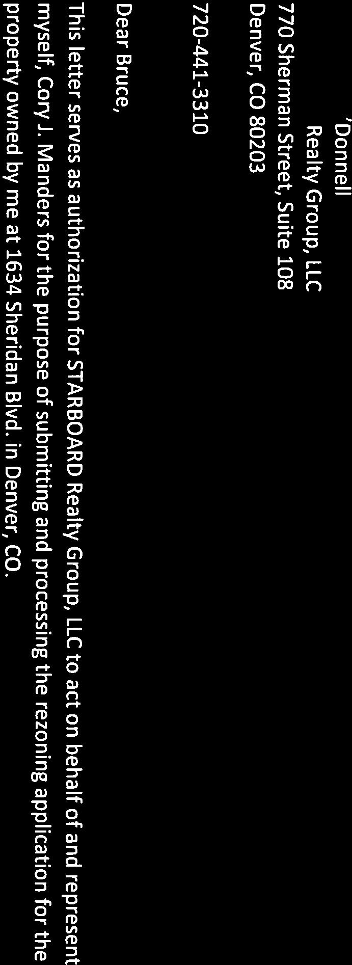
7 EXHIBIT D Letters of Authorization for STARBOARD Realty Group, LLC to act as Representative
8 ÿ !" 8 #0$ 6 %68&'#

9

10


11


12
13 EXHIBIT E Proof of Ownership, Assessors Record
14 ÿ789 *+, ÿ789 ÿ ÿ ÿ ÿ F 9 G 9 ÿh I7H F 9 G78 J ÿh I7H 0534ÿ$9 Kÿ7H 9 9 ÿgÿljÿ2434 M0 04 / ÿ N0N ÿÿ 9-:;4ÿ<-=0.>?@>A, 7ÿ0 4ÿOHÿJOÿH89ÿPÿ032ÿOHÿJOÿH89ÿ97I ÿ7h$ÿ F8 I7ÿ7 J ÿ F9ÿ B.A?-.@CÿDC?- QÿRJ 9 ÿ L Hÿ ÿmÿs97t D;Eÿ<>=@.>0@ 9 $!#! %ÿ U!V V# /@C4-W JH89 X-2.AA7=W X3>42>,:ÿ/Y.Zÿ[AA@W 4 X;@1=ÿ[344\];4^W 414 _^^-0@>`-ÿa-;.ÿX3>4@W 4444 X;=-7-,@\[>,>=1W 414 9A@ÿ/>b-W 0 G344 ca,-2ÿd=w IM8MN 6A@-Wÿ &' (& V# ÿe# V "ÿ)&%ÿf ÿ Vgg! ÿg!#)ÿlv %h ÿ ÿe# V "ÿu# L(!! ÿk &! d0@3;4 d==-==-2 _E-7?@ & in2ngn44 i000g054 )!# ) i4 i4 H# &' in2ngn44 i000g054 i4 $!V#!ÿK &! d0@3;4 d==-==-2 _E-7?@ & i02 G444 i0 G5 4 )!# ) i4 i4 H# &' i02 G444 i0 G5 4 i4 j-;4ÿ_=@;@-=ÿb.a?-.@cÿd;e-=ÿ^a.ÿ03..-,@ÿ@;eÿc-;. $' & ÿu'vukÿ# ÿ& V V# &'ÿv g#!)& V# ÿf '# ÿ #ÿu Ukÿg#!ÿ& %ÿ 'V l( UV ÿ# ÿ V ÿ!#! %1 U (' ÿ ()f!ÿ& ÿg#!ÿ &mÿ &' ÿv g#!)& V# n,=@;447-,@ÿoÿ n,=@;447-,@ÿqÿÿ [344ÿB;C7-,@ÿÿ p[-8ÿqrÿÿ ps3,ÿotu p<3-ÿd?.ÿvwu 11!"# #!"1$!#! %1! &'!#! %1 ())&!%
15 ÿ789 ()*+, ÿ 0534ÿ789 ÿ ÿ ÿ D 9 E 9 ÿf G7F D 9 E78 H ÿf G7F 0534ÿ"9 Iÿ7F 9 9 ÿeÿjhÿ2434kl0k04 -./+012+ÿ4156+, 43M0M ÿÿ 7+892ÿ:+;.,<=><?* ÿnopfÿhpÿqÿ032pfÿhpÿ97 ÿ7f" D8 G7ÿ7 H ÿ 97 9 F B9Cÿ:<;>,<.> 9 "! #ÿ R S S! ->A2+T H 9L7FH I U1<20<*8ÿ-V,WÿX??>T N24 U+0,??5;T 3 U9>/;ÿX122YZ92[T 314 \[[+.><]+ÿ^+9,ÿu1<2>t 0 K4 U9;+5+*>YX<*<;/T N241N44 7?>ÿ-<_+T E544 `?*+0ÿa;T GL8LM 4?>+Tÿ $% &$ S! ÿb! S ÿ'$#ÿc ÿ Sdd ÿd!'ÿjs #e ÿ ÿb! S ÿr! J& ÿi $ a.>192 a;;+;;+0 \C+5=> $ f0n3e344 f03ek44 '! ' f0k4e 44 f04e0o4 F! $% fm0me044 f33eoo4 a.>192 a;;+;;+0 \C+5=> $ f0n3e344 f0men04 '! ' f55e 44 foemm4 F! $% f3m E044 f0 E4K4 f4 " S! ÿi $ f4 g+92ÿ\;>9>+;ÿ@,?=+,>aÿb9c+;ÿ[?,ÿ.1,,+*>ÿ>9cÿa+9, "% $ ÿr%srhÿ! ÿ$ S S! $%ÿs d! '$ S! ÿc %! ÿ!ÿr Rhÿd! ÿ$ #ÿ %S i& RS ÿ! ÿ S ÿ! #1 R &% ÿ &'c ÿ$ ÿd! ÿ $jÿ $% ÿs d! '$ S! k*;>9225+*>ÿlÿ k*;>9225+*>ÿnÿÿ X122ÿ@9A5+*>ÿÿ mx+6ÿnoÿÿ mp1*ÿlqr m:1+ÿa=,ÿstr 11!! 1"! #1 $%! #1 &''$ #
16 11/16/ SHERIDAN BLVD SHERIDAN BLVD Owner MANDERS,CORY J 98 WADSWORTH BLVD 127 LAKEWOOD, CO Schedule Number Legal Description BRINKHAUS' SLOAN LAKE ADD 2ND FLG B3 L15 & 16 Property Type RESIDENTIAL Tax District DENV Property Description Style: ONE-STORY Building Sqr. Foot: 828 Bedrooms: 2 Baths Full/Half: 1/0 Effective Year Built: 1925 Basement/Finish: 378/0 Lot Size: 6,000 Zoned As: U-RH-3A Note: Valuation zoning may be different from City's new zoning code. Current Year Actual Assessed Exempt Land $119,600 $8,610 Improvements $178,400 $12,850 Total $298,000 $21,460 Land $119,600 $9,520 Improvements $100,200 $7,980 Total $219,800 $17,500 $0 Prior Year Actual Assessed Exempt $0 Real Estates Property Taxes for current tax year Please click on additional information below to check for any delinquencies on this property/schedule number and for tax sale information. Installment 1 (Feb 28 Installment 2 (Jun 15) Full Payment (Due Apr 30) 1/2
17 11/16/ SHERIDAN BLVD SHERIDAN BLVD Owner WEBER,DAVID J 1640 SHERIDAN BLVD LAKEWOOD, CO Schedule Number Legal Description BRINKHAUS' SLOAN LAKE ADD 2ND FLG B3 L13 & 14 Property Type RESIDENTIAL DUPLEX Tax District DENV Property Description Style: OTHER Bedrooms: Building Sqr. Foot: 1713 Baths Full/Half: 0/0 Effective Year Built: 1954 Basement/Finish: 0/0 Lot Size: 6,000 Zoned As: U-RH-3A Note: Valuation zoning may be different from City's new zoning code. Current Year Actual Assessed Exempt Land $149,500 $10,760 Improvements $229,600 $16,530 Total $379,100 $27,290 Land $71,800 $5,720 Improvements $142,800 $11,370 Total $214,600 $17,090 $0 Prior Year Actual Assessed Exempt $0 Real Estates Property Taxes for current tax year Please click on additional information below to check for any delinquencies on this property/schedule number and for tax sale information. Installment 1 (Feb 28 Installment 2 (Jun 15) Full Payment (Due Apr 30) 1/2
18 11/16/ SHERIDAN BLVD SHERIDAN BLVD Owner WEBER,DAVID 3034 W 24TH AVE DENVER, CO Schedule Number Legal Description BRINKHAUS' SLOAN LAKE ADD 2ND FLG B3 L9 TO 12 Property Type RESIDENTIAL Tax District DENV Property Description Style: ONE-STORY Building Sqr. Foot: 1090 Bedrooms: 3 Baths Full/Half: 1/0 Effective Year Built: 1941 Basement/Finish: 0/0 Lot Size: 12,000 Zoned As: U-SU-C2 Note: Valuation zoning may be different from City's new zoning code. Current Year Actual Assessed Exempt Land $154,400 $11,120 Improvements $70,300 $5,060 Total $224,700 $16,180 Land $102,900 $8,190 Improvements $55,500 $4,420 Total $158,400 $12,610 $0 Prior Year Actual Assessed Exempt $0 Real Estates Property Taxes for current tax year Please click on additional information below to check for any delinquencies on this property/schedule number and for tax sale information. Installment 1 (Feb 28 Installment 2 (Jun 15) Full Payment (Due Apr 30) 1/2
19 11/16/ SHERIDAN BLVD SHERIDAN BLVD Owner LANG,RICKY E 1680 SHERIDAN BLVD DENVER, CO Schedule Number Legal Description BRINKHAUS' SLOAN LAKE ADD 2ND FLG B3 L1 TO 8 Property Type RESIDENTIAL Tax District DENV Property Description Style: ONE-STORY Building Sqr. Foot: 2621 Bedrooms: 3 Baths Full/Half: 2/1 Effective Year Built: 1954 Basement/Finish: 0/0 Lot Size: 24,600 Zoned As: U-SU-C2 Note: Valuation zoning may be different from City's new zoning code. Current Year Actual Assessed Exempt Land $286,700 $20,640 Improvements $60,800 $4,380 Total $347,500 $25,020 Land $191,100 $15,210 Improvements $29,400 $2,340 Total $220,500 $17,550 $0 Prior Year Actual Assessed Exempt $0 Real Estates Property Taxes for current tax year Please click on additional information below to check for any delinquencies on this property/schedule number and for tax sale information. Installment 1 (Feb 28 Installment 2 (Jun 15) Full Payment (Due Apr 30) 1/2
20 Exhibit F Signature Authority Authorization
21
22
23 EXHIBIT B Description of Consistency with Adopted City Plans REVIEW CRITERIA - The proposed map amendment is consistent with the following three adopted plans: Denver Comprehensive Plan 2000 Blueprint Denver (2002) West Colfax Plan (2006) Statement of Consistency with Adopted City Plans: 1. The proposed map amendment is consistent with many objectives of Denver Comprehensive Plan 2000 including: From Land Use Strategy 3-B: Encourage quality infill development that is consistent with the character of the surrounding neighborhood; that offers opportunities for increased density and more amenities; and that broadens the variety of compatible uses. Mobility Strategy 4-E: Continue to promote mixed-use development, which enables people to live near work, retail and services. Legacies Strategy 3-A: Identify areas in which increased density and new uses are desirable and can be accommodated. The proposed map amendment will also contribute to preserving and enhance the individuality, diversity and livability of Denver s neighborhoods by fostering the following Plan objectives: Congruency of land use and zoning: a built environment with greater overall urban design integrity, stronger connections among urban centers, and a richer and more diverse mix of uses within geographically proximate areas. Compact development: improved neighborhood cohesion, reduced urban sprawl and residents more directly connected to services and amenities within their immediate living environment. 2. The proposed map amendment is consistent with many objectives of Blueprint Denver including:
24 The Blueprint Denver future land use designation for the subject property is Mixed Use. While the Property is located in an Area of Stability, the proposed map amendment is still consistent with many of Blueprint Denver s stated goals. Blueprint Denver describes Mixed Use neighborhoods that consist primarily of residential land uses and states that There are several different types of residential areas and neighborhoods often have more than one type of land use within them. And: A city should contain neighborhoods that offer a variety of housing types, as well as complementary land-use types such as stores, parks and schools that provide the basic needs of nearby residents. Blueprint Denver also states Areas of Stability represent the majority of Denver s residential areas where there is a prevailing character that should be preserved or enhanced through reinvestment and describes areas that demonstrate stability through a high home occupancy rate, yet are threatened by inadequate or deteriorating infrastructure, land-use conflicts such as those between industrial and residential uses or a lack of basic services such as grocery stores. These areas need stabilization through reinvestment. Blueprint Denver asserts: the goal for the Areas of Stability is to identify and maintain the character of an area while accommodating some new development and redevelopment. The map amendment proposed in this application does just that with the proposed zoning it allows for the maintenance of the character of the area while providing redevelopment along a major arterial to be consistent with the land use concept for the property (mixed use) found in Blueprint Denver. The Property also provides opportunities for the following Blueprint Denver Strategies including: Infill and redevelop vacant and underused properties Compatibility between new and existing development Balanced mix of uses New G-MS-5 zoning for the Property will allow these Blueprint Denver goals to be implemented. Blueprint Denver also is relevant to the Property and positively informs the rezoning request as the Land Use Concept envisioned for the Property by Blueprint Denver is Mixed Use and Sheridan Blvd in this location has a Future Street Classification of Mixed Use Arterial. Blueprint Denver provides as follows: Mixed-Use Zoning: Mixed-use zoning provides a mixture of uses to enable residents to shop and work in the same area. Mixed-use zoning allows or encourages residential use with commercial use, such as moderate sized offices or retail. The uses can be either mixed in the same building or in separate buildings near each other.


25 Either new G-MS-5 zoning for the Property will allow this Blueprint Denver goal to be implemented. 3. The proposed map amendment is consistent with many objectives of the West Colfax Neighborhood Plan including: Recommendation 3: Application of Main Street Regulatory Tools Rezone the commercial properties and opportunity sites along West Colfax Avenue, Federal Boulevard and Sheridan Within the Main Street District Goals the West Colfax Boulevard to Main Street. Neighborhood Plan provides the following support for this map amendment through its stated goals as follows: Goal 2: Orientation of Mixed-Use Development. Encourage mixed-use development with the greatest intensity focused to the corridor and especially near major transit stops. The proposed map amendment to G-MS-5 will facilitate the goal of mixed-use intensity focused around the Sheridan corridor. Further, the Property is located in a main street district known as the Pig N Whistle District. One of the Main Street District recommendations for the Pig N Whistle District is deeper parcels, the presence of more intense residential structure and the proximity to rich supply of transit make this an appropriate place for the application of Main Street 2 (which permits structures up to 65 tall. The proposed map amendment to G-MS-5 embrace this concept of more intense residential structures. The Urban Design Concept Map proposed by the West Colfax Neighborhood plan shows the Property as a Main Street Mixed Use Area. This designation fits the proposed map amendment for G-MS-5 and provides further plan support for this application.
26 EXHIBIT C Description of Justifying Circumstances and Neighborhood Context Justifying Circumstances - One of the following circumstances exists: 1. The land or its surroundings has changed or is changing to such a degree that it is in the public interest to encourage a redevelopment of the area to recognize the changed character of the area. 2. The proposed official map amendment is consistent with the description of the applicable neighborhood context, and with the stated purpose and intent of the proposed Zone District. Statement of Justifying Circumstances: The approximately 1.8 acre Property to be rezoned to G-MS-5 is located in a part of Denver undergoing tremendous and positive transformation. The West Colfax community is developing rapidly and property values are rising. The proposed map amendment is in response to these changing conditions and the need for density and mixed development along mixed-use arterials. The Property consists of under developed land that is efficiently served by existing infrastructure. Rezoning will further the policy goals and multiple City plans directing conversion of the Property to a vibrant mixed-use or main street area. This rezoning will be an implementation step of the policy, land use and transportation goals identified in the aforementioned Plans. Once rezoned, the Property can accommodate the urban densities and mix of uses prescribed in the plans. This rezoning is necessary for the following reasons: 1. Conformance with the West Colfax Plan. 2. The ability to increase connectivity along Sheridan Boulevard. 3. Improves the transition from residential to mixed use development in the West Colfax neighborhood. 4. Further implementation of Blueprint Denver. Development throughout the West Colfax Neighborhood over the last 10 years has transformed the area into a premier mixed use urban infill community. The proposed Zone Districts offered by the applicant provide the form-based context to enable what the market, the community and Denver s elected officials desire for the furtherance of the neighborhood. Design elements imbedded in the zoning such as building height and orientation will help create a quality community the City and its residents will be proud of.
27 Statement of Consistency with Neighborhood Context and General Purpose of Zone Districts: This map amendment application requests approval of the G-MS-5 Zone District for the Property. The G Zone Districts are appropriate as they are intended for use in General Urban such as the West Colfax neighborhood. The Denver Zoning Code states that the General Purpose of the G Zone - Mixed Use Zone Districts is intended to promote safe, active, and pedestrian-scaled, diverse areas through the use of single-unit, two-unit, and multi-unit residential building forms. This may include commercial uses within the same structure that may contain a mixture of uses. Commercial uses are primarily located on mixed-use arterial and main streets to clearly define and activate the public street edge. The Mixed Use Zone Districts are intended to enhance the convenience, ease and enjoyment of transit, walking, shopping and public gathering within and around the city s neighborhoods. The Mixed Use Zone District standards are also intended to ensure new development contributes positively to established residential neighborhoods and character, and improves the transition between commercial development and adjacent residential neighborhoods. The Denver Zoning Code states that the Main Street Zone Districts are intended to enhance the convenience, ease and enjoyment of transit, walking, shopping and public gathering along the city s commercial streets. The Main Street district standards are also intended to ensure new development contributes positively to established residential neighborhoods and character, and improves the transition between commercial development and adjacent residential neighborhoods. G-MS-5 is an general urban mixed-use district intended to promote development and redevelopment of urban neighborhoods with building up to 5 stories high. Mixed Use districts are focused on creating mixed, diverse neighborhoods. The proposed use contemplated by the applicant will create and enhance a mixed, diverse neighborhood with improved connectivity between the residential and commercial. The General Intent for this rezoning to G-MS-5 is as follows: 1. To Implement the Denver Comprehensive Plan and its supplements. 2. To implement both Blueprint Denver as well as the West Colfax Neighborhood Plan. 3. Encourage both horizontal and vertical mixed-use development as well as minimizing new development with extremely low site coverage ratios and discourage low density, single use development with excessive parking. 4. The Mixed Use Zone Districts are intended to promote safe, active, and pedestrianscaled, diverse areas through the use of town house, row house, apartment, and shopfront building forms that clearly define and activate the public street edge. 5. The Mixed Use Zone Districts are intended to enhance the convenience, ease and enjoyment of transit, walking, shopping and public gathering within and around the city s neighborhoods.
28 REVIEW CRITERION-The proposed official map amendment furthers the public health, safety, and general welfare of the City. The proposed map amendment will further the public health, safety, and general welfare of the City by facilitating the improvement and development of the Property as desired by the City s and neighborhood s adopted plans. REVIEW CRITERION DZC C - The proposed official map amendment results in regulations and restrictions that are uniform for each kind of building throughout each district having the same classification and bearing the same symbol or designation on the official map, but the regulations in one district may differ from those in other districts. Future development of the Property will result in uniformity of G-MS-5 Zone District regulations and restrictions.
REZONING GUIDE. Zone Map Amendment (Rezoning) - Application. Rezoning Application Page 1 of 3. Return completed form to
 - Application. Rezoning Application Page 1 of 3. Return completed form to") Zone Map Amendment (Rezoning) - Application COMMUNITY PLANNING & DEVELOPMENT REZONING GUIDE Rezoning Application Page 1 of 3 PROPERTY OWNER INFORMATION* CHECK IF POINT OF CONTACT FOR APPLICATION Property
Zone Map Amendment (Rezoning) - Application COMMUNITY PLANNING & DEVELOPMENT REZONING GUIDE Rezoning Application Page 1 of 3 PROPERTY OWNER INFORMATION* CHECK IF POINT OF CONTACT FOR APPLICATION Property
REZONING GUIDE. Zone Map Amendment (Rezoning) - Application. Rezoning Application Page 1 of 3. Return completed form to
 - Application. Rezoning Application Page 1 of 3. Return completed form to") COMMUNITY PLANNING & DEVELOPMENT REZONING GUIDE Rezoning Application Page 1 of 3 Zone Map Amendment (Rezoning) - Application PROPERTY OWNER INFORMATION* PROPERTY OWNER(S) REPRESENTATIVE** CHECK IF POINT
COMMUNITY PLANNING & DEVELOPMENT REZONING GUIDE Rezoning Application Page 1 of 3 Zone Map Amendment (Rezoning) - Application PROPERTY OWNER INFORMATION* PROPERTY OWNER(S) REPRESENTATIVE** CHECK IF POINT
Representative Name. Address. City, State, Zip. Telephone.
 COMMUNITY PLANNING & DEVELOPMENT ~~DENVER... THE MILE HIGH CITY REZONING GUIDE Zone Map Amendment (Rezoning)- Application Rezoning Application Page 1 of 3 Property Owner Name Philip M. Falco Address 730
REZONING GUIDE. Zone Map Amendment (Rezoning) - Application. Applicant: Albus Brooks, Councilman District 9
 - Application. Applicant: Albus Brooks, Councilman District 9") Zone Map Amendment (Rezoning) - Application COMMUNITY PLANNING & DEVELOPMENT REZONING GUIDE Rezoning Application Page 1 of 3 PROPERTY OWNER INFORMATION* CHECK IF POINT OF CONTACT FOR APPLICATION Property
Zone Map Amendment (Rezoning) - Application COMMUNITY PLANNING & DEVELOPMENT REZONING GUIDE Rezoning Application Page 1 of 3 PROPERTY OWNER INFORMATION* CHECK IF POINT OF CONTACT FOR APPLICATION Property
REZONING GUIDE. Zone Map Amendment (Rezoning) - Application. Rezoning Application Page 1 of 3. Return completed form to
 - Application. Rezoning Application Page 1 of 3. Return completed form to") COMMUNITY PLANNING & DEVELOPMENT REZONING GUIDE Rezoning Application Page 1 of 3 Zone Map Amendment (Rezoning) - Application PROPERTY OWNER INFORMATION* PROPERTY OWNER(S) REPRESENTATIVE** CHECK IF POINT
COMMUNITY PLANNING & DEVELOPMENT REZONING GUIDE Rezoning Application Page 1 of 3 Zone Map Amendment (Rezoning) - Application PROPERTY OWNER INFORMATION* PROPERTY OWNER(S) REPRESENTATIVE** CHECK IF POINT
E-SU-A. Zone Map Amendment (Rezoning) -Application E-SU-B. Rf tum cornpleted form to rezoning(i:})denvergov.org. *If More Than One Property Owner;
 -Application E-SU-B. Rf tum cornpleted form to rezoning(i:})denvergov.org. *If More Than One Property Owner;") Zone Map Amendment (Rezoning) -Application Property Owner Name Philip M. Falco Representative Name Address 730 17th Street, Suite 900 Address City, State, Zip Denver, CO 80202 City, State, Zip Telephone
Zone Map Amendment (Rezoning) -Application Property Owner Name Philip M. Falco Representative Name Address 730 17th Street, Suite 900 Address City, State, Zip Denver, CO 80202 City, State, Zip Telephone
REZONING GUIDE. Zone Map Amendment (Rezoning) - Application. Rezoning Application Page 1 of 3. Return completed form to
 - Application. Rezoning Application Page 1 of 3. Return completed form to") Zone Map Amendment (Rezoning) - Application COMMUNITY PLANNING & DEVELOPMENT REZONING GUIDE Rezoning Application Page 1 of 3 PROPERTY OWNER INFORMATION* CHECK IF POINT OF CONTACT FOR APPLICATION Property
Zone Map Amendment (Rezoning) - Application COMMUNITY PLANNING & DEVELOPMENT REZONING GUIDE Rezoning Application Page 1 of 3 PROPERTY OWNER INFORMATION* CHECK IF POINT OF CONTACT FOR APPLICATION Property
REZONING GUIDE. Zone Map Amendment (Rezoning) - Application. Rezoning Application Page 1 of 3. Return completed form to
 - Application. Rezoning Application Page 1 of 3. Return completed form to") Zone Map Amendment (Rezoning) - Application COMMUNITY PLANNING & DEVELOPMENT REZONING GUIDE Rezoning Application Page 1 of 3 PROPERTY OWNER INFORMATION* CHECK IF POINT OF CONTACT FOR APPLICATION Property
Zone Map Amendment (Rezoning) - Application COMMUNITY PLANNING & DEVELOPMENT REZONING GUIDE Rezoning Application Page 1 of 3 PROPERTY OWNER INFORMATION* CHECK IF POINT OF CONTACT FOR APPLICATION Property
Telephone AC / 21,960 SF G-MU-3 G-MX-3
 Zone Map Amendment (Rezoning) - Application PROPERTY OWNER INFORMATION* CHECK IF POINT OF CONTACT FOR APPLICATION Property Owner Name Siddhartha Rathod Address City, State, Zip Telephone Email COMMUNITY
Zone Map Amendment (Rezoning) for PUD - Application York St. U-MX-3, B-2 with Waivers. General PUD. Yes. See Attachment C U-MX-3, I-MX-3
 for PUD - Application York St. U-MX-3, B-2 with Waivers. General PUD. Yes. See Attachment C U-MX-3, I-MX-3") COMMUNITY PLANNING & DEVELOPMENT REZONING GUIDE Rezoning Application for PUD Page 1 of 3 Zone Map Amendment (Rezoning) for PUD - Application PROPERTY OWNER INFORMATION* CHECK IF POINT OF CONTACT FOR APPLICATION
COMMUNITY PLANNING & DEVELOPMENT REZONING GUIDE Rezoning Application for PUD Page 1 of 3 Zone Map Amendment (Rezoning) for PUD - Application PROPERTY OWNER INFORMATION* CHECK IF POINT OF CONTACT FOR APPLICATION
E-SU-A. Zone Map Amendment (Rezoning) -Application E-SU-B. Rf tum cornpleted form to rezoning(i:})denvergov.org. *If More Than One Property Owner;
 -Application E-SU-B. Rf tum cornpleted form to rezoning(i:})denvergov.org. *If More Than One Property Owner;") Zone Map Amendment (Rezoning) -Application Property Owner Name Philip M. Falco Representative Name Address 730 17th Street, Suite 900 Address City, State, Zip Denver, CO 80202 City, State, Zip Telephone
Zone Map Amendment (Rezoning) -Application Property Owner Name Philip M. Falco Representative Name Address 730 17th Street, Suite 900 Address City, State, Zip Denver, CO 80202 City, State, Zip Telephone
Request for Rezoning. Current Zoning: Proposed Zoning:
 TO: Denver City Council, Neighborhoods and Planning Committee FROM: Theresa Lucero, Senior City Planner DATE: March 31, 2016 RE: Zoning Map Amendment #2015I-00150 Rezoning from M-RX-5 to I-MX-3 Community
REZONING GUIDE. Zone Map Amendment (Rezoning) - Application. Rezoning Application Page 1 of 3. Return completed form to
 - Application. Rezoning Application Page 1 of 3. Return completed form to") Zone Map Amendment (Rezoning) - Application COMMUNITY PLANNING & DEVELOPMENT REZONING GUIDE Rezoning Application Page 1 of 3 PROPERTY OWNER INFORMATION* CHECK IF POINT OF CONTACT FOR APPLICATION Property
Zone Map Amendment (Rezoning) - Application COMMUNITY PLANNING & DEVELOPMENT REZONING GUIDE Rezoning Application Page 1 of 3 PROPERTY OWNER INFORMATION* CHECK IF POINT OF CONTACT FOR APPLICATION Property
Land Use, Transportation, and Infrastructure Committee of Denver City Council FROM: Scott Robinson, Senior City Planner DATE: December 6, 2018 RE:
 Community Planning and Development Planning Services 201 W. Colfax Ave., Dept. 205 Denver, CO 80202 p: 720.865.2915 f: 720.865.3052 www.denvergov.org/cpd TO: Land Use, Transportation, and Infrastructure
REZONING GUIDE. Zone Map Amendment (Rezoning) - Application. Rezoning Application Page 1 of 3. Return completed form to
 - Application. Rezoning Application Page 1 of 3. Return completed form to") COMMUNITY PLANNING & DEVELOPMENT REZONING GUIDE Rezoning Application Page 1 of 3 Zone Map Amendment (Rezoning) - Application PROPERTY OWNER INFORMATION* PROPERTY OWNER(S) REPRESENTATIVE** CHECK IF POINT
COMMUNITY PLANNING & DEVELOPMENT REZONING GUIDE Rezoning Application Page 1 of 3 Zone Map Amendment (Rezoning) - Application PROPERTY OWNER INFORMATION* PROPERTY OWNER(S) REPRESENTATIVE** CHECK IF POINT
Block bounded by Newton St., 17 th Ave., Lowell Blvd., and 16 th Ave.; plus Meade Street (evens only)
") Community Planning and Development Planning Services 201 W. Colfax Ave., Dept. 205 Denver, CO 80202 p: 720.865.2915 f: 720.865.3052 www.denvergov.org/cpd TO: Denver Planning Board FROM: Sara White, AICP,
Community Planning and Development Planning Services 201 W. Colfax Ave., Dept. 205 Denver, CO 80202 p: 720.865.2915 f: 720.865.3052 www.denvergov.org/cpd TO: Denver Planning Board FROM: Sara White, AICP,
Official Zoning Map Amendment Application #2017I and 4889 South Quebec Street Rezoning from B-4 with waivers, UO-1, UO-2 to C-MX-20
 Community Planning and Development Planning Services 201 W. Colfax Ave., Dept. 205 Denver, CO 80202 p: 720.865.2915 f: 720.865.3052 www.denvergov.org/cpd TO: Denver Planning Board FROM: Jeff Hirt, Senior
Land Use, Transportation, and Infrastructure Committee of the Denver City Council FROM: Scott Robinson, Senior City Planner DATE: March 22, 2018 RE:
 Community Planning and Development Planning Services 201 W. Colfax Ave., Dept. 205 Denver, CO 80202 p: 720.865.2915 f: 720.865.3052 www.denvergov.org/cpd TO: Land Use, Transportation, and Infrastructure
Official Zoning Map Amendment Application #2015I Marion St. Rezoning from U-SU-A1 to U-MX-2x
 Community Planning and Development Planning Services 201 W. Colfax Ave., Dept. 205 Denver, CO 80202 p: 720.865.2915 f: 720.865.3052 www.denvergov.org/cpd TO: Denver City Council FROM: Courtland Hyser,
Based on the criteria for review in the Denver Zoning Code, Staff recommends approval for Application #2018I
 Community Planning and Development Planning Services 201 W. Colfax Ave., Dept. 205 Denver, CO 80202 p: 720.865.2915 f: 720.865.3052 www.denvergov.org/cpd TO: Denver Planning Board FROM: Chandler Van Schaack,
Official Zoning Map Amendment Application #2017I-00094
 Community Planning and Development Planning Services 201 W. Colfax Ave., Dept. 205 Denver, CO 80202 p: 720.865.2915 f: 720.865.3052 www.denvergov.org/cpd TO: Denver Planning Board FROM: Scott Robinson,
Staff Report and Recommendation Based on the criteria for review in the Denver Zoning Code, Staff recommends approval for application #2017I
 TO: Denver City Council, Land Use, Transportation and Infrastructure Committee FROM: Theresa Lucero, Senior City Planner DATE: RE: Official Zoning Map Amendment Application #2017I-00153 Staff Report and
Official Zoning Map Amendment Application #2017I Gaylord Street and York Street Rezoning from U-RH-2.5 to U-RX-3 and U-RX-5
 Community Planning and Development Planning Services 201 W. Colfax Ave., Dept. 205 Denver, CO 80202 p: 720.865.2915 f: 720.865.3052 www.denvergov.org/cpd TO: Denver Planning Board FROM: Elizabeth Weigle,
Staff Report and Recommendation Based on the criteria for review in the Denver Zoning Code, Staff recommends approval for Application #2017I
 TO: Denver Planning Board, Joel Noble, Chair FROM: Theresa Lucero, Senior City Planner DATE: RE: Official Zoning Map Amendment Application #2017I-00163 Staff Report and Recommendation Based on the criteria
Official Zoning Map Amendment Application #2017I-00090
 Community Planning and Development Planning Services 201 W. Colfax Ave., Dept. 205 Denver, CO 80202 p: 720.865.2915 f: 720.865.3052 www.denvergov.org/cpd TO: Land Use, Transportation, & Infrastructure
To: S-MX-8 AIO, S-MX-8A AIO, S-MX-12 AIO, C-MX-8 AIO, C-MX-12 AIO, and S-CC-5 AIO
 Community Planning and Development Planning Services 201 W. Colfax Ave., Dept. 205 Denver, CO 80202 p: 720.865.2915 f: 720.865.3052 www.denvergov.org/cpd TO: Denver City Council FROM: Curt Upton, Senior
Public Review of the Slot Home Text Amendment
 Public Review of the Slot Home Text Amendment The proposed amendments to the Denver Zoning Code have been informed by the Slot Home Strategy Report. This document has been developed out of a robust process
Article 3. SUBURBAN (S-) NEIGHBORHOOD CONTEXT
 NEIGHBORHOOD CONTEXT") Article 3. SUBURBAN (S-) NEIGHBORHOOD CONTEXT this page left intentionally blank Contents ARTICLE 3. SUBURBAN (S-) NEIGHBORHOOD CONTEXT DIVISION 3.1 NEIGHBORHOOD CONTEXT DESCRIPTION...3.1-1 Section 3.1.1
Article 3. SUBURBAN (S-) NEIGHBORHOOD CONTEXT this page left intentionally blank Contents ARTICLE 3. SUBURBAN (S-) NEIGHBORHOOD CONTEXT DIVISION 3.1 NEIGHBORHOOD CONTEXT DESCRIPTION...3.1-1 Section 3.1.1
Official Zoning Map Amendment Application #2015I N. King Street and 3441 W. 39 th Ave Rezoning from PUD 406 to U-SU-B1
 Community Planning and Development Planning Services 201 W. Colfax Ave., Dept. 205 Denver, CO 80202 p: 720.865.2915 f: 720.865.3052 www.denvergov.org/cpd TO: Neighborhoods and Planning Committee FROM:
Brad Buchanan, Executive Director, Department of Community Planning and Development
 TO: City Council FROM: Jeff Hirt, Senior City Planner DATE: RE: Official Zoning Map Amendment Application #2017I-00076 3400 Arkins Ct., 3460 Arkins Ct., 1900 35 th St, 1930 35th St., 1950 35 th St Rezoning
Land Use, Transportation, & Infrastructure Committee of the Denver City Council FROM: Chandler Van Schaack, Senior City Planner DATE: July 3, 2018 RE:
 Community Planning and Development Planning Services TO: Land Use, Transportation, & Infrastructure Committee of the Denver City Council FROM: Chandler Van Schaack, Senior City Planner DATE: July 3, 2018
REZONING GUIDE. Zone Map Amendment (Rezoning) - Application. Rezoning Application Page 1 of 3. Return completed form to
 - Application. Rezoning Application Page 1 of 3. Return completed form to") Zone Map Amendment (Rezoning) - Application COMMUNITY PLANNING & DEVELOPMENT REZONING GUIDE Rezoning Application Page 1 of 3 PROPERTY OWNER INFORMATION* CHECK IF POINT OF CONTACT FOR APPLICATION Property
Zone Map Amendment (Rezoning) - Application COMMUNITY PLANNING & DEVELOPMENT REZONING GUIDE Rezoning Application Page 1 of 3 PROPERTY OWNER INFORMATION* CHECK IF POINT OF CONTACT FOR APPLICATION Property
PLANNING COMMISSION STAFF REPORT
 PLANNING COMMISSION STAFF REPORT West Capitol Hill Zoning Map Amendment Petition No. PLNPCM2011-00665 Located approximately at 548 W 300 North Street, 543 W 400 North Street, and 375 N 500 West Street
PLANNING COMMISSION STAFF REPORT
 PLANNING COMMISSION STAFF REPORT REZONING CASE: RZ-16-001 REPORT DATE: March 8, 2016 CASE NAME: Trailbreak Partners Rezoning PLANNING COMMISSION DATE: March 16, 2016 ADDRESSES OF REZONING PROPOSAL: 5501
Official Zoning Map Amendment Application #2018I-00067
 Community Planning and Development Planning Services 201 W. Colfax Ave., Dept. 205 Denver, CO 80202 p: 720.865.2915 f: 720.865.3052 www.denvergov.org/cpd TO: Denver Planning Board FROM: Courtney Levingston,
DIVISION 1.3 OFFICIAL ZONING MAP
 Article 1. General Provisions Division 1.3 Official Zone Map DIVISION 1.3 OFFICIAL ZONING MAP SECTION 1.3.1 ADOPTION OF OFFICIAL MAP The digital maps created and maintained by the Department of Community
8/17/16 PC Meeting 1
 1 GENERAL INFORMATION OWNER/APPLICANT: Thomas Corff & Terry Moberly (1943 13 th St.) 19328 Towercrest Dr. Oregon City, OR 97045 Michael & Jill Parker (1983 13 th St.) 1708 Oak St. Lake Oswego, OR 97034
Official Zoning Map Amendment Application #2018I-00095
 Community Planning and Development Planning Services 201 W. Colfax Ave., Dept. 205 Denver, CO 80202 p: 720.865.2915 f: 720.865.3052 www.denvergov.org/cpd TO: Denver Planning Board FROM: Ella Stueve, Senior
ARTICLE 3: Zone Districts
 ARTICLE 3: Zone Districts... 3-1 17.3.1: General...3-1 17.3.1.1: Purpose and Intent... 3-1 17.3.2: Districts and Maps...3-1 17.3.2.1: Applicability... 3-1 17.3.2.2: Creation of Districts... 3-1 17.3.2.3:
Article 6. GENERAL URBAN (G-) NEIGHBORHOOD CONTEXT
 NEIGHBORHOOD CONTEXT") Article 6. GENERAL URBAN (G-) NEIGHBORHOOD CONTEXT this page left intentionally blank Contents ARTICLE 6. GENERAL URBAN (G-) NEIGHBORHOOD CONTEXT DIVISION 6.1 NEIGHBORHOOD CONTEXT DESCRIPTION...6.1-1 Section
Article 6. GENERAL URBAN (G-) NEIGHBORHOOD CONTEXT this page left intentionally blank Contents ARTICLE 6. GENERAL URBAN (G-) NEIGHBORHOOD CONTEXT DIVISION 6.1 NEIGHBORHOOD CONTEXT DESCRIPTION...6.1-1 Section
this page left intentionally blank DENVER ZONING CODE
 Article 1. GENERAL PROVISIONS this page left intentionally blank Contents ARTICLE 1. GENERAL PROVISIONS DIVISION 1.1 GENERAL...1.1-1 Section 1.1.1 Purpose...1.1-1 Section 1.1.2 Intent...1.1-1 Section 1.1.3
COMMUNITY DEVELOPMENT. Staff Report. Site Plan Review. SP June 19, 2018
 COMMUNITY DEVELOPMENT 333 Broadalbin Street SW, PO Box 490, Albany, Oregon 97321-0144 BUILDING 541-917-7553 PLANNING 541-917-7550 Staff Report Site Plan Review SP-18-18 June 19, 2018 Summary On May 1,
DZC and DRMC Amendments to Implement 38th and Blake Station Area Height Amendments
 DZC and DRMC Amendments to Implement 38th and Blake Station Area Height Amendments DZC Text Amendment #2 to establish River North Design Overlay (DO-7) / 38 th and Blake Incentive Overlay (IO-1) (CB18-0016)
GENERAL DESCRIPTION STAFF RECOMMENDATION IMPLEMENTATION REQUIREMENTS
 Application No.: 891418 Applicant: AREA-WIDE MAP AMENDMENT Rezone two parcels from Moderate Density Single Family (MSF) to Neighborhood Center (NC) and Employment Center (EC). Charles Bitton GENERAL DESCRIPTION
3.1. OBJECTIVES FOR RESIDENTIAL LAND USE DESIGNATIONS GENERAL OBJECTIVES FOR ALL RESIDENTIAL DESIGNATIONS
 3. RESIDENTIAL LAND USE DESIGNATIONS INTRODUCTION The Residential land use designations provide for housing and other land uses that are integral to, and supportive of, a residential environment. Housing
PC Staff Report 11/18/2013 Z Item No. 1-1
 Z-13-00401 Item No. 1-1 PLANNING COMMISSION REPORT Regular Agenda - Public Hearing Item PC Staff Report 11/18/2013 ITEM NO. 1: Z-13-00401 IG (General Industrial) District TO CS (Strip Commercial) District;
REZONING APPLICATION INSTRUCTIONS
 REZONING APPLICATION INSTRUCTIONS All required information, as stated on the Rezoning Application Checklist, must be included to qualify as a complete application. Upon receipt, staff will review the application
Salem HNA and EOA Advisory Committee Meeting #6
 Salem HNA and EOA Advisory Committee Meeting #6 Residential Land Policies Employment Land Policies Policy Discussions with the Committee Outcome of today s meeting Direction from this Committee on proposed
2018I June 25, 2018 $1000 fee pd chk
 2018I-00050 June 25, 2018 $1000 fee pd chk 2018I-00050 June 25, 2018 $1000 fee pd chk 2018I-00050 June 25, 2018 $1000 fee pd chk 2018I-00050 June 25, 2018 $1000 fee pd chk Legal Description of Property
Nassau County 2030 Comprehensive Plan. Housing Element (H) Goals, Objectives and Policies. Goal
 Goals, Objectives and Policies. Goal") (H) Goal Assist the private sector to provide and maintain an adequate inventory of decent, safe and sanitary housing in suitable neighborhoods at affordable costs to meet the need of the present and future
(H) Goal Assist the private sector to provide and maintain an adequate inventory of decent, safe and sanitary housing in suitable neighborhoods at affordable costs to meet the need of the present and future
Description of Zoning Resolution Amendment: (attach additional sheets if necessary)
") CARBON COUNTY www.carbonwy.com Department of Planning and Development 215 West Buffalo, Suite 336 Application Fee $200.00 (plus public notice cost) Rawlins, WY 82301 Fee Paid $ Date Tel (307) 328-2651
CARBON COUNTY www.carbonwy.com Department of Planning and Development 215 West Buffalo, Suite 336 Application Fee $200.00 (plus public notice cost) Rawlins, WY 82301 Fee Paid $ Date Tel (307) 328-2651
Denver City Council Land Use, Transportation, and Infrastructure Committee FROM: Courtney Levingston, Senior City Planner DATE: July 26, 2018 RE:
 TO: Denver City Council Land Use, Transportation, and Infrastructure Committee FROM: Courtney Levingston, Senior City Planner DATE: RE: Official Zoning Map Amendment Application #2017I-00151 Staff Report
Glendale Housing Development Project Plan
 Glendale Housing Development Project Plan Draft for Public Review May 29, 2015 Table of Contents I. Introduction... 1 II. Description of Project... 1 A. Boundary of Housing Development Project... 1 B.
AGENDA SLOT HOME EVALUATION & TEXT AMENDMENT. 5:30 - Welcome
 AGENDA 5:30 - Welcome Please sign-in, put a sticker on the map, grab snacks, materials and a seat 5:45 - Staff Presentation 6:15 - Open House Stations Background Information Mixed Use Districts Multi Unit
Bylaw No , being "Official Community Plan Bylaw, 2016" Schedule "A" DRAFT
 Bylaw No. 2600-2016, being "Official Community Plan Bylaw, 2016" Schedule "A" Urban Structure + Growth Plan Urban Structure Land use and growth management are among the most powerful policy tools at the
Rule 80. Preservation of Primary Agricultural Soils Revised and approved by the Land Use Panel during its public meeting on January 31, 2006.
 Rule 80. Preservation of Primary Agricultural Soils Revised and approved by the Land Use Panel during its public meeting on January 31, 2006. (A) Purpose. In accordance with 10 V.S.A. Sections 6025(b)
Article Optional Method Requirements
 Article 59-6. Optional Method Requirements [DIV. 6.1. MPDU DEVELOPMENT IN RURAL RESIDENTIAL AND RESIDENTIAL ZONES Sec. 6.1.1. General Requirements... 6 2 Sec. 6.1.2. General Site and Building Type Mix...
Indicates Council-recommended changes Introduced by: Mr. Tackett Date of introduction: June 14, 2016 SUBSTITUTE NO. 1 TO ORDINANCE NO.
 Indicates Council-recommended changes Introduced by: Mr. Tackett Date of introduction: June 14, 2016 SUBSTITUTE NO. 1 TO ORDINANCE NO. 16-067 TO AMEND NEW CASTLE COUNTY CODE CHAPTER 40 (ALSO KNOWN AS THE
Appendix A: Guide to Zoning Categories Prince George's County, Maryland
 Appendix A: Guide to Zoning Categories Prince George's County, Maryland RESIDENTIAL ZONES 1 Updated November 2010 R-O-S: Reserved Open Space - Provides for permanent maintenance of certain areas of land
Staff Report and Recommendation
 Community Planning and Development Planning Services 201 W. Colfax Ave., Dept. 205 Denver, CO 80202 p: 720.865.2915 f: 720.865.3052 www.denvergov.org/cpd TO: Denver Planning Board FROM: Andrew Webb, Senior
PLANNING COMMISSION REPORT Regular Agenda - Public Hearing Item
 Z-12-29, 30, 32, 33, 34, 35, 36-11 to Item No. 5A 5G- 1 PLANNING COMMISSION REPORT Regular Agenda - Public Hearing Item PC Staff Report 02/27/2012 ITEM NO. 5A-5G Z-12-29, 30, 32, 33, 34, 35, 36-11 from
FUTURE LAND USE. City of St. Augustine Comprehensive Plan EAR-Based Amendments
 FUTURE LAND USE City of St. Augustine Comprehensive Plan EAR-Based Amendments Future Land Use Element FLU Goal To create an environment within the City and adjacent areas in which its residents have the
ARTICLE B ZONING DISTRICTS
 ARTICLE B ZONING DISTRICTS Sec. 8-3021 Established. In order to protect the character of existing neighborhoods; to prevent excessive density of population in areas which are not adequately served with
Bridgeland-Riverside Area Redevelopment Plan (ARP)
") Bridgeland-Riverside Area Redevelopment Plan (ARP) The current Bridgeland-Riverside Area Redevelopment Plan (ARP) was approved in 1980. Since then, a lot of changes have taken place in the city and the
Bridgeland-Riverside Area Redevelopment Plan (ARP) The current Bridgeland-Riverside Area Redevelopment Plan (ARP) was approved in 1980. Since then, a lot of changes have taken place in the city and the
HOUSING ELEMENT GOALS, OBJECTIVES, AND POLICIES
 HOUSING ELEMENT GOALS, OBJECTIVES, AND POLICIES GOAL 1: To promote the preservation and development of high-quality, balanced, and diverse housing options for persons of all income levels throughout the
City of Winnipeg Housing Policy Implementation Plan
 The City of Winnipeg s updated housing policy is aligned around four major priorities. These priorities are highlighted below: 1. Targeted Development - Encourage new housing development that: a. Creates
PIN , Part 1, Plan SR-713 in Lot 2, Concession 5, Township of McKim (1096 Dublin Street, Sudbury)
") STAFF REPORT Applicant: Dalron Construction Limited Location: PIN 02124-0103, Part 1, Plan SR-713 in Lot 2, Concession 5, Township of McKim (1096 Dublin Street, Sudbury) Official Plan and Zoning By-law:
STAFF REPORT Applicant: Dalron Construction Limited Location: PIN 02124-0103, Part 1, Plan SR-713 in Lot 2, Concession 5, Township of McKim (1096 Dublin Street, Sudbury) Official Plan and Zoning By-law:
6. RESIDENTIAL ZONE REGULATIONS
 6. RESIDENTIAL ZONE REGULATIONS PART 6A PURPOSE OF CHAPTER (1) The purpose of this Chapter is to provide detailed regulations and requirements that are relevant only to residential zones and specific residential
Article 7. URBAN CENTER (C-) NEIGHBORHOOD CONTEXT
 NEIGHBORHOOD CONTEXT") Article 7. URBAN CENTER (C-) NEIGHBORHOOD CONTEXT this page left intentionally blank Contents ARTICLE 7. URBAN CENTER (C-) NEIGHBORHOOD CONTEXT DIVISION 7.1 NEIGHBORHOOD CONTEXT DESCRIPTION.........................
Article 7. URBAN CENTER (C-) NEIGHBORHOOD CONTEXT this page left intentionally blank Contents ARTICLE 7. URBAN CENTER (C-) NEIGHBORHOOD CONTEXT DIVISION 7.1 NEIGHBORHOOD CONTEXT DESCRIPTION.........................
Comprehensive Plan /24/01
 IV The is a central component of the Comprehensive Plan. It is an extension of the general goals and policies of the community, as well as a reflection of previous development decisions and the physical
Official Zoning Map Amendment Application #2018I-00120
 Community Planning and Development Planning Services 201 W. Colfax Ave., Dept. 205 Denver, CO 80202 p: 720.865.2915 f: 720.865.3052 www.denvergov.org/cpd TO: Denver Planning Board FROM: Scott Robinson,
ASSEMBLY BILL No. 904
 AMENDED IN SENATE JULY, 0 AMENDED IN SENATE JUNE, 0 AMENDED IN SENATE JUNE, 0 AMENDED IN ASSEMBLY JANUARY, 0 AMENDED IN ASSEMBLY MAY 0, 0 AMENDED IN ASSEMBLY APRIL, 0 AMENDED IN ASSEMBLY MARCH, 0 california
Chapter 5: Testing the Vision. Where is residential growth most likely to occur in the District? Chapter 5: Testing the Vision
 Chapter 5: Testing the Vision The East Anchorage Vision, and the subsequent strategies and actions set forth by the Plan are not merely conceptual. They are based on critical analyses that considered how
Krisana Park S Edison Way. Conservation Overlay (Proposed) Preapp 03/04/15
 Preapp 03/04/15") Krisana Park S Edison Way Conservation Overlay (Proposed) Preapp 03/04/15 Request Private property - Both sides of S. Edison Way: 4.25 acres 24 Single Unit Dwellings Existing Context Zoning Existing Zoning:
Krisana Park S Edison Way Conservation Overlay (Proposed) Preapp 03/04/15 Request Private property - Both sides of S. Edison Way: 4.25 acres 24 Single Unit Dwellings Existing Context Zoning Existing Zoning:
 PROJECT NARRATIVE AVENIR PCD MISCELLANEOUS AMENDMENT November 27, 2018 Urban Planning and Design Landscape Architecture Communication Graphics Request Avenir Development, LLC and Avenir Holdings, LLC,
CITY OF KEIZER ZONE CHANGE APPLICATION INFORMATION SHEET
 CITY OF KEIZER ZONE CHANGE ALICATION INFORMATION SHEET RE-ALICATION CONFERENCE rior to the actual filing of a zone change application, it is strongly recommended that the applicant contact lanning Staff
REPORT OF THE PLANNING AND DEVELOPMENT DEPARTMENT FOR APPLICATION FOR REZONING ORDINANCE TO PLANNED UNIT DEVELOPMENT MAY 18, 2017
 BEL REPORT OF THE PLANNING AND DEVELOPMENT DEPARTMENT FOR APPLICATION FOR REZONING ORDINANCE 2016-805 TO PLANNED UNIT DEVELOPMENT MAY 18, 2017 The Planning and Development Department hereby forwards to
Poughkeepsie City Center Revitalization Plan
 Purpose and Need Purpose Increase job and educational opportunities for all residents Maximize fiscal productivity of downtown land uses Diversify retail mix Eliminate surface and building vacancies Create
PLANNING COMMISSION STAFF REPORT
 PLANNING COMMISSION STAFF REPORT REZONING CASE: RZ-15-002 REPORT DATE: January 26, 2016 CASE NAME: Thursday Lunch Club Rezoning PLANNING COMMISSION DATE: February 17, 2016 ADDRESS OF REZONING PROPOSAL:
ARTICLE 2 ZONING DISTRICTS AND MAPS
 ARTICLE 2 ZONING DISTRICTS AND MAPS SECTION 2.100 PURPOSE OF DISTRICTS Section 2.101. For the purpose of this Ordinance, Billings Township is hereby divided into districts as follows: DISTRICT NAME SYMBOL
Goal 1 - Retain and enhance Cherry Creek North s unique physical character.
 Introduction This document summarizes the proposed new zoning for the area of roughly bordered by University Boulevard, Steele Street, 3rd Avenue, and 1st Avenue. It provides a high-level review of the
2.0 LAND USE FRAMEWORK
 Land Use Framework 2.0 LAND USE FRAMEWORK FOLSOM BOULEVARD 2.1 LAND USE OVERVIEW The proposed land uses for Easton Place offer local and regional employment, shopping, and entertainment, highlighting the
PLANNING COMMISSION REPORT Regular Agenda Public Hearing Item
 PC Staff Report 6/20/16 Item No. 4-1 PLANNING COMMISSION REPORT Regular Agenda Public Hearing Item PC Staff Report 06/20/16 ITEM NO. 4: IG to CS 1.56 ACRES; 706 E 23 RD STREET (MKM) : Consider a request
Oregon Theodore R KjibngDski, Governor
 Oregon Theodore R KjibngDski, Governor Department of Land Conservation and Development 635 Capitol Street, Suite 150 Salem, OR 97301-2540 (503) 373-0050 Fax (503) 378-5518 www. lcd.state.or.us NOTICE OF
In order to permit maximum applicability of the PUD District, PUD-1 and PUD-2 Districts are hereby created.
 ARTICLE III. PUD ned Unit Development Overlay District 205-128. Purpose. The PUD ned Unit Development Overlay District is intended to provide flexibility in the design of planned projects; to encourage
CITY PLANNING COMMISSION AGENDA ITEMS: J & K STAFF: NATALIE BECKER FILE NOS: CPC ZC QUASI-JUDICIAL CPC DP QUASI-JUDICIAL
 Page 92 CITY PLANNING COMMISSION AGENDA ITEMS: J & K STAFF: NATALIE BECKER FILE NOS: CPC ZC 05-00151 - QUASI-JUDICIAL CPC DP 05-00152 - QUASI-JUDICIAL PROJECT: APPLICANT: OWNER: MERCURY CAR WASH SCOTT
MEMORANDUM Planning Commission Travis Parker, Planning Director DATE: April 4, 2018 Lakewood Zoning Amendments Housing and Mixed Use
 MEMORANDUM TO: FROM: Travis Parker, Planning Director DATE: April 4, 2018 SUBJECT: Lakewood Zoning Amendments Housing and Mixed Use In August 2017, the Lakewood Development Dialogue process began with
2017I September 7, 2018 fees waived per
 Review Criteria for 3610 and 3612 North Clay Street from PUD #504 to U-TU-B. 1. Consistency with Adopted Plans: The following adopted plans apply to this property: Denver Comprehensive Plan 2000 Blueprint
b. providing adequate sites for new residential development
 DIVISION 2.200 SECTION 2.201 INTRODUCTION A. Purpose The purpose of the Housing Element is to establish the goal, objectives, and policies to guide housing development within Polk County over the next
CITY PLANNING COMMISSION CITY OF NEW ORLEANS EXECUTIVE DIRECTOR. City Planning Commission Staff Report. Executive Summary
 CITY PLANNING COMMISSION CITY OF NEW ORLEANS MITCHELL J. LANDRIEU MAYOR ROBERT D. RIVERS EXECUTIVE DIRECTOR LESLIE T. ALLEY City Planning Commission Staff Report Executive Summary Zoning Docket 053/16
DIVISION 1 PURPOSE OF DISTRICTS
 ARTICLE 2 ZONING DISTRICTS AND MAP DIVISION 1 PURPOSE OF DISTRICTS Section 2.101 Zoning Districts. For the purpose of this Ordinance, the City of Richmond is hereby divided into districts as follows: DISTRICT
STAFF REPORT. Community Development Director PO Box 4755 Beaverton, OR 97076
 STAFF REPORT HEARING DATE: July 7, 2010 TO: Planning Commission STAFF: Jana Fox, Assistant Planner PROPOSAL: Southeast Beaverton Office Commercial Zoning Map Amendment (ZMA2010-0006) LOCATION: The subject
Rapid City Planning Commission Rezoning Project Report
 Rapid City Planning Commission Rezoning Project Report June 7, 2018 Item #4 Applicant Request(s) Case #18RZ015 Rezoning request from General Commercial District to Medium Density Residential District Companion
SERVICE & IMPROVEMENT PLAN AND ASSESSMENT PLAN:
 DOWNTOWN MIDLAND MANAGEMENT DISTRICT SERVICE & IMPROVEMENT PLAN AND ASSESSMENT PLAN: 2010-2019 August 25, 2009 Table of Contents 1. Introduction...1 2. Background: The First Five Years...2 3. Service &
VARIANCE APPLICATION INFORMATION PACKET CITY OF BILLINGS
 VARIANCE 2018-2019 APPLICATION INFORMATION PACKET CITY OF BILLINGS VARIANCE APPLICATION CITY OF BILLINGS Planning & Community Services Department 2825 3 rd Ave North, 4 th Floor Billings, MT 59101 Phone:
Special Exception Use Order Application
 Development Services Department Planning Division CITY OF OVIEDO 400 Alexandria Boulevard Oviedo, Florida 32765 Application No. Date Received Pre-application Meeting Date Phone: (407) 971-5775 (407)971-5819
REPORT OF THE PLANNING AND DEVELOPMENT DEPARTMENT FOR APPLICATION FOR REZONING ORDINANCE TO PLANNED UNIT DEVELOPMENT APRIL 21, 2016
 BEL REPORT OF THE PLANNING AND DEVELOPMENT DEPARTMENT FOR APPLICATION FOR REZONING ORDINANCE TO PLANNED UNIT DEVELOPMENT APRIL 21, 2016 The Planning and Development Department hereby forwards to the Planning
REPORT OF THE PLANNING AND DEVELOPMENT DEPARTMENT FOR APPLICATION FOR REZONING ORDINANCE TO PLANNED UNIT DEVELOPMENT SEPTEMBER 22, 2016
 BEL REPORT OF THE PLANNING AND DEVELOPMENT DEPARTMENT FOR APPLICATION FOR REZONING ORDINANCE 2016-576 TO PLANNED UNIT DEVELOPMENT SEPTEMBER 22, 2016 The Planning and Development Department hereby forwards
Downtown 2025 Sector Development Plan
 Existing Sector / Corridor / Design Overlay Zone Summary Sheet 2025 Sector Web Address: https://www.cabq.gov/planning/documents/copy_of_2025_dec14r.pdf Joint plan with Bernalillo County No Date Adopted/Amended
ORDINANCE WHEREAS, the adoption of this Ordinance shall not be construed as an admission that the aforesaid claim has merit or is correct; and
 ORDINANCE 12-24 AN ORDINANCE OF THE CITY OF WINTER GARDEN, FLORIDA, REPEALING ORDINANCE 12-02 AND REPLACING IT WITH THE AMENDMENTS TO ARTICLE V OF CHAPTER 118 OF THE WINTER GARDEN CODE OF ORDINANCES CONTAINED