To: S-MX-8 AIO, S-MX-8A AIO, S-MX-12 AIO, C-MX-8 AIO, C-MX-12 AIO, and S-CC-5 AIO
|
|
|
- Matilda Copeland
- 5 years ago
- Views:
Transcription
1 Community Planning and Development Planning Services 201 W. Colfax Ave., Dept. 205 Denver, CO p: f: TO: Denver City Council FROM: Curt Upton, Senior City Planner DATE: February 18, 2016 RE: Official Zoning Map Amendment Application #2015I E. 64th Ave., Panasonic Wy., Salida St., Telluride Way & 6297 Tower Rd. From: C-MU-10 with waivers and conditions AIO, C-MU-20 with waivers and conditions AIO, C-MU- 30 with waivers and conditions UO-1 AIO To: S-MX-8 AIO, S-MX-8A AIO, S-MX-12 AIO, C-MX-8 AIO, C-MX-12 AIO, and S-CC-5 AIO Staff Report and Recommendation Based on the criteria for review in the Denver Zoning Code, Staff recommends approval for Application #2015I-00101for a rezoning from C-MU-10 with waivers and conditions AIO, C-MU-20 with waivers and conditions AIO, C-MU-30 with waivers and conditions UO-1 AIO to S-MX-8 AIO, S-MX-8A AIO, S-MX-12 AIO, C-MX-8 AIO, C-MX-12 AIO, and S-CC-5 AIO. Request for Rezoning Application: #2015I Address: E. 64th., Rifle St., Salida St., Telluride Way & 6297 Tower Rd. Neighborhood/Council District: Gateway / Council District 11 RNOs: Denver Neighborhood Association, Inc.; Inter-Neighborhood Cooperation (INC) Area of Property: /- Acres Current Zoning: C-MU-10 with waivers and conditions AIO, C-MU-20 with waivers and conditions AIO, C-MU-30 with waivers and conditions UO-1 AIO Proposed Zoning: S-MX-8 AIO, S-MX-8A AIO, S-MX-12 AIO, C-MX-8 AIO, C-MX-12 AIO, S- CC-5 AIO Property Owner(s): Rail Stop, LLC; 61st Street Partners, LLLP Owner Representative: Mark Throckmorton; Randy M. Schwartz Summary of Rezoning Request The site is located in northeast Denver, in Council District 11, in the Gateway neighborhood, on the east side of the 61 st and Peña commuter rail station, approximately 4 miles southwest of Denver International Airport. The rezoning area is approximately acres of vacant land. The current zoning is a mix of Former Chapter 59 mixed use districts, including C-MU-10, C-MU-20, and C-MU-30. There are existing waivers and conditions which prohibit residential uses north of 62 nd Avenue and
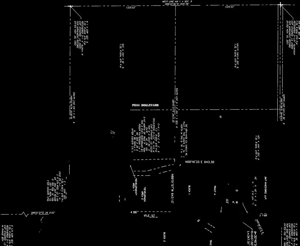
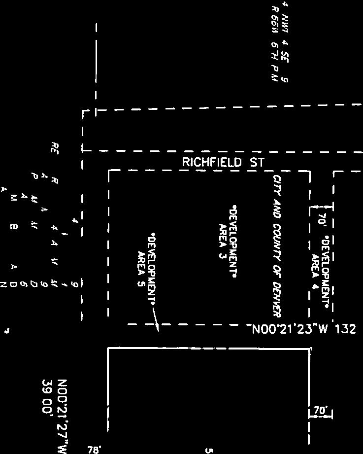
2 Rezoning Application #2015I E. 64th., Rifle St., Salida St., Telluride Way & 6297 Tower Rd. 5/2/16 Page 2 prohibit single unit residential between 62 nd Avenue and 56 th Avenue. In addition, the UO-1 Overlay applies to property zoned C-MU-30 in the area, which allows adult uses. All requested Zone Districts will be regulated by the Airport Influence Overlay Zone (AIO) which limits residential uses, prohibits surface parking as a primary use, and requires certain easements and rights of way for passage of aircraft. The following Zone Districts are requested: o C-MX-8 and C-MX-12 are requested close to the 61 st and Peña station and stand for Urban Center-Mixed Use- 8 stories and 12 stories, respectively. C-MX districts are intended to encourage high intensity, mixed use, pedestrian oriented development and are generally applied to properties with good access to existing or planned multi-modal transportation facilities. o S-MX-8 and S-MX-12 are requested further from the 61 st and Peña station and stand for Suburban-Mixed Use-8 stories and 12 stories, respectively. S-MX districts are intended to encourage mixed use development with more flexible standards that balance pedestrian and automobile-oriented design. S-MX is generally applied to properties with less access to multi-modal transportation facilities compared to Urban Neighborhood Contexts. o S-MX-8A is a hybrid between Suburban and Urban Neighborhood Contexts and allows some automobile oriented design flexibility while requiring pedestrian oriented design along Primary Streets. S-MX-8A is requested for certain properties along 60 th and 61 st Avenues, which are key pedestrian connections identified in the Station Area Plan. o S-CC-5 is requested for properties furthest from the 61 st and Peña station near Tower Road, a major arterial street. S-CC-5 stands for Suburban-Commercial Corridor-5 stories. S-CC districts are intended to encourage commercial development with more flexible standards that balance pedestrian and automobile-oriented design. S-CC districts are generally applied to properties with less access to multi-modal transportation facilities and along automobile-dominated corridors. o Further details of the zone districts can be found in Articles 3, 7, and 9 of the Denver Zoning Code (DZC). Existing Context The site is located in a generally undeveloped area of northeast Denver approximately 4 miles southwest of Denver International Airport. The entire site is vacant land as is most of the surrounding area, with the exception of a rural single unit house to the north and a few conventional suburban hotels and a restaurant to the east. The University of Colorado A-Line commuter train is located to the west of the site, running parallel to Peña Blvd. A station is located at the 61 st Avenue alignment, providing convenient public transit access when the service begins operating in the spring of this year. The following table summarizes the existing context proximate to the subject site: Site Existing Zoning C-MU-10 WVRS & CONDITIONS, C- MU-20 WVRS & Existing Land Use Vacant Land Existing Building Form/Scale Vacant Land Existing Block, Lot, Street Pattern Vacant Land. Rectangular grid
3 Rezoning Application #2015I E. 64th., Rifle St., Salida St., Telluride Way & 6297 Tower Rd. 5/2/16 Page 3 North South East West Existing Zoning CONDITIONS, C- MU-30 WVRS AND CONDITIONS UO-1 C-MU-10, 20 WVRS AND CONDITIONS C-MU-20, 30 WVRS AND CONDITIONS UO-1 C-MU-10, 20, WVRS AND CONDITIONS GTWY DIA, C-MU-30 WVRS AND CONDITIONS UO-1 Existing Land Use Vacant Land, ranch Vacant Land Hotels, restaurant Vacant Land Existing Building Form/Scale Vacant Land, 1 story single unit house Vacant Land 1-4 story automobileoriented hotel and retail buildings Vacant Land Existing Block, Lot, Street Pattern developing in surrounding area.

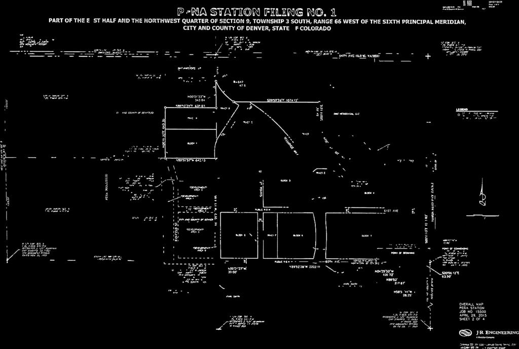
4 Rezoning Application #2015I E. 64th., Rifle St., Salida St., Telluride Way & 6297 Tower Rd. 5/2/16 Page 4 1. Proposed Rezoning

5 Rezoning Application #2015I E. 64th., Rifle St., Salida St., Telluride Way & 6297 Tower Rd. 5/2/16 Page 5 2. GDP The 61 st and Peña General Development Plan was approved in 2014 and provides a framework for infrastructure development, distribution of land uses, and strategies for enhanced urban design, parking management, and construction phasing. A key objective of the plan is to maximize access to the 61 st and Peña commuter rail station. Some of the key planned improvements include the development of the Blue Grama Draw and First Creek open space corridors, a transit plaza and park with direct pedestrian and visual connections to the station, and a hierarchical system of connected streets that enable convenient circulation and specify key pedestrian corridors consistent with the Station Area Plan, such as 60 th and 61 st Avenues and Aviation Place. 3. Existing Zoning The site is currently zoned C-MU-10 with waivers and conditions AIO, C-MU-20 with waivers and conditions, and C-MU-30 with waivers and conditions UO-1 AIO. C-MU is a Former Chapter 59 zone district and stands for Commercial Mixed Use. C-MU-10 is intended to encourage more

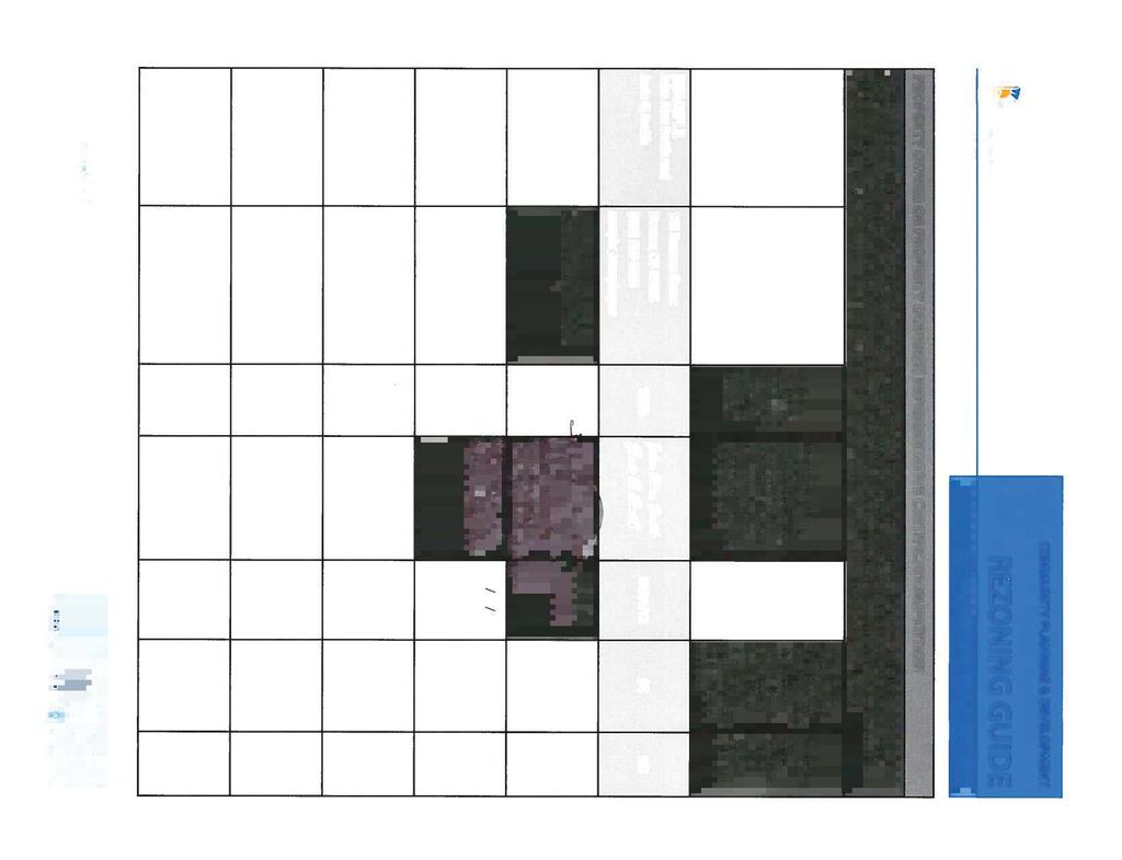
6 Rezoning Application #2015I E. 64th., Rifle St., Salida St., Telluride Way & 6297 Tower Rd. 5/2/16 Page 6 intensive and pedestrian oriented mixed use development compared to C-MU-20 and C-MU-30. C-MU-20 allows additional auto-oriented uses and C-MU-30 allows for an even wider range of uses. C-MU-10 permits a higher density of 2:1 Floor Area Ratio (F.A.R.) compared to 1:1 F.A.R. for the C-MU-20 and C-MU-30 Zone Districts. The waivers and conditions restrict residential uses in each Zone District due to the proximity of Denver International Airport. The UO-1 Overlay applies to the C-MU-30 district and allows adult oriented uses. 4. Existing Land Use Map Areas with no color are vacant.


7 Rezoning Application #2015I E. 64th., Rifle St., Salida St., Telluride Way & 6297 Tower Rd. 5/2/16 Page 7 5. Existing Building Form and Scale
8 Rezoning Application #2015I E. 64th., Rifle St., Salida St., Telluride Way & 6297 Tower Rd. 5/2/16 Page 8 Summary of City Agency Referral Comments As part of the DZC review process, the rezoning application is referred to potentially affected city agencies and departments for comment. A summary of agency referral responses follows: Environmental Health: Approved. Comments: DEH concurs with the proposed zoning change. General Notes: Most of Colorado is high risk for radon, a naturally occurring radioactive gas. Due to concern for potential radon gas intrusion into buildings, DEH suggests installation of a radon mitigation system in structures planned for human occupation or frequent use. It may be more cost effective to install a radon system during new construction rather than after construction is complete. Denver s Noise Ordinance (Chapter 36 Noise Control, Denver Revised Municipal Code) identifies allowable levels of noise. Properties undergoing Re-Zoning may change the acoustic environment, but must maintain compliance with the Noise Ordinance. Compliance with the Noise Ordinance is based on the status of the receptor property (for example, adjacent Residential receptors), and not the status of the noise-generating property. Violations of the Noise Ordinance commonly result from, but are not limited to, the operation or improper placement of HV/AC units, generators, and loading docks. Construction noise is exempted from the Noise Ordinance during the following hours, 7am 9pm (Mon Fri) and 8am 5pm (Sat & Sun). Variances for nighttime work are allowed, but the variance approval process requires 2 to 3 months. For variance requests or questions related to the Noise Ordinance, please contact Paul Riedesel, Denver Environmental Health ( ). Scope & Limitations: DEH performed a limited search for information known to DEH regarding environmental conditions at the subject site. This review was not intended to conform to ASTM standard practice for Phase I site assessments, nor was it designed to identify all potential environmental conditions. In addition, the review was not intended to assess environmental conditions for any potential right-of-way or easement conveyance process. The City and County of Denver provides no representations or warranties regarding the accuracy, reliability, or completeness of the information provided. Asset Management: Approve No comments. Parks: Approved Development Services - Transportation: Approve Rezoning Only - Will require additional information at Site Plan Review Public Works City Surveyor: Approved with revised legal description. Aviation: 1. Fulenwider has previously recorded avigation easements on their property during a prior rezoning effort in the 1990 s. The areas covered include all of the land proposed to be rezoned by Fulenwider and Westfield. Because the easements run with the land they do not expire when the property is sold. Therefore, the existing avigation easements encumber all of the property proposed to be rezoned and DEN finds these sufficient for the purposes of the current rezoning effort. However, DEN will be modifying language to avigation easements going forward based
9 Rezoning Application #2015I E. 64th., Rifle St., Salida St., Telluride Way & 6297 Tower Rd. 5/2/16 Page 9 on a recent Colorado Court of Appeals case, Meadow Lake Airport Association v. Johnston Enterprises of Colorado Springs, LLC 12CA2189 (Dec. 3, 2015) to clarify its intent that the avigation easements are broadly intended for the use and benefit of DEN and all members of the general public who may use DIA and all other effects that may reasonably be caused by future development and/or expansion of DIA operations. 2. Due to the adjacency of the proposed development to Pena Boulevard, DIA requests that a traffic impact study be conducted and submitted for review that includes potential impacts to Peña Boulevard. DIA owns, operates and maintains Peña Boulevard as the Airport s primary access road and must ensure a high level of service for Airport passengers, employees and users. 3. The proposed development site is located approximately 19,330 feet from existing Runway 7L/25R. In addition, the proposed development site is located approximately 16,000 ft. southwest of proposed Future Runway 7R/25L centerline at DIA. 4. The proposed development site is located outside of the 65 DNL (or greater) noise contour at full build-out. However, due to its proximity to the airport, the property may be subject to frequent aircraft overflights, and noise levels (less than 65 DNL) associated with aircraft departures on Future Runway 7R/25L. 5. The proposed development underlies the Federal Aviation Administration (FAA)-promulgated 14 CFR part 77 navigable airspace associated with the DIA (see attachment). Any future building/structure to be situated on the subject property will be located within 20,000 ft. of an existing runway at DIA, and may be height restricted. As such, in accordance with 14 CFR Part 77, the Proponent will be required to file notice (via FAA Form , Notice of Proposed Construction or Alteration) with the FAA for each and every building, structure or other tall objects that may penetrate a 100:1 slope that begins from the runway. See attached FAA Advisory Circular (AC) 70/7460-2K, Proposed Construction or Alteration of Objects that May Affect the Navigable Airspace, for further guidance. Should future development meet the notification criteria, this submittal should be made after a development plan has been submitted to the City and County of Denver. This submittal may be made via the FAA s Obstruction Evaluation website: Should the Proponent have any questions regarding the FAA Notice, please have them contact the DIA Planning Office at Public Review Process CPD staff provided informational notice of receipt of the rezoning application to affected members of City Council and registered neighborhood organizations on January 20 th, The property has been legally posted for a period of 15 days announcing the March 2 nd, 2016 Denver Planning Board public hearing, and written notification of the hearing has been sent to all affected registered neighborhood organizations and City Council members. Following Planning Board review, the rezoning application will be referred to the Planning and Neighborhoods (PLAN) Committee of the City Council for review at a public meeting. The PLAN Committee meeting is tentatively scheduled for March 16th, Following PLAN committee review, the rezoning application is typically referred to the full City Council for final action at a public hearing. As of the date of this staff report, no comments from RNOs or the public have been received regarding this application.
10 Rezoning Application #2015I E. 64th., Rifle St., Salida St., Telluride Way & 6297 Tower Rd. 5/2/16 Page 10 Criteria for Review / Staff Evaluation The criteria for review of this rezoning application are found in DZC, Sections and , as follows: DZC Section Consistency with Adopted Plans 2. Uniformity of District Regulations and Restrictions 3. Public Health, Safety and General Welfare DZC Section Justifying Circumstances 2. Consistency with Neighborhood Context Description, Zone District Purpose and Intent Statements 1. Consistency with Adopted Plans The following adopted plans apply to this property: Denver Comprehensive Plan 2000 Blueprint Denver (2002) 61 st and Peña Station Area Plan (2014) Denver Comprehensive Plan 2000 The proposal is consistent with many Denver Comprehensive Plan strategies, including: Environment Strategy 2-B Protect and improve air quality Reducing vehicular pollution by expanding the use of transit and other travel alternatives, supporting telecommuting and homebased employment, increasing the mix of uses within neighborhoods, and expanding the use of alternative fuels. Land Use Strategy 4-A Encourage mixed-use, transit-oriented development that makes effective use of existing transportation infrastructure, supports transit stations, increases transit patronage, reduces impact on the environment, and encourages vibrant urban centers and neighborhoods Land Use Strategy 4-B Ensure that land-use policies and decisions support a variety of mobility choices, including light rail, buses, paratransit, walking and bicycling, as well as convenient access for people with disabilities. Mobility Strategy 3-B Promote transit-oriented development (TOD) as an urban design framework for urban centers and development areas. Development at transit stations should provide both higher ridership to the transit system and viability and walkability in the area. Mobility Strategy 4-E Continue to promote mixed-use development, which enables people to live near work, retail and services. The proposed map amendment will enable higher intensity, transit oriented development close to a commuter rail station, which will facilitate the increased use of public transportation, provide additional

11 Rezoning Application #2015I E. 64th., Rifle St., Salida St., Telluride Way & 6297 Tower Rd. 5/2/16 Page 11 mobility choices, and allow people to live closer to employment and services. As such, the requested rezoning is consistent with these plan recommendations. Blueprint Denver According to the 2002 Plan Map adopted in Blueprint Denver, this site has a concept land use of Transit Oriented Development, Open Space, and Mixed Use and is located in an Area of Change Blueprint Denver Plan Map Future Land Use Mixed Use areas have a sizable employment base as well as housing. Intensity is higher in mixed-use areas than in other residential areas. Land uses are not necessarily mixed in each building or development or even within each block. But within the neighborhood, residential and non-residential
12 Rezoning Application #2015I E. 64th., Rifle St., Salida St., Telluride Way & 6297 Tower Rd. 5/2/16 Page 12 uses are within walking distance of one another. (p.41) Transit Oriented Development provides A balanced mix of uses (residential, retail, office, entertainment, public facilities and others), compact, mid- to high-density development in close proximity to transit, emphasizing a pedestrian-friendly and attractive pedestrian environment, and attractive, multi-story buildings facing the station and adjacent streets (p. 44) The requested Zone Districts will encourage medium to high intensity mixed use and commercial development, reduce parking close to the commuter rail station, and contribute to a pedestrian friendly environment, especially along key multi-modal streets and close to the rail station. In addition, all proposed Zone Districts allow Open Space which will be provided in accordance with the approved General Development Plan at the time of Site Development Plan review. Area of Change As noted, the site is in an Area of Change. In general, The goal for Areas of Change is to channel growth where it will be beneficial and can best improve access to jobs, housing and services with fewer and shorter auto trips (p. 127). The rezoning application is consistent with the Blueprint Denver Area of Change recommendations. Access to jobs, housing, and services can improve in higher intensity, mixed use, and commercial Zone Districts such as those requested. In addition this site has good access to the 61 st / Peña University of Colorado A-Line commuter rail station which further warrants the requested high intensity Zone Districts. Street Classifications Blueprint Denver classifies Tower Road as a Commercial Arterial. According to Blueprint Denver, arterials typically serve commercial areas that contain many small retail strip centers with buildings set back behind front parking lots. Because of this, strip commercial arterials have many intersections and driveways that provide access to adjacent businesses. (p. 58) Consistent with this description, the requested S-MX-8A and S-CC-5 zone districts will facilitate retail and commercial uses and allow for flexible parking configurations along Tower Road. Small Area Plan: 61 st and Peña Station Area Plan The 61 st and Peña Station Area Plan, adopted by City Council in 2014, applies to the subject property. The Plan establishes a long range vision for the development of the station area as a vibrant, walkable, and transit-oriented community. The plan includes recommendations for land use, building heights, urban design, pedestrian and bicycle improvements, open space, and other elements.
 Four Land Use Types are recommended for the requested rezoning area: o Transit Community Core: shows the greatest attention to urban design within the station area, providing housing,")

13 Rezoning Application #2015I E. 64th., Rifle St., Salida St., Telluride Way & 6297 Tower Rd. 5/2/16 Page 13 Land Use Recommendations (p. 12) Four Land Use Types are recommended for the requested rezoning area: o Transit Community Core: shows the greatest attention to urban design within the station area, providing housing, hospitality services, and employment opportunities for a diverse population in a configuration that facilitates pedestrian and transit access. The C-MX-8, C-MX-12, S-MX-8A, and S-MX-8 Zone Districts are requested within this Land Use Type and are consistent with the description. Each of these Zone Districts encourages mixed use development, including housing, hospitality, and employment as well as pedestrian oriented design.
14 Rezoning Application #2015I E. 64th., Rifle St., Salida St., Telluride Way & 6297 Tower Rd. 5/2/16 Page 14 o o o Mixed-Use Employment: predominately office and commercial employment uses with a variety of building forms. The opportunity for compatible multi-family uses with strong station connectivity also exists. The S-MX-12, S-MX-8, and S-MX-8AZone Districts are requested within this and Use type and are consistent with the description. Each of these Zone Districts encourage mixed use, office, and commercial employment with a variety of building forms. Town Center: a variety of shopping, entertainment, service, and employment needs provided at a scale that can serve several nearby neighborhoods and should be a focal point of the corridor with design features that identify the area as a gateway to the station area. The S-MX-8A Zone District is requested within this Land Use Type and is consistent with the description. The Zone District encourages retail, entertainment, service and employment as well as pedestrian oriented frontages that will contribute to the establishment of a gateway entrance to the station area. Commercial Corridor: is influenced by the presence of one or more major arterials on the boundary of the station area and generally more than one-half mile from the rail platform. Greater flexibility in use and form is expected in the commercial corridor areas, providing visual and physical access to a variety of uses at different scales and accommodating auto traffic, major bus routes, and pedestrian activity. The S-CC-5 Zone District is requested within this Land Use Type and is consistent with the description. The Zone District is intended to be applied along major arterials and provides greater flexibility to accommodate a higher degree of vehicular traffic.
 o Allow taller building forms with higher densities and greater emphasis on pedestrian orientation near the station.")
15 Rezoning Application #2015I E. 64th., Rifle St., Salida St., Telluride Way & 6297 Tower Rd. 5/2/16 Page 15 Building Height Recommendations: (p. 13) o Allow taller building forms with higher densities and greater emphasis on pedestrian orientation near the station. As development densities decrease further from the station, allow a wider range of building forms in the mixed-use areas. o Promote varied building heights throughout the station area while capitalizing on the best locations to site prominent buildings with greater intensities. The C-MX-8, C-MX-12, S-MX-12, S-MX-8, S-MX-8A, and S-CC-5 Zone Districts are consistent with the building height recommendations, as they provide a variety of building heights, require a heightened pedestrian orientation closer to the station, and allow greater flexibility further from the station. The zone districts are also proposed to be mapped consistent with the recommended building heights map in the station area plan.
16 Rezoning Application #2015I E. 64th., Rifle St., Salida St., Telluride Way & 6297 Tower Rd. 5/2/16 Page 16 Urban Design Recommendations: (p. 24) Buildings with active edges may include the following elements: o Prominent, street-facing entries o Ground floor windows and entrances
17 Rezoning Application #2015I E. 64th., Rifle St., Salida St., Telluride Way & 6297 Tower Rd. 5/2/16 Page 17 o o o o Pedestrian-oriented design emphasizing pedestrian comfort, safety, scale and amenities Building entrances that meet the sidewalk Entries and active uses in situations where parking is on the ground floor Stoops, raised porches, terraces, and small quasi-public open space in lower density residential areas may be appropriate Building Frontages: A fundamental urban design principle is to have continuous building fronts define the vital public realm. This urban design principle is applicable on key streets throughout the station area and is considered vital to the overall pedestrian experience. As the street grid is extended in the station area, continuous building fronts should be considered on key streets. Building frontages may contain the following elements: o Building edges within a build-to zone o No surface parking between the primary structure and the street o Scaling elements to break up the appearance of tall buildings and continuous street edges The C-MX-8, C-MX-12 and S-MX--A are the requested zone districts adjacent to the identified Active Edge and Building Frontage corridors and are consistent with their recommended design elements. Each Zone District requires pedestrian oriented frontages along the identified corridors. 2. Uniformity of District Regulations and Restrictions The proposed rezoning to S-MX-8 AIO, S-MX-8A AIO, S-MX-12 AIO, C-MX-8 AIO, C-MX-12 AIO, and S-CC-5 AIO will result in the uniform application of zone district building form, use and design regulations. 3. Public Health, Safety and General Welfare The proposed official map amendment furthers the public health, safety, and general welfare of the City primarily through implementation of the city s adopted land use plans. 4. Justifying Circumstance The application identifies several changed or changing conditions as the Justifying Circumstance under DZC Section A.4, The land or its surrounding environs has changed or is changing to such a degree that it is in the public interest to encourage a redevelopment of the area or to recognize the changed character of the area. As discussed above, many adopted plan recommendations state that redevelopment of the area is desired. The recently adopted 61 st and Peña Station Area Plan promotes changing conditions, specifically encouraging the conversion of vacant land to intensive transit oriented development. The University of Colorado A-Line commuter rail project connecting Denver International Airport to Denver Union Station is currently under construction and a station will serve the proposed rezoning area. The station will encourage additional changes in the form of more intensive development. This is an appropriate justifying circumstance for the proposed rezoning.
18 Rezoning Application #2015I E. 64th., Rifle St., Salida St., Telluride Way & 6297 Tower Rd. 5/2/16 Page Consistency with Neighborhood Context Description, Zone District Purpose and Intent Statements The requested C-MX-8 and C-MX-5 zone districts are within the Urban Center Neighborhood Context. The Neighborhood Context generally consists of multi-unit residential and mixed-use commercial strips and commercial centers (DZC, Division 7.1). The requested S-MX-12, S-MX-8, S-MX-8A, and S-CC-5 are within the Suburban Neighborhood Context. The neighborhood context generally consists of single and multi-unit residential, commercial strips and centers and office parks (DZC, Division 3.1) The Urban Center Mixed Use Zone Districts are intended to promote safe, active, and pedestrian-scaled, diverse areas through the use of town house, row house, apartment, and shopfront building forms that clearly define and activate the public street edge. C-MX-8 applies to areas or intersections served primarily by arterial streets where a building scale of 2 to 8 stories is desired. C-MX-12 applies to areas or intersections served primarily by major arterial streets where a building scale of 3 to 12 stories is desired. The requested rezoning is consistent with this intent, as the Zone Districts are intended to provide a mix of uses with a pedestrian oriented design and are requested in locations served by Telluride Road, a major arterial street. The Suburban Mixed Use Zone Districts are intended to promote safe, active, pedestrian-scaled, diverse areas and enhance the convenience and ease of walking, shopping and public gathering within and around the city s neighborhoods. S-MX-8 applies to areas or intersections served primarily by arterial streets where a building scale of 1 to 8 stories is desired. S-MX-12 applies to areas or intersections served primarily by major arterial streets where a building scale of 1 to 12 stories is desired. The requested rezoning is consistent with this intent, as the Zone Districts are intended to provide a mix of uses with pedestrian oriented design and are requested in locations served by Telluride Way and Tower Road, which are major arterial streets. The Commercial Corridor Zone Districts are intended to balance the need for safe, active, and pedestrian-scaled, diverse areas with the need for convenient automobile access. S-CC-5 applies primarily to auto-oriented arterial street corridors where a building scale of 1 to 5 stories is desired. The requested rezoning is consistent with this intent, as the Zone District is intended to provide a balance of pedestrian and automobile oriented design and is requested adjacent to Tower Road, an auto dominated arterial street. Staff Recommendation Based on the analysis set forth above, CPD staff finds that the application for rezoning the property located at E. 64th Ave., Rifle St., Salida St., Telluride Way & 6297 Tower Rd. to S-MX-8 AIO, S-MX-8A AIO, S-MX-12 AIO, C-MX-8 AIO, C-MX-12 AIO, ands-cc-5 AIO zone districts meets the requisite review criteria. Accordingly, staff recommends that the Denver Planning Board recommend approval to the Denver City Council. Planning Board Recommendation
19 Rezoning Application #2015I E. 64th., Rifle St., Salida St., Telluride Way & 6297 Tower Rd. 5/2/16 Page 19 Following the public hearing, the Planning Board Voted to recommend that the Denver City Council approve the rezoning application. Attachments 1. Application 2. Waivers and conditions ordinances
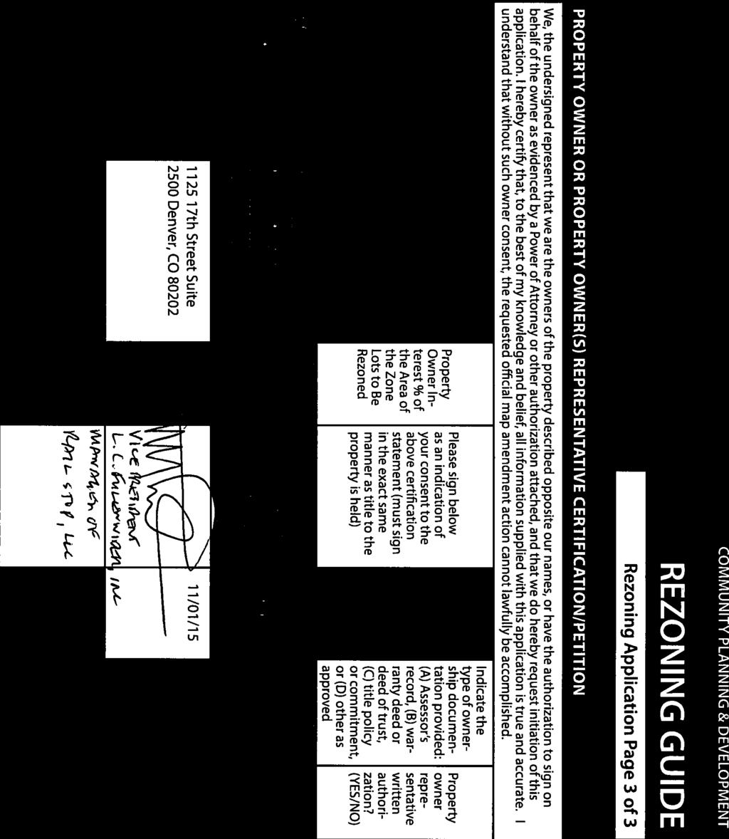
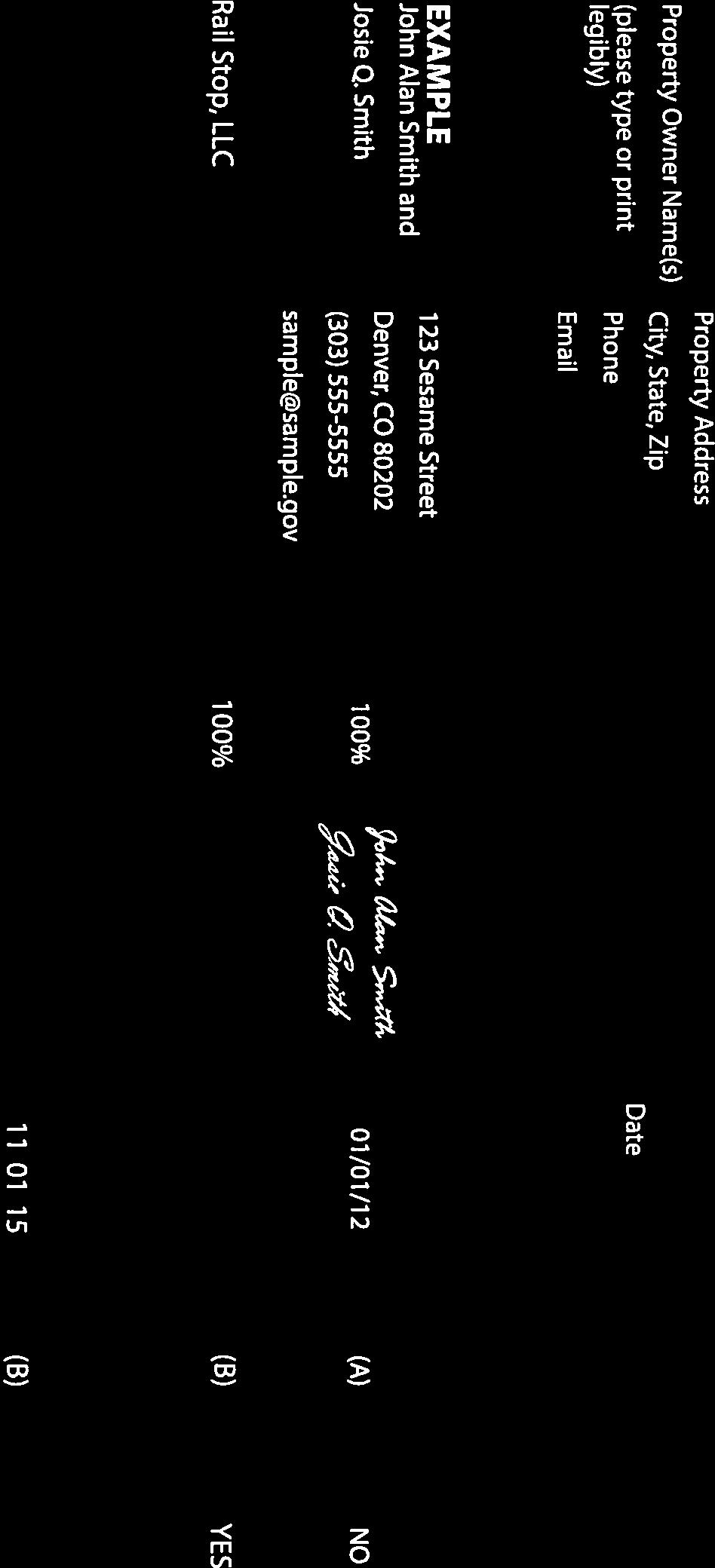
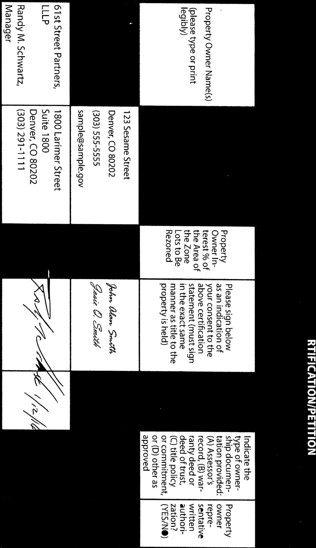
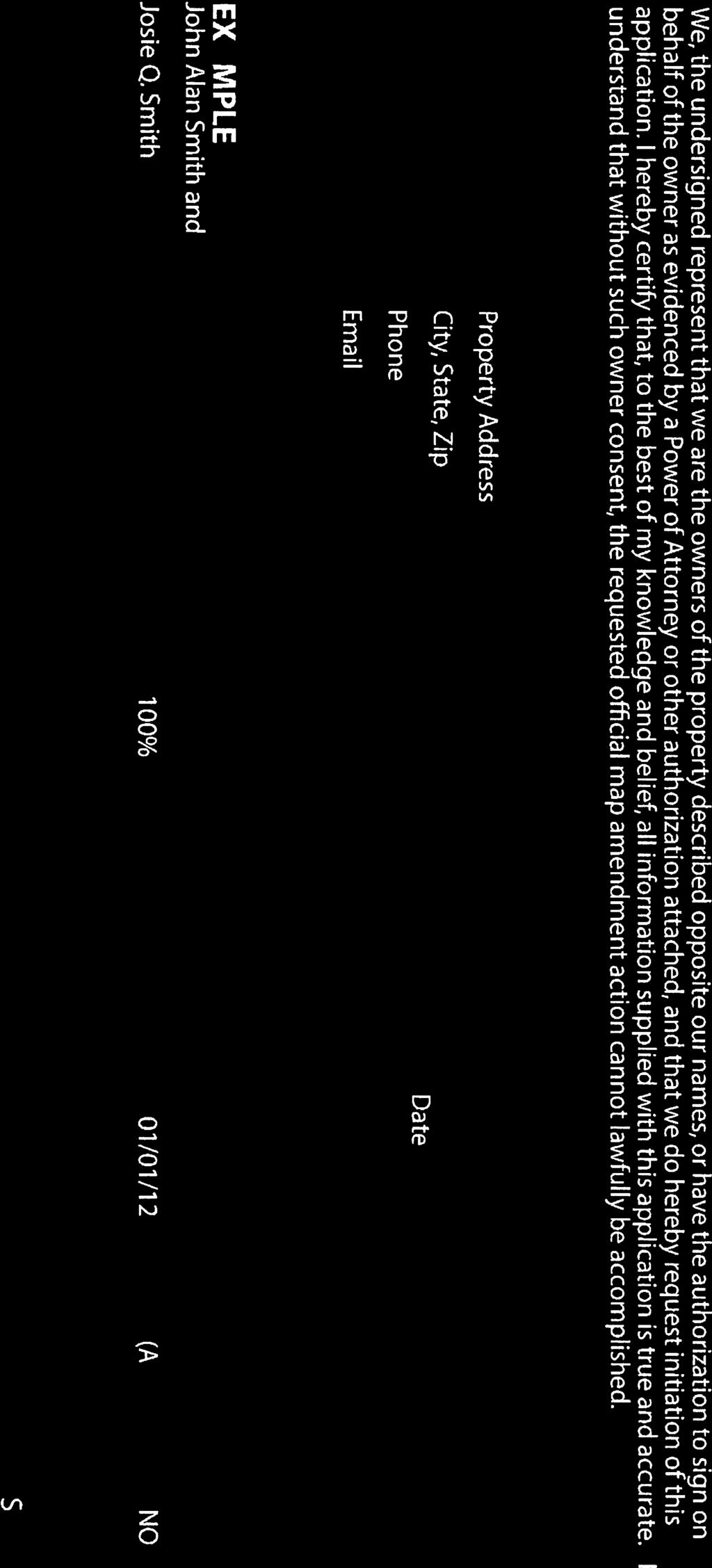
20 Zone Map Amendment (Rezoning) - Application COMMUNITY PLANNING & DEVELOPMENT REZONING GUIDE Rezoning Application Page 1 of 3 PROPERTY OWNER INFORMATION* CHECK IF POINT OF CONTACT FOR APPLICATION Property Owner Name Rail Stop, LLC; 61st Street Partners, LL PROPERTY OWNER(S) REPRESENTATIVE** CHECK IF POINT OF CONTACT FOR APPLICATION Representative Name Mark Throckmorton ; Randy M. Schwartz Address th Street Suite 2500; 1800 Lar Address th Street Suite 2500; 1800 Larimer City, State, Zip Denver, CO City, State, Zip Denver, CO Telephone ; Telephone ; mark@fulenwider.com; rschwartz@we *If More Than One Property Owner: All standard zone map amendment applications shall be initiated by all the owners of at least 51% of the total area of the zone lots subject to the rezoning application, or their representatives authorized in writing to do so. See page 3. mark@fulenwider.com; rschwartz@westfi **Property owner shall provide a written letter authorizing the representative to act on his/her behalf. Please attach Proof of Ownership acceptable to the Manager for each property owner signing the application, such as (a) Assessor s Record, (b) Warranty deed or deed of trust, or (c) Title policy or commitment dated no earlier than 60 days prior to application date. SUBJECT PROPERTY INFORMATION Location (address and/or boundary description): See Attachment Assessor s Parcel Numbers: Area in Acres or Square Feet: Current Zone District(s): , , , , Acres C-MU-10 WVRS & CONDITIONS, C-MU-20 WVRS & CONDITIONS, C-MU-30 WV PROPOSAL Proposed Zone District: S-MX-8 AIO, S-MX-8 -A AIO, S-MX-12 AIO, C-MX-8 AIO, C-MX-12 AIO, S-CC-5 A Does the proposal comply with the minimum area requirements specified in DZC Sec : Yes No Last updated: February 4, 2015 Return completed form to rezoning@denvergov.org 201 W. Colfax Ave., Dept. 205 Denver, CO rezoning@denvergov.org 2015I January 19, 2016 Fees waived per

21 COMMUNITY PLANNING & DEVELOPMENT REZONING GUIDE Rezoning Application Page 2 of 3 REVIEW CRITERIA Consistency with Adopted Plans: The proposed official map amendment is consistent with the City s adopted plans, or the proposed rezoning is necessary to provide land for a community need that was not anticipated at the time of adoption of the City s Plan. General Review Criteria: The proposal must comply with all of the general review criteria DZC Sec Additional Review Criteria for Non-Legislative Rezonings: The proposal must comply with both of the additional review criteria DZC Sec Please provide an attachment describing relevant adopted plans and how proposed map amendment is consistent with those plan recommendations; or, describe how the map amendment is necessary to provide for an unanticipated community need. Uniformity of District Regulations and Restrictions: The proposed official map amendment results in regulations and restrictions that are uniform for each kind of building throughout each district having the same classification and bearing the same symbol or designation on the official map, but the regulations in one district may differ from those in other districts. Public Health, Safety and General Welfare: The proposed official map amendment furthers the public health, safety, and general welfare of the City. Justifying Circumstances - One of the following circumstances exists: The existing zoning of the land was the result of an error. The existing zoning of the land was based on a mistake of fact. The existing zoning of the land failed to take into account the constraints on development created by the natural characteristics of the land, including, but not limited to, steep slopes, floodplain, unstable soils, and inadequate drainage. The land or its surroundings has changed or is changing to such a degree that it is in the public interest to encourage a redevelopment of the area to recognize the changed character of the area. It is in the public interest to encourage a departure from the existing zoning through application of supplemental zoning regulations that are consistent with the intent and purpose of, and meet the specific criteria stated in, Article 9, Division 9.4 (Overlay Zone Districts), of this Code. Please provide an attachment describing the justifying circumstance. The proposed official map amendment is consistent with the description of the applicable neighborhood context, and with the stated purpose and intent of the proposed Zone District. Please provide an attachment describing how the above criterion is met. REQUIRED ATTACHMENTS Please ensure the following required attachments are submitted with this application: Legal Description (required to be attached in Microsoft Word document format) Proof of Ownership Document(s) Review Criteria ADDITIONAL ATTACHMENTS Please identify any additional attachments provided with this application: Written Authorization to Represent Property Owner(s) Please list any additional attachments: S-MX-8A is a district in a new proposed series of districts to be approved prior to or concurrently with the mapping; *Ownership Parcel Map; Ownership Signatures Last updated: February 4, 2015 Return completed form to rezoning@denvergov.org 201 W. Colfax Ave., Dept. 205 Denver, CO rezoning@denvergov.org 2015I January 19, 2016 Fees waived per
22 2015I January 19, 2016 Fees waived per


23 2015I January 19, 2016 Fees waived per
24 About Wayne Español Search For this Record... Filing history and documents Get a certificate of good standing File a form Subscribe to notification Unsubscribe from notification Details Name Summary Pena Station Development Corporation Business Home Business Information Business Search FAQs, Glossary and Information Status Good Standing Formation date 02/02/2015 ID number Form Corporation Jurisdiction Colorado Periodic report month February Term of duration Perpetual Principal office street address 1125 Seventeenth Street, Suite 2500, Denver, CO 80202, United States Principal office mailing address n/a Registered Agent Name Street address Mailing address L C Fulenwider 1125 Seventeenth Street, Suite 2500, Denver, CO 80202, United States n/a Filing history and documents Get a certificate of good standing Get certified copies of documents File a form Set up secure business filing Subscribe to notification Unsubscribe from notification Back Terms and Conditions 2015I January 19, 2016 Fees waived per
25 About Wayne Español For this Record... Filing history and documents Get a certificate of good standing File a form Subscribe to notification Unsubscribe from notification Details Name Summary DIBC RESIDENTIAL, LLC Business Home Business Information Business Search FAQs, Glossary and Information Status Good Standing Formation date 12/26/1996 ID number Form Limited Liability Company Jurisdiction Colorado Periodic report month December Term of duration 12/26/2026 Principal office street address 1125 Seventeetnh Street, Suite 2500, Denver, CO 80202, United States Principal office mailing address n/a Registered Agent Name Street address Mailing address L. C. FULENWIDER III 1125 Seventeenth Street, Suite 2500, Denver, CO 80202, United States n/a Filing history and documents Get a certificate of good standing Get certified copies of documents File a form Set up secure business filing Subscribe to notification Unsubscribe from notification Terms and Conditions 2015I January 19, 2016 Fees waived per


26 About Wayne Español Search For this Record... Filing history and documents Get a certificate of good standing File a form Subscribe to notification Unsubscribe from notification Details Name Rail Stop LLC Summary Business Home Business Information Business Search FAQs, Glossary and Information Status Good Standing Formation date 01/29/2015 ID number Form Limited Liability Company Jurisdiction Colorado Periodic report month January Term of duration Perpetual Principal office street address th Street, Suite 2500, Denver, CO 80202, United States Principal office mailing address n/a Registered Agent Name Street address Mailing address John W. O'Dorisio Jr th Street, Suite 2600, Denver, CO 80202, United States n/a Filing history and documents Get a certificate of good standing Get certified copies of documents File a form Set up secure business filing Subscribe to notification Unsubscribe from notification Back Terms and Conditions 2015I January 19, 2016 Fees waived per

27 2015I January 19, 2016 Fees waived per

28 2015I January 19, 2016 Fees waived per


29 2015I January 19, 2016 Fees waived per

30 2015I January 19, 2016 Fees waived per

31 2015I January 19, 2016 Fees waived per

32 2015I January 19, 2016 Fees waived per

33 2015I January 19, 2016 Fees waived per

34 2015I January 19, 2016 Fees waived per

35 2015I January 19, 2016 Fees waived per

36 2015I January 19, 2016 Fees waived per

37 2015I January 19, 2016 Fees waived per

38 2015I January 19, 2016 Fees waived per

39 2015I January 19, 2016 Fees waived per

40 2015I January 19, 2016 Fees waived per

41 2015I January 19, 2016 Fees waived per

42 2015I January 19, 2016 Fees waived per


43 2015I January 19, 2016 Fees waived per

44 2015I January 19, 2016 Fees waived per

45 2015I January 19, 2016 Fees waived per

46 2015I January 19, 2016 Fees waived per

47 2015I-00101


48 January 19, 2016 Fees waived per
49
50 2015I January 19, 2016 Fees waived per
51
52 2015I January 19, 2016 Fees waived per
53
54 2015I January 19, 2016 Fees waived per
55
56 2015I January 19, 2016 Fees waived per
57
58 2015I January 19, 2016 Fees waived per
59
60 2015I January 19, 2016 Fees waived per
61
62 2015I January 19, 2016 Fees waived per
63
64 2015I January 19, 2016 Fees waived per
65
66 2015I January 19, 2016 Fees waived per
67
68 2015I January 19, 2016 Fees waived per
69
70 2015I January 19, 2016 Fees waived per
71
72 2015I January 19, 2016 Fees waived per
73
74 2015I January 19, 2016 Fees waived per
75
76 2015I January 19, 2016 Fees waived per


77 2015I January 19, 2016 Fees waived per


78 2015I January 19, 2016 Fees waived per
79 Community Planning and Development Rezoning Map Application #2105I st and Pena Boulevard November 16, 2015 Current Zoning Current zoning on the properties in this map application are pursuant to former Chapter 59 with waivers and conditions and new Denver Zoning Code UO-1 and AIO overlays are not applicable until underlying zoning is changed per and This is a proposed rezoning from the old chapter 59 code to the new Denver zone code. It will help City facilitate future zoning reviews under one code instead of two codes. Review Criteria Please provide an attachment describing relevant adopted plans and how the proposed map amendment is consistent with those plan recommendations. Relevant Adopted Plans Comprehensive Plan 2000 This map application is consistent with the comprehensive plan goals including: Managing growth and change through effective land use policies to sustain Denver s high quality of life Anticipating and meeting the expanding mobility needs of residents, businesses and visitors Expanding housing options for Denver s changing population Enhancing opportunities for people in need to work and participate fully in community life The 61 st and Pena Station GDP conforms to several key Comprehensive Plan strategies such as: o Promote the development of sustainable communities o Promote transit-oriented development (TOD) o Provide safe and convenient pedestrian and bicycle facilities o Invest in public infrastructure and amenities strategically o Preserve, enhance and extend the pattern and character of the primary street system, including the prevailing grid, interconnected parkways, detached sidewalks and tree lawns o Integrate sufficient open space and recreational amenities o Support mixed-se o Identify and capitalize on opportunities to develop housing along transit lines 2015I January 19, 2016 Fees waived per
80 o Support a variety of housing opportunities for Denver s current and future workforce, including the expected future needs of the Aerotropolis Blueprint Denver 2002: A Land Use and Transportation Plan Located in an Area of Change, the new rail station under construction at 61 st and Pena Boulevard has changed conditions surrounding this agricultural neighborhood. This map application is consistent with Blue Print Denver s goals and objectives including: Multimodal streets Pedestrian and transit supportive design Development of vacant and underused properties Street grid/connectivity Transit service and access Adequate parks and open space 61 st and Pena Station Area Plan This map application is consistent with the principles in the GDP and help to implement the Station Area Plan vision of: 1. Transit Community lot and block prioritization near station 2. Connected Multimodal connections, bicycle lane locations, and street grid considerations 3. Vibrant Local and regional publicly accessible open space integrated into the development 4. Catalyze Provides building height ranges, land use flexibility, and supports new mixed-use zoning 61 st and Pena General Development Plan This map application is consistent with the following GDP Guiding Principles Neighborhood links to the commuter rail station Organized around existing natural features Interconnected open space system Mix of land uses and priority to TOD location Alternatives for live, work and play Environmental protection though climate-adaptive landscaping, preservation of and enhancement of natural drainage ways Phase development over time to respond to the market 2015I January 19, 2016 Fees waived per
81 Parking strategies for short-mid, and long term parking needs Please provide an attachment describing the Justifying Circumstance The land and its surroundings has changed or is changing to such a degree that it is in the public interest to encourage a redevelopment of the area of change to recognize the changed character of the area. With the opening of the rail station platform at 61 st and Pena Boulevard Station anticipated for April of 2016, the land and its surroundings have clearly changed in a most positive manner. With the development of this area conforming to the Comprehensive Plan, Blueprint Denver, 61 st and Pena Station Area Plan and the 61 st and Pena Station GDP, the only remaining element necessary to implement the vision for this area of change is to change the existing zoning so it is consistent with the vision for 61 st and Pena Station Transit Oriented Development. By rezoning from the old Chapter 59 code to the new Denver Zone Code, the new zoning will facilitate the densities, the types and mixes of commercial, residential and retail uses, the build-to street frontages and all the sustainable elements necessary for a successful TOD community at Pena Station. Provide an attachment describing how the above criterian is met. The proposed official map amendment is consistent with the description of the applicable neighborhood context, and with the stated purpose and intent of the proposed zone district(s) The proposed zone districts in this map amendment conform to the stated purpose and intent of the Station Area Plan and GDP ( Plans ) within the Pena Station development area conforming to the Plans zone district locations, densities, building heights, mix of uses, build-to s, primary streets, transit connectivity, responsible phasing, pedestrian connectivity and sustainability components. 2015I January 19, 2016 Fees waived per
82
83
84
85
86
87
88
89
90
91
92
93
94
95
96
97
98
99
100
Land Use, Transportation, and Infrastructure Committee of the Denver City Council FROM: Scott Robinson, Senior City Planner DATE: March 22, 2018 RE:
 Community Planning and Development Planning Services 201 W. Colfax Ave., Dept. 205 Denver, CO 80202 p: 720.865.2915 f: 720.865.3052 www.denvergov.org/cpd TO: Land Use, Transportation, and Infrastructure
Land Use, Transportation, and Infrastructure Committee of Denver City Council FROM: Scott Robinson, Senior City Planner DATE: December 6, 2018 RE:
 Community Planning and Development Planning Services 201 W. Colfax Ave., Dept. 205 Denver, CO 80202 p: 720.865.2915 f: 720.865.3052 www.denvergov.org/cpd TO: Land Use, Transportation, and Infrastructure
REZONING GUIDE. Zone Map Amendment (Rezoning) - Application. Rezoning Application Page 1 of 3. Return completed form to
 - Application. Rezoning Application Page 1 of 3. Return completed form to") Zone Map Amendment (Rezoning) - Application COMMUNITY PLANNING & DEVELOPMENT REZONING GUIDE Rezoning Application Page 1 of 3 PROPERTY OWNER INFORMATION* CHECK IF POINT OF CONTACT FOR APPLICATION Property
Zone Map Amendment (Rezoning) - Application COMMUNITY PLANNING & DEVELOPMENT REZONING GUIDE Rezoning Application Page 1 of 3 PROPERTY OWNER INFORMATION* CHECK IF POINT OF CONTACT FOR APPLICATION Property
Official Zoning Map Amendment Application #2017I and 4889 South Quebec Street Rezoning from B-4 with waivers, UO-1, UO-2 to C-MX-20
 Community Planning and Development Planning Services 201 W. Colfax Ave., Dept. 205 Denver, CO 80202 p: 720.865.2915 f: 720.865.3052 www.denvergov.org/cpd TO: Denver Planning Board FROM: Jeff Hirt, Senior
REZONING GUIDE. Zone Map Amendment (Rezoning) - Application. Rezoning Application Page 1 of 3. Return completed form to
 - Application. Rezoning Application Page 1 of 3. Return completed form to") COMMUNITY PLANNING & DEVELOPMENT REZONING GUIDE Rezoning Application Page 1 of 3 Zone Map Amendment (Rezoning) - Application PROPERTY OWNER INFORMATION* PROPERTY OWNER(S) REPRESENTATIVE** CHECK IF POINT
COMMUNITY PLANNING & DEVELOPMENT REZONING GUIDE Rezoning Application Page 1 of 3 Zone Map Amendment (Rezoning) - Application PROPERTY OWNER INFORMATION* PROPERTY OWNER(S) REPRESENTATIVE** CHECK IF POINT
Denver City Council Land Use, Transportation, and Infrastructure Committee FROM: Courtney Levingston, Senior City Planner DATE: July 26, 2018 RE:
 TO: Denver City Council Land Use, Transportation, and Infrastructure Committee FROM: Courtney Levingston, Senior City Planner DATE: RE: Official Zoning Map Amendment Application #2017I-00151 Staff Report
Official Zoning Map Amendment Application #2017I Gaylord Street and York Street Rezoning from U-RH-2.5 to U-RX-3 and U-RX-5
 Community Planning and Development Planning Services 201 W. Colfax Ave., Dept. 205 Denver, CO 80202 p: 720.865.2915 f: 720.865.3052 www.denvergov.org/cpd TO: Denver Planning Board FROM: Elizabeth Weigle,
Request for Rezoning. Current Zoning: Proposed Zoning:
 TO: Denver City Council, Neighborhoods and Planning Committee FROM: Theresa Lucero, Senior City Planner DATE: March 31, 2016 RE: Zoning Map Amendment #2015I-00150 Rezoning from M-RX-5 to I-MX-3 Community
Staff Report and Recommendation Based on the criteria for review in the Denver Zoning Code, Staff recommends approval for Application #2017I
 TO: Denver Planning Board, Joel Noble, Chair FROM: Theresa Lucero, Senior City Planner DATE: RE: Official Zoning Map Amendment Application #2017I-00163 Staff Report and Recommendation Based on the criteria
REZONING GUIDE. Zone Map Amendment (Rezoning) - Application. Rezoning Application Page 1 of 3. Return completed form to
 - Application. Rezoning Application Page 1 of 3. Return completed form to") Zone Map Amendment (Rezoning) - Application COMMUNITY PLANNING & DEVELOPMENT REZONING GUIDE Rezoning Application Page 1 of 3 PROPERTY OWNER INFORMATION* CHECK IF POINT OF CONTACT FOR APPLICATION Property
Zone Map Amendment (Rezoning) - Application COMMUNITY PLANNING & DEVELOPMENT REZONING GUIDE Rezoning Application Page 1 of 3 PROPERTY OWNER INFORMATION* CHECK IF POINT OF CONTACT FOR APPLICATION Property
Land Use, Transportation, & Infrastructure Committee of the Denver City Council FROM: Chandler Van Schaack, Senior City Planner DATE: July 3, 2018 RE:
 Community Planning and Development Planning Services TO: Land Use, Transportation, & Infrastructure Committee of the Denver City Council FROM: Chandler Van Schaack, Senior City Planner DATE: July 3, 2018
Brad Buchanan, Executive Director, Department of Community Planning and Development
 TO: City Council FROM: Jeff Hirt, Senior City Planner DATE: RE: Official Zoning Map Amendment Application #2017I-00076 3400 Arkins Ct., 3460 Arkins Ct., 1900 35 th St, 1930 35th St., 1950 35 th St Rezoning
Official Zoning Map Amendment Application #2018I-00120
 Community Planning and Development Planning Services 201 W. Colfax Ave., Dept. 205 Denver, CO 80202 p: 720.865.2915 f: 720.865.3052 www.denvergov.org/cpd TO: Denver Planning Board FROM: Scott Robinson,
Official Zoning Map Amendment Application #2017I-00094
 Community Planning and Development Planning Services 201 W. Colfax Ave., Dept. 205 Denver, CO 80202 p: 720.865.2915 f: 720.865.3052 www.denvergov.org/cpd TO: Denver Planning Board FROM: Scott Robinson,
Block bounded by Newton St., 17 th Ave., Lowell Blvd., and 16 th Ave.; plus Meade Street (evens only)
") Community Planning and Development Planning Services 201 W. Colfax Ave., Dept. 205 Denver, CO 80202 p: 720.865.2915 f: 720.865.3052 www.denvergov.org/cpd TO: Denver Planning Board FROM: Sara White, AICP,
Community Planning and Development Planning Services 201 W. Colfax Ave., Dept. 205 Denver, CO 80202 p: 720.865.2915 f: 720.865.3052 www.denvergov.org/cpd TO: Denver Planning Board FROM: Sara White, AICP,
Article 3. SUBURBAN (S-) NEIGHBORHOOD CONTEXT
 NEIGHBORHOOD CONTEXT") Article 3. SUBURBAN (S-) NEIGHBORHOOD CONTEXT this page left intentionally blank Contents ARTICLE 3. SUBURBAN (S-) NEIGHBORHOOD CONTEXT DIVISION 3.1 NEIGHBORHOOD CONTEXT DESCRIPTION...3.1-1 Section 3.1.1
Article 3. SUBURBAN (S-) NEIGHBORHOOD CONTEXT this page left intentionally blank Contents ARTICLE 3. SUBURBAN (S-) NEIGHBORHOOD CONTEXT DIVISION 3.1 NEIGHBORHOOD CONTEXT DESCRIPTION...3.1-1 Section 3.1.1
REZONING GUIDE. Zone Map Amendment (Rezoning) - Application. Rezoning Application Page 1 of 3. Return completed form to
 - Application. Rezoning Application Page 1 of 3. Return completed form to") Zone Map Amendment (Rezoning) - Application COMMUNITY PLANNING & DEVELOPMENT REZONING GUIDE Rezoning Application Page 1 of 3 PROPERTY OWNER INFORMATION* CHECK IF POINT OF CONTACT FOR APPLICATION Property
Zone Map Amendment (Rezoning) - Application COMMUNITY PLANNING & DEVELOPMENT REZONING GUIDE Rezoning Application Page 1 of 3 PROPERTY OWNER INFORMATION* CHECK IF POINT OF CONTACT FOR APPLICATION Property
Official Zoning Map Amendment Application #2018I-00095
 Community Planning and Development Planning Services 201 W. Colfax Ave., Dept. 205 Denver, CO 80202 p: 720.865.2915 f: 720.865.3052 www.denvergov.org/cpd TO: Denver Planning Board FROM: Ella Stueve, Senior
Telephone AC / 21,960 SF G-MU-3 G-MX-3
 Zone Map Amendment (Rezoning) - Application PROPERTY OWNER INFORMATION* CHECK IF POINT OF CONTACT FOR APPLICATION Property Owner Name Siddhartha Rathod Address City, State, Zip Telephone Email COMMUNITY
Representative Name. Address. City, State, Zip. Telephone.
 COMMUNITY PLANNING & DEVELOPMENT ~~DENVER... THE MILE HIGH CITY REZONING GUIDE Zone Map Amendment (Rezoning)- Application Rezoning Application Page 1 of 3 Property Owner Name Philip M. Falco Address 730
Official Zoning Map Amendment Application #2018I-00067
 Community Planning and Development Planning Services 201 W. Colfax Ave., Dept. 205 Denver, CO 80202 p: 720.865.2915 f: 720.865.3052 www.denvergov.org/cpd TO: Denver Planning Board FROM: Courtney Levingston,
Official Zoning Map Amendment Application #2017I-00090
 Community Planning and Development Planning Services 201 W. Colfax Ave., Dept. 205 Denver, CO 80202 p: 720.865.2915 f: 720.865.3052 www.denvergov.org/cpd TO: Land Use, Transportation, & Infrastructure
Public Review of the Slot Home Text Amendment
 Public Review of the Slot Home Text Amendment The proposed amendments to the Denver Zoning Code have been informed by the Slot Home Strategy Report. This document has been developed out of a robust process
REZONING GUIDE. Zone Map Amendment (Rezoning) - Application. Rezoning Application Page 1 of 3. Return completed form to
 - Application. Rezoning Application Page 1 of 3. Return completed form to") Zone Map Amendment (Rezoning) - Application COMMUNITY PLANNING & DEVELOPMENT REZONING GUIDE Rezoning Application Page 1 of 3 PROPERTY OWNER INFORMATION* CHECK IF POINT OF CONTACT FOR APPLICATION Property
Zone Map Amendment (Rezoning) - Application COMMUNITY PLANNING & DEVELOPMENT REZONING GUIDE Rezoning Application Page 1 of 3 PROPERTY OWNER INFORMATION* CHECK IF POINT OF CONTACT FOR APPLICATION Property
Staff Report and Recommendation
 Community Planning and Development Planning Services 201 W. Colfax Ave., Dept. 205 Denver, CO 80202 p: 720.865.2915 f: 720.865.3052 www.denvergov.org/cpd TO: Denver Planning Board FROM: Andrew Webb, Senior
Staff Report and Recommendation Based on the criteria for review in the Denver Zoning Code, Staff recommends approval for application #2017I
 TO: Denver City Council, Land Use, Transportation and Infrastructure Committee FROM: Theresa Lucero, Senior City Planner DATE: RE: Official Zoning Map Amendment Application #2017I-00153 Staff Report and
Official Zoning Map Amendment Application #2015I Marion St. Rezoning from U-SU-A1 to U-MX-2x
 Community Planning and Development Planning Services 201 W. Colfax Ave., Dept. 205 Denver, CO 80202 p: 720.865.2915 f: 720.865.3052 www.denvergov.org/cpd TO: Denver City Council FROM: Courtland Hyser,
Based on the criteria for review in the Denver Zoning Code, Staff recommends approval for Application #2018I
 Community Planning and Development Planning Services 201 W. Colfax Ave., Dept. 205 Denver, CO 80202 p: 720.865.2915 f: 720.865.3052 www.denvergov.org/cpd TO: Denver Planning Board FROM: Chandler Van Schaack,
Article 6. GENERAL URBAN (G-) NEIGHBORHOOD CONTEXT
 NEIGHBORHOOD CONTEXT") Article 6. GENERAL URBAN (G-) NEIGHBORHOOD CONTEXT this page left intentionally blank Contents ARTICLE 6. GENERAL URBAN (G-) NEIGHBORHOOD CONTEXT DIVISION 6.1 NEIGHBORHOOD CONTEXT DESCRIPTION...6.1-1 Section
Article 6. GENERAL URBAN (G-) NEIGHBORHOOD CONTEXT this page left intentionally blank Contents ARTICLE 6. GENERAL URBAN (G-) NEIGHBORHOOD CONTEXT DIVISION 6.1 NEIGHBORHOOD CONTEXT DESCRIPTION...6.1-1 Section
Bylaw No , being "Official Community Plan Bylaw, 2016" Schedule "A" DRAFT
 Bylaw No. 2600-2016, being "Official Community Plan Bylaw, 2016" Schedule "A" Urban Structure + Growth Plan Urban Structure Land use and growth management are among the most powerful policy tools at the
Zone Map Amendment (Rezoning) for PUD - Application York St. U-MX-3, B-2 with Waivers. General PUD. Yes. See Attachment C U-MX-3, I-MX-3
 for PUD - Application York St. U-MX-3, B-2 with Waivers. General PUD. Yes. See Attachment C U-MX-3, I-MX-3") COMMUNITY PLANNING & DEVELOPMENT REZONING GUIDE Rezoning Application for PUD Page 1 of 3 Zone Map Amendment (Rezoning) for PUD - Application PROPERTY OWNER INFORMATION* CHECK IF POINT OF CONTACT FOR APPLICATION
COMMUNITY PLANNING & DEVELOPMENT REZONING GUIDE Rezoning Application for PUD Page 1 of 3 Zone Map Amendment (Rezoning) for PUD - Application PROPERTY OWNER INFORMATION* CHECK IF POINT OF CONTACT FOR APPLICATION
REZONING GUIDE. Zone Map Amendment (Rezoning) - Application. Rezoning Application Page 1 of 3. Return completed form to
 - Application. Rezoning Application Page 1 of 3. Return completed form to") Zone Map Amendment (Rezoning) - Application COMMUNITY PLANNING & DEVELOPMENT REZONING GUIDE Rezoning Application Page 1 of 3 PROPERTY OWNER INFORMATION* CHECK IF POINT OF CONTACT FOR APPLICATION Property
Zone Map Amendment (Rezoning) - Application COMMUNITY PLANNING & DEVELOPMENT REZONING GUIDE Rezoning Application Page 1 of 3 PROPERTY OWNER INFORMATION* CHECK IF POINT OF CONTACT FOR APPLICATION Property
PLANNING COMMISSION STAFF REPORT
 PLANNING COMMISSION STAFF REPORT REZONING CASE: RZ-16-001 REPORT DATE: March 8, 2016 CASE NAME: Trailbreak Partners Rezoning PLANNING COMMISSION DATE: March 16, 2016 ADDRESSES OF REZONING PROPOSAL: 5501
Draft Model Access Management Overlay Ordinance
 Draft Model Access Management Overlay Ordinance This model was developed using the City of Hutchinson and the Trunk Highway 7 corridor. The basic provisions of this model may be adopted by any jurisdiction
DIVISION 1.3 OFFICIAL ZONING MAP
 Article 1. General Provisions Division 1.3 Official Zone Map DIVISION 1.3 OFFICIAL ZONING MAP SECTION 1.3.1 ADOPTION OF OFFICIAL MAP The digital maps created and maintained by the Department of Community
E-SU-A. Zone Map Amendment (Rezoning) -Application E-SU-B. Rf tum cornpleted form to rezoning(i:})denvergov.org. *If More Than One Property Owner;
 -Application E-SU-B. Rf tum cornpleted form to rezoning(i:})denvergov.org. *If More Than One Property Owner;") Zone Map Amendment (Rezoning) -Application Property Owner Name Philip M. Falco Representative Name Address 730 17th Street, Suite 900 Address City, State, Zip Denver, CO 80202 City, State, Zip Telephone
Zone Map Amendment (Rezoning) -Application Property Owner Name Philip M. Falco Representative Name Address 730 17th Street, Suite 900 Address City, State, Zip Denver, CO 80202 City, State, Zip Telephone
ARTICLE 3: Zone Districts
 ARTICLE 3: Zone Districts... 3-1 17.3.1: General...3-1 17.3.1.1: Purpose and Intent... 3-1 17.3.2: Districts and Maps...3-1 17.3.2.1: Applicability... 3-1 17.3.2.2: Creation of Districts... 3-1 17.3.2.3:
PLANNING REPORT Gordon Street City of Guelph. Prepared on behalf of Ontario Inc. March 17, Project No. 1507
 PLANNING REPORT 1131 Gordon Street City of Guelph Prepared on behalf of 1876698 Ontario Inc. March 17, 2016 Project No. 1507 423 Woolwich Street, Suite 201, Guelph, Ontario, N1H 3X3 Phone (519) 836-7526
PLANNED UNIT DEVELOPMENT & SUBDIVISION STAFF REPORT Date: April 18, 2019
 PLANNED UNIT DEVELOPMENT & SUBDIVISION STAFF REPORT Date: April 18, 2019 DEVELOPMENT NAME SUBDIVISION NAME Springhill Village Subdivision Springhill Village Subdivision LOCATION 4350, 4354, 4356, 4358,
Midwest City, Oklahoma Zoning Ordinance
 2010 Midwest City, Oklahoma Zoning Ordinance 9/2/2010 Table of Contents Section 1. General Provisions... 5 1.1. Citation... 5 1.2. Authority... 5 1.3. Purpose... 5 1.4. Nature and Application... 5 1.5.
ORDINANCE NO. 15- Regulations (LDR) which would further the codification of TOD regulations that
 which would further the codification of TOD regulations that") 1 1 1 1 1 1 1 0 1 0 1 ORDINANCE NO. 1- AN ORDINANCE OF THE CITY OF BOYNTON BEACH, FLORIDA AMENDING THE LAND DEVELOPMENT REGULATIONS, CHAPTER 1, ARTICLE II, DEFINITIONS; CHAPTER, ARTICLE III, SECTION 1,
1 1 1 1 1 1 1 0 1 0 1 ORDINANCE NO. 1- AN ORDINANCE OF THE CITY OF BOYNTON BEACH, FLORIDA AMENDING THE LAND DEVELOPMENT REGULATIONS, CHAPTER 1, ARTICLE II, DEFINITIONS; CHAPTER, ARTICLE III, SECTION 1,
Glades County Staff Report and Recommendation Unified Staff Report for Small Scale Plan Amendment and Rezoning
 Glades County Staff Report and Recommendation Unified Staff Report for Small Scale Plan Amendment and Rezoning CASE NUMBERS: COMP17-02 and RZ17-02 DATE of STAFF REPORT: May 1, 2017 CASE TYPE: Application
SUBDIVISION, PLANNED UNIT DEVELOPMENT, ZONING AMENDMENT, & SIDEWALK WAIVER STAFF REPORT Date: July 19, 2018
 SUBDIVISION, PLANNED UNIT DEVELOPMENT, ZONING AMENDMENT, & SIDEWALK WAIVER STAFF REPORT Date: July 19, 2018 NAME SUBDIVISION NAME LOCATION West Mobile Properties, LLC U.S. Machine Subdivision 556, 566,
Montreal Road District Secondary Plan [Amendment #127, October 9, 2013]
![Montreal Road District Secondary Plan [Amendment #127, October 9, 2013]](/thumbs/72/66783104.jpg "Montreal Road District Secondary Plan [Amendment #127, October 9, 2013]") [Amendment #127, October 9, 2013] 1.0 General The following policies are applicable to the Montreal Road District as set out in Schedule 1. 1.1 District Objectives The objective of this Plan is to guide
[Amendment #127, October 9, 2013] 1.0 General The following policies are applicable to the Montreal Road District as set out in Schedule 1. 1.1 District Objectives The objective of this Plan is to guide
COUNTY OF ALBEMARLE PLANNING STAFF REPORT SUMMARY
 COUNTY OF ALBEMARLE PLANNING STAFF REPORT SUMMARY Project Name: ZMA 2010-00015, Cedar Hill Planning Commission Worksession: February 15, 2011 Public Hearing: Not scheduled Staff: Judith C. Wiegand, AICP
Article 7. URBAN CENTER (C-) NEIGHBORHOOD CONTEXT
 NEIGHBORHOOD CONTEXT") Article 7. URBAN CENTER (C-) NEIGHBORHOOD CONTEXT this page left intentionally blank Contents ARTICLE 7. URBAN CENTER (C-) NEIGHBORHOOD CONTEXT DIVISION 7.1 NEIGHBORHOOD CONTEXT DESCRIPTION.........................
Article 7. URBAN CENTER (C-) NEIGHBORHOOD CONTEXT this page left intentionally blank Contents ARTICLE 7. URBAN CENTER (C-) NEIGHBORHOOD CONTEXT DIVISION 7.1 NEIGHBORHOOD CONTEXT DESCRIPTION.........................
PLANNING COMMISSION STAFF REPORT
 PLANNING COMMISSION STAFF REPORT West Capitol Hill Zoning Map Amendment Petition No. PLNPCM2011-00665 Located approximately at 548 W 300 North Street, 543 W 400 North Street, and 375 N 500 West Street
REZONING GUIDE. Zone Map Amendment (Rezoning) - Application. Applicant: Albus Brooks, Councilman District 9
 - Application. Applicant: Albus Brooks, Councilman District 9") Zone Map Amendment (Rezoning) - Application COMMUNITY PLANNING & DEVELOPMENT REZONING GUIDE Rezoning Application Page 1 of 3 PROPERTY OWNER INFORMATION* CHECK IF POINT OF CONTACT FOR APPLICATION Property
Zone Map Amendment (Rezoning) - Application COMMUNITY PLANNING & DEVELOPMENT REZONING GUIDE Rezoning Application Page 1 of 3 PROPERTY OWNER INFORMATION* CHECK IF POINT OF CONTACT FOR APPLICATION Property
Official Zoning Map Amendment Application #2015I N. King Street and 3441 W. 39 th Ave Rezoning from PUD 406 to U-SU-B1
 Community Planning and Development Planning Services 201 W. Colfax Ave., Dept. 205 Denver, CO 80202 p: 720.865.2915 f: 720.865.3052 www.denvergov.org/cpd TO: Neighborhoods and Planning Committee FROM:
ZONING AMENDMENT & SUBDIVISION STAFF REPORT Date: November 3, 2016
 ZONING AMENDMENT & SUBDIVISION STAFF REPORT Date: November 3, 2016 APPLICANT NAME SUBDIVISION NAME David Shumer 5955 Airport Subdivision CITY COUNCIL DISTRICT District 6 5955 Airport Boulevard, 754 Linlen
Allow continued use of existing grass runway for personal use by landowner.
 CUP-13-00193 Item No. 4-1 PLANNING COMMISSION REPORT Regular Agenda PC Staff Report 7/22/13 ITEM NO. 4: CONDITIONAL USE PERMIT; PRIVATE LANDING STRIP; 2215 N 500 (MKM) CUP-13-00193: Consider a Conditional
Bridgeland-Riverside Area Redevelopment Plan (ARP)
") Bridgeland-Riverside Area Redevelopment Plan (ARP) The current Bridgeland-Riverside Area Redevelopment Plan (ARP) was approved in 1980. Since then, a lot of changes have taken place in the city and the
Bridgeland-Riverside Area Redevelopment Plan (ARP) The current Bridgeland-Riverside Area Redevelopment Plan (ARP) was approved in 1980. Since then, a lot of changes have taken place in the city and the
CITY PLANNING COMMISSION COMPREHENSIVE PLAN AND REVIEW CRITERIA
 Page 3 CITY PLANNING COMMISSION COMPREHENSIVE PLAN AND REVIEW CRITERIA COMPREHENSIVE PLAN: The City Planning Commission uses the Comprehensive Plan as a guide in all land use matters. The Plan is available
PLANNING AND ZONING DEPARTMENT
 Town of Minturn Development Review Process: Guide To Planned Unit Developments (Concept Plan) This guide describes the Planned Unit Development Process. This guide should be utilized in conjunction with
UrbanFootprint Place Types. Urban Mixed Use. Urban Residential. Urban Commercial. Residential 1% SF Large Lot 0%
 Urban Mixed Use Residential 18% SF Large Lot 0% Employment 16% SF Small Lot 0% Mixed Use 45% Townhome 0% Open Space/Civic 21% MultiFamily 100% Intersections per mi 2 200 Office 80% Average Floors 23 Retail
Address: 2025 Agassiz Road Applicant: Cristian Anca. RM5 Medium Density Multiple Housing
 REPORT TO COUNCIL Date: February 20, 2017 RIM No. 1250-30 To: From: City Manager Community Planning Department (TB) Application: Z16-0052 Owner: Exceling Investments Inc. No. BC1062096 Address: 2025 Agassiz
Cover Letter with Narrative Statement
 Cover Letter with Narrative Statement March 31, 2017 rev July 27, 2017 RE: Rushton Pointe Residential Planned Unit Development Application for Public Hearing for RPUD Rezone PL2015 000 0306 Mr. Eric Johnson,
LITTLE MOUNTAIN ADJACENT AREA REZONING POLICY
 LITTLE MOUNTAIN ADJACENT AREA REZONING POLICY JANUARY 2013 CONTENTS 1.0 INTENT & PRINCIPLES...1 2.0 APPLICATION...2 3.0 HOUSING TYPES, HEIGHT & DENSITY POLICIES...3 3.1 LOW TO MID-RISE APARTMENT POLICIES...4
50 and 52 Finch Avenue East - Official Plan and Zoning By-law Amendment Applications - Preliminary Report
 STAFF REPORT ACTION REQUIRED 50 and 52 Finch Avenue East - Official Plan and Zoning By-law Amendment Applications - Preliminary Report Date: August 16, 2016 To: From: Wards: Reference Number: North York
CITY OF SANTA ROSA COMMUNITY DEVELOPMENT DEPARTMENT STAFF REPORT FOR PLANNING COMMISSION SEPTEMBER 10, 2015 APPLICANT FILE NUMBER MJP
 ITEM NO. 9 CITY OF SANTA ROSA COMMUNITY DEVELOPMENT DEPARTMENT STAFF REPORT FOR PLANNING COMMISSION SEPTEMBER 10, 2015 PROJECT TITLE Yogurt Time Center ADDRESS/LOCATION 3093 Marlow Road ASSESSOR S PARCEL
UDO Advisory Committee Meeting #3 August 18, 2011
 UDO Advisory Committee Meeting #3 August 18, 2011 Today s s Agenda Welcome Recap of Meeting #2 Overview of Strategy Statement Overview of Zoning Districts What changes and what stays the same? Break Putting
Poughkeepsie City Center Revitalization Plan
 Purpose and Need Purpose Increase job and educational opportunities for all residents Maximize fiscal productivity of downtown land uses Diversify retail mix Eliminate surface and building vacancies Create
PINELLAS COUNTY COMPREHENSIVE PLAN
 PINELLAS COUNTY COMPREHENSIVE PLAN Future Land Use Map (FLUM) Category Descriptions and Rules Amended March 17, 2009 (Ordinance 09-17) Amended March 16, 2010 (Ordinance 10-18) Amended October 26, 2010
REZONING APPLICATION INSTRUCTIONS
 REZONING APPLICATION INSTRUCTIONS All required information, as stated on the Rezoning Application Checklist, must be included to qualify as a complete application. Upon receipt, staff will review the application
PALM BEACH COUNTY PLANNING, ZONING AND BUILDING DEPARTMENT ZONING DIVISION
 PALM BEACH COUNTY PLANNING, ZONING AND BUILDING DEPARTMENT ZONING DIVISION Application No.: W-2014-00288 Application Name: O Reilly Auto Parts Control No.: 2013-00286 Applicant: Hutton Growth Blue Sky
this page left intentionally blank DENVER ZONING CODE
 Article 1. GENERAL PROVISIONS this page left intentionally blank Contents ARTICLE 1. GENERAL PROVISIONS DIVISION 1.1 GENERAL...1.1-1 Section 1.1.1 Purpose...1.1-1 Section 1.1.2 Intent...1.1-1 Section 1.1.3
TOWNSHIP ZONING ORDINANCE PETERS TOWNSHIP PLANNING DEPARTMENT JUNE, E. McMURRAY ROAD McMURRAY, PA 1531 (724)
") EXECUTIVE PROPOSED SUMMARY PETERS Summary: Peters Township Zoning Ordinance TOWNSHIP ZONING ORDINANCE JUNE, 2017 PETERS TOWNSHIP PLANNING DEPARTMENT 610 E. McMURRAY ROAD McMURRAY, PA 1531 (724) 942-5005
EXECUTIVE PROPOSED SUMMARY PETERS Summary: Peters Township Zoning Ordinance TOWNSHIP ZONING ORDINANCE JUNE, 2017 PETERS TOWNSHIP PLANNING DEPARTMENT 610 E. McMURRAY ROAD McMURRAY, PA 1531 (724) 942-5005
DEVELOPMENT DEPARTMENT STAFF REPORT THE PARK AT 5 TH
 DEVELOPMENT DEPARTMENT STAFF REPORT ARB Meeting Date: July 3, 2018 Item #: _PZ2018-293_ THE PARK AT 5 TH Request: Site Address: Project Name: Parcel Number: Applicant: Proposed Development: Current Zoning:
Yonge Street and 3 Gerrard Street East - Zoning Amendment Application - Preliminary Report
 STAFF REPORT ACTION REQUIRED 363-391 Yonge Street and 3 Gerrard Street East - Zoning Amendment Application - Preliminary Report Date: May 22, 2015 To: From: Wards: Reference Number: Toronto and East York
Denver Zoning Code Amendment General Development Plan Revisions REDLINE PUBLIC REVIEW DRAFT 1/16/19
 Denver Zoning Code Amendment General Development Plan Revisions REDLINE PUBLIC REVIEW DRAFT 1/16/19 This document contains the redlined draft of a proposed text amendment and rules and regulations to revamp
TOTTENHAM SECONDARY PLAN
 TOTTENHAM SECONDARY PLAN AMENDMENT NO. 11 TO THE OFFICIAL PLAN OF THE TOWN OF NEW TECUMSETH The following text and schedules to the Official Plan of the Town of New Tecumseth constitute Amendment No. 11
CHAPTER 14 PLANNED UNIT DEVELOPMENTS
 9-14-1 9-14-1 CHAPTER 14 PLANNED UNIT DEVELOPMENTS SECTION: 9-14-1: Purpose 9-14-2: Governing Provisions 9-14-3: Minimum Area 9-14-4: Uses Permitted 9-14-5: Common Open Space 9-14-6: Utility Requirements
Attachment A First Submittal JAZB Safety Zones A and B
 Attachment A First Submittal JAZB Safety Zones A and B Attachment B Second Submittal JAZB Safety Zones A and B Attachment C Flying Cloud Airport (FCM) Draft Airport Zoning Ordinance Social and Economic
2.0 LAND USE FRAMEWORK
 Land Use Framework 2.0 LAND USE FRAMEWORK FOLSOM BOULEVARD 2.1 LAND USE OVERVIEW The proposed land uses for Easton Place offer local and regional employment, shopping, and entertainment, highlighting the
GENERAL PLAN UPDATE SPECIFIC AREAS OF THE CITY
 GENERAL PLAN UPDATE SPECIFIC AREAS OF THE CITY Background There are a total of 14 specific areas that are being reviewed as part of the update of the General Plan. Requests to review these areas came from
E-SU-A. Zone Map Amendment (Rezoning) -Application E-SU-B. Rf tum cornpleted form to rezoning(i:})denvergov.org. *If More Than One Property Owner;
 -Application E-SU-B. Rf tum cornpleted form to rezoning(i:})denvergov.org. *If More Than One Property Owner;") Zone Map Amendment (Rezoning) -Application Property Owner Name Philip M. Falco Representative Name Address 730 17th Street, Suite 900 Address City, State, Zip Denver, CO 80202 City, State, Zip Telephone
Zone Map Amendment (Rezoning) -Application Property Owner Name Philip M. Falco Representative Name Address 730 17th Street, Suite 900 Address City, State, Zip Denver, CO 80202 City, State, Zip Telephone
Comprehensive Plan Amendment #PLN , Reserve at Cannon Branch (Coles Magisterial District)
") COUNTY OF PRINCE WILLIAM 5 County Complex Court, Prince William, Virginia 22192-9201 PLANNING (703) 792-7615 FAX (703) 792-4758 OFFICE Internet www.pwcgov.org Christopher M. Price, AICP Director of Planning
COUNTY OF PRINCE WILLIAM 5 County Complex Court, Prince William, Virginia 22192-9201 PLANNING (703) 792-7615 FAX (703) 792-4758 OFFICE Internet www.pwcgov.org Christopher M. Price, AICP Director of Planning
Section 4 Master Plan Framework
 Section 4 Master Plan Framework 4.1 PURPOSE The Master Plan, as an implementation tool of the SPC District, establishes the primary framework for the overall development of the Property. Detailed site
HOUSING ELEMENT GOALS, OBJECTIVES, AND POLICIES
 HOUSING ELEMENT GOALS, OBJECTIVES, AND POLICIES GOAL 1: To promote the preservation and development of high-quality, balanced, and diverse housing options for persons of all income levels throughout the
1417, , 1427 & 1429 Yonge Street - Official Plan Amendment and Zoning Amendment Applications - Preliminary Report
 STAFF REPORT ACTION REQUIRED 1417, 1421-1425, 1427 & 1429 Yonge Street - Official Plan Amendment and Zoning Amendment Applications - Preliminary Report Date: March 24, 2015 To: From: Wards: Reference Number:
Community Open House March 8, 2017
 Community Open House March 8, 2017 MEETING OBJECTIVE Provide an overview of the project Gain public insight and feedback on problems associated with slot home development Continue public engagement 03.08.17
DEVELOPMENT DEPARTMENT STAFF REPORT STAFF REPORT MCDONALD S ZONING MAP AMENDMENT AND CONCURRENT VARIANCES
 DEVELOPMENT DEPARTMENT STAFF REPORT Meeting Date: October 12, 2017 Item #: _PZ2017-172_ STAFF REPORT MCDONALD S ZONING MAP AMENDMENT AND CONCURRENT VARIANCES Request: Rezone property from MU-BC to CC,
45 & 77 Dunfield Avenue - Zoning Amendment Application - Preliminary Report
 STAFF REPORT ACTION REQUIRED 45 & 77 Dunfield Avenue - Zoning Amendment Application - Preliminary Report Date: January 22, 2014 To: From: Wards: Reference Number: Toronto and East York Community Council
STAFF REPORT. March 14, Toronto and East York Community Council. Director, Community Planning, South District
 STAFF REPORT March 14, 2005 To: From: Subject: Toronto and East York Community Council Director, Community Planning, South District Preliminary Report Official Plan Amendment and Rezoning Application 05
ITEM NO(S): B.1 B.3 STAFF: SHARON ROBINSON FILE NO(S): CPC CU QUASI-JUDICIAL CPC UV QUASI_JUDICIAL CPC NV QUASI-JUDICIAL
: B.1 B.3 STAFF: SHARON ROBINSON FILE NO(S): CPC CU QUASI-JUDICIAL CPC UV QUASI_JUDICIAL CPC NV QUASI-JUDICIAL") Page 16 CITY PLANNING COMMISSION ITEM NO(S): B.1 B.3 STAFF: SHARON ROBINSON FILE NO(S): CPC CU 09-00042 QUASI-JUDICIAL CPC UV 09-00130 QUASI_JUDICIAL CPC NV 09-00128 QUASI-JUDICIAL PROJECT: APPLICANT:
Page 16 CITY PLANNING COMMISSION ITEM NO(S): B.1 B.3 STAFF: SHARON ROBINSON FILE NO(S): CPC CU 09-00042 QUASI-JUDICIAL CPC UV 09-00130 QUASI_JUDICIAL CPC NV 09-00128 QUASI-JUDICIAL PROJECT: APPLICANT:
PLANNING COMMISSION REPORT Regular Agenda -Public Hearing Item
 PDP-13-00518 Item No. 3B- 1 PLANNING COMMISSION REPORT Regular Agenda -Public Hearing Item PC Staff Report 2/24/14 ITEM NO. 3B PRELIMINARY DEVELOPMENT PLAN FOR HERE @ KANSAS; 1101 INDIANA ST (SLD) PDP-13-00518:
Town of Cary, North Carolina Rezoning Staff Report 14-REZ-31 Cary Park PDD Amendment (Waterford II) Town Council Meeting January 15, 2015
 Town Council Meeting January 15, 2015") Town of Cary, North Carolina Rezoning Staff Report 14-REZ-31 Cary Park PDD Amendment (Waterford II) Town Council Meeting January 15, 2015 REQUEST To amend the Town of Cary Official Zoning Map by amending
Town of Cary, North Carolina Rezoning Staff Report 14-REZ-31 Cary Park PDD Amendment (Waterford II) Town Council Meeting January 15, 2015 REQUEST To amend the Town of Cary Official Zoning Map by amending
Attachment 4. Planning Commission Staff Report. June 26, 2017
 Planning Commission Staff Report June 26, 2017 Agenda #: Regular Agenda - 2 Title: Applicant: Request: Location: Existing Zoning: Proposed Use: Staff Planner: The Brands and The Brands West Eagle Crossing
PLANNING COMMISSION REPORT Regular Agenda Public Hearing Item
 CUP-15-00474 Item No. 5-1 PC Staff Report 11/16/15 ITEM NO. 5 PLANNING COMMISSION REPORT Regular Agenda Public Hearing Item CONDITIONAL USE PERMIT FOR PUBLIC WHOLESALE WATER SUPPLY DISTRICT NO. 25; E 1300
CITY OF CHARLOTTESVILLE DEPARTMENT OF NEIGHBORHOOD DEVELOPMENT SERVICES STAFF REPORT APPLICATION FOR A SPECIAL USE PERMIT
 CITY OF CHARLOTTESVILLE DEPARTMENT OF NEIGHBORHOOD DEVELOPMENT SERVICES STAFF REPORT APPLICATION FOR A SPECIAL USE PERMIT PLANNING COMMISSION AND CITY COUNCIL JOINT PUBLIC HEARING DATE OF HEARING: December
Conditional Use Permit case no. CU 14-06: Bristol Village Partners, LLC
 PLANNING AND ZONING COMMISSION STAFF REPORT August 7, 2014 Conditional Use Permit case no. CU 14-06: Bristol Village Partners, LLC CASE DESCRIPTION: LOCATION: LEGAL DESCRIPTION: EXISTING LAND USE: ZONING:
LISA ANDERSON-OGILVIE, AICP, DEPUTY COMMUNITY DEVELOPMENT DIRECTOR AND PLANNING ADMINISTRATOR
 FOR THE MEETING OF: December 20, 2017 CASE NO.: CU-ZC17-14 TO: FROM: HEARINGS OFFICER LISA ANDERSON-OGILVIE, AICP, DEPUTY COMMUNITY DEVELOPMENT DIRECTOR AND PLANNING ADMINISTRATOR SUBJECT: CONDITIONAL
LAND USE AND ZONING OVERVIEW
 OVERVIEW OF PLANNING POLICIES LAND USE AND ZONING OVERVIEW The Minneapolis Plan for Sustainable Growth and Other Adopted Plans Community Planning and Economic Development Development Services Division
PLANNING AND ZONING COMMISSION AGENDA MEMORANDUM
 City and County of Broomfield, Colorado PLANNING AND ZONING COMMISSION AGENDA MEMORANDUM To: Planning and Zoning Commission From: John Hilgers, Planning Director Anna Bertanzetti, Principal Planner Meeting
DISCUSSION DRAFT 1 INTRODUCTORY PROVISIONS
 1 INTRODUCTORY PROVISIONS 1.1 GENERAL...3 Title 3 Authority 3 Applicability 3 Purpose 3 Regulatory Scope 4 Compliance 4 Fines and Penalties 4 Conflicting Provisions 5 Meaning & Intent 5 Text & Graphics
3.1. OBJECTIVES FOR RESIDENTIAL LAND USE DESIGNATIONS GENERAL OBJECTIVES FOR ALL RESIDENTIAL DESIGNATIONS
 3. RESIDENTIAL LAND USE DESIGNATIONS INTRODUCTION The Residential land use designations provide for housing and other land uses that are integral to, and supportive of, a residential environment. Housing
8/17/16 PC Meeting 1
 1 GENERAL INFORMATION OWNER/APPLICANT: Thomas Corff & Terry Moberly (1943 13 th St.) 19328 Towercrest Dr. Oregon City, OR 97045 Michael & Jill Parker (1983 13 th St.) 1708 Oak St. Lake Oswego, OR 97034
Krisana Park S Edison Way. Conservation Overlay (Proposed) Preapp 03/04/15
 Preapp 03/04/15") Krisana Park S Edison Way Conservation Overlay (Proposed) Preapp 03/04/15 Request Private property - Both sides of S. Edison Way: 4.25 acres 24 Single Unit Dwellings Existing Context Zoning Existing Zoning:
Krisana Park S Edison Way Conservation Overlay (Proposed) Preapp 03/04/15 Request Private property - Both sides of S. Edison Way: 4.25 acres 24 Single Unit Dwellings Existing Context Zoning Existing Zoning:
Place Type Descriptions Vision 2037 Comprehensive Plan
 Place Type Descriptions Vision 2037 Comprehensive Plan The Vision 2037 Comprehensive Plan establishes a range of place types for Oxford, ranging from low intensity (limited development) Rural and Natural