Denver City Council Land Use, Transportation, and Infrastructure Committee FROM: Courtney Levingston, Senior City Planner DATE: July 26, 2018 RE:
|
|
|
- Alexis Manning
- 5 years ago
- Views:
Transcription
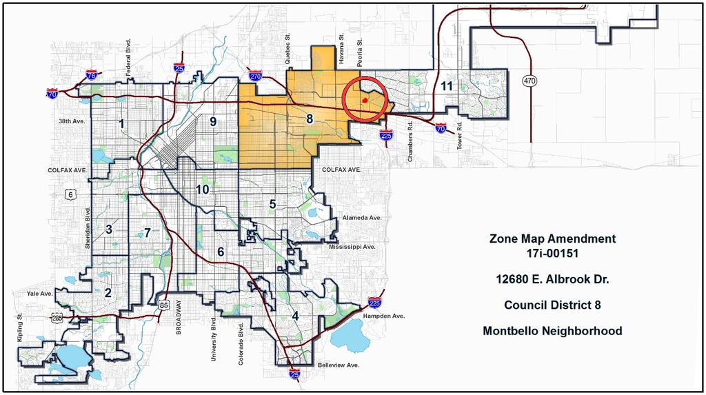
1 TO: Denver City Council Land Use, Transportation, and Infrastructure Committee FROM: Courtney Levingston, Senior City Planner DATE: RE: Official Zoning Map Amendment Application #2017I Staff Report and Recommendation Community Planning and Development Planning Services Based on the criteria for review in the Denver Zoning Code, Staff recommends that the Land Use, Transportation, and Infrastructure Committee move Application #2017I forward for consideration by the full City Council. Request for Rezoning 201 W. Colfax Ave., Dept. 205 Denver, CO p: f: Address: Neighborhood/Council District: Montbello / Council District 8 RNOs: Montbello 20/20, Opportunity Corridor Coalition of United Residents, Northern Corridor Coalition, Montbello Neighborhood Improvement Association, Denver Neighborhood Association, Inc., Inter-Neighborhood Cooperation Area of Property: 5.52 acres (240,566 square feet) Current Zoning: S-MX-12 Proposed Zoning: OS-A Property Owner(s): City and County of Denver Owner Representative: Mark Tabor, Parks and Recreation Summary of Rezoning Request The property is in the Montbello statistical neighborhood, east of Peoria Street. It is comprised of one undeveloped parcel. The City and County of Denver owns the property and it is currently under construction for a public park, with plans for a future environmental education center when funds become available. The City (via Parks and Recreation Department) acquired the property from the Trust for Public Land in December 2014 with the intention of a future public park and environmental education center owned by the City but developed and operated by Environmental Learning for Kids (ELK) under a lease executed simultaneously with the purchase. The OS-A (Open Space Public Parks) zone district is intended for parks owned, operated, or leased by the City and managed by the Department of Parks and Recreation. Further details of the zone district can be found in Article 9 of the Denver Zoning Code (DZC).

2 Page 2
.")
3 Page 3 Existing Context The property is located north of 46 th Ave., east of Peoria Street in the Montbello statistical neighborhood. The area to the south is industrial. The area to the north is characterized as multi-unit residential along Albrook Dr. and a variety of residential and civic uses (Denver Fire Station and Public Library). Directly surrounding the subject property is multi-unit residential, institutional (Denver Health) to the west, and commercial/retail to the east. The site is served by RTD bus service routes 42 and 45 along Albrook Dr. Currently, there is no access to the site because it is under construction. Future access will be shared with the abutting Denver Health property to the west from Albrook Dr. The following table summarizes the existing context proximate to the subject site: Site North South East West Existing Zoning S-MX-12 R-3 UO-3 B-4 w/ waivers UO-1, UO-2 S-MX-12 UO-1, UO-2, OS-A S-MX-12, B-4 w/ waivers UO-1, UO-2, B-8 UO-1, UO-2 Existing Land Uses Undeveloped Multi-unit residential Warehouse Commercial retail clinic, detention pond, commercial /retail Existing Building Form/Scale None 2 story brick multi-unit building 3 story industrial warehouse 1 story brick commercial-style buildings 1 story brick commercial-style buildings Existing Block, Lot, Street Pattern Irregular street grid with large blocks. Surrounding block shapes are inconsistent. Vehicle parking around buildings in surface lots. Connections within blocks provided by interior drives accessed from the street.

4 Page 4 Zoning Map 1. Existing Zoning The existing zoning on the subject property is S-MX-12, which stands for Suburban Mixed Use 12 stories. The S-MX-12 zone district is intended to promote safe, active, pedestrian scaled, diverse areas and enhance the convenience and ease of walking, shopping and public gathering within and around the city s neighborhoods. S-MX-12 applies to areas served primarily by major arterial streets where a building scale of 1 to 12 stories is desired. DZC Section sets forth the Primary Building Form standards for the S- MX-12 zone district. For additional details on the zone district, please see DZC Article 3.

5 Page 5 Existing Land Use Map 2. Existing Land Use Map As illustrated above, existing land uses in the area bounded by Albrook Dr. to the north, 46 th Ave. to the south and Peoria St. to the west are primarily commercial/retail with a few vacant properties and auxiliary parking. The abutting vacant property to the west of the subject parcel is a privately-owned extended detention basin serving flows from the industrial properties to the south. The vacant property at the southeast corner of Peoria St. and Albrook Dr. is a private water quality pond serving stormwater runoff from the surrounding commercial properties. The property shown as parking was the former RTD Montbello park-n-ride, closed in early The two vacant properties to the west across Peoria St. are undeveloped commercial/retail pad sites. The vacant site on Albrook Dr. east of 46 th Ave. is currently undeveloped, however there is a recently approved site plan with a limited custom manufacturing, assembly and fabrication use proposed.


 View of site from")
6 Page 6 3. Existing Building Form and Scale The existing building form and scale of the subject site and adjacent properties are shown in the images below. Aerial view of subject site and surrounding properties (source: Google Maps) View of site from Albrook Dr. looking south View of site from 46 th Ave. looking north


7 Page 7 Multi-unit residential north of site Industrial properties south of site Commercial properties east of site. View is looking west from intersection of Albrook Dr. and 46 th Ave. (source: Google Maps) Stormwater detention basin abutting the southwest portion subject site. View from 46 th Ave. Clinic to the west of subject site. View from Albrook Dr. looking west.
 Summary of City Agency Referral Comments As part of the DZC review process, the rezoning application is referred to potentially affected city agencies and departments for")
8 Page 8 Commercial development to the west of site looking northeast from Peoria St. (source: Google Maps) Summary of City Agency Referral Comments As part of the DZC review process, the rezoning application is referred to potentially affected city agencies and departments for comment. A summary of agency referral responses follows: Assessor: Approved No Comments. Asset Management: Approved- No Comments. Denver Public Schools: Approved - No Comments. Public Health and Environment: Approved See Comments. DDPHE is not aware of environmental concerns on the property and concurs with the rezoning request. General Notes: Most of Colorado is high risk for radon, a naturally occurring radioactive gas. Due to concern for potential radon gas intrusion into buildings, DEH suggests installation of a radon mitigation system in structures planned for human occupation or frequent use. It may be more cost effective to install a radon system during new construction rather than after construction is complete. If renovating or demolishing existing structures, there may be a concern of disturbing regulated materials that contain asbestos or lead-based paint. Materials containing asbestos or lead-based paint should be managed in accordance with applicable federal, state and local regulations. The Denver Air Pollution Control Ordinance (Chapter 4- Denver Revised Municipal Code) specifies that contractors shall take reasonable measures to prevent particulate matter from becoming airborne and to prevent the visible discharge of fugitive particulate emissions beyond the property on which the emissions originate. The measures taken must be effective in the control of fugitive particulate emissions at all times on the site, including periods of inactivity such as evenings, weekends, and holidays. Denver s Noise Ordinance (Chapter 36 Noise Control, Denver Revised Municipal Code) identifies allowable levels of noise. Properties undergoing Re-Zoning may change the acoustic environment but must maintain compliance with the Noise Ordinance. Compliance with the Noise Ordinance is based on the status of the receptor property (for example, adjacent Residential receptors), and not the status of the noise-generating property. Violations of the Noise Ordinance commonly
9 Page 9 result from, but are not limited to, the operation or improper placement of HV/AC units, generators, and loading docks. Construction noise is exempted from the Noise Ordinance during the following hours, 7am 9pm (Mon Fri) and 8am 5pm (Sat & Sun). Variances for nighttime work are allowed, but the variance approval process requires 2 to 3 months. For variance requests or questions related to the Noise Ordinance, please contact Paul Riedesel, Denver Environmental Health ( ). Scope & Limitations: DEH performed a limited search for information known to DEH regarding environmental conditions at the subject site. This review was not intended to conform to ASTM standard practice for Phase I site assessments, nor was it designed to identify all potential environmental conditions. In addition, the review was not intended to assess environmental conditions for any potential right-of-way or easement conveyance process. The City and County of Denver provides no representations or warranties regarding the accuracy, reliability, or completeness of the information provided. GIS: Approved No Comments. Public Works - ROW City Surveyor: Approved No Comments. Development Services Transportation: Approved No Comments. Development Services Wastewater: Approved No Comments. Development Services Project Coordination: Approved; See Comments There is already a completed Site Development Plan for this property. This was done under the existing zone district regulations. The project was phased with the "park" work being done first and the building to follow when funds were available. Development Services Fire Prevention: Approved No Comments Office of Economic Development: Approved No Comments City Attorney s Office: Approved No Comments
10 Page 10 Public Review Process The public process for the proposed rezoning is summarized below: CPD informational notice of receipt of the rezoning application to all affected members of City Council and registered neighborhood organizations: Property legally posted for a period of 15 days and CPD written notice of the Planning Board public hearing sent to all affected members of City Council, property owners and registered neighborhood organizations: Planning Board public hearing, voted unanimously (8:0) to recommend approval CPD written notice of the Land Use, Transportation and Infrastructure Committee meeting sent to all affected members of City Council and registered neighborhood organizations, at least ten working days before the meeting: Land Use, Transportation and Infrastructure Committee of the City Council: 5/9/2017 6/25/2018 7/11/2018 7/16/2018 7/31/2018 Property legally posted for a period of 21 days and CPD written notice of the City Council public hearing sent to all affected members of TBD City Council and registered neighborhood organizations: City Council Public Hearing (tentative): 9/10/2018 Registered Neighborhood Organizations (RNOs) o The RNOs identified on page 1 of this report were notified of this application. o As of the date of this staff report, no RNO comments have been received. Planning Board Planning Board voted unanimously to recommend approval of the proposed rezoning to OS-A. Other Public Comment As of the date of this staff report, no public comments have been received.
11 Page 11 Criteria for Review / Staff Evaluation The criteria for review of this rezoning application are found in DZC, Sections and , as follows: DZC Section Consistency with Adopted Plans 2. Uniformity of District Regulations and Restrictions 3. Public Health, Safety and General Welfare DZC Section Justifying Circumstances 2. Consistency with Neighborhood Context Description, Zone District Purpose and Intent Statements 1. Consistency with Adopted Plans The following adopted plans apply to this property: Denver Comprehensive Plan (2000) Parks Game Plan (2003) Blueprint Denver (2002) Montbello/Green Valley Ranch Neighborhood Plan (1991) Denver Comprehensive Plan (2000) This request is consistent with several Denver Comprehensive Plan strategies. Relevant strategies from the Denver Comprehensive Plan include: Environmental Sustainability Strategy 2-G Preserve and restore, wherever possible, natural habitat for wildlife and plants native to the region (p. 40). Environmental Sustainability Strategy 4-C Respect, conserve and expand wildlife habitat, watersheds, open space and other natural resources (p. 41). Denver s Legacies Strategy 9-B Integrate sufficient open space and recreational amenities into large-scale development plans (p. 102). Environmental Stewardship Strategy 12-B Continue to encourage residents sense of stewardship for their parks though environmental education and volunteer maintenance programs, with special emphasis on youth (p. 104). Recreation Strategy 13-B Coordinate with DPS and community-based organizations to expand recreation opportunities and after-school programs throughout the city (p. 104). The proposed OS-A zone district will ensure continued use for parks, open space, recreation, and related supporting uses. Denver Parks and Recreation Game Plan (2003) Game Plan is the strategic master plan for Denver Parks and Recreation and (like Blueprint Denver) is an adopted supplement to the Denver Comprehensive Plan. The request to rezone the property to the OS-A district is consistent with the Game Plan s vision, policies and strategies, including: Safe, accessible and flexible open spaces located within ½ mile of every home (p. 32). The Game Plan describes a number of amenities that could be in the city s open spaces, which include passive recreation, learning landscapes, and natural open space with opportunities for wildlife. Encourage a variety of public spaces so residents have choices (p. 36).
.")
12 Page 12 Strengthen partnerships with nonprofits working to increase types and availability of open space (p. 42). Reach more people and create efficiencies through innovative partnerships with other recreation providers (p. 48). Increase Denver Parks and Recreation s ability to provide more programs outside the walls by strengthening existing programs, such as community recreation, outdoor recreation, special needs and service-based learning. Expanding recreation programs to park-based education, cultural and social programs (p. 48). Engage the public, increase stewardship and volunteerism, build partnerships that encourage advocacy and additional financial resources and respond to diverse community needs (p. 104). By rezoning the property to OS-A, there will be increased flexibility to support the nonprofit partnership with Environmental Learning for Kids (ELK), ELK s education and community center, and the open space use on city owned property. The rezoning to OS-A is also consistent with the Game Plan. Blueprint Denver (2002) According to the 2002 Plan Map adopted in Blueprint Denver, this site has a concept land use of Town Center and is located in an Area of Stability Blueprint Denver Future Land Use Map Future Land Use Blueprint Denver describes Town Centers as similar to neighborhood centers but meet a larger variety of shopping, entertainment, service and employment needs and are large enough to serve several neighborhoods Urban design features such as plazas, landscaping, small parks and civic features contribute to making these places focal points of community activity (pg. 43). The subject property is part of the larger area all designated as a town center. The proposed map amendment supports the
13 Page 13 Blueprint Denver Town Center concept land use designation by integrating a park with community center activity into the larger town center. Area of Stability As noted above, the 2002 Plan Map from Blueprint Denver designates the subject site and immediately surrounding area as an Area of Stability. In general, the goal for Areas of Stability is to identify and maintain the character of an area while accommodating some new development and redevelopment (p. 120). In some cases, it may be appropriate to change the zoning in an Area of Stability to create a better match between existing land uses and the zoning (p. 124). The proposed map amendment creates a better match between zoning and the existing city-owned park/open space land use. It is consistent with Blueprint Denver s Area of Stability recommendations. Street Classifications Albrook Dr. is identified in Blueprint Denver as a Mixed Use Collector street. Collectors are designed to provide a greater balance between mobility and land access within residential, commercial, and industrial areas. The makeup of a collector street largely depends on the density, size and type of nearby buildings. Posted speed limits on collector streets generally range from 25 to 35 miles per hour. (p. 51). E. 46th Avenue is identified in Blueprint Denver as an Undesignated-Local street. Blueprint Denver states the design features of local streets are influenced less by traffic volumes and are tailored more to providing local access. Mobility on local streets is typically incidental and involves relatively short trips at lower speeds to and from other streets (p. 51). The educational and community center and open space park allowed by OS-A can be suitable along such streets, so the proposed rezoning is consistent with the Blueprint Denver street classification. Small Area Plan: Montbello/Green Valley Ranch Neighborhood Plan (1991) In 1991, Denver City Council adopted the Montbello/Green Valley Ranch Neighborhood Plan, which applies to the property. The plan provides limited guidance for the requested map amendment, but does contain policies supporting community services, parks and open space. The future land use map encourages rezoning the area to the B-4 zone district from the Former Chapter 59 zoning code. Recommendation LZM-1 states, prohibit vehicle sales, adult businesses, billboards and uses inappropriate at this major entry point to the residential neighborhood. Encourage neighborhood serving retail shops and attractive landscaping along Albrook Dr. street frontage (p. 8). The Montbello/Green Valley Ranch Neighborhood Plan does not specifically preclude park uses as part of a vibrant commercial area thus the proposed rezoning is consistent with the plan. 2. Uniformity of District Regulations and Restrictions The proposed rezoning to OS-A will result in the uniform application of zone district building form, use, and design regulations. 3. Public Health, Safety and General Welfare The proposed official map amendment furthers the public health, safety, and general welfare of the city by furthering adopted plans and making the subject property consistent with the purpose of the OS-A zone district. OS-A zoning on the subject property will provide flexibility and better enable maintenance and enhancements for of the open space park and associated uses.
14 Page Justifying Circumstances The rezoning is justified under DZC Section A.4.a, Since the date of the approval of the existing Zone District, there has been a change to such a degree that the proposed rezoning is in the public interest. Such a change may include: Change or changing conditions in a particular area or in the city generally. In December 2014, the property changed ownership as City acquired the property from The Trust for Public Land. This change necessitated a rezoning to OS-A as the OS-A zone district requested is explicitly intended for open space and parks owned, operated, or leased by the City. Moreover, the construction of the Montbello Open Space Park is currently underway as the site development plan was approved under the S-MX-12 zone district. Additionally, the demographics of the Montbello neighborhood have changed and continue to change, with an increasing youth population necessitating the need for additional parks. According to the most recent US Census data, the youth population of Montbello has increase by 18% between 2011 to 2016 as compared to the youth population of Denver overall increasing by 8% over that same period. The office of Childhood Affairs notes in their 2017 Status of Denver s Children report that between 36-42% of children ages 2-17 are overweight or obese, an overall increase since 2014 s report. Additional park land is required to combat the increase childhood obesity rates in Montbello. 5. Consistency with Neighborhood Context Description, Zone District Purpose and Intent Statements Neighborhood Context Description The requested zone district is within the Open Space Context, which consists of all forms of public and private parks and open spaces. The context accommodates sites ranging from very active to completely passive, and from those embedded in a neighborhood to sites that are large enough to stand alone. Active sites may include high use areas such as athletic fields, while passive areas focus on resource protection, trails, and walking. The proposed rezoning is consistent with the neighborhood context and description. Zone District Purpose and Intent The OS-A zone district is intended to protect and preserve public parks owned, operated or leased by the City and managed by the City s Department of Parks and Recreation for park purposes (DZC 9.3.1, 9.3.2). The requested rezoning is consistent with the zone district purpose and intent because it will align the zoning with the city s ownership of the property and its use as a public park. Attachments 1. Application
Land Use, Transportation, and Infrastructure Committee of the Denver City Council FROM: Scott Robinson, Senior City Planner DATE: March 22, 2018 RE:
 Community Planning and Development Planning Services 201 W. Colfax Ave., Dept. 205 Denver, CO 80202 p: 720.865.2915 f: 720.865.3052 www.denvergov.org/cpd TO: Land Use, Transportation, and Infrastructure
Land Use, Transportation, & Infrastructure Committee of the Denver City Council FROM: Chandler Van Schaack, Senior City Planner DATE: July 3, 2018 RE:
 Community Planning and Development Planning Services TO: Land Use, Transportation, & Infrastructure Committee of the Denver City Council FROM: Chandler Van Schaack, Senior City Planner DATE: July 3, 2018
Official Zoning Map Amendment Application #2017I Gaylord Street and York Street Rezoning from U-RH-2.5 to U-RX-3 and U-RX-5
 Community Planning and Development Planning Services 201 W. Colfax Ave., Dept. 205 Denver, CO 80202 p: 720.865.2915 f: 720.865.3052 www.denvergov.org/cpd TO: Denver Planning Board FROM: Elizabeth Weigle,
Land Use, Transportation, and Infrastructure Committee of Denver City Council FROM: Scott Robinson, Senior City Planner DATE: December 6, 2018 RE:
 Community Planning and Development Planning Services 201 W. Colfax Ave., Dept. 205 Denver, CO 80202 p: 720.865.2915 f: 720.865.3052 www.denvergov.org/cpd TO: Land Use, Transportation, and Infrastructure
Staff Report and Recommendation Based on the criteria for review in the Denver Zoning Code, Staff recommends approval for Application #2017I
 TO: Denver Planning Board, Joel Noble, Chair FROM: Theresa Lucero, Senior City Planner DATE: RE: Official Zoning Map Amendment Application #2017I-00163 Staff Report and Recommendation Based on the criteria
Official Zoning Map Amendment Application #2018I-00120
 Community Planning and Development Planning Services 201 W. Colfax Ave., Dept. 205 Denver, CO 80202 p: 720.865.2915 f: 720.865.3052 www.denvergov.org/cpd TO: Denver Planning Board FROM: Scott Robinson,
Official Zoning Map Amendment Application #2017I and 4889 South Quebec Street Rezoning from B-4 with waivers, UO-1, UO-2 to C-MX-20
 Community Planning and Development Planning Services 201 W. Colfax Ave., Dept. 205 Denver, CO 80202 p: 720.865.2915 f: 720.865.3052 www.denvergov.org/cpd TO: Denver Planning Board FROM: Jeff Hirt, Senior
Brad Buchanan, Executive Director, Department of Community Planning and Development
 TO: City Council FROM: Jeff Hirt, Senior City Planner DATE: RE: Official Zoning Map Amendment Application #2017I-00076 3400 Arkins Ct., 3460 Arkins Ct., 1900 35 th St, 1930 35th St., 1950 35 th St Rezoning
Official Zoning Map Amendment Application #2018I-00067
 Community Planning and Development Planning Services 201 W. Colfax Ave., Dept. 205 Denver, CO 80202 p: 720.865.2915 f: 720.865.3052 www.denvergov.org/cpd TO: Denver Planning Board FROM: Courtney Levingston,
Official Zoning Map Amendment Application #2017I-00094
 Community Planning and Development Planning Services 201 W. Colfax Ave., Dept. 205 Denver, CO 80202 p: 720.865.2915 f: 720.865.3052 www.denvergov.org/cpd TO: Denver Planning Board FROM: Scott Robinson,
Official Zoning Map Amendment Application #2017I-00090
 Community Planning and Development Planning Services 201 W. Colfax Ave., Dept. 205 Denver, CO 80202 p: 720.865.2915 f: 720.865.3052 www.denvergov.org/cpd TO: Land Use, Transportation, & Infrastructure
Request for Rezoning. Current Zoning: Proposed Zoning:
 TO: Denver City Council, Neighborhoods and Planning Committee FROM: Theresa Lucero, Senior City Planner DATE: March 31, 2016 RE: Zoning Map Amendment #2015I-00150 Rezoning from M-RX-5 to I-MX-3 Community
Block bounded by Newton St., 17 th Ave., Lowell Blvd., and 16 th Ave.; plus Meade Street (evens only)
") Community Planning and Development Planning Services 201 W. Colfax Ave., Dept. 205 Denver, CO 80202 p: 720.865.2915 f: 720.865.3052 www.denvergov.org/cpd TO: Denver Planning Board FROM: Sara White, AICP,
Community Planning and Development Planning Services 201 W. Colfax Ave., Dept. 205 Denver, CO 80202 p: 720.865.2915 f: 720.865.3052 www.denvergov.org/cpd TO: Denver Planning Board FROM: Sara White, AICP,
Staff Report and Recommendation
 Community Planning and Development Planning Services 201 W. Colfax Ave., Dept. 205 Denver, CO 80202 p: 720.865.2915 f: 720.865.3052 www.denvergov.org/cpd TO: Denver Planning Board FROM: Andrew Webb, Senior
Staff Report and Recommendation Based on the criteria for review in the Denver Zoning Code, Staff recommends approval for application #2017I
 TO: Denver City Council, Land Use, Transportation and Infrastructure Committee FROM: Theresa Lucero, Senior City Planner DATE: RE: Official Zoning Map Amendment Application #2017I-00153 Staff Report and
Based on the criteria for review in the Denver Zoning Code, Staff recommends approval for Application #2018I
 Community Planning and Development Planning Services 201 W. Colfax Ave., Dept. 205 Denver, CO 80202 p: 720.865.2915 f: 720.865.3052 www.denvergov.org/cpd TO: Denver Planning Board FROM: Chandler Van Schaack,
Official Zoning Map Amendment Application #2018I-00095
 Community Planning and Development Planning Services 201 W. Colfax Ave., Dept. 205 Denver, CO 80202 p: 720.865.2915 f: 720.865.3052 www.denvergov.org/cpd TO: Denver Planning Board FROM: Ella Stueve, Senior
To: S-MX-8 AIO, S-MX-8A AIO, S-MX-12 AIO, C-MX-8 AIO, C-MX-12 AIO, and S-CC-5 AIO
 Community Planning and Development Planning Services 201 W. Colfax Ave., Dept. 205 Denver, CO 80202 p: 720.865.2915 f: 720.865.3052 www.denvergov.org/cpd TO: Denver City Council FROM: Curt Upton, Senior
REZONING GUIDE. Zone Map Amendment (Rezoning) - Application. Rezoning Application Page 1 of 3. Return completed form to
 - Application. Rezoning Application Page 1 of 3. Return completed form to") COMMUNITY PLANNING & DEVELOPMENT REZONING GUIDE Rezoning Application Page 1 of 3 Zone Map Amendment (Rezoning) - Application PROPERTY OWNER INFORMATION* PROPERTY OWNER(S) REPRESENTATIVE** CHECK IF POINT
COMMUNITY PLANNING & DEVELOPMENT REZONING GUIDE Rezoning Application Page 1 of 3 Zone Map Amendment (Rezoning) - Application PROPERTY OWNER INFORMATION* PROPERTY OWNER(S) REPRESENTATIVE** CHECK IF POINT
REZONING GUIDE. Zone Map Amendment (Rezoning) - Application. Rezoning Application Page 1 of 3. Return completed form to
 - Application. Rezoning Application Page 1 of 3. Return completed form to") Zone Map Amendment (Rezoning) - Application COMMUNITY PLANNING & DEVELOPMENT REZONING GUIDE Rezoning Application Page 1 of 3 PROPERTY OWNER INFORMATION* CHECK IF POINT OF CONTACT FOR APPLICATION Property
Zone Map Amendment (Rezoning) - Application COMMUNITY PLANNING & DEVELOPMENT REZONING GUIDE Rezoning Application Page 1 of 3 PROPERTY OWNER INFORMATION* CHECK IF POINT OF CONTACT FOR APPLICATION Property
Official Zoning Map Amendment Application #2015I Marion St. Rezoning from U-SU-A1 to U-MX-2x
 Community Planning and Development Planning Services 201 W. Colfax Ave., Dept. 205 Denver, CO 80202 p: 720.865.2915 f: 720.865.3052 www.denvergov.org/cpd TO: Denver City Council FROM: Courtland Hyser,
Telephone AC / 21,960 SF G-MU-3 G-MX-3
 Zone Map Amendment (Rezoning) - Application PROPERTY OWNER INFORMATION* CHECK IF POINT OF CONTACT FOR APPLICATION Property Owner Name Siddhartha Rathod Address City, State, Zip Telephone Email COMMUNITY
Official Zoning Map Amendment Application #2015I N. King Street and 3441 W. 39 th Ave Rezoning from PUD 406 to U-SU-B1
 Community Planning and Development Planning Services 201 W. Colfax Ave., Dept. 205 Denver, CO 80202 p: 720.865.2915 f: 720.865.3052 www.denvergov.org/cpd TO: Neighborhoods and Planning Committee FROM:
REZONING GUIDE. Zone Map Amendment (Rezoning) - Application. Rezoning Application Page 1 of 3. Return completed form to
 - Application. Rezoning Application Page 1 of 3. Return completed form to") Zone Map Amendment (Rezoning) - Application COMMUNITY PLANNING & DEVELOPMENT REZONING GUIDE Rezoning Application Page 1 of 3 PROPERTY OWNER INFORMATION* CHECK IF POINT OF CONTACT FOR APPLICATION Property
Zone Map Amendment (Rezoning) - Application COMMUNITY PLANNING & DEVELOPMENT REZONING GUIDE Rezoning Application Page 1 of 3 PROPERTY OWNER INFORMATION* CHECK IF POINT OF CONTACT FOR APPLICATION Property
City Council Land Use, Transportation, and Infrastructure Committee FROM: Jeff Hirt, Senior City Planner DATE: March 9, 2018 RE:
 TO: City Council Land Use, Transportation, and Infrastructure Committee FROM: Jeff Hirt, Senior City Planner DATE: March 9, 2018 RE: Official Zoning Map Amendment #2015I-00168 Community Planning and Development
REZONING GUIDE. Zone Map Amendment (Rezoning) - Application. Rezoning Application Page 1 of 3. Return completed form to
 - Application. Rezoning Application Page 1 of 3. Return completed form to") Zone Map Amendment (Rezoning) - Application COMMUNITY PLANNING & DEVELOPMENT REZONING GUIDE Rezoning Application Page 1 of 3 PROPERTY OWNER INFORMATION* CHECK IF POINT OF CONTACT FOR APPLICATION Property
Zone Map Amendment (Rezoning) - Application COMMUNITY PLANNING & DEVELOPMENT REZONING GUIDE Rezoning Application Page 1 of 3 PROPERTY OWNER INFORMATION* CHECK IF POINT OF CONTACT FOR APPLICATION Property
REZONING GUIDE. Zone Map Amendment (Rezoning) - Application. Rezoning Application Page 1 of 3. Return completed form to
 - Application. Rezoning Application Page 1 of 3. Return completed form to") COMMUNITY PLANNING & DEVELOPMENT REZONING GUIDE Rezoning Application Page 1 of 3 Zone Map Amendment (Rezoning) - Application PROPERTY OWNER INFORMATION* PROPERTY OWNER(S) REPRESENTATIVE** CHECK IF POINT
COMMUNITY PLANNING & DEVELOPMENT REZONING GUIDE Rezoning Application Page 1 of 3 Zone Map Amendment (Rezoning) - Application PROPERTY OWNER INFORMATION* PROPERTY OWNER(S) REPRESENTATIVE** CHECK IF POINT
PLANNING COMMISSION STAFF REPORT
 PLANNING COMMISSION STAFF REPORT REZONING CASE: RZ-16-001 REPORT DATE: March 8, 2016 CASE NAME: Trailbreak Partners Rezoning PLANNING COMMISSION DATE: March 16, 2016 ADDRESSES OF REZONING PROPOSAL: 5501
SUBDIVISION, PLANNED UNIT DEVELOPMENT, ZONING AMENDMENT, & SIDEWALK WAIVER STAFF REPORT Date: July 19, 2018
 SUBDIVISION, PLANNED UNIT DEVELOPMENT, ZONING AMENDMENT, & SIDEWALK WAIVER STAFF REPORT Date: July 19, 2018 NAME SUBDIVISION NAME LOCATION West Mobile Properties, LLC U.S. Machine Subdivision 556, 566,
Article 3. SUBURBAN (S-) NEIGHBORHOOD CONTEXT
 NEIGHBORHOOD CONTEXT") Article 3. SUBURBAN (S-) NEIGHBORHOOD CONTEXT this page left intentionally blank Contents ARTICLE 3. SUBURBAN (S-) NEIGHBORHOOD CONTEXT DIVISION 3.1 NEIGHBORHOOD CONTEXT DESCRIPTION...3.1-1 Section 3.1.1
Article 3. SUBURBAN (S-) NEIGHBORHOOD CONTEXT this page left intentionally blank Contents ARTICLE 3. SUBURBAN (S-) NEIGHBORHOOD CONTEXT DIVISION 3.1 NEIGHBORHOOD CONTEXT DESCRIPTION...3.1-1 Section 3.1.1
Planning Department Oconee County, Georgia
 Planning Department Oconee County, Georgia STAFF REPORT REZONE CASE #: 6985 DATE: October 31, 2016 STAFF REPORT BY: Andrew C. Stern, Planner APPLICANT NAME: Williams & Associates, Land Planners PC PROPERTY
City of Valdosta Land Development Regulations
 Chapter 206 Section 206-1 Base Zoning Districts Standards for Uses, Structures, and Property Development (B) (C) Principal Uses and Structures. Principal uses and structures permitted in each base zoning
REZONING GUIDE. Zone Map Amendment (Rezoning) - Application. Rezoning Application Page 1 of 3. Return completed form to
 - Application. Rezoning Application Page 1 of 3. Return completed form to") Zone Map Amendment (Rezoning) - Application COMMUNITY PLANNING & DEVELOPMENT REZONING GUIDE Rezoning Application Page 1 of 3 PROPERTY OWNER INFORMATION* CHECK IF POINT OF CONTACT FOR APPLICATION Property
Zone Map Amendment (Rezoning) - Application COMMUNITY PLANNING & DEVELOPMENT REZONING GUIDE Rezoning Application Page 1 of 3 PROPERTY OWNER INFORMATION* CHECK IF POINT OF CONTACT FOR APPLICATION Property
TO: City Council FROM: Jeff Hirt, Senior City Planner DATE: April 19, 2018 RE: Official Zoning Map Amendment #2015I-00168
 Community Planning and Development Planning Services 201 W. Colfax Ave., Dept. 205 Denver, CO 80202 p: 720.865.2915 f: 720.865.3052 www.denvergov.org/cpd TO: City Council FROM: Jeff Hirt, Senior City Planner
HOUSING ELEMENT GOALS, OBJECTIVES, AND POLICIES
 HOUSING ELEMENT GOALS, OBJECTIVES, AND POLICIES GOAL 1: To promote the preservation and development of high-quality, balanced, and diverse housing options for persons of all income levels throughout the
The Planning Commission. DATE: July 19, 2016
 TO: FROM: The Planning Commission MPC Staff DATE: SUBJECT: Petition of Chatham Savannah Authority for the Homeless Cindy Kelley, Agent Saffold Properties L.P. (John Saffold), Owner Aldermanic District:
DZC and DRMC Amendments to Implement 38th and Blake Station Area Height Amendments
 DZC and DRMC Amendments to Implement 38th and Blake Station Area Height Amendments DZC Text Amendment #2 to establish River North Design Overlay (DO-7) / 38 th and Blake Incentive Overlay (IO-1) (CB18-0016)
Bylaw No , being "Official Community Plan Bylaw, 2016" Schedule "A" DRAFT
 Bylaw No. 2600-2016, being "Official Community Plan Bylaw, 2016" Schedule "A" Urban Structure + Growth Plan Urban Structure Land use and growth management are among the most powerful policy tools at the
PLANNED UNIT DEVELOPMENT & SUBDIVISION STAFF REPORT Date: April 18, 2019
 PLANNED UNIT DEVELOPMENT & SUBDIVISION STAFF REPORT Date: April 18, 2019 DEVELOPMENT NAME SUBDIVISION NAME Springhill Village Subdivision Springhill Village Subdivision LOCATION 4350, 4354, 4356, 4358,
PC Staff Report 11/18/2013 Z Item No. 1-1
 Z-13-00401 Item No. 1-1 PLANNING COMMISSION REPORT Regular Agenda - Public Hearing Item PC Staff Report 11/18/2013 ITEM NO. 1: Z-13-00401 IG (General Industrial) District TO CS (Strip Commercial) District;
Chapter 10: Implementation
 Chapter 10: Introduction Once the Comprehensive Plan has been adopted by the City of Oakdale, the City can begin to implement the goals and strategies to make this vision a reality. This chapter will set
MPC STAFF REPORT REZONING MAP AMENDMENT ALDERMANIC DISTRICT 1 COUNTY COMMISSION DISTRICT 5 April 3, 2013 MPC FILE NUMBER.
 MPC STAFF REPORT REZONING MAP AMENDMENT ALDERMANIC DISTRICT 1 COUNTY COMMISSION DISTRICT 5 April 3, 2013 MPC FILE NUMBER. 13-000929-ZA REZONING SUMMARY Report Status Initial Report Petitioner/Property
Public Review of the Slot Home Text Amendment
 Public Review of the Slot Home Text Amendment The proposed amendments to the Denver Zoning Code have been informed by the Slot Home Strategy Report. This document has been developed out of a robust process
THE WHEELER BUILDING SUBDIVISION
 THE WHEELER BUILDING SUBDIVISION Engineering Comments: FINAL PLAT COMMENTS (should be addressed prior to submitting the FINAL PLAT for review and/or signature by the City Engineer): A. Provide all of the
Representative Name. Address. City, State, Zip. Telephone.
 COMMUNITY PLANNING & DEVELOPMENT ~~DENVER... THE MILE HIGH CITY REZONING GUIDE Zone Map Amendment (Rezoning)- Application Rezoning Application Page 1 of 3 Property Owner Name Philip M. Falco Address 730
Rapid City Planning Commission Conditional Use Permit Project Report
 Rapid City Planning Commission Conditional Use Permit Project Report September 21, 2017 Applicant Request(s) Case # 17UR020 Conditional Use Permit to allow a mini-storage facility Companion Case(s) # Item
ZONING AMENDMENT & SUBDIVISION STAFF REPORT Date: November 3, 2016
 ZONING AMENDMENT & SUBDIVISION STAFF REPORT Date: November 3, 2016 APPLICANT NAME SUBDIVISION NAME David Shumer 5955 Airport Subdivision CITY COUNCIL DISTRICT District 6 5955 Airport Boulevard, 754 Linlen
CITY OF TYLER PLANNING AND ZONING COMMISSION STAFF COMMENTS
 CITY OF TYLER PLANNING AND ZONING COMMISSION STAFF COMMENTS Date: September 4, 2018 Subject: PD18-019 ZB3 PROPERTIES, LLC (2469 EARL CAMPBELL PARKWAY) Request that the Planning and Zoning Commission consider
Marcel Williams, MPC Project Planner
 TO: FROM: The Planning Commission MPC Staff DATE: SUBJECT: Petition to Rezone Property Heath Shelton, Owner Jay Maupin, Agent 2026 Habersham Street Aldermanic District: 2, Bill Durrence County Commission
David J. Gellner, AICP, Principal Planner; (801) ; Zoning Map Amendment
 ; Zoning Map Amendment") Staff Report PLANNING DIVISION DEPARTMENT of COMMUNITY and NEIGHBORHOODS To: From: Salt Lake City Planning Commission David J. Gellner, AICP, Principal Planner; (801) 535-6107; david.gellner@slcgov.com
Staff Report PLANNING DIVISION DEPARTMENT of COMMUNITY and NEIGHBORHOODS To: From: Salt Lake City Planning Commission David J. Gellner, AICP, Principal Planner; (801) 535-6107; david.gellner@slcgov.com
PLANNING COMMISSION STAFF REPORT
 PLANNING COMMISSION STAFF REPORT REZONING CASE: RZ-15-002 REPORT DATE: January 26, 2016 CASE NAME: Thursday Lunch Club Rezoning PLANNING COMMISSION DATE: February 17, 2016 ADDRESS OF REZONING PROPOSAL:
RC ; Reclassification The Garrison at Stafford Proffer Amendment (formerly Stafford Village Center)
") Board of Supervisors Robert Bob Thomas, Jr., Chairman Laura A. Sellers, Vice Chairman Meg Bohmke Jack R. Cavalier Wendy E. Maurer Paul V. Milde, III Gary F. Snellings Anthony J. Romanello, ICMA CM County
Board of Supervisors Robert Bob Thomas, Jr., Chairman Laura A. Sellers, Vice Chairman Meg Bohmke Jack R. Cavalier Wendy E. Maurer Paul V. Milde, III Gary F. Snellings Anthony J. Romanello, ICMA CM County
Glades County Staff Report and Recommendation Unified Staff Report for Small Scale Plan Amendment and Rezoning
 Glades County Staff Report and Recommendation Unified Staff Report for Small Scale Plan Amendment and Rezoning CASE NUMBERS: COMP17-02 and RZ17-02 DATE of STAFF REPORT: May 1, 2017 CASE TYPE: Application
REPORT OF THE PLANNING AND DEVELOPMENT DEPARTMENT FOR APPLICATION FOR REZONING ORDINANCE TO PLANNED UNIT DEVELOPMENT AUGUST 20, 2015
 BEL REPORT OF THE PLANNING AND DEVELOPMENT DEPARTMENT FOR APPLICATION FOR REZONING ORDINANCE TO PLANNED UNIT DEVELOPMENT AUGUST 20, 2015 The Planning and Development Department hereby forwards to the Planning
DEVELOPMENT DEPARTMENT STAFF REPORT STAFF REPORT EASTSIDE CHAMBLEE LINK DCI
 DEVELOPMENT DEPARTMENT STAFF REPORT Public Hearing Date: April 12, 2018 Item #: PZ-2018-248 STAFF REPORT EASTSIDE CHAMBLEE LINK DCI Request: Development of Community Compact (DCI), ten concurrent variances,
TULSA PARK ESTATES SUBDIVISION, RESUBDIVISION OF LOT 6
 TULSA PARK ESTATES SUBDIVISION, RESUBDIVISION OF LOT 6 Engineering Comments: FINAL PLAT COMMENTS (should be addressed prior to submitting the FINAL PLAT for review and/or signature by the City Engineer):
Krisana Park S Edison Way. Conservation Overlay (Proposed) Preapp 03/04/15
 Preapp 03/04/15") Krisana Park S Edison Way Conservation Overlay (Proposed) Preapp 03/04/15 Request Private property - Both sides of S. Edison Way: 4.25 acres 24 Single Unit Dwellings Existing Context Zoning Existing Zoning:
Krisana Park S Edison Way Conservation Overlay (Proposed) Preapp 03/04/15 Request Private property - Both sides of S. Edison Way: 4.25 acres 24 Single Unit Dwellings Existing Context Zoning Existing Zoning:
ZONING AMENDMENT & SUBDIVISION STAFF REPORT Date: July 3, 2014
 ZONING AMENDMENT & SUBDIVISION STAFF REPORT Date: July 3, 2014 APPLICANT NAME SUBDIVISION NAME LOCATION Georgia Crown Distributing Subdivision Georgia Crown Distributing Subdivision Southwest corner of
STAFF REPORT. January 25, North York Community Council. Director, Community Planning, North District
 STAFF REPORT January 25, 2005 To: From: Subject: Purpose: North York Community Council Director, Community Planning, North District Refusal Report OPA & Rezoning Application 04 194214 NNY 33 OZ Applicant:
Rapid City Planning Commission
 Rapid City Planning Commission Initial Planned Development Overlay Project Report March 9, 2017 Item #15 Applicant Request(s) Case # 17PD007 Initial Planned Development Overlay to allow a residential development
Financial Impact Statement There are no immediate financial impacts associated with the adoption of this report.
 STAFF REPORT Planning and Development Department Subject: Application by RYC Property to rezone a portion of lands on John Murray Dr. and Megan Lynn Dr. from R2 to R3 and to enter into a Development Agreement
REZONING GUIDE. Zone Map Amendment (Rezoning) - Application. Rezoning Application Page 1 of 3. Return completed form to
 - Application. Rezoning Application Page 1 of 3. Return completed form to") Zone Map Amendment (Rezoning) - Application COMMUNITY PLANNING & DEVELOPMENT REZONING GUIDE Rezoning Application Page 1 of 3 PROPERTY OWNER INFORMATION* CHECK IF POINT OF CONTACT FOR APPLICATION Property
Zone Map Amendment (Rezoning) - Application COMMUNITY PLANNING & DEVELOPMENT REZONING GUIDE Rezoning Application Page 1 of 3 PROPERTY OWNER INFORMATION* CHECK IF POINT OF CONTACT FOR APPLICATION Property
ZONING AMENDMENT & SUBDIVISION STAFF REPORT Date: March 1, 2018
 #13 SUB-000406-2018 & ZON-000407-2018 ZONING AMENDMENT & SUBDIVISION STAFF REPORT Date: March 1, 2018 NAME SUBDIVISION NAME LOCATION Creekside @ Kooiman Dairy Creekside @ Kooiman Dairy Subdivision (South
CITY OF NORTH LAS VEGAS MEMORANDUM
 CITY OF NORTH LAS VEGAS MEMORANDUM TO: FROM: SUBJECT: Planning Commission Community Development and Compliance Department # 28 ) AMP-03-15; Coleman Airpark II & III - Comprehensive Plan Amendment (Public
The impact of changing demographics on Denver and what it means for the future
 6400 acres 10 neighborhoods 65,000 residents 22,000 households 3 city council districts The impact of changing demographics on Denver and what it means for the future 6 June 2017 WDRC mission The mission
Planning & Zoning Commission
 Planning & Zoning Commission Planning & Development Department August 14, 01 Zoning Map Amendment MAP-1-0001 (Bay View Section 4) Request Rezone approximately 1.19 acres from OS (Open Space) to RSF- (Residential
DIVISION 1.3 OFFICIAL ZONING MAP
 Article 1. General Provisions Division 1.3 Official Zone Map DIVISION 1.3 OFFICIAL ZONING MAP SECTION 1.3.1 ADOPTION OF OFFICIAL MAP The digital maps created and maintained by the Department of Community
TOWN OF ORO VALLEY PLANNING & ZONING COMMISSION MEETING DATE: December 6, 2011
 PLANNING & ZONING COMMISSION MEETING DATE: December 6, 2011 TO: FROM: SUBJECT: PLANNING & ZONING COMMISSION Matt Michels, Senior Planner mmichels@orovalleyaz.gov; tel. 229-4822 Public Hearing: Rancho de
PALM BEACH COUNTY PLANNING, ZONING AND BUILDING DEPARTMENT ZONING DIVISION ZONING COMMISSION VARIANCE STAFF REPORT 06/05/2014
 PALM BEACH COUNTY PLANNING, ZONING AND BUILDING DEPARTMENT ZONING DIVISION ZONING COMMISSION VARIANCE STAFF REPORT 06/05/2014 APPLICATION NO. ZV-2013-03120 CODE SECTION REQUIRED PROPOSED VARIANCE (V1)
WESTMINSTER PARK SUBDIVISION
 WESTMINSTER PARK SUBDIVISION Engineering Comments: FINAL PLAT COMMENTS (should be addressed prior to submitting the FINAL PLAT for review and/or signature by the City Engineer): A. Provide all of the required
770 BROOKFIELD ROAD Site Plan Control Atlantis Investments November 2017
 770 BROOKFIELD ROAD Site Plan Control Atlantis Investments November 2017 Prepared for: Atlantis Investments Inc. Prepared by: Fotenn Planning + Design 223 McLeod Street Ottawa, ON K2P 0Z8 fotenn.com October
TOTTENHAM SECONDARY PLAN
 TOTTENHAM SECONDARY PLAN AMENDMENT NO. 11 TO THE OFFICIAL PLAN OF THE TOWN OF NEW TECUMSETH The following text and schedules to the Official Plan of the Town of New Tecumseth constitute Amendment No. 11
DEVELOPMENT DEPARTMENT STAFF REPORT DRESDEN HEIGHTS PHASE II DCI
 DEVELOPMENT DEPARTMENT Meeting Date: January 10, 2019 Item #: PZ2019-393 Project Name: Applicant and Owner: Proposed Development: Requests: STAFF REPORT DRESDEN HEIGHTS PHASE II DCI Dresden Heights Phase
this page left intentionally blank DENVER ZONING CODE
 Article 1. GENERAL PROVISIONS this page left intentionally blank Contents ARTICLE 1. GENERAL PROVISIONS DIVISION 1.1 GENERAL...1.1-1 Section 1.1.1 Purpose...1.1-1 Section 1.1.2 Intent...1.1-1 Section 1.1.3
Amendments to Chapter proposed by the Assembly Title 21 Committee
 Amendments to Chapter 21.04 proposed by the Assembly Title 21 Committee All page numbers refer to the S version. PZC recommended additions are underlined. PZC recommended deletions are in [BRACKETS AND
ZONING AMENDMENT, PLANNED UNIT DEVELOPMENT & SUBDIVISION STAFF REPORT Date: August 8, 2013
 ZONING AMENDMENT, PLANNED UNIT DEVELOPMENT & SUBDIVISION STAFF REPORT Date: August 8, 2013 NAME SUBDIVISION NAME PV-Magnolia, LLC Twelve Trees Subdivision LOCATION 2860, 2862 and 2866 Pleasant Valley Road
2017I September 7, 2018 fees waived per
 Review Criteria for 3610 and 3612 North Clay Street from PUD #504 to U-TU-B. 1. Consistency with Adopted Plans: The following adopted plans apply to this property: Denver Comprehensive Plan 2000 Blueprint
Town of Cary, North Carolina Rezoning Staff Report 12-REZ-27 Morris Branch Town Council Public Hearing January 24, 2013
 Town of Cary, North Carolina Rezoning Staff Report 12-REZ-27 Morris Branch Town Council Public Hearing January 24, 2013 REQUEST To amend the Town of Cary Official Zoning Map to rezone approximately 9.0
LITTLE MOUNTAIN ADJACENT AREA REZONING POLICY
 LITTLE MOUNTAIN ADJACENT AREA REZONING POLICY JANUARY 2013 CONTENTS 1.0 INTENT & PRINCIPLES...1 2.0 APPLICATION...2 3.0 HOUSING TYPES, HEIGHT & DENSITY POLICIES...3 3.1 LOW TO MID-RISE APARTMENT POLICIES...4
Paul D. Ralph, BES, RPP, MCIP, Commissioner, Development Services Department
 Public Report To: From: Report Number: Development Services Committee Paul D. Ralph, BES, RPP, MCIP, Commissioner, Development Services Department DS-16-50 Date of Report: April 14, 2016 Date of Meeting:
TOOELE COUNTY LAND USE ORDINANCE CHAPTER 31 Page 1
 CHAPTER 31 PLANNED COMMUNITY ZONE (P-C) Section 31-1 Definitions. 31-2 Purpose. 31-3 Land use districts. 31-4 P-C zone area minimum requirements. 31-5 Permitted uses. 31-6 Conditional uses. 31-7 Planning
BROADWAY THREE NOTCH ROAD SUBDIVISION
 # 3 SUB-000803-2018 BROADWAY THREE NOTCH ROAD SUBDIVISION Engineering Comments: FINAL PLAT COMMENTS (should be addressed prior to submitting the FINAL PLAT for review and/or signature by the City Engineer):
PLANNING COMMISSION REPORT Regular Agenda Public Hearing Item
 PC Staff Report 11/12/12 Item No. 2B- 1 PLANNING COMMISSION REPORT Regular Agenda Public Hearing Item ITEM NO. 2B: A TO GPI; 110 ACRES; E OF K-10 & N OF W 6 TH ST (MKM) : Consider a request to rezone approximately
CITY OF FORT COLLINS NATURAL AREAS AND CONSERVED LANDS EASEMENT POLICY
 CITY OF FORT COLLINS NATURAL AREAS AND CONSERVED LANDS EASEMENT POLICY Adopted January 3, 2012 PURPOSE: The purpose of the policy statement is to clarify the policies and procedures of the City of Fort
7 August 14, 2013 Public Hearing
 7 August 14, 2013 Public Hearing APPLICANT & OWNER: STAFF PLANNER: Stephen J. White REQUEST: Conditional Use Permit (motor vehicle sales) ADDRESS / DESCRIPTION: 4717 Hollis Road / 4740 Shore Drive GPIN:
PORT PHILLIP PLANNING SCHEME. Condition
 SCHEDULE 1 TO THE CAPITAL CITY ZONE Shown on the planning scheme map as CCZ1. FISHERMANS BEND URBAN RENEWAL AREA Purpose To use and develop the Fishermans Bend Urban Renewal Area generally in accordance
Bowie Marketplace Residential Detailed Site Plan Statement of Justification January 13, 2017 Revised February 2, 1017
 Bowie Marketplace Residential Detailed Site Plan Statement of Justification January 13, 2017 Revised February 2, 1017 Submitted on behalf of: BE Bowie LLC 5410 Edson Lane, Suite 220 Rockville, MD 20852
PLANNED UNIT DEVELOPMENT & SUBDIVISION STAFF REPORT Date: November 17, 2016
 PLANNED UNIT DEVELOPMENT & SUBDIVISION STAFF REPORT Date: November 17, 2016 DEVELOPMENT NAME SUBDIVISION NAME LOCATION Autonation Ford of Mobile Autonation Ford of Mobile Subdivision 901, 909, and 925
Town of Cary, North Carolina Rezoning Staff Report 14-REZ-31 Cary Park PDD Amendment (Waterford II) Town Council Meeting January 15, 2015
 Town Council Meeting January 15, 2015") Town of Cary, North Carolina Rezoning Staff Report 14-REZ-31 Cary Park PDD Amendment (Waterford II) Town Council Meeting January 15, 2015 REQUEST To amend the Town of Cary Official Zoning Map by amending
Town of Cary, North Carolina Rezoning Staff Report 14-REZ-31 Cary Park PDD Amendment (Waterford II) Town Council Meeting January 15, 2015 REQUEST To amend the Town of Cary Official Zoning Map by amending
PLANNING COMMISSION REPORT Regular Agenda - Public Hearing Item
 Z-15-00469 Item No. 6A- 1 PLANNING COMMISSION REPORT Regular Agenda - Public Hearing Item PC Staff Report 11/16/15 ITEM NO. 6A GPI, RM12, & RS40 TO RM12; 14.756 ACRES; 5200 & 5300 CLINTON PKWY (SLD) Z-15-00469:
PLANNING COMMISSION PUBLIC HEARING STAFF REPORT ZRTD FAIRFAX MARBLE & GRANITE
 Date of Hearing: PLANNING COMMISSION PUBLIC HEARING STAFF REPORT SUBJECT: ELECTION DISTRICT: ZRTD-2016-0009 FAIRFAX MARBLE & GRANITE Broad Run CRITICAL ACTION DATE: September 27, 2017 STAFF CONTACTS: APPLICANT:
Planning Rationale in Support of an Application for Plan of Subdivision and Zoning By-Law Amendment
 Planning Rationale in Support of an Application for Plan of Subdivision and Zoning By-Law Amendment The Kilmorie Development 21 Withrow Avenue City of Ottawa Prepared by: Holzman Consultants Inc. Land
DISCUSSION DRAFT 1 INTRODUCTORY PROVISIONS
 1 INTRODUCTORY PROVISIONS 1.1 GENERAL...3 Title 3 Authority 3 Applicability 3 Purpose 3 Regulatory Scope 4 Compliance 4 Fines and Penalties 4 Conflicting Provisions 5 Meaning & Intent 5 Text & Graphics
CITY COUNCIL STUDY SESSION MEMORANDUM
 City and County of Broomfield, Colorado To: From: Prepared by: Owner Applicant Property Size Property Location: CITY COUNCIL STUDY SESSION MEMORANDUM Mayor and City Council Charles Ozaki, City and County
Draft Model Access Management Overlay Ordinance
 Draft Model Access Management Overlay Ordinance This model was developed using the City of Hutchinson and the Trunk Highway 7 corridor. The basic provisions of this model may be adopted by any jurisdiction
BOARD OF ZONING ADJUSTMENT STAFF REPORT Date: April 1, 2019
 BOARD OF ZONING ADJUSTMENT STAFF REPORT Date: April 1, 2019 CASE NUMBER 6246/ 4940 APPLICANT NAME LOCATION VARIANCE REQUEST ZONING ORDINANCE REQUIREMENT ZONING AREA OF PROPERTY Volunteers of America 6500
Chapter 5: Testing the Vision. Where is residential growth most likely to occur in the District? Chapter 5: Testing the Vision
 Chapter 5: Testing the Vision The East Anchorage Vision, and the subsequent strategies and actions set forth by the Plan are not merely conceptual. They are based on critical analyses that considered how
Planning Rationale. 224 Cooper Street
 Submitted by: Robertson Martin Architects Tel 613.567.1361 Fax 613.567.9462 216 Pretoria Ave, Ottawa, Ontario, K1S 1X2 Planning Rationale 224 Cooper Street Planning Rationale Application to City of Ottawa
Planning Justification Report
 Planning Justification Report Kellogg s Lands City of London E&E McLaughlin Ltd. June 14, 2017 Zelinka Priamo Ltd. Page i TABLE OF CONTENTS Page No. 1.0 2.0 2.1 2.2 3.0 4.0 5.0 5.1 5.2 5.3 5.4 5.5 5.6
Town of Jamestown Planning Board Zoning Staff Report June 14, 2010
 Town of Jamestown Planning Board Zoning Staff Report June 14, 2010 The information provided in this staff report has been included for the purpose of reviewing proposed zoning changes. Since the zoning