Staff Report and Recommendation
|
|
|
- Allison Daniella Hines
- 5 years ago
- Views:
Transcription
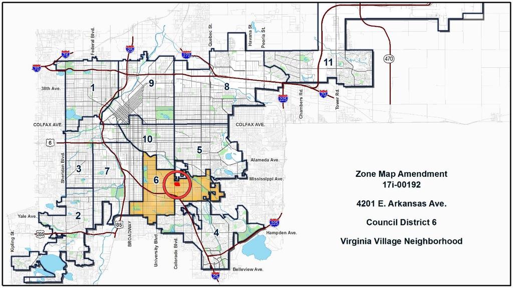
1 Community Planning and Development Planning Services 201 W. Colfax Ave., Dept. 205 Denver, CO p: f: TO: Denver Planning Board FROM: Andrew Webb, Senior City Planner DATE: RE: Official Zoning Map Amendment Application #2017I to change the zoning of a parcel at, 4040 E. Louisiana Ave. and 1380 S. Birch Street (Collectively referred to as ) from CMP-EI2 and S- MX-5 UO-1 UO-2 to S-MX-8 UO-2, S-MX-8, S-MX-5, S-MX-3, and S-MU-3 Staff Report and Recommendation Based on the criteria for review in the Denver Zoning Code, Staff recommends approval for Application #2017I in combination with a development agreement to address some key issues involved in redeveloping this large site. Request for Rezoning Address: 4040 E. Louisiana Ave., 4201 E. Arkansa Ave., and 1380 S. Birch Street (Collectively referred to as 4201 E. Arkansas Ave.) Neighborhood/Council District: Virginia Village, District 6 RNOs: Inter-Neighborhood Cooperation (INC), Virginia Village/Ellis Community Association Area of Property: Approximately Acres Current Zoning: CMP-EI2 and S-MX-5 UO-1 UO-2 Proposed Zoning: S-MX-8 UO-2, S-MX-8, S-MX-5, S-MX-3, and S-MU-3 Property Owner(s): State of Colorado Applicant: KRF Arkansas LLC Summary of Rezoning Request The subject property comprises two large parcels bounded by Louisiana Ave. to the north, Birch St. to the east, Arkansas Ave. to the south, and separated from Colorado Blvd. to the west by a row of commercial properties; and an approximately 15,000- square-foot parcel at the northeast corner of Birch St. and Arkansas Ave. The properties are owned by the Colorado Department of Transportation and have served as its
2 Page 2 headquarters since the early 1950s. CDOT recently relocated to new headquarters in Sun Valley near Colfax Ave. and Federal Blvd. and has vacated the site. Late last year, the City brokered an agreement with CDOT to acquire the site and then subsequently sell it to a private developer, Kentro Group, for redevelopment. As part of the deal, Kentro agreed to construct 150 units of affordable housing available to families making up to 60 percent of the area median income. According to its application, the company intends to build these units on the site as part of a mixed-use development that is also intended to include market-rate residential uses and commercial, retail and office space. The majority of the site is currently zoned CMP-EI2 (Campus Education/Institution - 2). The northwestern parcel is zoned S-MX-5 UO-1, UO-2 (Suburban Neighborhood Context, Mixed-Use, 5-story building heights, with the Adult and Billboard Use Overlay districts). This proposed rezoning would establish primarily S-MX- (Suburban, Mixed-Use) zone districts on the site, with heights ranging from 8 stories in the northwest corner and core of the site to 5 and 3 stories to the east and south, where the property is across the street from single- and multi-unit residential uses. It proposes to establish S-MU-3 (Suburban Neighborhood Context, Multi-Unit, 3-story maximum building height) at the northeast corner of Birch St. and Arkansas Ave. A map showing the proposed zone districts is shown below this summary. The rezoning is proposed to allow greater flexibility of uses, to establish improved street frontage design and to permit retail uses, which are not allowed in the CMP-EI2 district.

3 Page 3 Proposed Zoning for the subject site

4 Page 4
5 Page 5 Existing Context The site is primarily a campus of 1- to 4-story office structures built between the 1950s and 1970s. Buildings cover about a quarter of the core site, with the balance used for parking and landscaping. An approximately 150-foot telecommunications tower is situated outside the eastern edge of the area to be rezoned, midway between Louisiana and Arkansas Avenues. The undeveloped northwesternmost parcel was used to train highway maintenance employees and contractors on stormwater quality systems and erosion control, while the southeasternmost lot was used for vehicle storage and parking. The property is surrounded by 5- and 6-story multiunit residential development to the north and commercial development along Colorado Blvd. ranging from 2 to 9 stories to the west. To the south and east are multi- and single-unit residential uses along Birch St. and Arkansas Ave. that transition within a block to a primarily 1- and two-story single-unit residential neighborhood. The primary site is not currently penetrated by the area s streets, which reach dead ends north and south of the property. CDOT is currently in the process of demolishing buildings on the site. Aerial photo of site with proposed zone district boundaries
6 Page 6 The following table summarizes the existing context proximate to the subject site: Site North South East West Existing Zoning S-MX-5 UO-1, UO-2 (northwestern parcel); CMP-EI2 S-MX-5 UO-1, UO-2; S-MX-5; R-3 UO-3; S-MU- 5 S-MX-3; S-MU-3; S-SU-D S-MU-5; S-SU-D S-MX-5 UO-1; UO-2 Existing Land Use Vacant dirt lot (northwestern parcel); Office Retail, Office, Multi-Unit residential Retail, Office, Multi-Unit residential, Single- Unit residential, Multi-unit residential (to northeast); singleunit residential, surface parking Retail, Restaurants Existing Building Form/Scale 3 and 4-story office buildings 1 and 2-story commercial structures along Colorado Blvd., 3- to 6-story multi-unit residential. 1- to 6-story commercial and office structures along Colorado Blvd., 2-story multi-unit residential, transitioning to single-unit residential to the east 2-story multi-unit (across Birch at northeast); 1- and 2- story single-unit detached housing 1- and 2-story commercial structures oriented to Colorado Blvd. to the west. Existing Block, Lot, Street Pattern Orthogonal street grid in neighborhood, primary site is a single superblock with surface parking and drive aisles. Transit: Colorado Boulevard is served by RTD s Route 40, which provides service approximately every 15 minutes in this area. Birch St., which serves the eastern portion of the site, is an undesignated local street, but is served by a circulator bus, RTD Route 46, which carries
7 Page 7 passengers between the Denver Tech Center and Cherry Creek, with a stop at the Colorado RTD Light Rail station about a mile south of the subject site. Existing Zoning The core property s Campus Education/Institution zone district is a special district intended for educational institutions, public and institutional uses such as museums. it is established to allow for flexible placement of buildings and unified treatment of signs, open space, landscaping and other site elements while providing compatible transitions between the campus and adjacent neighborhoods per DZC Sec The S-MX-5 UO-1, UO-2 zoning established on the 50,000 square foot lot at the northwest corner of the site is intended to promote safe, active, pedestrian-scaled diverse areas and permits a mix of multi-unit residential, office, retail and similar uses. The UO-1 Use Overlay permits Adult Uses, which are governed by use limitations in DZC Article 11. The UO-2 Use Overlay permits Billboards, subject to standards in DZC Article 10. Zoning to the north of the subject site includes S-MX-5 UO-1, UO-2 for properties along Colorado, S-MX-5 (without the Adult Use and Billboard Overlays), and R-3 and S-MU-5 north of the subject site across Louisiana Ave. and to the east. The S-MX-5 zone district permits a mix of residential and commercial uses, while the R-3 (Former Chapter 59) and S-MU-5 zone districts promote multi-unit residential uses. Properties to the east across Birch St. are zoned S-MU-5 and S-SU-D. The S-MU-5 district permits 5-story multi-unit development, such as apartment buildings; while the S-SU-D zone district is a single-unit zone district with a minimum zone lot area of 6,000 square feet and a maximum height of 2.5 stories. Zoning to the south of the subject site across Arkansas is S-SU-D to the east, transitioning to S-MU-3 and S-MX-3 further west. These zone districts permit multi-unit residential and a mix of residential and commercial uses (respectively) in structures up to 3 stories in height. Parcels between the western boundary of the site and Colorado Blvd. are zoned S-MX-5 UO-1, UO-2, which is described above.

8 Page 8 Current zoning of site and nearby properties

9 Page 9 UO-2 The applicant proposes to retain the UO-2 use overlay at 4040 E. Louisiana Ave. where it currently applies. Many properties along Colorado Blvd. have this overlay. The Denver Zoning Code requires that any new standard-sized billboard be separated by at least 500 feet from any other outdoor advertising signs, along with other requirements, such as the removal of an existing billboard for every new one erected. Currently, two existing billboards are within 500 feet of the subject property, which would preclude the installation of new billboards unless both existing signs were removed. Staff is not aware of adopted policies for reducing the footprint of the UO-2 overlay in this area or anywhere else in the city and does not object to the applicant s proposal to retain it for this property. UO-2 area map Existing Land Uses Assessor data shows the existing use of the site s core parcel as office, while the northwestern most parcel is vacant and the southeastern parcel is used for parking. Surrounding land uses include a mix of commercial/retail and office to the west of the site. Multi-unit residential and single-unit residential uses characterize development north and south of the site, stepping down in intensity toward the southeast, which is primarily single-unit residential. A large auto

10 Page 10 body repair business directly north of the site is shown as industrial. A zoomed-out map (second graphic, below), shows a larger portion of Colorado Blvd. corridor between Glendale and Interstate 25 to better illustrate how more intensive commercial and residential uses that flank it transition to adjacent single-unit residential neighborhoods. Land uses on and proximate to site

11 Page 11 Land uses in area
12 Page 12 Other Considerations General Development Plan The site is not currently subject to a general development plan (GDP). Before or concurrent with an official map amendment application, the Department of Community Planning and Development (CPD) must determine whether a GDP is mandatory, according to DZC Section Preparation is mandatory when (1) the specific circumstances warrant a coordinated master framework plan to guide future development; and (2) land use, development, and infrastructure issues related to future development cannot be adequately resolved through other regulatory processes. In determining whether circumstances warrant a GDP, all relevant factors must be considered, including the following four factors set forth in the code. The factors are listed below with Staff s analysis of this site in italics. 1. Adopted Plan Recommendation A citywide land use, or small area plan, adopted by City Council as a supplement to the Comprehensive Plan, recommends preparation of a GDP for all or portions of the plan area. No citywide land use plan or small area plan recommends preparation of a GDP for all or a portion of the area to be rezoned. 2. Large-Scale Development The GDP area either: (a) is more than 10 acres, (b) is anticipated to be developed in phases; or (c) is owned by more than one person or entity. The area of the proposed rezoning is more than 10 acres and is anticipated to be developed in phases, but is currently owned by only one entity. 3. Infrastructure Network or System Improvements Future development in the GDP area anticipates any of the following infrastructure improvements: a. Establishing, extending, expanding, or otherwise changing the arterial or collector street grid; or b. Establishing, extending, expanding, or otherwise changing an existing regional storm water system; or c. Establishing, extending, expanding, or otherwise changing publicly accessible park and open space. No changes are planned to the arterial or collector street grid; a new local street will be added to break up the super-block and will be guaranteed with a development agreement. No changes are planned to regional storm water systems; local storm water improvements will be made in association with Site Development Plan review. Development in the area will establish publicly accessible open space, which will be guaranteed with a proposed development agreement. 4. Development Adjacent to Major River or Trail Corridors
13 Page 13 Development within 100 feet from the Cherry Creek corridor or the South Platte River corridor, where publicly-accessible open space, pedestrian connections, or bike connections to such corridors is anticipated. The site is not located within 100 feet of Cherry Creek or the South Platte River. Although this is a large site, factors that would be addressed through a GDP including roadway infrastructure and open space are being addressed in a development agreement. Details are described below. Considering all relevant factors, the specific circumstances here do not warrant an additional coordinated master framework plan and all remaining issues can be addressed with existing regulatory processes such as a development agreement and site development plan. Therefore, if a development agreement is executed to address these issues concurrent with approval of this rezoning, then CPD has determined that a GDP is not mandatory for this site. Proposed Development Agreement Kentro Corp. proposes a Development Agreement with the city to set forth commitments regarding traffic, drainage, affordable housing and other characteristics of the development. Such an agreement is important at this sensitive site, as it can provide some predictability about development characteristics that would otherwise not be addressed. General terms that have been agreed upon as of the writing of this report include: Commitment to construct 150 units of housing on site affordable to residents earning 60% of Area Median Income Provide open space on a minimum of 10% of the property (as would be required under a General Development Plan) Continue collaboration with CDOT to complete cleanup of solvent spill on northeast part of site. Salvage some on-site trees along Arkansas Ave. and work with Public Works to improve pedestrian infrastructure on that street frontage. Complete an ongoing traffic study and make on- and off-site infrastructure improvements to address traffic congestion and other issues as future development plans are better known. Utilize a transportation demand management plan and other techniques to reduce vehicle trips to and from the site. Reconnect part of the north-south street grid through the property along the Bellaire St. alignment


14 Page 14 Existing Building Form and Scale Existing building forms and scales found in the area are shown in the series of 45-degree aerials and street-view images of key sites on the following pages, sourced from Google Maps. Aerial view of subject site and surrounding development View of site from north, looking east along Louisiana Ave.


15 Page 15 View of site looking southwest from Louisiana Ave. and Birch St. View of front of site, looking north from Arkansas Ave. Grey tower in background is a 20-story Hyatt hotel in Glendale. View of site looking northwest from Arkansas Ave. and Birch St., showing small parking lot property east of primary site.


16 Page 16 Multi-unit residential development north of site, looking northwest along Louisiana Ave. Development to north of site, looking northeast along Louisiana Ave. Street frontage along Colorado Blvd., west of site (looking southeast along Colorado Blvd.)


17 Page 17 Single-unit residential development adjacent to southeast corner of site, at Arkansas Ave. and Birch St. Office complex on west side of Colorado Blvd., west of site Multi-unit development south of site

18 Page 18 Single-unit development directly east of site along Birch St. Summary of City Agency Referral Comments As part of the DZC review process, the rezoning application is referred to potentially affected city agencies and departments for comment. Comments received as of the writing of this report are as follows: A summary of agency referral responses follows: Public Works City Surveyor: Approved, No Comments (revisions made after earlier review) Development Services Wastewater: Approved, with comments: DS Wastewater approves the subject zoning change. The applicant should note that redevelopment of this site may require additional engineering including preparation of drainage reports, construction documents, and erosion control plans. Redevelopment may require construction of water quality and detention basins, public and private sanitary and storm sewer mains, and other storm or sanitary sewer improvements. Redevelopment may also require other items such as conveyance of util ity, construction, and maintenance easements. The extent of the required design, improvements and easements will be determined during the redevelopment process. Please note that no commitment for any new sewer service will be given prior to issuance of an approved SUDP [Sewer Use and Drainage Permit] from Development Services. Denver Department of Public Health and Environment: Approved, with comments: Denver Department of Public Health and Environment concurs with the rezoning but is aware of environmental concerns on the Property. The CDOT property at 4201 East Arkansas historically released solvents to groundwater, which resulted in groundwater contamination and the potential to affect indoor air quality. The affected area extends from the former onsite source near East Louisiana Avenue and South Birch Street northeast towards East Mississippi Avenue. The groundwater has been and continues to be remediated and as a result, the regulatory agency
19 Page 19 (Colorado Department of Public Health and Environment, CDPHE) issued a letter of No Further Action for the offsite indoor air pathway; and the former onsite source area meets commercial worker standards for indoor air. If the onsite use changes to residential for this area, then DDPHE requests that residential indoor air standards be met, or the indoor air be mitigated by systems such as ventilated subsurface parking garages or residential radon-type systems. Please note that this former source area affects a limited section of the CDOT property. Other areas of the property are being investigated as part of standard environmental due diligence, and if needed, these other areas will be addressed and remediated as coordinated with regulatory agencies to mitigate potential risk to residential use. General Notes: Most of Colorado is high risk for radon, a naturally occurring radioactive gas. Due to concern for potential radon gas intrusion into buildings, DEH suggests installation of a radon mitigation system in structures planned for human occupation or frequent use. It may be more cost effective to install a radon system during new construction rather than after construction is complete. If renovating or demolishing existing structures, there may be a concern of disturbing regulated materials that contain asbestos or lead-based paint. Materials containing asbestos or lead-based paint should be managed in accordance with applicable federal, state and local regulations. The Denver Air Pollution Control Ordinance (Chapter 4- Denver Revised Municipal Code) specifies that contractors shall take reasonable measures to prevent particulate matter from becoming airborne and to prevent the visible discharge of fugitive particulate emissions beyond the property on which the emissions originate. The measures taken must be effective in the control of fugitive particulate emissions at all times on the site, including periods of inactivity such as evenings, weekends, and holidays. Denver s Noise Ordinance (Chapter 36 Noise Control, Denver Revised Municipal Code) identifies allowable levels of noise. Properties undergoing Re-Zoning may change the acoustic environment, but must maintain compliance with the Noise Ordinance. Compliance with the Noise Ordinance is based on the status of the receptor property (for example, adjacent Residential receptors), and not the status of the noise-generating property. Violations of the Noise Ordinance commonly result from, but are not limited to, the operation or improper placement of HV/AC units, generators, and loading docks. Construction noise is exempted from the Noise Ordinance during the following hours, 7am 9pm (Mon Fri) and 8am 5pm (Sat & Sun). Variances for nighttime work are allowed, but the variance approval process requires 2 to 3 months. For variance requests or questions related to the Noise Ordinance, please contact Paul Riedesel, Denver Environmental Health ( ). Scope & Limitations: DEH performed a limited search for information known to DEH regarding environmental conditions at the subject site. This review was not intended to conform to ASTM standard practice for Phase I site assessments, nor was it designed to identify all potential
20 Page 20 environmental conditions. In addition, the review was not intended to assess environmental conditions for any potential right-of-way or easement conveyance process. The City and County of Denver provides no representations or warranties regarding the accuracy, reliability, or completeness of the information provided. Assessor; Real Estate; Denver Public Schools; Parks & Recreation; Development Services, Transportation; Development Services, Project Coordination; Development Services, Fire Prevention: No Response, Approval Assumed. Public Review Process Step CPD Informational Notice of Receipt of the rezoning application to all affected members of City Council and registered neighborhood organizations Community Meetings to present project and seek feedback CPD written notice of the April 5, 2017, Planning Board public hearing sent to all affected members of City Council and registered neighborhood organizations, mailed notice sent to property owners Date 6/1/18 1/25/18, 3/8/18, 4/5/18, 5/3/18, 6/7/18, 7/12/18 8/30/18 Scheduled Planning Board Public Hearing 9/19/18 Land Use, Transportation and Infrastructure Committee City Council First Reading City Council Public Hearing 10/9/18 (Tentative) 10/22/18 (Tentative) 11/19/18 (Tentative) Registered Neighborhood Organizations (RNOs) The RNOs identified on page 1 of this report were notified of this application. No comments have been received from RNOs as of the writing of this report. Community Meetings and Public Comment
21 Page 21 The City Council approved the 3-way transaction between the City, Kentro Group and CDOT in December The legislation called for a community process to ensure ensuing development is consistent with existing neighborhood, area plans, and economic and job development in Council District 6. Beginning in January 2018, Kentro Group held 6 public meetings in various locations near the site. Early meetings sought general input about desired business and housing types, amenities, and other redevelopment outcomes. At subsequent meetings, the applicant got more specific about the rezoning proposal and general layout they envisioned for the site. Staff attended all meetings to answer zoning questions and observe the process. Community input at the meetings ranged from excitement about the potential redevelopment of the site with new destinations for the neighborhood to deep concerns about increased traffic, development density and change in a neighborhood that has been somewhat insulated from the rapid evolution much of the city has experienced in recent years. Data collected from attendees during the early meetings indicated support for a Main Street development concept with businesses, cafes and restaurants lining a roadway connection through the site. In their application, Kentro Group cites the following as key aspirations they heard for the site from community members: a destination gathering places open to existing neighborhood residents quality design a quality public realm with vegetation a place to walk and bike to in the neighborhood In their presentations to community stakeholders, the company sought to show how their proposed rezoning would reduce building heights from what is currently permitted by the existing CMP-EI2 zoning. While CMP-EI2 does permit 150-foot building heights (approximately 12 stories), it requires that heights scale down adjacent to residential neighborhoods within a 45-degree bulk plane. In response to concerns that the proposed S-MX- zoning would permit too much building height across from lower-intensity residential uses along Arkansas Ave. and Birch St., the applicants proposed a system of striped zoning establishing a series of maximum building heights that step down to 3 stories (40 feet) along the site s southern and eastern edges. Revised heights: The company submitted its first formal application in late May, with proposed building heights ranging from 12 stories to the northwest to 3 at the southeast. Based on
22 Page 22 community feedback, the company submitted a revised application in June that reduced maximum building heights to 8 stories. Written Community Input Since the company s first application, staff has received 26 letters or s about this request. Of those, 13 indicated opposition to the project and 13 were in support. All correspondence is included with this staff report, in the order received. A summary of key points raised by opponents and supporters of the project in meetings and in writing follows, with some narrative and context provided. Concerns: As of the writing of this report, staff had received 13 letters or s stating opposition to this proposed rezoning. Stakeholders who expressed disapproval highlighted several issues. They include: Increased Traffic: The CDOT headquarters housed approximately 650 workers. A private engineering firm hired by the applicant performed traffic counts prior to CDOT s vacation of the site, recording approximately 1300 vehicle trips per day. Using building square footage assumptions derived from the proposed zoning to estimate impacts of future development, the same firm found that the redeveloped site would generate about 11,500 vehicle trips per day, a difference of more than 10,000 daily trips. The applicants have said that neighborhood impacts from this additional traffic will be mitigated by on- and off-site improvements to signalization and access points to the redevelopment that will prevent cut-through traffic on neighborhood streets. Additionally, they note that the proposed zone districts Suburban Neighborhood Context require the highest ratio of minimum parking in the Denver Zoning Code, and that adequate parking for all uses on the site will prevent visitors from parking in nearby neighborhoods. Finally, the applicants have said they will employ transportation demand management (TDM) techniques, such as incentivizing the use of high-frequency bus services on Colorado Blvd. and a circulator that passes the east side of the property along Birch on its route to RTD s Colorado light rail station. A TDM plan will be required by the proposed development agreement. Neighbors remain concerned that the area s narrow roadways and lack of direct access from the property to Colorado Blvd. will result in new traffic and increased congestion on nearby streets and intersections. Development density and height: Kentro Group proposes at least 150 units of affordable housing, as well as an unspecified number of market rate apartments and/or condominiums that could number in the hundreds. Some neighborhood residents indicated concern about high-density development in general, the addition of new households and the construction of tall buildings. An earlier proposed zoning strategy would have allowed up to 12 stories of mixed-use development on much of the site as is
23 Page 23 currently permitted by existing zoning, but this was revised to 8 stories in response to community input during the applicant s series of public meetings. It should be noted that the subject site is surrounded to the west and north by multi-story office and residential structures, including a 9-story office building across Colorado Blvd., 5- and 6- story apartment buildings to the north, and buildings up to 20 or more stories along the Colorado Blvd. corridor in both directions. Gentrification: The applicant proposes the new shops and restaurants in this redevelopment will help bring a sense of place to a currently vacant property. Some written comments highlight concerns that the redevelopment will attract wealthier residents and result in increased rents and property values in what they say has historically been an affordable neighborhood. Applicant representatives have said that the 150 affordable units, along with Affordable Housing Linkage Fees required of market-rate residential and non-residential development on the site will help mitigate these concerns. Lack of Specificity: It is common for a developer to seek zoning approval prior to completing further site planning and determination of a tenant mix. This proposed rezoning, if adopted, would change the mix of uses permitted on the site and establish standards for site design, building placement and street frontages. However, multiple development outcomes could meet zoning criteria, making it hard to predict what development will look like until later phases when site development plan approval is sought. This has caused concern among community members who fear the zoning approval will result in new development that is redundant to retail uses already along Colorado Blvd., or otherwise undesirable. Environmental Concerns: A former CDOT Materials Testing Laboratory leaked solvents into soil at the northeast corner of the site until the spill s discovery in the 1980s. Some neighborhood stakeholders expressed concern that sale and redevelopment of the site will result in cleanup efforts being abandoned. The applicant representatives have said they eventually plans a mix of uses at this location on the site, including residential, which will require soil cleanup. Responsibility for cleanup is intended to remain CDOT s, and this is reflected in real estate documents and a proposed Development Agreement between the City and Kentro Group that is under consideration parallel to this rezoning application. (See Proposed Development Agreement above, and Agency Review comments from Denver Department of Public Health and Environment, above) Other issues highlighted in comments received included concerns that new development will be out of character with the 1940s and 50s-era architecture of Virginia Village, and that the development won t include enough outdoor space in an area that already has few parks. The latter is proposed to be addressed in a proposed
24 Page 24 Development Agreement under consideration parallel to this rezoning application. (See Proposed Development Agreement above) Support: As of the writing of this report, staff had received 13 letters of support for the rezoning and redevelopment of the site, highlighting potential benefits such as: Vibrancy: Commercial activity along Colorado Boulevard is highly auto-oriented, with structures set back behind large parking lots and oriented away from nearby neighborhoods. Some stakeholders have said that the redevelopment of the CDOT site presents opportunities for a vibrant, walkable neighborhood-scale commercial district that would serve the nearby neighborhoods. Affordable Housing: Many stakeholders who expressed support for the project highlighted its potential to provide at least 150 units of housing affordable for people earning 60% of Area Median Income (Household AMI for a family of 3 is currently $81,000 according to City and County of Denver data; 60% of that would be $48,600). Some supporters noted that higher residential densities assist in the production of affordable housing by offsetting the cost of below-market units. Additionally, some stakeholders said they hoped the affordable housing would help keep families in the area as housing prices rise and larger families seek opportunities outside Virginia Village. Two community members, including the principal of nearby Ellis Elementary School, specifically highlighted the need for affordable housing to stabilize enrollment at nearby schools. Sustainability: Several stakeholders suggested that redevelopment of the property is an opportunity to direct development and households to an area where it is best served by existing community and infrastructure as an alternative to continued urban sprawl at the city s edges, making it an environmentally-sustainable reuse of an underutilized property. At meetings and in writing, some neighbors expressed hope that the development will contribute to increased transit demand in the area, possibly leading to service improvements, such as Bus Rapid Transit on Colorado Blvd. (a street which is slated for this or similar high-quality transit service in adopted plans). Criteria for Review / Staff Evaluation The criteria for review of this rezoning application are found in DZC, Sections and , as follows: DZC Section Consistency with Adopted Plans
25 Page Uniformity of District Regulations and Restrictions 3. Public Health, Safety and General Welfare DZC Section Justifying Circumstances 2. Consistency with Neighborhood Context Description, Zone District Purpose and Intent Statements 1. Consistency with Adopted Plans The following plans apply to this property: Denver Comprehensive Plan 2000 Blueprint Denver (2002) Note: the application also cites the 1973 Virginia Village Neighborhood Plan and the Blueprint Denver: A Blueprint for an Inclusive City Public Review Draft 8/6/18 currently under public review. The 1973 Virginia Village Neighborhood Plan was not re-adopted by Denver Comprehensive Plan 2000 and is no longer applicable. Blueprint Denver: A Blueprint for an Inclusive City Public Review Draft 8/6/18 is not an adopted plan. Therefore, they do not apply to review of this application. Denver Comprehensive Plan 2000 The proposal is consistent with many Denver Comprehensive Plan objectives, strategies and recommendations, including: Environmental Sustainability Strategy 1-A: Encourage redevelopment of vacant, underutilized and environmentally compromised land known as brownfields. (p. 37) Environmental Sustainability Strategy 2-F: Conserve land by: promoting infill development within Denver at sites where services and infrastructure are already in place; designing mixed use communities and reducing sprawl so that residents can live, work and play within their own neighborhoods, and creating more density at transit nodes. (p. 39) Environmental Sustainability Strategy 4-A: Promote the development of sustainable communities and centers of activity where shopping, jobs, recreation and schools are accessible by multiple forms of transportation, providing opportunities for people to live where they work. (p. 41) Land Use Strategy 3-B: Encourage quality infill development that is consistent with the character of the surrounding neighborhood; that offers opportunities for increased density and more amenities; and that broadens the variety of compatible uses. (p. 60) Land Use Strategy 3-D: Identify and enhance existing focal points in neighborhoods, and encourage the development of such focal points where none exist. (p. 60)
26 Page 26 Denver s Legacies Strategy 3-A: Identify areas in which increased density and new uses are desirable and can be accommodated. (p. 99) Housing Strategy 6-A: Support Mixed-Use Development consistent with the goal of the Comprehensive Plan s land-use and mobility strategies. (p. 117) Housing Strategy 6-B: Continue to support mixed-income housing development that includes affordable rental and for-purchase housing for lower-income, entry-level and service employees, especially in Downtown and along transit lines. (p. 117) Economic Activity Strategy 1-H: Support a variety of housing opportunities for Denver s current and future workforce. Housing opportunities throughout Denver should be expanded especially in the Downtown core and near employment centers to accommodate people and families of all incomes. (p. 131) This proposed rezoning will promote infill development and broaden the variety of uses allowed to encourage redevelopment of a large, underutilized site with commercial, office and residential uses aimed at a range of incomes. It is consistent with Comprehensive Plan 2000 Environmental Sustainability objectives and strategies because it will conserve land by encouraging infill that allows people to live near jobs and daily needs. The proposal is consistent with Comprehensive Plan 2000 Land Use objectives and strategies because the mixed-use and multi-unit zoning will improve the variety of compatible land uses and promote infill development served by existing infrastructure and services. It will enable the development of a community-desired walkable destinations like shops and food and beverage businesses in an area where commercial uses are currently highly auto-oriented and serve a more regional customer base. Finally, the proposed zoning is consistent with Comprehensive Plan Housing and Economic Activity objectives and strategies because it will encourage redevelopment of the site that will include, pursuant to the companion Development Agreement, at least 150 units of housing for residents earning 60% of Area Median Income or less, located along high-frequency bus transit in a central city location near employment centers. Blueprint Denver: Concept Land Use Core and southeast parcels: As shown in the map below, the largest parcel, as well as the lot to the far southeast are designated with a Concept Land Use of Single Family Residential. This land use represents the majority of Denver s residential areas with densities at fewer than 10 units per acre and an employment base that is significantly smaller than the housing base. (p. 42). These same properties, which represent about ¾ of the total land affected by this proposal, are within an area designated as an Area of Stability. Areas of Stability comprise the vast majority of Denver, primarily the stable residential neighborhoods and their associated commercial areas, where limited change is expected in the next 20 years. (p. 120) The overarching goal for Areas of Stability is to identify and maintain the character of an area while accommodating some new development and redevelopment. (p. 140).
27 Page 27 In the narrative provided with this proposal, the applicants cite language in Blueprint Denver describing two types of Areas of Stability, Committed Areas and Reinvestment Areas. Committed areas are neighborhoods that may benefit from small infill redevelopment, rather than large-scale, major redevelopment; while Reinvestment Areas are those neighborhoods with a character that is desirable to maintain but that would benefit from reinvestment through modest infill and redevelopment or major projects in a small area. These areas would encourage investment but in a more limited and targeted way than in Areas of Change. (p. 122) Blueprint doesn t specifically identify Committed or Reinvestment areas. Generally speaking, however, the property, put in flux by the recent vacation of outdated office buildings, has characteristics of an area of the city that could benefit from reinvestment. Especially as it relates to properties to the north and west, redevelopment of this property has the potential to introduce higher-density development that is more walkable and creates a sense of place that some nearby multi-unit and commercial development lacks. Due to this site s size, location near a major roadway and high-density development and existing zoning that allows multi-unit residential uses, it is unlikely that it would redevelop with single-unit uses. Given these constraints, the S-MX- zone districts with a range of permitted building heights that transition down toward the single-unit neighborhoods to the southeast are appropriate and consistent with Blueprint Denver s acknowledgement that some associated commercial areas designated as Single Family Residential will undergo reinvestment that can benefit nearby neighborhoods. The S-MX- zone districts permit new retail uses and establish design standards that will help create a walkable, mixed-use node. While the existing zoning does permit the residential and office uses proposed, it was developed for campuses with interior flexibility and exterior transitions, and does not set adequate standards for development that addresses streets and transitions into surrounding urban fabric. Northwestern parcel: The property on the northwestern corner of the subject site is designated with a Concept Future land use of Commercial Corridor and as an Area of Change. Commercial Corridors are described by Blueprint as linear business districts primarily oriented to heavily used arterial streets. (p. 45) The proposed zoning of S-MX-8 at the site is consistent with Blueprint Denver recommendations, especially in light of surrounding zoning. It allows more business uses than the current zoning. The S-MX-8 zone district is intended to be located in areas served primarily by arterial streets. This site is not directly served by arterial streets, but access to nearby Colorado Blvd., one of the arterials cited by name in Blueprint Denver, is provided via Louisiana Ave. Areas of Change are where Blueprint Denver recommends the city channel the majority of growth and development. They include areas along corridors with frequent bus service that can accommodate development, especially where there is potential for a pedestrian-friendly shopping environment (p. 19). It is appropriate to direct growth to this location, where higher-intensity uses closely integrated with transportation can accommodate new residents and jobs while preserving nearby established neighborhoods.
28 Page 28 Blueprint Denver: Future Street Classifications The site is located east of Colorado Blvd., and access is provided to and from the north and south edges of the site by Louisiana Ave. and Arkansas Ave., respectively. Blueprint Denver designates Colorado Blvd. with a future street type of Commercial Arterial and identifies it as an Enhanced Transit Corridor. According to the Denver Zoning Code, the S-MX-5 and -8 zone districts are intended to be located where served primarily by collector or arterial streets. Both streets provide access to Colorado at signalized intersections. Blueprint identifies them as undesignated local streets. Arkansas and Louisiana Avenues are comparable to other local streets immediately adjacent to Colorado Blvd. in this area in that they provide side-street access to commercial, office and higher-density residential uses along the corridor. The proximity and access to Colorado Blvd. is appropriate for the S-MX- and S-MU- zone districts proposed. Birch St., which abuts the eastern edge of the property, is also designated as a local street. The S-MX-3 and S-MU-3 zone districts proposed along this corridor are described by the Zoning Code as intended for areas or intersections served by local or collector streets, and are appropriate for access from Birch St. Providing access to the site while minimizing traffic impacts on nearby low-density residential neighborhoods will take careful planning that routes trips toward streets intended for regional use, rather than through the neighborhood. Staff recommends this request be considered in conjunction with a Development Agreement that establishes a commitment to traffic management options, including application of transportation demand management techniques to encourage reduced vehicle trips and increased transit use. (See Proposed Development Agreement, above).

29 Page 29 Blueprint Denver map Building Heights: in the absence of adopted policy for building heights in this area, the applicant s propose to reduce currently permitted heights (150 feet) while allowing taller development closer to existing development of similar scale in the northern and western parts of the subject site. More modest building heights of 3 stories (40 feet) along the Arkansas Ave. and Birch St. frontages are appropriate across the street from single-unit development where zoning permits 2.5 stories, or up to 35 feet in building height. 2. Uniformity of District Regulations and Restrictions Establishment of the S-MX- and S-MU- districts will result in the uniform application of zone district building form, use and design regulations within each zone district as uniformly applied in the same zone districts throughout the city. 3. Public Health, Safety and General Welfare This proposed official map amendment furthers the public health, safety and general welfare of the City, primarily through implementation of the city s adopted land use plans, including Comprehensive Plan 2000 and Blueprint Denver. Encouraging the redevelopment of this underutilized brownfield site will enable job opportunities and affordable housing at a location
30 Page 30 that is well served by high-frequency transit. Mixed-use development here can also demonstrate alternatives to existing auto-oriented development in this example of the Suburban Neighborhood Context, providing a walkable destination for community members to shop and socialize. The general welfare is also promoted by improved building form standards that create a more pedestrian-friendly urban environment and an expanded list of allowed uses that will enable a more mixed-use community. Additionally, this rezoning proposal clearly identifies a transitioning building scale that that respects the single-unit, low-scale character of neighborhoods further south and east. 4. Justifying Circumstances The Denver Zoning Code identifies the following relevant justifying circumstance in Section A.4., which reads: Since the date of the approval of the existing Zone District, there has been a change to such a degree that the proposed rezoning is in the public interest. Such change may include: a. Changed or changing conditions in a particular area, or in the city generally; or, b. A City adopted plan; or c. That the City adopted the Denver Zoning Code and the property retained Former Chapter 59 zoning. The applicant cites rapid population growth as the relevant changed condition, causing an increased demand for housing. The applicant s proposed justification is consistent with the Denver Zoning Code criteria. Current and projected population growth estimates Denver s population will increase by more than 20 percent by Additionally, the closure and vacation of the CDOT headquarters at the site constitutes a changed condition for the property to such a degree that the proposed rezoning is in the public interest. The site is no longer an institution campus because the institution has relocated and therefore the institutional campus zoning should change. 5. Consistency with Neighborhood Context Description, Zone District Purpose and Intent Statements. The proposed zone districts are in the Suburban Neighborhood Context. According to DZC Division 3.1, the Suburban Neighborhood Context is characterized by single-unit and mult-unit residential, commercial strips and centers, and office parks. This Context includes occasional mid- and high-rise Apartment building forms, surface parking and generous landscaping between the street and buildings in deep setbacks. The site to be rezoned is consistent with this neighborhood context description.
31 Page 31 Mixed-Use districts in the Suburban Neighborhood Context are intended to promote active, pedestrian-scaled places that enhance the convenience and ease of walking, shopping and public gathering within and around the city s neighborhoods, and are appropriate along corridors, for larger sites and at major intersections. They aim to ensure new development contributes positively to established residential neighborhoods and character, and improves the transition between commercial development and adjacent residential neighborhoods. ( A. through D.). The zone district specific intent of S-MX-8 is, S-MX-8 applies to areas or intersections served primarily by arterial streets where a building scale of 1 to 8 stories is desired ( H). The specific intent of S-MX-5 is, S-MX-5 applies to areas or intersections served primarily by collector or arterial streets where a building scale of 1 to 5 stories is desired ( F). The specific intent of S-MX-3 is, S-MX-3 applies to areas or intersections served primarily by local or collector streets where a building scale of 1 to 3 stories is desired ( D). The Suburban Multi-Unit districts are intended to accommodate reinvestment without detracting from the overall image and character of the residential neighborhood. ( A. and D.). The specific intent of all S-MU- zone districts is that, S-MU- is a multi unit district and allows suburban house, duplex, row house, and apartment building forms up to 3, 5, 8, 12, 20 stories in height ( I). The proposed rezoning is consistent with these purpose and intent statements, as it would permit redevelopment of an underutilized, currently vacant site with uses that serve neighborhood residents and provide additional housing units to support nearby businesses and transit, while providing appropriate transitions into the single-unit neighborhoods to the southeast of the subject site. Attachments 1. Application public comments received prior to the writing of this report, in a single document in order received
Land Use, Transportation, and Infrastructure Committee of the Denver City Council FROM: Scott Robinson, Senior City Planner DATE: March 22, 2018 RE:
 Community Planning and Development Planning Services 201 W. Colfax Ave., Dept. 205 Denver, CO 80202 p: 720.865.2915 f: 720.865.3052 www.denvergov.org/cpd TO: Land Use, Transportation, and Infrastructure
Land Use, Transportation, and Infrastructure Committee of Denver City Council FROM: Scott Robinson, Senior City Planner DATE: December 6, 2018 RE:
 Community Planning and Development Planning Services 201 W. Colfax Ave., Dept. 205 Denver, CO 80202 p: 720.865.2915 f: 720.865.3052 www.denvergov.org/cpd TO: Land Use, Transportation, and Infrastructure
Land Use, Transportation, & Infrastructure Committee of the Denver City Council FROM: Chandler Van Schaack, Senior City Planner DATE: July 3, 2018 RE:
 Community Planning and Development Planning Services TO: Land Use, Transportation, & Infrastructure Committee of the Denver City Council FROM: Chandler Van Schaack, Senior City Planner DATE: July 3, 2018
Denver City Council Land Use, Transportation, and Infrastructure Committee FROM: Courtney Levingston, Senior City Planner DATE: July 26, 2018 RE:
 TO: Denver City Council Land Use, Transportation, and Infrastructure Committee FROM: Courtney Levingston, Senior City Planner DATE: RE: Official Zoning Map Amendment Application #2017I-00151 Staff Report
Official Zoning Map Amendment Application #2017I Gaylord Street and York Street Rezoning from U-RH-2.5 to U-RX-3 and U-RX-5
 Community Planning and Development Planning Services 201 W. Colfax Ave., Dept. 205 Denver, CO 80202 p: 720.865.2915 f: 720.865.3052 www.denvergov.org/cpd TO: Denver Planning Board FROM: Elizabeth Weigle,
Staff Report and Recommendation Based on the criteria for review in the Denver Zoning Code, Staff recommends approval for Application #2017I
 TO: Denver Planning Board, Joel Noble, Chair FROM: Theresa Lucero, Senior City Planner DATE: RE: Official Zoning Map Amendment Application #2017I-00163 Staff Report and Recommendation Based on the criteria
Official Zoning Map Amendment Application #2018I-00120
 Community Planning and Development Planning Services 201 W. Colfax Ave., Dept. 205 Denver, CO 80202 p: 720.865.2915 f: 720.865.3052 www.denvergov.org/cpd TO: Denver Planning Board FROM: Scott Robinson,
Official Zoning Map Amendment Application #2017I and 4889 South Quebec Street Rezoning from B-4 with waivers, UO-1, UO-2 to C-MX-20
 Community Planning and Development Planning Services 201 W. Colfax Ave., Dept. 205 Denver, CO 80202 p: 720.865.2915 f: 720.865.3052 www.denvergov.org/cpd TO: Denver Planning Board FROM: Jeff Hirt, Senior
Official Zoning Map Amendment Application #2017I-00094
 Community Planning and Development Planning Services 201 W. Colfax Ave., Dept. 205 Denver, CO 80202 p: 720.865.2915 f: 720.865.3052 www.denvergov.org/cpd TO: Denver Planning Board FROM: Scott Robinson,
Official Zoning Map Amendment Application #2018I-00067
 Community Planning and Development Planning Services 201 W. Colfax Ave., Dept. 205 Denver, CO 80202 p: 720.865.2915 f: 720.865.3052 www.denvergov.org/cpd TO: Denver Planning Board FROM: Courtney Levingston,
Staff Report and Recommendation Based on the criteria for review in the Denver Zoning Code, Staff recommends approval for application #2017I
 TO: Denver City Council, Land Use, Transportation and Infrastructure Committee FROM: Theresa Lucero, Senior City Planner DATE: RE: Official Zoning Map Amendment Application #2017I-00153 Staff Report and
Block bounded by Newton St., 17 th Ave., Lowell Blvd., and 16 th Ave.; plus Meade Street (evens only)
") Community Planning and Development Planning Services 201 W. Colfax Ave., Dept. 205 Denver, CO 80202 p: 720.865.2915 f: 720.865.3052 www.denvergov.org/cpd TO: Denver Planning Board FROM: Sara White, AICP,
Community Planning and Development Planning Services 201 W. Colfax Ave., Dept. 205 Denver, CO 80202 p: 720.865.2915 f: 720.865.3052 www.denvergov.org/cpd TO: Denver Planning Board FROM: Sara White, AICP,
Brad Buchanan, Executive Director, Department of Community Planning and Development
 TO: City Council FROM: Jeff Hirt, Senior City Planner DATE: RE: Official Zoning Map Amendment Application #2017I-00076 3400 Arkins Ct., 3460 Arkins Ct., 1900 35 th St, 1930 35th St., 1950 35 th St Rezoning
REZONING GUIDE. Zone Map Amendment (Rezoning) - Application. Rezoning Application Page 1 of 3. Return completed form to
 - Application. Rezoning Application Page 1 of 3. Return completed form to") Zone Map Amendment (Rezoning) - Application COMMUNITY PLANNING & DEVELOPMENT REZONING GUIDE Rezoning Application Page 1 of 3 PROPERTY OWNER INFORMATION* CHECK IF POINT OF CONTACT FOR APPLICATION Property
Zone Map Amendment (Rezoning) - Application COMMUNITY PLANNING & DEVELOPMENT REZONING GUIDE Rezoning Application Page 1 of 3 PROPERTY OWNER INFORMATION* CHECK IF POINT OF CONTACT FOR APPLICATION Property
REZONING GUIDE. Zone Map Amendment (Rezoning) - Application. Rezoning Application Page 1 of 3. Return completed form to
 - Application. Rezoning Application Page 1 of 3. Return completed form to") COMMUNITY PLANNING & DEVELOPMENT REZONING GUIDE Rezoning Application Page 1 of 3 Zone Map Amendment (Rezoning) - Application PROPERTY OWNER INFORMATION* PROPERTY OWNER(S) REPRESENTATIVE** CHECK IF POINT
COMMUNITY PLANNING & DEVELOPMENT REZONING GUIDE Rezoning Application Page 1 of 3 Zone Map Amendment (Rezoning) - Application PROPERTY OWNER INFORMATION* PROPERTY OWNER(S) REPRESENTATIVE** CHECK IF POINT
Request for Rezoning. Current Zoning: Proposed Zoning:
 TO: Denver City Council, Neighborhoods and Planning Committee FROM: Theresa Lucero, Senior City Planner DATE: March 31, 2016 RE: Zoning Map Amendment #2015I-00150 Rezoning from M-RX-5 to I-MX-3 Community
REZONING GUIDE. Zone Map Amendment (Rezoning) - Application. Rezoning Application Page 1 of 3. Return completed form to
 - Application. Rezoning Application Page 1 of 3. Return completed form to") COMMUNITY PLANNING & DEVELOPMENT REZONING GUIDE Rezoning Application Page 1 of 3 Zone Map Amendment (Rezoning) - Application PROPERTY OWNER INFORMATION* PROPERTY OWNER(S) REPRESENTATIVE** CHECK IF POINT
COMMUNITY PLANNING & DEVELOPMENT REZONING GUIDE Rezoning Application Page 1 of 3 Zone Map Amendment (Rezoning) - Application PROPERTY OWNER INFORMATION* PROPERTY OWNER(S) REPRESENTATIVE** CHECK IF POINT
Official Zoning Map Amendment Application #2017I-00090
 Community Planning and Development Planning Services 201 W. Colfax Ave., Dept. 205 Denver, CO 80202 p: 720.865.2915 f: 720.865.3052 www.denvergov.org/cpd TO: Land Use, Transportation, & Infrastructure
Official Zoning Map Amendment Application #2018I-00095
 Community Planning and Development Planning Services 201 W. Colfax Ave., Dept. 205 Denver, CO 80202 p: 720.865.2915 f: 720.865.3052 www.denvergov.org/cpd TO: Denver Planning Board FROM: Ella Stueve, Senior
Article 3. SUBURBAN (S-) NEIGHBORHOOD CONTEXT
 NEIGHBORHOOD CONTEXT") Article 3. SUBURBAN (S-) NEIGHBORHOOD CONTEXT this page left intentionally blank Contents ARTICLE 3. SUBURBAN (S-) NEIGHBORHOOD CONTEXT DIVISION 3.1 NEIGHBORHOOD CONTEXT DESCRIPTION...3.1-1 Section 3.1.1
Article 3. SUBURBAN (S-) NEIGHBORHOOD CONTEXT this page left intentionally blank Contents ARTICLE 3. SUBURBAN (S-) NEIGHBORHOOD CONTEXT DIVISION 3.1 NEIGHBORHOOD CONTEXT DESCRIPTION...3.1-1 Section 3.1.1
To: S-MX-8 AIO, S-MX-8A AIO, S-MX-12 AIO, C-MX-8 AIO, C-MX-12 AIO, and S-CC-5 AIO
 Community Planning and Development Planning Services 201 W. Colfax Ave., Dept. 205 Denver, CO 80202 p: 720.865.2915 f: 720.865.3052 www.denvergov.org/cpd TO: Denver City Council FROM: Curt Upton, Senior
Representative Name. Address. City, State, Zip. Telephone.
 COMMUNITY PLANNING & DEVELOPMENT ~~DENVER... THE MILE HIGH CITY REZONING GUIDE Zone Map Amendment (Rezoning)- Application Rezoning Application Page 1 of 3 Property Owner Name Philip M. Falco Address 730
REZONING GUIDE. Zone Map Amendment (Rezoning) - Application. Rezoning Application Page 1 of 3. Return completed form to
 - Application. Rezoning Application Page 1 of 3. Return completed form to") Zone Map Amendment (Rezoning) - Application COMMUNITY PLANNING & DEVELOPMENT REZONING GUIDE Rezoning Application Page 1 of 3 PROPERTY OWNER INFORMATION* CHECK IF POINT OF CONTACT FOR APPLICATION Property
Zone Map Amendment (Rezoning) - Application COMMUNITY PLANNING & DEVELOPMENT REZONING GUIDE Rezoning Application Page 1 of 3 PROPERTY OWNER INFORMATION* CHECK IF POINT OF CONTACT FOR APPLICATION Property
Public Review of the Slot Home Text Amendment
 Public Review of the Slot Home Text Amendment The proposed amendments to the Denver Zoning Code have been informed by the Slot Home Strategy Report. This document has been developed out of a robust process
PLANNING COMMISSION STAFF REPORT
 PLANNING COMMISSION STAFF REPORT REZONING CASE: RZ-16-001 REPORT DATE: March 8, 2016 CASE NAME: Trailbreak Partners Rezoning PLANNING COMMISSION DATE: March 16, 2016 ADDRESSES OF REZONING PROPOSAL: 5501
Telephone AC / 21,960 SF G-MU-3 G-MX-3
 Zone Map Amendment (Rezoning) - Application PROPERTY OWNER INFORMATION* CHECK IF POINT OF CONTACT FOR APPLICATION Property Owner Name Siddhartha Rathod Address City, State, Zip Telephone Email COMMUNITY
Bylaw No , being "Official Community Plan Bylaw, 2016" Schedule "A" DRAFT
 Bylaw No. 2600-2016, being "Official Community Plan Bylaw, 2016" Schedule "A" Urban Structure + Growth Plan Urban Structure Land use and growth management are among the most powerful policy tools at the
REZONING GUIDE. Zone Map Amendment (Rezoning) - Application. Rezoning Application Page 1 of 3. Return completed form to
 - Application. Rezoning Application Page 1 of 3. Return completed form to") Zone Map Amendment (Rezoning) - Application COMMUNITY PLANNING & DEVELOPMENT REZONING GUIDE Rezoning Application Page 1 of 3 PROPERTY OWNER INFORMATION* CHECK IF POINT OF CONTACT FOR APPLICATION Property
Zone Map Amendment (Rezoning) - Application COMMUNITY PLANNING & DEVELOPMENT REZONING GUIDE Rezoning Application Page 1 of 3 PROPERTY OWNER INFORMATION* CHECK IF POINT OF CONTACT FOR APPLICATION Property
DIVISION 1.3 OFFICIAL ZONING MAP
 Article 1. General Provisions Division 1.3 Official Zone Map DIVISION 1.3 OFFICIAL ZONING MAP SECTION 1.3.1 ADOPTION OF OFFICIAL MAP The digital maps created and maintained by the Department of Community
REZONING GUIDE. Zone Map Amendment (Rezoning) - Application. Rezoning Application Page 1 of 3. Return completed form to
 - Application. Rezoning Application Page 1 of 3. Return completed form to") Zone Map Amendment (Rezoning) - Application COMMUNITY PLANNING & DEVELOPMENT REZONING GUIDE Rezoning Application Page 1 of 3 PROPERTY OWNER INFORMATION* CHECK IF POINT OF CONTACT FOR APPLICATION Property
Zone Map Amendment (Rezoning) - Application COMMUNITY PLANNING & DEVELOPMENT REZONING GUIDE Rezoning Application Page 1 of 3 PROPERTY OWNER INFORMATION* CHECK IF POINT OF CONTACT FOR APPLICATION Property
PLANNED UNIT DEVELOPMENT & SUBDIVISION STAFF REPORT Date: April 18, 2019
 PLANNED UNIT DEVELOPMENT & SUBDIVISION STAFF REPORT Date: April 18, 2019 DEVELOPMENT NAME SUBDIVISION NAME Springhill Village Subdivision Springhill Village Subdivision LOCATION 4350, 4354, 4356, 4358,
this page left intentionally blank DENVER ZONING CODE
 Article 1. GENERAL PROVISIONS this page left intentionally blank Contents ARTICLE 1. GENERAL PROVISIONS DIVISION 1.1 GENERAL...1.1-1 Section 1.1.1 Purpose...1.1-1 Section 1.1.2 Intent...1.1-1 Section 1.1.3
Based on the criteria for review in the Denver Zoning Code, Staff recommends approval for Application #2018I
 Community Planning and Development Planning Services 201 W. Colfax Ave., Dept. 205 Denver, CO 80202 p: 720.865.2915 f: 720.865.3052 www.denvergov.org/cpd TO: Denver Planning Board FROM: Chandler Van Schaack,
WESTMINSTER PARK SUBDIVISION
 WESTMINSTER PARK SUBDIVISION Engineering Comments: FINAL PLAT COMMENTS (should be addressed prior to submitting the FINAL PLAT for review and/or signature by the City Engineer): A. Provide all of the required
Official Zoning Map Amendment Application #2015I Marion St. Rezoning from U-SU-A1 to U-MX-2x
 Community Planning and Development Planning Services 201 W. Colfax Ave., Dept. 205 Denver, CO 80202 p: 720.865.2915 f: 720.865.3052 www.denvergov.org/cpd TO: Denver City Council FROM: Courtland Hyser,
PLAINFIELD CHARTER TOWNSHIP COMMUNITY DEVELOPMENT DEPARTMENT PLANNING, ZONING & BUILDING SERVICES MEMORANDUM
 PLAINFIELD CHARTER TOWNSHIP COMMUNITY DEVELOPMENT DEPARTMENT PLANNING, ZONING & BUILDING SERVICES 6161 BELMONT AVENUE N.E. BELMONT, MI 49306 PHONE 616-364-1190 FAX: 616-364-1170 www.plainfieldchartertwp.org
DZC and DRMC Amendments to Implement 38th and Blake Station Area Height Amendments
 DZC and DRMC Amendments to Implement 38th and Blake Station Area Height Amendments DZC Text Amendment #2 to establish River North Design Overlay (DO-7) / 38 th and Blake Incentive Overlay (IO-1) (CB18-0016)
RC ; Reclassification The Garrison at Stafford Proffer Amendment (formerly Stafford Village Center)
") Board of Supervisors Robert Bob Thomas, Jr., Chairman Laura A. Sellers, Vice Chairman Meg Bohmke Jack R. Cavalier Wendy E. Maurer Paul V. Milde, III Gary F. Snellings Anthony J. Romanello, ICMA CM County
Board of Supervisors Robert Bob Thomas, Jr., Chairman Laura A. Sellers, Vice Chairman Meg Bohmke Jack R. Cavalier Wendy E. Maurer Paul V. Milde, III Gary F. Snellings Anthony J. Romanello, ICMA CM County
EXHIBIT 1 PROJECT DESCRIPTION AND DESCRIPTION OF REQUESTED AREA VARIANCES REDEVELOPMENT OF 201 ELLICOTT STREET
 EXHIBIT 1 PROJECT DESCRIPTION AND DESCRIPTION OF REQUESTED AREA VARIANCES REDEVELOPMENT OF 201 ELLICOTT STREET I. PROJECT DESCRIPTION: Ciminelli Real Estate Corporation (the Applicant ) is seeking area
REPORT TO THE SHELBY COUNTY PLANNING COMMISSION From the Department of Development Services Planning Services. February 4, 2019
 REPORT TO THE SHELBY COUNTY PLANNING COMMISSION From the Department of Development Services Planning Services February 4, 2019 Case No. Request for Rezoning Approval From E-1 to E-2 SD This is a request
ZONING AMENDMENT & SUBDIVISION STAFF REPORT Date: November 3, 2016
 ZONING AMENDMENT & SUBDIVISION STAFF REPORT Date: November 3, 2016 APPLICANT NAME SUBDIVISION NAME David Shumer 5955 Airport Subdivision CITY COUNCIL DISTRICT District 6 5955 Airport Boulevard, 754 Linlen
Cover Letter with Narrative Statement
 Cover Letter with Narrative Statement March 31, 2017 rev July 27, 2017 RE: Rushton Pointe Residential Planned Unit Development Application for Public Hearing for RPUD Rezone PL2015 000 0306 Mr. Eric Johnson,
PLANNING COMMISSION STAFF REPORT
 PLANNING COMMISSION STAFF REPORT REZONING CASE: RZ-15-002 REPORT DATE: January 26, 2016 CASE NAME: Thursday Lunch Club Rezoning PLANNING COMMISSION DATE: February 17, 2016 ADDRESS OF REZONING PROPOSAL:
PLANNING COMMISSION STAFF REPORT
 PLANNING COMMISSION STAFF REPORT West Capitol Hill Zoning Map Amendment Petition No. PLNPCM2011-00665 Located approximately at 548 W 300 North Street, 543 W 400 North Street, and 375 N 500 West Street
SUBDIVISION, PLANNED UNIT DEVELOPMENT, ZONING AMENDMENT, & SIDEWALK WAIVER STAFF REPORT Date: July 19, 2018
 SUBDIVISION, PLANNED UNIT DEVELOPMENT, ZONING AMENDMENT, & SIDEWALK WAIVER STAFF REPORT Date: July 19, 2018 NAME SUBDIVISION NAME LOCATION West Mobile Properties, LLC U.S. Machine Subdivision 556, 566,
Generic Environmental Impact Statement. Build-Out Analysis. City of Buffalo, New York. Prepared by:
 Generic Environmental Impact Statement Build-Out Analysis City of Buffalo, New York 2015 Prepared by: TABLE OF CONTENTS 1.0 INTRODUCTION 1 2.0 METHODOLOGY 2 3.0 EXISTING LAND USE 3 4.0 EXISTING ZONING
AGENDA SLOT HOME EVALUATION & TEXT AMENDMENT. 5:30 - Welcome
 AGENDA 5:30 - Welcome Please sign-in, put a sticker on the map, grab snacks, materials and a seat 5:45 - Staff Presentation 6:15 - Open House Stations Background Information Mixed Use Districts Multi Unit
PLANNING COMMISSION REPORT Regular Agenda -Public Hearing Item
 PDP-13-00518 Item No. 3B- 1 PLANNING COMMISSION REPORT Regular Agenda -Public Hearing Item PC Staff Report 2/24/14 ITEM NO. 3B PRELIMINARY DEVELOPMENT PLAN FOR HERE @ KANSAS; 1101 INDIANA ST (SLD) PDP-13-00518:
Appendix A: Guide to Zoning Categories Prince George's County, Maryland
 Appendix A: Guide to Zoning Categories Prince George's County, Maryland RESIDENTIAL ZONES 1 Updated November 2010 R-O-S: Reserved Open Space - Provides for permanent maintenance of certain areas of land
Planning Justification Report
 Planning Justification Report Kellogg s Lands City of London E&E McLaughlin Ltd. June 14, 2017 Zelinka Priamo Ltd. Page i TABLE OF CONTENTS Page No. 1.0 2.0 2.1 2.2 3.0 4.0 5.0 5.1 5.2 5.3 5.4 5.5 5.6
Planned Residence District (PR) To review a plan to construct 11 single family homes on approximately 4.01 acres.
 To review a plan to construct 11 single family homes on approximately 4.01 acres.") STAFF REPORT PLANNING & ZONING COMMISSION Village Green Municipal Building, Council Chambers 47 Hall Street Wednesday, March 13, 2019 7:00 P.M. 1. FINAL DEVELOPMENT PLAN REVIEW Applicant: Romanelli and
STAFF REPORT PLANNING & ZONING COMMISSION Village Green Municipal Building, Council Chambers 47 Hall Street Wednesday, March 13, 2019 7:00 P.M. 1. FINAL DEVELOPMENT PLAN REVIEW Applicant: Romanelli and
Community Development
 Land Use Petition RZ-16-002 Date of Staff Recommendation Preparation: April 15, 2016 (CEL) Date of Planning Commission Recommendation: May 3, 2016 PROJECT LOCATION: DISTRICT/SECTION/LANDLOT(S): ACREAGE
Section 4 Master Plan Framework
 Section 4 Master Plan Framework 4.1 PURPOSE The Master Plan, as an implementation tool of the SPC District, establishes the primary framework for the overall development of the Property. Detailed site
4 June 11, 2014 Public Hearing
 4 June 11, 2014 Public Hearing APPLICANT: FRANKLIN JOHNSTON MANAGEMENT DEVELOPMENT, L.L.C. PROPERTY OWNER: TRUSTEES OF FIRST LYNNHAVEN BAPTIST CHURCH STAFF PLANNER: Stephen J. White REQUEST: Change of
TOTTENHAM SECONDARY PLAN
 TOTTENHAM SECONDARY PLAN AMENDMENT NO. 11 TO THE OFFICIAL PLAN OF THE TOWN OF NEW TECUMSETH The following text and schedules to the Official Plan of the Town of New Tecumseth constitute Amendment No. 11
City of Brooklyn Park Planning Commission Staff Report
 City of Brooklyn Park Planning Commission Staff Report Agenda Item: 6D Meeting Date: August 9, 2017 Originating Agenda Section: Public Hearing Department: Community Development Resolution: X Ordinance:
Conditional Use Permit case no. CU 14-06: Bristol Village Partners, LLC
 PLANNING AND ZONING COMMISSION STAFF REPORT August 7, 2014 Conditional Use Permit case no. CU 14-06: Bristol Village Partners, LLC CASE DESCRIPTION: LOCATION: LEGAL DESCRIPTION: EXISTING LAND USE: ZONING:
9. REZONING NO Vicinity of the northwest corner of 143 rd Street and Metcalf Avenue
 9. REZONING NO. 2002-15 Vicinity of the northwest corner of 143 rd Street and Metcalf Avenue 1. APPLICANT: Andrew Schlagel is the applicant for this request. 2. REQUESTED ACTION: The applicant is requesting
STAFF REPORT. January 25, North York Community Council. Director, Community Planning, North District
 STAFF REPORT January 25, 2005 To: From: Subject: Purpose: North York Community Council Director, Community Planning, North District Refusal Report OPA & Rezoning Application 04 194214 NNY 33 OZ Applicant:
Marcel Williams, MPC Project Planner
 TO: FROM: The Planning Commission MPC Staff DATE: SUBJECT: Petition to Rezone Property Heath Shelton, Owner Jay Maupin, Agent 2026 Habersham Street Aldermanic District: 2, Bill Durrence County Commission
1061 The Queensway - Official Plan and Zoning By-law Amendment Applications - Preliminary Report
 STAFF REPORT ACTION REQUIRED 1061 The Queensway - Official Plan and Zoning By-law Amendment Applications - Preliminary Report Date: January 28, 2015 To: From: Wards: Reference Number: Etobicoke York Community
Paul D. Ralph, BES, RPP, MCIP, Commissioner, Development Services Department
 Public Report To: From: Report Number: Development Services Committee Paul D. Ralph, BES, RPP, MCIP, Commissioner, Development Services Department DS-16-50 Date of Report: April 14, 2016 Date of Meeting:
REZONING GUIDE. Zone Map Amendment (Rezoning) - Application. Rezoning Application Page 1 of 3. Return completed form to
 - Application. Rezoning Application Page 1 of 3. Return completed form to") Zone Map Amendment (Rezoning) - Application COMMUNITY PLANNING & DEVELOPMENT REZONING GUIDE Rezoning Application Page 1 of 3 PROPERTY OWNER INFORMATION* CHECK IF POINT OF CONTACT FOR APPLICATION Property
Zone Map Amendment (Rezoning) - Application COMMUNITY PLANNING & DEVELOPMENT REZONING GUIDE Rezoning Application Page 1 of 3 PROPERTY OWNER INFORMATION* CHECK IF POINT OF CONTACT FOR APPLICATION Property
ZONING AMENDMENT & SUBDIVISION STAFF REPORT Date: March 1, 2018
 #13 SUB-000406-2018 & ZON-000407-2018 ZONING AMENDMENT & SUBDIVISION STAFF REPORT Date: March 1, 2018 NAME SUBDIVISION NAME LOCATION Creekside @ Kooiman Dairy Creekside @ Kooiman Dairy Subdivision (South
WESTMINSTER PARK PLACE SUBDIVISION
 WESTMINSTER PARK PLACE SUBDIVISION Engineering Comments: FINAL PLAT COMMENTS (should be addressed prior to submitting the FINAL PLAT for review and/or signature by the City Engineer): A. Provide all of
CITY PLANNING COMMISSION COMPREHENSIVE PLAN AND REVIEW CRITERIA
 Page 3 CITY PLANNING COMMISSION COMPREHENSIVE PLAN AND REVIEW CRITERIA COMPREHENSIVE PLAN: The City Planning Commission uses the Comprehensive Plan as a guide in all land use matters. The Plan is available
City of Grande Prairie Development Services Department
 City of Grande Prairie Development Services Department COUNTRYSIDE SOUTH OUTLINE PLAN Prepared by: GPEC Consulting Ltd. #202, 10712-100th Street Grande Prairie, AB Council Resolution of August 20, 2001
Chapter 5: Testing the Vision. Where is residential growth most likely to occur in the District? Chapter 5: Testing the Vision
 Chapter 5: Testing the Vision The East Anchorage Vision, and the subsequent strategies and actions set forth by the Plan are not merely conceptual. They are based on critical analyses that considered how
Rapid City Planning Commission Rezoning Project Report
 Rapid City Planning Commission Rezoning Project Report August 4, 2016 Case # 16RZ027 Associated Case #16RZ028 Associated Case #16RZ029 Item 2 Applicant Request(s) A request to rezone property from High
DEVELOPMENT DEPARTMENT STAFF REPORT DRESDEN HEIGHTS PHASE II DCI
 DEVELOPMENT DEPARTMENT Meeting Date: January 10, 2019 Item #: PZ2019-393 Project Name: Applicant and Owner: Proposed Development: Requests: STAFF REPORT DRESDEN HEIGHTS PHASE II DCI Dresden Heights Phase
ARTICLE 3: Zone Districts
 ARTICLE 3: Zone Districts... 3-1 17.3.1: General...3-1 17.3.1.1: Purpose and Intent... 3-1 17.3.2: Districts and Maps...3-1 17.3.2.1: Applicability... 3-1 17.3.2.2: Creation of Districts... 3-1 17.3.2.3:
Official Zoning Map Amendment Application #2015I N. King Street and 3441 W. 39 th Ave Rezoning from PUD 406 to U-SU-B1
 Community Planning and Development Planning Services 201 W. Colfax Ave., Dept. 205 Denver, CO 80202 p: 720.865.2915 f: 720.865.3052 www.denvergov.org/cpd TO: Neighborhoods and Planning Committee FROM:
Draft Model Access Management Overlay Ordinance
 Draft Model Access Management Overlay Ordinance This model was developed using the City of Hutchinson and the Trunk Highway 7 corridor. The basic provisions of this model may be adopted by any jurisdiction
TOWN OF ORO VALLEY PLANNING & ZONING COMMISSION MEETING DATE: December 6, 2011
 PLANNING & ZONING COMMISSION MEETING DATE: December 6, 2011 TO: FROM: SUBJECT: PLANNING & ZONING COMMISSION Matt Michels, Senior Planner mmichels@orovalleyaz.gov; tel. 229-4822 Public Hearing: Rancho de
PERMITTED USES: Within the MX-1 Mixed Use Neighborhood District the following uses are permitted:
 6.25 MX-1 - MIXED USE NEIGHBORHOOD 6.25.1 INTENT: The purpose of the MX-1 Mixed Use Neighborhood District is to accommodate the development of a wide-range of residential and compatible non-residential
Denver Zoning Code Amendment General Development Plan Revisions REDLINE PUBLIC REVIEW DRAFT 1/16/19
 Denver Zoning Code Amendment General Development Plan Revisions REDLINE PUBLIC REVIEW DRAFT 1/16/19 This document contains the redlined draft of a proposed text amendment and rules and regulations to revamp
Town of Cary, North Carolina Rezoning Staff Report 14-REZ-31 Cary Park PDD Amendment (Waterford II) Town Council Meeting January 15, 2015
 Town Council Meeting January 15, 2015") Town of Cary, North Carolina Rezoning Staff Report 14-REZ-31 Cary Park PDD Amendment (Waterford II) Town Council Meeting January 15, 2015 REQUEST To amend the Town of Cary Official Zoning Map by amending
Town of Cary, North Carolina Rezoning Staff Report 14-REZ-31 Cary Park PDD Amendment (Waterford II) Town Council Meeting January 15, 2015 REQUEST To amend the Town of Cary Official Zoning Map by amending
CITY OF SANTA ROSA COMMUNITY DEVELOPMENT DEPARTMENT STAFF REPORT FOR PLANNING COMMISSION SEPTEMBER 10, 2015 APPLICANT FILE NUMBER MJP
 ITEM NO. 9 CITY OF SANTA ROSA COMMUNITY DEVELOPMENT DEPARTMENT STAFF REPORT FOR PLANNING COMMISSION SEPTEMBER 10, 2015 PROJECT TITLE Yogurt Time Center ADDRESS/LOCATION 3093 Marlow Road ASSESSOR S PARCEL
Frequently Asked Questions
 Frequently Asked Questions Cambridge West Land Use Planning Matters January 10, 2018 Q1 What is proposed for the undeveloped lands within the Cambridge West area? A. Four separate landowners each own part
1 Application Form 4
 1 Application Form 4 5 2 Project Summary Location The proposed development is located at 216 Cobequid Road in Sackville, Nova Scotia. Site Characteristics The mixed-use development is situated on the corner
Letter of Intent May 2017 (Revised November 2017)
") THE BEACH AT WOODMOOR LETTER OF INTENT MAY 2017 (REVISED NOVEMBER 2017) OWNER/APPLICANT: CONSULTANT: Lake Woodmoor Holdings LLC N.E.S. Inc. 1755 Telstar Drive, Suite 211 619 North Cascade Avenue Colorado
THE BEACH AT WOODMOOR LETTER OF INTENT MAY 2017 (REVISED NOVEMBER 2017) OWNER/APPLICANT: CONSULTANT: Lake Woodmoor Holdings LLC N.E.S. Inc. 1755 Telstar Drive, Suite 211 619 North Cascade Avenue Colorado
PC Staff Report 11/18/2013 Z Item No. 1-1
 Z-13-00401 Item No. 1-1 PLANNING COMMISSION REPORT Regular Agenda - Public Hearing Item PC Staff Report 11/18/2013 ITEM NO. 1: Z-13-00401 IG (General Industrial) District TO CS (Strip Commercial) District;
Chapter 100 Planned Unit Development in Corvallis Urban Fringe
 100.100 Scope and Purpose. Chapter 100 Planned Unit Development in Corvallis Urban Fringe (1) All applications for land divisions in the Urban Residential (UR) and Flood Plain Agriculture (FPA) zones within
Rapid City Planning Commission Conditional Use Permit Project Report
 Rapid City Planning Commission Conditional Use Permit Project Report September 21, 2017 Applicant Request(s) Case # 17UR020 Conditional Use Permit to allow a mini-storage facility Companion Case(s) # Item
APPENDIX D: DEFINITIONS
 D APPENDIX D: DEFINITIONS Terms used throughout the 2040 Comprehensive Plan should be interpreted using the definitions provided in this appendix. For interpretation of any term not defined, defer to the
STAFF REPORT. Community Development Director PO Box 4755 Beaverton, OR 97076
 STAFF REPORT HEARING DATE: July 7, 2010 TO: Planning Commission STAFF: Jana Fox, Assistant Planner PROPOSAL: Southeast Beaverton Office Commercial Zoning Map Amendment (ZMA2010-0006) LOCATION: The subject
ARTICLE 23 CONDOMINIUM STANDARDS
 ARTICLE 23 CONDOMINIUM STANDARDS Section 23.01 Intent. The intent of this Article is to provide regulatory standards for condominiums and site condominiums similar to those required for projects developed
1417, , 1427 & 1429 Yonge Street - Official Plan Amendment and Zoning Amendment Applications - Preliminary Report
 STAFF REPORT ACTION REQUIRED 1417, 1421-1425, 1427 & 1429 Yonge Street - Official Plan Amendment and Zoning Amendment Applications - Preliminary Report Date: March 24, 2015 To: From: Wards: Reference Number:
Burlington Unincorporated Community Plan
 Burlington Unincorporated Community Plan June 30, 2010 Meeting Page 1 of 24 Table of Contents (Page numbers to be inserted) I. Background a. Location and Community Description b. Planning of Unincorporated
CPC CA 3 SUMMARY
 CPC-2009-3955-CA 2 CONTENTS Summary Staff Report Conclusion 3 4 7 Appendix A: Draft Ordinance A-1 Attachments: 1. Land Use Findings 2. Environmental Clearance 1-1 2-1 CPC-2009-3955-CA 3 SUMMARY Since its
Staff Report PLANNING DIVISION COMMUNITY & ECONOMIC DEVELOPMENT. Alley Closure
 Staff Report PLANNING DIVISION COMMUNITY & ECONOMIC DEVELOPMENT To: From: Salt Lake City Planning Commission Doug Dansie, 801-535-6182, doug.dansie@slcgov.com Date: March 23, 2016 Re: PLNPCM2015-00941
M-43 CORRIDOR OVERLAY ZONE
 ARTICLE 26.00 M-43 CORRIDOR OVERLAY ZONE Section 26.01 Findings A primary function of the M-43 state highway is to move traffic through the Township and to points beyond. As the primary east-west arterial
Planning Justification Report
 Planning Justification Report 101 Kozlov Street, Barrie, Ont. Destaron Property Management Ltd. November 2015 Revised February 2017 TABLE OF CONTENTS Page 1.0 INTRODUCTION... 1 2.0 DESCRIPTION OF SUBJECT
Rapid City Planning Commission
 Rapid City Planning Commission Initial Planned Development Overlay Project Report March 9, 2017 Item #15 Applicant Request(s) Case # 17PD007 Initial Planned Development Overlay to allow a residential development
MEMORANDUM Planning Commission Travis Parker, Planning Director DATE: April 4, 2018 Lakewood Zoning Amendments Housing and Mixed Use
 MEMORANDUM TO: FROM: Travis Parker, Planning Director DATE: April 4, 2018 SUBJECT: Lakewood Zoning Amendments Housing and Mixed Use In August 2017, the Lakewood Development Dialogue process began with
Attachment 4. Planning Commission Staff Report. June 26, 2017
 Planning Commission Staff Report June 26, 2017 Agenda #: Regular Agenda - 2 Title: Applicant: Request: Location: Existing Zoning: Proposed Use: Staff Planner: The Brands and The Brands West Eagle Crossing
Planning Department Oconee County, Georgia
 Planning Department Oconee County, Georgia STAFF REPORT REZONE CASE #: 6985 DATE: October 31, 2016 STAFF REPORT BY: Andrew C. Stern, Planner APPLICANT NAME: Williams & Associates, Land Planners PC PROPERTY
Planning & Development. Background. Subject Properties
 Planning & Development APPLICATION BRIEFING Prepared For: Planning Advisory Committee Submitted by: Jason Fox, Director of Planning & Development Date: Subject: Application by Meech Holdings Limited to
E-SU-A. Zone Map Amendment (Rezoning) -Application E-SU-B. Rf tum cornpleted form to rezoning(i:})denvergov.org. *If More Than One Property Owner;
 -Application E-SU-B. Rf tum cornpleted form to rezoning(i:})denvergov.org. *If More Than One Property Owner;") Zone Map Amendment (Rezoning) -Application Property Owner Name Philip M. Falco Representative Name Address 730 17th Street, Suite 900 Address City, State, Zip Denver, CO 80202 City, State, Zip Telephone
Zone Map Amendment (Rezoning) -Application Property Owner Name Philip M. Falco Representative Name Address 730 17th Street, Suite 900 Address City, State, Zip Denver, CO 80202 City, State, Zip Telephone
1202 & 1204 Avenue Road Zoning By-law Amendment Application - Preliminary Report
 STAFF REPORT ACTION REQUIRED 1202 & 1204 Avenue Road Zoning By-law Amendment Application - Preliminary Report Date: March 17, 2017 To: From: Wards: Reference Number: North York Community Council Director,