Ontario Ministry of the Environment - Record of Site Condition #
|
|
|
- June Pearson
- 5 years ago
- Views:
Transcription
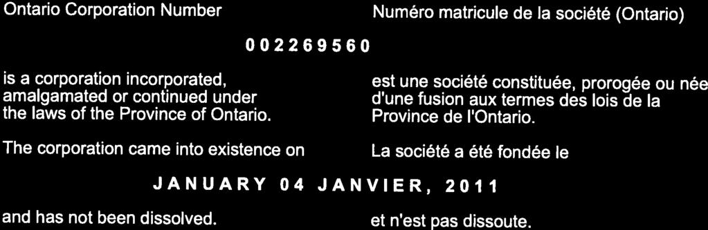
1 Ontario Ministry of the Environment - Record of Site Condition # Record of Site Condition Under Part XV.1 of the Environment Protection Act Summary Record of Site Condition Number Date Filed to Environmental Site Registry 2014/08/15 Certification Date 2014/06/25 Current Property Use Industrial Intended Property Use Residential Certificate of Property Use Number No CPU Applicable Site Condition Standards** Full Depth Generic Site Conditions Standard, with Non-potable Ground Water, for Residential property use Property Municipal Address 147 HARTZEL ROAD, ST. CATHARINES, ON, L2P 1N6, 60 CANTERBURY DRIVE, ST. CATHARINES, ON, L2P 3M8, 58 CANTERBURY DRIVE, ST. CATHARINES, ON, L2P 3M8 Notice to Readers Concerning Due Diligence This record of site condition has been filed in the Environmental Site Registry to which the public has access and which contains a notice advising users of the Environmental Site Registry who have dealings with any property to consider conducting their own due diligence with respect to the environmental condition of the property, in addition to reviewing information in the Environmental Site Registry. Contents of this Record of Site Condition This record of site condition consists (RSC) of this document which is available to be printed directly from the Environmental Site Registry as well as all supporting documentation indicated in this RSC to have been submitted in electronic format to the Ministry of the Environment. Filed Record of Site Condition # on 2014/08/15 1 of 18
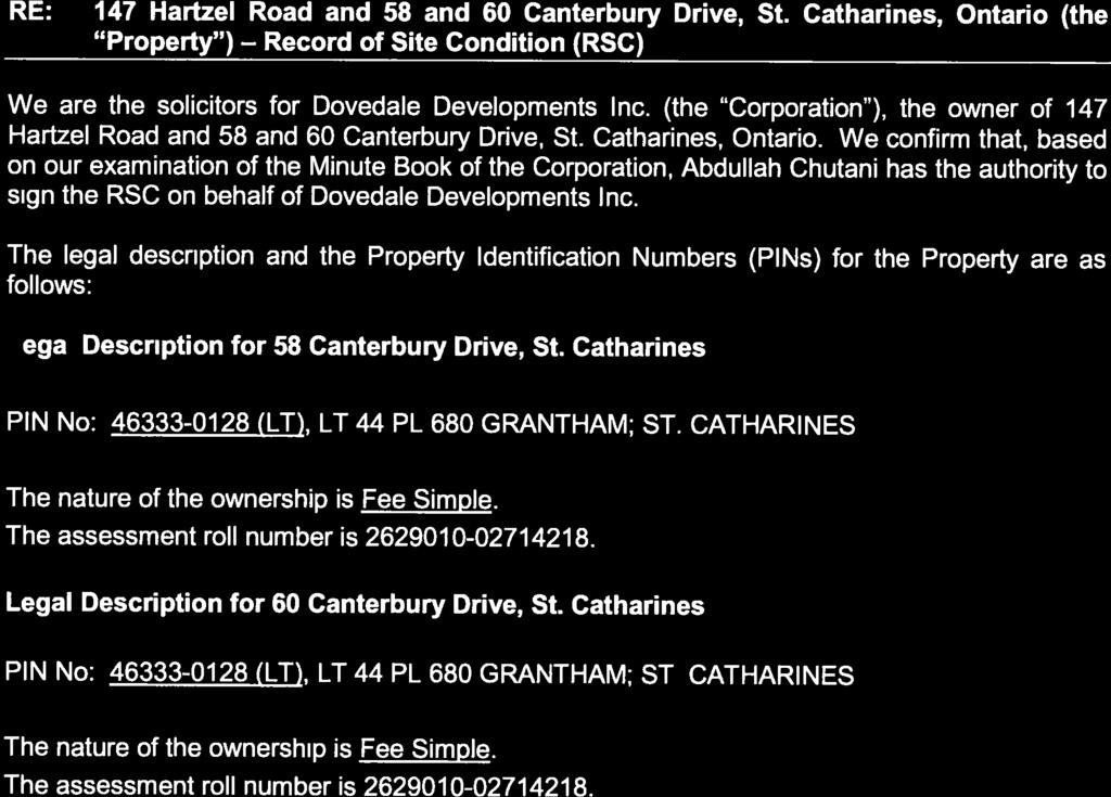
2 PART 1: PROPERTY OWNERSHIP, PROPERTY INFORMATION AND OWNER'S CERTIFICATIONS Information about the owner who is submitting or authorizing the submission of the RSC Owner Name Authorized Person Mailing Address Postal Code DOVEDALE DEVELOPMENTS INC. ABDULLAH CHUTANI 40 VOGELL ROAD, RICHMOND HILL ONTARIO, CANADA L4B 3N6 Phone (905) Fax Address Filed Record of Site Condition # on 2014/08/15 2 of 18
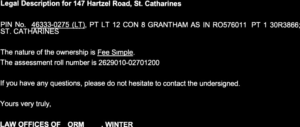
3 RSC Property Location Information Municipal Address(es) Municipality Legal Description Assessment Roll Number(s) 58 CANTERBURY DRIVE, ST. CATHARINES, ON L2P 3M8 60 CANTERBURY DRIVE, ST. CATHARINES, ON L2P 3M8 147 HARTZEL ROAD, ST. CATHARINES, ON L2P 1N6 St. Catharines See Attached Lawyer s Letter Property Identifier Number(s) (LT) (LT) RSC Property Geographical References Coordinate System UTM Datum NAD 83 Zone 17 Easting 645, Northing 4,778, RSC Property Use Information The following types of property uses are defined by the Regulation: Agricultural or other use, Commercial use, Community use, Industrial use, Institutional use, Parkland use, and Residential use. Current Property Use Intended Property Use Certificate of Property Use has been issued under section of the EPA Industrial Residential No Filed Record of Site Condition # on 2014/08/15 3 of 18
4 Please See the Signed Statements of Property Owner, or Agent, or Receiver at the End of this RSC The rest of this page has been left intentionally blank Filed Record of Site Condition # on 2014/08/15 4 of 18
5 PART 2: LIST OF REPORTS, SUMMARY OF SITE CONDITIONS AND QUALIFIED PERSON S STATEMENTS AND CERTIFICATIONS Qualified Person's Information Name Type of Membership Under the Professional Geoscientists Act CARLA REYNOLDS Limited Member Membership Number 1835 QP Employer Name Mailing Address EXP SERVICES INC. 500, 220 COMMERCE VALLEY DRIVE, MARKHAM ONTARIO, L3T 0A8 CANADA Phone (905) Fax (905) Address carla.reynolds@exp.com Municipal Information Local or Single-Tier Municipality Upper-Tier Municipality St. Catharines Niagara Ministry of the Environment District Office District Office District Office Address Niagara District Office 9th floor, 301 St. Paul St., St. Catharines ON L2R 3M8 Filed Record of Site Condition # on 2014/08/15 5 of 18
6 Phase One Environmental Site Assessment Report Document used as the phase one environmental site assessment report and updates in submitting the RSC for filing The date the last work on all of the records review, interviews and site reconnaissance components of the phase one environmental site assessment was done (refer to clause 28(1)(a) of O. Reg. 153/04) (YYYY/MM/DD) 2013/11/01 Type of Report Report Title Date of Report (YYYY/MM/DD) Author of Report Name of Consulting Company P1 ESA Phase One Environmental Site Assessment, 58 and 60 Canterbury Drive and 147 Hartzel Road, St. Catharines, Ontario 2014/02/14 Carla Reynolds, P. Ag., P.Biol., P. Geo.(Limited), QPESA EXP SERVICES INC. Reports and Other Documents Related to the Phase One Environmental Site Assessment Reports and other documents relied upon in certifying the information set out in section 10 of Schedule A or otherwise used in conducting the phase one environmental site assessment Report Title Date of Report (YYYY/MM/DD) Author of Report Name of Consulting Company N/A Filed Record of Site Condition # on 2014/08/15 6 of 18
7 Phase Two Environmental Site Assessment Report Document used as the phase two environmental site assessment report and updates in submitting the RSC for filing The date the last work on all of the planning of the site investigation and conducting the site investigation components of the phase two environmental site assessment was done (refer to clause 33.5(1)(a) of O. Reg. 153/04) (YYYY/MM/DD) 2014/06/26 Type of Report Report Title Date of Report (YYYY/MM/DD) Author of Report Name of Consulting Company P2 ESA Phase Two Environmental Site Assessment, 147 Hartzel Road and 58 and 60 Canterbury Drive, St. Catharines, Ontario 2014/06/27 Carla Reynolds, P. Ag., P.Biol., P. Geo.(Limited), QPESA EXP SERVICES INC. Reports and Other Documents Related to the Phase Two Environmental Site Assessment Reports and other documents relied upon in making any certifications in the RSC for the purposes of Part IV of Schedule A or otherwise used in conducting the phase two environmental site assessment Report Title Date of Report (YYYY/MM/DD) Author of Report Name of Consulting Company N/A Filed Record of Site Condition # on 2014/08/15 7 of 18
8 Environmental Condition Section 41 applies? Section 43.1 applies? No Yes Site Condition Information Certification date (YYYY/MM/DD) 2014/06/25 Total area of RSC property (in hectares) Number of any previously filed RSC that applies to any part of the RSC property Number of any previously filed Transition Notice that applies to any part of the RSC property Soil Texture Assessment/Restoration Approach Site investigation includes the investigation, sampling and analysis of ground water? Is there soil present that is sufficient to investigate, sample and analyze soil on, in or under the property in accordance with s. 6, Schedule E of O.Reg. 153/04? Site investigation includes the investigation, sampling and analysis of soil on, in or under the property which is used in the RSC? Name of the laboratory used to analyze any samples collected of soil, ground water or sediment Ground water condition (potable, non-potable) Full Depth Generic Yes Yes Yes AGAT LABORATORIES Non-potable Applicable Site Condition Standard TABLE 9 Local or single-tier municipality non-potable written notification date 2014/05/20 Upper-tier municipality non-potable written notification date 2014/07/24 Filed Record of Site Condition # on 2014/08/15 8 of 18
9 Table 1 Maximum Contaminant Concentrations Compared to Applicable Site Condition Standards Measured Concentration for Contaminants in Soil Contaminant Name Maximum Concentration Applicable Site Condition Standard Unit of Measure 1 Petroleum Hydrocarbons F1**** < 5 25 µg/g 2 Petroleum Hydrocarbons F2 < µg/g 3 Petroleum Hydrocarbons F3 < µg/g 4 Petroleum Hydrocarbons F4 < µg/g 5 Tetrachloroethane, 1,1,1,2- < µg/g 6 Trichloroethane, 1,1,1- < µg/g 7 Tetrachloroethane, 1,1,2,2- < µg/g 8 Trichloroethane, 1,1,2- < µg/g 9 Dichloroethane, 1,1- < µg/g 10 Dichloroethylene, 1,1- < µg/g 11 Dichlorobenzene, 1,2- < µg/g 12 Dichloroethane, 1,2- < µg/g 13 Dichloropropane, 1,2- < µg/g 14 Dichlorobenzene, 1,3- < µg/g 15 Dichloropropene,1,3- < µg/g 16 Dichlorobenzene, 1,4- < µg/g 17 Acetone < µg/g 18 Benzene < µg/g 19 Bromodichloromethane < µg/g 20 Bromoform < µg/g 21 Bromomethane < µg/g 22 Carbon Tetrachloride < µg/g 23 Chlorobenzene < µg/g 24 Chloroform < µg/g 25 Dichloroethylene, 1,2-cis- < µg/g 26 Dibromochloromethane < µg/g 27 Ethylbenzene < µg/g 28 Ethylene dibromide < µg/g 29 Methyl Ethyl Ketone < µg/g 30 Methyl Isobutyl Ketone < µg/g 31 Methyl tert-butyl Ether (MTBE) < µg/g 32 Methylene Chloride < µg/g 33 Hexane (n) < µg/g 34 Styrene < µg/g 35 Tetrachloroethylene < µg/g 36 Toluene < µg/g 37 Dichloroethylene, 1,2-trans- < µg/g 38 Trichloroethylene < µg/g 39 Vinyl Chloride < µg/g Filed Record of Site Condition # on 2014/08/15 9 of 18
10 39 Vinyl Chloride < µg/g 40 Xylene Mixture < µg/g 41 Dichlorodifluoromethane < µg/g 42 Trichlorofluoromethane < µg/g Filed Record of Site Condition # on 2014/08/15 10 of 18
11 Table 1 Maximum Contaminant Concentrations Compared to Applicable Site Condition Standards (Continued) Ground Water Contaminant Name Maximum Concentration Applicable Site Condition Standard Unit of Measure 1 Petroleum Hydrocarbons F1**** < µg/l 2 Petroleum Hydrocarbons F2 < µg/l 3 Petroleum Hydrocarbons F µg/l 4 Petroleum Hydrocarbons F µg/l 5 Tetrachloroethane, 1,1,1,2- < µg/l 6 Trichloroethane, 1,1,1- < µg/l 7 Tetrachloroethane, 1,1,2,2- < µg/l 8 Trichloroethane, 1,1,2- < µg/l 9 Dichloroethane, 1,1- < µg/l 10 Dichloroethylene, 1,1- < µg/l 11 Dichlorobenzene, 1,2- < µg/l 12 Dichloroethane, 1,2- < µg/l 13 Dichloropropane, 1,2- < µg/l 14 Dichlorobenzene, 1,3- < µg/l 15 Dichloropropene,1,3- < µg/l 16 Dichlorobenzene, 1,4- < µg/l 17 Acetone µg/l 18 Benzene < µg/l 19 Bromodichloromethane < µg/l 20 Bromoform < µg/l 21 Bromomethane < µg/l 22 Carbon Tetrachloride < µg/l 23 Chlorobenzene < µg/l 24 Chloroform < µg/l 25 Dichloroethylene, 1,2-cis- < µg/l 26 Dibromochloromethane < µg/l 27 Dichlorodifluoromethane < µg/l 28 Ethylbenzene < µg/l 29 Ethylene dibromide < µg/l 30 Methyl Ethyl Ketone µg/l 31 Methyl Isobutyl Ketone < µg/l 32 Methyl tert-butyl Ether (MTBE) < µg/l 33 Methylene Chloride < µg/l 34 Hexane (n) < µg/l 35 Styrene < µg/l 36 Tetrachloroethylene < µg/l 37 Toluene < µg/l 38 Dichloroethylene, 1,2-trans- < µg/l 39 Trichloroethylene < µg/l Filed Record of Site Condition # on 2014/08/15 11 of 18
12 39 Trichloroethylene < µg/l 40 Trichlorofluoromethane < µg/l 41 Vinyl Chloride < µg/l 42 Xylene Mixture < µg/l Filed Record of Site Condition # on 2014/08/15 12 of 18
13 Remedial Action and Mitigation Remediated Soils Estimated quantities of the soil, if any, originating at and remaining on the RSC property that have been remediated, at a location either on or off the property, to reduce the concentration of contaminants in the soil. Indicate the remediation process or processes used and the estimated amount of soil remediated by each identified process. Soil Remediation Process Estimated Quantity of Soil (in-ground volume in m³) N/A 0.0 Description of Remediation Description of any action taken to reduce the concentration of contaminants (including soil removals) on, in or under the RSC property. N/A Soil or Sediment Removed and Not Returned Estimated quantities of soil or sediment, if any, removed from and not returned to the RSC property. Estimated Quantity of Soil (in-ground volume in m³) 0.0 Estimated Quantity of Sediment (in-ground volume in m³) 0.0 Soil Brought to the Property Estimated quantity of the soil, if any, being brought from another property to and deposited at the RSC property, not including any soil that may have originated at but been remediated off the RSC property and that is identified in section 28 of Schedule A. Estimated Quantity of Soil Brought to the Property (in-ground volume in m³) 0.0 Filed Record of Site Condition # on 2014/08/15 13 of 18
14 Ground Water Control or Treatment Measures Ground water control or treatment measures that were required for the RSC property prior to the certification date for the purpose of submitting the RSC for filing. N/A Ground water control or treatment measures that are required for the RSC property after the certification date. N/A Estimated volume of ground water, if any, removed from and not returned to the RSC property. Estimated Volume of Ground Water (in litres) 0.0 Filed Record of Site Condition # on 2014/08/15 14 of 18
15 Other Activities Including Risk Management Measures Constructed works that prior to the certification date for the purpose of submitting the RSC for filing, were required to control or otherwise mitigate the release or movement of known existing contaminants at the RSC property. N/A Constructed works that after the certification date, are required to control or otherwise mitigate the release or movement of known existing contaminants at the RSC property. N/A Monitoring or Maintenance Soil Management Measures Soil monitoring requirements or any requirements for care, maintenance or replacement or any monitoring or control works for known existing contaminants, if any, on the RSC property, after the certification date. N/A Ground Water Management Measures Ground water monitoring requirements or requirements for care, maintenance or replacement of any monitoring or control works or known existing contaminants, if any, on the RSC property, after the certification date. N/A Remediated or Removed Soil, Sediment or Ground Water From Near Property Boundary Has any soil, sediment or ground water at the RSC property that is or was located within 3 metres of the RSC property boundary been remediated or removed for the purpose of remediation? No Filed Record of Site Condition # on 2014/08/15 15 of 18
16 Qualified Person s Statements and Certifications As the qualified person, I certify that: A phase one environmental site assessment of the RSC property, which includes the evaluation of the information gathered from a records review, site reconnaissance, interviews, a report and any updates required, has been conducted in accordance with the regulation by or under the supervision of a qualified person as required by the regulation. A phase two environmental site assessment of the RSC property, which includes the evaluation of the information gathered from planning and conducting a site investigation, a report, and any updates required, has been conducted in accordance with the regulation by or under the supervision of a qualified person as required by the regulation. The information represents the site conditions at the sampling points at the time of sampling only and the conditions between and beyond the sampling points may vary. As of 2014/06/25, in my opinion, based on the phase one environmental site assessment and the phase two environmental site assessment, and any confirmatory sampling, there is no evidence of any contaminants in the soil, ground water or sediment on, in or under the RSC property that would interfere with the type of property use to which the RSC property will be put, as specified in the RSC. Ground water sampling has been conducted in accordance with the regulation by or under the supervision of a qualified person as required by the regulation. I have, within the six months immediately before the submission of this record of site condition, given written notice of intention to apply non-potable ground water site condition standards to the clerk of the local municipality in which the property is located and the clerk of any upper-tier municipality in which the property is located. As of 2014/06/25, in my opinion, based on the phase one and phase two environmental site assessments and any confirmatory sampling, the RSC property meets the applicable full depth generic site condition standards prescribed by section 37 of the regulation for all contaminants prescribed by the regulation in relation to the type of property use for which this RSC is filed, except for those contaminants (if any) specified in this RSC at Table 2, Maximum Contaminant Concentrations Compared to Standards Specified in a Risk Assessment. As of 2014/06/25, the maximum known concentration of each contaminant in soil, sediment and ground water at the RSC property for which sampling and analysis has been performed is specified in this RSC at Table 1, Maximum Contaminant Concentrations Compared to Applicable Site Condition Standards. I am a qualified person and have the qualifications required by section 5 of the regulation. I have in place an insurance policy that satisfies the requirements of section 7 of the regulation. I acknowledge that the RSC will be submitted for filing in the Environmental Site Registry, that records of site condition that are filed in the Registry are available for examination by the public and that the Registry contains a notice advising users of the Registry who have dealings with any property to consider conducting their own due diligence with respect to the environmental condition of the property, in addition to reviewing information in the Registry. The opinions expressed in this RSC are engineering or scientific opinions made in accordance with generally accepted principles and practices as recognized by members of the environmental engineering or science profession or discipline practising at the same time and in the same or similar location. I do not hold and have not held and my employer EXP SERVICES INC. does not hold and has not held a direct or indirect interest in the RSC property or any property which includes the RSC property and was the subject of a phase one or two environmental site assessment or risk assessment upon which this record of site condition is based To the best of my knowledge, the certifications and statements in this part of the RSC are true as of 2014/06/25. By signing this RSC, I make no express or implied warranties or guarantees. By checking the boxes above, and entering my membership/licence number in this submission, I, CARLA REYNOLDS, a qualified person as defined in section 5 of O. Reg. 153/04 am, on 2014/08/07: a) signing this record of site condition submission as a qualified person; and b) making all certifications required as a qualified person for this record of site condition. I Agree Filed Record of Site Condition # on 2014/08/15 16 of 18
17 Additional Documentation Provided by Property Owner or Agent The following documents have been submitted to the Ministry of the Environment as part of the record of site condition Certificate of Status or equivalent for the owner Lawyer s letter consisting of a legal description of the property Copy of any deed(s), transfer(s) or other document(s) by which the RSC property was acquired A Current plan of Survey Area(s) of Potential Environmental Concern Table of Current and Past Uses of the Phase One Property Phase 2 Conceptual Site Model Owner or agent certification statements v Filed Record of Site Condition # on 2014/08/15 17 of 18
18 July 17, 2014 July 17, 2014 Filed Record of Site Condition # on 2014/08/15 18 of 18


19

20

21
22 PARCEL REGISTER (ABBREVIATED) FOR PROPERTY IDENTIFIER LAND PAGE 1 OF 1 REGISTRY PREPARED FOR ARamos01 OFFICE # (LT) ON 2014/06/30 AT 10:08:39 * CERTIFIED IN ACCORDANCE WITH THE LAND TITLES ACT * SUBJECT TO RESERVATIONS IN CROWN GRANT * PROPERTY DESCRIPTION: LT 44 PL 680 GRANTHAM; CITY OF ST. CATHARINES PROPERTY REMARKS: ESTATE/QUALIFIER: RECENTLY: PIN CREATION DATE: FEE SIMPLE RE ENTRY FROM /12/22 LT CONVERSION QUALIFIED OWNERS NAMES CAPACITY SHARE DOVEDALE DEVELOPMENTS INC. REG. NUM. DATE INSTRUMENT TYPE AMOUNT PARTIES FROM PARTIES TO CERT/ CHKD ** PRINTOUT INCLUDES ALL DOCUMENT TYPES (DELETED INSTRUMENTS NOT INCLUDED) ** **SUBJECT, ON FIRST REGISTRATION UNDER THE LAND TITLES ACT, TO: ** SUBSECTION 44(1) OF THE LAND TITLES ACT, EXCEPT PARAGRAPH 11, PARAGRAPH 14, PROVINCIAL SUCCESSION DUTIES * ** AND ESCHEATS OR FORFEITURE TO THE CROWN. ** THE RIGHTS OF ANY PERSON WHO WOULD, BUT FOR THE LAND TITLES ACT, BE ENTITLED TO THE LAND OR ANY PART OF ** IT THROUGH LENGTH OF ADVERSE POSSESSION, PRESCRIPTION, MISDESCRIPTION OR BOUNDARIES SETTLED BY ** CONVENTION. ** ANY LEASE TO WHICH THE SUBSECTION 70(2) OF THE REGISTRY ACT APPLIES. **DATE OF CONVERSION TO LAND TITLES: 2003/12/22 ** RO /05/17 AGR SUBDIVISION THE CORPORATION OF THE CITY OF ST. CATHARINES C NR /11/28 TRANS POWER SALE $740, ONTARIO LIMITED DOVEDALE DEVELOPMENTS INC. C REMARKS: NR PLANNING ACT STATEMENTS. 30R /03/07 PLAN REFERENCE C NOTE: ADJOINING PROPERTIES SHOULD BE INVESTIGATED TO ASCERTAIN DESCRIPTIVE INCONSISTENCIES, IF ANY, WITH DESCRIPTION REPRESENTED FOR THIS PROPERTY. NOTE: ENSURE THAT YOUR PRINTOUT STATES THE TOTAL NUMBER OF PAGES AND THAT YOU HAVE PICKED THEM ALL UP.
23 PARCEL REGISTER (ABBREVIATED) FOR PROPERTY IDENTIFIER LAND PAGE 1 OF 2 REGISTRY PREPARED FOR ARamos01 OFFICE # (LT) ON 2014/06/30 AT 10:02:30 * CERTIFIED IN ACCORDANCE WITH THE LAND TITLES ACT * SUBJECT TO RESERVATIONS IN CROWN GRANT * PROPERTY DESCRIPTION: PT LT 12 CON 8 GRANTHAM AS IN RO576011, PT 1 30R3866; CITY OF ST. CATHARINES PROPERTY REMARKS: PLANNING ACT CONSENT AS IN RO PLANNING ACT CONSENT AS IN RO PLANNING ACT CONSENT AS IN RO ESTATE/QUALIFIER: RECENTLY: PIN CREATION DATE: FEE SIMPLE RE ENTRY FROM /12/22 LT CONVERSION QUALIFIED OWNERS NAMES CAPACITY SHARE DOVEDALE DEVELOPMENTS INC. REG. NUM. DATE INSTRUMENT TYPE AMOUNT PARTIES FROM PARTIES TO CERT/ CHKD ** PRINTOUT INCLUDES ALL DOCUMENT TYPES (DELETED INSTRUMENTS NOT INCLUDED) ** **SUBJECT, ON FIRST REGISTRATION UNDER THE LAND TITLES ACT, TO: ** SUBSECTION 44(1) OF THE LAND TITLES ACT, EXCEPT PARAGRAPH 11, PARAGRAPH 14, PROVINCIAL SUCCESSION DUTIES * ** AND ESCHEATS OR FORFEITURE TO THE CROWN. ** THE RIGHTS OF ANY PERSON WHO WOULD, BUT FOR THE LAND TITLES ACT, BE ENTITLED TO THE LAND OR ANY PART OF ** IT THROUGH LENGTH OF ADVERSE POSSESSION, PRESCRIPTION, MISDESCRIPTION OR BOUNDARIES SETTLED BY ** CONVENTION. ** ANY LEASE TO WHICH THE SUBSECTION 70(2) OF THE REGISTRY ACT APPLIES. **DATE OF CONVERSION TO LAND TITLES: 2003/12/22 ** RO /08/31 AGREEMENT C RO /01/22 AGREEMENT C 30R /08/22 PLAN REFERENCE C 30R /10/01 PLAN REFERENCE C RO /06/03 AGREEMENT C 30R /05/15 PLAN REFERENCE C RO /06/14 AGREEMENT CITY OF ST. CATHARINES C RO /07/05 RELEASE C RO /02/20 AGREEMENT C NOTE: ADJOINING PROPERTIES SHOULD BE INVESTIGATED TO ASCERTAIN DESCRIPTIVE INCONSISTENCIES, IF ANY, WITH DESCRIPTION REPRESENTED FOR THIS PROPERTY. NOTE: ENSURE THAT YOUR PRINTOUT STATES THE TOTAL NUMBER OF PAGES AND THAT YOU HAVE PICKED THEM ALL UP.

24 PARCEL REGISTER (ABBREVIATED) FOR PROPERTY IDENTIFIER LAND PAGE 2 OF 2 REGISTRY PREPARED FOR ARamos01 OFFICE # (LT) ON 2014/06/30 AT 10:02:30 * CERTIFIED IN ACCORDANCE WITH THE LAND TITLES ACT * SUBJECT TO RESERVATIONS IN CROWN GRANT * REG. NUM. DATE INSTRUMENT TYPE AMOUNT PARTIES FROM PARTIES TO CERT/ CHKD NR /11/28 TRANS POWER SALE $740, ONTARIO LIMITED DOVEDALE DEVELOPMENTS INC. C REMARKS: NR PLANNING ACT STATEMENTS. 30R /03/07 PLAN REFERENCE C NOTE: ADJOINING PROPERTIES SHOULD BE INVESTIGATED TO ASCERTAIN DESCRIPTIVE INCONSISTENCIES, IF ANY, WITH DESCRIPTION REPRESENTED FOR THIS PROPERTY. NOTE: ENSURE THAT YOUR PRINTOUT STATES THE TOTAL NUMBER OF PAGES AND THAT YOU HAVE PICKED THEM ALL UP.
25 LRO # 30 Transfer: Power Of Sale Receipted as NR on at 12:37 The applicant(s) hereby applies to the Land Registrar. yyyy mm dd Page 1 of 3 Properties PIN LT Interest/Estate Fee Simple Description LT 44 PL 680 GRANTHAM; ST. CATHARINES Address ST. CATHARINES PIN LT Interest/Estate Fee Simple Description PT LT 12 CON 8 GRANTHAM AS IN RO576011, PT 1 30R3866; ST. CATHARINES Address ST. CATHARINES Source Instruments Registration No. Date Type of Instrument NR Charge/Mortgage Consideration Consideration $740, Transferor(s) The transferor(s) hereby transfers the land to the transferee(s). Name Address for Service ONTARIO LIMITED 7635 Keele Street Concord, Ontario L4K 1Y4 I, Melvyn Solmon have the authority to bind the corporation. This document is not authorized under Power of Attorney by this party. Transferee(s) Capacity Share Name Address for Service DOVEDALE DEVELOPMENTS INC. 40 Vogell Road Suite 13 Richmond Hill, ON L4B 3N6 Statements The document is authorized under the charge and the Mortgages Act. The sale proceedings and transfer comply with the charge, the Mortgages Act, and if applicable the Bankruptcy and Insolvency Act (Canada), the Condominium Act, the Construction Lien Act and the Farm Debt Mediation Act (Canada). The charge was in default at the time notice of sale was given and continues to be in default and the money has been advanced under the charge. There are no encumbrances to be deleted This transaction is not subject to any writs of execution Title to the land is not subject to spousal rights under the Family Law Act Schedule: THE NOTICE OF SALE WAS GIVEN ON JULY 15, 2009 STATEMENT OF THE TRANSFEROR (S): The transferor(s) verifies that to the best of the transferor s knowledge and belief, this transfer does not contravene the Planning Act. STATEMENT OF THE SOLICITOR FOR THE TRANSFEROR (S): I have explained the effect of the Planning Act to the transferor(s) and I have made inquiries of the transferor(s) to determine that this transfer does not contravene that Act and based on the information supplied by the transferor(s), to the best of my knowledge and belief, this transfer does not contravene that Act. I am an Ontario solicitor in good standing. STATEMENT OF THE SOLICITOR FOR THE TRANSFEREE (S): I have investigated the title to this land and to abutting land where relevant and I am satisfied that the title records reveal no contravention as set out in the Planning Act, and to the best of my knowledge and belief this transfer does not contravene the Planning Act. I act independently of the solicitor for the transferor(s) and I am an Ontario solicitor in good standing. Signed By Avrum David Slodovnick 375 University Ave., Suite 701 Toronto M5G 2J5 acting for Transferor(s) Signed
26 LRO # 30 Transfer: Power Of Sale Receipted as NR on at 12:37 The applicant(s) hereby applies to the Land Registrar. yyyy mm dd Page 2 of 3 Signed By Tel Fax I am the solicitor for the transferor(s) and I am not one and the same as the solicitor for the transferee(s). I have the authority to sign and register the document on behalf of the Transferor(s). Norman Winter Tel Fax St. Clair Av. East Toronto M4T 2V7 acting for Transferee(s) I am the solicitor for the transferee(s) and I am not one and the same as the solicitor for the transferor(s). I have the authority to sign and register the document on behalf of the Transferee(s). Signed Submitted By NORMAN WINTER Tel Fax St. Clair Av. East Toronto M4T 2V Fees/Taxes/Payment Statutory Registration Fee $60.00 Provincial Land Transfer Tax $11, Total Paid $11, File Number Transferor Client File Number : 17235
27 LAND TRANSFER TAX STATEMENTS In the matter of the conveyance of: LT 44 PL 680 GRANTHAM; ST. CATHARINES PT LT 12 CON 8 GRANTHAM AS IN RO576011, PT 1 30R3866; ST. CATHARINES BY: TO: ONTARIO LIMITED DOVEDALE DEVELOPMENTS INC. 1. ABDULLAH CHUTANI I am (a) A person in trust for whom the land conveyed in the above described conveyance is being conveyed; (b) A trustee named in the above described conveyance to whom the land is being conveyed; (c) A transferee named in the above described conveyance; (d) The authorized agent or solicitor acting in this transaction for described in paragraph(s) (_) above. (e) The President, Vice President, Manager, Secretary, Director, or Treasurer authorized to act for DOVEDALE DEVELOPMENTS INC. described in paragraph(s) (c) above. (f) A transferee described in paragraph() and am making these statements on my own behalf and on behalf of who is my spouse described in paragraph(_) and as such, I have personal knowledge of the facts herein deposed to. 2. I have read and considered the definition of "single family residence" set out in subsection 1(1) of the Act. The land being conveyed herein: contains at least one and not more than two single family residences. 3. The total consideration for this transaction is allocated as follows: (a) Monies paid or to be paid in cash 150, (b) Mortgages (i) assumed (show principal and interest to be credited against purchase price) 0.00 (ii) Given Back to Vendor 590, (c) Property transferred in exchange (detail below) 0.00 (d) Fair market value of the land(s) 0.00 (e) Liens, legacies, annuities and maintenance charges to which transfer is subject 0.00 (f) Other valuable consideration subject to land transfer tax (detail below) 0.00 (g) Value of land, building, fixtures and goodwill subject to land transfer tax (total of (a) to (f)) 740, (h) VALUE OF ALL CHATTELS items of tangible personal property 0.00 (i) Other considerations for transaction not included in (g) or (h) above 0.00 (j) Total consideration 740, PROPERTY Information Record A. Nature of Instrument: Transfer: Power Of Sale LRO 30 Registration No. NR Date: 2013/11/28 B. Property(s): PIN Address ST. CATHARINES Assessment Roll No PIN Address ST. CATHARINES Assessment Roll No C. Address for Service: 40 Vogell Road Suite 13 Richmond Hill, ON L4B 3N6 D. (i) Last Conveyance(s): PIN Registration No. NR95297 PIN Registration No. NR95297 (ii) Legal Description for Property Conveyed: Same as in last conveyance? Yes No Not known E. Tax Statements Prepared By: Norman Winter St. Clair Av. East Toronto M4T 2V7
28 PHASE ONE, PHASE TWO AND RSC PROPERTY BOUNDARY
29 TABLE OF AREAS OF POTENTIAL ENVIRONMENTAL CONCERN 58 and 60 Canterbury Drive and 147 Hartzel Road, St. Catharines Project# MRK A0 Record of Site Condition Filing Table of Areas of Potential Environmental Concern APEC Location of APEC on Phase One Property PCA Location of PCA (onsite or offsite) Contaminants of Potential Environmental Concern Media Potentially Impacted (Ground water, soil, and/or sediment) A Central portion of the property addressed as 147 Hartzel Road (28) Gasoline and Associate Products Storage in Fixed Tanks S10On0site VOCs, PHCs Soil and Ground Water Note: No sediment was present at the subject property.
30 TABLE OF CURRENT AND PAST USES OF THE PHASE ONE PROPERTY 147 Hartzel Road and 58 and 60 Canterbury Drive, St. Catharines, Ontario Project #: MRK AO Table of Current and Past Uses of the Phase One Property Year Name of Owner Description of Property Use Property Use Other Observations from previous reports, aerial photographs, etc 147 Hartzel Road ' PIN 46333'0275 (LT) Prior to November 1867 George H. Standbrooke Livestock pens, butcher and meat packing November 1867 to David W. Corbin August 1878 August 1878 to John Pattison November 1889 November 1889 to James Prior October 1925 October 1925 to October Oscar Jacobson 1930 Industrial The Chain of Title search indicates that the property was owned by individuals during this period. Two small buildings that appear to be farm related structures are visible on the site in the 1934 aerial photograph. Fence lines, building configurations and ground wear patterns on the site are consistent with livestock paddocks and farm structures. An unaddressed listing on Hartzel Road for Jacobson and Se1burn Butchers is identified in the 1928 City Directory. The property uses associated with on1site activities are agricultural and commercial (butcher) and industrial (meat packing). Surrounding areas to the north, east and south of the site appear to be in use as agricultural fields. Rockwood Creek is visible to the west of the site in aerial photographs. West portion of 147 Hartzel Road ' PIN 46333'0275 (LT) October 1930 to August 1939 August 1939 to October 1942 October 1942 to July 1946 July 1946 to June 1954 Imperial Bank of Commerce Livestock pens, butcher and meat packing William Winters Charles A Sebura Jones Packing Company Industrial Mortgage Default Property split into two parcels (west portion includes 147 Hartzel Road; east portion appears to includes a portion of the right of way access). The previous property uses associated with on1site activities, including agricultural and commercial (butcher) and industrial (meat packing), continued after the mortgage default. The 1962/1963 Fire Insurance Plan (FIP) depicts two structures on the site in the same configuration as the 1934 aerial photographs. The north building is described as a pig pen, and the south building is described as a slaughter floor and cold storage. The 1977 FIP indicates the north barn structure was in use as a hen house, and the south building included stock pens, slaughter area, 1
31 TABLE OF CURRENT AND PAST USES OF THE PHASE ONE PROPERTY 147 Hartzel Road and 58 and 60 Canterbury Drive, St. Catharines, Ontario Project #: MRK AO Year Name of Owner Description of Property Use Property Use Other Observations from previous reports, aerial photographs, etc June 1954 to December 1968 December 1968 to November 1988 Albert C. Willis, Joseph Robian Grantham Packers Limited Livestock pens, butcher and meat packing facility Industrial meat1cutting and grinding area, butcher area and freezers. The one1storey south structure is reportedly of slab1on1 grade construction. A boiler was identified on the north portion of the building in the 1962/1963 FIP. Based on the street directory searches, 1934 aerial photograph, and 1962/63 and 1977 FIPs, the site is determined to have been in continuous use for agricultural and commercial activities (butcher) and meat packing (industrial) during this period. An APEC related to the potential for storage of gasoline and related products in fixed tanks (boiler) is identified on the central portion of the site. November 1988 to February 2006 February 2006 to November 2013 November 2013 to present Ontario Limited Vacant Industrial The site buildings were demolished in the 1980s. Site reconnaissance, interviews, and aerial photographs Ontario Inc. confirm that the site has remained vacant since the 1980s. Dovedale Developments Inc. No APECs were identified on the site during this period. East parcel, Right of Way Access to 147 Hartzel Road ' PIN 46333'0275 (LT) October 1930 to September 1941 Imperial Bank of Canada Gravel two1track private right of way access from Hartzel Road to site Community Mortgage Default Property split into two parcels (west portion includes 147 Hartzel Road; east portion appears to includes a portion of the right of way access). September 1941 to September 1968 Aiken and MacLachlan Limited The Chain of Title indicates that this parcel of the property was owned by Aiken and MacLauchlan contractors in the 1940s through 1960s. Aiken and MacLachlan operated a contracting business located southeast of the site at 149 Hartzel Avenue (1962/1963 FIP). The Aiken and MacLachlan property appears to overlap with a portion of the gravel two1track laneway that is the right of way access to the property at 147 Hartzel Road. September 1968 to April 1969 Raymond Washuta and Michael Washuta Based on the street directory searches, 1934 aerial photograph, and 1962/63 and 1977 FIPs, this portion of the site is determined to have been in continuous use for commercial and/or community purposes during this period. 2
32 TABLE OF CURRENT AND PAST USES OF THE PHASE ONE PROPERTY 147 Hartzel Road and 58 and 60 Canterbury Drive, St. Catharines, Ontario Project #: MRK AO Year Name of Owner Description of Property Use Property Use Other Observations from previous reports, aerial photographs, etc April 1969 to November 1988 November 1988 to February 2006 February 2006 to November 2013 November 2013 to present Grantham Packers Limited No APECs were identified on this portion of the site Ontario Limited Vacant Community The site buildings were demolished in the 1980s. Site reconnaissance, interviews, and aerial photographs confirm that the site has remained vacant since the 1980s Ontario Inc. No APECs were identified on the site during this period. Dovedale Developments Inc. 58 and 60 Canterbury Drive ' PIN 46333'0128 (LT) February 1869 to March 1901 March 1901 to November 1912 Thomas McCarthy Agricultural fields Agricultural The Chain of Title search indicates that the property was owned by individuals during this period. The site appears to be in use as part of a recently plowed agricultural field in Joseph Smith the 1934 aerial photograph. No structures were present on the site. Surrounding areas to the north, east and south of the site appear to be in use as agricultural fields. 3
33 TABLE OF CURRENT AND PAST USES OF THE PHASE ONE PROPERTY 147 Hartzel Road and 58 and 60 Canterbury Drive, St. Catharines, Ontario Project #: MRK AO Year Name of Owner Description of Property Use Property Use Other Observations from previous reports, aerial photographs, etc November 1912 to March 1939 James Vine No APECs were identified on the site during this period. March 1939 to February 1952 February 1952 to August 1970 August 1970 to March 1973 Corporation of the Township of Grantham Lightning Fastener Company Limited/ Chardana Hotel Limited Chardana Investments Limited Vacant Agricultural The Chain of Title search indicates that the property was assumed by the Township of Grantham in 1939 for taxes in arrears. No evidence of development during this period. No APECs were identified on the site during this period. Vacant Vacant Agricultural Agricultural The Chain of Title search indicated a name change was filed from Lightening Fastener Company Limited to Chardana Hotel Limited on November 27, The area appears vacant in the 1962/1963 FIP. There was no evidence reviewed in the Phase One ESA (Street Directory Searches, FIPs, aerial photographs, interviews) to suggest the site was occupied by any permanent structures during this period. March 1973 to May 1974 Langendoen Investments Limited; Birchwood Builders Limited; Berol Development Limited; Ace Developments May 1974 to July 1974 Birchwood Builders Limited; Berol Developments Limited; Langendoen; Paramount Properties Company July 1974 to August 1974 Birchwood Builders (St. Catharines) Limited August 1974 to September 1975 September 1975 to July 1979 July 1979 to June 1983 Undergoing development as part of a residential subdivision Residential Sidney M. Fawcett Residential Residential Gerrard McGeachy William C. Garner and Teresa D. Garner No APECs were identified on the site during this period. The Chain of Title indicates the property was held under partial to complete ownership by Birchwood Builders from 1973 to 1974, when it was assumed under individual ownership. Site addresses 58 and 60 Canterbury Drive were first listed as residential in the 1975 City Directory. A residential development consistent with the present property configuration is apparent in the 1983 aerial photograph. A rectangular structure consistent with the residence at 58/60 Canterbury Drive is evident in the 1983 aerial photograph. The property has been under continuous residential occupancy since the early 1970s, including provision of municipal services. No above ground storage tanks or underground storage tanks were present on the site. The property has been rented for residential purposes from 1988 to the present, as indicated during interviews and site reconnaissance. No APECs were identified on the site during this period. 4
34 TABLE OF CURRENT AND PAST USES OF THE PHASE ONE PROPERTY 147 Hartzel Road and 58 and 60 Canterbury Drive, St. Catharines, Ontario Project #: MRK AO Year Name of Owner Description of Property Use Property Use Other Observations from previous reports, aerial photographs, etc June 1983 to August 1986 August 1986 to November 1988 November 1988 to February 2006 February 2006 to November 2013 November 2013 to present Thomas W. Goldfinch and Vicki L. Fraser Joseph Miaotto and Noreen Miotto Ontario Limited Ontario Inc. Dovedale Developments Inc. 5
35 PHASE TWO CONCEPTUAL SITE MODEL 58 and 60 Canterbury Drive and 147 Hartzel Road, St. Catharines, Ontario Project# MRK/ /A0 Record of Site Condition Filing 1.0 Phase Two Conceptual Site Model Exp Services Inc. was retained by Dovedale Developments Inc. to conduct a Phase Two Environmental Site Assessment (ESA) for the site municipally addressed as 58 and 60 Canterbury Drive and 147 Hartzel Road in St. Catharines, Ontario (herein referred to as the RSC property or site ). The site measures approximately 0.85 hectares. The legal description of the RSC property is: 58 Canterbury Drive, St. Catharines Legal Description: LOT 44, PLAN 680, GRANTHAM, CITY OF ST. CATHARINES PIN: 46333/0128 (LT) Assessment Roll Number: / Canterbury Drive, St. Catharines Legal Description: LOT 44, PLAN 680, GRANTHAM, CITY OF ST. CATHARINES PIN: 46333/0128 (LT) Assessment Roll Number: / Hartzel Road, St. Catharines Legal Description: PART OF LOT 12, CONCESSION 8, TOWNSHIP OF GRANTHAM, AS IN RO576011, PART 130R3866, ST. CATHARINES PIN: 46333/0275 (LT) Assessment Roll Number: / Potentially Contaminating Activities Based on the findings of the Phase One investigation conducted by exp in 2013, the former land use included livestock pens (agricultural land use), butcher (commercial land use), meat packing and cold storage (industrial land use). The following potentially contaminating activity (PCA) was identified at the site within the Phase One Study Area. (28) Potential gasoline and associated products storage in fixed tanks, related to the presence of a boiler in the north portion of the building. The number presented beside the PCA is associated with the PCA number in Table 2 of Schedule D of O.Reg. 153/04. No evidence of imported fill was observed during the Phase One site reconnaissance or during Phase Two drilling activities. 1
36 PHASE TWO CONCEPTUAL SITE MODEL 58 and 60 Canterbury Drive and 147 Hartzel Road, St. Catharines, Ontario Project# MRK/ /A0 Record of Site Condition Filing 1.2 Areas of Potential Environmental Concern Exp conducted a Phase One EA for the RSC property in 2013, summarizing the current and historical sources of information. One area of potential environmental concern (APEC) was identified on the central portion of the site, based on the former location of a boiler, located in the north portion of the main building. A fuel source was not determined, and fuel oil was considered to be a potential contaminant of concern (COC). The location of the APEC is illustrated on Figures 2 and 3, attached. Table 1 Areas of Potential Environmental Concern APEC 1 Location of APEC on Phase One Property PCA Location of PCA (on0site or off0site) Contaminants of Potential Environmental Concern Media Potentially Impacted (Ground water, soil, and/or sediment) A Butcher/ packing building, central portion of site (28) Potential Gasoline and Associate Products Storage in Fixed Tanks On/site VOCs, PHCs Soil and ground water Note: No sediment was present at the subject property. The PCA contributing to a potential APEC is described below: (28) Potential Gasoline and Associate Products Storage in Fixed Tanks A boiler was formerly located in the north portion of the former meat packing facility. Though no evidence of tanks was identified, the fuel source of the boiler could not conclusively be determined. The potential for petroleum based fuel was identified as a COC. Activities identified within the building included holding pens, slaughter, scalding, butcher, meat cutting and grinding, processing, freezers, storage, lunch room, and lavatory. Based on the size of the building and a review of these processes in the 1920s through 1970s, it is unlikely that this was a heavily mechanized facility. Most of the butchering would have been accomplished using handheld power saws. An APEC was identified on the central portion of the site. The potential contaminants of concern (pcocs) associated with this APEC were volatile organic compounds (VOCs) and petroleum hydrocarbon (PHC) fractions F1 to F4. 2
37 PHASE TWO CONCEPTUAL SITE MODEL 58 and 60 Canterbury Drive and 147 Hartzel Road, St. Catharines, Ontario Project# MRK/ /A0 Record of Site Condition Filing 2.0 Physical Setting The site is located in the physiographic region known as the Iroquois Plain, consisting of glaciolacustrine sand and silt deposits. The layer is underlain by Halton Till, glaciolacustrine deposits of clay and silt, and Upper Ordovician red shale, (Physiography of Southern Ontario, Chapman and Putnam, 1984). The native soil beneath the site was reported in the well record logs to consist of gravel, sand and/or silt underlain by clay, as expected in this physiographic region. Based on the results of the Phase Two investigation, the site stratigraphy is determined to be 1 to 2 centimetres of topsoil or gravel over silty clay to a maximum depth of 3.0 metres below ground surface (mbgs), underlain by clay to a depth greater than 9.1 mbgs. Bedrock was not encountered during the investigation. With respect to Section 43.1 of the O.Reg.153/04, the subject property is not considered to be a shallow soil property. According to the Geological Survey of Canada map of the area (Southern Ontario, 1:1,000,000 Scale, Sheet SSS, Map 2544), the underlying geology comprises the Queenston Formation, characterized by Upper Ordovician red shale, limestone, dolostone, and siltstone (Bedrock Geology of Ontario Southern Sheet, Map 2544, Ministry of Northern Development and Mines). The depth to bedrock is approximately 30 to 40 metres below ground surface (mbgs) (Bedrock Topography and Overburden Thickness Mapping, Southern Ontario; Ontario Geological Survey, Data 207, 2006). A map of the site from the Natural Resources Atlas of Canada was reviewed. The topographic contour lines confirm that ground water is expected to flow northeast towards Lake Ontario and the Welland River/Canal. The ground water table was measured between 1.02 to 5.50 mbgs in the native clay. The measured ground water flow direction beneath the site was to the southeast. The hydraulic gradient was calculated to be 0.05 m/m, based on ground water contours. Due to the very low hydraulic conductivity associated with the native clay, it is likely that the ground water levels have not achieved equilibrium with the aquifer. The estimated hydraulic conductivity of the native clay was 1x10 /7 cm/sec, based on published literature (Freeze and Cherry, 1979). Due to the extremely low hydraulic conductivity of the native soil at the site, a bailer test could not be performed. Darcy s Law was used to calculate an average linear ground water flow velocity of 3.15x10 /3 metres per year, assuming a horizontal hydraulic gradient of 0.05 m/m and a porosity of 50%. The southeasterly ground water flow direction and hydraulic gradient were determined from measurements obtained by exp staff on May 27, 2014 and confirmed on June 30, Ground water contours are illustrated in Figure 8. There are no surface water bodies on the site. The nearest surface water body is Rockwood Creek, located approximately 25 metres west of the Site. The Welland River/Canal is located 1.7 kilometres east of the site. Lake Ontario is located approximately 7.0 kilometres north of the site. The site is located within the Welland Creek Subwatershed, which comprises part of the Twelve Mile Creek Watershed. Based on the distance to Rockwood Creek to the west, the site includes land within 30 metres of a water body as defined in O.Reg. 153/04, Section The site is not considered to be a sensitive site, as defined in O.Reg. 153/04, Section 41, for the following reasons: The site does not include and is not within 30 metres of an area of natural significance and soil samples had a ph of between 5 and 9. As a result, the Table 9 Standards for land within 30 metres of a water body are appropriate for the site. 3
38 PHASE TWO CONCEPTUAL SITE MODEL 58 and 60 Canterbury Drive and 147 Hartzel Road, St. Catharines, Ontario Project# MRK/ /A0 Record of Site Condition Filing No evidence of potential imported soil was identified at the site during the Phase One ESA site reconnaissance or the Phase Two ESA drilling activities. The locations of the existing duplex residence (58 and 60 Canterbury Drive), former animal pens and former butcher floor and meat packing area are illustrated on Figure 2, attached. A proposed low/rise residential development is currently under consideration for the entire site. 3.0 Current Site Status 3.1 Soil Five soil samples, including one field duplicate sample, were collected from TH1, TH2, TH3 and TH1B at depths ranging from grade to 9.1 mbgs. Soil samples were submitted to AGAT for analysis of the potential COCs including VOCs and PHC fractions F1 to F4. All soil samples were within the MOE Table 9 Standards for all parameters analyzed. The results of the current investigation do not indicate the presence of light or dense non/aqueous phase liquids, nor were contaminants related to chemical and biological transformations identified at the selected sampling locations. The soil results do not suggest a potential source of contaminant mass contributing to the local ground water beneath the Phase Two property. 3.2 Ground Water Seven ground water samples, including three field duplicate samples, were collected at depths ranging from 6.1 to 9.1 mbgs at TH2 and TH3, 1.6 to 3.0 mbgs at TH1B, and 0.9 to 3.9 mbgs at TH2B andth3b. The samples were submitted to AGAT for chemical analysis of VOCs and PHC fractions F1 to F4. A field blank, trip blank, and trip spike were submitted for analysis of BTEX and VOCs. Samples were not field filtered. The ground water samples collected from monitors TH1B, TH3B, TH2, and TH3 were within the MOE Table 9 Standards for all of the parameters analyzed. All QA/QC samples were within the alert criteria. The results of the current investigation do not indicate the presence of light or dense non/aqueous phase liquids, nor were contaminants related to chemical and biological transformations identified at the selected sampling locations. The ground water results do not suggest any potential source of contaminant mass contributing to the local ground water beneath the Phase Two property. No sediment was present at the site. 4.0 Relevant Construction Features and HVAC The duplex residence, located on the 0.05 hectare parcel of land addressed as 58 and 60 Canterbury Drive, includes one level of subgrade basement. Each residential unit is heated by a forced air residential/grade gas furnace, located in the basement. Ground/mounted air conditioning units were observed for each of the two residential units during the Phase One ESA site reconnaissance. 4
39 PHASE TWO CONCEPTUAL SITE MODEL 58 and 60 Canterbury Drive and 147 Hartzel Road, St. Catharines, Ontario Project# MRK/ /A0 Record of Site Condition Filing No structures are currently present on the parcel at 147 Hartzel Road. A review of historic documents indicates that the former pig pen (circa 1962)/ hen house (circa 1977) was a wood frame structure, having dimensions of approximately 15 m x 10 m in The main building, containing a slaughter room, butcher area and three freezers, had a total footprint of approximately 20 m x 30 m in The building was reportedly of wood frame, wood joist, single/storey, concrete slab/on/grade construction. Evidence of the floor slab was observed during the Phase One ESA. No evidence of subgrade structures was observed during the Phase One historical records review, site reconnaissance, or Phase Two ESA. 5.0 Subsurface Utilities Public and private utility locates were reviewed as part of the Phase Two ESA. Given the depth of the water table measured during the investigation (1.02 to 5.50 mbgs in the native clay layer), the ground water flow direction may be influenced by the underground utilities or the basements of the on/site buildings on the north portion of the site (58 and 60 Canterbury Drive). One level of subgrade basement is present beneath the residence located at 58 and 60 Canterbury Drive, on the northeast portion of the site. The residences are serviced with municipal water, storm sewers and sanitary sewers supplied by the City of St. Catharines, natural gas service is provided by Enbridge, and hydro electric utilities are provided by Horizon Utilities. Services are located beneath Canterbury Drive, and access the northeast portion of the site at 58 and 60 Canterbury Drive from the west property boundary. Currently, no active subsurface utilities are known to be present beneath the vacant portion of the site addressed as 147 Hartzel Road. The construction of the former butcher/meat packing facility was slab/ on/grade; no evidence of subgrade structures associated with this portion of the site were observed or suspected. As the majority of the site is located greater than 90 metres west of Hartzel Road, it is unlikely that subsurface utility corridors beneath the roadway will have an impact on the flow regime beneath the bulk of the site. As ground water parameters were within the MOE Table 9 Standards for all parameters analyzed, distribution of ground water contamination beneath the site is not a concern. 6.0 Uncertainty in the Phase Two Investigation The investigation undertaken by exp with respect to this investigation and any conclusions or recommendations resulting from the work reflect exp s judgment based on the site conditions observed at the time of the site inspection on the date(s) set out in the report, and on information available at the time of preparation of this work. Exp has confirmed neither the completeness nor the accuracy of the records that were provided by others; as such, the historical records review is identified as a potential source of uncertainty during the investigation. The CSM is developed using multiple lines of evidence, searches and source information to make every reasonable attempt to ensure that findings of environmental significance are captured. Any uncertainty or absence of information in the records review, interviews, and site reconnaissance components of the Phase One investigation, or any uncertainty or absence of information within the Phase Two investigation, including but not limited to the uncertainty with respect to the ground water flow 5
40 PHASE TWO CONCEPTUAL SITE MODEL 58 and 60 Canterbury Drive and 147 Hartzel Road, St. Catharines, Ontario Project# MRK/ /A0 Record of Site Condition Filing direction, are not anticipated to materially affect the validity of the conceptual site model (CSM) or Phase Two conclusions. 6

41 SITE Parkwood Dr Lonsdale Ave Admiral Rd SCALE: 0 500m SOURCE: YAHOO MAPS LOCALITY PLAN FIGURE 1 DRAWN BY CHECKED BY N 147 HARTZEL ROAD and 58/60 CANTERBURY DRIVE, ST. CATHARINES, ONTARIO M.W. J.S. JOB NUMBER: DATE: MARCH LOCALITY

42 INFERRED REGIONAL GROUND WATER FLOW DIRECTION PHASE ONE STUDY AREA RESIDENTIAL 1 BURNESS DR RESIDENTIAL 2 DUNVEGAN RD RESIDENCE 58/60 CANTERBURY DRIVE MEASURED GROUND WATER FLOW DIRECTION PHASE ONE PROPERTY BOUNDARY 3PARKWOOD DR FORMER PIG PEN FORMER SLAUGHTER AND COLD STORAGE BUILDING 4 COMMERCIAL HARTZEL ROAD LONSDALE AVE RAILWAY ADMIRAL RD RESIDENTIAL ROCKWOOD CREEK COMMERCIAL Table of Potentiall Contaminating Activity 1 Gasoline Underground Storage Tank 2 Gasoline Underground Storage Tank 3 Gasoline Underground Storage Tank 4 Former Boiler, Potential for Former Storage Tank N SCALE: m CSM DRAWN BY: M.W. CHECKED BY: A.B. SOURCE: GOOGLE EARTH AND FIELD MEASUREMENTS BY exp STAFF LEGEND: SITE BOUNDARY EXISTING RESIDENCE FORMER BUILDING FOOTPRINT GASOLINE AND ASSOCIATED PRODUCTS IN FIXED TANKS PHASE ONE CONCEPTUAL SITE MODEL 147 HARTZEL ROAD and 58/60 CANTERBURY DRIVE, ST CATHARINES, ONTARIO JOB NUMBER: DATE: JUNE 2014 FIGURE 2
Record of Site Condition For Part XV.1 of the Environmental Protection Act
 Summary Record of Site Condition For Part XV.1 of the Environmental Protection Act Registration Number 51516 Status Submitted Submit Date 2009/04/03 Certification Date 2008/04/24 Current Property Use Intended
Ontario Ministry of the Environment - Record of Site Condition # Record of Site Condition Under Part XV.1 of the Environment Protection Act
 Ontario Ministry of the Environment - Record of Site Condition # 202807 Record of Site Condition Under Part XV.1 of the Environment Protection Act Summary Record of Site Condition Number 202807 Date Filed
Ontario Ministry of the Environment and Climate Change - Record of Site Condition #
 Ontario Ministry of the Environment and Climate Change - Record of Site Condition # 218489 Record of Site Condition Under Part XV.1 of the Environment Protection Act Summary Record of Site Condition Number
Ontario Ministry of the Environment and Climate Change - Record of Site Condition #
 Ontario Ministry of the Environment and Climate Change - Record of Site Condition # 216966 Record of Site Condition Under Part XV.1 of the Environment Protection Act Summary Record of Site Condition Number
Ontario Ministry of the Environment and Climate Change - Record of Site Condition #
 Ontario Ministry of the Environment and Climate Change - Record of Site Condition # 215286 Record of Site Condition Under Part XV.1 of the Environment Protection Act Summary Record of Site Condition Number
Ontario Ministry of the Environment - Record of Site Condition #
 Ontario Ministry of the Environment - Record of Site Condition # 214328 Record of Site Condition Under Part XV.1 of the Environment Protection Act Summary Record of Site Condition Number 214328 Date Filed
Ontario Ministry of the Environment - Record of Site Condition #
 Ontario Ministry of the Environment - Record of Site Condition # 214588 Record of Site Condition Under Part XV.1 of the Environment Protection Act Summary Record of Site Condition Number 214588 Date Filed
Ontario Ministry of the Environment - Record of Site Condition # Record of Site Condition Under Part XV.1 of the Environment Protection Act
 Ontario Ministry of the Environment - Record of Site Condition # 209969 Record of Site Condition Under Part XV.1 of the Environment Protection Act Summary Record of Site Condition Number 209969 Date Filed
Ontario Ministry of the Environment - Record of Site Condition # Record of Site Condition Under Part XV.1 of the Environment Protection Act
 Ontario Ministry of the Environment - Record of Site Condition # 205387 Record of Site Condition Under Part XV.1 of the Environment Protection Act Summary Record of Site Condition Number 205387 Date Filed
Ontario Ministry of the Environment and Climate Change - Record of Site Condition #
 Ontario Ministry of the Environment and Climate Change - Record of Site Condition # 217977 Record of Site Condition Under Part XV.1 of the Environment Protection Act Summary Record of Site Condition Number
Ontario Ministry of the Environment and Climate Change - Record of Site Condition #
 Ontario Ministry of the Environment and Climate Change - Record of Site Condition # 221468 Record of Site Condition Under Part XV.1 of the Environment Protection Act Summary Record of Site Condition Number
Ontario Ministry of the Environment - Record of Site Condition # L2G 2C5
 Ontario Ministry of the Environment - Record of Site Condition # 213514 Record of Site Condition Under Part XV.1 of the Environment Protection Act Summary Record of Site Condition Number 213514 Date Filed
Ontario Ministry of the Environment and Climate Change - Record of Site Condition #
 Ontario Ministry of the Environment and Climate Change - Record of Site Condition # 218649 Record of Site Condition Under Part XV.1 of the Environment Protection Act Summary Record of Site Condition Number
Ontario Ministry of the Environment and Climate Change - Record of Site Condition #
 Ontario Ministry of the Environment and Climate Change - Record of Site Condition # 217226 Record of Site Condition Under Part XV.1 of the Environment Protection Act Summary Record of Site Condition Number
Ontario Ministry of the Environment and Climate Change - Record of Site Condition #
 Ontario Ministry of the Environment and Climate Change - Record of Site Condition # 220334 Record of Site Condition Under Part XV.1 of the Environment Protection Act Summary Record of Site Condition Number
Ontario Ministry of the Environment - Record of Site Condition # Record of Site Condition Under Part XV.1 of the Environment Protection Act
 Ontario Ministry of the Environment - Record of Site Condition # 211229 Record of Site Condition Under Part XV.1 of the Environment Protection Act Summary Record of Site Condition Number 211229 Date Filed
THE CORPORATION OF THE TOWNSHIP OF LEEDS AND THE THOUSAND ISLANDS BY-LAW
 THE CORPORATION OF THE TOWNSHIP OF LEEDS AND THE THOUSAND ISLANDS BY-LAW 16-068 BEING A BY-LAW TO AUTHORIZE THE PURCHASE OF PART OF LOT 18, CONCESSION 2, PART 1 28R14660, TOWNSHIP OF LEEDS AND THE THOUSAND
Ontario Ministry of the Environment - Record of Site Condition # Record of Site Condition Under Part XV.1 of the Environment Protection Act
 Ontario Ministry of the Environment - Record of Site Condition # 202008 Record of Site Condition Under Part XV.1 of the Environment Protection Act Summary Record of Site Condition Number 202008 Date Filed
Ontario Ministry of the Environment - Record of Site Condition # Record of Site Condition Under Part XV.1 of the Environment Protection Act
 Ontario Ministry of the Environment - Record of Site Condition # 205787 Record of Site Condition Under Part XV.1 of the Environment Protection Act Summary Record of Site Condition Number 205787 Date Filed
Ontario Ministry of the Environment - Record of Site Condition # Record of Site Condition Under Part XV.1 of the Environment Protection Act
 Ontario Ministry of the Environment - Record of Site Condition # 202012 Record of Site Condition Under Part XV.1 of the Environment Protection Act Summary Record of Site Condition Number 202012 Date Filed
Ontario Ministry of the Environment - Record of Site Condition # Record of Site Condition Under Part XV.1 of the Environment Protection Act
 Ontario Ministry of the Environment - Record of Site Condition # 203986 Record of Site Condition Under Part XV.1 of the Environment Protection Act Summary Record of Site Condition Number 203986 Date Filed
Ontario Ministry of the Environment and Climate Change - Record of Site Condition #
 Ontario Ministry of the Environment and Climate Change - Record of Site Condition # 219886 Record of Site Condition Under Part XV.1 of the Environment Protection Act Summary Record of Site Condition Number
Ontario Ministry of the Environment - Record of Site Condition # Record of Site Condition Under Part XV.1 of the Environment Protection Act
 Ontario Ministry of the Environment - Record of Site Condition # 208786 Record of Site Condition Under Part XV.1 of the Environment Protection Act Summary Record of Site Condition Number 208786 Date Filed
Ontario Ministry of the Environment and Climate Change - Record of Site Condition #
 Ontario Ministry of the Environment and Climate Change - Record of Site Condition # 219068 Record of Site Condition Under Part XV.1 of the Environment Protection Act Summary Record of Site Condition Number
Ontario Ministry of the Environment - Record of Site Condition # Record of Site Condition Under Part XV.1 of the Environment Protection Act
 Ontario Ministry of the Environment - Record of Site Condition # 208766 Record of Site Condition Under Part XV.1 of the Environment Protection Act Summary Record of Site Condition Number 208766 Date Filed
Ontario Ministry of the Environment and Climate Change - Record of Site Condition #
 Ontario Ministry of the Environment and Climate Change - Record of Site Condition # 218292 Record of Site Condition Under Part XV.1 of the Environment Protection Act Summary Record of Site Condition Number
Ontario Ministry of the Environment and Climate Change - Record of Site Condition #
 Ontario Ministry of the Environment and Climate Change - Record of Site Condition # 220387 Record of Site Condition Under Part XV.1 of the Environment Protection Act Summary Record of Site Condition Number
Ontario Ministry of the Environment and Climate Change - Record of Site Condition #
 Ontario Ministry of the Environment and Climate Change - Record of Site Condition # 217206 Record of Site Condition Under Part XV.1 of the Environment Protection Act Summary Record of Site Condition Number
Ontario Ministry of the Environment and Climate Change - Record of Site Condition #
 Ontario Ministry of the Environment and Climate Change - Record of Site Condition # 221251 Record of Site Condition Under Part XV.1 of the Environment Protection Act Summary Record of Site Condition Number
Contents. Schedules and Appendices. Page. 1.0 Introduction Condominium Sale Process Urbancorp CCAA Entities...A. Title Searches...
 Eighteenth Report to Court of KSV Kofman Inc. as CCAA Monitor of Urbancorp Toronto Management Inc., Urbancorp (St. Clair Village) Inc., Urbancorp (Patricia) Inc., Urbancorp (Mallow) Inc., Urbancorp (Lawrence)
THE CORPORATION OF THE CITY OF BRAMPTON BY-LAW. To confirm the proceedings of Council at its Special Meeting held on June 7,2006
 THE CORPORATION OF THE CITY OF BY-LAW Number_..:.-J '.:...-9_-_2_~_' To confirm the proceedings of Council at its Special Meeting held on June 7,2006 The Council of the Corporation of the City of Brampton
Ontario Ministry of the Environment - Record of Site Condition # Record of Site Condition Under Part XV.1 of the Environment Protection Act
 Ontario Ministry of the Environment - Record of Site Condition # 203311 Record of Site Condition Under Part XV.1 of the Environment Protection Act Summary Record of Site Condition Number 203311 Date Filed
Ontario Ministry of the Environment and Climate Change - Record of Site Condition #
 Ontario Ministry of the Environment and Climate Change - Record of Site Condition # 220169 Record of Site Condition Under Part XV.1 of the Environment Protection Act Summary Record of Site Condition Number
Ontario Ministry of the Environment and Climate Change - Record of Site Condition #
 Ontario Ministry of the Environment and Climate Change - Record of Site Condition # 216611 Record of Site Condition Under Part XV.1 of the Environment Protection Act Summary Record of Site Condition Number
Ontario Ministry of the Environment - Record of Site Condition # B0
 Ontario Ministry of the Environment - Record of Site Condition # 214066 Record of Site Condition Under Part XV.1 of the Environment Protection Act Summary Record of Site Condition Number 214066 Date Filed
Ontario Ministry of the Environment - Record of Site Condition # Record of Site Condition Under Part XV.1 of the Environment Protection Act
 Ontario Ministry of the Environment - Record of Site Condition # 207771 Record of Site Condition Under Part XV.1 of the Environment Protection Act Summary Record of Site Condition Number 207771 Date Filed
Ontario Ministry of the Environment and Climate Change - Record of Site Condition #
 Ontario Ministry of the Environment and Climate Change - Record of Site Condition # 215846 Record of Site Condition Under Part XV.1 of the Environment Protection Act Summary Record of Site Condition Number
Ontario Ministry of the Environment and Climate Change - Record of Site Condition #
 Ontario Ministry of the Environment and Climate Change - Record of Site Condition # 219047 Record of Site Condition Under Part XV.1 of the Environment Protection Act Summary Record of Site Condition Number
For use by Principal Authority. Township of Georgian Bay (Name of municipality, upper-tier municipality, board of health or conservation authority)
") SEPTIC Application for a Permit to Construct or Demolish This form is authorized under subsection 8(1.1) of the Building Code Act. For use by Principal Authority Application number: Permit number (if different):
SEPTIC Application for a Permit to Construct or Demolish This form is authorized under subsection 8(1.1) of the Building Code Act. For use by Principal Authority Application number: Permit number (if different):
PHASE ONE ENVIRONMENTAL SITE ASSESSMENT
 PHASE ONE ENVIRONMENTAL SITE ASSESSMENT 484-490 PLAINS ROAD EAST, BURLINGTON, ONTARIO Project No. 161-09479-00 Prepared for: National Homes (Plains Road) LP July 5, 2017 WSP Canada Inc. 100 Commerce Valley
ENVIRONMENTAL SITE ASSESSMENT (AAI COMPLIANT PHASE I)
") ENVIRONMENTAL SITE ASSESSMENT (AAI COMPLIANT PHASE I) IPP.MORELAND AVENUE ASSEMBLAGE 785-793 MORELAND AVENUE ATLANTA, GEORGIA, 30316 ONE GROUP PROJECT #A6092 JANUARY 28, 2008 PREPARED FOR: FAIRVIEW COMMERCIAL
ENVIRONMENTAL SITE ASSESSMENT (AAI COMPLIANT PHASE I) IPP.MORELAND AVENUE ASSEMBLAGE 785-793 MORELAND AVENUE ATLANTA, GEORGIA, 30316 ONE GROUP PROJECT #A6092 JANUARY 28, 2008 PREPARED FOR: FAIRVIEW COMMERCIAL
Glen Abbey Golf Club, 1333 Dorval Drive, Oakville, Ontario
 TITLE SUMMARY Glen Abbey Golf Club, 1333 Dorval Drive, Oakville, Ontario As of October 28, 2016 NOTE: Surrounded by the Golf Club are: (1) the former Delta Hotel Lands sold by ClubLink to DGA Hotel Holdings
Ontario Ministry of the Environment and Climate Change - Record of Site Condition #
 Ontario Ministry of the Environment and Climate Change - Record of Site Condition # 221248 Record of Site Condition Under Part XV.1 of the Environment Protection Act Summary Record of Site Condition Number
Permit Application Requirements Boiler Replacement
 Permit Application Requirements Boiler Replacement Required Documents & Plans The following information is required at submission. Incomplete applications cannot be accepted 1. Completed building permit
Sign Permit Requirement Checklist
 Requirements for a Fascia or Ground Permit: Completed application form to construct or demolish Completed sign permit details form Letter of authorization from property owner Permit fee (refer to fee schedule
Phase I Environmental Site Assessment Update Memorandum Vacant Property 1585 Santa Clara Avenue Santa Ana, California 92507
 March 1, 2011 Mr. Vincent C. Fregoso, AICP City of Santa Ana 20 Civic Center Plaza Santa Ana, CA 92702 Re: Phase I Environmental Site Assessment Update Memorandum Vacant Property 1585 Santa Clara Avenue
Building Permit Requirements New / Enlarged Openings
 Building Permit Requirements New / Enlarged Openings Building Permit Application The following information is required at submission. Incomplete applications cannot be accepted. Required Documents & Plans
THE CORPORATION OF THE TOWNSHIP OF WHITEWATER REGION. By-Law # Land Required For Municipal Planning and Road Purposes
 THE CORPORATION OF THE TOWNSHIP OF WHITEWATER REGION By-Law # 13-07-637 Land Required For Municipal Planning and Road Purposes WHEREAS the Municipal Act Chapter 25, Statutes of Ontario 2001 Section 11
Certificate of Property Use Environmental Protection Act, R.S.O. 1990, c.e.19, s and 197
 Ministry of the Environment and Climate Change Ministère de l Environnement et de l Action en matière de changement climatique Certificate of Property Use Environmental Protection Act, R.S.O. 1990, c.e.19,
Ontario Ministry of the Environment and Climate Change - Record of Site Condition #
 Ontario Ministry of the Environment and Climate Change - Record of Site Condition # 215472 Record of Site Condition Under Part XV.1 of the Environment Protection Act Summary Record of Site Condition Number
Committee of Adjustment The Planning Act - Section 53 Application for Consent
 The Planning Act - Section 53 Please Type or Print In Ink File No. 1. (a) Registered Owner(s): Mailing Address: City: Province: Postal Code: Telephone: Fax: Email: Owner's Solicitor (if any): Mailing Address:
Township of Georgian Bay (Name of municipality, upper-tier municipality, board of health or conservation authority)
") Application for a Permit to Construct or Demolish This form is authorized under subsection 8(1.1) of the Building Code Act. Application number: For use by Principal Authority Permit number (if different):
Application for a Permit to Construct or Demolish This form is authorized under subsection 8(1.1) of the Building Code Act. Application number: For use by Principal Authority Permit number (if different):
Application for a Permit to Construct or Demolish
 Amount of Fee Pd: Cheque # Receipt No.: Date: Sewage Application Site Inspection Application Application for a Permit to Construct or Demolish For use by Principal Authority (shaded areas only) Application
CITY OF VAUGHAN POLICY AND PROCEDURES FOR DEALING WITH CONTAMINATED OR POTENTIALLY CONTAMINATED SITES
 CITY OF VAUGHAN POLICY AND PROCEDURES FOR DEALING WITH CONTAMINATED OR POTENTIALLY CONTAMINATED SITES MAY 2001 This Report should be read in conjunction with the City of Vaughan BACKGROUND REPORT ON POLICY
RESIDENTIAL ACCESSORY BUILDINGS (Detached Garage, Gazebo, Shed serving a Single Detached, Semi-Detached, Duplex Dwellings and Row Houses)
") 6 Oak Street, P.O. Box 220, Lancaster, ON, K0C 1N0 T: (613) 347-1166 F: (613) 347-3411 RESIDENTIAL ACCESSORY BUILDINGS (Detached Garage, Gazebo, Shed serving a Single Detached, Semi-Detached, Duplex Dwellings
6 Oak Street, P.O. Box 220, Lancaster, ON, K0C 1N0 T: (613) 347-1166 F: (613) 347-3411 RESIDENTIAL ACCESSORY BUILDINGS (Detached Garage, Gazebo, Shed serving a Single Detached, Semi-Detached, Duplex Dwellings
Policy for Accepting Potentially Contaminated Lands to be Conveyed to the City under the Planning Act
 STAFF REPORT ACTION REQUIRED Policy for Accepting Potentially Contaminated Lands to be Conveyed to the City under the Planning Act Date: June 3, 2014 To: From: Wards: Reference Number: Public Works & Infrastructure
Living and Dining Room. House less than 5 yrs. old 10% of room area 5% of room area
 Building Permit Requirements Basement Finish Building Permit Application The following information is required at submission. Incomplete applications cannot be accepted. 1. Completed building permit application
Fasttrack Permit Service Permit Application Requirements - Decks
 Fasttrack Permit Service Permit Application Requirements - Decks Required Documents & Plans The following information is required at submission. Incomplete applications cannot be accepted for the Fasttrack
Ontario Ministry of the Environment - Record of Site Condition # Record of Site Condition Under Part XV.1 of the Environment Protection Act
 Ontario Ministry of the Environment - Record of Site Condition # 202408 Record of Site Condition Under Part XV.1 of the Environment Protection Act Summary Record of Site Condition Number 202408 Date Filed
Building Permit Requirements Deck
 Building Permit Requirements Deck NOTE TO APPLICANTS: Please check with the Zoning Plans Examiner of the Building Division to determine whether the proposed deck is permitted on the property in accordance
Building Permit Requirements
 Building Permit Requirements Below Grade Entrance NOTE TO APPLICANTS: Please check with the Zoning Plans Examiner of the Building Division to determine whether the below grade entrance is permitted in
Homeowners Guide to Accessory Dwelling Units
 Homeowners Guide to Accessory Dwelling Units Applicable to Buildings in existence AFTER July 14, 1994 In accordance with Zoning By law 2010 050 and the Ontario Building Code 2012 Town of Bradford West
DEMOLITION PERMIT APPLICATION & INFORMATION
 6 Oak Street, P.O. Box 220, Lancaster, ON, K0C 1N0 T: (613) 347-1166 F: (613) 347-3411 DEMOLITION PERMIT APPLICATION & INFORMATION Building Department Anne Lalonde- Planning & Building Information Officer
Building Permit Requirements Back Flow Prevention Device
 Building Permit Requirements Back Flow Prevention Device NOTE TO APPLICANT: The following application information applies to new buildings and building retrofits for all occupancies other than for a house
Electronic Registration Procedures Guide. Ministry of Government and Consumer Services
 Electronic Registration Procedures Guide Ministry of Government and Consumer Services Queen s Printer for Ontario, 2017 COPYRIGHT INFORMATION Copyright 2017 by Queen s Printer for Ontario. All rights reserved.
Ontario Ministry of the Environment - Record of Site Condition # Record of Site Condition Under Part XV.1 of the Environment Protection Act
 Ontario Ministry of the Environment - Record of Site Condition # 202646 Record of Site Condition Under Part XV.1 of the Environment Protection Act Summary Record of Site Condition Number 202646 Date Filed
Application for a Permit to Construct or Demolish This form is authorized under subsection 8(1.1) of the Building Code Act,1992
 of the Building Code Act,1992") Application for a Permit to Construct or Demolish This form is authorized under subsection 8(1.1) of the Building Code Act,1992 For use by Principal Authority Application number: Permit number (if different):
Application for a Permit to Construct or Demolish This form is authorized under subsection 8(1.1) of the Building Code Act,1992 For use by Principal Authority Application number: Permit number (if different):
PLEASE READ THE ENTIRE APPLICATION FORM PRIOR TO COMPLETING
 APPLICATION FOR EXEMPTION FROM PART LOT CONTROL The Corporation of the Town of Whitby 575 Rossland Road East, Whitby Ontario, L1N 2M8 Telephone: 905.430.4306 ~ Facsimile: 905.668.7812 PLEASE READ THE ENTIRE
Application for a Permit to Construct or Demolish This form is authorized under subsection 8(1.1) of the Building Code Act.
 of the Building Code Act.") Application for a Permit to Construct or Demolish P10 This form is authorized under subsection 8(1.1) of the Building Code Act. Application number: For use by Principal Authority Permit number (if different):
Application for a Permit to Construct or Demolish P10 This form is authorized under subsection 8(1.1) of the Building Code Act. Application number: For use by Principal Authority Permit number (if different):
Ontario Ministry of the Environment - Record of Site Condition # Record of Site Condition Under Part XV.1 of the Environment Protection Act
 Ontario Ministry of the Environment - Record of Site Condition # 210610 Record of Site Condition Under Part XV.1 of the Environment Protection Act Summary Record of Site Condition Number 210610 Date Filed
Environmental Site Assessment for Land Conveyances
 Engineering Review Engineering and Construction Services Environmental Site Assessment for Land Conveyances Directive No. ENV-01-2013 Rev. 1 August 21, 2013 Purpose: When to Apply: (Triggers) To rescind
This edition of Environment and the Appraiser
 environment and the appraiser Innocent Landowner Programs and Their Effects on Environmental Risk and Property Value Impacts by Thomas O. Jackson, PhD, MAI, and Jennifer M. Pitts This edition of Environment
Schedule A. Citation 1 These regulations may be cited as the Land Registration Administration Regulations. Definitions 2 (1) In these regulations,
 In these regulations,") Schedule A Regulations Respecting Administration of the Land Registration Act made by the Minister of Service Nova Scotia and Municipal Relations under Section 94 of Chapter 6 of the Acts of 2001, the
Schedule A Regulations Respecting Administration of the Land Registration Act made by the Minister of Service Nova Scotia and Municipal Relations under Section 94 of Chapter 6 of the Acts of 2001, the
ONTARIO REGULATION to be made under the REGISTRY ACT Amending O. Reg. 43/96 (SURVEYS, PLANS AND DESCRIPTIONS OF LAND)
") Caution: This consultation draft is intended to facilitate dialogue concerning its contents. Should the decision be made to proceed with the proposal, the comments received during consultation will be
Caution: This consultation draft is intended to facilitate dialogue concerning its contents. Should the decision be made to proceed with the proposal, the comments received during consultation will be
CERTIFICATION OF TITLE/FIRST REGISTRATION CHECKLIST
 CERTIFICATION OF TITLE/FIRST REGISTRATION CHECKLIST This Checklist is to be used in conjunction with the Client Guide Certification of Title under the Certification of Titles Act and First Registration
BELOW GRADE ENTRANCE Requires design and review by a Professional Engineer
 BELOW GRADE ENTRANCE Requires design and review by a Professional Engineer INCLUDED: LIST OF REQUIREMENTS SAMPLE DRAWINGS Planning & Development Services Tel. 905-683-4550 Fax. 905-686-0360 TOWN OF AJAX
1976 Fargo, ND City Directory - R.L. Polk & Co.
 1986 Fargo, ND City Directory - R.L. Polk & Co. 1981 Fargo, ND City Directory - R.L. Polk & Co. 1976 Fargo, ND City Directory - R.L. Polk & Co. 1971 Fargo, ND Directory - R.L. Polk & Co. 1971 Fargo, ND
APPLICATION FOR CONSENT IMPORTANT NOTE TO APPLICANTS
 APPLICATION FOR CONSENT IMPORTANT NOTE TO APPLICANTS The April 2019 - April 2020 fee for an application is set by County Council and changes from time to time. The current fee for consent is $880 for planning
Applicant: SOBEYS CAPITAL INCORPORATED Huntington Road, Woodbridge
 File: A111/14 Item # 11 Ward #2 Applicant: SOBEYS CAPITAL INCORPORATED Address: Agent: 8265 Huntington Road, Woodbridge OZ KEMAL MacNaughton Hermsen Britton Clarkson Planning Limited Adjournment Status:
FORM F1 TECHNICAL REPORT TABLE OF CONTENTS
 FORM 43-101F1 TECHNICAL REPORT TABLE OF CONTENTS TITLE CONTENTS OF THE TECHNICAL REPORT Item 1: Item 2 Item 3 Item 4 Item 5 Item 6 Item 7 Item 8 Item 9 Item 10 Item 11 Item 12 Item 13 Item 14 Item 15 Item
MUNICIPALITY OF CHATHAM-KENT Application for Site Plan Approval
 MUNICIPALITY OF CHATHAM-KENT Application for Site Plan Approval File Number Assess Roll No. 3650-1. Name of Owner: Street Address (If numbered company please also indicate the name of principal(s)) Address:
Application for Consent Under Section 53 of the Planning Act Committee of Adjustment of the Municipality of Shuniah
 NOTE TO APPLICANTS: Application for Consent Under Section 53 of the Planning Act Committee of Adjustment of the of Shuniah An application to the Committee of Adjustment may not be considered without the
Application for a Permit to Construct or Demolish This form is authorized under subsection 8(1.1) of the Building Code Act.
 of the Building Code Act.") Application for a Permit to Construct or Demolish This form is authorized under subsection 8(1.1) of the Building Code Act. For use by Principal Authority Application number: Permit number (if different):
Application for a Permit to Construct or Demolish This form is authorized under subsection 8(1.1) of the Building Code Act. For use by Principal Authority Application number: Permit number (if different):
The Bank of Nova Scotia Collateral Mortgage NOTES TO SOLICITORS
 The Bank of Nova Scotia Collateral Mortgage (Land Titles Act and Registry Act) Standard Charge Terms No. 200012 NOTES TO SOLICITORS Notes for Solicitors not using e-reg 1 Discard Electronic Document Agreement
Application for a Permit to Construct or Demolish This form is authorized under subsection 8(1.1) of the Building Code Act,1992
 of the Building Code Act,1992") Application for a Permit to Construct or Demolish This form is authorized under subsection 8(1.1) of the Building Code Act,1992 For use by Principal Authority Application number: Permit number (if different):
Application for a Permit to Construct or Demolish This form is authorized under subsection 8(1.1) of the Building Code Act,1992 For use by Principal Authority Application number: Permit number (if different):
5. That the Owner shall agree that all development Blocks shown within the Draft Plan will be connected to full municipal services.
 Conditions Relating to Draft Plan of Subdivision Approval East Fonthill 26T 01014 (Draft Plan dated December 1, 2013, and revised August 28, 2014), the Town of Pelham 1. This approval applies to the Draft
Instructions for APPLICATION FOR CONSENT
 Instructions for APPLICATION FOR CONSENT THE CORPORATION OF THE CITY OF LONDON DEVELOPMENT & COMPLIANCE SERVICES, DEVELOPMENT SERVICES, 6 TH FLOOR, CITY HALL, 300 DUFFERIN AVENUE, LONDON, ONTARIO N6A 4L9
COUNTY OF HURON APPLICATION FOR CONSENT Under Section 53 of the Planning Act 8.3.1
 NOTE TO THE APPLICANT / AGENT / OWNER COUNTY OF HURON APPLICATION FOR CONSENT Under Section 53 of the Planning Act 8.3.1 This application is to be used if the County of Huron is the consent granting authority.
Fee Type Make Cheque Payable to Fee. (Minor - easement, lot addition, lease, etc.) City of Burlington $3, City of Burlington
 City of Burlington $3, City of Burlington") CONSENT 2018 Fee Type Make Cheque Payable to Fee Consent Application Fee* (Minor - easement, lot addition, lease, etc.) City of Burlington $3,927.00 Consent Application Fee* (Major - Lot creation) City
CONSENT 2018 Fee Type Make Cheque Payable to Fee Consent Application Fee* (Minor - easement, lot addition, lease, etc.) City of Burlington $3,927.00 Consent Application Fee* (Major - Lot creation) City
PROPERTY TRANSFER TAX FORM #2 - EXEMPTION RETURN
 DATE TK EMLÚPS TE SECWÉPEMC TAX PAID $ EXEMPTION CODE CLAIMED: PROPERTY TRANSFER TAX FORM #2 - EXEMPTION RETURN Use this form only if you are claiming an exemption from the tax under section 12 or 20 of
Complete applications are due by 2:00 p.m. on the submission cut-off date.
 CONSENT APPLICATION PLEASE READ ALL INSTRUCTIONS WHAT IS A COMPLETE APPLICATION? Your application is complete when you have: o Discussed the application with a City of St. Catharines Planner Name of Planner:
Optional Intake Form All Provinces and Territories Except Ontario and Québec 1
 Optional Intake Form All Provinces and Territories Except Ontario and Québec 1 Once completed, please fax to 1-800-286-7639. In Manitoba, contact Reider Insurance at 204-956-7300. In Alberta, contact HUB
Environmental Audit Standards
 Environmental Audit Standards Lender requires an acceptable Phase I Environmental Audit Report, directed to Lender and historical in nature, which is to be prepared in accordance with the standards set
Please note that Harmonized Sales Tax (HST) is only applicable on the ELRSA fee and has been listed in the fee schedules below.
 is only applicable on the ELRSA fee and has been listed in the fee schedules below.") BULLETIN NO. 2017-05 Land Titles Act Ministry of Government and Consumer Services ServiceOntario Registry Act Electronic Land Registration Services Act, 2010 Regulatory Services Branch DATE: OCTOBER 16,
BULLETIN NO. 2017-05 Land Titles Act Ministry of Government and Consumer Services ServiceOntario Registry Act Electronic Land Registration Services Act, 2010 Regulatory Services Branch DATE: OCTOBER 16,
Application for Draft Plan Approval of Subdivision or Condominium Updated: August 2017
 Application for Draft Plan Approval of Subdivision or Condominium Updated: August 2017 PRECONSULTATION Preconsultation with City Planning staff is required under By-law No. 2009-170. Preconsultation identifies
By-Law of The Corporation of the City of Oshawa
 By-Law 74-2002 of The Corporation of the City of Oshawa being a by-law to provide for the numbering of buildings and vacant lots in the City of Oshawa. RECITALS Section 210(112) of the Municipal Act provides
ACCESSORY APARTMENTS OLDER THAN FIVE YEARS
 ACCESSORY APARTMENTS OLDER THAN FIVE YEARS INCLUDED: LIST OF REQUIREMENTS SAMPLE DRAWINGS Planning & Development Services Tel. 905-683-4550 Fax. 905-686-0360 TOWN OF AJAX 65 Harwood Ave South Ajax ON L1S
APPLICATION FOR CONSENT TO SEVER LAND UNDER SECTION 53 OF THE PLANNING ACT
 APPLICATION FOR CONSENT TO SEVER LAND UNDER SECTION 53 OF THE PLANNING ACT The Cochrane and Suburban Planning Board 23 5th Street Cochrane, Ontario P0L 1C0 Phone (705 272-4262 Fax (705 272-4507 APPLICATION
ATTACHMENT 4 CERCLA NOTICE, COVENANT, AND ACCESS PROVISIONS AND OTHER DEED PROVISIONS
 ATTACHMENT 4 CERCLA NOTICE, COVENANT, AND ACCESS PROVISIONS AND OTHER DEED PROVISIONS CERCLA NOTICE, COVENANT, AND ACCESS PROVISIONS AND OTHER DEED PROVISIONS The following CERCLA Notice, Covenant, and
RISK MANAGEMENT PLAN WMS CLEANERS 712 JAKE ALEXANDER BOULEVARD SALISBURY, ROWAN COUNTY, NORTH CAROLINA ATC PROJECT NO
 RISK MANAGEMENT PLAN WMS CLEANERS 712 JAKE ALEXANDER BOULEVARD SALISBURY, ROWAN COUNTY, NORTH CAROLINA ATC PROJECT NO. 45.34341.8003 DSCA SITE IDENTIFICATION NO. 80-0003 SEPTEMBER 24, 2012 Risk Management