1976 Fargo, ND City Directory - R.L. Polk & Co.
|
|
|
- Conrad Craig
- 6 years ago
- Views:
Transcription

1 1986 Fargo, ND City Directory - R.L. Polk & Co.

2 1981 Fargo, ND City Directory - R.L. Polk & Co.

3 1976 Fargo, ND City Directory - R.L. Polk & Co.

4 1971 Fargo, ND Directory - R.L. Polk & Co.

5 1971 Fargo, ND Directory - R.L. Polk & Co.

6 1966 Fargo, ND Directory - R.L. Polk & Co.

7 1966 Fargo, ND Directory - R.L. Polk & Co.

8 1961 Fargo, ND Directory - R.L. Polk & Co.

9 1961 Fargo, ND Directory - R.L. Polk & Co.

10 1956 Fargo, ND City Directory - R.L. Polk & Co.

11 1956 Fargo, ND City Directory - R.L. Polk & Co.

12 1951 Fargo, ND Directory - R.L. Polk & Co.

13 1945 Fargo, ND Directory - R.L. Polk & Co.

14 1945 Fargo, ND Directory - R.L. Polk & Co.

15 1940 Fargo, ND Directory - R.L. Polk & Co.

16 1940 Fargo, ND Directory - R.L. Polk & Co.

17 1934 Fargo, ND City Directory - R.L. Polk & Co.

18 1928 Fargo, ND City Directory - R.L. Polk & Co.

19 2009 Fargo, ND / Moorhead, MN - Polk City Directory

20 2009 Fargo, ND / Moorhead, MN - Polk City Directory

21 2006 Fargo, ND - Moorhead, MN City Directory - R.L. Polk & Co.

22 2001 Fargo, ND - Moorhead, MN City Directory - R.L. Polk & Co.

23 1996 Fargo, ND & Moorhead, MN City Directory - R.L. Polk & Co.

24 1996 Fargo, ND & Moorhead, MN City Directory - R.L. Polk & Co.
25 1991 Fargo, ND City Directory - R.L. Polk & Co.
26 1991 Fargo, ND City Directory - R.L. Polk & Co.

27 1986 Fargo, ND City Directory - R.L. Polk & Co.

28 1986 Fargo, ND City Directory - R.L. Polk & Co.

29 1981 Fargo, ND City Directory - R.L. Polk & Co.

30 1981 Fargo, ND City Directory - R.L. Polk & Co.

31 1976 Fargo, ND City Directory - R.L. Polk & Co.

32 1976 Fargo, ND City Directory - R.L. Polk & Co.

33 1971 Fargo, ND City Directory - R.L. Polk & Co.

34 1971 Fargo, ND City Directory - R.L. Polk & Co.

35 1966 Fargo, ND City Directory - R.L. Polk & Co.

36 1961 Fargo, ND City Directory - R.L. Polk & Co.

37 1961 Fargo, ND Directory - R.L. Polk & Co.

38 1956 Fargo, ND City Directory - R.L. Polk & Co.

39 1956 Fargo, ND City Directory - R.L. Polk & Co.

40 1951 Fargo, ND City Directory - R.L. Polk & Co.

41 1951 Fargo, ND Directory - R.L. Polk & Co.

42 1945 Fargo, ND City Directory - R.L. Polk & Co.

43 1940 Fargo, ND City Directory - R.L. Polk & Co.

44 1940 Fargo, ND Directory - R.L. Polk & Co.

45 1934 Fargo, ND City Directory - R.L. Polk & Co.

46 1928 Fargo, ND City Directory - R.L. Polk & Co.

47 1928 Fargo, ND City Directory - R.L. Polk & Co.
48 City Hall Parking Lot Phase I Environmental Site Assessment Fargo, North Dakota July 2013 Appendix D Historical Aerial Photographs


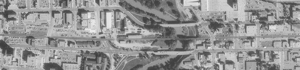
49 2010 Fargo Project Fargo, ND HIG Project Number: Client Project Number: Approximate Scale 1:6000 (1 =500 )


 www.")
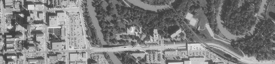
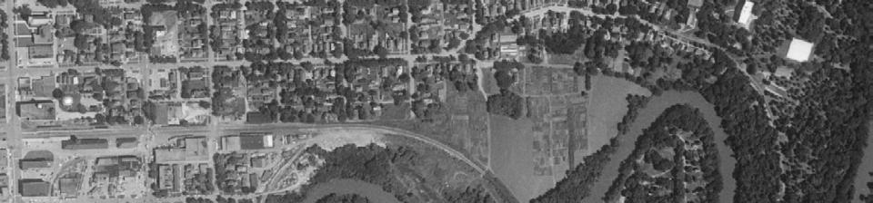
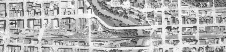
50 2005 Fargo Project Fargo, ND HIG Project Number: Client Project Number: Approximate Scale 1:6000 (1 =500 )
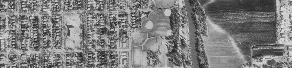
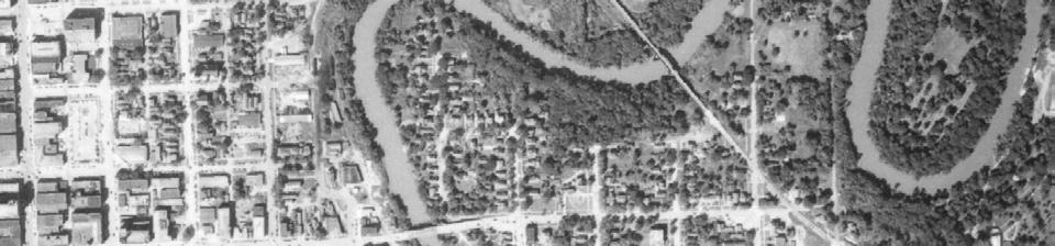
51 Fargo Project Fargo, ND 1997 HIG Project Number: Client Project Number: Approximate Scale 1:6000 (1 =500 )
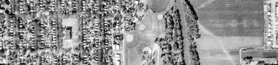
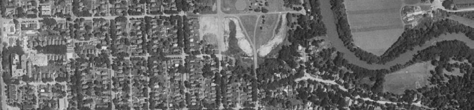
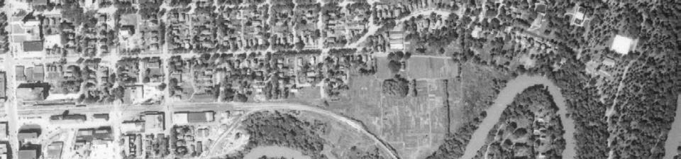
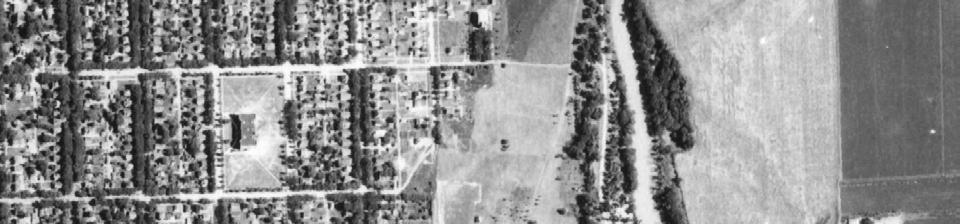
52 Fargo Project Fargo, ND 1991 HIG Project Number: Client Project Number: Approximate Scale 1:6000 (1 =500 )
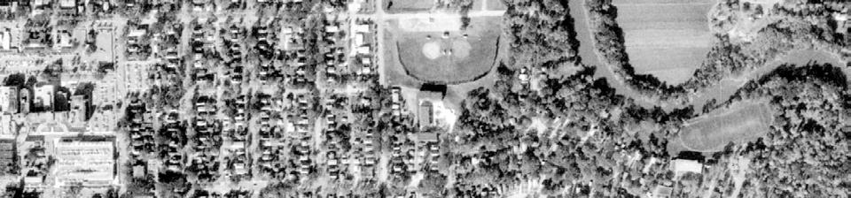

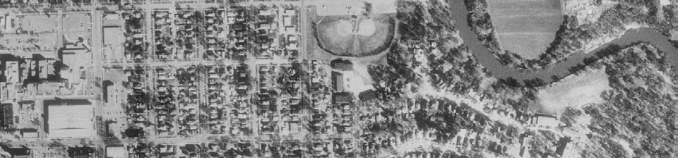
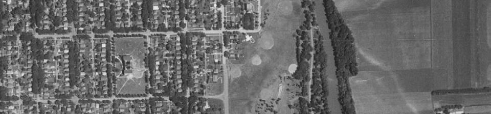
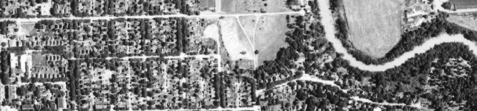
53 Fargo Project Fargo, ND 1981 HIG Project Number: Client Project Number: Approximate Scale 1:6000 (1 =500 )
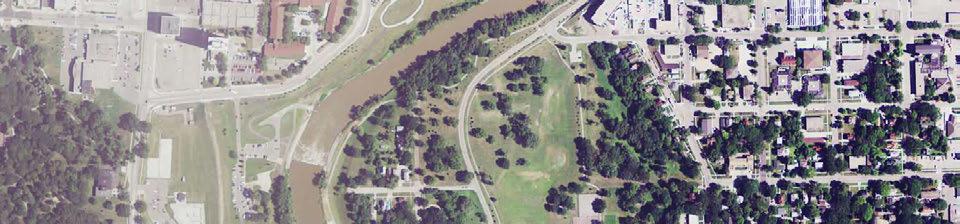
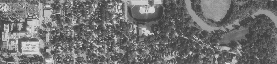
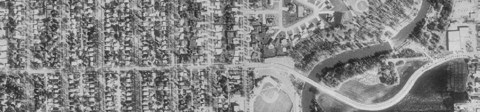
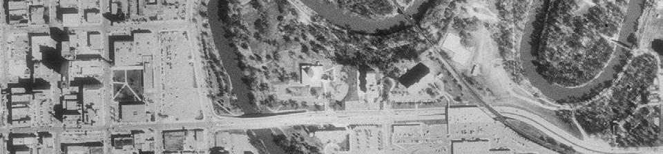
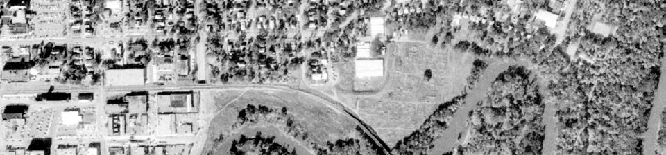
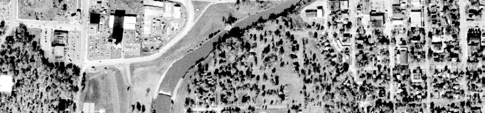
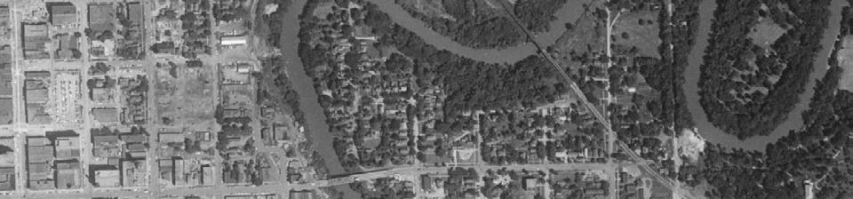
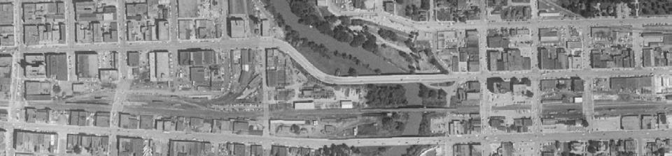
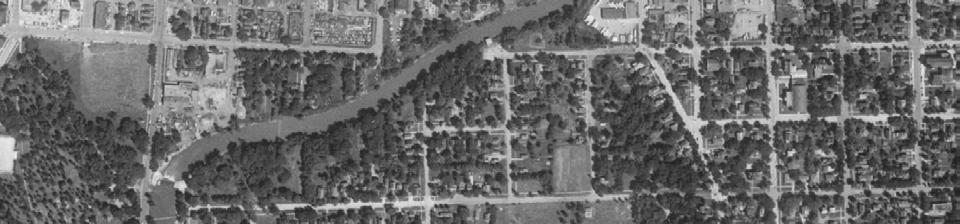
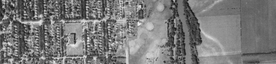
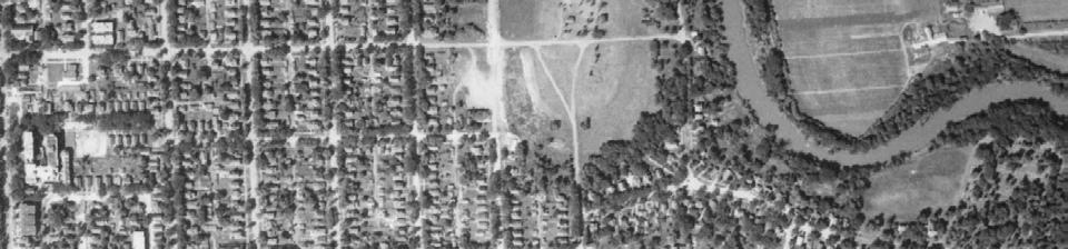
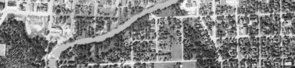
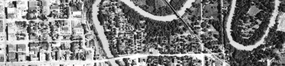
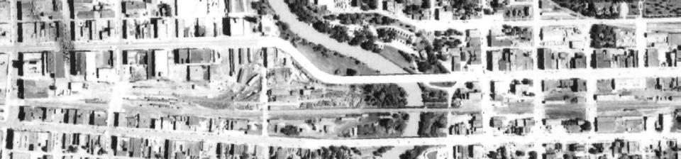
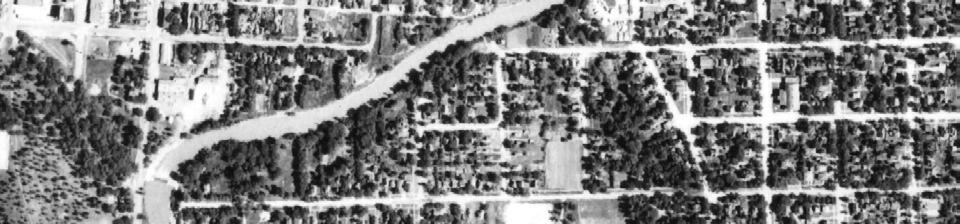
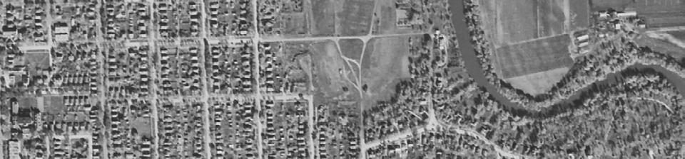
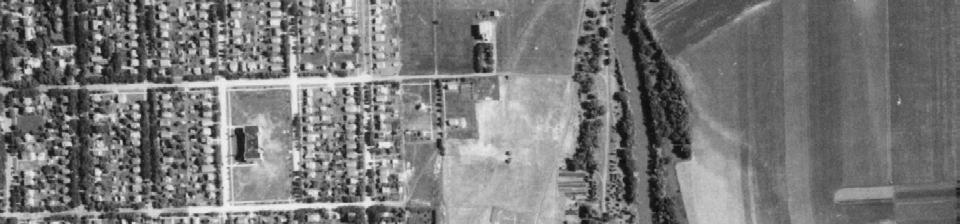
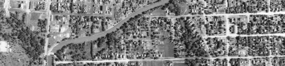
54 Fargo Project Fargo, ND 1976 HIG Project Number: Client Project Number: Approximate Scale 1:6000 (1 =500 )
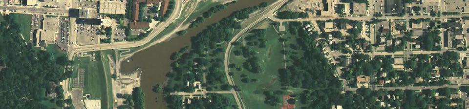
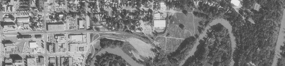
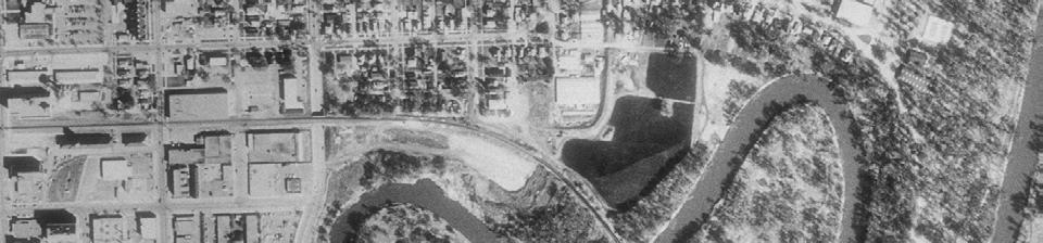
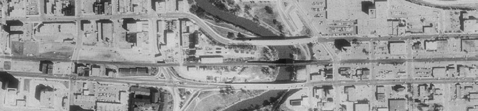
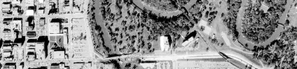
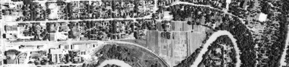
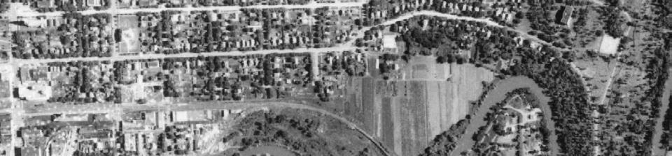
55 Fargo Project Fargo, ND 1972 HIG Project Number: Client Project Number: Approximate Scale 1:6000 (1 =500 )
 www.")
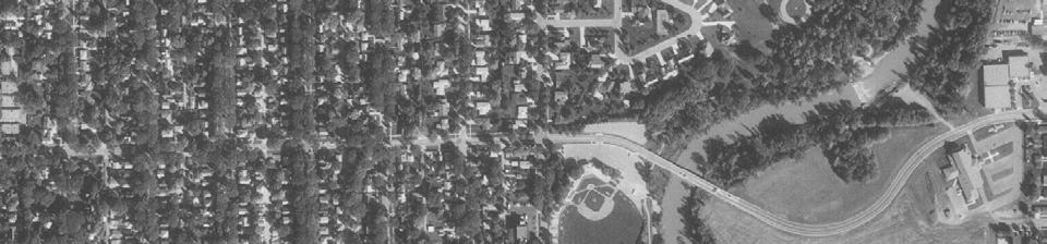
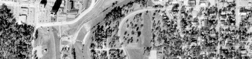
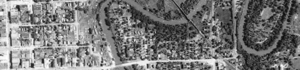
56 1965 Fargo Project Fargo, ND HIG Project Number: Client Project Number: Approximate Scale 1:6000 (1 =500 )
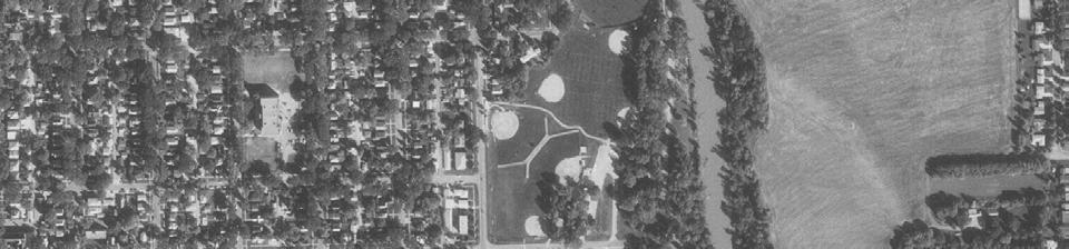
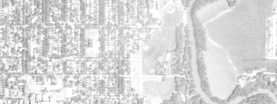
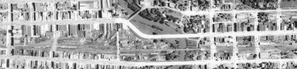
57 Fargo Project Fargo, ND 1958 HIG Project Number: Client Project Number: Approximate Scale 1:6000 (1 =500 )
58 Fargo Project Fargo, ND 1954 HIG Project Number: Client Project Number: Approximate Scale 1:6000 (1 =500 )
59 Fargo Project Fargo, ND 1948 HIG Project Number: Client Project Number: Approximate Scale 1:6000 (1 =500 )

60 Fargo Project Fargo, ND 1941 HIG Project Number: Client Project Number: Approximate Scale 1:6000 (1 =500 )

61 Fargo Project Fargo, ND 1939 HIG Project Number: Client Project Number: Approximate Scale 1:6000 (1 =500 )
62 City Hall Parking Lot Phase I Environmental Site Assessment Fargo, North Dakota July 2013 Appendix E Historical Topographic Maps
63 HIG Research Summary Site Location: FMDA Properties Fargo, ND HIG Project #: Research Summary Completed: 5/2/2013 Conducted For: HDR, Inc. 701 Xenia Avenue S., Suite 600 Golden Valley, MN This Research Summary identifies the products and services ordered from Historical Information Gatherers, Inc. (HIG) for the above referenced site location. Topographic Maps USGS Topographic Maps published in the years listed below were provided for the site location. Title blocks on each page list the map title, year and scale of the publication. 1959, 1971, 1976, 1993 Disclaimer & Waiver of Liability This Research Summary and the related documents and images provided by Historical Information Gatherers (hereafter referred to as the Site Specific HIG Data ) contain information obtained from a variety of public and private sources. Additional information for the site and surrounding properties may exist. Accordingly, there can be no guaranty that the information provided is complete for its intended purpose. No warranty expressed or implied, is made whatsoever in connection with the Site Specific HIG Data. Historical Information Gatherers specifically disclaims the making of any such warranties, including without limitation, merchantability or fitness for a particular purpose. Historical Information Gatherers, its officers, employees and independent contractors cannot be held liable to anyone for any loss or damage, whether arising out of errors or omissions, negligence, accident or any other cause, resulting directly or indirectly from any information provided or any information not provided in the Site Specific HIG Data. Any liability on the part of Historical Information Gatherers is strictly limited to a refund equal to the amount paid for the Site Specific HIG Data. HIG Copyright Notice Copyright 2013 by Historical Information Gatherers, Inc. All rights reserved. The person or entity that ordered and paid for the Site Specific HIG Data is granted a limited license to reproduce the Site Specific HIG Data solely for purposes of providing supporting documentation for reports produced for the site location which is noted on page one of this Research Summary. Any other reproduction of the Site Specific HIG Data in any media or format, in whole or in part, is prohibited without prior written permission from Historical Information Gatherers. Licensing Agreement The licensing agreement between Historical Information Gatherers and infogroup provides that Historical Information Gatherers may create photocopies or reproductions of portions of Polk City Directories, Hill-Donnelley Criss-Cross Directories and other directories under infogroup copyright. The licensing agreement also permits the person or entity that ordered and paid for the Site Specific HIG Data to include photocopies or reproductions of portions of Polk City Directories, Hill-Donnelley Criss-Cross Directories and other directories under infogroup copyright as supporting documents for reports produced for the site which is the subject of the Site Specific HIG Data. Historical Information Gatherers Page 1 of 1

64 1993 Fargo North, North Dakota Quadrangle USGS 7.5 Minute Topographic Map Miles 0 1,250 2,500 5,000Feet Km
65 1976 Fargo North, North Dakota Quadrangle USGS 7.5 Minute Topographic Map Miles 0 1,250 2,500 5,000Feet Km

66 1971 Fargo North, North Dakota Quadrangle USGS 7.5 Minute Topographic Map Miles 0 1,250 2,500 5,000Feet Km

67 1959 Fargo North, North Dakota Quadrangle USGS 7.5 Minute Topographic Map Miles 0 1,250 2,500 5,000Feet Km
68 City Hall Parking Lot Phase I Environmental Site Assessment Fargo, North Dakota July 2013 Appendix F Environmental Lien Search Results
69 Order Number Effective Date 5/3/2013 Last name CITY OF FARGO First name County CASS Street address 200 2ND AVE City FARGO State ND Mailing address 200 3RD ST N, FARGO ND Parcel Number Alternate parcel number Legal Desc. N D URBAN RENEWAL #1 ALL BLK 6 LESS TRI PC DED FOR BRIDGE R/W Federal, state, and local environmental records have been researched, resulting in the following list of recorded environmental liens and AUL's (activity and usage limitations) for the subject property having been found: ENVIRONMENTAL LIENS, IC s, LUC s, AUL s, & DEUR s 1 NONE FOUND WITH UNITED STATES EPA 2 NONE FOUND WITH NORTH DAKOTA DEPARTMENT OF ENVIRONMENTAL HEALTH 3 NONE FOUND IN THE CASS COUNTY OFFICIAL LAND RECORDS 4 JUDGMENTS, LIENS 1 NONE FOUND WITH NORTH DAKOTA DEPARTMENT OF ENVIRONMENTAL HEALTH 2 NO PENDING ENFORCEMENT ACTION LOCATED 3 4 OTHER INFORMATION: This search is subject to the terms and conditions at TitleSearch.com.
70 City Hall Parking Lot Phase I Environmental Site Assessment Fargo, North Dakota July 2013 Appendix G Previous Investigation Reports
71 AWD Flows Through Project HTRW Assessments and Cost Estimates for Potential Buyout Properties in Fargo, North Dakota 1 P age May 2012
72 Table of Contents 1.0 Introduction HTRW Evaluation Background Review Study Area Reconnaissance HTRW Evaluation Cost Estimations Methodology Results Limitations Conclusions... 5 Appendices Appendix A EDR Report Appendix B Historical Aerial Photographs Appendix C City Directory Appendix D Fire Insurance Maps Appendix E Property Tax Records Appendix F HTRW Assessment Data Sheets Appendix G Cost Estimation Tables 1 P age
73 1.0 Introduction HDR Engineering, Inc. (HDR) conducted a preliminary Hazardous, Toxic, and Radioactive Waste (HTRW) evaluation of proposed properties that may be acquired by the Flood Diversion Authority as a part of the AWD Project (Project) to increase flows during flooding in the Red River through the towns of Fargo, North Dakota and Moorhead, Minnesota. This report focuses on properties identified in Fargo, North Dakota that would be impacted based on modeled flood stage levels. The objective of this report was to develop planning level cost estimates associated with HTRW should future flood impacted properties be purchased and demolished as a part of the Project. Estimated costs to address HTRW related issues for the Project were evaluated in two parts: 1) Evaluation of identified properties within the study area (see Figure 1) for the likely presence of HTRW and to assign relative risk levels 2) Development of planning level clean up and/or abatement costs. The evaluation involved a review of historical sources such as: aerial photographs, city directories, fire insurance maps, governmental database records, and property tax records. A limited site reconnaissance was also conducted on February 28, Following the HTRW evaluation, estimated costs were developed by factoring in risk levels, property size, building size, and generalized costs for clean up and/or abatement. 2.0 HTRW Evaluation The HTRW evaluation focused on gathering background data for the study area identified in Figure 1. This study area was evaluated during the background review and the site reconnaissance. For the purpose of this report, only the following properties will be discussed and evaluated, since they have been identified as potential buyout properties required for the Project. Property Name Oak Grove Residential Homes Oak Grove Lutheran Table 1. Potential Buyout Properties Address(es) Multiple (North Ter N., South Ter N., Short St N.) 103 North Ter N., 124 North Ter N., and 88 South Ter N. Fargo Public Schools rd St N., rd St N. Commercial Office Building th Ave N. Howard Johnson rd Ave N. City Hall Parking Lot nd St N. Mid America Steel Park East Apartments 1 2 nd St S. 92 Northern Pacific Ave N, 96 Northern Pacific Ave N, and 101 Northern Pacific Ave N 1 P age
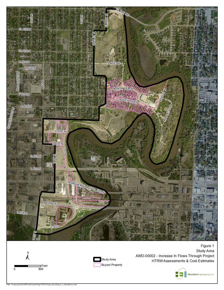
74 2 P age
75 2.1 Background Review HDR authorized Environmental Data Resources Inc. (EDR) to conduct a governmental database search of the study area. The database search identified listings within the study area and within a 1 mile buffer that were listed in federal, state, local, and tribal records. The search identified listings associated with two sites identified in Table 1. Details of these listings for these two sites are described further in the HTRW Assessment Summary Data Sheets. A copy of the EDR report is located in Appendix A. Historical Information Gatherers (HIG) provided HDR with copies of historical aerial photographs, city directories, and fire insurance maps. These sources were valuable in assessing former land use in the study area back to the late 1800s. The coverage of these historical sources in the study area was as follows: Table 2. Historical Source Coverage Historical Source Coverage Periods Aerial Photographs 1939, 1941, 1948, 1954, 1958, 1965, 1972, 1976, 1981, 1991, 1997, 2005, and 2010 City Directories 1928, 1934, 1940, 1945, 1951, 1956, 1961, 1966, 1971, 1976, 1981, 1986, 1991, 1996, 2001, 2006, and 2009 Fire Insurance Maps 1880s, 1890s, 1900s, 1910s, 1920s, and 1950s Copies of these sources are located in Appendix B (Historical Aerial Photographs), Appendix C (City Directories), and Appendix D (Fire Insurance Maps). Detailed discussion on these sources is provided in the HTRW Assessment Summary Data Sheets. Property tax records were also collected from the City of Fargo website ( ) for each of the properties listed in Table 1. Several representative properties were reviewed for the Oak Grove residential homes. Relevant information such as number of structures, age, square footage, and lot size were provided. Copies of these records are provided in Appendix E (Property Tax Records). 2.2 Study Area Reconnaissance On February 28, 2012, HDR personnel conducted a reconnaissance of the study area, focusing particularly on properties that had been identified for potential buyout. Site access to private residences and businesses was not provided for the review. Interiors of buildings were also not reviewed during the site reconnaissance. Observations of the study area were conducted from public roadways, public land, and lots accessible to the public. The study area consisted of a mix of residential, commercial, and industrial land uses. Residential properties were mainly located near the north end of the study area in the Oak Grove neighborhood. Commercial properties in the study area consisted of warehouses, laundering services, 1 P age
76 motels, gas stations, office buildings, and retail stores. Industrial properties were limited to the Mid America Steel property, where public site access was prohibited. The location of the property at an elevated level to some of the surrounding streets and a perimeter fence limited the field review of the property. 2.3 HTRW Evaluation The data collected during the background review and site reconnaissance was compiled and summarized in the HTRW Assessment Summary Data Sheets for each of the sites listed in Table 1. The HTRW Assessment Summary Data Sheets are provided in Appendix F. The following table summarizes the findings associated with each of the buyout properties. Details regarding the determination for these ratings are discussed in the HTRW Assessment Summary Data Sheets. 2 P age Table 3. Identified HTRW and Associated Risk Levels HTRW Property Asbestos Lead Other Oak Grove Lutheran Low, due to recent renovations Low, due to recent renovations None Residential Properties Low Med Medium None Fargo Public Schools Low Med Low Med Medium. Potential soil contamination if soil disturbance will occur. Contaminants of Concern (COCs): PAHs and metals from former coal storage. Commercial Office Building Low Med Low Low Med. Potential for minor soil contamination associated with former use as RR siding. COCs: petroleum products, metals, creosote, PAHs. Howard Johnson Low Med Low None City Hall Parking Lot N/A N/A Medium. Adjacent Tannery and foundry in early 1900s. Possible chromium, other metals, and VOCs present. Case Plaza Low, due to recent renovations Low, due to recent renovations Medium. Potential soil contamination if the lot is disturbed. COCs: PAHs, PCP, and metals. Mid America Steel Medium Medium Med High. Historic use as a foundry and steel plant dating back to the early 1900s. COCs:
77 Park East Apartments Low Low None arsenic, lead, PAHs, VOCs. Based on the age of development in this area, with most structures built during the early to mid 1900s, all the identified sites with structures on them had a potential for containing lead and asbestos containing building material. 3.0 Cost Estimations Costs to address HTRW related clean up and/or abatement activities were estimated by combining the results of the assessment with other assumed costs further described in this section. 3.1 Methodology Since the review of each property was limited (specifically the interior of structures were not observed) and personal interviews were prohibited, a risk level was assigned to each property based only on information that was gathered in historical documents and during the site reconnaissance. The risk ratings were broken into low, medium, and high. HTRW issues were also categorized as a soil, asbestos, or lead cleanup. Multiple HTRW issues were typically identified at each site. The following table provides a breakdown of values assigned to each rating and HTRW category. Table 4. Risk Ratings Risk Ratings Soil Volume based on % of site (to 0.5') Lead Abatement based on % of Structure Asbestos Abatement based on % of structure Low 5% 1% 10% Moderate 25% 10% 30% High 50% 20% 50% Since actual bulk surveys and subsurface site investigations were not performed to more accurately identify HTRW issues for each site, the estimated cost was normalized for each property by reflecting clean up cost as a percentage of the lot size or structure(s). The following formula was used to calculate total costs for each property. 3 P age C = Ad + Ch+ ((R S x A L ) x C S ) + ((R L x A B ) x C L ) + ((R A x A B ) x C A )+U In this formula C represents the total HTRW clean up cost for a particular property; Ad represents administrative costs; Ch represents characterizing costs (Phase I ESA, Phase II ESA, and Bulk Survey); R S, R L, and R A are the risk percentages (Table 4) that were assigned to each property (Table 3); A L represents
78 the area of the property lot; A B represents the area or square footage of a structure(s); C S, C L, and C A represent clean up costs as a function of volume (for soil) or area (for lead and asbestos), and U represents the cost to remove and dispose of an underground storage tank. 3.2 Results The following table summarizes the estimated costs for each property based on the formula shown in Section 3.1. Table 5. Estimated HTRW Costs Property HTRW Clean Up Cost % of Total Cost Case Plaza $57, % Fargo Public Schools $92, % Howard Johnson $88, % Mid America Steel $440, % Oak Grove $87, % Park East Apartments $108, % Residential Properties* $6, % Commercial Office Building $22, % City Hall Parking Lot $69, % Total HTRW Cost Estimation** $973,000 * assumes 5 residential properties will be acquired ** final value rounded to the nearest thousand The data used to develop these costs are described in detailed tables located in Appendix G. 3.3 Limitations The HTRW cost estimates provided for the Project were prepared based on a planning level assessment, where the actual presence of HTRW has not been confirmed. A full ASTM Phase I Environmental Site Assessment (ESA) was not performed. Phase I ESAs, Phase II ESAs, and bulk surveys are needed to refine associated HTRW costs. These assessments and surveys would quantitatively identify contaminants of concern (COC) and areas of contamination that would require clean up. The HTRW costs were also developed assuming flat rates for oversight, removal, and disposal for lead and asbestos as a function of square footage. In actuality, these costs would vary based on materials present at each structure and whether not those materials would require abatement before demolition. Asbestos abatement may also involve pipe insulation at commercial and industrial sites. This would not fall under the calculations using square footage and may increase abatement costs. Lead abatement also varies based on the need for stabilization or full removal prior to demolition. All these unknown 4 P age
79 factors would be addressed with a bulk survey where the properties would be evaluated by a certified inspector and materials tested by a certified laboratory. The bulk survey is a requirement by the North Dakota Department of Health prior to demolition. The goal of this evaluation was to provide a general estimate of potential HTRW costs. This will be added to other Project related estimates to determine a total cost to implement the Project. These costs may not reflect actual costs once the Project is implemented and characterization of the properties are conducted. Groundwater related impacts were not included in the HTRW cost estimates. It is assumed that dewatering is not required as a part of the demolition of the properties. If groundwater contamination is present, the costs associated with monitoring and remediation is highly dependent on contaminant concentrations present. This information would not be available until after the properties are characterized. 4.0 Conclusions All the properties identified for acquisition have the potential to require clean up or abatement if the Project is implemented. The cost estimates developed for addressing HTRW issues was hypothesized based on available information at this point in the Project planning. Actual clean up costs may vary significantly if the assumptions used in developing the costs change substantially following further characterization. 5 P age
80 Appendix A EDR Report Provided in Enclosed CD
81 Appendix B Historical Aerial Photographs Provided in Enclosed CD
82 Appendix C City Directories Provided in Enclosed CD
83 Appendix D Fire Insurance Maps Provided in Enclosed CD
84 Appendix E Property Tax Records Provided in Enclosed CD
85 Appendix F HTRW Assessment Data Sheets Provided in Enclosed CD
86 Appendix G Cost Estimation Tables Provided in Enclosed CD
87 City Hall Parking Lot Phase I Environmental Site Assessment Fargo, North Dakota July 2013 Appendix H Site Photographs
88 Emergency back-up generator located along the west side of the parking lot. East parking lot entrance located off Second Street N.
89 Electrical transformer located in the northwest corner of the parking lot. City of Fargo reserved spaces with electical outlets located along the north side.
90 Stormwater lift station located in the northeast corner of the parking lot. View of the parking lot from the sidewalk along Second Street N.
91 Garden area with sprinkler system located in the southeast corner of the parking lot. View of the east side of the sanitary sewer lift station.
92 View of transformers and meters located along the north side of the sanitary sewer lift station. View looking north towards the west entrance of the parking lot off of Third Street N.
93 View of the front of the stormwater lift station. Fill pipes located along the west side of the stormwater lift station.
94 Electrical meter located along the north side of the parking lot.

95 Panoramic view looking south with the City Hall Parking lot to the west and the Red River to the east.
Environmental Audit Standards
 Environmental Audit Standards Lender requires an acceptable Phase I Environmental Audit Report, directed to Lender and historical in nature, which is to be prepared in accordance with the standards set
Phase I Environmental Site Assessment Update Memorandum Vacant Property 1585 Santa Clara Avenue Santa Ana, California 92507
 March 1, 2011 Mr. Vincent C. Fregoso, AICP City of Santa Ana 20 Civic Center Plaza Santa Ana, CA 92702 Re: Phase I Environmental Site Assessment Update Memorandum Vacant Property 1585 Santa Clara Avenue
ENVIRONMENTAL SITE ASSESSMENT (AAI COMPLIANT PHASE I)
") ENVIRONMENTAL SITE ASSESSMENT (AAI COMPLIANT PHASE I) IPP.MORELAND AVENUE ASSEMBLAGE 785-793 MORELAND AVENUE ATLANTA, GEORGIA, 30316 ONE GROUP PROJECT #A6092 JANUARY 28, 2008 PREPARED FOR: FAIRVIEW COMMERCIAL
ENVIRONMENTAL SITE ASSESSMENT (AAI COMPLIANT PHASE I) IPP.MORELAND AVENUE ASSEMBLAGE 785-793 MORELAND AVENUE ATLANTA, GEORGIA, 30316 ONE GROUP PROJECT #A6092 JANUARY 28, 2008 PREPARED FOR: FAIRVIEW COMMERCIAL
Hazardous Materials in Project Development Additional Guidance
 Hazardous Materials in Project Development Additional Guidance Contents:...2 AASHTO Guidance...3 USDOT Brownfields Guidance...4 ASTM Standard Practices...6 Hazardous Materials in Project Development 1
DRAFT - Subject to Change. Cathedral Building 212 North Ash Street Crookston, Minnesota. Prepared For. Project FA June 29, 2011
 DRAFT Phase I Environmental Site Assessment Cathedral Building 212 North Ash Street Crookston, Minnesota Prepared For Braun Intertec Corporation Ms. Kay Hegge Prairie Skyline Foundation 27048 310th Street
Interstate I-10/County Road 255 Madison County, Florida 32341
 Love s Truck Stop Red Onion Truck Stop Interstate I-10/County Road 255 Madison County, Florida 32341 Property Features 57.73 Acres Zoning: Mixed Use Tax ID: 261S101316002004, 261S121316002000 & 261S101316002003
PHASE I ENVIRONMENTAL SITE ASSESSMENT
 PHASE I ENVIRONMENTAL SITE ASSESSMENT ACME Gas 55 Garden Street Columbus, Ohio, 45123 Prepared for ACME Oil & Gas Ltd. Prepared by GAEA Environmental Services 87 Garden Street Whitby, Ontario L1N 9E7 November
Due Diligence & Environmental Compliance Issues for Tribal Energy Projects: Hazardous Waste
 Due Diligence & Environmental Compliance Issues for Tribal Energy Projects: Law Seminars International Seattle, WA October 23, 2007 Connie Sue Manos Martin Hazardous Waste Overview Environmental Due Diligence:
Phase I Environmental Site Assessments for Corridors
 Phase I Environmental Site Assessments for Corridors Prepared by: Kimberly Perkins and Jill Biesma 1 Environmental Advisors and Engineers 19211 W. 64 th Terrace, Shawnee, KS 66218 (913) 599-4326 Goal Of
No warranty or representation, expressed or implied, is made as to the accuracy of information contained herein, and same is submitted subject to
 No warranty or representation, expressed or implied, is made as to the accuracy of information contained herein, and same is submitted subject to errors, omissions, change of price, rental, or other conditions
BROWNFIELD CLEANUP PROGRAM (BCP) APPLICATION FORM
 APPLICATION FORM") BROWNFIELD CLEANUP PROGRAM (BCP) APPLICATION FORM PART A (note: application is separated into Parts A and B for DEC review purposes) Section I. Requestor Information - See Instructions for Further Guidance
BROWNFIELD CLEANUP PROGRAM (BCP) APPLICATION FORM PART A (note: application is separated into Parts A and B for DEC review purposes) Section I. Requestor Information - See Instructions for Further Guidance
Voluntary standard; accepted by USEPA to comply with AAI rule. 2. Regulatory/Developmental History
 This table summarizes some of the primary differences between the New Jersey Department of Environmental Protection (NJDEP) Preliminary Assessment Report (PAR), pursuant to the April 2013 NJDEP Site Remediation
Seller Property Disclosure (Commercial)
") 14114035 0 true 0 AR 60024816 test tbd4 036012-800153-54774 Taleda Mckee JC TH Page 1 of 7 TO BE COMPLETED BY SELLER: (Please Print) Date: 08/28/ Seller(s): River City Flooring, Inc. Seller is is not occupying
14114035 0 true 0 AR 60024816 test tbd4 036012-800153-54774 Taleda Mckee JC TH Page 1 of 7 TO BE COMPLETED BY SELLER: (Please Print) Date: 08/28/ Seller(s): River City Flooring, Inc. Seller is is not occupying
BROWNFIELDS Connecticut All Grantee Meeting July Getting the most out of All Appropriate Inquiries (AAI)
") BROWNFIELDS Connecticut All Grantee Meeting July 11 2012 Getting the most out of All Appropriate Inquiries (AAI) 1 AAI in Perspective All Appropriate Inquiries often is a critical step in a continuum of
BROWNFIELDS Connecticut All Grantee Meeting July 11 2012 Getting the most out of All Appropriate Inquiries (AAI) 1 AAI in Perspective All Appropriate Inquiries often is a critical step in a continuum of
October 29, 2013 Florida Brownfields Association Conference, Orlando
 Site Inventories October 29, 2013 Florida Brownfields Association Conference, Orlando Andrew M. Lawn, M.S., P.G. Principal Hydrogeologist Holden Heights Areas HSW & Orange County Environmental Protection
Environmental. Due Diligence 9 Steps Companies Should Take to Effectively Manage. Environmental. Risks in Commercial Real Estate Deals
 ESIS Health, Safety, and Advisory Series Due Diligence 9 Steps Companies Should Take to Effectively Manage Risks in Commercial Real Estate Deals By Bill Felix, Due Diligence Practice Leader, ESIS Health,
PHASE I ENVIRONMENTAL SITE ASSESSMENT REPORT 3.3-ACRE ECKENRODE PROPERTY WARWICK TOWNSHIP, TUSCARAWAS COUNTY, OHIO. Prepared for: OHIOLAND, LLC
 PHASE I ENVIRONMENTAL SITE ASSESSMENT REPORT 3.3-ACRE ECKENRODE PROPERTY WARWICK TOWNSHIP, TUSCARAWAS COUNTY, OHIO Prepared for: OHIOLAND, LLC Prepared by: CIVIL & ENVIRONMENTAL CONSULTANTS, INC. COLUMBUS,
STANDARD FORM Proposal to Purchase and Agreement for Transfer of Ownership of Distribution Systems Form No
 PROPOSAL TO PURCHASE AND AGREEMENT FOR TRANSFER OF OWNERSHIP OF DISTRIBUTION SYSTEMS This Proposal to Purchase ( Proposal ) and Agreement for Transfer of Ownership of Distribution Systems ( Agreement )
Environmental Due Diligence
 2017 NJ Land Conservation Rally Environmental Due Diligence Stephen Kehayes Michelle Slosberg Peter Sorge, LSRP 1. Introduction 2. Due Diligence Process 3. Potential Problems 4. Investigation 5. Regulatory
Phase I ESAs and the USEPA's All Appropriate Inquiry Final Rule
 Page 1 of 8 Phase I ESAs and the USEPA's All Appropriate Inquiry Final Rule An Electronic Newsletter of EEA's Environmental Consulting Activities Spring 2007 EEA, Inc. 55 Hilton Avenue, Garden City, New
Change is in the air with regard. feature
 em feature Amy L. Edwards is a partner in the law firm of Holland & Knight LLP, Washington, DC, where she co-chairs the firm s national environmental team. Sarah C. Smith is an associate at Holland & Knight.
FOR LEASE - Divisible 3,200sf to 11,500sf PRIME WAREHOUSE IN MOUNT VERNON NY!
 OFFERING MEMORANDUM 17-21 Bertel Ave. Mount Vernon, NY 10550 FOR LEASE - Divisible 3,200sf to 11,500sf PRIME WAREHOUSE IN MOUNT VERNON NY! FOR LEASE - Divisible 3,200sf to 11,500sf CONTENTS 01 Property
The University of Texas System Systemwide Policy. Policy: UTS Title. Environmental Review for Acquisition of Real Property. 2.
 1. Title 2. Policy Environmental Review for Acquisition of Real Property Sec. 1 Sec. 2 Policy Statement. It is the policy of The University of Texas System to minimize its potential for exposure to claims
New Environmental Diligence Standards for All Appropriate Inquiries (AAI)
") New Environmental Diligence Standards for All Appropriate Inquiries (AAI) (a live interactive 90-Minute Teleconference Program) Peter Murphy 1050 Connecticut Ave., N.W. Washington, D.C. 20036 pmurphy@gibsondunn.com
New Environmental Diligence Standards for All Appropriate Inquiries (AAI) (a live interactive 90-Minute Teleconference Program) Peter Murphy 1050 Connecticut Ave., N.W. Washington, D.C. 20036 pmurphy@gibsondunn.com
New Phase I Requirements for Real Estate Transactions: Implications of the New All Appropriate Inquiries Rule
 New Phase I Requirements for Real Estate Transactions: Implications of the New All Appropriate Inquiries Rule Helen Currie Foster Graves, Dougherty, Hearon & Moody, P.C. 1 State Bar of Texas 28 th Annual
CITY OF VAUGHAN POLICY AND PROCEDURES FOR DEALING WITH CONTAMINATED OR POTENTIALLY CONTAMINATED SITES
 CITY OF VAUGHAN POLICY AND PROCEDURES FOR DEALING WITH CONTAMINATED OR POTENTIALLY CONTAMINATED SITES MAY 2001 This Report should be read in conjunction with the City of Vaughan BACKGROUND REPORT ON POLICY
The address of the property is:
 The address of the property is:. Fee for the inspection is $. INSPECTOR acknowledges receiving a deposit of $ from CLIENT. THIS AGREEMENT made this day of, 20, by and between (hereinafter "INSPECTOR")
PHASE I ENVIRONMENTAL SITE ASSESSMENT AGGREGATE PRODUCTION ASSOCIATES PARCEL 2623 CENTER STREET OMAHA, DOUGLAS COUNTY, NEBRASKA
 PHASE I ENVIRONMENTAL SITE ASSESSMENT AGGREGATE PRODUCTION ASSOCIATES PARCEL 2623 CENTER STREET OMAHA, DOUGLAS COUNTY, NEBRASKA Prepared for: Aggregate Production Associates, Inc. & the Omaha Brownfields
ATTACHMENT 4 CERCLA NOTICE, COVENANT, AND ACCESS PROVISIONS AND OTHER DEED PROVISIONS
 ATTACHMENT 4 CERCLA NOTICE, COVENANT, AND ACCESS PROVISIONS AND OTHER DEED PROVISIONS CERCLA NOTICE, COVENANT, AND ACCESS PROVISIONS AND OTHER DEED PROVISIONS The following CERCLA Notice, Covenant, and
Truck Repair Facility
 Truck Repair Facility OFFERING MEMORANDUM 18244 Valley Blvd Bloomington, CA 92316 Truck Repair Facility CONTENTS 01 Executive Summary Executive Summary 5 Location Summary 6 Demographics 7 Demographic Charts
STATE OF SOUTH CAROLINA RESIDENTIAL PROPERTY CONDITION DISCLOSURE STATEMENT
 STATE OF SOUTH CAROLINA RESIDENTIAL PROPERTY CONDITION DISCLOSURE STATEMENT The South Carolina Code of Laws (Title 27, Chapter 50, Article l) requires that an owner of residential real property (single
STATE OF SOUTH CAROLINA RESIDENTIAL PROPERTY CONDITION DISCLOSURE STATEMENT
 STATE OF SOUTH CAROLINA RESIDENTIAL PROPERTY CONDITION DISCLOSURE STATEMENT The South Carolina Code of Laws (Title 27, Chapter 50, Article 1) requires that an owner of residential real property (single
New Home Tax Disclosure Report
 New Home Tax Disclosure Report This report satisfies the seller s obligation, pursuant to Civil Code Section 1102.6b, to disclose all special tax and/or assessment districts affecting the subject property
Development Related Fee Schedule Effective May 1, Plan Reviews. Remodeling, Alterations, Additions Residential and Commercial
 Plan Reviews Plan Review Payable at the time a permit application is submitted. Per hour fee for reviews exceeding standard review times payable prior to the issuance of a permit. Remodeling, Alterations,
Development Related Fee Schedule Effective May 1, Plan Reviews. Remodeling, Alterations, Additions Residential and Commercial
 Plan Reviews Plan Review Payable at the time a permit application is submitted. Per hour fee for reviews exceeding the standard review times are payable prior to the issuance of a permit. Remodeling, Alterations,
FOR LEASE - $9.50 psf Gross
 FOR LEASE - $9.50 psf Gross OFFERING MEMORANDUM... 315 E. THIRD ST., MOUNT VERNON, NY 10553 22,250 SF OF PRIME WAREHOUSE SPACE... FOR LEASE - $9.50 psf Gross CONTENTS 01 Property Description Property Features
ADMINISTRATIVE GUIDANCE
 11 ADMINISTRATIVE GUIDANCE ON CONTAMINATED SITES Effective date: April 1, 2013 Version 1.1 May 2013 Expectations and Requirements for Contaminant Migration Introduction This guidance focusses on the ministry
A.3. ARTICLE 7 PLAN REQUIREMENTS FOR MINOR SUBDIVISION AND/OR LAND DEVELOPMENT
 700. 701.A.3. ARTICLE 7 PLAN REQUIREMENTS FOR MINOR SUBDIVISION AND/OR LAND DEVELOPMENT SECTION 700 PURPOSE The purpose of this Article is to set forth a streamlined set of Plan Requirements for minor
Due Diligence for Property Acquisitions
 Due Diligence for Property Acquisitions Presenters: Mary Guinee Principal, Due Diligence Services Ray Sinagra, AIA Sr. Project Manager, Property Condition Assessment Services April 28, 2009 Conference
RIGHT OF WAY DATA SHEET (Form #)
") STATE OF CALIFORNIA DEPARTMENT OF TRANSPORTATION RIGHT OF WAY DATA SHEET (Form #) Date 07/16/2015 Dist 03 Co PLA Rte 80 P/M 0.1/2.2 and 4.1/6.0 EA 03-3F230 EXHIBIT 4-EX-1 (REV 3/2004) Page 1 of 6 Project
STATE OF CALIFORNIA DEPARTMENT OF TRANSPORTATION RIGHT OF WAY DATA SHEET (Form #) Date 07/16/2015 Dist 03 Co PLA Rte 80 P/M 0.1/2.2 and 4.1/6.0 EA 03-3F230 EXHIBIT 4-EX-1 (REV 3/2004) Page 1 of 6 Project
Lotsearch Pty Ltd ABN
 E M PL EPA Register & Data Search Lotsearch Reference: Client Id: Report Date: 16:12:29 Address: Lot & Plans: Lot 130, DP1100149 SA Disclaimer: The purpose of this report is to provide an overview of some
SELLER S PROPERTY DISCLOSURE STATEMENT
 INSTRUCTIONS TO THE SELLER 1 2 3 4 5 6 7 8 9 10 11 12 13 14 15 16 17 18 19 20 21 22 23 24 25 Please complete the following form. Do not leave any spaces blank. Please refer to the line number(s) of the
PHASE I ENVIRONMENTAL SITE ASSESSMENT 1724 VINTON STREET & 2702 SOUTH 18 TH STREET OMAHA, DOUGLAS COUNTY, NEBRASKA
 PHASE I ENVIRONMENTAL SITE ASSESSMENT 1724 VINTON STREET & 2702 SOUTH 18 TH STREET OMAHA, DOUGLAS COUNTY, NEBRASKA Prepared for: The Estate of George W. Murray & the Omaha Brownfields Coalition Benesch
Development Related Fee Schedule Effective May 1, Plan Reviews. Remodeling, Alterations, Additions Residential and Commercial
 Plan Reviews Plan Review Payable at the time a permit application is submitted. Per hour fee for reviews exceeding the standard review times are payable prior to the issuance of a permit. Remodeling, Alterations,
47.9 acres + Amenities Lower Rocky River Road, Cabarrus County NC
 47.9 acres + Amenities Lower Rocky River Road, Cabarrus County NC INFORMATION PACKAGE Exclusive Listing Agency Franklin Buddy Hege, CCIM Gibson Smith Realty Co. 1100 Kenilworth Ave., Suite 200 Charlotte,
OREGON SELLER S PROPERTY DISCLOSURE STATEMENT
 OREGON SELLER S PROPERTY DISCLOSURE STATEMENT INSTRUCTIONS TO THE SELLER Please complete the following form. Do not leave any spaces blank. Please refer to the line number(s) of the question(s) when you
Casa Dulce MHP E Lee St, Tucson, AZ Robert Grant. Pete Peterson. KW Commercial Broker (520)
") Casa Dulce MHP 4240 E Lee St, 43 Unit Park, Well Maintained!! 2013 NOI $102,085.19 based on Actual P&Ls. Electric, water, sewer, garbage billed back to tenants! Individually metered for all utilities 8.8%
Casa Dulce MHP 4240 E Lee St, 43 Unit Park, Well Maintained!! 2013 NOI $102,085.19 based on Actual P&Ls. Electric, water, sewer, garbage billed back to tenants! Individually metered for all utilities 8.8%
USEPA Brownfield Assessment Grant Application for Financial Assistance
 The Port of Greater Cincinnati Development Authority (Port Authority) is accepting applications for funding under its United States Environmental Protection Agency (USEPA) Brownfield Assessment Grant.
ENVIRONMENTAL DISCLOSURE FOR TRANSFER OF REAL PROPERTY (IC ) State Form (R / 1-07) Indiana Department of Environmental Management
 State Form (R / 1-07) Indiana Department of Environmental Management") ENVIRONMENTAL DISCLOSURE FOR TRANSFER OF REAL PROPERTY (IC 13-25-3-7.5) State Form 52653 (R / 1-07) Indiana Department of Environmental Management A WARNING TO THE PARTIES TO A TRANSFER OF PROPERTY: The
ENVIRONMENTAL DISCLOSURE FOR TRANSFER OF REAL PROPERTY (IC 13-25-3-7.5) State Form 52653 (R / 1-07) Indiana Department of Environmental Management A WARNING TO THE PARTIES TO A TRANSFER OF PROPERTY: The
Seller: Pipefitters Local 211 Joint Educational Trust Houston Area Pipefitters Training Program/Apprentice School Address: 2507 Galveston Road
 TEXAS ASSOCIATION OF REALTORS COMMERCIAL REAL ESTATE LISTING AGREEMENT EXCLUSIVE RIGHT TO SELL USE OF THIS FORM BY PERSONS WHO ARE NOT MEMBERS OF THE TEXAS ASSOCIATION OF REALTORS IS NOT AUTHORIZED Texas
PHASE I ENVIRONMENTAL ENGINEERING PHASE I REPORT 3264 PREPARED FOR: Mark Hopkins. Liberty Real Estate, LLC. 741 North State Road.
 PHASE I ENVIRONMENTAL ENGINEERING PHASE I REPORT 3264 PREPARED FOR: Mark Hopkins Liberty Real Estate, LLC 741 North State Road Salem, Utah 84653 May 25, 2012 SITE LOCATION Hawthorn Mobile Home Park 10682
ENVIRONMENTAL DUE DILIGENCE
 ENVIRONMENTAL DUE DILIGENCE Developing Solar on Landfills & Brownfields June 12-13, 2017 Chicago, Illinois Matthew E. Cohn Greensfelder Hemker & Gale, P.C. 200 West Madison Street Suite 3300 Chicago, Illinois
Phase I Environmental Site Assessment Phase I Environmental Site Assessment. Siena Lakes Site Naples, Collier County, Florida
 `` Phase I Environmental Site Assessment Phase I Environmental Site Assessment Siena Lakes Site Naples, Collier County, Florida Parcel ID Nos. 00235960009, 00236000007, 00235560001, 855 NW State 00235520009
FOR SALE 92 Acres Cultivated and Pasture Land Chilton, Falls County, TX 76632
 Cultivated and Pasture Land Chilton, Falls County, TX 76632 $228,700 For a virtual tour and investment offering go to: www.texasfarmandranchrealty.com/sales.htm Property Highlights Acres 92.39 acres MOL
FOR SALE OR LEASE - Walk to Train 8,500 SF LOFT ARTIST / WAREHOUSE IN MOUNT VERNON NY!
 OFFERING MEMORANDUM 216 Washington St. Mount Vernon, NY 10553 FOR SALE OR LEASE - Walk to Train 8,500 SF LOFT ARTIST / WAREHOUSE IN MOUNT VERNON NY! FOR SALE OR LEASE - Walk to Train CONTENTS 01 Property
DEPARTMENT OF HUMAN SERVICES, PUBLIC HEALTH DIVISION
 DEPARTMENT OF HUMAN SERVICES, PUBLIC HEALTH DIVISION 333-040-0010 DIVISION 40 DECONTAMINATION OF ILLEGAL DRUG MANUFACTURING SITES Purpose and Scope (1) Purpose: The purpose of these rules is to implement
LIMERICK TOWNSHIP 646 WEST RIDGE PIKE LIMERICK, PENNSYLVANIA 19468
 LIMERICK TOWNSHIP 646 WEST RIDGE PIKE LIMERICK, PENNSYLVANIA 19468 ADMINISTRATION OFFICES (610) 495 6432 FAX (610) 495 0353 FAX (610) 495 0952 POLICE DEPARTMENT (610) 495 7909 FAX (610) 495 5702 FEE SCHEDULE
PHASE I ENVIRONMENTAL SITE ASSESSMENT 904, 911 & 1007 South 20 th Street OMAHA, DOUGLAS COUNTY, NEBRASKA
 PHASE I ENVIRONMENTAL SITE ASSESSMENT 904, 911 & 1007 South 20 th Street OMAHA, DOUGLAS COUNTY, NEBRASKA Prepared for: J & C Snelling Properties LLC Benesch Project No. 00120137.00 March 2013 Prepared
ATTACHMENT A DISCLOSURES. 1. New Hampshire RSA 477:4-a -Notification required; Radon Gas and Lead Paint
 ATTACHMENT A DISCLOSURES 1. New Hampshire RSA 477:4-a -Notification required; Radon Gas and Lead Paint A. Radon: Radon, the product of decay of radioactive materials in rock, may be found in some areas
Environmental Health Technician: (303) ; Environmental Health Manager: (303) ;
 ; Environmental Health Manager: (303) ;") ON-SITE WASTEWATER TREATMENT SYSTEM PERMIT PROCESS FULL SYSTEM, UPGRADES, ALTERATIONS, REPAIRS AND VAULTS Prior to any work on an Onsite Wastewater Treatment System (OWTS), a permit needs to be obtained
ON-SITE WASTEWATER TREATMENT SYSTEM PERMIT PROCESS FULL SYSTEM, UPGRADES, ALTERATIONS, REPAIRS AND VAULTS Prior to any work on an Onsite Wastewater Treatment System (OWTS), a permit needs to be obtained
OFFERING MEMORANDUM 11,250 SF - M3 ZONING! PRIME HUNTS POINT WAREHOUSE FAILE STREET, BRONX NY
 OFFERING MEMORANDUM PRIME HUNTS POINT WAREHOUSE 11,250 SF - M3 ZONING! 433-437 FAILE STREET, BRONX NY PRIME HUNTS POINT WAREHOUSE CONTENTS 01 Property Description Property Features 5 Exclusively Marketed
LIM Application for 1/ 240 Hurstmere Road Takapuna 0622
 21 October 2015 G Bogiatto and B J Malcolm 23B Riverside Road OREWA 0931 LIM Application for 1/ 240 Hurstmere Road Takapuna 0622 This Land Information Memorandum (LIM) details information known to Council
PURCHASE AGREEMENT TOWNSHIP 1 SOUTH, RANGE 2 EAST, FAIRBANKS MERIDIAN, ALASKA
 PURCHASE AGREEMENT THIS AGREEMENT TO PURCHASE ( Agreement ) is entered into the last date signed below ( Effective Date ), by and between the UNIVERSITY OF ALASKA, a corporation created under the Constitution
Marketing Package S Main Street Concord NH
 Marketing Package Looking North Towards N Main St 32-34 S Main Street Concord NH Judy Niles-Simmons 603.657.1926 judy@nainorwoodgroup.com Chris Norwood 603.657.1928 cnorwood@nainorwoodgroup.com 116 South
WASHTENAW COUNTY BROWNFIELD REDEVELOPMENT AUTHORITY BROWNFIELD PLAN FOR: NORTH MAIN STREET, ANN ARBOR, MICHIGAN
 WASHTENAW COUNTY BROWNFIELD REDEVELOPMENT AUTHORITY BROWNFIELD PLAN FOR: 626-724 NORTH MAIN STREET, ANN ARBOR, MICHIGAN NEAR NORTH APARTMENTS LIMITED DIVIDEND HOUSING ASSOCIATION LIMITED PARTNERSHIP (LDHA
ACT 381 WORK PLAN INSTRUCTIONS July 2018 TO CONDUCT ELIGIBLE DEQ ENVIRONMENTAL AND/OR MSF NON-ENVIRONMENTAL ACTIVITIES
 ACT 381 WORK PLAN INSTRUCTIONS July 2018 TO CONDUCT ELIGIBLE DEQ ENVIRONMENTAL AND/OR MSF NON-ENVIRONMENTAL ACTIVITIES TABLE OF CONTENTS 1.0 INTRODUCTION 1.1 Proposed Redevelopment and Future Use for Each
Lawrence Township. Mercer County, New Jersey. Working with our Planning and Zoning Boards & A Guide to our Permit Process
 Lawrence Township Mercer County, New Jersey Working with our Planning and Zoning Boards & A Guide to our Permit Process www.lawrencetwp.com Revised January 2019 About This Guide This booklet was developed
FOR SALE. 137 Acres MOL Home Site Ranch Land & Recreational Property Kosse, Falls County, TX $411,000
 137 Acres MOL Home Site Ranch Land & Recreational Property $411,000 For virtual tour and investment offering go to: www.texasfarmandranchrealty.com Property Highlights Location The property is located
CASH SALE PURCHASE AGREEMENT
 CASH SALE PURCHASE AGREEMENT THIS AGREEMENT TO PURCHASE ( Agreement ) is entered into the last date signed below ( Effective Date ), by and between the UNIVERSITY OF ALASKA, a corporation created under
3111 NEW HYDE PARK RD
 3111 NEW HYDE PARK RD North Hills, NY 11040 FULLY LEASED 26,690 SF MEDICAL OFFICE BUILDING CLOSE PROXIMITY TO NORTHERN STATE PARKWAY AND LONG ISLAND EXPRESSWAY ASKING PRICE: $18,000,000 FOR FURTHER INFORMATION
Staff Report for Council Public Meeting
 Agenda Item 3.3 a Staff Report for Council Public Meeting Date of Meeting: April 11, 2018 Report Number: SRPRS.18.087 Department: Division: Subject: Planning and Regulatory Services Development Planning
ENVIRONMENTAL QUESTIONNAIRE AND DISCLOSURE STATEMENT
 ENVIRONMENTAL QUESTIONNAIRE AND DISCLOSURE STATEMENT The purpose of this questionnaire is to provide information about the past and present ownership and uses of the real property upon which lender will
FOR SALE F O R F U L L O F F E R I N G A N D C O N F I DEN T I A L I T Y A G R E E M E N T, C O N T A C T :
 FOR SALE F O R F U L L O F F E R I N G A N D C O N F I DEN T I A L I T Y A G R E E M E N T, C O N T A C T : Russell Cosby Executive Vice President +1 214 438 6172 russell.cosby@am.jll.com Paul A. Whitman
University of Alaska FINANCED SALE PURCHASE AGREEMENT
 University of Alaska FINANCED SALE PURCHASE AGREEMENT THIS AGREEMENT TO PURCHASE ( Agreement ) is entered into as of the last date signed below ( Effective Date ), by and between the UNIVERSITY OF ALASKA,
Credit Risk. 72 March 2013 The RMA Journal Copyright 2013 by RMA
 The Ch CR Credit Risk 72 March 2013 The RMA Journal Copyright 2013 by RMA ENVIRONMENTAL RISK MANAGEMENT anging Landscape of Phase I ESAs A discussion of some upcoming changes to ASTM E1527-05 and what
LEAD COMPLIANCE ADDENDUM To Purchase and Sale Contract
 LEAD COMPLIANCE ADDENDUM To Purchase and Sale Contract Published by and for the exclusive use of the Greater Rochester Association of REALTORS, Inc., the Monroe County Bar Association, and those County
PURCHASE AGREEMENT. 4. CONTINGENCIES. This Purchase Agreement is contingent upon the satisfaction of the following conditions:
 PURCHASE AGREEMENT 1. PARTIES. This purchase agreement (the Purchase Agreement ) is made this day of, 2017, by and between the County of Carver, Minnesota, a public body politic and corporate having the
Initial Subdivision Applications Shall Include the Following:
 Initial Subdivision Applications Shall Include the Following: 1) Subdivision Application Form: completely filled out (12 copies) 2) Plat: The Plat must adhere to the requirements set forth in the Town
Central Massachusetts Brownfields Forum Assessment and Redevelopment and Everything in Between Colonial Hotel Gardner, MA Tuesday, March 12,
 Central Massachusetts Brownfields Forum Assessment and Redevelopment and Everything in Between Colonial Hotel Gardner, MA 01440 Tuesday, March 12, 2013 13 parcels totaling 55 acres with frontage on Mill
Oak Grove MHP & Self Storage
 Oak Grove MHP & Self Storage 5420 Houston Rd, 31 trailer pads with trailers, 2 lot rentals, 1 Brick house and 62 Self-Storage 11% CAP Rate Based on Actuals 4.75 Acres of Land Up-side Potential SELLER FINANCING
Guide to Subdivision and Land Development
 Guide to Subdivision and Land Development Fraser Thomas Ltd......is an engineering and surveying consulting firm based in Highbrook which has provided Surveying, Engineering, Planning and Resource Management
PHASE I ENVIRONMENTAL SITE ASSESSMENT AXLES AND GEARS TRUCK PARTS WAREHOUSE 4808 SOUTH 26 TH STREET OMAHA, DOUGLAS COUNTY, NEBRASKA
 PHASE I ENVIRONMENTAL SITE ASSESSMENT AXLES AND GEARS TRUCK PARTS WAREHOUSE 4808 SOUTH 26 TH STREET OMAHA, DOUGLAS COUNTY, NEBRASKA Prepared for: Axles and Gears, Inc. & the Omaha Brownfields Coalition
Environmental Due Diligence and Risk Allocation
 Environmental Due Diligence and Risk Allocation Seth D. Jaffe, Esq. Foley Hoag LLP Boston, Massachusetts MCLE Environmental Basics September 18, 2008 Relevant To A Broad Array of Transactions Purchase/sale
Waseca County Planning and Zoning Office
 Waseca County Planning and Zoning Office 300 North State Street Waseca, Minnesota 56093 Phone: 507-835-0650 Fax: 507-837-5310 Form no. PZ 081009 Web Site: www.co.waseca.mn.us FEES: 1) CUP FEE- $400.00
PHASE I ENVIRONMENTAL SITE ASSESSMENT
 PHASE I ENVIRONMENTAL SITE ASSESSMENT ST. MALACHY PROPERTY, BROWNSBURG HENDRICKS COUNTY, INDIANA Terra Project No. 13-013 Environmental Audit Report Privileged Document PREPARED FOR: Town of Brownsburg
FINDING OF SUITABILITY TO TRANSFER NAVAL RESERVE CENTER DULUTH, MINNESOTA
 FINDING OF SUITABILITY TO TRANSFER NAVAL RESERVE CENTER DULUTH, MINNESOTA Prepared by: Department of the Navy Base Realignment and Closure Program Management Office Northeast 4911 S. Broad Street Philadelphia,
FEES AND COST DEPOSITS FOR SUBDIVISIONS, LAND DEVELOPMENTS AND DEVELOPMENT MATTERS SKETCH PLANS
 FEES AND COST DEPOSITS FOR SUBDIVISIONS, LAND DEVELOPMENTS AND DEVELOPMENT MATTERS SKETCH PLANS Filing Fee $ 200.00 SMALL SUBDIVISIONS (1-3 Lots, NO street improvements, wetlands or stormwater management
Illinois Association of REALTORS RESIDENTIAL REAL PROPERTY DISCLOSURE REPORT
 Illinois Association of REALTORS RESIDENTIAL REAL PROPERTY DISCLOSURE REPORT EQUAL HOUSING OPPORTUNITY NOTICE: THE PURPOSE OF THIS REPORT IS TO PROVIDE PROSPECTIVE BUYERS WITH INFORMATION ABOUT MATERIAL
MAJOR SUBDIVISION PRELIMINARY PLAT CHECKLIST
 TOWNSHIP OF EGG HARBOR PLANNING BOARD/ZONING BOARD OF ADJUSTMENT 3515 BARGAINTOWN ROAD EGG HARBOR TOWNSHIP, NJ 08234 MAJOR SUBDIVISION PRELIMINARY PLAT CHECKLIST The following checklist is designed to
WORK PHASE I ENVIRONMENTAL SITE ASSESSMENT
 PO Box 844523 Boston, MA 02284-4523 Tel: (781) 273-2500 www.ebiconsulting.com SENT VIA EMAIL TO: peter.krahenbuhl@simoncre.com August 4, 2015 Josh Simon 5111 N. Scottsdale Road Suite 200 Scottsdale, AZ
GUIDE TO SUBDIVISION & LAND DEVELOPMENT
 GUIDE TO SUBDIVISION & LAND DEVELOPMENT The Fraser Thomas Difference: Fraser Thomas Ltd is an engineering and surveying consulting firm based in Highbrook, and has been providing; Surveying, Engineering,
La Palma Professional Building
 La Palma Professional Building RARE PRIDE OF OWNERSHIP PROPERTY - 9,074 SF PRESENTED BY: JOHN MARTIN, CalBRE 01346629 949.724.4701 john@lee-associates.com DISCLAIMER This Executive Summary was prepared
NOTICE OF SEALED BID FOR SALE OF REAL PROPERTY
 NOTICE OF SEALED BID FOR SALE OF REAL PROPERTY The City of Red Oak, Texas (the "City") is accepting sealed bids for the purchase of the following real property (the Property ) for the purpose of residential
EDGEFRONT REALTY CORP. MANAGEMENT S DISCUSSION AND ANALYSIS For the three-month period ended March 31, 2013
 EDGEFRONT REALTY CORP. MANAGEMENT S DISCUSSION AND ANALYSIS For the three-month period ended March 31, 2013 May 30, 2013 MANAGEMENT S DISCUSSION AND ANALYSIS The following management s discussion and analysis
FOR SALE 605 Industry Ave DISTRIBUTION WAREHOUSE FACILITY Asking $395,000
 FOR SALE 605 Industry Ave DISTRIBUTION WAREHOUSE FACILITY Asking $395,000 For Additional Information and To View the Property Please Contact Sandy Hoff - Office Phone 218-722-5556 shoff@fisalter.com AREA
ASTM Phase I Changes and AAI Webinar
 New Jersey Institute of Technology (NJIT) Technical Assistance to Brownfield Communities (TAB) ASTM Phase I Changes and AAI Webinar Elizabeth Limbrick Bob Blauvelt March 13, 2014 973-642-4165 (Hotline)
Investment OR Owner User Opportunity IN THE HEART OF ARDSLEY VILLAGE - MIXED USE PROPERTY
 OFFERING MEMORANDUM 686 Saw Mill River Rd. Ardsley, NY 10502 Investment OR Owner User Opportunity IN THE HEART OF ARDSLEY VILLAGE - MIXED USE PROPERTY Investment OR Owner User Opportunity CONTENTS 01 Property
FORECLOSURE PURCHASE AND SALE AGREEMENT. This FORECLOSURE PURCHASE AND SALE AGREEMENT ( Agreement ) made
 made") FORECLOSURE PURCHASE AND SALE AGREEMENT This FORECLOSURE PURCHASE AND SALE AGREEMENT ( Agreement ) made this 14 th day of July, by and between NORTHWAY BANK, a banking institution organized and existing
FORECLOSURE PURCHASE AND SALE AGREEMENT This FORECLOSURE PURCHASE AND SALE AGREEMENT ( Agreement ) made this 14 th day of July, by and between NORTHWAY BANK, a banking institution organized and existing
El Paso County Development Review System Adopted Fee Schedule (2005)
") Special Districts Special District 5 (multiple districts for the same project is one fee) D $6,300 Special District Amendment 5 D $3,950 Master Plans Master Plan, Master Plan Amendment D $11,900 Land Use
Special Districts Special District 5 (multiple districts for the same project is one fee) D $6,300 Special District Amendment 5 D $3,950 Master Plans Master Plan, Master Plan Amendment D $11,900 Land Use
SELLER DISCLOSURE STATEMENT IMPROVED PROPERTY
 Page 1 of 6 SELLER: To be used in transfers of improved residential real property, including residential dwellings up to four units, new construction, condominiums not subject to a public offering statement,