APPENDIX G REAL ESTATE
|
|
|
- Egbert Bennett
- 5 years ago
- Views:
Transcription


1 BUBBLY CREEK, SOUTH BRANCH OF THE CHICAGO RIVER, ILLINOIS FEASIBILITY STUDY APPENDIX G REAL ESTATE DRAFT - NOT FOR DISTRIBUTION APRIL 2015
2 U.S. Army Corps of Engineers Chicago District Appendix G Real Estate Bubbly Creek, Chicago, Illinois
3 BUBBLY CREEK, SOUTH BRANCH OF THE CHICAGO RIVER, ILLINOIS ECOSYSTEM RESTORATION FEASIBILITY STUDY APPENDIX G REAL ESTATE April 2015 Attachment 1: Real Estate Planning Report Exhibit A: Bubbly Creek Project Maps List of Attachments and Exhibits Exhibit B: Bubbly Creek Environmental Investigation Findings Map Exhibit C: Detroit Real Estate Assessment of Non-Federal Sponsor s Real Estate Acquisition Capability U.S. Army Corps of Engineers Chicago District Appendix G Real Estate Bubbly Creek, Chicago, Illinois
4 ATTACHMENT 1: Real Estate Planning Report U.S. Army Corps of Engineers Chicago District Appendix G Real Estate Bubbly Creek, Chicago, Illinois
5 BUBBLY CREEK SOUTH BRANCH OF THE CHICAGO RIVER, ILLINOIS FEASIBILITY STUDY ECOSYSTEM RESTORATION PROJECT REAL ESTATE PLANNING REPORT UPDATED 10 SEPTEMBER 2014 APPENDIX G Real Estate Division Chicago District U. S. Army Corps of Engineers 1
6 Authority: This study is being conducted in accordance with the study resolution adopted by the Committee on Environment and Public Works, United States Senate, July 20, 2005, which reads: Resolved by the Committee on Environment and Public Works of the United States Senate that, the Secretary of the Army is requested to review the report of the Chief of Engineers on the Illinois River, Illinois submitted in Senate Document Numbered 126, Seventy-first Congress, second session, and other pertinent reports, to determine whether any modifications to the South Fork of the South Branch of the Chicago River (commonly known as Bubbly Creek) for ecosystem restoration is advisable at this time. 1. PURPOSE This Real Estate Plan is prepared in support of the feasibility study of the Bubbly Creek ecosystem restoration study. The Real Estate Plan identifies and describes the area proposed for construction, operation and maintenance of the Project, in addition to the real estate requirements and procedures for implementation of a recommended Plan. LRD approved the Project Management Plan on May 23, PROJECT DESCRIPTION The South Fork of the South Branch (SFSB) of the Chicago River, known as Bubbly Creek, is a 6,600 foot long channel that begins near Racine Avenue and 38 th Street, along the north side of the Racine Avenue Pump Station (RAPS) and flows north to the South Branch of the Chicago River. Once a thriving wetland system that provided natural aquatic and terrestrial habitats for fish, birds, and mammal species, the SFSB has endured major physical alterations including deepening and widening of the channel, creation of sheet pile banks, complete filling of wetlands, severe hydrologic alterations and the introduction of polluted sediments and runoff. The Project will address the severe hydrologic alterations, contaminated sediments, poor water quality and other impacts upon the ecosystem that are prevalent in the Project watershed by improving waterflow and sediment conditions, habitat restoration and by providing a more diverse aquatic and related habitat structure. This will be accomplished through the placement of substrate within the turning basin and channel via small barge followed by an 8 inch layer of rounded river rock. Cobbles and boulders will then be places around structures or nonconformities to provide additional protection against high flow velocities. Riparian, emergent and submergent native plant communities will be established over the remainder of the construction area and nonnative and invasive vegetation will be removed by hand cutting and herbiciding. Woody debris piles consisting of trees greater than 4 inches in diameter will be placed along designated areas within the channel to provide aquatic habitat and protect emergent plantings from high flow velocities. Woody debris will be acquired from the riparian zone where invasive and nonnative species will be removed. 3. LER REQUIRED FOR CONSTRUCTION, OPERATION AND MAINTENANCE The following table references the owner, acreage, and recommended estate for each parcel of land. A total of acres of Fee Simple, 6.53 acres of Ecosystem and 1.20 acres of Permanent Access are required. 2
7 Map ID Owner Acres Notes City of Chicago (Bottomlands) Fee City of Chicago (Bottomlands) 3.53 Fee City of Chicago (Bottomlands) 0.84 Fee City of Chicago (Bottomlands) 0.24 Fee City of Chicago (Bottomlands) 0.24 Fee City of Chicago (Bottomlands) 0.10 Fee Riversend Real Estate Riversend Real Estate SY Xie & M Xu No information No information First Washington Management 1.19 Fee First Washington Management 0.76 First Washington Management Mark IV Realty Iron Mark IV Realty Iron Mark IV Realty Iron Mark IV Realty Iron Acme Refining Company Mark IV Realty Iron Mark IV Realty Iron Mark IV Realty Iron Mark IV Realty Iron Crystal IL 98 LLC Peoples Gas Permanent Access Permanent Access Permanent Access 3
8 Peoples Gas James L Mazzochi Prairie Material Sales Taxpayer of VCNA Prairie IL Bldg VCNA Prairie IL Bldg City of Chicago Yev and Natalie Gray Robert J. Strimetz JS Two L.L.C Prairie Mgmt & Dev Prairie Mgmt & Dev Greenhouse LLC Greebhouse LLC James Damion Princess Properties Princess Properties George E Quill Wesley A Bromberek Wesley A Bromberek No Information MWRD MWRD Loc 17 Heat/Frost INSU Acme Refining Company E O Korey & N N Korey 0.51 Permanent Access Permanent Access Permanent Access Permanent Access 4
9 Midland Metal Products Midland Metal Products Midland Metal Products Midland Metal Products Midland Metal Products Midland Metal Products Thunderbird Catering Thunderbird Catering Thunderbird Catering 0.09 Permanent Access Permanent Access The City of Chicago is the Non-Federal Sponsor for this project. The LERRD required for the construction, operation and maintenance of the project is as follows: FEE EXCLUDING MINERALS (With Restriction on Use of the Surface) Acres The fee simple title to the land, subject, however, to existing easements for public roads and highways, public utilities, railroads and pipelines; excepting and excluding all (coal) (oil and gas), in and under said land and all appurtenant rights for the exploration, development, production and removal of said (coal) (oil and gas), but without the right to enter upon or over the surface of said land for the for the purpose of exploration, development, production and removal therefrom of said (coal) (oil and gas). ROAD EASEMENT: 1.20 Acres A perpetual and assignable easement and right-of-way in, on, over and across (the land described in Schedule A) (Tracts Nos., and ) for the location, construction, operation, maintenance, alteration replacement of (a) road(s) and appurtenances thereto; together with the right to trim, cut, fell and remove therefrom all trees, underbrush, obstructions and other vegetation, structures, or obstacles within the limits of the right-of-way; (reserving, however, to the owners, their heirs and assigns, the right to cross over or under the right-of-way as access to their adjoining land at the locations indicated in Schedule B); 5/ subject, however, to existing easements for public roads and highways, public utilities, railroads and pipelines. Construction will be accomplished mainly from the creek via public boat launch. There are several areas where the creek is too shallow to access from the water; for these areas, permanent access easements will be obtained. No borrow sites are required for this project. Mitigation will not be necessary. 5
10 3. NON-FEDERAL SPONSOR LANDS At this time the project assumes the Non-Federal Sponsor owns in fee all bottom land areas that will be utilized for this project. Discussions with the City of Chicago are ongoing regarding the title to the bottom land. A final determination of ownership of the bottomland will be made after an investigation of title searches underway by the City of Chicago. Total acreage of Non-Federal Sponsor property needed for this project is acres. 4. NON-STANDARD ESTATES A non-standard is recommended for the riparian restoration areas on the steep slope of Bubbly Creek due to the difficulty of acquiring fee simple ownership on portions of streambank currently in private ownership and the project requiring only narrow rights to for plant restoration. ECOSYSTEM RESTORATION EASEMENT 6.53 Acres A perpetual, assignable, right, power, privilege and easement, beginning with the date of this instrument, to enter upon, construct, monitor, operate, maintain and carry out aquatic and terrestrial ecosystem restoration and protection works and appurtenances thereto for the improvement of the environment in, on, over and across the lands described in Exhibit A, in connection with the _(Project Name) Ecosystem Restoration Project, as authorized by the Act of Congress under, together with the rights to control erosion and sedimentation; conduct dredging; stabilize shoreline; develop green space and wetlands; control or remove invasive species; plant native species; prohibit human habitation; clear, cut, fell, remove and dispose of any and all timber, trees, underbrush, buildings, improvements and/or other obstructions there from; perform controlled burning and/or mowing of vegetation on the lands; subject to existing easements for public roads and highways, public utilities, railroads and pipelines; reserving, however, to the landowners, their successors and assigns, all such rights and privileges as may be used without interfering with or abridging the rights and easement hereby acquired; provided that construction or other activities that may cause damage to the project lands or project features shall not be conducted without prior approval of the _(NFS) ; provided further that any use of the land shall be subject to Federal and State laws with respect to pollution. 5. EXISTING FEDERAL PROJECTS While the project is within the Federal navigation channel and in part, the Bubbly Creek Turning Basin, any Federal dredging or improvement projects that occurred in the project footprint were accomplished under Navigational Servitude which is not applicable to this Project. The NFS cannot use our rights of Navigational Servitude to operate and maintain this project and has not received any previous LERRD credit for Project real estate. 6. FEDERAL LAND There are no existing Federal Lands in the project area. 7. NAVIGATION SERVITUDE While the South Branch of the Chicago River is a navigable waterway within the United States, it is owned by the City of Chicago and navigational servitude will not be invoked. 6
11 8. PROJECT MAP See Exhibit A 9. INDUCED FLOODING Based on current modeling, there is no increase in ground water levels and the only increase in surface water levels occurs within the existing flood control project. Because the property being impacted is the creek where the project is being proposed, induced flooding does not occur. Therefore, no additional LER acquisition is anticipated. 10. BASELINE COST ESTIMATE: An estimate has been made of the market value of the lands required for the Project. Areas outside of the ownership of the City of Chicago will require administrative expenses including survey, title work, appraisals, negotiations, and legal fees. The estimated cost for this project is as follows: Non-Federal Lands and Damages $65,000 Administrative Costs $70,000 Incremental Costs (15%) $19,000 Total Non-Federal $154,000(Rounded) Federal Administrative Costs $25,000 Total Federal $25,000 TOTAL REAL ESTATE COSTS $179,000 The value of the lands, relocations, and disposal areas required for the Project was determined by a gross appraisal performed by the Detroit District (Petrucci), U.S. Army Corps of Engineers, on or about 15 September The gross appraisal was reviewed and approved by the Louisville District appraiser (Williams) on or about 18 November RELOCATION ASSISTANCE The project will not require Relocation Assistance Benefits (Public Law ). 12. MINERALS No extractable minerals or standing timber or vegetation are on the Project lands. 13. CAPABILITY ASSESSMENT The City of Chicago is fully capable of performing the duties required. See Exhibit C 7
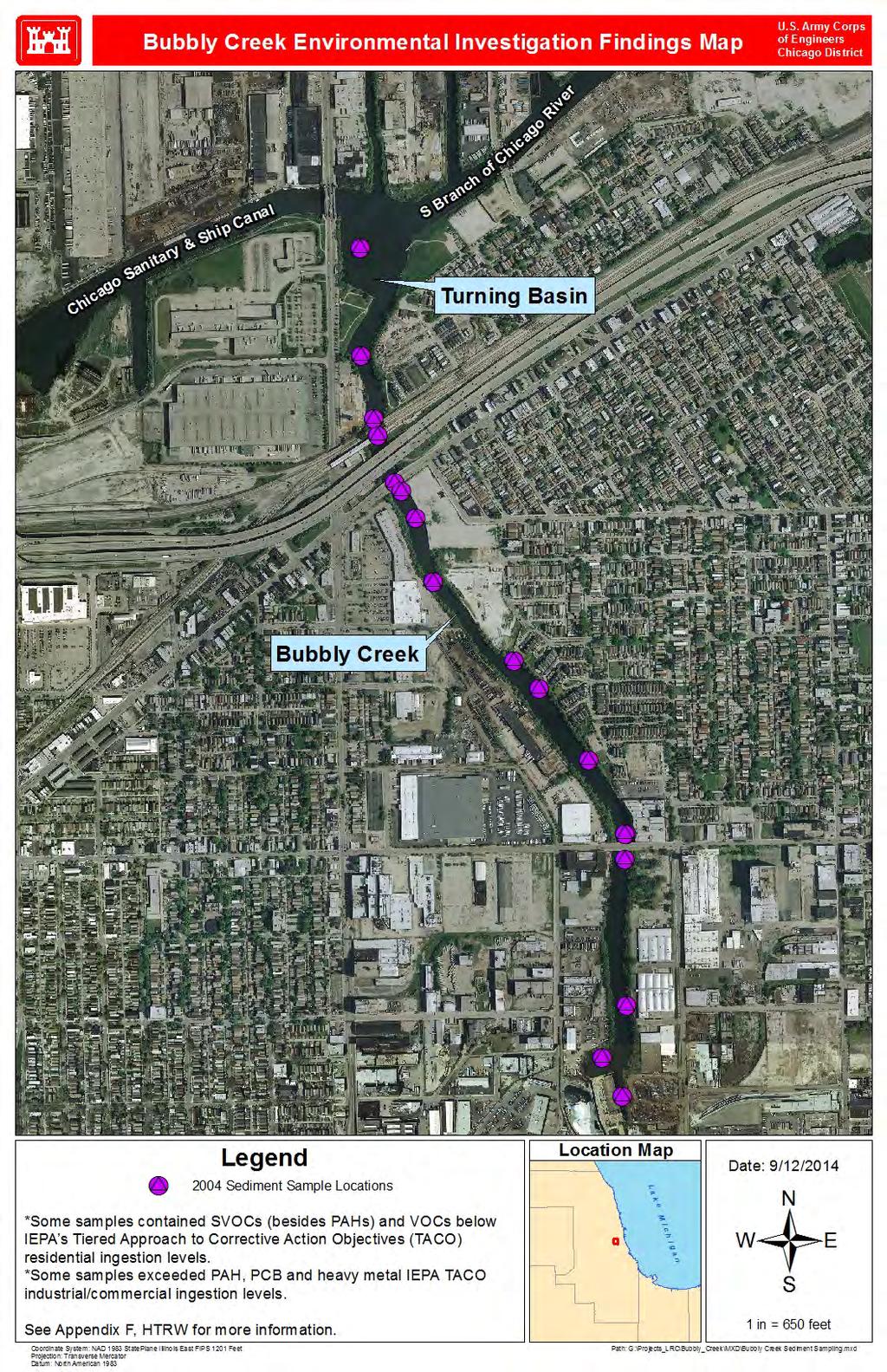
12 14. ZONING The enactment of zoning ordinances will not be required for this project. 15. ACQUISITION SCHEDULE WITH MILESTONES: The major project milestones are as follows: Request HQ Non-Standard Estate Approval November 2014 Approval of Non-Standard Estate by HQ December 2014 Commence RE Acquisition September 2015 Real Estate Available September 2017 Award Const. Contract September 2017 Begin Construction +4 months Complete Construction 2025 No detailed project schedule or milestones are available at this time. The Non-Federal Sponsor understands they must acquire all real estate required for the project and provide all necessary Right of Entry for construction prior to the beginning of construction. 16. FACILITY OR UTILITY RELOCATIONS Plans and Specifications do not identify any utilities/facilities that will need to be relocated. 17. ENVIRONMENTAL A U.S. Army Corps of Engineers Environmental Baseline Study/Phase I HTRW investigation was conducted through a review of existing project information and database review. The most significant source of HTRW is the substrate sediment of the streambed due to years of unregulated industrial activity. Sediments are not considered hazardous waste based on reactivity but sulfide levels will need to be considered along with other sediment data when making decisions concerning material handling and disposal. If any HTRW is encountered during project executions, the sponsor shall be responsible for development and implementation of any required response action at 100% non-federal expense. See Exhibit B 18. PROJECT SUPPORT The City of Chicago is a willing sponsor and fully supports the Project. There is no public opposition anticipated. 19. RISK NOTIFICATION A risk notification letter has not been sent out. 20. OTHER RELEVANT REAL ESTATE ISSUES There are no cemeteries within the project area. There are no special aquatic sites, including wetlands, impacted by the project. 8
13 The Detroit District Real Estate Division will coordinate, monitor and assist with all real estate activities undertaken by the Non-Federal Sponsor. If any acquisition activities are required by the Non-Federal Sponsor, the Real Estate Division will assure that the acquisition process is conducted in compliance with Federal and State Laws, specifically, the requirements under the Federal Uniform Relocation and Acquisition Act (P.L ). The Real Estate Division will also attend district team meetings, review and provide input into draft and final reports prepared by the district team, and participate in the ATR. 9
14 EXHIBIT A: Bubbly Creek Project Map U.S. Army Corps of Engineers Chicago District Appendix G Real Estate Bubbly Creek, Chicago, Illinois

15 Bubbly Creek Real Estate Map U.S. Army Corps of Engineers Chicago District NS Acres Acres Acres Acres Acres Acres Acres Acres Acres Acres Legend Location Map Date: 9/9/2014 Parcels Ecosystem = 6.56 Acres L a k e M i c h i g a n FEE Simple = Acres Road = 1.20 Acres *Ordinary High Water Mark is Feet 1 in = 150 feet Coordinate System: NAD 1983 StatePlane Illinois East FIPS 1201 Feet Projection: Transverse Mercator Datum: North American 1983 Path: G:\Projects_LRC\Bubbly_Creek\MXD\Bubbly Creek Real Estate Map_SEP14.mxd
16 Acres Bubbly Creek Real Estate Map U.S. Army Corps of Engineers Chicago District Acres EE Acres RD -.11 ACRES Acres Acres Acres Acres Acres Acres Acres Acres Acres Acres Acres Acres RD -.30 Acres RD -.01 Acres EE -.22 Acres RD -.11 Acres Acres Acres Acres Acres Acres Acres Acres Legend Location Map Date: 9/9/2014 Parcels Ecosystem = 6.56 Acres L a k e M i c h i g a n FEE Simple = Acres Road = 1.20 Acres *Ordinary High Water Mark is Feet 1 in = 250 feet Coordinate System: NAD 1983 StatePlane Illinois East FIPS 1201 Feet Projection: Transverse Mercator Datum: North American 1983 Path: G:\Projects_LRC\Bubbly_Creek\MXD\Bubbly Creek Real Estate Map_SEP14.mxd
17 Bubbly Creek Real Estate Map.18 Acres U.S. Army Corps of Engineers Chicago District Acres Acres EE -.12 Acres RD -.10 Acres EE -.33 Acres RD -.09 Acres Acres Acres Acres Acres EE -.17 Acres RD -.11 Acres Acres Acres Acres Acres Acres EE -.04 Acres RD -.09 Acres Acres Acres EE Acres RD -.23 Acres Acres Acres Legend Location Map Date: 9/9/2014 Parcels Ecosystem = 6.56 Acres L a k e M i c h i g a n FEE Simple = Acres Road = 1.20 Acres *Ordinary High Water Mark is Feet 1 in = 250 feet Coordinate System: NAD 1983 StatePlane Illinois East FIPS 1201 Feet Projection: Transverse Mercator Datum: North American 1983 Path: G:\Projects_LRC\Bubbly_Creek\MXD\Bubbly Creek Real Estate Map_SEP14.mxd
18 EXHIBIT B: Bubbly Creek Environmental Investigation Findings Map U.S. Army Corps of Engineers Chicago District Appendix G Real Estate Bubbly Creek, Chicago, Illinois
19
20 EXHIBIT C: Detroit Real Estate Assessment of Non-Federal Sponsor s Real Estate Acquisition Capability U.S. Army Corps of Engineers Chicago District Appendix G Real Estate Bubbly Creek, Chicago, Illinois
21 EXHIBIT C DETROIT REAL ESTATE ASSESSMENT OF NON-FEDERAL SPONSOR S REAL ESTATE ACQUISITION CAPABILITY Project, City of Chicago A. LEGAL AUTHORITY: 07 August It has been determined that the sponsor has legal authority to acquire and hold title to real property for project purposes? (Yes/No) 2. It has been determined that the sponsor has the power of eminent domain for this project. (Yes/No) 3. It has been determined that the sponsor has quick-take authority for this project? (Yes/No) 4. Are any lands/interests in land required for the project located outside the sponsor s political boundary, and whether this limits its ability to acquire property? (Yes/No). 5. A determination has been made as to whether any of the lands/interests in land required for the project are owned by an entity whose property the sponsor cannot condemn? (Yes/No) B. FINANCIAL CAPABILITY: 1. It has been established by the responsible district element that the local sponsor is financially capable of fulfilling all requirements of local cooperation. (Yes/No) C. WILLINGNESS TO PARITICIPATE: 1. Sponsor has stated in writing their general willingness to participate in the project and their understanding of the general scope of the project and their part of the project. (Yes/No) 2. In addition, they are agreeable to signing a Project Partnership Agreement (PPA) and supplying funding as stipulated in the agreement. (Yes/No) 14
22 3. The sponsor has approved the project/real estate schedule/milestone. (Yes/No) 4. The sponsor has participated in other USACE projects satisfactorily. (Yes/No/Not Applicable) 5. With regard to this project, the sponsor is anticipated to be highly capable/fully capable/ moderately capable/marginally capable/insufficiently capable. (If sponsor is believed to be insufficiently capable, provide explanation.) D. ACQUISITION EXPERIENCE AND CAPABILITY 1. Sponsor has on board capability/in house staffing within their organization or contract capability to provide the necessary services such as surveying, appraising, title, negotiating, condemnation, closings, and relocation assistance that will be required for the acquisition of properties. (Yes/No) 2. It has been determined that the sponsor s staff will not required training to become familiar with the real estate requirements of Federal projects including P.L , as amended? (Yes/No) 3. It has been determined that the sponsor can obtain contractor support, if required, in a timely fashion. (Yes/No) 4. The sponsor s staff will be located within reasonable proximity to the project site. (Yes/No) 5. A determination has been made as to whether USACE assistance will likely be requested by the local sponsor in acquiring real estate. (Yes/No) E. SCHEDULE CAPABILITY: 1. Sponsor has indicated in writing their willingness and ability to incorporate their financial acquisition and condemnation capability to provide the necessary project LERRDs in accordance with proposed project schedules so the Government can advertise and award the construction contract as required by overall project schedule and funding limitations. (Yes/No F. LERRD CREDITS: 15
23 1. Sponsor has indicated their understanding of LERRD credits and their capability and willingness to gather the necessary information to submit as LERRD credits within six months after possession of all real estate and completion of relocations in order that the project can be financially closed out and there can be a final financial accounting with a proper settlement with the sponsor. (Yes/No) G. COORDINATION: 1. This assessment has been coordinated with the local sponsor and they concur with the assessment? (Yes/No) Prepared by: Paula M. Kohl Realty Specialist Reviewed and approved by: Victor L. Kotwicki Real Estate Contracting Officer Buffalo, Chicago, and Detroit District 16
JANUARY 2016 MAMARONECK & SHELDRAKE RIVERS NEW YORK FLOOD RISK MANAGEMENT GENERAL REEVALUATION REPORT FOR THE VILLAGE OF MAMARONECK APPENDIX E
 U.S. Army Corps of Engineers New York District MAMARONECK & SHELDRAKE RIVERS NEW YORK FLOOD RISK MANAGEMENT GENERAL REEVALUATION REPORT FOR THE VILLAGE OF MAMARONECK JANUARY 2016 APPENDIX E REAL ESTATE
Appendix B Draft Real Estate Plan
 Appendix B Draft Real Estate Plan B-1 REAL ESTATE PLAN Prepared for U.S. Army Corps of Engineers Southwestern Division Little Rock District As of December 3, 2012 Prepared by Ronald Bridges Real Estate
DRAFT INTEGRATED FEASIBILITY REPORT AND ENVIRONMENTAL ASSESSMENT
 APPENDIX E REAL ESTATE PLAN MT. SINAI MEDICAL CENTER, CONTINUTING AUTHORITIES PROGRAM (CAP) SECTION 14, PROJECT DRAFT INTEGRATED FEASIBILITY REPORT AND ENVIRONMENTAL ASSESSMENT September 2016 DRAFT APPENDIX
APPENDIX D - REAL ESTATE
 APPENDIX D - REAL ESTATE 1. Purpose Real Estate Plan For Feasibility Study For Lake Lou Yaeger Section 206 Aquatic Ecosystem Restoration Continuing Authorities Project Feasibility Study This report is
Appendix G. Non-Federal Letters of Support and Draft Real Estate Plan
 Appendix G Non-Federal Letters of Support and Draft Real Estate Plan REAL ESTATE PLAN UPPER DELAWARE RIVER WATERSHED FEASABILITY STUDY LIVINGSTON MANOR, NEW YORK 1. GENERAL 2. REAL ESTATE REQUIREMENTS
Appendix B Real Estate Plan
 Appendix B Real Estate Plan B-1 REAL ESTATE PLAN Prepared for U.S. Army Corps of Engineers Southwestern Division Little Rock District As of May 1, 2013 Prepared by Ronald Bridges Real Estate Division ANY
Draft Continuing Authorities Program Section 1135 Detailed Project Report and Integrated Environmental Assessment
 Appendix G Real Estate Shorty s Island / Meander Reach Ecosystem Restoration Kootenai River, Idaho Draft Continuing Authorities Program Section 1135 Detailed Project Report and Integrated Environmental
Appendix C. Real Estate. Brazos Island Harbor, Texas Channel Improvement Project Cameron County, Texas
 Appendix C Real Estate Brazos Island Harbor, Texas Channel Improvement Project Cameron County, Texas U.S. Army Corps of Engineers, Galveston District 2000 Fort Point Road Galveston, Texas 77550 December
Delaware River Basin Comprehensive Flood Risk Management Interim Feasibility Study and Integrated Environmental Assessment for New Jersey
 Delaware River Basin Comprehensive Flood Risk Management Interim Feasibility Study and Integrated Environmental Assessment for New Jersey Flooding in the Study Area, April 2005 June 2015 APPENDIX F: Draft
EDISTO BEACH COASTAL STORM DAMAGE REDUCTION GENERAL INVESTIGATION STUDY APPENDIX K REAL ESTATE
 EDISTO BEACH COASTAL STORM DAMAGE REDUCTION GENERAL INVESTIGATION STUDY APPENDIX K REAL ESTATE Table of Contents REAL ESTATE APPENDIX... I... i SECTION 1. THE REAL ESTATE REPORT... 1 1.1 Statement of Purpose...
INDIANA HARBOR AND CANAL CONFINED DISPOSAL FACILITY EAST CHICAGO, INDIANA
 INDIANA HARBOR AND CANAL CONFINED DISPOSAL FACILITY EAST CHICAGO, INDIANA APPENDIX J REAL ESTATE Acquisition Branch Real Estate Division Chicago District U.S. Army Corps of Engineers APPENDIX J REAL ESTATE
APPENDIX M. Real Estate Plan
 APPENDIX M Real Estate Plan Poplar Island Environmental Restoration Project September 2005 General Reevaluation Report (GRR) and Supplemental Environmental Impact Statement (SEIS) REAL ESTATE PLAN (REP)
APPENDIX C REAL ESTATE PLAN BOULEVARD RESACA, BROWNSVILLE, TX CAMERON COUNTY, TEXAS
 APPENDIX C REAL ESTATE PLAN BOULEVARD RESACA, BROWNSVILLE, TX CAMERON COUNTY, TEXAS November 19, 2016 Table of Contents Purpose... 3 Project Authority... 3 Project Location and Description... 3 Non-Federal
Appendix H: Real Estate Plan
 APPENDIX H Spring Creek North Ecosystem Restoration Feasibility Study Appendix H: Real Estate Plan New York District U.S. Army Corps of Engineers October 2016 Revised: 13 April 2017 Spring Creek North
MAMARONECK AND SHELDRAKE RIVER FLOOD DAMAGE REDUCTION PROJECT MAMARONECK, NEW YORK APPENDIX E REAL ESTATE PLAN
 U.S. Army Corps of Engineers New York District MAMARONECK AND SHELDRAKE RIVER FLOOD DAMAGE REDUCTION PROJECT MAMARONECK, NEW YORK APPENDIX E REAL ESTATE PLAN April 2017 MAMARONECK AND SHELDRAKE RIVER FLOOD
WEST SHORE LAKE PONTCHARTRAIN HURRICANE AND STORM DAMAGE RISK REDUCTION STUDY INTEGRATED DRAFT FEASIBILITY REPORT AND ENVIRONMENTAL IMPACT STATEMENT
 WEST SHORE LAKE PONTCHARTRAIN HURRICANE AND STORM DAMAGE RISK REDUCTION STUDY INTEGRATED DRAFT FEASIBILITY REPORT AND ENVIRONMENTAL IMPACT STATEMENT REAL ESTATE PLAN APPENDIX C Annex A: Project Maps Annex
DRAFT REAL ESTATE PLAN APPENDIX D JEFFERSON COUNTY ECOSYSTEM RESTORATION FEASIBILITY STUDY
 DRAFT REAL ESTATE PLAN APPENDIX D JEFFERSON COUNTY ECOSYSTEM RESTORATION FEASIBILITY STUDY (NOTE: This page intentionally left blank.) This Real Estate Plan has been prepared in accordance with ER 405-1-12
Appendix K. Real Estate Plan
 Appendix K. Real Estate Plan REAL ESTATE PLAN DELTA ISLANDS AND LEVEES FEASIBILITY STUDY (DELTA STUDY) 20 June 2018 PREPARED BY THE SACRAMENTO DISTRICT U.S. ARMY CORPS OF ENGINEERS 1 TABLE OF CONTENTS
APPENDIX E REAL ESTATE PLAN
 APPENDIX E REAL ESTATE PLAN REAL ESTATE PLAN VILLAGE OF BARBOURSVILLE, WATER STREET, STREAMBANK PROTECTION PROJECT CABELL COUNTY, WEST VIRGINIA SECTION 14 1. Authority/Purpose This Real Estate Plan is
Draft Appendix E. Real Estate Plan. Rahway River Basin, New Jersey Flood Risk Management Feasibility Study. November 2016
 Draft Appendix E Real Estate Plan Rahway River Basin, New Jersey Flood Risk Management Feasibility Study November 2016 New Jersey Department of Environmental Protection U.S. Army Corps of Engineers New
REAL ESTATE PLAN APPENDIX G
 Pacific Ocean Division REAL ESTATE PLAN APPENDIX G Alaska District UNALASKA (DUTCH HARBOR) CHANNELS UNALASKA, ALASKA Real Estate Division Alaska District U.S. Army Corps of Engineers TABLE OF CONTENTS
APPENDIX F REAL ESTATE
 APPENDIX F REAL ESTATE Real Estate Plan For Broward County, Florida Shore Protection Project Segments II and III General Reevaluation Report 1. Statement Of Purpose. The Real Estate Plan is tentative in
HASHAMOMUCK COVE, SOUTHOLD, NEW YORK COASTAL STORM RISK MANAGEMENT FEASIBILITY STUDY APPENDIX F REAL ESTATE PLAN
 U.S. Army Corps of Engineers New York District HASHAMOMUCK COVE, SOUTHOLD, NEW YORK COASTAL STORM RISK MANAGEMENT FEASIBILITY STUDY APPENDIX F REAL ESTATE PLAN AUGUST 2016 HASHAMOMUCK COVE, SOUTHOLD, NEW
Draft Environmental Impact Statement (EIS)/Environmental Impact Report (EIR) APPENDIX H Real Estate Cost
/Environmental Impact Report (EIR) APPENDIX H Real Estate Cost") Draft Environmental Impact Statement (EIS)/Environmental Impact Report (EIR) APPENDIX H Real Estate Cost US Army Corps of Engineers Corte Madera Creek Flood Risk Management Project October 2018 APPENDIX
Draft Environmental Impact Statement (EIS)/Environmental Impact Report (EIR) APPENDIX H Real Estate Cost US Army Corps of Engineers Corte Madera Creek Flood Risk Management Project October 2018 APPENDIX
Draft Integrated Feasibility Report and Environmental Assessment and Draft Finding of No Significant Impact
 Draft Integrated Feasibility Report and Environmental Assessment and Draft Finding of No Significant Impact APPENDIX F: REAL ESTATE Whittier, Alaska June 2018 Pacific Ocean Division DRAFT REAL ESTATE
APPENDIX H REAL ESTATE REQUIREMENTS
 Malden River Ecosystem Restoration Detailed Project Report APPENDIX H REAL ESTATE REQUIREMENTS April 2007 Malden River Ecosystem Restoration Real Estate Report 1. PURPOSE: The Detailed Project Report
UPPER MISSISSIPPI RIVER RESTORATION FEASIBILITY REPORT WITH INTEGRATED ENVIRONMENTAL ASSESSMENT
 UPPER MISSISSIPPI RIVER RESTORATION FEASIBILITY REPORT WITH INTEGRATED ENVIRONMENTAL ASSESSMENT McGregor Lake HABITAT REHABILITATION AND ENHANCEMENT PROJECT POOL 10, UPPER MISSISSIPPI RIVER MILE 635-634
DRAFT East Rockaway Inlet to Rockaway Inlet and Jamaica Bay. Atlantic Coast of New York
 DRAFT East Rockaway Inlet to Rockaway Inlet and Jamaica Bay Atlantic Coast of New York APPENDIX E REAL ESTATE PLAN AUGUST 2018 East Rockaway Inlet to Rockaway Inlet and Jamaica Bay Reformulation Study
Appendix J. Real Estate Plan
 Appendix J Real Estate Plan Real Estate Plan Louisiana Coastal Area Near-Term Ecosystem Restoration Plan Medium Diversion at White Ditch 1. PURPOSE Title VII of the Water Resources Development Act of 2007
DEPARTMENT OF THE ARMY OFFICE OF THE CHIEF OF ENGINEERS WASHINGTON, D.C
 DEPARTMENT OF THE ARMY OFFICE OF THE CHIEF OF ENGINEERS WASHINGTON, D.C. 20314-1000 REPLY TO ATTENTION OF: CECW-PM (10-1-7a) THE SECRETARY OF THE ARMY 1. I submit for transmission to Congress my report
UPPER MISSISSIPPI RIVER RESTORATION FEASIBILITY REPORT WITH INTEGRATED ENVIRONMENTAL ASSESSMENT
 UPPER MISSISSIPPI RIVER RESTORATION FEASIBILITY REPORT WITH INTEGRATED ENVIRONMENTAL ASSESSMENT BEAVER ISLAND HABITAT REHABILITATION AND ENHANCEMENT PROJECT POOL 14, UPPER MISSISSIPPI RIVER MILES 513.0-517.0
Appendix D Real Estate Plan
 Appendix D Real Estate Plan Matagorda Ship Channel, Port Lavaca, Texas Feasibility Report and Environmental Impact Statement, Review of Completed Projects, Calhoun and Matagorda Counties May 2018 (NOTE:
APPENDIX D REAL ESTATE PLAN
 APPENDIX D REAL ESTATE PLAN APPENDIX D REAL ESTATE PLAN TABLE OF CONTENTS 1. STATEMENT OF PURPOSE 2. REFERENCES 3. AUTHORIZATION 4. BACKGROUND 5. LOCATION 6. REAL ESTATE REQUIREMENTS 7. OWNERSHIP OF REAL
HUNTING BAYOU FLOOD RISK MANAGEMENT, HARRIS COUNTY, TEXAS DRAFT GENERAL REEVALUATION REPORT AND INTEGRATED ENVIRONMENTAL ASSESSMENT
 HUNTING BAYOU FLOOD RISK MANAGEMENT, HARRIS COUNTY, TEXAS DRAFT GENERAL REEVALUATION REPORT AND INTEGRATED ENVIRONMENTAL ASSESSMENT APPENDIX 6 REAL ESTATE PLAN June 2014 HARRIS COUNTY FLOOD CONTROL DISTRICT
Southwest Coastal Louisiana Study
 REAL ESTATE PLAN Annex 1: Project Maps Annex 2: Assessment of Non-Federal Sponsor s Acquisition Capability Annex 3: Non-Material Deviation from Standard Estate Perpetual Access Easement Annex 4: Baseline
Appendix D: Real Estate
 Shrewsbury River Basin, Sea Bright, New Jersey Coastal Storm Risk Management Feasibility Study Draft Integrated Feasibility Report & Environmental Assessment Appendix D: Real Estate Shrewsbury River Basin,
GENERAL RE-EVALUATION REPORT APPENDIX B: REAL ESTATE SAVANNAH HARBOR EXPANSION PROJECT Chatham County, Georgia and Jasper County, South Carolina
 GENERAL RE-EVALUATION REPORT APPENDIX B: REAL ESTATE SAVANNAH HARBOR EXPANSION PROJECT Chatham County, Georgia and Jasper County, South Carolina January 2012 (Revised July 2012) US Army Corps of Engineers
APPENDIX H. Real Estate Plan
 INTEGRATED FEASIBILITY REPORT AND ENVIRONMENTAL IMPACT STATEMENT COASTAL STORM DAMAGE REDUCTION BOGUE BANKS, CARTERET COUNTY NORTH CAROLINA APPENDIX H Real Estate Plan US Army Corps of Engineers Wilmington
U.S. Army Corps of Engineers Charleston District APPENDIX E CHARLESTON HARBOR POST 45 CHARLESTON, SOUTH CAROLINA. Real Estate
 U.S. Army Corps of Engineers Charleston District APPENDIX E CHARLESTON HARBOR POST 45 CHARLESTON, SOUTH CAROLINA Real Estate May 2015 Table of Contents REAL ESTATE APPENDIX E... I... i... i SECTION 1.
Final General Reevaluation Report and Final Environmental Impact Statement. Hurricane Protection and Beach Erosion Control
 Final General Reevaluation Report and Final Environmental Impact Statement on Hurricane Protection and Beach Erosion Control WEST ONSLOW BEACH AND NEW RIVER INLET (TOPSAIL BEACH), NORTH CAROLINA Appendix
Real Estate Plan Beaver Lake Water Supply Reallocation White River Rogers, Arkansas. 20 April 2017
 Real Estate Plan Beaver Lake Water Supply Reallocation White River Rogers, Arkansas 20 April 2017 Prepared For US Army Corps of Engineers Southwestern Division Little Rock District Prepared By Jeremy R.
Dredged Material Management Plan Atlantic Intracoastal Waterway Port Royal Sound, South Carolina to Cumberland Sound, Georgia November 2015
 Dredged Material Management Plan Atlantic Intracoastal Waterway Port Royal Sound, South Carolina to Cumberland Sound, Georgia November 2015 Appendix H: Real Estate US Army Corps of Engineers South Atlantic
DRAFT REAL ESTATE PLAN APPENDIX C GULF INTRACOASTAL WATERWAY BRAZOS RIVER FLOODGATES AND COLORADO RIVER LOCKS SYSTEMS FEASIBILITY STUDY
 DRAFT REAL ESTATE PLAN APPENDIX C GULF INTRACOASTAL WATERWAY BRAZOS RIVER FLOODGATES AND COLORADO RIVER LOCKS SYSTEMS FEASIBILITY STUDY This Real Estate Plan has been prepared in accordance with ER 405-1-12
REAL ESTATE PLAN. Final Integrated General Reevaluation Report and Supplemental Environmental Impact Statement
 REAL ESTATE PLAN Final Integrated General Reevaluation Report and Supplemental Environmental Impact Statement Mississippi River, Baton Rouge to the Gulf of Mexico Mississippi River-Gulf Outlet, Louisiana,
DEPARTMENT OF THE ARMY OFFICE OF THE CHIEF OF ENGINEERS WASHINGTON. D.C MAR
 DEPARTMENT OF THE ARMY OFFICE OF THE CHIEF OF ENGINEERS WASHINGTON. D.C. 2031 4-1 000 MAR 3 1 2006 CEMP-NAD (1 0-1-7a) THE SECRETARY OF THE ARMY 1. I submit for transmission to Congress my report on the
Skagit River Flood Risk Management General Investigation Skagit County, Washington. Draft Feasibility Report and Environmental Impact Statement
 General Investigation Skagit County, Washington Draft Feasibility Report and Environmental Impact Statement May 2014 Real Estate Requirements of Selected Plan This Real Estate Plan Summary (REP) is presented
APPENDIX F REAL ESTATE PLAN. Redwood City Harbor Navigation Improvement Feasibility Study, Redwood City, California
 APPENDIX F REAL ESTATE PLAN Redwood City Harbor Navigation Improvement Feasibility Study, Redwood City, California PREPARED FOR THE SAN FRANCISCO DISTRICT SOUTH PACIFIC DIVISION 20 April 2015 PREPARED
BEACH STORM DAMAGE REDUCTION EASEMENT
 STATE OF FLORIDA COUNTY OF WALTON WALTON COUNTY, FL HURRICANE & STORM DAMAGE REDUCTION PROJECT FILE/REACH#: PARCEL ID#: BEACH STORM DAMAGE REDUCTION EASEMENT KNOW ALL MEN BY THESE PRESENTS, that for and
CENAN-RE 22 May MEMORANDUM FOR Chief, Planning Division, ATTN: CENAN-PL-F (Alek Petersen)
") CENAN-RE 22 May 2017 MEMORANDUM FOR Chief, Planning Division, ATTN: CENAN-PL-F (Alek Petersen) SUBJECT: May 2017 Real Estate Plan for the Rahway River (Tidal) Basin, Coastal Storm Risk Management Feasibility
CENAN-RE 22 May 2017 MEMORANDUM FOR Chief, Planning Division, ATTN: CENAN-PL-F (Alek Petersen) SUBJECT: May 2017 Real Estate Plan for the Rahway River (Tidal) Basin, Coastal Storm Risk Management Feasibility
Downtown Montauk Stabilization Project. Real Estate Plan Appendix
 Downtown Montauk Stabilization Project Real Estate Plan Appendix October 2014 Table of Contents Page 1. Introduction and General Information 1 a. Authority 2 b. History 2 c. Location Project Study Area
Submittal of the Minutes from the March 9, 2011, April 5, 2011, and April 19, 2011 Cabinet Meetings.
 AGENDA BOARD OF TRUSTEES OF THE INTERNAL IMPROVEMENT TRUST FUND JUNE 16, 2011 Attachments to the items below can be viewed at the following link: http://www.dep.state.fl.us/secretary/cab/public_notices.htm
AGREEMENT TO ACQUIRE LANDS BETWEEN THE DEPARTMENT OF THE ARMY ST. PAUL DISTRICT, CORPS OF ENGINEERS AND. THE CITY OF City, State
 AGREEMENT TO ACQUIRE LANDS BETWEEN THE DEPARTMENT OF THE ARMY ST. PAUL DISTRICT, CORPS OF ENGINEERS AND THE CITY OF City, State FOR CONDEMNATION ON BEHALF OF THE SPONSOR BY THE CORPS OF ENGINEERS FOR THE
APPENDIX H REAL ESTATE PLAN
 APPENDIX H REAL ESTATE PLAN This page intentionally left blank. APPENDIX H REAL ESTATE PLAN DALLAS FLOODWAY FEASIBILITY STUDY DATE OF REPORT January 31, 2014 PREPARED BY REAL ESTATE DIVISION U.S. ARMY
Appendix C REAL ESTATE PLAN
 Appendix C RAL STAT PLAN Section 203 Integrated Feasibility Report and Draft nvironmental Impact Statement RAL STAT PLAN HOUMA NAVIGATION CANAL CHANNL DPNING MIL 36.3 TO MIL 3.7 TRRBONN PARISH, LOUISIANA
AMENDED DEED OF CONSERVATION EASEMENT
 Prepared by: Wayne E. Flowers Lewis, Longman & Walker, P.A. 245 Riverside Ave. Suite 150 Jacksonville, FL 32202 Return recorded original to: Mitigation Marketing 1091 W. Morse Blvd. Suite 101 Winter Park,
DEPARTMENT OF THE ARMY U.S. ARMY CORPS OF ENGINEERS, SAVANNAH DISTRICT 100 WEST OGLETHORPE AVENUE SAVANNAH, GEORGIA
 DEPARTMENT OF THE ARMY U.S. ARMY CORPS OF ENGINEERS, SAVANNAH DISTRICT 100 WEST OGLETHORPE AVENUE SAVANNAH, GEORGIA 31401-3604 June 8, 2018 Regulatory Branch SAS-2018-00375 PUBLIC NOTICE Reissuance of
DEPARTMENT OF THE ARMY U.S. Army Corps of Engineers Washington, DC Regulation No May 2015
 CEMP-CR DEPARTMENT OF THE ARMY U.S. Army Corps of Engineers Washington, DC 20314-1000 ER 405-1-19 Regulation No. 405-1-19 29 May 2015 Real Estate ACQUISITION BY CONDEMNATION PROCEEDINGS 1. Purpose. Engineer
Shoreline Use Permits
 The primary objective of the Corps of Engineers in the management of the Table Rock Lake shoreline is to insure the general public full recreational enjoyment and fish and wildlife benefits on public lands
PUGET SOUND NEARSHORE ECOSYSTEM RESTORATION
 PUGET SOUND NEARSHORE ECOSYSTEM RESTORATION APPENDIX C REAL ESTATE PLAN Integrated Feasibility Report and Environmental Impact Statement This page was intentionally left blank to facilitate double sided
DECLARATION OF RESTRICTIVE COVENANTS. THIS DECLARATION OF RESTRICTIVE COVENANTS made this day of, 200_, by ( Declarant ). RECITALS
. RECITALS") DECLARATION OF RESTRICTIVE COVENANTS THIS DECLARATION OF RESTRICTIVE COVENANTS made this day of, 200_, by ( Declarant ). RECITALS WHEREAS, Declarant is the owner of the surface of certain real property
DECLARATION OF RESTRICTIVE COVENANTS THIS DECLARATION OF RESTRICTIVE COVENANTS made this day of, 200_, by ( Declarant ). RECITALS WHEREAS, Declarant is the owner of the surface of certain real property
THIS DECLARATION OF RESTRICTIVE COVENANTS is made this day of, 20, by ("Covenantor"). RECITALS
. RECITALS") Model for Use with Permits Without Mitigation Plans STATE OF COUNTY OF DECLARATION OF RESTRICTIVE COVENANTS THIS DECLARATION OF RESTRICTIVE COVENANTS is made this day of, 20, by ("Covenantor"). RECITALS
Model for Use with Permits Without Mitigation Plans STATE OF COUNTY OF DECLARATION OF RESTRICTIVE COVENANTS THIS DECLARATION OF RESTRICTIVE COVENANTS is made this day of, 20, by ("Covenantor"). RECITALS
FLORIDA DEPARTMENT OF ENVIRONMENTAL PROTECTION
 FLORIDA DEPARTMENT OF ENVIRONMENTAL PROTECTION NOTICE OF INTENT TO USE S. 403.9327, F.S., GENERAL PERMIT FOR MANGROVE TRIMMING OR APPLICATION FOR S. 403.9328, F.S., INDIVIDUAL PERMIT TO TRIM OR ALTER MANGROVES
REAL ESTATE PLAN APPENDIX G
 Pacific Ocean Division REAL ESTATE PLAN APPENDIX G Alaska District KENAI BLUFFS BANK STABILIZATION SECTION 116 FEASIBILITY STUDY KENAI, ALASKA Real Estate Branch Alaska District U.S. Army Corps of Engineers
DECLARATION OF RESTRICTIVE COVENANTS
 DECLARATION OF RESTRICTIVE COVENANTS The Declarant,, is the fee simple owner of the certain real property located in County, Kansas, as described on Exhibit A, which is attached hereto and incorporated
MODEL DEED RESTRICTION FOR THE PENNSYLVANIA STATE PROGRAMMATIC GENERAL PERMIT-3 (PASPGP-3) DECLARATION OF RESTRICTIVE COVENANTS FOR CONSERVATION
 DECLARATION OF RESTRICTIVE COVENANTS FOR CONSERVATION") MODEL DEED RESTRICTION FOR THE PENNSYLVANIA STATE PROGRAMMATIC GENERAL PERMIT-3 (PASPGP-3) DECLARATION OF RESTRICTIVE COVENANTS FOR CONSERVATION THIS DECLARATION OF RESTRICTIVE COVENANTS FOR CONSERVATION
MODEL DEED RESTRICTION FOR THE PENNSYLVANIA STATE PROGRAMMATIC GENERAL PERMIT-3 (PASPGP-3) DECLARATION OF RESTRICTIVE COVENANTS FOR CONSERVATION THIS DECLARATION OF RESTRICTIVE COVENANTS FOR CONSERVATION
Federal Mandates and Willing Sellers: Real Estate Acquisition for the Missouri River Recovery Program
 Federal Mandates and Willing Sellers: Real Estate Acquisition for the Missouri River Recovery Program Brad Thompson, Chief, Civil Works Branch U.S. Corps of Engineers, Omaha District US Army Corps of Engineers
DECLARATION OF RESTRICTIVE COVENANTS
 STATE OF MARYLAND COUNTY OF DECLARATION OF RESTRICTIVE COVENANTS THIS DECLARATION OF RESTRICTIVE COVENANTS is made this day of, 20, by ( Declarant(s) ). RECITALS WHEREAS, Declarant(s) is/are the owner(s)
ORDINANCE NO WHEREAS, the Town of Jupiter ( Town ) has adopted a Comprehensive Plan
 has adopted a Comprehensive Plan") 0 0 ORDINANCE NO. -0 AN ORDINANCE OF THE TOWN COUNCIL OF THE TOWN OF JUPITER, FLORIDA, AMENDING CHAPTER OF THE TOWN CODE TO AMEND SECTION -, ENTITLED INTENT TO ADD PERMITTING LANDGUAGE; TO AMEND SECTION
0 0 ORDINANCE NO. -0 AN ORDINANCE OF THE TOWN COUNCIL OF THE TOWN OF JUPITER, FLORIDA, AMENDING CHAPTER OF THE TOWN CODE TO AMEND SECTION -, ENTITLED INTENT TO ADD PERMITTING LANDGUAGE; TO AMEND SECTION
Mississippi River Ship Channel Gulf to Baton Rouge, LA Integrated General Reevaluation Report And Supplemental Environmental Impact Statement
 APPENDIX B Real Estate Plan B-1.0 PROJECT PURPOSE, DESCRIPTION, LOCATION AND DESCRIPTION OF THE LANDS, EASEMENTS, RIGHTS-OF-WAY, RELOCATIONS AND DISPOSAL (LERRD) REQUIRED The purpose of this Real Estate
1. GENERAL 2. REAL ESTATE REQUIREMENTS
 1. GENERAL APPENDIX E REAL ESTATE PLAN FOR THE SECTION 205, TOOKANY CREEK FLOOD RISK MANAGEMENT FEASIBILITY STUDY TOWNSHIP, MONTGOMERY COUNTY PENNSYLVANIA 2. REAL ESTATE REQUIREMENTS a. Description of
Stormwater Ordinance Appendix APPENDIX K EXAMPLE TAR-PAM CONVERSATION EASEMENT
 APPENDIX K EXAMPLE TAR-PAM CONVERSATION EASEMENT Tax Parcel ID # NORTH CAROLINA FRANKLIN COUNTY CONSERVATION EASEMENT Franklin County, North Carolina THIS CONSERVATION EASEMENT (this "Conservation Easement")
APPENDIX D REAL ESTATE DRAFT. MOBILE HARBOR, MOBILE, ALABAMA Integrated General Reevaluation Report With Supplemental Environmental Impact Statement
 APPENDIX D REAL ESTATE DRAFT MOBILE HARBOR, MOBILE, ALABAMA Integrated General Reevaluation Report With Supplemental Environmental Impact Statement Table of Contents 1. Purpose of the Real Estate Plan
Land Management Plan Fargo-Moorhead (FM) Area Flood Risk Reduction Project Version 1
 Area Flood Risk Reduction Project Version 1") Land Management Plan Fargo-Moorhead (FM) Area Flood Risk Reduction Project Version 1 Prepared for Fargo-Moorhead Area Flood Diversion Board of Authority July 12, 2012 REV 1 Contents Section Page Acronyms
Land Management Plan Fargo-Moorhead (FM) Area Flood Risk Reduction Project Version 1 Prepared for Fargo-Moorhead Area Flood Diversion Board of Authority July 12, 2012 REV 1 Contents Section Page Acronyms
First Name Last Name. Company Name (if applicable) Street Address City State Zip. Owner Phone. . First Name Last Name
 Street Address City State Zip. Owner Phone. . First Name Last Name") MAIW 20 - APPLICATION TO PERFORM MISCELLANEOUS ACTIVITIES IN WETLANDS This EPC application is for all miscellaneous activities in wetlands (MAIW) as provided in Section 1-11.10 Wetlands, Rules of the EPC.
MAIW 20 - APPLICATION TO PERFORM MISCELLANEOUS ACTIVITIES IN WETLANDS This EPC application is for all miscellaneous activities in wetlands (MAIW) as provided in Section 1-11.10 Wetlands, Rules of the EPC.
Town of Jupiter Island Delegated Mangrove Authority For the State of Florida
 Town of Jupiter Island Delegated Mangrove Authority For the State of Florida Mangroves are regulated by the State of Florida. The Town of Jupiter Island is a delegated regulatory agency for the State for
2Q. We have owned this property for many years, why are we just now hearing about this?
 Frequently Asked Questions and Answers: 1Q. Why are you surveying the flowage easement line? 1A. The United States Army Corps of Engineers (USACE) is resurveying the actual deeded flowage easement line
City of East Providence
 City of East Providence 145 TAUNTON AVENUE, EAST PROVIDENCE STATE OF RHODE ISLAND AND PROVIDENCE PLANTATIONS 02914-4505 TEL. (401) 435-7521 FAX (401) 438-1719 TDD (401) 431-1633 CITY MANAGER PETER GRACZYKOWSKI
IRVINE UNIFIED SCHOOL DISTRICT RESOLUTION NO
 IRVINE UNIFIED SCHOOL DISTRICT RESOLUTION NO. 14-15-46 APPROVING PURCHASE AGREEMENT AND FINAL ACCEPTANCE OF REAL PROPERTY FOR THE PROPOSED PLANNING AREA (PA) 5B ELEMENTARY SCHOOL WHEREAS, the Irvine Unified
DWR REAL ESTATE COORDINATION PLAN
 DWR REAL ESTATE COORDINATION PLAN Exhibit E DWR PROPERTY ACQUISTION PLAN EXHIBIT E Revised Date: 5 10 18 DWR PROPERTY ACQUISTION PLAN EXHIBIT E Revised Date: 5-10-2018 California WaterFix Real Estate Coordination
Appendix F. Real Estate
 Appendix F Real Estate U.S. Army Corps of Engineers Galveston District Southwestern Division Appendix F Real Estate Plan for Coastal Texas Protection and Restoration Study Integrated Feasibility Report
***** Subchapter A. GENERAL PROVISIONS ***** PERMIT APPLICATIONS
 105.11. Permit requirements. 105.12. Waiver of permit requirements. Title 25 Environmental Protection Part I. Department of Environmental Protection Subpart C. Protection of Natural Resources Article I.
CURRENT THROUGH PL , APPROVED 11/11/2009
 CURRENT THROUGH PL 111-98, APPROVED 11/11/2009 TITLE 10. ARMED FORCES SUBTITLE A. GENERAL MILITARY LAW PART IV. SERVICE, SUPPLY, AND PROCUREMENT CHAPTER 159. REAL PROPERTY; RELATED PERSONAL PROPERTY; AND
CITY OF FORT COLLINS NATURAL AREAS AND CONSERVED LANDS EASEMENT POLICY
 CITY OF FORT COLLINS NATURAL AREAS AND CONSERVED LANDS EASEMENT POLICY Adopted January 3, 2012 PURPOSE: The purpose of the policy statement is to clarify the policies and procedures of the City of Fort
County of Henrico, Virginia. Buffer Management Plan. Cobbs Creek Regional Water Supply Reservoir. Task 2.1. August 21, 2013.
 County of Henrico, Virginia Buffer Management Plan Task 2.1 August 21, 2013 Prepared By: Table of Contents Buffer Management Plan Paul E. Peterson Project Manager Water Supply Reservoir Michael H. Wooden,
Central Pennsylvania Conservancy Project Selection Criteria Form
 Central Pennsylvania Conservancy Project Selection Criteria Form The following criteria guide the actions of the Central Pennsylvania Conservancy s Land Protection Committee and Board of Directors in selecting
APPLICATION. Telephone Fax Address. Telephone Fax Address FOR MARTIN COUNTY USE ONLY
 APPLICATION PRESERVE AREA MANAGEMENT PLAN/ ABBREVIATED PRESERVE AREA MANAGEMENT PLAN Growth Management Department Environmental Division PART 1: Applicant Information A. Land Owner(s) Name Title and Company
CONSERVATION EASEMENT INCLUDING MITIGATION
 After recording return to: GRANTOR: GRANTEE: GRANTEE (Trustee): LEGAL DESCRIPTION: TAX PARCEL I.D. #: REFERENCE # s: WHATCOM COUNTY N/A CONSERVATION EASEMENT INCLUDING MITIGATION This grant of a conservation
Application Procedures for Easements or Rights of Way on City of Fort Collins Natural Areas and Conserved Lands March 2012
 Application Procedures for Easements or Rights of Way on City of Fort Collins Natural Areas and Conserved Lands March 2012 IMPORTANT NOTE: This document was created to accompany the City of Fort Collins
SEQRA (For Land Surveyors) Purpose of this Presentation
 Purpose of this Presentation") SEQRA (For Land Surveyors) Purpose of this Presentation Understand the basics and legal requirements of SEQRA Recognize the role that Land Surveyors play in the SEQRA Identify the problems posed by SEQRA
SEQRA (For Land Surveyors) Purpose of this Presentation Understand the basics and legal requirements of SEQRA Recognize the role that Land Surveyors play in the SEQRA Identify the problems posed by SEQRA
NARRATIVE (GUIDELINES)
") NARRATIVE (GUIDELINES) SECTION I ACQUISITION (IF APPLICABLE, if not do not include) To be completed in narrative form by projects involving acquisitions in addition to Section II but is not required for
NARRATIVE (GUIDELINES) SECTION I ACQUISITION (IF APPLICABLE, if not do not include) To be completed in narrative form by projects involving acquisitions in addition to Section II but is not required for
ST. JOHNS COUNTY, FLORIDA South Ponte Vedra Beach, Vilano Beach, and Summer Haven Reaches
 ST. JOHNS COUNTY, FLORIDA South Ponte Vedra Beach, Vilano Beach, and Summer Haven Reaches COASTAL STORM RISK MANAGEMENT PROJECT DRAFT INTEGRATED FEASIBILITY STUDY AND ENVIRONMENTAL ASSESSMENT APPENDIX
Easement Criteria Evaluation Project: Black Gum Mitigation Bank southern Upshur County, Texas
 Easement Criteria Evaluation Project: Black Gum Mitigation Bank southern Upshur County, Texas Project Address: on the Sabine River south of Hwy 80 in southern Upshur County, Texas (entrance located about
Conservation Easement Stewardship
 Conservation Easements are effective tools to preserve significant natural, historical or cultural resources. Conservation Easement Stewardship Level of Service Standards March 2013 The mission of the
THIS DEED OF CONSERVATION EASEMENT
 NOTICE TO TITLE EXAMINERS: THIS DEED OF CONSERVATION EASEMENT CONTAINS COVENANTS THAT INCLUDE RESTRICTIONS ON THE USE, SUBDIVISION AND OFF-CONVEYANCE OF LAND. THIS DEED OF CONSERVATION EASEMENT ("Conservation
BOUNDARY MANAGEMENT AND ENCROACHMENTS
 BOUNDARY MANAGEMENT AND ENCROACHMENTS 1 255 255 255 237 237 237 0 0 0 217 217 217 163 163 163 200 200 200 Open Forum Discussion on Challenges and Best Management Practices 131 132 122 239 65 53 80 119
Establishing a Wetland Bank in Minnesota
 Establishing a Wetland Bank in Minnesota Updated February 1, 2018 This document provides a general summary of the key steps in establishing an individual wetland bank site within the state wetland banking
Upper Southampton Township US ACOE USF&WS UNH
 Upper Southampton Township US ACOE USF&WS UNH 1 Corps of Engineers Who? Heather Jensen, Project Manager Mark Eberle, Project Biologist Sarah Apperson, Jennifer McGrath, Real Estate Rich Pearsall, public
Conservation Design Subdivisions
 Conservation Design Subdivisions An excerpt from the Rules and Regulations Governing Division of Land in Sheridan County, Wyoming, November 5, 2010 Sheridan County Public Works Department 224 S. Main Street
Article III. Erosion and Sedimentation Control
 Article III. Erosion and Sedimentation Control Section 9.6 Erosion and Sedimentation Control Plan Requirements Section 9.6.1 Plan Submission A plan shall be prepared for all land-disturbing activities
MINNESOTA POLLUTION CONTROL AGENCY GENERAL PERMIT FOR DISPOSAL OF UNCOMTAMINATED CONCRETE
 MINNESOTA POLLUTION CONTROL AGENCY GENERAL PERMIT FOR DISPOSAL OF UNCOMTAMINATED CONCRETE ISSUANCE DATE: December 23, 2013 EXPIRATION DATE: December 23. 2018 This permit is a General Permit issued pursuant