County of Henrico, Virginia. Buffer Management Plan. Cobbs Creek Regional Water Supply Reservoir. Task 2.1. August 21, 2013.
|
|
|
- Letitia Bennett
- 5 years ago
- Views:
Transcription

1 County of Henrico, Virginia Buffer Management Plan Task 2.1 August 21, 2013 Prepared By:

2 Table of Contents Buffer Management Plan Paul E. Peterson Project Manager Water Supply Reservoir Michael H. Wooden, PE Deputy Project Manager Prepared for: County of Henrico, Virginia Prepared by: ARCADIS U.S., Inc Welborne Drive Suite 100 Henrico, VA Tel Fax Our Ref.: Date: August 21, 2013 August 21, 2013 i
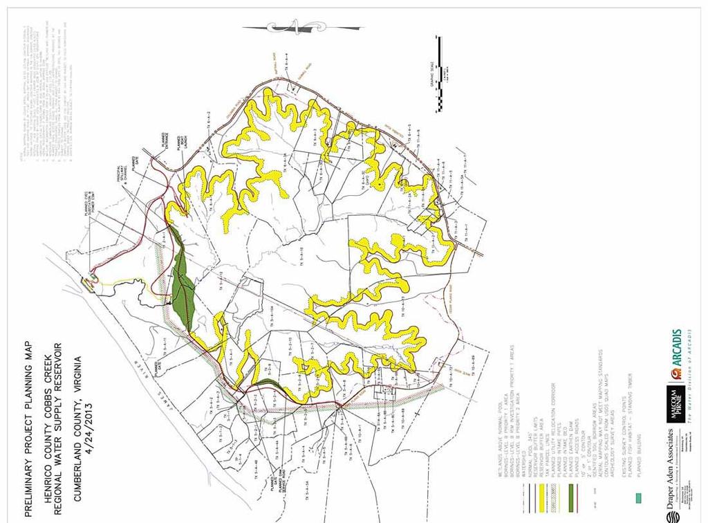
3 Table of Contents 1. BACKGROUND Cobbs Creek Reservoir Description Reservoir Buffer Purpose Applicable Permit Conditions Buffer Boundaries and Ownership 3 2. BUFFER MANAGEMENT PROVISIONS Prohibited Uses Special Exceptions Docks and Boat Ramps Enforcement 8 Figures Figure 1. Reservoir Vicinity Plan Figure 2. Reservoir Project Area 1 2 Appendices A B C Relevant DEQ and USACE Permit Language Project Planning Maps with Buffer Area Shaded in Yellow and Purple Line Showing Outer Buffer Boundary Restrictive Use Easement Language for Acquisition of Buffer Easements ii August 21, 2013
4 1. BACKGROUND 1.1 Cobbs Creek Reservoir Description The Project (Project) is being implemented by Henrico County to develop a pumped storage facility providing approximately 14.8 billion gallons of raw water storage within a 1,117-acre normal pool area. The raw water safe yield of the Project is estimated to be 47 million gallons per day. Raw water will be pumped to the reservoir from the James River when river flows are adequate, and controlled releases from reservoir storage will be made during drought and other periods when James River flows are inadequate to support regional demands and other in-stream ecological resources. The reservoir will be located near the James River in northern Cumberland County near the Town of Columbia and approximately 40 miles from Henrico County s Woodman Road Operations Center (see Figure 1). Figure 1. Reservoir Vicinity Plan The Project will include construction of a main dam to impound Cobbs Creek, a saddle dam to raise a low area of the reservoir perimeter, and a river intake, raw water pump station, transfer pipeline, and inlet/outlet tower to convey water between the James River and the reservoir. The Project will also include construction of access roads around the reservoir site and relocation of an existing utility corridor. Figure 2 shows the reservoir project area including planned facility locations and the normal pool area which is shaded in blue and corresponds to elevation 345 feet. August 21,
5 Figure 2. Reservoir Project Area The Project area is surrounded by State Route 690 (Columbia Road) and State Route 686 (Cedar Plains Road). The existing site is mostly wooded with some open pasture for cattle and horses and a well-maintained petroleum pipeline and power easement, but is largely undeveloped. The entire Project site is contained within the watershed of Cobbs Creek, which has its origins near State Routes 690 and 686, and flows north to the James River. 2 August 21, 2013
6 1.2 Reservoir Buffer Purpose This document has been prepared in fulfillment of the Virginia Department of Environmental Quality (DEQ) requirement that Henrico County submit a Buffer Management Plan (Plan) for DEQ approval. DEQ s stated purpose for this Plan is to achieve water quality protection and for controlling and abating the discharge of pollutants. Maintenance of vegetated buffers around a reservoir is an important factor in protecting and enhancing reservoir values. Buffers primarily filter runoff and can help reduce shoreline erosion when vegetation extends to the shoreline, thus helping to reduce sedimentation and protect water quality. Buffers also provide wildlife corridors and habitat. 1.3 Applicable Permit Conditions Permit conditions relevant to the Cobbs Creek Reservoir Buffer Management Plan and associated site access for inspections are included in the following permits issued to Henrico County: DEQ Virginia Water Protection Individual Permit No (Special Condition C.22 and General Condition E) United States Army Corps of Engineers (USACE) Permit No. 05-v0852/NAO (Project Specific Conditions 8, 9 and 11) The relevant DEQ and USACE permit language is presented in Appendix A. Should there be a need to modify any buffer management provisions in the future, Henrico County will submit proposed changes to DEQ and USACE for review and approval. 1.4 Buffer Boundaries and Ownership Henrico County intends to maintain a 150-foot wide reservoir buffer in accordance with the relevant DEQ and USACE permit conditions. Cobbs Creek Reservoir project planning maps are included in Appendix B which show the reservoir buffer area shaded in yellow and the outer buffer boundaries as a purple cornered line surrounding the inner blue line which represents the reservoir normal pool area. The mapped boundaries result in an estimated total reservoir buffer area of approximately 295 acres as compared to the 1,117-acre reservoir normal pool area. In some areas, the buffer may extend more than 150 feet back from the edge of the reservoir as a result of tributary streams that feed into the reservoir and must also be protected by the buffer. In other areas, the buffer width will be less than 150 feet. For example, in some areas, Columbia Road functions as the approximate watershed boundary for Cobbs Creek. Consequently, providing additional reservoir buffer east of Columbia Road would not be expected to provide additional reservoir water quality protection. Two such buffer variance areas with less than 150 feet of width are on the southeast side of the reservoir along Columbia Road. A third buffer variance area is in the northwest corner of the reservoir August 21,
7 where existing topography limits the options for the site access road alignment and Colonial Pipeline and Dominion utilities corridor realignment. Variances for each of these buffer encroachments were requested of both DEQ and USACE and subsequently approved. Other buffer requirement exceptions noted under the DEQ permit are for the main dam and the saddle dam where the constructed downstream slopes of the dams will carry runoff away from the reservoir. The property acquisition process in underway for the Project. When this process is complete, Henrico County will own the entire reservoir normal pool area up to elevation 345 feet as well as the surrounding property up to at least elevation 350 feet which approximates the simulated high water elevation under dam design storm conditions. In some cases, Henrico County ownership will extend above elevation 350 feet because of site access roads to be owned by Henrico County and some instances of property owners who wish to sell additional property above elevation 350 feet. Acquisition will include the purchase of complete parcels of land, the purchase of portions of parcels, and the purchase of utility easements and/or restrictive use easements across parcels. In total, Henrico County plans to purchase property and/or acquire easements on a total of 44 parcels from 21 different owners. The reservoir buffer will usually extend above elevation 350 feet. Consequently, some portions of the buffer will be owned by Henrico County and other portions will be retained by private property owners. In cases where private property owners will retain ownership of buffer lands, Henrico County will obtain restrictive use easements on those portions of privately owned land that fall within the reservoir buffer boundary. The specific restrictive use easement language to be used in the property acquisition process is included in Appendix C. When accessing the reservoir buffer through adjacent private property, it will be Henrico County s intent to minimize any potential property impacts and to use existing driveways, private roads or trails whenever practicable in achieving such access. 4 August 21, 2013
8 2. BUFFER MANAGEMENT PROVISIONS 2.1 Prohibited Uses The following activities are prohibited throughout the entire buffer area. In some cases, there are special exceptions to these general prohibitions which are listed separately in Section Construction of new buildings, structures, fences, roads or utilities (see special exceptions 1, 2 and 3). 2. Industrial or commercial activities (see special exception 5). 3. Storage of compost, manure, fertilizers, chemicals, machinery or equipment outside of existing buildings and structures (see special exception 6). 4. Burning, harvesting timber or otherwise removing any vegetation (see special exceptions 7 and 8). 5. Tree removal to provide for sight lines and vistas (see special exception 9). 6. Mowing, plowing, cultivating or landscaping (see special exception 10). 7. Grading, blasting, mining, or performing other earth-disturbing activities (see special exception 11). 8. Damming, impounding, capturing, or diverting flowing water. 9. Dumping or depositing waste machinery, equipment, other waste materials, household refuse, lawn clippings, woody debris, leaves or fill material. 10. Erecting or installing any billboards, signs, towers, playground equipment or recreational fields (see special exception 12). 11. Operating any motorized vehicles (see special exceptions 13 and 14). 12. Pasturing or grazing any livestock or poultry (see special exception 15). August 21,
9 2.2 Special Exceptions The following activities are allowed within the buffer area. 1. Public use areas designated by Henrico County provided the locations are approved by DEQ and any activities conducted there will not contravene water quality protection goals. 2. Facilities supporting the water supply project. 3. Expansion, repair or relocation of septic or drinking water systems when required by Virginia Department of Health law or regulation. 4. Reconstruction of existing buildings, structures, fences, roads or utilities damaged by natural events if the original dimensions and location are maintained. 5. Industrial or commercial activities authorized within existing buildings and structures where no material alteration to the external appearance occurs and where no discharge of materials occurs. 6. Storage of compost, manure, fertilizers, chemicals, machinery or equipment within existing buildings and structures. 7. Burning, harvesting timber or otherwise removing vegetation when necessary for safety purposes or for fire, pest or invasive species control. Prior approval from Henrico County will be required before a private landowner undertakes any burning, harvesting or removal of vegetation. Hazardous trees will be considered those trees that are damaged (wind thrown, main trunk broken, or otherwise damaged) and present a danger to human life or immediately adjacent structures. Trees with natural cavities or rotten areas will not be considered hazardous trees unless they pose a danger as noted above. Forest pests will include non-native species capable of damaging individual trees or entire stands of trees. Naturally occurring wildlife species will not be considered pests. Suspected damage to trees and shrubs within the buffer resulting from forest pests will need to be verified by the Virginia Department of Forestry. 8. Burning, harvesting timber or otherwise removing vegetation for water supply project-related activities approved by DEQ and for which a restoration plan is submitted and approved by DEQ. 9. Tree pruning to provide for sight lines and vistas, subject to the following conditions: (1) pruning is conducted by a certified arborist with the intent that pruned trees survive, (2) maximum 6 August 21, 2013
10 pruning area on a single property is a single pruning corridor up to 100 feet wide through the restrictive use easement area in a corridor roughly perpendicular to the reservoir shoreline, and (3) a pruning plan is prepared by the property owner, submitted to Henrico County and approved by the U.S. Army Corps of Engineers before the pruning occurs. 10. Mowing of existing lawn areas adjacent to existing buildings and cemeteries. 11. Grading, blasting, mining, or performing other earth-disturbing activities for upland borrow activities for construction of the water supply project. 12. Installing billboards, signs or towers necessary for operation of the water supply project. 13. Operation of motorized vehicles used for traveling on existing roads or for the mowing of existing lawn areas adjacent to existing buildings and cemeteries. 14. Operation of motorized vehicles necessary for the operation, maintenance or protection of the water supply project. 15. Pasturing or grazing livestock or poultry within an existing fenced or otherwise enclosed area that is already being used for such activity. 2.3 Docks and Boat Ramps Henrico County is planning to construct a boat launch area on the northeast side of the reservoir, between the Columbia Road entrance and the main dam as shown in the map in Appendix B. Public access to the boat launch area will be provided via a gravel driveway leading to the perimeter access road. Landowners adjoining Henrico County owned reservoir property who wish to install a dock or boat ramp at the reservoir will first need to obtain a New Dock Permit or New Boat Ramp Permit from Henrico. The permit application will need to include photographs documenting the current condition of the buffer. The permit process will include a site visit with a Henrico representative to the location of the proposed dock or boat ramp site. The Henrico representative will mark and record the approved location of the facilities. The location for the dock or boat ramp will be based on a variety of factors, including depth of water, topography of the surrounding buffer, vegetation within the buffer, and other factors. This effort will be intended to ensure that the dock or boat ramp is sited so that it is accessible, while limiting potential impacts to the buffer. August 21,
11 If approved, docks will have to be constructed and maintained from the water or constructed off-site and floated to the approved dock location to avoid damage to the buffer. An exception to this rule would be if an existing road could be used to access the dock construction site without requiring the extension of an existing road or construction of a new road. In addition, the complete footprint area of approved docks will have to be within the reservoir normal pool area and not encroaching into the surrounding reservoir buffer. Henrico County may establish specific design and construction guidelines for docks on the reservoir; however, such criteria are outside the scope of this Buffer Management Plan. If approved, private boat ramps will have to be accessible from an existing road. Extension of an existing road or construction of a new road will not be allowed to provide access to a private boat ramp. Henrico County may establish specific design and construction guidelines for boat ramps at the reservoir; however, such criteria are outside the scope of this Buffer Management Plan. A landowner wanting to construct a dock or boat ramp will also be responsible for ensuring that any required permits from other federal, state or local agencies are obtained, such as but not limited to bank stabilization, minor dredging or discharge activities within Cobbs Creek Reservoir. 2.4 Enforcement DEQ and the USACE are expecting Henrico County as the permittee to take necessary steps to implement the provisions of this Buffer Management Plan. Consequently, the buffer restrictions and allowances specified in the permits will be up to Henrico County and Cumberland County to enforce on the buffer lands that Henrico will fully own as well as on the privately-owned land within the buffer where Henrico will acquire restrictive use easements. Landowners adjoining Henrico County owned reservoir property will need to obtain a Landowner Access Permit from Henrico to access reservoir shoreline areas contiguous with their property through Henrico owned buffer property. The Landowner Access Permit will be issued at no cost and will grant landowners, their families, and guests the non-exclusive right to the passive use and enjoyment of the buffer land contiguous with their property as well as access to the reservoir. By accepting the Landowner Access Permit, landowners will be agreeing that they, their families and guests will respect the terms of this Buffer Management Plan. The permit will also require landowners to be responsible for any costs, damages, or penalties that result from violations of the Buffer Management Plan. Unless terminated earlier by either party, the Landowner Access Permit will remain in force so long as the permittee owns the adjacent property. Pursuant to conditions 7 and 8 of the August 10, 2010 Memorandum of Understanding between the two counties, Cumberland must adopt a Watershed Protection Plan and Ordinance in consultation with Henrico that will ensure no degradation of reservoir water quality. Cumberland has also agreed to take 8 August 21, 2013
12 all lawful steps to enforce provisions of the Watershed Protection Plan and Ordinance to allow Henrico to operate the reservoir safely and efficiently. Cumberland further agreed to enforce no trespassing areas on the reservoir identified by Henrico as being necessary for the operation and maintenance of the reservoir and its associated infrastructure and facilities. In recent discussions between the staff of both counties, it has been agreed that Cumberland will develop its Watershed Protection Plan and Ordinance to be consistent with the Buffer Management Plan. In addition, the Watershed Protection Plan and Ordinance will include provisions for enforcement, allowing Henrico to notify Cumberland should it become aware of a buffer violation, and Cumberland then having responsibility to enforce this as a zoning violation. All departments, officials and public employees of Cumberland County which are vested with the duty or authority to issue permits or licenses will conform to provisions of this Buffer Management Plan as duly reflected in the Watershed Protection Plan and Ordinance (Ordinance) to be developed by Cumberland County. Cumberland County will issue permits for uses or purposes only when they are in harmony with provisions of the Ordinance. Any person, whether as principal, agent or otherwise, violating, causing or permitting the violation of any of the provisions of the Ordinance will be guilty of a misdemeanor and upon conviction may be fined. Cumberland County will also have authority to give notice to property owners to take action to remedy Ordinance violations. Property owners within the reservoir buffer, within 30 days of receiving notice from the Cumberland County Zoning Administrator, will be required to remove any unauthorized structures or to initiate restoration of any unauthorized damage to vegetation. Cumberland County, through its own agents or employees, may enjoin any violation or attempted violation of the Watershed Protection Plan and Ordinance. It may also, upon order of a court of competent jurisdiction, enter upon the property to remove any unauthorized structures or initiate restoration of damaged vegetation with the cost of any such removal or restoration chargeable to the property owner as a lien on the property. Cumberland has additional enforcement authority under Section of Cumberland County s Erosion and Sediment Control Ordinance. The purpose of this existing ordinance is to prevent degradation of properties, stream channels, waters and other natural resources of Cumberland County by establishing requirements for the control of soil erosion, sediment deposition and nonagricultural runoff. Henrico County will also have the authority to enforce the terms and conditions of the buffer easement it has acquired from property owners adjacent to the reservoir. Should a landowner whose property is burdened by such an easement violate, or threaten to violate, the terms of such an easement, Henrico County may bring an action in Circuit Court to cure such violations. The court action could take the form of an injunction or, if the easement is being physically invaded in violation of the terms, an action may be brought for unlawful entry and detainer or ejectment. August 21,
13 Additionally, Henrico County shall have responsibilities for dealing with non-compliance issues that may arise with respect to terms of any permits that Henrico County issues to adjacent property owners for landowner access, new docks or new boat ramps. These permits will require property owners to be responsible for any costs, damages, or penalties that result from their violation of the Ordinance within Henrico County owned property. Henrico County will first make reasonable efforts to work with and provide information to permittees and adjacent property owners to avoid or resolve non-compliance. However, if a resolution acceptable to Henrico County cannot be reached through this coordination, then Henrico County will take additional steps to ensure compliance. It is currently envisioned that Henrico County s compliance options will include assessments for costs and damages, permit revocation or denial, or prohibiting access to Henrico County owned property. If these compliance options still do not result in a satisfactory resolution of the issue, then Henrico County could bring legal action against a permittee for damages and costs arising out of a violation of the terms and conditions of the easement agreement or any other agreement between the County and the landowner. Cumberland County and Henrico County will maintain records of buffer-related enforcement activities, such as buffer violations reported to Cumberland County as well as permit issuance or non-compliance issues associated with landowner access, new dock or new boat ramp approvals granted by Henrico County. Henrico County will submit a listing to DEQ by January 31st of each year documenting these buffer-related activities in the previous calendar year. 10 August 21, 2013
14 Appendix A Relevant DEQ and USACE Permit Language August 21, 2013
15 Special Condition C.22 of the DEQ permit details the reservoir buffer requirements as follows: The permittee shall establish a buffer of at least 150 feet around the perimeter of the reservoir, measured landward from the normal pool elevation of 345 feet above mean sea level, unless otherwise approved in writing by DEQ, for the purposes of water quality protection and controlling and abating the discharge of pollutants. For the purpose of this permit condition, the buffer does not include the Cobbs Creek Dam or the West Saddle Dam. The following activities shall be prohibited, when conducted outside of a designated public use area but within the reservoir buffer, except where authorized by this permit for the construction of the water supply project: a. Construction of new buildings, structures, fences, roads, or utilities, except as follows: i. maintenance or reconstruction of existing buildings, structures, fences, roads, or utilities damaged by natural events, provided the original dimensions and location are maintained, unless otherwise required by Virginia law or regulation; ii. expansion or relocation of existing septic or drinking water systems when required by Virginia Department of Health law or regulation; or iii. facilities supporting the water supply project, as authorized by this permit. b. Industrial or commercial activities, except those conducted within existing authorized buildings and structures where no material alteration to the external appearance occurs, and where no discharge of materials occurs. c. Storage of compost, manure, fertilizers, chemicals, machinery or equipment, except within existing authorized buildings and structures. d. Removal, burning or pruning of timber and vegetation, except as follows: i. project-related activities for which a restoration plan is submitted consistent with the DEQ approved Buffer Management Plan; ii. human health and safety purposes; iii. fire, pest, or invasive species control measures, or iv. pruning to provide sight lines and vistas conducted consistent with the DEQ approved Buffer Management Plan. e. Plowing, cultivation, landscaping, and mowing, except mowing of areas that have historically been maintained as lawn adjacent to existing buildings and cemeteries. f. Grading, blasting, mining, earth-moving, or other earth-disturbing activities, except for upland borrow activities for construction of the water supply project and those activities authorized by this permit. g. Damming, impounding, capturing, or diverting flowing water, except as authorized by this permit. h. Dumping or depositing waste machinery, equipment, or other waste materials; household refuse; lawn clippings; woody debris; leaves; and fill material, except as authorized by this permit, or as authorized by separate permits.
16 i. Permanent billboards, signs, towers, playground equipment, or recreational fields, except those necessary for operation or protection of the water supply project or permitted activities. j. Motorized vehicles, except those necessary for the operation, maintenance, or protection of the water supply project or permitted activities. The permittee may designate public use areas within the reservoir buffer, provided the location of which are approved by DEQ. Any activities conducted therein shall not contravene the protection of water quality under this permit and shall be subject to any applicable state or federal permits. After allowing for public input, the permittee shall submit a buffer management plan for DEQ approval, which shall be submitted by the permittee prior to activities commencing in surface waters. The plan shall describe what measures will be taken by the permittee to implement the plan, including but not limited to, the prohibited and authorized activities listed in this permit. General Condition E of the DEQ permit describes inspection and entry requirements as follows: E. Inspection and Entry Upon presentation of credentials, any duly authorized agent of the board may, at reasonable times and under reasonable circumstances: 1. Enter upon any permittee's property, public or private, and have access to, inspect and copy any records that must be kept as part of the VWP permit conditions; 2. Inspect any facilities, operations or practices (including monitoring and control equipment) regulated or required under the VWP permit; and 3. Sample or monitor any substance, parameter or activity for the purpose of ensuring compliance with the conditions of the VWP permit or as otherwise authorized by law. Project specific conditions 8, 9 and 11 of the USACE permit include additional reservoir buffer and related access requirements as follows: 8. The landward and channelward extent of the 150-foot wide upland buffer on this property must be clearly marked in the field, using silt fencing, construction fencing, or barrier fencing prior to commencing work in wetlands to ensure that these buffers and their associated wetlands are not inadvertently impacted during clearing and construction. The buffer begins at the ordinary high water shoreline of the reservoir, elevation 345 (NAVD), and extends landward for 150 feet along the entire perimeter of the reservoir. This buffer is required along any stream tributaries which flow into the reservoir to the extent of Corps jurisdiction. 9. A drawing accurately depicting the location and extent of the onsite buffer lands (remaining wetlands and associated upland buffers) must be submitted to this office at least 90 days prior to construction. 11. The real estate instruments used to ensure preservation of onsite preservation areas (150-foot buffer around perimeter of lake and tributaries) and offsite compensatory mitigation areas shall allow the Corps and/or its designated representative access to the site for monitoring purposes.
17 Appendix B Project Planning Maps with Buffer Area Shaded in Yellow and Purple Line Showing Outer Buffer Boundary August 21, 2013
18
19
20 Appendix C Restrictive Use Easement Language for Acquisition of Buffer Easements August 21, 2013
21 RestrictiveUseEasement,subjecttothefollowingconditionsandrestrictions: 1. Grantorshallnotconstructanynewbuildings,structures,fences, roads,orutilities,exceptfortheexpansion,repairorrelocationofseptic or drinking water systems when required by Virginia Department of Healthlaworregulation. 2. Grantor shall not reconstruct any existing buildings, structures, fences,roads,orutilitiesdamagedbynaturaleventsunlesstheoriginal dimensionsandlocationaremaintained. 3. Grantor shall not conduct industrial or commercial activities except those authorized within existing buildings and structures where nomaterialalterationtotheexternalappearanceoccursandwhereno dischargeofmaterialsoccurs. 4. Grantor shall not store any compost, manure, fertilizers, chemicals,machineryorequipment,unlesswithinexistingbuildingsand structures. 5. Grantorshallnotburn,harvesttimberorotherwiseremoveany vegetationexceptwhennecessaryforsafetypurposesorforfire,pestor invasive species control.prior approval from Henrico County shall be required before Grantee may undertake any burning, harvesting or removalofvegetation. 6. Grantor shall not remove trees to provide for sight lines and vistas, but may prune trees for this purpose subject to the following conditions:(1) pruning is conducted by a certified arborist with the intentthatprunedtreessurvive,(2)maximumpruningareaonasingle property is a single pruning corridor up to 100 feet wide through the restrictiveuseeasementareainacorridorroughlyperpendiculartothe reservoir shoreline, and (3) a pruning plan is prepared by the property owner, submitted to Henrico County and approved by the U.S. Army CorpsofEngineersbeforethepruningoccurs. 7. Grantor shall not mow, plow, cultivate or landscape except the mowing of existing lawn areas adjacent to existing buildings and cemeteries. 8. Grantor shall not grade, blast, mine, or perform other earth disturbingactivities. 9. Grantorshallnotdam,impound,capture,ordivertflowingwater.
22 10. Grantorshallnotdumpordepositwastemachinery,equipment, other waste materials, household refuse, lawn clippings, woody debris, leaves,orfillmaterial. 11. Grantor shall not erect or install any billboards, signs, towers, playgroundequipmentorrecreationalfields. 12. Grantor shall not operate any motorized vehicles, except for traveling on existing roads or for the mowing of existing lawn areas adjacenttoexistingbuildingsandcemeteries. 13. Grantor shall not erect or install any boat dock or boat ramp without a permit issued by Henrico County, and any necessary permits from federal, state and local agencies. Any boat dock approved by HenricoCountymustbeconstructedandmaintainedfromthewateror constructedoffsiteandfloatedtothedocksite,unlessanexistingroad couldbeusedtoaccessthedockconstructionsitewithoutrequiringthe extension of an existing road or construction of a new road.any boat ramp approved by Henrico County must be accessible from an existing road.extensionofanexistingroadorconstructionofanewroadwillnot beallowedtoprovideaccesstoaprivateboatramp. 14. Grantorshallnotpastureorgrazeanylivestockorpoultryexcept withinanexistingfencedorotherwiseenclosedareathatisalreadybeing usedforsuchactivity. 15. Grantee,itssuccessorsandassignsshallhavetherightofingressto and egress from the easement over the property of Grantor which lies between public or private roads and the easement for monitoring purposes. If, in the exercise of the right of ingress and egress, damage is done to Grantor s property outside the boundaries of the easement, and Grantor giveswrittennoticewithin180daysofsuchdamage,granteeshall,atits optioneitherrepairthedamageorpaytograntorthereasonablecostto repairdamages.
CHAPTER 6 CHESAPEAKE BAY PRESERVATION AREAS AND STREAM PROTECTION AREAS
 CHAPTER 6 CHESAPEAKE BAY PRESERVATION AREAS AND STREAM PROTECTION AREAS 6.1 INTRODUCTION Virginia s Chesapeake Bay Preservation Area (CBPA) Designation and Management Regulations (9VAC10-20 et seq.) require
Guidelines for Construction of Recreational Buildings and Improvements Greater than 1000 Square Feet Outside Acceptable Development Areas
 Guidelines for Construction of Recreational Buildings and Improvements Greater than 1000 Square Feet Outside Acceptable Development Areas The following guidelines are established by the Easement Committee
Easement Program Guidelines for Water Resources and Stream Work
 Easement Program Guidelines for Water Resources and Stream Work The following guidelines are established by the Easement Committee to create standards for reviewing requests by landowners to conduct stream
Construction & Earthwork Request Form (CERF)
") ShoreLand Traditions Construction & Earthwork Request Form (CERF) SECTION 1 SECTION 2 SECTION 3 Definitions and Points to Remember Requirements and Process Site Sketch Requirements and Sample If you have
ShoreLand Traditions Construction & Earthwork Request Form (CERF) SECTION 1 SECTION 2 SECTION 3 Definitions and Points to Remember Requirements and Process Site Sketch Requirements and Sample If you have
MODEL DEED RESTRICTION FOR THE PENNSYLVANIA STATE PROGRAMMATIC GENERAL PERMIT-3 (PASPGP-3) DECLARATION OF RESTRICTIVE COVENANTS FOR CONSERVATION
 DECLARATION OF RESTRICTIVE COVENANTS FOR CONSERVATION") MODEL DEED RESTRICTION FOR THE PENNSYLVANIA STATE PROGRAMMATIC GENERAL PERMIT-3 (PASPGP-3) DECLARATION OF RESTRICTIVE COVENANTS FOR CONSERVATION THIS DECLARATION OF RESTRICTIVE COVENANTS FOR CONSERVATION
MODEL DEED RESTRICTION FOR THE PENNSYLVANIA STATE PROGRAMMATIC GENERAL PERMIT-3 (PASPGP-3) DECLARATION OF RESTRICTIVE COVENANTS FOR CONSERVATION THIS DECLARATION OF RESTRICTIVE COVENANTS FOR CONSERVATION
CONSERVATION EASEMENT INCLUDING MITIGATION
 After recording return to: GRANTOR: GRANTEE: GRANTEE (Trustee): LEGAL DESCRIPTION: TAX PARCEL I.D. #: REFERENCE # s: WHATCOM COUNTY N/A CONSERVATION EASEMENT INCLUDING MITIGATION This grant of a conservation
THIS DECLARATION OF RESTRICTIVE COVENANTS is made this day of, 20, by ("Covenantor"). RECITALS
. RECITALS") Model for Use with Permits Without Mitigation Plans STATE OF COUNTY OF DECLARATION OF RESTRICTIVE COVENANTS THIS DECLARATION OF RESTRICTIVE COVENANTS is made this day of, 20, by ("Covenantor"). RECITALS
Model for Use with Permits Without Mitigation Plans STATE OF COUNTY OF DECLARATION OF RESTRICTIVE COVENANTS THIS DECLARATION OF RESTRICTIVE COVENANTS is made this day of, 20, by ("Covenantor"). RECITALS
DECLARATION OF RESTRICTIVE COVENANTS
 STATE OF MARYLAND COUNTY OF DECLARATION OF RESTRICTIVE COVENANTS THIS DECLARATION OF RESTRICTIVE COVENANTS is made this day of, 20, by ( Declarant(s) ). RECITALS WHEREAS, Declarant(s) is/are the owner(s)
DECLARATION OF RESTRICTIVE COVENANTS
 DECLARATION OF RESTRICTIVE COVENANTS The Declarant,, is the fee simple owner of the certain real property located in County, Kansas, as described on Exhibit A, which is attached hereto and incorporated
CHARLES CITY COUNTY SITE PLAN ORDINANCE. This Ordinance shall be known as the Charles City County Site Plan Ordinance.
 CHARLES CITY COUNTY SITE PLAN ORDINANCE Section 1. Title This Ordinance shall be known as the Charles City County Site Plan Ordinance. Section 2. Authority. This Ordinance is enacted pursuant to the authority
Forested Buffer Water Resource Easement Carroll County, Maryland
 Forested Buffer Water Resource Easement Carroll County, Maryland FORESTED BUFFER WATER RESOURCE EASEMENT THIS DEED OF EASEMENT, made this day of, in the year nineteen hundred and ninety-five, by and between,
DECLARATION OF RESTRICTIVE COVENANTS. THIS DECLARATION OF RESTRICTIVE COVENANTS made this day of, 200_, by ( Declarant ). RECITALS
. RECITALS") DECLARATION OF RESTRICTIVE COVENANTS THIS DECLARATION OF RESTRICTIVE COVENANTS made this day of, 200_, by ( Declarant ). RECITALS WHEREAS, Declarant is the owner of the surface of certain real property
DECLARATION OF RESTRICTIVE COVENANTS THIS DECLARATION OF RESTRICTIVE COVENANTS made this day of, 200_, by ( Declarant ). RECITALS WHEREAS, Declarant is the owner of the surface of certain real property
Submittal of the Minutes from the March 9, 2011, April 5, 2011, and April 19, 2011 Cabinet Meetings.
 AGENDA BOARD OF TRUSTEES OF THE INTERNAL IMPROVEMENT TRUST FUND JUNE 16, 2011 Attachments to the items below can be viewed at the following link: http://www.dep.state.fl.us/secretary/cab/public_notices.htm
A. Maintenance. All legally established, nonconforming structures can be maintained (e.g., painting and repairs);
;") Chapter 24.50 NONCONFORMING USES, STRUCTURES AND LOTS Sections: 24.50.010 Nonconforming uses, structures, and lots Purpose. 24.50.020 Nonconforming uses, structures, and lots Alteration or expansion of
Chapter 24.50 NONCONFORMING USES, STRUCTURES AND LOTS Sections: 24.50.010 Nonconforming uses, structures, and lots Purpose. 24.50.020 Nonconforming uses, structures, and lots Alteration or expansion of
Resource Protection Area Map Update - Frequently Asked Questions
 DEPARTMENT OF ENVIRONMENTAL SERVICES Office of Sustainability and Environmental Management 2100 Clarendon Boulevard, Suite 705, Arlington, VA 22201 TEL 703-228-4488 FAX 703-228-7134 TTY 703-228-4611 www.arlingtonva.us
ARTICLE I. IN GENERAL
 Adopted by City Council on December 7, 2009 AN ORDINANCE TO AMEND AND REORDAIN CHAPTER 10 (WATER PROTECTION) OF THE CODE OF THE CITY OF CHARLOTTESVILLE, 1990, AS AMENDED, BY DELETING SECTIONS 10-51 AND
5. That the Owner shall agree that all development Blocks shown within the Draft Plan will be connected to full municipal services.
 Conditions Relating to Draft Plan of Subdivision Approval East Fonthill 26T 01014 (Draft Plan dated December 1, 2013, and revised August 28, 2014), the Town of Pelham 1. This approval applies to the Draft
Easement Grant of Easement for Habitat Protection
 Date: Grantor(s): XXXXXXXXXX Grantee: Tri-Basin Natural Resources District, (hereinafter referred to as Tri-Basin NRD)1308 2 nd St., Holdrege NE 68949 Protected Property: See Exhibit A attached for legal
OPEN SPACE TIMBER PROGRAM OKANOGAN COUNTY CODE, CHAPTER 14.09
 OPEN SPACE TIMBER PROGRAM OKANOGAN COUNTY CODE, CHAPTER 14.09 14.09.010 - Short Title 14.09.020 - Purpose 14.09.030 - Administration 14.09.040 - Compliance with Regulations 14.09.050 - Scope 14.09.060
Article III. Erosion and Sedimentation Control
 Article III. Erosion and Sedimentation Control Section 9.6 Erosion and Sedimentation Control Plan Requirements Section 9.6.1 Plan Submission A plan shall be prepared for all land-disturbing activities
***** Subchapter A. GENERAL PROVISIONS ***** PERMIT APPLICATIONS
 105.11. Permit requirements. 105.12. Waiver of permit requirements. Title 25 Environmental Protection Part I. Department of Environmental Protection Subpart C. Protection of Natural Resources Article I.
RECITALS. WHEREAS, the term Lot or Lots, as used herein, shall include all eighteen (18) lots set forth in Kahler Hills Estates Phase III; and
 lots set forth in Kahler Hills Estates Phase III; and") DECLARATION OF COVENANTS AND RESTRICTIONS APPLICABLE TO THE KAHLER HILLS ESTATES PHASE III SUBDIVISION, LOCATED IN WOLF TOWNSHIP, LYCOMING COUNTY, PENNSYLVANIA THIS DECLARATION OF COVENANTS AND RESTRICTIONS,
DECLARATION OF COVENANTS AND RESTRICTIONS APPLICABLE TO THE KAHLER HILLS ESTATES PHASE III SUBDIVISION, LOCATED IN WOLF TOWNSHIP, LYCOMING COUNTY, PENNSYLVANIA THIS DECLARATION OF COVENANTS AND RESTRICTIONS,
GRANT OF TRAIL ACCESS EASEMENT, COVENANTS AND RESTRICTIONS
 This is a sample easement provided for discussion and illustrative purposes only. Easements for each property will be customized based upon the needs of each landowner and the Path. GRANT OF TRAIL ACCESS
Part 72. Sec. 1. This ordinance shall be known and may be cited as the Clyde Township Wetlands Ordinance.
 Part 72 72.000 WETLANDS ORDINANCE Ord. No. 1 Adopted: June 12, 1991 Amended: April 13, 1994 72.001 SHORT TITLE. 72.002 PURPOSE. 72.003 DEFINITIONS. CLYDE TOWNSHIP ORDAINS: Sec. 1. This ordinance shall
Sabine River Authority, State of Louisiana
 Sabine River Authority, State of Louisiana Policy for Administering the Shoreline Management Plan (SMP) Encroachments Adopted by SRA Board of Commissioners: Introduction The Federal Energy Regulatory Commission
K. All adjoining lots under common deed, for use as a single residence, are considered to be one lot.
 Yadkin Project Shoreline Management Plan (FERC No. 2197) Appendix E: Specifications for Private Recreation Facilities at High Rock and Narrows Reservoirs I. General A. These Specifications of Cube Yadkin
Rarity Pointe Commercial Recreation and Residential Development on Tellico Reservoir, Loudon and Monroe Counties, TN
 ======================================================================= Federal Register: September 10, 2003 (Volume 68, Number 175) =======================================================================
BEFORE THE HEARING EXAMINER FOR THURSTON COUNTY
 COUNTY COMMISSIONERS Cathy Wolfe District One Diane Oberquell District Two Robert N. Macleod District Three HEARING EXAMINER BEFORE THE HEARING EXAMINER FOR THURSTON COUNTY In the Matter of the Application
Instructions to the Applicant
 CONDITIONAL USE PERMIT APPLICATION Lake of the Woods County Land and Water Planning Office 206 8 th Avenue Southeast, Suite #290 Baudette MN 56623-2867 www.co.lake-of-the-woods.mn.us Phone: (218) 634-1945
Shoreline Use Permits
 The primary objective of the Corps of Engineers in the management of the Table Rock Lake shoreline is to insure the general public full recreational enjoyment and fish and wildlife benefits on public lands
SINGLE-FAMILY WETLAND CERTIFICATION PROCESS
 SINGLE-FAMILY WETLAND CERTIFICATION PROCESS Listed below is a step-by-step process for expediting wetland reviews for single-family development. It is called the Single-Family Certification Process. It
GWINNETT COUNTY CSO CONSERVATION SUBDIVISION OVERLAY DISTRICT REQUIREMENTS
 GWINNETT COUNTY CSO CONSERVATION SUBDIVISION OVERLAY DISTRICT REQUIREMENTS Section 1316. CSO Conservation Subdivision Overlay District. 1. Purposes. The purposes of this overlay district are as follows:
WEST VIRGINIA DIVISION OF FORESTRY Cooperative Forest Legacy Program. Sample Conservation Easement
 WEST VIRGINIA DIVISION OF FORESTRY Cooperative Forest Legacy Program Sample Conservation Easement This document is included in the forest legacy kit as an example for information and possible guidance
BRISTOL CONSERVATION COMMISSION INLAND WETLANDS AGENCY FORM IW-1 (Application for a Wetlands Permit)
") APPLICATION NO. BRISTOL CONSERVATION COMMISSION INLAND WETLANDS AGENCY FORM IW-1 (Application for a Wetlands Permit) DATE FILED: APPROVED: DENIED: 1. APPLICANT: Name: Signature: Address: City: State: Zip
APPLICATION NO. BRISTOL CONSERVATION COMMISSION INLAND WETLANDS AGENCY FORM IW-1 (Application for a Wetlands Permit) DATE FILED: APPROVED: DENIED: 1. APPLICANT: Name: Signature: Address: City: State: Zip
WATAB TOWNSHIP, BENTON COUNTY, STATE OF MINNESOTA. ORDINANCE #4 (Amended November 2014) AN ORDINANCE REGULATING TOWN ROAD RIGHTS-OF-WAY
 AN ORDINANCE REGULATING TOWN ROAD RIGHTS-OF-WAY") WATAB TOWNSHIP, BENTON COUNTY, STATE OF MINNESOTA ORDINANCE #4 (Amended November 2014) AN ORDINANCE REGULATING TOWN ROAD RIGHTS-OF-WAY The Board of Supervisors of Watab Township, Benton County, hereby
WATAB TOWNSHIP, BENTON COUNTY, STATE OF MINNESOTA ORDINANCE #4 (Amended November 2014) AN ORDINANCE REGULATING TOWN ROAD RIGHTS-OF-WAY The Board of Supervisors of Watab Township, Benton County, hereby
Easement Criteria Evaluation Project: Black Gum Mitigation Bank southern Upshur County, Texas
 Easement Criteria Evaluation Project: Black Gum Mitigation Bank southern Upshur County, Texas Project Address: on the Sabine River south of Hwy 80 in southern Upshur County, Texas (entrance located about
ANNOTATION LAKE H. TAYLOR BLALOCK LAND ACCESS AGREEMENT
 THIS DOCUMENT IS MEANT FOR INFORMATIONAL PURPOSES ONLY. ANNOTATION LAKE H. TAYLOR BLALOCK LAND ACCESS AGREEMENT THIS LAKE H. TAYLOR BLALOCK LAND ACCESS AGREEMENT (the Agreement ), made and entered into
1. Suitability of Land for Construction or Development. 2. Name Duplication of Projects and Subdivisions Prohibited.
 . Intent The requirements of this Section are intended to provide for the orderly growth of the Town of Holly Springs and its extra-territorial jurisdiction by establishing guidelines for: the layout and
Applicant s Agent Lisa Murphy, Esq. Staff Planner PJ Scully. Lot Recordation 12/01/1972 Map Book 94, Page 33 GPIN
 Property Owner and Applicant Address 3925 Shore Drive Public Hearing September 24, 2018 City Council District Bayside Agenda Item 6 Variance Request Encroachment into the Resource Protection Area (RPA)
BEAR CREEK TOWNSHIP EMMET COUNTY, MICHIGAN. PRIVATE ROAD ORDINANCE Ordinance No. 11A-99. (to replace prior Private Road Ordinance No.
 BEAR CREEK TOWNSHIP EMMET COUNTY, MICHIGAN PRIVATE ROAD ORDINANCE Ordinance No. 11A-99 (to replace prior Private Road Ordinance No. 11-99) An Ordinance to protect the health, safety, and general welfare
Chesapeake Bay Preservation Area (CBPA) Map Update. Presentation to the County Board July 15, 2017
 Map Update. Presentation to the County Board July 15, 2017") Chesapeake Bay Preservation Area (CBPA) Map Update Presentation to the County Board July 15, 2017 Chesapeake Bay Program Comprehensive Plan Chesapeake Bay Preservation Ordinance (1992) (Chapter 61, Arlington
Chesapeake Bay Preservation Area (CBPA) Map Update Presentation to the County Board July 15, 2017 Chesapeake Bay Program Comprehensive Plan Chesapeake Bay Preservation Ordinance (1992) (Chapter 61, Arlington
RESOLUTION NO ORDINANCE NO. 02-1
 RESOLUTION NO. 020828-1 ORDINANCE NO. 02-1 CHISAGO COUNTY, MINNESOTA AN ORDINANCE AMENDING SECTION 7.27 OF THE CHISAGO COUNTY ZONING ORDINANCE CONCERNING MINERAL EXTRACTION THE BOARD OF COUNTY COMMISSIONERS
Conservation Easement Baseline Documentation Report
 Conservation Easement Baseline Documentation Report Grantors: Kelly Family Partnership, LLC Grantee: Land Trust of Virginia Property: 81 acres south of Round Hill, Virginia Baseline Documentation Report
ARLINGTON COUNTY, VIRGINIA. County Board Agenda Item Meeting of June 17, 2017
 ARLINGTON COUNTY, VIRGINIA County Board Agenda Item Meeting of June 17, 2017 DATE: June 9, 2017 SUBJECT: Request to authorize advertisement of public hearings by the Planning Commission and County Board
Stormwater Ordinance Appendix APPENDIX K EXAMPLE TAR-PAM CONVERSATION EASEMENT
 APPENDIX K EXAMPLE TAR-PAM CONVERSATION EASEMENT Tax Parcel ID # NORTH CAROLINA FRANKLIN COUNTY CONSERVATION EASEMENT Franklin County, North Carolina THIS CONSERVATION EASEMENT (this "Conservation Easement")
APPLICATION FOR CLEARANCE OF SHORELINE VEGETATION AND
 APPLICATION FOR CLEARANCE OF SHORELINE VEGETATION AND CONSERVATION AREA AUTHORIZATION* *This permit application is intended to be used when work is being proposed both within a conservation area or easement
APPLICATION. Telephone Fax Address. Telephone Fax Address FOR MARTIN COUNTY USE ONLY
 APPLICATION PRESERVE AREA MANAGEMENT PLAN/ ABBREVIATED PRESERVE AREA MANAGEMENT PLAN Growth Management Department Environmental Division PART 1: Applicant Information A. Land Owner(s) Name Title and Company
Request to Advertise: Chesapeake Bay Preservation Area (CBPA) Map Update. June 20, 2017
 Map Update. June 20, 2017") Request to Advertise: Chesapeake Bay Preservation Area (CBPA) Map Update June 20, 2017 Outline Context Past County Board actions Why update the CBPA Map? What and Why - Resource Protection Areas Property
Request to Advertise: Chesapeake Bay Preservation Area (CBPA) Map Update June 20, 2017 Outline Context Past County Board actions Why update the CBPA Map? What and Why - Resource Protection Areas Property
19.12 CLUSTER RESIDENTIAL DISTRICT
 Chapter 19.12 CLUSTER RESIDENTIAL DISTRICT (Adopted 12/22/2003; Ordinance #0061970). Amended 7/3/17, Ordinance #079100. Section 19.12.010 - Declaration of Intent. The Cluster Residential District provides
MODEL CONSERVATION EASEMENT. January 18, 2001 Rev d October 16, 2002 Rev d August, 2003
 MODEL CONSERVATION EASEMENT January 18, 2001 Rev d October 16, 2002 Rev d August, 2003 Model Conservation Easement for use in preserving mitigation property. Language in italics is instructional, and should
THIS DEED OF CONSERVATION EASEMENT
 NOTICE TO TITLE EXAMINERS: THIS DEED OF CONSERVATION EASEMENT CONTAINS COVENANTS THAT INCLUDE RESTRICTIONS ON THE USE, SUBDIVISION AND OFF-CONVEYANCE OF LAND. THIS DEED OF CONSERVATION EASEMENT ("Conservation
I. General. 1 Property managed by Cube includes the land below waters of the reservoirs and the generating facilities.
 Yadkin Project Shoreline Management Plan (FERC No. 2197) Appendix E: Specifications for Private Recreation Facilities at High Rock and Narrows Reservoirs I. General A. These Specifications of Cube Yadkin
Conceptual Scheme SE W4
 December 2012 1. PURPOSE 1.1. The purpose of a Conceptual Scheme (CS) is as follows: a) To provide a framework for the subsequent subdivision and/or development of land within the Country Residential Policy
13-2 SUBDIVISION PLANS AND PLATS REQUIRED EXCEPTIONS Subdivision Plats Required To be Recorded
 ARTICLE XIII SUBDIVISIONS 13-1 INTENT AND PURPOSE 13-1-1 Intent: It is the intent of the County Commission through the adoption of this Article to more fully avail itself of the power granted under 17-27-601
1. The Deed of Conservation Easement General Definitions, Conditions, Prohibitions and Easement Committee Definitions for Bluestone Mining.
 Guidelines for Commercial Bluestone Mining on Watershed Agricultural Council (WAC) Conservation Easements The following guidelines are established by WAC to create standards for the development of Commercial
Answers to Chatham Residents Questions about the Western Wake Partners
 Answers to Chatham Residents Questions about the Western Wake Partners We want the residents of Chatham County to fully understand the purpose and impact of the Western Wake Partners (WWP) request for
APPENDIX C REAL ESTATE PLAN BOULEVARD RESACA, BROWNSVILLE, TX CAMERON COUNTY, TEXAS
 APPENDIX C REAL ESTATE PLAN BOULEVARD RESACA, BROWNSVILLE, TX CAMERON COUNTY, TEXAS November 19, 2016 Table of Contents Purpose... 3 Project Authority... 3 Project Location and Description... 3 Non-Federal
APPENDIX 7 SPECIAL NOTES FOR PLATS AND CONSTRUCTION PLANS
 APPENDIX 7 SPECIAL NOTES FOR PLATS AND CONSTRUCTION PLANS EASEMENT AND DRAINAGE STATEMENT TO BE PLACED ON PLANS AND ALL SUBDIVISION PLATS REQUIRING SOIL DRAINAGE MANAGEMENT PLANS The easements designated
WRP COMPATIBLE USE PERMITS
 WRP COMPATIBLE USE PERMITS By statute, WRP easements are acquired to protect, restore, and enhance the functions of wetland ecosystems for migratory birds and wetland dependent wildlife Reservations in
ORDINANCE NO WHEREAS, the Town of Jupiter ( Town ) has adopted a Comprehensive Plan
 has adopted a Comprehensive Plan") 0 0 ORDINANCE NO. -0 AN ORDINANCE OF THE TOWN COUNCIL OF THE TOWN OF JUPITER, FLORIDA, AMENDING CHAPTER OF THE TOWN CODE TO AMEND SECTION -, ENTITLED INTENT TO ADD PERMITTING LANDGUAGE; TO AMEND SECTION
0 0 ORDINANCE NO. -0 AN ORDINANCE OF THE TOWN COUNCIL OF THE TOWN OF JUPITER, FLORIDA, AMENDING CHAPTER OF THE TOWN CODE TO AMEND SECTION -, ENTITLED INTENT TO ADD PERMITTING LANDGUAGE; TO AMEND SECTION
Ordinance #68. Highlighted items in bold and underline font to be added. Highlighted items in strikethrough font to be removed.
 Ordinance #68 AN ORDINANCE ENTITLED, AN ORDINANCE AMENDING ARTICLE II DEFINITIONS AND CHAPTER 5.22 (WIND ENERGY SYSTEMS) OF ARTICLE V GENERAL REQUIREMENTS OF ORDINANCE 65 AN ORDINANCE AMENDING ORDINANCE
FOR OFFICE USE ONLY Date Submitted Received By Fees Paid $ Receipt No. Received By Application No. Application Complete Final Action Date
 COMMERCIAL, INDUSTRIAL, & MANUFACTURING SITE PLAN (CIM) APPLICATION Mariposa County Planning Department 5100 Bullion Street, P.O. Box 2039 Mariposa, CA 95338 Telephone (209) 966-5151 FAX (209) 742-5024
DRAFT FOR PUBLIC HEARING (rev. March, 2016)
") Chapter 200. ZONING Article VI. Conservation/Cluster Subdivisions 200-45. Intent and Purpose These provisions are intended to: A. Guide the future growth and development of the community consistent with
Chapter 200. ZONING Article VI. Conservation/Cluster Subdivisions 200-45. Intent and Purpose These provisions are intended to: A. Guide the future growth and development of the community consistent with
Napa County Planning Commission Board Agenda Letter
 Agenda Date: 9/20/2017 Agenda Placement: 8C Napa County Planning Commission Board Agenda Letter TO: FROM: Napa County Planning Commission Charlene Gallina for David Morrison - Director Planning, Building
Private Landowner Contribution for Erosion Control Works
 Private Landowner Contribution for Erosion Control Works Category Approved by Application to the General Public or Have Significant Implications Authority Approval date (last amendment) January 27 2017
Creek Rehabilitation Plan for Apple Valley Questions and Answers from the Pre-Bid Meeting and Site Visit 06/23/2016
 Questions and Answers from the Pre-Bid Meeting and Site Visit 06/23/2016 Q: What are the threatened and endangered species concerns in the area? A: This is potential habitat for Prebles Meadow Jumping
Wilmington District Process for Preservation of Mitigation Property
 November 25, 2003 Wilmington District Process for Preservation of Mitigation Property The Wilmington District Regulatory Branch (District), consistent with Corps of Engineers guidance, often accepts or
VI. SAFETY ELEMENT I. INTRODUCTION A. PURPOSE B. AUTHORITY. 1. Safety
 AB 162 and SB 1241 Amendment to the Safety Element New sections are underlined, deleted sections are shown as strikethrough and the denotes text remaining in place. VI. SAFETY ELEMENT I. INTRODUCTION A.
ARLINGTON COUNTY CODE. Chapter 61 CHESAPEAKE BAY PRESERVATION ORDINANCE*
 Chapter 61 CHESAPEAKE BAY PRESERVATION ORDINANCE* * Editors Note: Ord. No. 03-1, adopted Feb. 8, 2003, amended Ch. 61, in its entirety, to read as herein set out in 61-1-61-19. 61-1. Title 61-2. Purpose
Storm Water Management Facility Restrictive Covenant Language
 Instructions: Please include the following language, as a section outlining maintenance responsibilities for the storm water management facilities, in the Restrictive Covenants of the Homeowners Association
Easement Program Guidelines for Locating Towers and Communication Devices
 Easement Program Guidelines for Locating Towers and Communication Devices The following guidelines are established by the Easement Committee to create standards for reviewing requests by landowners to
BEFORE THE HEARING EXAMINER FOR THURSTON COUNTY
 COUNTY COMMISSIONERS Cathy Wolfe District One Diane Oberquell District Two Robert N. Macleod District Three HEARING EXAMINER BEFORE THE HEARING EXAMINER FOR THURSTON COUNTY In the Matter of the Application
STAFF REPORT. Arthur and Kathleen Quiggle 4(b)
") STAFF REPORT Application: Requests related to the construction of a 28' x 41' dwelling and 6' wrap-around open deck to replace an existing 24' x 32' cabin and wrap-around open deck and the installation
STAFF REPORT Application: Requests related to the construction of a 28' x 41' dwelling and 6' wrap-around open deck to replace an existing 24' x 32' cabin and wrap-around open deck and the installation
TOWN OF WHITBY REPORT RECOMMENDATION REPORT
 TOWN OF WHITBY REPORT RECOMMENDATION REPORT REPORT TO: Planning and Development Committee REPORT NO: PL 4-08 DATE OF MEETING: January 21, 2008 FILE NO(S): MI-01-07 (SW- 2002-03) PREPARED BY: Planning Department
WAC Easement Program Guidelines for Pesticide and Fertilizer Application for the Purpose of Forest Management
 WAC Easement Program Guidelines for Pesticide and Fertilizer Application for the Purpose of Forest Management The following guidelines are established by WAC to create standards for the Application of
Public Notice U.S. ARMY CORPS OF ENGINEERS, GALVESTON DISTRICT AND TEXAS COMMISSION ON ENVIRONMENTAL QUALITY
 Public Notice U.S. Army Corps Permit Application No: SWG-2016-00384 Of Engineers Date Issued: 27 December 2018 Galveston District Comments Due: 29 January 2019 U.S. ARMY CORPS OF ENGINEERS, GALVESTON DISTRICT
CHARTER TOWNSHIP OF KALAMAZOO KALAMAZOO COUNTY, MICHIGAN ORDINANCE NO. KALAMAZOO CHARTER TOWNSHIP SIDEWALK ORDINANCE
 CHARTER TOWNSHIP OF KALAMAZOO KALAMAZOO COUNTY, MICHIGAN ORDINANCE NO. KALAMAZOO CHARTER TOWNSHIP SIDEWALK ORDINANCE An Ordinance enacted pursuant to Michigan Public Act 246 of 1931 and Public Act 359
CONSERVATION EASEMENT GRANT AND AGREEMENT. ( the "Grantor") - and - Strathcona County ( the "Grantee")
 - and - Strathcona County ( the Grantee)") CONSERVATION EASEMENT GRANT AND AGREEMENT BETWEEN: ( the "Grantor" - and - Strathcona County ( the "Grantee" (the Grantor and the County sometimes referred to jointly as the "Parties" IN CONSIDERATION
CONSERVATION EASEMENT GRANT AND AGREEMENT BETWEEN: ( the "Grantor" - and - Strathcona County ( the "Grantee" (the Grantor and the County sometimes referred to jointly as the "Parties" IN CONSIDERATION
This document was prepared by: Albemarle County Attorney County of Albemarle 401 McIntire Road Charlottesville, Virginia 22902
 This document was prepared by: Albemarle County Attorney County of Albemarle 401 McIntire Road Charlottesville, Virginia 22902 Parcel ID Number [insert 14-digit number] This deed is exempt from taxation
WARRANTY DEED With Conservation Restrictions
 WARRANTY DEED With Conservation Restrictions KNOW ALL PERSONS BY THESE PRESENTS, that FRYE ISLAND, INC., a Maine corporation, for consideration paid, GRANTS TO the TOWN OF FRYE ISLAND, MAINE, a Maine municipal
Pipeline Easement and Right-of-Way Agreements
 Pipeline Easement and Right-of-Way Agreements 4-16-2015 Mark Landefeld OSU Extension Monroe County landefeld.6@osu.edu 740-472-0810 Clif Little OSU Extension Guernsey County little.16@osu.edu 740-489-5300
ARTICLE 5 GENERAL REQUIREMENTS
 5.1 SUITABILITY OF THE LAND ARTICLE 5 GENERAL REQUIREMENTS 5.1.1 Land subject to flooding, improper drainage or erosion, and land deemed to be unsuitable for development due to steep slope, unsuitable
CHAPTER 30 BUILDING CODE
 CHAPTER 30 BUILDING CODE 30.01 SOUTHEASTERN WISCONSIN CODE ADOPTED Pursuant to the authority of Section 66.035 of the Wisconsin Statutes, the Southeastern Wisconsin Uniform Building Code in the form prepared
AMENDED DEED OF CONSERVATION EASEMENT
 Prepared by: Wayne E. Flowers Lewis, Longman & Walker, P.A. 245 Riverside Ave. Suite 150 Jacksonville, FL 32202 Return recorded original to: Mitigation Marketing 1091 W. Morse Blvd. Suite 101 Winter Park,
JOINT PUBLIC NOTICE PUBLIC NOTICE
 Albuquerque District JOINT PUBLIC NOTICE PUBLIC NOTICE Application Number: SPA-2012-00299-ABQ Date: October 20, 2014 Comments Due: November 20, 2014 SUBJECT: The U.S. Army Corps of Engineers, Albuquerque
DEPARTMENT OF THE ARMY U.S. ARMY CORPS OF ENGINEERS, SAVANNAH DISTRICT 100 WEST OGLETHORPE AVENUE SAVANNAH, GEORGIA
 DEPARTMENT OF THE ARMY U.S. ARMY CORPS OF ENGINEERS, SAVANNAH DISTRICT 100 WEST OGLETHORPE AVENUE SAVANNAH, GEORGIA 31401-3604 June 8, 2018 Regulatory Branch SAS-2018-00375 PUBLIC NOTICE Reissuance of
DEED AND DEDICATION FOR PUBLIC RIGHT OF WAY
 TO : BOARD OF DIRECTORS FROM : GARY PLATT, EXEC. DIRECTOR BUSINESS AND OPERATIONS SUBJECT : CITY OF STANWOOD CONSTRUCTION EASEMENT AND RIGHT-OF-WAY DEDICATION DATE : MARCH 17, 2009 TYPE : ACTION NEEDED
A Minor Land Excavation Operating Permit is used to:
 CHAPTER 400. SECTION 404. PERMIT TYPES AND APPLICATIONS OPERATING PERMITS 404.1. Minor Land Excavation A. Intent and Purpose The intent and purpose of this section is to protect the public health, safety,
MANDATORY HOA DISCLOSURE SUMMARY FOR LONE STAR RANCH SINGLE FAMILY HOMES
 MANDATORY HOA DISCLOSURE SUMMARY FOR LONE STAR RANCH SINGLE FAMILY HOMES The following notice is required by Florida Statue 720.401: 1. AS A PURCHASER OF PROPERTY IN THIS COMMUNITY, YOU WILL BE OBLIGATED
DECLARATION OF RESTRICTIVE COVENANTS OF FALLS CREEK SUBDIVISION
 DECLARATION OF RESTRICTIVE COVENANTS OF FALLS CREEK SUBDIVISION KNOW ALL MEN BY THESE PRESENTS, that Falls Creek, Inc. (hereinafter referred to as Developer), is the owner and developer of that certain
MUNICIPALITY OF ANCHORAGE
 MUNICIPALITY OF ANCHORAGE PARKS & RECREATION DEPARTMENT MEMORANDUM PRC 07-103 DATE: December 13, 2007 TO: FROM: ` SUBJECT: Parks and Recreation Commission Tom Korosei, Park Planner Proposed Development
AUGUSTA WOODS COMMUNITY ASSOCIATION, INC. RULES & REGULATIONS
 AUGUSTA WOODS COMMUNITY ASSOCIATION, INC. RULES & REGULATIONS Declarant has promulgated these initial Rules & Regulations pursuant to Article IV of that certain Declaration of Covenants, Conditions, Restrictions
Chapter CLUSTER RESIDENTIAL DISTRICT (Adopted 12/22/2003; Ordinance # )
") Chapter 19.12 CLUSTER RESIDENTIAL DISTRICT (Adopted 12/22/2003; Ordinance #0061970) Section 19.12.010 - Declaration of Intent. The Cluster Residential District provides minimum standards for specified
Chapter 19.12 CLUSTER RESIDENTIAL DISTRICT (Adopted 12/22/2003; Ordinance #0061970) Section 19.12.010 - Declaration of Intent. The Cluster Residential District provides minimum standards for specified
CITY OF FORT COLLINS NATURAL AREAS AND CONSERVED LANDS EASEMENT POLICY
 CITY OF FORT COLLINS NATURAL AREAS AND CONSERVED LANDS EASEMENT POLICY Adopted January 3, 2012 PURPOSE: The purpose of the policy statement is to clarify the policies and procedures of the City of Fort
CHARTER TOWNSHIP OF SUPERIOR WASHTENAW COUNTY, MICHIGAN PRIVATE ROAD ORDINANCE ORDINANCE NO. 163
 PAGE 163-1 CHARTER TOWNSHIP OF SUPERIOR WASHTENAW COUNTY, MICHIGAN PRIVATE ROAD ORDINANCE ORDINANCE NO. 163 AN ORDINANCE OF THE CHARTER TOWNSHIP OF SUPERIOR ESTABLISHING PROVISIONS FOR APPROVAL OF PRIVATE
The Corporation of the Township of Springwater. By-Law
 The Corporation of the Township of Springwater By-Law 2007 053 Being a by-law to prohibit or regulate the removal, placing or dumping of fill or the alteration of the grade of land. (Cut and Fill Regulation
Receiving Water Body:
 62-330 ENVIRONMENTAL RESOURCE PERMIT INDIVIDUAL - TECHNICAL STAFF REPORT 23-Nov-2016 APPLICATION #: IND-005-9658-2 Applicant: Agent: Charles Commander CCSH, LLC 2708 Highway 77 Lynn Haven, FL 32444 850-819-5850
CONSERVATION EASEMENT DEED
 Return to: CONSERVATION EASEMENT DEED (Riparian Buffer/Wildlife Habitat Model) WHEREAS,, with a mailing address of (hereinafter referred to as the Grantor, which word where the context requires includes
CHAPTER 15 SOIL DRAINAGE MANAGEMENT PLAN DESIGN STATE HEALTH DEPARTMENT SEWAGE HANDLING AND DISPOSAL REGULATIONS. Article 5
 CHAPTER 15 SOIL DRAINAGE MANAGEMENT PLAN DESIGN STATE HEALTH DEPARTMENT SEWAGE HANDLING AND DISPOSAL REGULATIONS Article 5 Installation of Residential Sewage Disposal Systems in Political Subdivisions
Submittal of the Minutes from the April 28, 2009 and June 9, 2009 Cabinet Meetings.
 AGENDA BOARD OF TRUSTEES DEPARTMENT OF AGRICULTURE & CONSUMER SERVICES JULY 28, 2009 Attachments to the items below can be viewed at the following link: http://www.fl-dof.com/calendar/public_notices.html