Draft Appendix E. Real Estate Plan. Rahway River Basin, New Jersey Flood Risk Management Feasibility Study. November 2016
|
|
|
- Mildred James
- 5 years ago
- Views:
Transcription

1 Draft Appendix E Real Estate Plan Rahway River Basin, New Jersey Flood Risk Management Feasibility Study November 2016 New Jersey Department of Environmental Protection U.S. Army Corps of Engineers New York District
2 RAHWAY RIVER BASIN, NEW JERSEY FLOOD RISK MANAGEMENT FEASIBILITY STUDY NOVEMBER 2016 REAL ESTATE PLAN Table of Contents Page 1. Preamble... i 2. Statement of Purpose Project Purpose and Features...1 a. Project Purpose...1 b. Plan of Improvement...1 c. Required Lands, Easements, and Rights-of-Way (LER)...2 d. Appraisal Information LER Owned by the Non-Federal Sponsor Non-Standard Estates Existing Federal Projects Federally-Owned Land Navigational Servitude Maps Induced Flooding Baseline Cost Estimate for Real Estate Public Law , Uniform Relocation Assistance Minerals and Timber Activity Land Acquisition Experience and Capability of the Non-Federal Sponsor Zoning Schedule of Acquisition Facility / Utility Relocations Hazardous, Toxic, and Radioactive Waste (HTRW) Project Support Notification to Non-Federal Sponsor Other Issues Point of Contacts Recommendations...7 Exhibits and Attachments Exhibit A - Real Estate Maps Exhibit B - Required LER Exhibit C - Standard Estates Exhibit D - Baseline Cost Estimate for Real Estate Exhibit E - Non-Federal Sponsor Capability Assessment Checklist
3 1. Preamble Project Authorization: The study was authorized in a resolution of the Committee on Transportation and Infrastructure of the U.S. House of Representatives. The Rahway River Basin resolution was dated 24 March Resolved by the Committee on Transportation and Infrastructure of the United States House of Representatives, That, the Secretary of the Army review the report of the Chief of Engineers on the Rahway River, New Jersey, published as House Document 67, 89 th Congress, and other pertinent reports to determine whether any modifications of the recommendations contained therein are advisable at the present time, in the interest of water resources development, including flood control, environmental restoration and protection and other related purposes. Official Project Designation: Rahway River Basin, New Jersey, Flood Risk Management Feasibility Study (hereinafter the Study, or Project ) Project Location: An Initial Screening Report (2006) documented and recommended further investigation in the Township of Cranford and the City of Rahway along the Robinson s Branch, two areas within the basin that experienced regular flooding for past storm events. Due to this initial screening and through coordination with the non-federal sponsor and local stakeholders, the main focus of the ongoing study has been on fluvial flooding within Cranford and Rahway The Rahway River Basin project area lies in portions of Essex, Middlesex and Union Counties in NJ. The project area lies in sections of the Townships of Cranford and West Orange and the City of Rahway. The project area is within the study area and is the area in which the flood risk management project would be constructed. The Rahway River flows through the municipalities of Springfield, Union, Cranford and Clark before traveling through the City of Rahway, entering from Clark at Rahway River Park. The Rahway River receives waters of Robinson s Branch at Elizabeth Avenue between West Grand Avenue and West Main Street and the waters of the South Branch at East Hazelwood Avenue and Leesville Avenue before it leaves the City of Rahway and enters the city limits of Linden and Carteret. The Rahway River then flows into the Arthur Kill.. Non-Federal Sponsor: The non-federal sponsor for this Project is the New Jersey Department of Environmental Protection (hereinafter referred to as "NJDEP" and/or the "Project Partner"). Based on the recommendation and approval of the Reconnaissance Report, a Feasibility Cost Sharing Agreement (FCSA) was executed in March 2002 with the NJDEP, with the cost of the study being 50% Federal and 50% non-federal. i
4 2. Statement of Purpose This Real Estate Plan (the REP ) is prepared in support of the Rahway River Basin, New Jersey, Flood Risk Management Feasibility Study. 3. Project Purpose and Features a. Project Purpose: The purpose of the Project is to evaluate potential flood risk management solutions to frequent fluvial flooding problems within the Rahway River Basin, New Jersey. b. Plan of Improvement: This report will describe the Tentatively Selected Plan (TSP) for the Project that would meet this objective. This plan is not yet optimized and this REP may require further revisions upon optimization. The TSP is made up of a combination of two alternatives and is described as follows: 1) Cranford Alternative 4a. Alternative 4a consisting of channel modification in the Township of Cranford and a new outlet for the Orange Reservoir would provide flood risk management for the Township of Cranford. The modification of the Orange Reservoir also provides flood risk management for the upstream municipalities of Millburn and Springfield.. Required Lands, Easements and Rights of Way (LER) for this alternative will be summarized in section 4 below. 2) Robinson s Branch Non-Structural. The nonstructural flood risk management would consist of elevating all buildings within the 20% floodplain, as determined by ground elevation and all structures with a main floor elevation at or below +9.4 feet North American Vertical Datum of 1988 ( NAVD88 ). The construction of the Project will be implemented on a voluntary basis in a single-construction phase. The Project Partner will be responsible for implementing the Project. Nonstructural floodproofing measures will be offered to owners of eligible structures on a voluntary basis. Eligible structures will, in addition, have to meet the following criteria: Owner is willing to participate in the nonstructural program and execute a Floodproofing Agreement containing a restrictive covenant limiting development of the property below the determined elevation. Structure is in a safe, decent and sanitary condition Owner possesses clear title to the property Structure and appurtenant land is not contaminated with hazardous, toxic or radioactive waste or materials Owner does not owe taxes or other debts to any state or local government entity or to the Federal Government
5 Owner has not previously received any disaster assistance for the elevation of the structure Property owner is willing to expend costs that may be necessary in connection with the elevation of the structure which are not eligible costs covered by the program (i.e. temporary housing during construction) Structures categorized within the voluntary program will be elevated or flood proofed only with the owner s consent. Where owners are willing to participate, but structures do not meet the program criteria, if cure is possible, owners will be afforded the opportunity to cure any defect in the structure, otherwise applications for ineligible structures will be denied. Eminent domain authority will not be used to require landowners in this category to participate in the program; however, tenants who reside in structures to be elevated may be eligible for certain benefits in the accordance with Uniform Relocation Assistance and Real Property Acquisition Policies for Federal and Federally Assisted Programs of See 49 C.F.R (a)(2) for additional detail. Where owners of eligible properties elect to participate in the Project, the following process shall be implemented: Property owner deliver a completed application for structure elevation to the Project Partner. The application must be signed by all owners and lien-holders of the property and structure; Project Partner shall ensure property meets all eligibility criteria; Property owner shall submit to Project Partner proof of ownership and a current Elevation Certificate; Project Partner shall conduct a title search to verify clear title; Project Partner shall conduct a Phase I HTRW/asbestos investigation. All asbestos must be abated and disposed of properly. Floodproofing Agreement is executed by property owner and Project Partner and recorded with the County clerk. Elevation of structure is completed. c. Required Lands, Easements, and Rights-of-Way (LER): Cranford Alternative 4a: The parcel data is provided in Exhibit B. The TSP, as described above in Section 3, requires a total of 2.52 acres in permanent easements and 4.56 acres in temporary work area easements, totaling 7.08 acres. This alternative impacts a total of 113 parcels. This plan is not yet optimized and further revisions to the parcel data may need to be done after optimization; at which point this REP may need to be revised accordingly. Easements for this alternative will include a combination of the following Standard Estates, a full description of the standard estates are provided in Exhibit C. Channel Improvement
6 Easements (Standard Estate No. 8) will be used where any channel improvement work will take place. Flood Protection Levee Easements (Standard Estate No. 9) will be used where levees, gate structures and/or pumping station work is going to take place. Temporary Work Area Easements (Standard Estate No. 15) will be used where temporary access is needed to support construction and/or staging areas. Robinson s Branch Non-structural Alternative: Parcel data for this alternative has not been provided in this REP, however, it is estimated this alternative will impact a total of twenty-one (21) parcels that occupy approximately 4.84 acres of land; they will be identified upon optimization of the Project. Currently, the New York District is awaiting nonstructural flood-proofing implementation guidance from USACE Headquarters. The forthcoming guidance may alter the real estate instruments used to enable construction of this alternative. Pending receipt of further guidance, New York District offers the following tentative schedule of required LER for this alternative. Upon further guidance and optimization, New York District may need to revise this REP accordingly. The estates required for this alternative are individual Rights of Entry for Survey and Exploration ( ROE ) and corresponding Floodproofing Agreements, a full description of these estates are provided in Exhibit C. ROEs will be required on the entire lot of the 21 properties that will be identified upon optimization of the Project. The ROEs will serve to allow the Project Partner to enter into the property and investigate to ensure the property meets the eligibility criteria identified in section 3(b) above. This includes verifying that the structure is in decent, safe and sanitary condition, and a Phase 1 HTRW investigation. In addition to Rights of Entry, the Project requires Floodproofing Agreements executed between property owner and Project Partner. The Floodproofing Agreement will provide the mechanism for the floodproofing work to occur, as well as a restrictive covenant limiting development on the property below a determined elevation. d. Appraisal Information: A Land Cost Estimate Appraisal was prepared on May 26, 2016 identifying the real estate acquisition costs for the required LER of the Cranford Alternative 4a at a value of $525,000, including a 20% contingency. The Robinson s Branch Non-Structural Alternative, contemplates acquisition of up to twenty-one Rights of Entry for Survey and Exploration, and up to twentyone Floodproofing Agremeents. As the Non-Structural treatments are voluntary in nature, the ROEs and Floodproofing Agreements have no market value and no appraisal is required. 4. LER Owned by the Non-Federal Partner: The non-federal Sponsor does not own any of the LER required for the Project. 5. Non-Standard Estates The Project does not require the use of any non-standard estates.
7 6. Existing Federal Projects There are no existing Federal projects that lie either fully or partially within the LER required for the Project. However, there are existing Federal projects near the project area in the South Branch and Rahway Tidal Study. 7. Federally-Owned Land No Federally-owned land is included within the Project s required LER. 8. Navigational Servitude None of the LER required for the Project lies below the mean high water line. Therefore, rights in the Federal navigational servitude do not pertain to this Project. 9. Maps The overall Project map is provided in Exhibit A herein. When the final plan is optimized a more detailed Real Estate map will be prepared and this Real Estate Plan will be revised. 10. Induced Flooding The Project will not induce flooding. 11. Baseline Cost Estimate for Real Estate An itemized BCERE is provided in Exhibit D in Micro-Computer Aided Cost Estimating System (MCACES) format with estimated real estate costs. The following is a summary of the Project s estimated real estate costs: SUMMARY OF ESTIMATED REAL ESTATE COSTS FOR CRANFORD BRANCH ALTERNATIVE 4A: 01 ACCOUNT LANDS AND DAMAGES (NON FED) Cost Total Non-Federal Admin $1,294,500 Non-Federal Lands $525,000 Subtotal: $1,819,500 20% Contingency $258, ACCOUNT TOTAL $2,078, ACCOUNT PROJECT MANAGEMENT COSTS (FED) Federal Admin $534,598 Subtotal: $534,598 20% Contingency $106,920
8 30 ACCOUNT TOTAL $641,518 TOTAL ESTIMATED REAL ESTATE PROJECT COST $2,719,918 SUMMARY OF ESTIMATED REAL ESTATE COSTS FOR ROBINSON S BRANCH NON-STRUCTURAL ALTERNATIVE: 01 ACCOUNT LANDS AND DAMAGES (NON FED) Cost Total Non-Federal Admin $292,700 Non-Federal Lands $0 Subtotal: $292,700 20% Contingency $58, ACCOUNT TOTAL $351, ACCOUNT PROJECT MANAGEMENT COSTS (FED) Federal Admin $111,866 Subtotal: $111,866 20% Contingency $22, ACCOUNT TOTAL $134,239 TOTAL ESTIMATED REAL ESTATE PROJECT COST $485, Public Law , Uniform Relocation Assistance Property owners and occupants of eligible residential structures who willingly participate in the residential elevation program are not considered displaced persons (in accordance with 49 CFR Part 24), and therefore are not entitled to receive relocations assistance benefits. However, displaced tenants of eligible residential structures to be elevated, are eligible for temporary relocations assistance benefits. Eligible tenants that temporarily relocate would be reimbursed for the cost of temporary alternate housing, meals and incidentals (such as laundry services), and the fees for disconnection and connection of utilities at the temporary residence. Alternate housing could be hotels or apartments, depending upon availability in the community. All temporary housing costs would need to be approved in advance by the Non Federal Sponsor. Hotel costs, and meals and incidental expenses would be reimbursed based on the applicable General Services Administration per diem rates. Apartment costs would be based on market rents. Estimated temporary relocation costs for tenants is based on the following assumptions: The U.S. Census Bureau estimates the home ownership rate in the City of Rahway at approximately 42%. Based on this assumption, approximately eight of the twenty-one homes may be occupied by tenants that may qualify for temporary relocation assistance
9 benefits. This is an assumption for planning purposes only and the Non-Federal Sponsor will have to confirm the number of displaced tenants before the acquisition phase. The estimated temporary relocation benefits combined with the estimated moving expense payment yields an estimated temporary relocation cost of approximately $13,375 per displaced tenant household. Based on these assumptions, the total estimated relocation assistance benefits paid in support of the Project are approximately $107, Minerals and Timber Activity There are no present or anticipated mineral activities or timber harvesting within the LER required for the Project. 14. Land Acquisition Experience and Capability of the Non-Federal Project Partner The Project Partner maintains the legal and professional capability and experience to acquire the LER in support of the Project. They have condemnation authority and other applicable authorities that may apply if necessary to support acquisition measures. The Non-Federal Project Partner Capability Assessment Checklist is provided in Exhibit E. The assessment checklist has been coordinated with the Project Partner: however, the Project Partner has provided no response to the assessment. It has been completed based on the Project Partner s past and current performance on other USACE cost-shared civil works projects. 15. Zoning No application or enactment of local zoning ordinances is anticipated in lieu of, or to facilitate, the acquisition of LER in connection with the Project. 16. Schedule of Acquisition Milestone Project Partnership Agreement Execution Project Partner s Notice to Proceed with Acquisition Authorization for Entry for Construction Certification of Real Estate Ready to Advertise for Construction Date September 2017 March 2019 September 2019 September 2019 October Facility / Utility Relocations The Project will not require the relocation of any facilities or utilities.
10 18. Hazardous, Toxic, and Radioactive Waste (HTRW) There are no known contaminants or HTRW issues associates with the LER required for the Project; however, the Project Partner will conduct Phase 1 environmental assessments all potential structures to verify the absence of asbestos, lead paint, or other such contaminants posing a health hazard. Presence of such contaminants will render a structure ineligible for flood proofing. 19. Project Support Local officials and residents appear to be supportive of the Project. No opposition has been expressed by public or private persons or organizations on the implementation of the proposed Project. Implementation of the nonstructural flood proofing contemplated by the Project will be conducted on a voluntary basis and support from affected property owners is critical to the Project s success. 20. Notification to Non-Federal Project Partner A formal written notification of the risks (as outlined in paragraph 12-31, Chapter 12, ER , Real Estate Handbook, 20 Nov 85) associated with acquiring the LER for this project prior to the full execution of the PPA through letter dated January 14, Other Issues Real estate analysis on the Project s potential impact to historic properties have not been completed at the time this report was written, Real Estate analysis on any impacts will take place during plan optimization and this report may need to be revised based on those findings. 22. Point of Contacts The points of contact for this real estate plan is the Real Estate Project Delivery Team member Supervisory Realty Specialist Erica A. Labeste at (917) ( Erica.A.Labeste@usace.army.mil) or the Chief, Real Estate Division, Noreen D. Dresser at (917) ( Noreen.D.Dresser@usace.army.mil). 23. Recommendations This Real Estate Plan has been prepared in accordance with Chapter 12, ER , Real Estate Handbook, 20 NOV 85, as amended. It is recommended that this report be approved. ERICA A. LABESTE Supervisory, Realty Specialist Real Estate Division
11 EXHIBIT A OVERALL PROJECT MAP
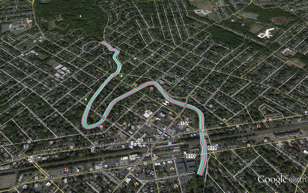
12
13 EXHIBIT B REQUIRED LER
14 RAHWAY RIVER BASIN, NEW JERSEY FLOOD RISK MANAGEMENT FEASIBILITY STUDY REQUIRED LER Temporary Work Area Easements Permanent Easements PAMS_PIN MUN BLOCK LOT Shape_Area PAMS_PIN MUN BLOCK LOT Shape_Area 2003_261_ _261_ _184_ _262_ _262_ _263_ _263_ _312_ _312_ _312_ _312_ _312_ _312_ _312_ _261_ _262_ _262_ _262_ _262_ _200_ _200_ _200_ _200_ _200_ _200_ _200_ _200_ _507_ _800_ _261_ _507_ _261_ _261_ _261_ _261_ _261_ _261_ _169_ _169_ _169_ _169_ _169_ _169_ _169_ _169_ _169_ _169_ _169_
15 2003_169_ _169_ _169_ _169_ _169_ _180_ _169_ _179_ _180_ _179_ _179_ _179_ _179_ _179_ _179_ _179_ _179_ _179_ _179_ _179_ _179_ _262_ _179_ _185_ _179_ _185_ _179_ _185_ _179_ _185_ _262_ _185_ _185_ _185_ _185_ _184_ _185_ _261_ _185_ _195_ _185_ _184_ _185_ _482_ _184_ _179_ _184_ _179_ _261_ _262_ _195_ _196_ _184_ _200_ _184_ _200_ _482_ _105_ _200_ _103_
16 2003_179_ _200_ _179_ _200_ _262_ _262_ _262_7_C02B _481_ _196_ _480_ _200_ _480_ _200_ _479_ _179_ _168_ _179_ _168_ _179_ _168_ _105_ _168_ _103_ _168_ _200_ _168_ _200_ _168_ _200_ _168_ _262_7_C05 G _168_ _262_ _169_ _481_ _169_ _480_ _200_ _480_ _200_ _479_ _200_ _168_ _185_ _168_ _184_ _168_ _184_ _168_ _184_ _168_ _184_ _168_ _186_ _168_ _186_ _168_ _186_
17 2003_168_ _184_ _169_ _184_ _169_ _184_ _200_ _184_ _200_ _312_ _200_ _312_ _200_ _312_ _185_ _312_ _184_ _313_ _184_ _262_ _184_ square ft. 2003_184_ acre 2003_186_ _186_ _186_ _186_ _186_ _184_ _184_ _184_ _184_ _312_ _312_ _312_ _312_ _312_ _312_ _313_ _262_
18 2003_262_7_C02C _262_7_C05F square ft acre
19 EXHIBIT C STANDARD ESTATES
20 Channel Improvement Easement (Standard Estate No. 8) A perpetual and assignable right and easement to construct, operate, and maintain channel improvement works on, over and across [Section, Block, and Lot] for the purposes as authorized by the Act of Congress approved in Section 401(a) of the Water Resources Development Act of 1986 (Public Law ), including the right to clear, cut, fell, remove and dispose of any and all timber, trees, underbrush, buildings, improvements and/or other obstructions therefrom; to excavate: dredge, cut away, and remove any or all of said land and to place thereon dredge or spoil material; and for such other purposes as may be required in connection with said work of improvement; reserving, however, to the owners, their heirs and assigns, all such rights and privileges as may be used without interfering with or abridging the rights and easement hereby acquired; subject, however, to existing easements far public roads and highways, public utilities, railroads and pipelines. Flood Protection Levee Easement (Standard Estate No. 9) A perpetual and assignable right and easement in (the land described in Schedule A) (Tracts Nos,, and ) to construct, maintain, repair, operate, patrol and replace a flood protection (levee) (floodwall)(gate closure) (sandbag closure), including all appurtenances thereto; reserving, however, to the owners, their heirs and assigns, all such rights and privileges in the land as may be used without interfering with or abridging the rights and easement hereby acquired; subject, however, to existing easements for public roads and highways, public utilities, railroads and pipelines. Temporary Work Area Easement (Standard Estate No. 15) A temporary easement and right-of-way in, on, over and across [Section, Block, and Lot] for a period not to exceed three (3) years, beginning with date possession of the land is granted to the United States, for use by the United States, its representatives, agents, and contractors as a work area, including the right to (borrow and/or deposit fill, spoil and waste material thereon) (move, store and remove equipment and supplies, and erect and remove temporary structures on the land and to perform any other work necessary and incident to the construction of the Rahway River Basin Flood Risk Management Project, together with the right to trim, cut, fell and remove therefrom all trees, underbrush, obstructions, and any other vegetation, structures, or obstacles within the limits of the right-of-way; reserving, however, to the landowners, their heirs and assigns, all such rights and privileges as may be used without interfering with or abridging the rights and easement hereby acquired; subject, however, to existing easements for public roads and highways, public utilities, railroads and pipelines. Right of Entry for Survey and Exploration (Standard Estate No. 20) An assignable easement, in, on, over and across the land described in Exhibit "A" for a period of ( ) months beginning with the date possession of the land is granted to the United States, consisting of the right of the United States, its representative, agents, contractors and assigns to enter upon said land to survey, stake out, appraise, make borings; and conduct tests and other exploratory work necessary to the design of a public works project; together with the
21 right to trim, cut, fell, and remove therefrom all trees, underbrush, obstructions, and any other vegetation, structures, or obstacles as required in connection with said work; subject to existing easements for public roads and highways, public utilities, railroads and pipelines; reserving, however, to the landowner(s), their heirs, executors, administrators, successors and assigns, all such right, title, interest and privilege as may be used and enjoyed without interfering with or abridging the rights and easement hereby acquired. Non-structural Floodproofing Agreement TRACT NO. [TRACT] RAHWAY FLUVIAL NONSTRUCTURAL FLOOD CONTROL PROJECT WHEREAS, pursuant to Public Law (Title II, Section 202, of the Energy and Water Development Appropriation Act, 1981), as amended, and pursuant to the provisions of the Project Partnership Agreement (hereinafter referred to as the "PPA") dated [DATE] between the United States of America (hereinafter sometimes referred to as the "Government") and the New Jersey Department of Environmental Project (hereinafter sometimes referred to as the "NJDEP"), NJDEP has undertaken the implementation of the Rahway Fluvial Nonstructural Flood Control Project (hereinafter sometimes referred to as the "Project"); WHEREAS, implementation of the Project includes, inter alia, the floodproofing of certain structures so that the habitable floors thereof are raised to levels or protected by other means in such a manner which will protect the structures from certain flooding to the greater extent practicable by allowing the free movement of floodwater beneath and around the structures; WHEREAS, pursuant to the PPA, the has undertaken floodproofing and acquisitions of interests in land for and on behalf of the County;
22 WHEREAS, [PROPERTY OWNER]; (hereinafter sometimes referred to as the "Owner"), is the Owners of a certain parcel of land identified by the NJDEP as Tract No. [TRACT], and being the same land as that described in a deed from [ACQURIING TRANSACTION DESCRIPTION], which existing structure can and shall be floodproofed in compliance with this agreement and; Project; WHEREAS, it is the desire of the Owner to participate in and receive the benefits of the NOW, THEREFORE, THIS AGREEMENT AND GRANT made and entered into by and between [OWNER]; and the NJDEP, as aforesaid; WITNESSETH, that for and in consideration of the premises and the mutual agreements and covenants hereinafter set forth; 1. The NJDEP, in conjunction with the Government, hereby agrees floodproof the subject structure through elevation of the structure. The Owner shall permit entry upon the property by an authorized Government contractor, and permit said contractor to modify the structure consistent with contractor design to be developed. The Owner shall further permit an inspection or inspections of the floodproofing work by the NJDEP, its contractors, assigns or representatives upon completion of the work, and/or at any time during the work's progress, to ensure that the work is acceptable to the NJDEP and has been satisfactorily performed to meet the Project's criteria as to design, construction, and protection. Provided, further, that the floodproofed structure shall
23 not be located within the regulatory floodway. Provided, further, that, should the Owner incur any cost in excess of said amount, that cost shall be borne by the Owner unless such additional amount is expressly approved in writing by the Government as necessary for the purposes of flood damage reduction. 3. The Owner hereby agrees that the Owner shall not convey to any third party any interest in and to said land and the structures or create any liens thereon prior to completion of said floodproofing work and recordation of this Agreement by the Government in the land records of Union County, New Jersey, without the prior written approval of the Government. 4. The Owner hereby acknowledges that the Government has made no warranties or guarantees whatsoever in connection with the Contractor or with the Contractor's ability to satisfactorily perform the work; and, that, as between the Government and the Owner, the Owner is solely responsible to arrange for the Contractor's satisfactory completion of the work in accordance herewith. 5. Further, that for and in the consideration aforesaid, the receipt and sufficiency of which are hereby acknowledged, the Owner, for herself and her heirs and assigns, do hereby GRANT, unto the NJDEP, and its assigns, the perpetual right, power, and privilege of access to said land and any structures thereon at all reasonable times considered necessary by the NJDEP, its contractors, assigns or representatives to ensure that this Agreement, its covenants and restrictions, and the intents and purposes of the project are being complied with by the Owner, for herself and her heirs and assigns.
24 6. The Owner, for herself and her heirs and assigns, hereby covenant and warrant to the NJDEP, and to its assigns forever, and agree, that no construction, alteration, or placement of structures of any kind or nature whatsoever on said land shall take place unless the lowest floor thereof to be used for human habitation, commercial or business purposes is elevated above [DETERMINED ELEVATION] feet mean sea level, and this restriction also prohibits the placement of water damageable material of any kind below the stated elevation of [DETERMINED ELEVATION] mean sea level, and any use of materials below this elevation must meet the requirement of Flood Resistant Material as defined in the Federal Emergency Management Agency s (FEMA) FIA-TB-2(4/93)(Technical Bulletin 2-93) this restriction and requirement shall be specifically included in every instrument subsequent hereto conveying title to any interest in said land or structures thereon. 7. The Owner, for herself and her heirs and assigns, hereby covenant, warrant, and agree she will forever hold and save harmless and blameless the Government and the NJDEP, and its assigns, from any damages or injuries resulting either directly or indirectly from any floodproofing work and any flooding of said land or of the floodproofed structure. 8. The Owner, for herself and her heirs and assigns, recognize and agree that the grant hereby made to the NJDEP, and the covenants and restrictions herein, in connection with the Leonardo Nonstructural Flood Control Project, are necessary and appropriate to ensure the purposes of said Project, namely, as authorized by Section 202 of the Water Resources and Development Act of 1981, Public Law , as amended, to afford a level of protection against flooding at least
25 sufficient to prevent any future losses from the likelihood of flooding as [LEVEL OF PROTECTION], whichever is greater; and, that for those purposes the NJDEP, and its assigns, shall forever have the right unchallenged by the Owner, and by the Owner s heirs and assigns, to seek legal enforcement of all of the provisions contained herein, it being the intentions of the parties that said provisions shall attach to and run with the land forever. 9. It is further provided that the obligations of the Government herein are contingent upon the Owner obtaining, as may be acceptable to the Government, the consent of any lienholder or tenants to the terms of this Agreement and obtaining from any lienholder or tenants waivers, releases, and/or subordinations of her rights in the premises to the extent necessary to accomplish the work and covenants and restrictions herein, as may be required by the Government.
26 IN WITNESS WHEREOF, the parties have executed this Agreement and Deed effective as of the date of acceptance hereof by the New Jersey Department of Environmental Protection. [OWNER NAME] Owner [OWNER NAME], Owner ACKNOWLEDGEMENT STATE OF COUNTY OF The foregoing instrument was acknowledged before me this day of, 2015, by [OWNER NAME] and [OWNER NAME]. NOTARY PUBLIC My Commission Expires: ACCEPTED: NEW JERSEY DEPARTMENT OF ENVIRONMENTAL PROJECTION By: [TITLE] DATE
27 ACKNOWLEDGEMENT STATE OF NEW JERSEY COUNTY OF UNION On this day of, [YEAR], the undersigned officer, personally appeared, [TITLE], New Jersey Department of Environmental Protection, known to me to be the person described in the foregoing Agreement and Deed, and acknowledged that he executed the same in the capacity therein stated and for the purposes therein contained. IN WITNESS WHEREOF, I hereunto set my hand and official seal. (Seal) NOTARY PUBLIC My Commission Expires: THIS INSTRUMENT WAS PREPARED BY: [NAME], Attorney [ADDRESS 1] [ADDRESS 2]
28 EXHIBIT D BASELINE COST ESTIMATE FOR REAL ESTATE
29 TOTAL PROJECT REAL ESTATE COSTS (Cost-Shared 50%- 50%) Non- Federal Federal Project Cost CRANFORD BRANCH (ALTERNATIVE 4A) Cost Summary: Incidental Costs (01A) $1,294,500 $534,598 $1,829,098 Real Estate Acquisition Costs (01B) $525,000 $0 $525,000 Subtotal: $1,819,500 $534,598 $2,354,098 20% Contingency, Less Land Payments (01B1) $258,900 $106,920 $365, LANDS AND DAMAGES $2,078,400 $641,518 $2,719,918 01A INCIDENTAL COSTS $1,294,500 $534,598 $1,829,098 01A1 Acquisition (Admin Costs) $150,000 $75,000 01A1 A By Government (Gov't) $75,000 01A1 B By Non-Federal Sponsor (NFS) $150,000 01A1 C By Gov't on behalf of NFS 01A2 Survey $56,500 $28,250 01A2 A By Gov't (In-house) 01A2 B By Gov't (Contract) 01A2 C By NFS $56,500 01A2 D By Gov't on behalf of NFS 01A2 E Review of NFS $28,250 01A3 Appraisal $452,000 $158,200 01A3 A By Gov't (In-house) 01A3 B By Gov't (Contract) 01A3 C By NFS $452,000 01A3 D By Gov't on behalf of NFS 01A3 E Review of NFS $158,200 01A4 Title Services $565,000 $56,500 01A4 A By Gov't (Contract) 01A4 B By NFS $565,000
30 01A4 C By Gov't on behalf of NFS 01A4 D Review of NFS $56,500 01A5 Other Professional Services $0 $0 01A5 A By the Gov't 01A5 B By the NFS 01A5 C By Gov't on behzlf of NFS 01A5 D Review of NFS 01A6 Closing Cost (4% of Land Payments-01C1) $21,000 $0 01A6 A By Gov't 01A6 B By NFS $21,000 01A6 C By Gov't on behalf of NFS 01A7 PL Assistance $50,000 $25,000 01A7 A By Government 01A7 B By NFS $50,000 01A7 C By Gov't on behalf of NFS 01A7 D Review of NFS $25,000 01A8 Audit $0 $191,648 01A8 A By Gov't $191,648 01A9 B By NFS 01B REAL ESTATE ACQUISITION COSTS $525,000 $0 $525,000 01B1 Land Payments $525,000 $0 01B1 A By Government 01B1 B By NFS $525,000 01B1 C By Gov't on behalf of NFS 01B2 Damage Payments $0 $0 01B2 A By Government
31 01C2 B 01C2 C By NFS By Gov't on behalf of NFS 01B3 PL Payment $0 $0 01B3 A By Government 01B3 B By NFS $0 01B3 C By Gov't on behalf of NFS 01B4 Condemnation $0 $0 01B4 A By NFS $0 01B5 Facility / Utility Relocations $0 $0 01B5 A By NFS 01B6 Disposals $0 $0 01B6 A By Government 01B6 B By NFS 01B6 C By Gov't on behalf of NFS 01C LERRD CREDITING $1,039,20 0 TOTAL PROJECT REAL ESTATE COSTS (Cost-Shared 50%-50%) ROBINSON'S BRANCH NON- STRUCTURAL 10 YEAR Cost Summary: Non- Federal $292,70 0 Feder al $111, 866 Project Cost $404,56 6 Incidental Costs (01A) Real Estate Acquisition Costs (01B) $0 $0 $0 Subtotal: $292,70 0 $111, 866 $404, % Contingency $58,540 $22,3 73 $80, LANDS AND DAMAGES $351,24 0 $134, 239 $485,47 9
32 01A INCIDENTAL COSTS $292,70 0 $111, 866 $404, A1 01A1A 01A1B 01A1C Acquisition (Admin Costs) By Government (Gov't) By Non-Federal Sponsor (NFS) By Gov't on behalf of NFS $150,00 0 $150,00 0 $75,0 00 $75, A2 Survey $10,500 01A2A By Gov't (In-house) 01A2B By Gov't (Contract) 01A2C By NFS $10,500 01A2D By Gov't on behalf of NFS 01A2E Review of NFS $1,25 0 $1, A3 Appraisal $0 $0 01A3A By Gov't (In-house) 01A3B By Gov't (Contract) 01A3C By NFS $0 01A3D By Gov't on behalf of NFS 01A3E Review of NFS $0 01A4 Title Services $0 $0 01A4A By Gov't (Contract) 01A4B By NFS $0 01A4C By Gov't on behalf of NFS 01A4D Review of NFS $0 01A5 Other Professional Services $25,200 01A5A By the Gov't 01A5B By the NFS $25,200 01A5C By Gov't on behzlf of NFS 01A5D Review of NFS $12,6 00 $12, A6 Closing Cost (4% of Land Payments-01C1) $0 $0 01A6A By Gov't 01A6B By NFS $0 01A6C By Gov't on behalf of NFS 01A7 01A7A PL Assistance By Government $107,00 0 $0
33 01A7B By NFS $107, A7C By Gov't on behalf of NFS 01A7D Review of NFS $0 01A8 Audit $0 01A8A By Gov't 01A9B By NFS $35,6 16 $35, B REAL ESTATE ACQUISITION COSTS $0 $0 $0 01B1 Land Payments $0 $0 01B1A By Government 01B1B By NFS $0 01B1C By Gov't on behalf of NFS 01B2 Damage Payments $0 $0 01B2A By Government 01C2B By NFS 01C2C By Gov't on behalf of NFS 01B3 PL Payment $0 $0 01B3A By Government 01B3B By NFS $0 01B3C By Gov't on behalf of NFS 01B4 Condemnation $0 $0 01B4A By NFS $0 01B5 Facility / Utility Relocations $0 $0 01B5A By NFS 01B6 Disposals $0 $0 01B6A By Government 01B6B By NFS 01B6C By Gov't on behalf of NFS 01C LERRD CREDITING $175, 620
34 EXHIBIT E NON-FEDERAL SPONSOR CAPABILITY ASSESSMENT CHECKLIST
35 I. Legal Authority. ASSESSMENT OF NON-FEDERAL PROJECT PARTNERS S REAL ESTATE ACQUISITION CAPABILITY RAHWAY RIVER BASIN, NEW JERSEY FLOOD RISK MANAGEMENT FEASIBILITY STUDY a. Does the sponsor have legal authority to acquire and hold title to real property for project purposes? Yes. b. Does the sponsor have the power of eminent domain for this project? Yes. c. Does the sponsor have quick-take authority for this project? Yes. d. Are any of the lands/interests in land required for the project located outside the sponsor s political boundary? No. e. Are any of the lands/interests in land required for the project owned by an entity whose property the sponsor cannot condemn? No. II. Human Resource Requirements. a. Will the sponsor s in-house staff require training to become familiar with the real estate requirements of Federal projects including P.L , as amended? No. b. If the answer to II.a is yes, has a reasonable plan been developed to provide such training? c. Does the sponsor s in-house staff have sufficient real estate acquisition experience to meet its responsibilities for the project? Yes. d. Is the sponsor s projected in-house staffing level sufficient considering its other workload, if any, and the project schedule? Yes. e. Can the sponsor obtain contractor support, if required in a timely fashion? Yes. f. Will the sponsor likely request USACE assistance in acquiring real estate? No. III. Other Project Variables. a. Will the sponsor s staff be located within reasonable proximity to the project site? Yes. b. Has the sponsor approved the project/real estate schedule/milestones? Yes.
36 IV. Overall Assessment. a. Has the sponsor performed satisfactorily on other USACE projects? Yes. b. With regard to this project, the sponsor is anticipated to be: highly capable/fully capable/moderately capable/marginally capable/insufficiently capable. If sponsor is believed to be insufficiently capable, provide explanation. Highly Capable. V. Coordination. a. Has this assessment been coordinated with the sponsor? Yes. b. Does the sponsor concur with this assessment? Sponsor has not responded to this form. Reviewed and approved by: Noreen Dean Dresser Chief of Real Estate Division Real Estate Contracting Officer New York District Corps of Engineers
Appendix D: Real Estate
 Shrewsbury River Basin, Sea Bright, New Jersey Coastal Storm Risk Management Feasibility Study Draft Integrated Feasibility Report & Environmental Assessment Appendix D: Real Estate Shrewsbury River Basin,
JANUARY 2016 MAMARONECK & SHELDRAKE RIVERS NEW YORK FLOOD RISK MANAGEMENT GENERAL REEVALUATION REPORT FOR THE VILLAGE OF MAMARONECK APPENDIX E
 U.S. Army Corps of Engineers New York District MAMARONECK & SHELDRAKE RIVERS NEW YORK FLOOD RISK MANAGEMENT GENERAL REEVALUATION REPORT FOR THE VILLAGE OF MAMARONECK JANUARY 2016 APPENDIX E REAL ESTATE
CENAN-RE 22 May MEMORANDUM FOR Chief, Planning Division, ATTN: CENAN-PL-F (Alek Petersen)
") CENAN-RE 22 May 2017 MEMORANDUM FOR Chief, Planning Division, ATTN: CENAN-PL-F (Alek Petersen) SUBJECT: May 2017 Real Estate Plan for the Rahway River (Tidal) Basin, Coastal Storm Risk Management Feasibility
CENAN-RE 22 May 2017 MEMORANDUM FOR Chief, Planning Division, ATTN: CENAN-PL-F (Alek Petersen) SUBJECT: May 2017 Real Estate Plan for the Rahway River (Tidal) Basin, Coastal Storm Risk Management Feasibility
Appendix B Real Estate Plan
 Appendix B Real Estate Plan B-1 REAL ESTATE PLAN Prepared for U.S. Army Corps of Engineers Southwestern Division Little Rock District As of May 1, 2013 Prepared by Ronald Bridges Real Estate Division ANY
Appendix B Draft Real Estate Plan
 Appendix B Draft Real Estate Plan B-1 REAL ESTATE PLAN Prepared for U.S. Army Corps of Engineers Southwestern Division Little Rock District As of December 3, 2012 Prepared by Ronald Bridges Real Estate
HASHAMOMUCK COVE, SOUTHOLD, NEW YORK COASTAL STORM RISK MANAGEMENT FEASIBILITY STUDY APPENDIX F REAL ESTATE PLAN
 U.S. Army Corps of Engineers New York District HASHAMOMUCK COVE, SOUTHOLD, NEW YORK COASTAL STORM RISK MANAGEMENT FEASIBILITY STUDY APPENDIX F REAL ESTATE PLAN AUGUST 2016 HASHAMOMUCK COVE, SOUTHOLD, NEW
DRAFT INTEGRATED FEASIBILITY REPORT AND ENVIRONMENTAL ASSESSMENT
 APPENDIX E REAL ESTATE PLAN MT. SINAI MEDICAL CENTER, CONTINUTING AUTHORITIES PROGRAM (CAP) SECTION 14, PROJECT DRAFT INTEGRATED FEASIBILITY REPORT AND ENVIRONMENTAL ASSESSMENT September 2016 DRAFT APPENDIX
Appendix G. Non-Federal Letters of Support and Draft Real Estate Plan
 Appendix G Non-Federal Letters of Support and Draft Real Estate Plan REAL ESTATE PLAN UPPER DELAWARE RIVER WATERSHED FEASABILITY STUDY LIVINGSTON MANOR, NEW YORK 1. GENERAL 2. REAL ESTATE REQUIREMENTS
MAMARONECK AND SHELDRAKE RIVER FLOOD DAMAGE REDUCTION PROJECT MAMARONECK, NEW YORK APPENDIX E REAL ESTATE PLAN
 U.S. Army Corps of Engineers New York District MAMARONECK AND SHELDRAKE RIVER FLOOD DAMAGE REDUCTION PROJECT MAMARONECK, NEW YORK APPENDIX E REAL ESTATE PLAN April 2017 MAMARONECK AND SHELDRAKE RIVER FLOOD
Draft Continuing Authorities Program Section 1135 Detailed Project Report and Integrated Environmental Assessment
 Appendix G Real Estate Shorty s Island / Meander Reach Ecosystem Restoration Kootenai River, Idaho Draft Continuing Authorities Program Section 1135 Detailed Project Report and Integrated Environmental
EDISTO BEACH COASTAL STORM DAMAGE REDUCTION GENERAL INVESTIGATION STUDY APPENDIX K REAL ESTATE
 EDISTO BEACH COASTAL STORM DAMAGE REDUCTION GENERAL INVESTIGATION STUDY APPENDIX K REAL ESTATE Table of Contents REAL ESTATE APPENDIX... I... i SECTION 1. THE REAL ESTATE REPORT... 1 1.1 Statement of Purpose...
Appendix H: Real Estate Plan
 APPENDIX H Spring Creek North Ecosystem Restoration Feasibility Study Appendix H: Real Estate Plan New York District U.S. Army Corps of Engineers October 2016 Revised: 13 April 2017 Spring Creek North
Delaware River Basin Comprehensive Flood Risk Management Interim Feasibility Study and Integrated Environmental Assessment for New Jersey
 Delaware River Basin Comprehensive Flood Risk Management Interim Feasibility Study and Integrated Environmental Assessment for New Jersey Flooding in the Study Area, April 2005 June 2015 APPENDIX F: Draft
Appendix C. Real Estate. Brazos Island Harbor, Texas Channel Improvement Project Cameron County, Texas
 Appendix C Real Estate Brazos Island Harbor, Texas Channel Improvement Project Cameron County, Texas U.S. Army Corps of Engineers, Galveston District 2000 Fort Point Road Galveston, Texas 77550 December
APPENDIX M. Real Estate Plan
 APPENDIX M Real Estate Plan Poplar Island Environmental Restoration Project September 2005 General Reevaluation Report (GRR) and Supplemental Environmental Impact Statement (SEIS) REAL ESTATE PLAN (REP)
WEST SHORE LAKE PONTCHARTRAIN HURRICANE AND STORM DAMAGE RISK REDUCTION STUDY INTEGRATED DRAFT FEASIBILITY REPORT AND ENVIRONMENTAL IMPACT STATEMENT
 WEST SHORE LAKE PONTCHARTRAIN HURRICANE AND STORM DAMAGE RISK REDUCTION STUDY INTEGRATED DRAFT FEASIBILITY REPORT AND ENVIRONMENTAL IMPACT STATEMENT REAL ESTATE PLAN APPENDIX C Annex A: Project Maps Annex
INDIANA HARBOR AND CANAL CONFINED DISPOSAL FACILITY EAST CHICAGO, INDIANA
 INDIANA HARBOR AND CANAL CONFINED DISPOSAL FACILITY EAST CHICAGO, INDIANA APPENDIX J REAL ESTATE Acquisition Branch Real Estate Division Chicago District U.S. Army Corps of Engineers APPENDIX J REAL ESTATE
DRAFT East Rockaway Inlet to Rockaway Inlet and Jamaica Bay. Atlantic Coast of New York
 DRAFT East Rockaway Inlet to Rockaway Inlet and Jamaica Bay Atlantic Coast of New York APPENDIX E REAL ESTATE PLAN AUGUST 2018 East Rockaway Inlet to Rockaway Inlet and Jamaica Bay Reformulation Study
Draft Integrated Feasibility Report and Environmental Assessment and Draft Finding of No Significant Impact
 Draft Integrated Feasibility Report and Environmental Assessment and Draft Finding of No Significant Impact APPENDIX F: REAL ESTATE Whittier, Alaska June 2018 Pacific Ocean Division DRAFT REAL ESTATE
BEACH STORM DAMAGE REDUCTION EASEMENT
 STATE OF FLORIDA COUNTY OF WALTON WALTON COUNTY, FL HURRICANE & STORM DAMAGE REDUCTION PROJECT FILE/REACH#: PARCEL ID#: BEACH STORM DAMAGE REDUCTION EASEMENT KNOW ALL MEN BY THESE PRESENTS, that for and
APPENDIX D - REAL ESTATE
 APPENDIX D - REAL ESTATE 1. Purpose Real Estate Plan For Feasibility Study For Lake Lou Yaeger Section 206 Aquatic Ecosystem Restoration Continuing Authorities Project Feasibility Study This report is
REAL ESTATE PLAN APPENDIX G
 Pacific Ocean Division REAL ESTATE PLAN APPENDIX G Alaska District UNALASKA (DUTCH HARBOR) CHANNELS UNALASKA, ALASKA Real Estate Division Alaska District U.S. Army Corps of Engineers TABLE OF CONTENTS
AGREEMENT TO ACQUIRE LANDS BETWEEN THE DEPARTMENT OF THE ARMY ST. PAUL DISTRICT, CORPS OF ENGINEERS AND. THE CITY OF City, State
 AGREEMENT TO ACQUIRE LANDS BETWEEN THE DEPARTMENT OF THE ARMY ST. PAUL DISTRICT, CORPS OF ENGINEERS AND THE CITY OF City, State FOR CONDEMNATION ON BEHALF OF THE SPONSOR BY THE CORPS OF ENGINEERS FOR THE
APPENDIX F REAL ESTATE
 APPENDIX F REAL ESTATE Real Estate Plan For Broward County, Florida Shore Protection Project Segments II and III General Reevaluation Report 1. Statement Of Purpose. The Real Estate Plan is tentative in
Appendix K. Real Estate Plan
 Appendix K. Real Estate Plan REAL ESTATE PLAN DELTA ISLANDS AND LEVEES FEASIBILITY STUDY (DELTA STUDY) 20 June 2018 PREPARED BY THE SACRAMENTO DISTRICT U.S. ARMY CORPS OF ENGINEERS 1 TABLE OF CONTENTS
Draft Environmental Impact Statement (EIS)/Environmental Impact Report (EIR) APPENDIX H Real Estate Cost
/Environmental Impact Report (EIR) APPENDIX H Real Estate Cost") Draft Environmental Impact Statement (EIS)/Environmental Impact Report (EIR) APPENDIX H Real Estate Cost US Army Corps of Engineers Corte Madera Creek Flood Risk Management Project October 2018 APPENDIX
Draft Environmental Impact Statement (EIS)/Environmental Impact Report (EIR) APPENDIX H Real Estate Cost US Army Corps of Engineers Corte Madera Creek Flood Risk Management Project October 2018 APPENDIX
APPENDIX E REAL ESTATE PLAN
 APPENDIX E REAL ESTATE PLAN REAL ESTATE PLAN VILLAGE OF BARBOURSVILLE, WATER STREET, STREAMBANK PROTECTION PROJECT CABELL COUNTY, WEST VIRGINIA SECTION 14 1. Authority/Purpose This Real Estate Plan is
APPENDIX H. Real Estate Plan
 INTEGRATED FEASIBILITY REPORT AND ENVIRONMENTAL IMPACT STATEMENT COASTAL STORM DAMAGE REDUCTION BOGUE BANKS, CARTERET COUNTY NORTH CAROLINA APPENDIX H Real Estate Plan US Army Corps of Engineers Wilmington
APPENDIX G REAL ESTATE
 BUBBLY CREEK, SOUTH BRANCH OF THE CHICAGO RIVER, ILLINOIS FEASIBILITY STUDY APPENDIX G REAL ESTATE DRAFT - NOT FOR DISTRIBUTION APRIL 2015 U.S. Army Corps of Engineers Chicago District Appendix G Real
City of East Providence
 City of East Providence 145 TAUNTON AVENUE, EAST PROVIDENCE STATE OF RHODE ISLAND AND PROVIDENCE PLANTATIONS 02914-4505 TEL. (401) 435-7521 FAX (401) 438-1719 TDD (401) 431-1633 CITY MANAGER PETER GRACZYKOWSKI
Skagit River Flood Risk Management General Investigation Skagit County, Washington. Draft Feasibility Report and Environmental Impact Statement
 General Investigation Skagit County, Washington Draft Feasibility Report and Environmental Impact Statement May 2014 Real Estate Requirements of Selected Plan This Real Estate Plan Summary (REP) is presented
ESCROW AGREEMENT - MAINTENANCE
 ESCROW AGREEMENT - MAINTENANCE This ESCROW AGREEMENT (the Agreement ) is made and entered into this day of,, by and between the City of O Fallon, Missouri, a Missouri municipal corporation (hereinafter
Dredged Material Management Plan Atlantic Intracoastal Waterway Port Royal Sound, South Carolina to Cumberland Sound, Georgia November 2015
 Dredged Material Management Plan Atlantic Intracoastal Waterway Port Royal Sound, South Carolina to Cumberland Sound, Georgia November 2015 Appendix H: Real Estate US Army Corps of Engineers South Atlantic
CHAPTER 2 RELATED DOCUMENTS AND FORMS
 CHAPTER 2 RELATED DOCUMENTS AND FORMS TABLE OF CONTENTS CHAPTER 2 RELATED DOCUMENTS AND FORMS Resolution R00- Establishing Public Improvement Design Standards Page 1 Current Plans Review & Construction
HUNTING BAYOU FLOOD RISK MANAGEMENT, HARRIS COUNTY, TEXAS DRAFT GENERAL REEVALUATION REPORT AND INTEGRATED ENVIRONMENTAL ASSESSMENT
 HUNTING BAYOU FLOOD RISK MANAGEMENT, HARRIS COUNTY, TEXAS DRAFT GENERAL REEVALUATION REPORT AND INTEGRATED ENVIRONMENTAL ASSESSMENT APPENDIX 6 REAL ESTATE PLAN June 2014 HARRIS COUNTY FLOOD CONTROL DISTRICT
CITY AND COUNTY OF BROOMFIELD SUBDIVISION IMPROVEMENT AGREEMENT FOR (PROPERTY NAME - ALL CAPS)
") CITY AND COUNTY OF BROOMFIELD SUBDIVISION IMPROVEMENT AGREEMENT FOR (PROPERTY NAME - ALL CAPS) THIS AGREEMENT, made and entered into this day of, 20, by and between The CITY AND COUNTY OF BROOMFIELD, a
CITY AND COUNTY OF BROOMFIELD SUBDIVISION IMPROVEMENT AGREEMENT FOR (PROPERTY NAME - ALL CAPS) THIS AGREEMENT, made and entered into this day of, 20, by and between The CITY AND COUNTY OF BROOMFIELD, a
APPENDIX C REAL ESTATE PLAN BOULEVARD RESACA, BROWNSVILLE, TX CAMERON COUNTY, TEXAS
 APPENDIX C REAL ESTATE PLAN BOULEVARD RESACA, BROWNSVILLE, TX CAMERON COUNTY, TEXAS November 19, 2016 Table of Contents Purpose... 3 Project Authority... 3 Project Location and Description... 3 Non-Federal
It is necessary for the Board to adopt the attached resolution accepting the dedication of the easement.
 SOUTHAMPTON COUNTY BOARD OF SUPERVISORS Regular Session i May 28, 2013 11. ACCEPTANCE OF A SANITARY SEWER EASEMENT FROM THE COMMONWEALTH OF VIRGINIA, DEPARTMENT OF TRANSPORTATION Attached for your review
Final General Reevaluation Report and Final Environmental Impact Statement. Hurricane Protection and Beach Erosion Control
 Final General Reevaluation Report and Final Environmental Impact Statement on Hurricane Protection and Beach Erosion Control WEST ONSLOW BEACH AND NEW RIVER INLET (TOPSAIL BEACH), NORTH CAROLINA Appendix
Downtown Montauk Stabilization Project. Real Estate Plan Appendix
 Downtown Montauk Stabilization Project Real Estate Plan Appendix October 2014 Table of Contents Page 1. Introduction and General Information 1 a. Authority 2 b. History 2 c. Location Project Study Area
STORMWATER BEST MANAGEMENT PRACTICES OPERATIONS AND MAINTENANCE AGREEMENT
 STORMWATER BEST MANAGEMENT PRACTICES OPERATIONS AND MAINTENANCE AGREEMENT THIS AGREEMENT, made and entered into this day of, 20, by and between, (hereinafter the Landowner ), and the TOWNSHIP OF HEMPFIELD,
(Space above this line reserved for Recorder of Deeds)
") (Space above this line reserved for Recorder of Deeds) STORMWATER MANAGEMENT and BEST MANAGEMENT PRACTICES FACILITIES MAINTENANCE AGREEMENT COVER PAGE Date: Grantor: Grantee: Property Owner Owner's Address
(Space above this line reserved for Recorder of Deeds) STORMWATER MANAGEMENT and BEST MANAGEMENT PRACTICES FACILITIES MAINTENANCE AGREEMENT COVER PAGE Date: Grantor: Grantee: Property Owner Owner's Address
REGULATORY AND RESTRICTIVE COVENANTS FOR LAND USE AGREEMENT
 LIHTCP-8 WVHDF (7/14/05) REGULATORY AND RESTRICTIVE COVENANTS FOR LAND USE AGREEMENT Low-Income Housing Tax Credit Program West Virginia Housing Development Fund APPENDIX F THIS REGULATORY AND RESTRICTIVE
PURCHASE AGREEMENT. 4. CONTINGENCIES. This Purchase Agreement is contingent upon the satisfaction of the following conditions:
 PURCHASE AGREEMENT 1. PARTIES. This purchase agreement (the Purchase Agreement ) is made this day of, 2017, by and between the County of Carver, Minnesota, a public body politic and corporate having the
UPPER MISSISSIPPI RIVER RESTORATION FEASIBILITY REPORT WITH INTEGRATED ENVIRONMENTAL ASSESSMENT
 UPPER MISSISSIPPI RIVER RESTORATION FEASIBILITY REPORT WITH INTEGRATED ENVIRONMENTAL ASSESSMENT McGregor Lake HABITAT REHABILITATION AND ENHANCEMENT PROJECT POOL 10, UPPER MISSISSIPPI RIVER MILE 635-634
ORDINANCE NO
 Draft No. 12-21 ORDINANCE NO. 2012-23 AN ORDINANCE ACCEPTING A RIGHT-OF-WAY AND UTILITY EASEMENT FOR WATER LINES, SEWER LINES, STORM SEWER LINES AND SUCH OTHER UTILITIES AS ARE NEEDED FROM THE CARTER JONES
APPENDIX H REAL ESTATE REQUIREMENTS
 Malden River Ecosystem Restoration Detailed Project Report APPENDIX H REAL ESTATE REQUIREMENTS April 2007 Malden River Ecosystem Restoration Real Estate Report 1. PURPOSE: The Detailed Project Report
Stormwater Treatment Facility Maintenance Agreement
 Stormwater Treatment Facility Maintenance Agreement This Agreement made and entered into this day of, 20, by, (hereinafter referred to as Property Owner") RECITALS: WHEREAS, the Property Owner is the owner
DRAFT REAL ESTATE PLAN APPENDIX D JEFFERSON COUNTY ECOSYSTEM RESTORATION FEASIBILITY STUDY
 DRAFT REAL ESTATE PLAN APPENDIX D JEFFERSON COUNTY ECOSYSTEM RESTORATION FEASIBILITY STUDY (NOTE: This page intentionally left blank.) This Real Estate Plan has been prepared in accordance with ER 405-1-12
1 West Main Street -- Box 1, Fincastle, Virginia STORMWATER MANAGEMENT INFRASTRUCTURE MAINTENANCE AGREEMENT
 1 West Main Street -- Box 1, Fincastle, Virginia 24090 STORMWATER MANAGEMENT INFRASTRUCTURE MAINTENANCE AGREEMENT THIS AGREEMENT, made and entered into this day of, 20, by and between (Insert Full Name
50-Foot Non-Exclusive EASEMENT AGREEMENT
 50-Foot Non-Exclusive EASEMENT AGREEMENT THIS EASEMENT AGREEMENT is dated this day of _, 20, by Parker Task Force For Human Services (hereafter referred to as "Grantor"), having an address at 20118 East
SMOKY LAKE COUNTY. Alberta Provincial Statutes
 SMOKY LAKE COUNTY Title: Disposition of County Owned Property Policy No: 10-01 Section: 61 Code: P-R Page No.: 1 of 14 E Legislative Reference: Alberta Provincial Statutes Purpose: To outline the procedures
PIPELINE RIGHT-OF-WAY EASEMENT
 PIPELINE RIGHT-OF-WAY EASEMENT THIS RIGHT-OF-WAY EASEMENT made this day of March, 2014, by the City of Rochester Hills, a municipal corporation in the State of Michigan,, having an address at 1000 Rochester
TOWNSHIP OF LOWER MERION Department of Public Works
 EXHIBIT B TOWNSHIP OF LOWER MERION Department of Public Works MEMORANDUM TO: Douglas S. Cleland, Township Manager FROM: Donald K. Cannon, Director of Public Works SUBJECT: 1200 Farview Road Sanitary Sewer
PURCHASE AND SALE AGREEMENT
 PURCHASE AND SALE AGREEMENT This Purchase and Sale Agreement (this Agreement ) made and entered into as of the day of, 2017 (the Effective Date ), by and between the Greenville County Library System (the
This is a sample form for information ONLY. UTILITY INFRASTRUCTURE CONVEYANCE AND SERVICE AGREEMENT
 This is a sample form for information ONLY. A CSA will be tailored to your project at the appropriate time during the development process. Please contact the Development Services Team for additional information.
Municipality of Anchorage PURCHASE AND SALE AGREEMENT FOR LOT 17, NEVILLA PARK SUBDIVISION
 Municipality of Anchorage PURCHASE AND SALE AGREEMENT FOR LOT 17, NEVILLA PARK SUBDIVISION THIS AGREEMENT dated, 2016, by and between the MUNICIPALITY OF ANCHORAGE, an Alaska municipal corporation, whose
SITE LEASE. between. CITY OF WESTWOOD, KANSAS, as Site Lessor. and. SECURITY BANK OF KANSAS CITY, as Site Lessee
 Gilmore & Bell, P.C. Draft #2 March 7, 2014 SITE LEASE between CITY OF WESTWOOD, KANSAS, as Site Lessor and SECURITY BANK OF KANSAS CITY, as Site Lessee After Recording, return to: Nancy Midden Gilmore
EASEMENT AGREEMENT (Distributor Performance Non-Exclusive)
") EASEMENT AGREEMENT (Distributor Performance Non-Exclusive) THIS EASEMENT AGREEMENT, effective the day of, 20, is made between WITNESSETH:, hereafter called Grantor, (whether grammatically singular or plural)
EASEMENT AGREEMENT (Distributor Performance Non-Exclusive) THIS EASEMENT AGREEMENT, effective the day of, 20, is made between WITNESSETH:, hereafter called Grantor, (whether grammatically singular or plural)
DEED AND DEDICATION FOR PUBLIC RIGHT OF WAY
 TO : BOARD OF DIRECTORS FROM : GARY PLATT, EXEC. DIRECTOR BUSINESS AND OPERATIONS SUBJECT : CITY OF STANWOOD CONSTRUCTION EASEMENT AND RIGHT-OF-WAY DEDICATION DATE : MARCH 17, 2009 TYPE : ACTION NEEDED
DECLARATION OF DRAINAGE EASEMENTS. Document No. Document Title. (Declarant) Recording Data Return Address
 Recording Data Return Address") Document No. DECLARATION OF DRAINAGE EASEMENTS Document Title (Declarant) Recording Data Return Address DOCUMENT PREPARED BY AND AFTER RECORDING RETURN TO: Parcel No. - - - - - - DECLARATION OF DRAINAGE
Document No. DECLARATION OF DRAINAGE EASEMENTS Document Title (Declarant) Recording Data Return Address DOCUMENT PREPARED BY AND AFTER RECORDING RETURN TO: Parcel No. - - - - - - DECLARATION OF DRAINAGE
BOONE COUNTY, MISSOURI RESOURCE MANAGEMENT DEPARTMENT (573)
") STORMWATER MANAGEMENT/BMP FACILITIES MAINTENANCE AGREEMENT FOR ON-SITE FACILITIES BOONE COUNTY, MISSOURI RESOURCE MANAGEMENT DEPARTMENT (573)-886-4330 THIS agreement made and entered into this Day of 20,
STORMWATER MANAGEMENT/BMP FACILITIES MAINTENANCE AGREEMENT FOR ON-SITE FACILITIES BOONE COUNTY, MISSOURI RESOURCE MANAGEMENT DEPARTMENT (573)-886-4330 THIS agreement made and entered into this Day of 20,
Appendix J. Real Estate Plan
 Appendix J Real Estate Plan Real Estate Plan Louisiana Coastal Area Near-Term Ecosystem Restoration Plan Medium Diversion at White Ditch 1. PURPOSE Title VII of the Water Resources Development Act of 2007
Municipality of Anchorage PURCHASE AND SALE AGREEMENT FOR HLB Parcel C in Chugiak, Alaska
 Municipality of Anchorage PURCHASE AND SALE AGREEMENT FOR HLB Parcel 1-007-C in Chugiak, Alaska THIS AGREEMENT dated, 2017, by and between the MUNICIPALITY OF ANCHORAGE, an Alaska municipal corporation,
NORTH CAROLINA DEED OF TRUST NORTH CAROLINA HOUSING FINANCE AGENCY $15,000 DPA Program Only
 NORTH CAROLINA DEED OF TRUST NORTH CAROLINA HOUSING FINANCE AGENCY $15,000 DPA Program Only After recording, return the executed document back to the Originating Lender (not NCHFA) within 24 hours of closing.
UTILITY EASEMENT AGREEMENT
 THIS INSTRUMENT PREPARED BY AND RETURN TO: Roy K. Payne, Esq. Chief Assistant City Attorney 400 S. Orange Avenue Orlando, FL 32801 Roy.Payne@CityofOrlando.Net UTILITY EASEMENT AGREEMENT THIS UTILITY EASEMENT
APPENDIX L NONSTRUCTURAL IMPLEMENTATION PLAN
 NONSTRUCTURAL IMPLEMENTATION PLAN Table of Contents A. DEFINITIONS... 3 B. INTRODUCTION... 4 C. ELEVATION OF ELIGIBLE RESIDENTIAL STRUCTURES... 5 1. DETERMINING ELIGIBILITY: 2 STEP ELIGIBILITY PROCESS...
VOLUNTARY SALES ASSISTANCE PROGRAM CONSISTING OF TWO OPTIONS:
 VOLUNTARY SALES ASSISTANCE PROGRAM CONSISTING OF TWO OPTIONS: STANDARD SALES ASSISTANCE PROGRAM & CONVEYANCE AND RELEASE PROGRAM POLICIES AND PROCEDURES MANUAL Broward County Aviation Department Fort Lauderdale
REAL ESTATE PLAN. Final Integrated General Reevaluation Report and Supplemental Environmental Impact Statement
 REAL ESTATE PLAN Final Integrated General Reevaluation Report and Supplemental Environmental Impact Statement Mississippi River, Baton Rouge to the Gulf of Mexico Mississippi River-Gulf Outlet, Louisiana,
Southwest Coastal Louisiana Study
 REAL ESTATE PLAN Annex 1: Project Maps Annex 2: Assessment of Non-Federal Sponsor s Acquisition Capability Annex 3: Non-Material Deviation from Standard Estate Perpetual Access Easement Annex 4: Baseline
WATER LINE & INGRESS/EGRESS EASEMENT AGREEMENT WITNESSETH:
 Prepared by and return to: Carie E. Shealy, MMC, City Clerk City of Cocoa 65 Stone Street Cocoa, Florida 32922 Parcel ID. #(s): WATER LINE & INGRESS/EGRESS EASEMENT AGREEMENT THIS EASEMENT AGREEMENT is
DECLARATION OF RESTRICTIVE COVENANTS. THIS DECLARATION OF RESTRICTIVE COVENANTS made this day of, 200_, by ( Declarant ). RECITALS
. RECITALS") DECLARATION OF RESTRICTIVE COVENANTS THIS DECLARATION OF RESTRICTIVE COVENANTS made this day of, 200_, by ( Declarant ). RECITALS WHEREAS, Declarant is the owner of the surface of certain real property
DECLARATION OF RESTRICTIVE COVENANTS THIS DECLARATION OF RESTRICTIVE COVENANTS made this day of, 200_, by ( Declarant ). RECITALS WHEREAS, Declarant is the owner of the surface of certain real property
COMMERCIAL PROPERTY ASSESSED CLEAN ENERGY ( C-PACE ) AGREEMENT
 AGREEMENT") COMMERCIAL PROPERTY ASSESSED CLEAN ENERGY ( C-PACE ) AGREEMENT THIS AGREEMENT is made and entered into as of the day of, 2015, by and between [TOWN NAME], CONNECTICUT, a municipal corporation organized
COMMERCIAL PROPERTY ASSESSED CLEAN ENERGY ( C-PACE ) AGREEMENT THIS AGREEMENT is made and entered into as of the day of, 2015, by and between [TOWN NAME], CONNECTICUT, a municipal corporation organized
PERMANENT DRAINAGE EASEMENT
 City Project No. Project Name: ; Tr. # Parcel No. (LLC, Corporation, Partnership) PERMANENT DRAINAGE EASEMENT THIS AGREEMENT, made and entered into this day of, 201, by and between, a, hereinafter called
Appendix D Real Estate Plan
 Appendix D Real Estate Plan Matagorda Ship Channel, Port Lavaca, Texas Feasibility Report and Environmental Impact Statement, Review of Completed Projects, Calhoun and Matagorda Counties May 2018 (NOTE:
Storm Water Management BMP Maintenance Agreement City of St. George, Utah
 RECORDED, MAIL TO: St. George City 175 East 200 North St. George, UT 84770 Tax ID: BMP Maintenance Agreement City of St. George, Utah WHEREAS, the Property Owner recognizes that the post construction storm
PURCHASE AGREEMENT ACCORDINGLY, FOR VALUABLE CONSIDERATION, RECEIPT OF WHICH IS HEREBY ACKNOWLEDGED, THE PARTIES AGREE AS FOLLOWS:
 PURCHASE AGREEMENT JOHN THOMAS BUILDING, 325 EAST 3 RD AVENUE, ANCHORAGE AK THIS AGREEMENT dated, 2013, by and between the MUNICIPALITY OF ANCHORAGE, an Alaska municipal corporation, whose mailing address
For Sale SEALED BID SALE. Sale No. GSA-R Former Missile Launch Facilities Whiteman AFB, Missouri
 For Sale SEALED BID SALE Sale No. 7 Former Missile Launch Facilities Whiteman AFB, Missouri Located in Bates, Johnson, Pettis and Saline Counties, Missouri BID OPENING August 16, 2005 U.S. General Services
THIS INSTRUMENT IS AN OPEN-ENDED MORTGAGE FOR PURPOSES OF TCA
 THIS INSTRUMENT PREPARED BY: The maximum principal indebtedness for Tennessee recording tax purposes is $0 (Governmental Entity) Tennessee Housing Development Agency 502 Deaderick Street, Third Floor Nashville,
UPPER MISSISSIPPI RIVER RESTORATION FEASIBILITY REPORT WITH INTEGRATED ENVIRONMENTAL ASSESSMENT
 UPPER MISSISSIPPI RIVER RESTORATION FEASIBILITY REPORT WITH INTEGRATED ENVIRONMENTAL ASSESSMENT BEAVER ISLAND HABITAT REHABILITATION AND ENHANCEMENT PROJECT POOL 14, UPPER MISSISSIPPI RIVER MILES 513.0-517.0
EASEMENT AGREEMENT. hereinafter called Grantor, (whether grammatically singular or plural) and the:
 and the:") EASEMENT AGREEMENT THIS EASEMENT AGREEMENT, made and entered into as of the day of,, by and between: hereinafter called Grantor, (whether grammatically singular or plural) and the: hereinafter called Distributor.
EASEMENT AGREEMENT THIS EASEMENT AGREEMENT, made and entered into as of the day of,, by and between: hereinafter called Grantor, (whether grammatically singular or plural) and the: hereinafter called Distributor.
TITLE 145: DEPARTMENT OF PUBLIC LANDS SUBCHAPTER AGRICULTURAL HOMESTEAD WAIVER PROGRAM RULES AND REGULATIONS
 SUBCHAPTER 145-20.1 AGRICULTURAL HOMESTEAD WAIVER PROGRAM RULES AND REGULATIONS Part 001 - General Provisions 145-20.1-001 Authority 145-20.1-005 Purpose Part 100 - Agricultural Homestead Waiver Program
Sample. Rider Clauses to Contract of Sale Seller
 Rider Clauses to Contract of Sale Seller 1. In the event of any inconsistency or conflict between the terms and provisions of this Rider and those contained in the printed portion of the Contract of Sale
DEED OF EASEMENT Utility Line and Grinder Pump
 RECORD AND RETURN TO: Jerry Jackson City of LaPorte, Wastewater Department 2101 Boyd Blvd, LaPorte IN 46350 DEED OF EASEMENT Utility Line and Grinder Pump THIS DEED OF EASEMENT, made this day of,, by (insert
AGREEMENT FOR SALE AND PURCHASE
 AGREEMENT FOR SALE AND PURCHASE Agreement for Sale and Purchase This Agreement for Sale and Purchase ( Agreement ) is entered into this day of,, 2013, by and between the CITY OF PORT ST. LUCIE, a Florida
REAL ESTATE PURCHASE AND SALE AGREEMENT AND JOINT ESCROW INSTRUCTIONS
 REAL ESTATE PURCHASE AND SALE AGREEMENT AND JOINT ESCROW INSTRUCTIONS This Real Estate Purchase and Sale Agreement and Joint Escrow Instructions (the "Agreement") is made as of, 20, by and between ("Seller")
COMMERICAL PURCHASE AGREEMENT
 COMMERICAL PURCHASE AGREEMENT Each commercial transaction is different. This form may not address your specific purpose. This is a legally binding document. If not understood, seek competent advice before
EASEMENT AGREEMENT. hereinafter called Grantor, (whether grammatically singular or plural) and the:
 and the:") EASEMENT AGREEMENT THIS EASEMENT AGREEMENT made and entered into as of the day of,, by and between: hereinafter called Grantor, (whether grammatically singular or plural) and the: hereinafter called Distributor.
EASEMENT AGREEMENT THIS EASEMENT AGREEMENT made and entered into as of the day of,, by and between: hereinafter called Grantor, (whether grammatically singular or plural) and the: hereinafter called Distributor.
City of Melissa, Texas Plat Dedication Language
 City of Melissa, Texas Plat Dedication Language [INCLUDE THE FOLLOWING DEDICATION LANGUAGE FOR INDIVIDUALS (MODIFY APPROPRIATELY TO REFLECT EXACTLY AS SHOWN ON PROPERTY DEED)]: NOW THEREFORE, KNOW ALL
GRANT OF TRAIL ACCESS EASEMENT, COVENANTS AND RESTRICTIONS
 This is a sample easement provided for discussion and illustrative purposes only. Easements for each property will be customized based upon the needs of each landowner and the Path. GRANT OF TRAIL ACCESS
COMMERCIAL PROPERTY ASSESSED CLEAN ENERGY ( C-PACE ) AGREEMENT
 AGREEMENT") COMMERCIAL PROPERTY ASSESSED CLEAN ENERGY ( C-PACE ) AGREEMENT THIS AGREEMENT is made and entered into as of the day of, 2013, by and between [INSERT TOWN NAME], CONNECTICUT, a municipal corporation organized
COMMERCIAL PROPERTY ASSESSED CLEAN ENERGY ( C-PACE ) AGREEMENT THIS AGREEMENT is made and entered into as of the day of, 2013, by and between [INSERT TOWN NAME], CONNECTICUT, a municipal corporation organized
PERPETUAL STORM WATER DRAINAGE EASEMENT (Non-Exclusive) This Non-Exclusive Perpetual Storm Water Drainage Easement (this Easement ) is
 This Non-Exclusive Perpetual Storm Water Drainage Easement (this Easement ) is") Magnolia Park COM15-0081 T4N, R1E, Section13 (Space Above Reserved for Ada County Recorder s Office) PERPETUAL STORM WATER DRAINAGE EASEMENT (Non-Exclusive) This Non-Exclusive Perpetual Storm Water Drainage
Magnolia Park COM15-0081 T4N, R1E, Section13 (Space Above Reserved for Ada County Recorder s Office) PERPETUAL STORM WATER DRAINAGE EASEMENT (Non-Exclusive) This Non-Exclusive Perpetual Storm Water Drainage
AMENDED DEED OF CONSERVATION EASEMENT
 Prepared by: Wayne E. Flowers Lewis, Longman & Walker, P.A. 245 Riverside Ave. Suite 150 Jacksonville, FL 32202 Return recorded original to: Mitigation Marketing 1091 W. Morse Blvd. Suite 101 Winter Park,
DRAFT REAL ESTATE PLAN APPENDIX C GULF INTRACOASTAL WATERWAY BRAZOS RIVER FLOODGATES AND COLORADO RIVER LOCKS SYSTEMS FEASIBILITY STUDY
 DRAFT REAL ESTATE PLAN APPENDIX C GULF INTRACOASTAL WATERWAY BRAZOS RIVER FLOODGATES AND COLORADO RIVER LOCKS SYSTEMS FEASIBILITY STUDY This Real Estate Plan has been prepared in accordance with ER 405-1-12
NORTH CAROLINA DEED OF TRUST
 NORTH CAROLINA DEED OF TRUST SATISFACTION: The debt secured by the within Deed of Trust together with the note(s) secured thereby has been satisfied in full. This the day of, 20 Signed: Parcel Identifier
DEED OF EASEMENT & MAINTENANCE AGREEMENT FOR STORMWATER MANAGEMENT FACILITIES THIS DEED OF EASEMENT AND MAINTENANCE AGREEMENT FOR
 (The City of Chesapeake is exempt from recordation taxes pursuant to Section 58.1-811.A.3. and Grantors are exempt pursuant to Section 58.1-811.C.5. of the 1950 Code of Virginia as amended.) DEED OF EASEMENT
THIS DEED OF TRUST, ASSIGNMENT OF RENTS AND LEASES, AND SECURITY AGREEMENT ("Deed of Trust") is made this day of, ("Grantor"), whose
 is made this day of, (Grantor), whose") i Recording Requested By and When Recorded Mail To: Tacoma Sewer Utility Conservation Loan Program 2201 Portland A venue Tacoma, Washington 98421 DEED OF TRUST, ASSIGNMENT OF RENTS AND LEASES AND SECURITY
i Recording Requested By and When Recorded Mail To: Tacoma Sewer Utility Conservation Loan Program 2201 Portland A venue Tacoma, Washington 98421 DEED OF TRUST, ASSIGNMENT OF RENTS AND LEASES AND SECURITY
SOUTH DAKOTA BOARD OF REGENTS. Budget and Finance ******************************************************************************
 SOUTH DAKOTA BOARD OF REGENTS Budget and Finance AGENDA ITEM: 7 U DATE: October 4-6 ****************************************************************************** SUBJECT: SDSU 6 th Street Land Sale for
REGULATORY AGREEMENT Federal Credits
 Recording requested by and when recorded mail to: Tax Credit Allocation Committee 915 Capitol Mall, Room 485 P.O. Box 942809 Sacramento, CA 94209-0001 Free Recording Requested Space above this line In
APPENDIX L DRAFT NONSTRUCTURAL IMPLEMENTATION PLAN
 APPENDIX L DRAFT NONSTRUCTURAL IMPLEMENTATION PLAN Contents A. INTRODUCTION... 3 B. NED TENTATIVELY SELECTED PLAN... 4 C. RESIDENTIAL STRUCTURE ELEVATION PROGRAM.... 7 D. RESIDENTIAL STRUCTURE ELEVATION