MAMARONECK AND SHELDRAKE RIVER FLOOD DAMAGE REDUCTION PROJECT MAMARONECK, NEW YORK APPENDIX E REAL ESTATE PLAN
|
|
|
- Wilfred Hopkins
- 5 years ago
- Views:
Transcription
1 U.S. Army Corps of Engineers New York District MAMARONECK AND SHELDRAKE RIVER FLOOD DAMAGE REDUCTION PROJECT MAMARONECK, NEW YORK APPENDIX E REAL ESTATE PLAN April 2017
2 MAMARONECK AND SHELDRAKE RIVER FLOOD DAMAGE REDUCTION PROJECT MAMARONECK, NEW YORK November 2016 Real Estate Plan Table of Contents ITEM PAGE 1. Preamble Statement of Purpose Project Purpose and Features a. Project Purpose b. Plan of Improvement c. Required Lands, Easements, and Rights-of-Way d. Appraisal Information Non-Federal Sponsor Owned Lands Non-Standard Estates Existing Federal Projects Federally-owned Lands Navigational Servitude Maps Induced Flooding Baseline Cost Estimates for Real Estate Compliance with Public Law Minerals and Timber Activity Land Acquisition Experience and Capabilities of the Non-Federal Sponsor Zoning Acquisition Schedules Facility/Utility Relocations Hazardous, Toxic or Radiological Waste (HTRW) Project Support Notifications to the Non-Federal Sponsor Other Issues Point of Contacts Recommendations Exhibits Exhibit A - Project Real Estate Maps Exhibit B - Parcel Data Exhibit C - Standard Estates Exhibit D - Non-Federal Sponsor Capability Assessment Checklist Exhibit E Real Estate Assessment of Compensability ii
3 1. Preamble Project Authorization: The Project was authorized by Section 401(a) of the Water Resources Development Act of 1986 (Public Law , 99th Congress, 2nd Session) adopted November 17, Official Project Designation: Mamaroneck and Sheldrake River Flood Damage Reduction Project (the Project ). Project Location: The Mamaroneck and Sheldrake Rivers watershed is located along the northern coast of Long Island Sound within the New York City metropolitan area. The Mamaroneck and Sheldrake Rivers Basin lies entirely within Westchester County, New York and contains portions of the Village and/or Town of Mamaroneck, the Cities of New Rochelle and White Plains, the Towns of Harrison and Rye and North Castle, and the Village of Scarsdale. Non-Federal Sponsor: The Non-Federal Sponsor is the New York State Department of Environmental Conservation (the Sponsor or NYSDEC ). The local sponsor is the County of Westchester. If approved, the project will be cost-shared 65% Federal 35% Non-Federal. 1
4 2. Statement of Purpose The purpose of this Real Estate Plan (REP) is to present the overall plan describing the minimum real estate requirements for the construction, operation, maintenance, repair and rehabilitation herein referred to as the Nationally Economic Development Plan NED Plan or Plan or Project. This REP is an appendix to the General Reevaluation Report (GRR) to update the studies performed for the 1977 Feasibility Report and the 1989 General Design Memorandum (GDM) prepared by the New York District Corps of Engineers (the District ). 3. Project Purpose and Features a. Project Purpose: The purpose of the Project is to provide reduction of the flood damage to the Village of Mamaroneck, Westchester County, New York and surrounding areas. This Project is designed to protect against a 50-year (2%) flood event up to a 200-year (0.5%) flood event. The NYSDEC requested for the Army Corps of Engineers to reevaluate the flood risk in the Mamaroneck and Sheldrake River Basin. The District reviewed several plans and selected the National Economic Development Plan (NED Plan). The NED Plan is a technically feasible, environmentally acceptable and economically justified solution for the flood risk plague of the study area. Plan. b. Plan of Improvements: The following describes the Project components for this This Plan includes channel modification along both the Mamaroneck and Sheldrake Rivers, with various channel widths, depths and lengths. This Plan includes channel widening and deepening along the Mamaroneck and Sheldrake Rivers within the Village of Mamaroneck. The NED Plan also involves the removal and replacement of retaining walls, the construction of a trapezoidal channel, bridge removal and replacement, the construction of a culvert under the railroad parking lot, as well as nonstructural measures potentially applied to approximately eight residences and one non-residential building. The NED Plan includes approximately 1.82 miles of channel modification in the Mamaroneck and Sheldrake Rivers. The average height of the new retaining walls will be 8.5feet (visible height from bottom of the channel, not above ground surface) and the total combined length of channel retaining walls in the entire Project area will be 8,660 feet, some of which will replace the existing retaining walls that are deteriorated. The retaining walls may be either concrete or steel cantilever sheet piles depending on the height needed. The details for the location of the concrete and steel cantilever retaining walls will be determined as part of the design phase. Retaining walls will vary in height above the water level, depending on the location of the wall (steep embankment, etc.). From the land side, retaining walls would either be level with or not extend more than six inches above postconstruction ground surface. The concrete retaining walls may be textured to resemble stone or similar. 2
5 A 25 foot wide by 8 foot high, 390 foot long culvert will be located under the railroad station parking lot from Jefferson Avenue Bridge to the Railroad Bridge to alleviate the poor channel alignment. A trapezoidal channel, consisting of vegetated sloped banks, will be located where there is available space along the rivers, such as the Columbus Park portion of the Sheldrake River and segments along the upper and lower Mamaroneck River. Retaining walls are proposed for those areas where sloped banks are not possible, particularly along the Sheldrake River between Fenimore Road and Mamaroneck Avenue, and portions of the upper and lower Mamaroneck River between segments of the trapezoidal channel. Trapezoidal channel improvements will consist of a natural bed channel with sloped or pitched vegetated banks. The channel bottom will remain natural except in the location of the Station Plaza Bridge, which currently has a concrete bottom where it crosses the Mamaroneck, and the Halstead Avenue Bridge. A section of riprap will be included on the Sheldrake River to protect against high velocities. Channel work on the segment of the Mamaroneck River south of I-95 and upstream of the confluence with Sheldrake River will total approximately 2,300 feet, and channel work on the segment stretching from south of the confluence to just downstream of the Tompkins Avenue Bridge also will total approximately 2,400 feet. In both segments, the river channel bottom will be widened to approximately 45 feet. The removal and replacement of retaining walls and utilities will be necessary in certain locations including the removal/replacement of the Ward Avenue Bridge. There are no excavated material disposal requirements for the Project. The selected contractor will be responsible for transporting and disposing excavated material to an approved disposal site. There are no real estate interests required for borrow materials, or dredging, nor for excavated disposal material. Channel work on the Sheldrake River from Fenimore Road to the confluence in Columbus Park will total approximately 2,800 feet. The river channel will be deepened and widened to approximately feet wide and 3.4 feet cut. Rectangular channel modification will be executed, upstream of Mamaroneck Avenue Bridge. The removal and replacement of retaining walls and utilities will be necessary in certain locations including the removal and replacement of Waverly Avenue Bridge and the removal of the Center Avenue pedestrian bridge. Two footbridges in Columbus Park (footbridge #1, near the confluence, and footbridge #2, closer to the southern edge of the park across from Station Plaza) also will be removed and replaced during construction activities. In addition to channel work along both rivers, the NED Plan will have a nonstructural component along the Mamaroneck and Sheldrake Rivers. A total of nine structures (eight residential structures in the Harbor Heights reach and one non-residential structure located on the bank of the Sheldrake River) were selected based on a benefit-cost evaluation. The eight residential properties are located in the Harbor Heights neighborhood just south of the Mamaroneck River and are candidates for structure elevation or raising. The ninth structure is a non-residential property in the Village s industrial area along Fenimore Road and just south of the Sheldrake River and is a candidate for the construction of a ringwall. 3
6 Participation in nonstructural actions is on a voluntary basis and contingent upon owner approval and will adhere to construction standards outlined in Village Code Chapter that apply to the improvement of structures located in areas of special flood hazard (Village of Mamaroneck 1987). It should be noted that during the design phase of this Project, additional structures may be identified for elevation, acquisition or wet/dry floodproofing. Coordination with property owners will be conducted by the Village of Mamaroneck and USACE Real Estate specialists during the design phase of the Project. c. Required Lands, Easements, and Rights-of Way (LER): The following describes the LER required for the NED Plan. The parcel data and Standard Estates are provided in Exhibit B and C respectively. The NED Plan requires a total of 22 acres of easements, 14.3 acres in permanent easements and 7.8 in temporary easements. This alternative impacts a total of 110 parcels, 88 privately-owned and 22 publicly-owned. All easement lines noted on the plans were developed solely for the purpose of evaluating real estate cost estimates associated with this Project. While we utilized a general rule to establish these (25-30 from the back edge of wall or top of slope for temporary work area easements, for perpetual easements), final easements will be developed in the design phase of the Project. 1. Channel Improvement Easement (Standard Estate No. 8): The NED Plan requires the acquisition of approximately acres in Channel Improvement easements impacting approximately 96 Parcels. 2. Temporary Work Area Easement (Standard Estate No. 15): The NED plan requires the acquisition of approximately acres in Temporary Work Area Easements impacting a total of 78 parcels. The Temporary Work Area Easements are required for a construction staging area, access to project construction area and/or a construction buffer to allow for construction equipment to maneuver during construction. They will also be used by property owners wishing to grant approval for nonstructural measures. All easement lines noted on the plans were developed solely for the purpose of evaluating real estate costs associated with this project. While we utilized a general rule to establish these (25'-30' from the back edge of wall or top of slope for TWAE, 10'-15' for perpetual easements), final easements will be developed in the design phase of the project d. Appraisal Information: A Land Cost Estimate Appraisal was prepared in November 2014 identifying the land values for this alternative. The land values for this plan are as follows: NED Plan Easement Type Value Channel Improvement Easements----- $483,826 Temporary Work Area Easements---- $2,655,602 Contingency (10%) $313,943 Total NED Plan: $3,453,371 4
7 4. Non-Federal Sponsor Owned Lands: The Sponsor owns no LER required for the plan. 5. Non-Standard Estates There are no proposed non-standard estates for the plan. 6. Existing Federal Projects plan. There are no known existing Federal projects that lie either fully or partially within the 7. Federally-owned Lands There are no Federally-owned lands included as part of the LER required for the plan. 8. Navigational Servitude Federal Navigational Servitude will not be utilized for this project because it is not available along this reach of the subject river. 9. Maps The Project real estate maps are provided in Exhibit A. 10. Induced Flooding There is no induced flooding associated with this Project. 11. Baseline Cost Estimates for Real Estate The following is the total 01-Lands and Damages costs for the plan: Real Estate Cost NED Plan Total Incidental Cost $1,216,800 Acquisition Cost $3,453, % Contingency (less Land Payments) $330,829 Total Lands and Damages (01- Account) $5,001,000 5
8 To avoid double accounting, a 20% contingency was only applied to the Incidental Cost because a contingency is already embedded in the Acquisition Costs through the appraisal cost estimate. Upon approval of the Plan, the Project will be cost-shared (65% Federal and 35% Non-Federal). The following is the total 02-Relocation costs for the plan: Real Estate Cost NED Plan Total Relocation Cost $9,006, % Contingency $5,137,285 Total Relocations (02- Account) $14,144, Compliance with Public Law There are no anticipated relocation assistance benefits; as authorized by Public Law , for the plan. The non-structural plan includes eight residential structures and one nonresidential. These structures will receive floodproofing measures on a completely voluntary basis. Property owners and occupants of eligible residential structures who willingly participate in the residential elevation program are not considered displaced persons (in accordance with 49 CFR Part 24), and therefore are not entitled to receive relocation assistance benefits. 13. Minerals and Timber Activity There are no present or anticipated mineral extraction or timber harvesting activities within the proposed project footprint. 14. Land Acquisition Experience and Capability of the Non-Federal Sponsor An assessment of the Sponsor s land acquisition experience and capabilities is provided in Exhibit D. 15. Zoning: Application or enactment of zoning ordinances is not anticipated for the Project. 16. Acquisition Schedule The following acquisition schedule will apply to the selected alternative. 6
9 Milestone Date PPA Execution November 2017 Sponsor s Notice to Proceed with Acquisition May 2019 November Phase 1 Authorization for Entry for Construction Phase 1 Certification of Real Estate December 2019 Phase 1 Ready to Advertise for Construction January Facility and/or Utility Relocations The Plan requires the removal of the following public bridges: the Waverly Avenue Bridge, the Ward Avenue Bridge, the Center Avenue pedestrian bridge and two Columbus Park footbridges. The Waverly Avenue Bridge, the Ward Avenue Bridge and both Columbus Park footbridges bridges will be replaced. In addition, the Waverly Bridge replacement will also service the public by providing access for pedestrians that had used the Center Avenue pedestrian bridge which was less than a block away. There are existing sanitary sewer and water pipelines that will be required to be relocated for implementation of the plan. The quantity of pipe work in the NED Plan is not confirmed at this time but will be confirmed during the design phase of the Project. According to Policy Guidance Letter No. 31 (10 January 2013), where the estimated total cost to modify all project facility relocations, including the value of any additional lands that may be required to perform the relocations does not exceed 30 percent of estimated total project costs, the District Office of Real Estate shall, in lieu of an attorney s opinion of compensability prepare a real estate assessment. The real estate assessment can be found attached hereto and made a part hereof as, Exhibit E. Any conclusion or categorization contained in this real estate plan, or elsewhere in this project report, that an item is a utility or facility relocation to be performed by the non-federal sponsor as part of its LERRD responsibilities is preliminary only. The government will make a final determination of the relocations necessary for the construction, operation, or maintenance of the project after further analysis and completion and approval of final attorney s opinions of compensability for each of the impacted utilities and facilities. 18. Hazardous, Toxic, and Radioactive Waste (HTRW) There are no known HTRW within the alignment. As part of its Phase I assessment, the District consulted the databases maintained by the Environmental Protection Agency (EPA), including, but not limited to, the National Priorities List (NPL), the Comprehensive Environmental Response and Liability Information System (CERCLIS), and the Resource 7
10 Conservation and Recovery Information System (RCRIS). In addition, databases maintained by the New York State Department of Environmental Conservation (NYSDEC), were also consulted. The NYSDEC databases included the Environmental Cleanup and Brownfields site list, the Environmental Remediation Project information, Spills Incident Database, Environmental Site Remediation database, and Petroleum Bulk Storage list. Based on the information in the databases and the current alignment along the Sheldrake and Mamaroneck Rivers, there are no known HTRW within the current project alignment. The former ITT Sealectro Site, a designated state superfund site, is located adjacent to the project alignment at the Sheldrake River, at 139 Hoyt Avenue in Mamaroneck, New York. The site consists of a single story building on concrete slab and surrounding parking lot on 0.92 acres. The building is flanked by two parking areas. In , ITT Sealectro removed contaminated soil and underground storage tanks from under the adjacent parking areas. Two groundwater recovery treatment systems were also installed. The groundwater under the building is continually monitored. NYSDEC field investigations in the Sheldrake River did not identify any contamination in the river. The site lies outside and adjacent to the project alignment, to the east (landward) of the existing retaining wall. Along this portion of the Sheldrake River, a steel-sheet pile retaining wall transitioning to a concrete retaining wall will be built in the channel waterside of the existing streambank. Fill will be placed between the existing and project retaining wall. Based on the plans, the project alignment will not impact the ITT Sealectro state superfund site. If project plans change such that the alignment would be redesigned to require removal of portion of the streambank within the affected property, the District will coordinate with the NYSDEC to determine how the project will proceed in that area. The NYSDEC will conduct those remedial activities in accordance with ER and necessary to remove contaminated materials at non-federal expense. Should this become a necessity the project schedule will need to be revised to reflect the time needed for NYSDEC to complete this task. 19. Project Support USACE has received letters of support from the Non-Federal Sponsor and the Village of Mamaroneck. 20. Notifications to Non-Federal Sponsor Based on its past sponsorship of other Army Corps of Engineers water resource (Civil Works) projects and ongoing discussions during the Project s Feasibility phase, the Non- Federal Sponsor is aware of the risks of acquiring LER required for the Project prior to the signing of the PPA. However, upon the approval of the Plan for the Project, in accordance with paragraph 12-31, Chapter 12, ER , Real Estate Handbook, 20 Nov 85, a formal written notice identifying the risks associated with acquiring the LER for the Project prior to the full execution of the PPA will be provided to the Sponsor. 8
11 21. Other Issues a. Mitigation requirements include the documentation of the Works Progress Administration retaining walls and Ward Avenue Bridge, which will be adversely affected by the Project. b. A number of retaining walls and the Ward Avenue Bridge, which were built by the Works Project Administration (WPA), have been determined to be eligible for the National Register of Historic Places.. c. During the time of the report, there were no known existing encumbrances (i.e., easements, rights-of-way, etc) that would affect, or be affected by, the Project. Title for each parcel would be reviewed by the Non-Federal Sponsor during the acquisition process. 22. Point of Contacts: The point of contact for this Real Estate Plan is Real Estate & Real Property Support Branch Chief, Erica Labeste, who may be contacted at (917) or via Erica.A.Labeste@usace.army.mil. The undersigned, Chief, Real Estate Division, Noreen D. Dresser may be contacted at (917) or via Noreen.D.Dresser@usace.army.mil. 23. Recommendations: This report has been prepared in accordance with Paragraph of Chapter 12 of the Real Estate Handbook, Corps of Engineers Regulation ER It is recommended that this report be approved. NOREEN DEAN DRESSER District Chief, Real Estate Division Real Estate Contracting Officer 9
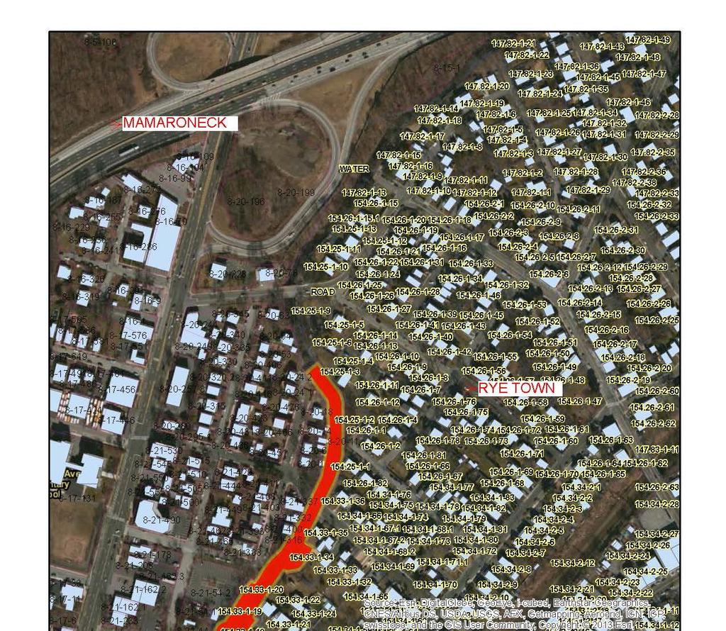
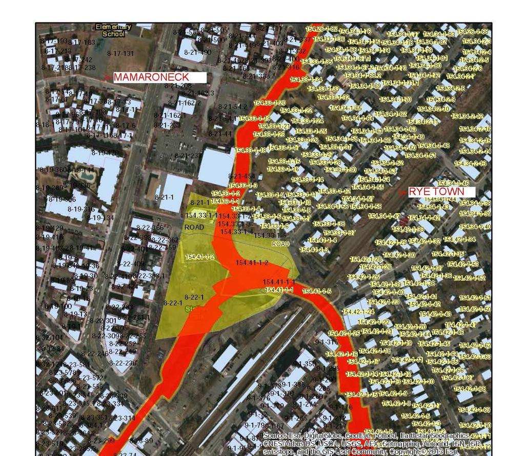
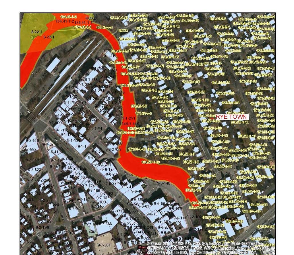
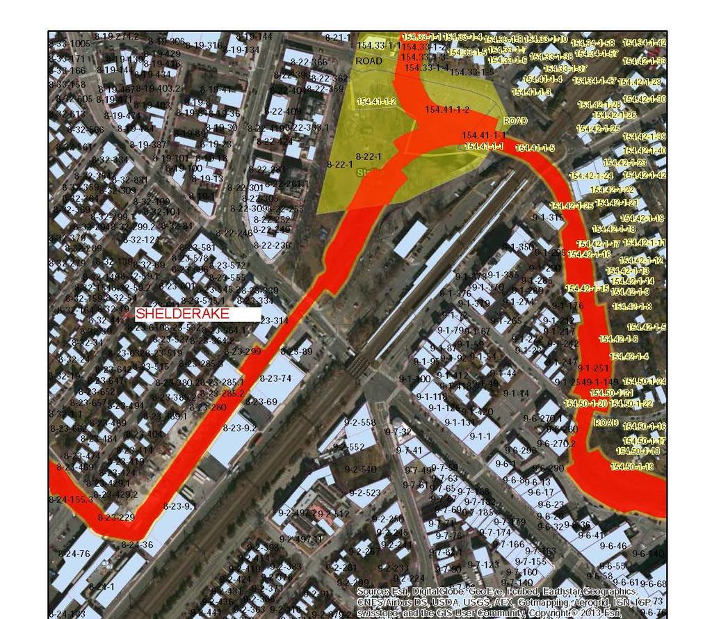
12 Exhibit A Real Estate Maps 10
13 11
14 12
15 13
16 14
17 15
18 Exhibit B Parcel Data 16
19 National Economic Development Plan Parcel Data Municipality SEC_BLK_LOT Channel Improvement Easement (acres) Temporary Work Area Easement (acres) Privately Owned Parcels Mamaroneck Rye Town Rye Town Rye Town Rye Town Rye Town Rye Town Rye Town Rye Town Rye Town Rye Town Rye Town Rye Town Rye Town Rye Town Rye Town Rye Town Rye Town Rye Town Rye Town Rye Town Rye Town Rye Town Mamaroneck Mamaroneck Mamaroneck Mamaroneck 8_21_ Mamaroneck Mamaroneck 8_24_ Mamaroneck Mamaroneck 8_24_ Mamaroneck Mamaroneck Mamaroneck Mamaroneck Mamaroneck Mamaroneck
20 Mamaroneck Mamaroneck 8_20_ Mamaroneck Mamaroneck 8_20_ Mamaroneck 8_20_ Mamaroneck Mamaroneck Mamaroneck Mamaroneck Mamaroneck Mamaroneck Mamaroneck Mamaroneck 8_31_ Mamaroneck Mamaroneck 8_21_ Mamaroneck Mamaroneck Mamaroneck Mamaroneck Mamaroneck 8_23_ Mamaroneck 8_23_ Mamaroneck 8_23_ Mamaroneck Mamaroneck Mamaroneck Mamaroneck Mamaroneck Mamaroneck Mamaroneck Mamaroneck Mamaroneck Mamaroneck Mamaroneck Mamaroneck Mamaroneck Mamaroneck Mamaroneck Mamaroneck Mamaroneck Mamaroneck Mamaroneck Mamaroneck 8 11???
21 Mamaroneck Harrison Harrison Harrison Harrison Harrison Harrison Harrison Publicly Owned Parcels Rye Town _1_ Rye Town _1_ Rye Town _1_ Rye Town _1_ Rye Town _1_ Rye Town _1_ Rye Town _1_ Rye Town _1_ Rye Town _1_ Rye Town _1_ Rye Town _1_ Rye Town _1_ Rye Town _1_ Mamaroneck 9_6_ Mamaroneck 8_31_ Mamaroneck 8_22_ Mamaroneck 8_31_ Mamaroneck 8_31_??? Mamaroneck 8_21_ Public Roads Mararoneck Mamaroneck Harrison 8_11_
22 Exhibit C Standard Estates 20
23 Channel Improvement Easement (Standard Estate No. 8) A perpetual and assignable right and easement to construct, operate, and maintain channel improvement works on, over and across [Section, Block, and Lot] for the purposes as authorized by the Act of Congress approved in Section 401(a) of the Water Resources Development Act of 1986 (Public Law ), including the right to clear, cut, fell, remove and dispose of any and all timber, trees, underbrush, buildings, improvements and/or other obstructions therefrom; to excavate: dredge, cut away, and remove any or all of said land and to place thereon dredge or spoil material; and for such other purposes as may be required in connection with said work of improvement; reserving, however, to the owners, their heirs and assigns, all such rights and privileges as may be used without interfering with or abridging the rights and easement hereby acquired; subject, however, to existing easements far public roads and highways, public utilities, railroads and pipelines. Temporary Work Area Easement (Standard Estate No. 15) A temporary easement and right-of-way in, on, over and across [Section, Block, and Lot] for a period not to exceed three (3) years, beginning with date possession of the land is granted to the United States, for use by the United States, its representatives, agents, and contractors as a work area, including the right to (borrow and/or deposit fill, spoil and waste material thereon) (move, store and remove equipment and supplies, and erect and remove temporary structures on the land and to perform any other work necessary and incident to the construction of the Mamaroneck and Sheldrake River Flood Damage Reduction Project Mamaroneck, New York, together with the right to trim, cut, fell and remove therefrom all trees, underbrush, obstructions, and any other vegetation, structures, or obstacles within the limits of the right-of-way; reserving, however, to the landowners, their heirs and assigns, all such rights and privileges as may be used without interfering with or abridging the rights and easement hereby acquired; subject, however, to existing easements for public roads and highways, public utilities, railroads and pipelines. 21
24 Exhibit D Non-Federal Sponsor Capability Assessment 22
25 ASSESSMENT OF NON-FEDERAL SPONSOR S REAL ESTATE ACQUISITION CAPABILITY MAMARONECK AND SHELDRAKE RIVER FLOOD DAMAGE REDUCTION PROJECT MAMARONECK, NEW YORK I. Legal Authority. a. Does the sponsor have legal authority to acquire and hold title to real property for project purposes? Yes b. Does the sponsor have the power of eminent domain for this project? Yes c. Does the sponsor have quick-take authority for this project? Yes d. Are any of the lands/interests in land required for the project located outside the sponsor s political boundary? No e. Are any of the lands/interests in land required for the project owned by an entity whose property the sponsor cannot condemn? No II. Human Resource Requirements. a. Will the sponsor s in-house staff require training to become familiar with the real estate requirements of Federal projects including P.L , as amended? No b. If the answer to II.a is yes, has a reasonable plan been developed to provide such training? N/A c. Does the sponsor s in-house staff have sufficient real estate acquisition experience to meet its responsibilities for the project? Yes d. Is the sponsor s projected in-house staffing level sufficient considering its other workload, if any, and the project schedule? Yes e. Can the sponsor obtain contractor support, if required in a timely fashion? Yes f. Will the sponsor likely request USACE assistance in acquiring real estate? No; however, the sponsor will work with their local partner, Village of Mamaroneck, in the acquisition process. The village will acquire the real estate for the project and grant access to the Non- Federal Sponsor and to USACE. 23
26 III. Other Project Variables. a. Will the sponsor s staff be located within reasonable proximity to the project site? Yes b. Has the sponsor approved the project/real estate schedule/milestones? Yes IV. Overall Assessment. a. Has the sponsor performed satisfactorily on other USACE projects? Yes b. With regard to this project, the sponsor is anticipated to be: highly capable/fully capable/moderately capable/marginally capable/insufficiently capable. If sponsor is believed to be insufficiently capable, provide explanation. Highly Capable. Even though the nonfederal sponsor will be relying on their local partner, the Village of Mamaroneck, to complete the acquisition of the real estate required for this Project, the Non-Federal Sponsor is highly experienced and highly capable to coordinate all acquisition efforts with the local partner. V. Coordination. a. Has this assessment been coordinated with the sponsor? Yes b. Does the sponsor concur with this assessment? Yes NOREEN DEAN DRESSER Chief, Real Estate Division, Real Estate Contracting Officer 24
27 Exhibit E Real Estate Assessment of Compensability 25
28 26
29 27
30 28
JANUARY 2016 MAMARONECK & SHELDRAKE RIVERS NEW YORK FLOOD RISK MANAGEMENT GENERAL REEVALUATION REPORT FOR THE VILLAGE OF MAMARONECK APPENDIX E
 U.S. Army Corps of Engineers New York District MAMARONECK & SHELDRAKE RIVERS NEW YORK FLOOD RISK MANAGEMENT GENERAL REEVALUATION REPORT FOR THE VILLAGE OF MAMARONECK JANUARY 2016 APPENDIX E REAL ESTATE
Appendix B Real Estate Plan
 Appendix B Real Estate Plan B-1 REAL ESTATE PLAN Prepared for U.S. Army Corps of Engineers Southwestern Division Little Rock District As of May 1, 2013 Prepared by Ronald Bridges Real Estate Division ANY
DRAFT INTEGRATED FEASIBILITY REPORT AND ENVIRONMENTAL ASSESSMENT
 APPENDIX E REAL ESTATE PLAN MT. SINAI MEDICAL CENTER, CONTINUTING AUTHORITIES PROGRAM (CAP) SECTION 14, PROJECT DRAFT INTEGRATED FEASIBILITY REPORT AND ENVIRONMENTAL ASSESSMENT September 2016 DRAFT APPENDIX
Appendix G. Non-Federal Letters of Support and Draft Real Estate Plan
 Appendix G Non-Federal Letters of Support and Draft Real Estate Plan REAL ESTATE PLAN UPPER DELAWARE RIVER WATERSHED FEASABILITY STUDY LIVINGSTON MANOR, NEW YORK 1. GENERAL 2. REAL ESTATE REQUIREMENTS
Appendix B Draft Real Estate Plan
 Appendix B Draft Real Estate Plan B-1 REAL ESTATE PLAN Prepared for U.S. Army Corps of Engineers Southwestern Division Little Rock District As of December 3, 2012 Prepared by Ronald Bridges Real Estate
Draft Appendix E. Real Estate Plan. Rahway River Basin, New Jersey Flood Risk Management Feasibility Study. November 2016
 Draft Appendix E Real Estate Plan Rahway River Basin, New Jersey Flood Risk Management Feasibility Study November 2016 New Jersey Department of Environmental Protection U.S. Army Corps of Engineers New
Appendix H: Real Estate Plan
 APPENDIX H Spring Creek North Ecosystem Restoration Feasibility Study Appendix H: Real Estate Plan New York District U.S. Army Corps of Engineers October 2016 Revised: 13 April 2017 Spring Creek North
APPENDIX M. Real Estate Plan
 APPENDIX M Real Estate Plan Poplar Island Environmental Restoration Project September 2005 General Reevaluation Report (GRR) and Supplemental Environmental Impact Statement (SEIS) REAL ESTATE PLAN (REP)
Draft Continuing Authorities Program Section 1135 Detailed Project Report and Integrated Environmental Assessment
 Appendix G Real Estate Shorty s Island / Meander Reach Ecosystem Restoration Kootenai River, Idaho Draft Continuing Authorities Program Section 1135 Detailed Project Report and Integrated Environmental
Appendix C. Real Estate. Brazos Island Harbor, Texas Channel Improvement Project Cameron County, Texas
 Appendix C Real Estate Brazos Island Harbor, Texas Channel Improvement Project Cameron County, Texas U.S. Army Corps of Engineers, Galveston District 2000 Fort Point Road Galveston, Texas 77550 December
INDIANA HARBOR AND CANAL CONFINED DISPOSAL FACILITY EAST CHICAGO, INDIANA
 INDIANA HARBOR AND CANAL CONFINED DISPOSAL FACILITY EAST CHICAGO, INDIANA APPENDIX J REAL ESTATE Acquisition Branch Real Estate Division Chicago District U.S. Army Corps of Engineers APPENDIX J REAL ESTATE
EDISTO BEACH COASTAL STORM DAMAGE REDUCTION GENERAL INVESTIGATION STUDY APPENDIX K REAL ESTATE
 EDISTO BEACH COASTAL STORM DAMAGE REDUCTION GENERAL INVESTIGATION STUDY APPENDIX K REAL ESTATE Table of Contents REAL ESTATE APPENDIX... I... i SECTION 1. THE REAL ESTATE REPORT... 1 1.1 Statement of Purpose...
Delaware River Basin Comprehensive Flood Risk Management Interim Feasibility Study and Integrated Environmental Assessment for New Jersey
 Delaware River Basin Comprehensive Flood Risk Management Interim Feasibility Study and Integrated Environmental Assessment for New Jersey Flooding in the Study Area, April 2005 June 2015 APPENDIX F: Draft
HASHAMOMUCK COVE, SOUTHOLD, NEW YORK COASTAL STORM RISK MANAGEMENT FEASIBILITY STUDY APPENDIX F REAL ESTATE PLAN
 U.S. Army Corps of Engineers New York District HASHAMOMUCK COVE, SOUTHOLD, NEW YORK COASTAL STORM RISK MANAGEMENT FEASIBILITY STUDY APPENDIX F REAL ESTATE PLAN AUGUST 2016 HASHAMOMUCK COVE, SOUTHOLD, NEW
Appendix D: Real Estate
 Shrewsbury River Basin, Sea Bright, New Jersey Coastal Storm Risk Management Feasibility Study Draft Integrated Feasibility Report & Environmental Assessment Appendix D: Real Estate Shrewsbury River Basin,
WEST SHORE LAKE PONTCHARTRAIN HURRICANE AND STORM DAMAGE RISK REDUCTION STUDY INTEGRATED DRAFT FEASIBILITY REPORT AND ENVIRONMENTAL IMPACT STATEMENT
 WEST SHORE LAKE PONTCHARTRAIN HURRICANE AND STORM DAMAGE RISK REDUCTION STUDY INTEGRATED DRAFT FEASIBILITY REPORT AND ENVIRONMENTAL IMPACT STATEMENT REAL ESTATE PLAN APPENDIX C Annex A: Project Maps Annex
Draft Environmental Impact Statement (EIS)/Environmental Impact Report (EIR) APPENDIX H Real Estate Cost
/Environmental Impact Report (EIR) APPENDIX H Real Estate Cost") Draft Environmental Impact Statement (EIS)/Environmental Impact Report (EIR) APPENDIX H Real Estate Cost US Army Corps of Engineers Corte Madera Creek Flood Risk Management Project October 2018 APPENDIX
Draft Environmental Impact Statement (EIS)/Environmental Impact Report (EIR) APPENDIX H Real Estate Cost US Army Corps of Engineers Corte Madera Creek Flood Risk Management Project October 2018 APPENDIX
HUNTING BAYOU FLOOD RISK MANAGEMENT, HARRIS COUNTY, TEXAS DRAFT GENERAL REEVALUATION REPORT AND INTEGRATED ENVIRONMENTAL ASSESSMENT
 HUNTING BAYOU FLOOD RISK MANAGEMENT, HARRIS COUNTY, TEXAS DRAFT GENERAL REEVALUATION REPORT AND INTEGRATED ENVIRONMENTAL ASSESSMENT APPENDIX 6 REAL ESTATE PLAN June 2014 HARRIS COUNTY FLOOD CONTROL DISTRICT
DRAFT East Rockaway Inlet to Rockaway Inlet and Jamaica Bay. Atlantic Coast of New York
 DRAFT East Rockaway Inlet to Rockaway Inlet and Jamaica Bay Atlantic Coast of New York APPENDIX E REAL ESTATE PLAN AUGUST 2018 East Rockaway Inlet to Rockaway Inlet and Jamaica Bay Reformulation Study
Draft Integrated Feasibility Report and Environmental Assessment and Draft Finding of No Significant Impact
 Draft Integrated Feasibility Report and Environmental Assessment and Draft Finding of No Significant Impact APPENDIX F: REAL ESTATE Whittier, Alaska June 2018 Pacific Ocean Division DRAFT REAL ESTATE
APPENDIX E REAL ESTATE PLAN
 APPENDIX E REAL ESTATE PLAN REAL ESTATE PLAN VILLAGE OF BARBOURSVILLE, WATER STREET, STREAMBANK PROTECTION PROJECT CABELL COUNTY, WEST VIRGINIA SECTION 14 1. Authority/Purpose This Real Estate Plan is
APPENDIX D - REAL ESTATE
 APPENDIX D - REAL ESTATE 1. Purpose Real Estate Plan For Feasibility Study For Lake Lou Yaeger Section 206 Aquatic Ecosystem Restoration Continuing Authorities Project Feasibility Study This report is
CENAN-RE 22 May MEMORANDUM FOR Chief, Planning Division, ATTN: CENAN-PL-F (Alek Petersen)
") CENAN-RE 22 May 2017 MEMORANDUM FOR Chief, Planning Division, ATTN: CENAN-PL-F (Alek Petersen) SUBJECT: May 2017 Real Estate Plan for the Rahway River (Tidal) Basin, Coastal Storm Risk Management Feasibility
CENAN-RE 22 May 2017 MEMORANDUM FOR Chief, Planning Division, ATTN: CENAN-PL-F (Alek Petersen) SUBJECT: May 2017 Real Estate Plan for the Rahway River (Tidal) Basin, Coastal Storm Risk Management Feasibility
APPENDIX F REAL ESTATE
 APPENDIX F REAL ESTATE Real Estate Plan For Broward County, Florida Shore Protection Project Segments II and III General Reevaluation Report 1. Statement Of Purpose. The Real Estate Plan is tentative in
APPENDIX G REAL ESTATE
 BUBBLY CREEK, SOUTH BRANCH OF THE CHICAGO RIVER, ILLINOIS FEASIBILITY STUDY APPENDIX G REAL ESTATE DRAFT - NOT FOR DISTRIBUTION APRIL 2015 U.S. Army Corps of Engineers Chicago District Appendix G Real
REAL ESTATE PLAN APPENDIX G
 Pacific Ocean Division REAL ESTATE PLAN APPENDIX G Alaska District UNALASKA (DUTCH HARBOR) CHANNELS UNALASKA, ALASKA Real Estate Division Alaska District U.S. Army Corps of Engineers TABLE OF CONTENTS
Skagit River Flood Risk Management General Investigation Skagit County, Washington. Draft Feasibility Report and Environmental Impact Statement
 General Investigation Skagit County, Washington Draft Feasibility Report and Environmental Impact Statement May 2014 Real Estate Requirements of Selected Plan This Real Estate Plan Summary (REP) is presented
Appendix K. Real Estate Plan
 Appendix K. Real Estate Plan REAL ESTATE PLAN DELTA ISLANDS AND LEVEES FEASIBILITY STUDY (DELTA STUDY) 20 June 2018 PREPARED BY THE SACRAMENTO DISTRICT U.S. ARMY CORPS OF ENGINEERS 1 TABLE OF CONTENTS
DRAFT REAL ESTATE PLAN APPENDIX D JEFFERSON COUNTY ECOSYSTEM RESTORATION FEASIBILITY STUDY
 DRAFT REAL ESTATE PLAN APPENDIX D JEFFERSON COUNTY ECOSYSTEM RESTORATION FEASIBILITY STUDY (NOTE: This page intentionally left blank.) This Real Estate Plan has been prepared in accordance with ER 405-1-12
Downtown Montauk Stabilization Project. Real Estate Plan Appendix
 Downtown Montauk Stabilization Project Real Estate Plan Appendix October 2014 Table of Contents Page 1. Introduction and General Information 1 a. Authority 2 b. History 2 c. Location Project Study Area
APPENDIX H. Real Estate Plan
 INTEGRATED FEASIBILITY REPORT AND ENVIRONMENTAL IMPACT STATEMENT COASTAL STORM DAMAGE REDUCTION BOGUE BANKS, CARTERET COUNTY NORTH CAROLINA APPENDIX H Real Estate Plan US Army Corps of Engineers Wilmington
UPPER MISSISSIPPI RIVER RESTORATION FEASIBILITY REPORT WITH INTEGRATED ENVIRONMENTAL ASSESSMENT
 UPPER MISSISSIPPI RIVER RESTORATION FEASIBILITY REPORT WITH INTEGRATED ENVIRONMENTAL ASSESSMENT McGregor Lake HABITAT REHABILITATION AND ENHANCEMENT PROJECT POOL 10, UPPER MISSISSIPPI RIVER MILE 635-634
Appendix D Real Estate Plan
 Appendix D Real Estate Plan Matagorda Ship Channel, Port Lavaca, Texas Feasibility Report and Environmental Impact Statement, Review of Completed Projects, Calhoun and Matagorda Counties May 2018 (NOTE:
APPENDIX C REAL ESTATE PLAN BOULEVARD RESACA, BROWNSVILLE, TX CAMERON COUNTY, TEXAS
 APPENDIX C REAL ESTATE PLAN BOULEVARD RESACA, BROWNSVILLE, TX CAMERON COUNTY, TEXAS November 19, 2016 Table of Contents Purpose... 3 Project Authority... 3 Project Location and Description... 3 Non-Federal
Final General Reevaluation Report and Final Environmental Impact Statement. Hurricane Protection and Beach Erosion Control
 Final General Reevaluation Report and Final Environmental Impact Statement on Hurricane Protection and Beach Erosion Control WEST ONSLOW BEACH AND NEW RIVER INLET (TOPSAIL BEACH), NORTH CAROLINA Appendix
APPENDIX H REAL ESTATE REQUIREMENTS
 Malden River Ecosystem Restoration Detailed Project Report APPENDIX H REAL ESTATE REQUIREMENTS April 2007 Malden River Ecosystem Restoration Real Estate Report 1. PURPOSE: The Detailed Project Report
REAL ESTATE PLAN. Final Integrated General Reevaluation Report and Supplemental Environmental Impact Statement
 REAL ESTATE PLAN Final Integrated General Reevaluation Report and Supplemental Environmental Impact Statement Mississippi River, Baton Rouge to the Gulf of Mexico Mississippi River-Gulf Outlet, Louisiana,
DEPARTMENT OF THE ARMY OFFICE OF THE CHIEF OF ENGINEERS WASHINGTON, D.C
 DEPARTMENT OF THE ARMY OFFICE OF THE CHIEF OF ENGINEERS WASHINGTON, D.C. 20314-1000 REPLY TO ATTENTION OF: CECW-PM (10-1-7a) THE SECRETARY OF THE ARMY 1. I submit for transmission to Congress my report
Land Management Plan Fargo-Moorhead (FM) Area Flood Risk Reduction Project Version 1
 Area Flood Risk Reduction Project Version 1") Land Management Plan Fargo-Moorhead (FM) Area Flood Risk Reduction Project Version 1 Prepared for Fargo-Moorhead Area Flood Diversion Board of Authority July 12, 2012 REV 1 Contents Section Page Acronyms
Land Management Plan Fargo-Moorhead (FM) Area Flood Risk Reduction Project Version 1 Prepared for Fargo-Moorhead Area Flood Diversion Board of Authority July 12, 2012 REV 1 Contents Section Page Acronyms
APPENDIX H REAL ESTATE PLAN
 APPENDIX H REAL ESTATE PLAN This page intentionally left blank. APPENDIX H REAL ESTATE PLAN DALLAS FLOODWAY FEASIBILITY STUDY DATE OF REPORT January 31, 2014 PREPARED BY REAL ESTATE DIVISION U.S. ARMY
APPENDIX D REAL ESTATE PLAN
 APPENDIX D REAL ESTATE PLAN APPENDIX D REAL ESTATE PLAN TABLE OF CONTENTS 1. STATEMENT OF PURPOSE 2. REFERENCES 3. AUTHORIZATION 4. BACKGROUND 5. LOCATION 6. REAL ESTATE REQUIREMENTS 7. OWNERSHIP OF REAL
APPENDIX F REAL ESTATE PLAN. Redwood City Harbor Navigation Improvement Feasibility Study, Redwood City, California
 APPENDIX F REAL ESTATE PLAN Redwood City Harbor Navigation Improvement Feasibility Study, Redwood City, California PREPARED FOR THE SAN FRANCISCO DISTRICT SOUTH PACIFIC DIVISION 20 April 2015 PREPARED
Real Estate Plan Beaver Lake Water Supply Reallocation White River Rogers, Arkansas. 20 April 2017
 Real Estate Plan Beaver Lake Water Supply Reallocation White River Rogers, Arkansas 20 April 2017 Prepared For US Army Corps of Engineers Southwestern Division Little Rock District Prepared By Jeremy R.
AGREEMENT TO ACQUIRE LANDS BETWEEN THE DEPARTMENT OF THE ARMY ST. PAUL DISTRICT, CORPS OF ENGINEERS AND. THE CITY OF City, State
 AGREEMENT TO ACQUIRE LANDS BETWEEN THE DEPARTMENT OF THE ARMY ST. PAUL DISTRICT, CORPS OF ENGINEERS AND THE CITY OF City, State FOR CONDEMNATION ON BEHALF OF THE SPONSOR BY THE CORPS OF ENGINEERS FOR THE
DRAFT REAL ESTATE PLAN APPENDIX C GULF INTRACOASTAL WATERWAY BRAZOS RIVER FLOODGATES AND COLORADO RIVER LOCKS SYSTEMS FEASIBILITY STUDY
 DRAFT REAL ESTATE PLAN APPENDIX C GULF INTRACOASTAL WATERWAY BRAZOS RIVER FLOODGATES AND COLORADO RIVER LOCKS SYSTEMS FEASIBILITY STUDY This Real Estate Plan has been prepared in accordance with ER 405-1-12
UPPER MISSISSIPPI RIVER RESTORATION FEASIBILITY REPORT WITH INTEGRATED ENVIRONMENTAL ASSESSMENT
 UPPER MISSISSIPPI RIVER RESTORATION FEASIBILITY REPORT WITH INTEGRATED ENVIRONMENTAL ASSESSMENT BEAVER ISLAND HABITAT REHABILITATION AND ENHANCEMENT PROJECT POOL 14, UPPER MISSISSIPPI RIVER MILES 513.0-517.0
Southwest Coastal Louisiana Study
 REAL ESTATE PLAN Annex 1: Project Maps Annex 2: Assessment of Non-Federal Sponsor s Acquisition Capability Annex 3: Non-Material Deviation from Standard Estate Perpetual Access Easement Annex 4: Baseline
Mississippi River Ship Channel Gulf to Baton Rouge, LA Integrated General Reevaluation Report And Supplemental Environmental Impact Statement
 APPENDIX B Real Estate Plan B-1.0 PROJECT PURPOSE, DESCRIPTION, LOCATION AND DESCRIPTION OF THE LANDS, EASEMENTS, RIGHTS-OF-WAY, RELOCATIONS AND DISPOSAL (LERRD) REQUIRED The purpose of this Real Estate
Dredged Material Management Plan Atlantic Intracoastal Waterway Port Royal Sound, South Carolina to Cumberland Sound, Georgia November 2015
 Dredged Material Management Plan Atlantic Intracoastal Waterway Port Royal Sound, South Carolina to Cumberland Sound, Georgia November 2015 Appendix H: Real Estate US Army Corps of Engineers South Atlantic
GENERAL RE-EVALUATION REPORT APPENDIX B: REAL ESTATE SAVANNAH HARBOR EXPANSION PROJECT Chatham County, Georgia and Jasper County, South Carolina
 GENERAL RE-EVALUATION REPORT APPENDIX B: REAL ESTATE SAVANNAH HARBOR EXPANSION PROJECT Chatham County, Georgia and Jasper County, South Carolina January 2012 (Revised July 2012) US Army Corps of Engineers
BEACH STORM DAMAGE REDUCTION EASEMENT
 STATE OF FLORIDA COUNTY OF WALTON WALTON COUNTY, FL HURRICANE & STORM DAMAGE REDUCTION PROJECT FILE/REACH#: PARCEL ID#: BEACH STORM DAMAGE REDUCTION EASEMENT KNOW ALL MEN BY THESE PRESENTS, that for and
Hazardous Materials in Project Development Additional Guidance
 Hazardous Materials in Project Development Additional Guidance Contents:...2 AASHTO Guidance...3 USDOT Brownfields Guidance...4 ASTM Standard Practices...6 Hazardous Materials in Project Development 1
Appendix J. Real Estate Plan
 Appendix J Real Estate Plan Real Estate Plan Louisiana Coastal Area Near-Term Ecosystem Restoration Plan Medium Diversion at White Ditch 1. PURPOSE Title VII of the Water Resources Development Act of 2007
MIDDLE RIO GRANDE FLOOD PROTECTION, BERNALILLO TO BELEN, NM PROJECT BERNALILLO AND VALENCIA COUNTIES, NEW MEXICO. Appendix I Real Estate Plan
 MIDDLE RIO GRANDE FLOOD PROTECTION, BERNALILLO TO BELEN, NM PROJECT BERNALILLO AND VALENCIA COUNTIES, NEW MEXICO Appendix I Real Estate Plan LOS ANGELES DISTRICT ASSET MANAGEMENT US Army Corps Of Engineers
U.S. Army Corps of Engineers Charleston District APPENDIX E CHARLESTON HARBOR POST 45 CHARLESTON, SOUTH CAROLINA. Real Estate
 U.S. Army Corps of Engineers Charleston District APPENDIX E CHARLESTON HARBOR POST 45 CHARLESTON, SOUTH CAROLINA Real Estate May 2015 Table of Contents REAL ESTATE APPENDIX E... I... i... i SECTION 1.
APPENDIX D REAL ESTATE DRAFT. MOBILE HARBOR, MOBILE, ALABAMA Integrated General Reevaluation Report With Supplemental Environmental Impact Statement
 APPENDIX D REAL ESTATE DRAFT MOBILE HARBOR, MOBILE, ALABAMA Integrated General Reevaluation Report With Supplemental Environmental Impact Statement Table of Contents 1. Purpose of the Real Estate Plan
WESTMINSTER, EAST GARDEN GROVE FLOOD RISK MANAGEMENT STUDY
 Ver. 24 Oct 2018 WESTMINSTER, EAST GARDEN GROVE FLOOD RISK MANAGEMENT STUDY FEASIBILITY REPORT AND INTEGRATED ENVIRONMENTAL IMPACT REPORT REAL ESTATE PLANNING REPORT SEPTEMBER 2018 APPENDIX D DRAFT REAL
DEPARTMENT OF THE ARMY U.S. Army Corps of Engineers Washington, DC Regulation No May 2015
 CEMP-CR DEPARTMENT OF THE ARMY U.S. Army Corps of Engineers Washington, DC 20314-1000 ER 405-1-19 Regulation No. 405-1-19 29 May 2015 Real Estate ACQUISITION BY CONDEMNATION PROCEEDINGS 1. Purpose. Engineer
Appendix C REAL ESTATE PLAN
 Appendix C RAL STAT PLAN Section 203 Integrated Feasibility Report and Draft nvironmental Impact Statement RAL STAT PLAN HOUMA NAVIGATION CANAL CHANNL DPNING MIL 36.3 TO MIL 3.7 TRRBONN PARISH, LOUISIANA
DEPARTMENT OF THE ARMY OFFICE OF THE CHIEF OF ENGINEERS WASHINGTON. D.C MAR
 DEPARTMENT OF THE ARMY OFFICE OF THE CHIEF OF ENGINEERS WASHINGTON. D.C. 2031 4-1 000 MAR 3 1 2006 CEMP-NAD (1 0-1-7a) THE SECRETARY OF THE ARMY 1. I submit for transmission to Congress my report on the
EASEMENT AGREEMENT. hereinafter called Grantor, (whether grammatically singular or plural) and the:
 and the:") EASEMENT AGREEMENT THIS EASEMENT AGREEMENT, made and entered into as of the day of,, by and between: hereinafter called Grantor, (whether grammatically singular or plural) and the: hereinafter called Distributor.
EASEMENT AGREEMENT THIS EASEMENT AGREEMENT, made and entered into as of the day of,, by and between: hereinafter called Grantor, (whether grammatically singular or plural) and the: hereinafter called Distributor.
1. GENERAL 2. REAL ESTATE REQUIREMENTS
 1. GENERAL APPENDIX E REAL ESTATE PLAN FOR THE SECTION 205, TOOKANY CREEK FLOOD RISK MANAGEMENT FEASIBILITY STUDY TOWNSHIP, MONTGOMERY COUNTY PENNSYLVANIA 2. REAL ESTATE REQUIREMENTS a. Description of
APPENDIX D REAL ESTATE
 APPENDIX D REAL ESTATE American River Watershed Common Features General Reevaluation Report Real Estate Plan February 2015 1 Cover Photos courtesy of the Sacramento District: Sacramento Weir during operation
City of East Providence
 City of East Providence 145 TAUNTON AVENUE, EAST PROVIDENCE STATE OF RHODE ISLAND AND PROVIDENCE PLANTATIONS 02914-4505 TEL. (401) 435-7521 FAX (401) 438-1719 TDD (401) 431-1633 CITY MANAGER PETER GRACZYKOWSKI
PUGET SOUND NEARSHORE ECOSYSTEM RESTORATION
 PUGET SOUND NEARSHORE ECOSYSTEM RESTORATION APPENDIX C REAL ESTATE PLAN Integrated Feasibility Report and Environmental Impact Statement This page was intentionally left blank to facilitate double sided
MAMARONECK & SHELDRAKE RIVERS NEW YORK FLOOD RISK MANAGEMENT GENERAL REEVALUATION REPORT FOR THE VILLAGE OF MAMARONECK
 MAMARONECK & SHELDRAKE RIVERS NEW YORK FLOOD RISK MANAGEMENT GENERAL REEVALUATION REPORT FOR THE VILLAGE OF MAMARONECK APPENDIX C5: COST ESTIMATES JANUARY 2016 Table of Contents Introduction... C1 Basis
Town of Surf City. City Council Presentation April 2, 2013 PETER A. RAVELLA, PRINCIPAL PAR CONSULTING, LLC
 Town of Surf City City Council Presentation April 2, 2013 PETER A. RAVELLA, PRINCIPAL CONSULTING, LLC I. Review Workshop schedule & Input SC-NTB Federal Project Plan 1550 Funding Contributors You re Not
PLANNING & DEVELOPMENT SERVICES 1800 Continental Place Mount Vernon, WA Inspections Office Fax 360.
 PLANNING & DEVELOPMENT SERVICES 1800 Continental Place Mount Vernon, WA 98273 Inspections 360.416.1330 Office 360.416-1320 Fax 360.416-1340 Date Received: Administrative Setback Reduction Checklist Pursuant
Flood Hazard Development Permit Application & Permit Forms. For Communities with Coastal Velocity Zones [60.3(e)] CONTENTS
![Flood Hazard Development Permit Application & Permit Forms. For Communities with Coastal Velocity Zones [60.3(e)] CONTENTS](/thumbs/76/74346075.jpg "Flood Hazard Development Permit Application & Permit Forms. For Communities with Coastal Velocity Zones [60.3(e)] CONTENTS") Flood Hazard Development Permit Application & Permit Forms For Communities with Coastal Velocity Zones [60.3(e)] CONTENTS 1. Decision Tree 2. Flood Hazard Development Permit Application 3. Flood Hazard
Flood Hazard Development Permit Application & Permit Forms For Communities with Coastal Velocity Zones [60.3(e)] CONTENTS 1. Decision Tree 2. Flood Hazard Development Permit Application 3. Flood Hazard
EASEMENT AGREEMENT. hereinafter called Grantor, (whether grammatically singular or plural) and the:
 and the:") EASEMENT AGREEMENT THIS EASEMENT AGREEMENT made and entered into as of the day of,, by and between: hereinafter called Grantor, (whether grammatically singular or plural) and the: hereinafter called Distributor.
EASEMENT AGREEMENT THIS EASEMENT AGREEMENT made and entered into as of the day of,, by and between: hereinafter called Grantor, (whether grammatically singular or plural) and the: hereinafter called Distributor.
EASEMENT AGREEMENT (Distributor Performance Non-Exclusive)
") EASEMENT AGREEMENT (Distributor Performance Non-Exclusive) THIS EASEMENT AGREEMENT, effective the day of, 20, is made between WITNESSETH:, hereafter called Grantor, (whether grammatically singular or plural)
EASEMENT AGREEMENT (Distributor Performance Non-Exclusive) THIS EASEMENT AGREEMENT, effective the day of, 20, is made between WITNESSETH:, hereafter called Grantor, (whether grammatically singular or plural)
CHAPTER 6 CHESAPEAKE BAY PRESERVATION AREAS AND STREAM PROTECTION AREAS
 CHAPTER 6 CHESAPEAKE BAY PRESERVATION AREAS AND STREAM PROTECTION AREAS 6.1 INTRODUCTION Virginia s Chesapeake Bay Preservation Area (CBPA) Designation and Management Regulations (9VAC10-20 et seq.) require
Technical Information Paper No
 Environmental Condition of Property (ECOP) Investigations Technical Information Paper No. 38-001-0312 PURPOSE. To provide information on ECOP investigations for Federal real property transactions and military
PLANNING SERVICES FORM 3.3 SUBDIVISION APPLICATION COMMERCIAL OR BUSINESS PURPOSES
 FOR OFFICE USE ONLY Date of Receipt File Number Fee Submitted SUBDIVISION APPLICATION COMMERCIAL OR BUSINESS PURPOSES Accepted by Please note that the information provided in these forms is crucial to
Minnesota Pollution Control Agency Voluntary Investigation and Cleanup
 Minnesota Pollution Control Agency Voluntary Investigation and Cleanup Summary of Applicable Laws 1.0 Introduction Guidance Document #3 Over the past few years, the Minnesota Superfund law, known as the
DWR REAL ESTATE COORDINATION PLAN
 DWR REAL ESTATE COORDINATION PLAN Exhibit E DWR PROPERTY ACQUISTION PLAN EXHIBIT E Revised Date: 5 10 18 DWR PROPERTY ACQUISTION PLAN EXHIBIT E Revised Date: 5-10-2018 California WaterFix Real Estate Coordination
The Drainage Control Regulations
 1 The Drainage Control Regulations Repealed by Saskatchewan Regulations 89/2015 (effective October 16, 2015) Formerly Chapter D-33.1 Reg 1 (effective August 18, 1981) as amended by Saskatchewan Regulations
Displacement and Relocation A. INTRODUCTION B. METHODOLOGY
 Appendix F: Displacement and Relocation A. INTRODUCTION This appendix provides additional information to support the analyses provided in Chapter 8, Displacement and Relocation. The focus of Chapter 8,
BRISTOL CONSERVATION COMMISSION INLAND WETLANDS AGENCY FORM IW-1 (Application for a Wetlands Permit)
") APPLICATION NO. BRISTOL CONSERVATION COMMISSION INLAND WETLANDS AGENCY FORM IW-1 (Application for a Wetlands Permit) DATE FILED: APPROVED: DENIED: 1. APPLICANT: Name: Signature: Address: City: State: Zip
APPLICATION NO. BRISTOL CONSERVATION COMMISSION INLAND WETLANDS AGENCY FORM IW-1 (Application for a Wetlands Permit) DATE FILED: APPROVED: DENIED: 1. APPLICANT: Name: Signature: Address: City: State: Zip
APPENDIX L NONSTRUCTURAL IMPLEMENTATION PLAN
 NONSTRUCTURAL IMPLEMENTATION PLAN Table of Contents A. DEFINITIONS... 3 B. INTRODUCTION... 4 C. ELEVATION OF ELIGIBLE RESIDENTIAL STRUCTURES... 5 1. DETERMINING ELIGIBILITY: 2 STEP ELIGIBILITY PROCESS...
ARTICLE I. IN GENERAL
 Adopted by City Council on December 7, 2009 AN ORDINANCE TO AMEND AND REORDAIN CHAPTER 10 (WATER PROTECTION) OF THE CODE OF THE CITY OF CHARLOTTESVILLE, 1990, AS AMENDED, BY DELETING SECTIONS 10-51 AND
SEQRA (For Land Surveyors) Purpose of this Presentation
 Purpose of this Presentation") SEQRA (For Land Surveyors) Purpose of this Presentation Understand the basics and legal requirements of SEQRA Recognize the role that Land Surveyors play in the SEQRA Identify the problems posed by SEQRA
SEQRA (For Land Surveyors) Purpose of this Presentation Understand the basics and legal requirements of SEQRA Recognize the role that Land Surveyors play in the SEQRA Identify the problems posed by SEQRA
SAMPLE 1 INDUCEMENT AND INDEMNITY AGREEMENT LETTER
 SAMPLE 1 INDUCEMENT AND INDEMNITY AGREEMENT LETTER (Date) Ohio Housing Finance Agency 57 E. Main Street Columbus, OH 43215-5135 RE: (Project Name) Colleagues: We have this day filed with the Ohio Housing
Federal Mandates and Willing Sellers: Real Estate Acquisition for the Missouri River Recovery Program
 Federal Mandates and Willing Sellers: Real Estate Acquisition for the Missouri River Recovery Program Brad Thompson, Chief, Civil Works Branch U.S. Corps of Engineers, Omaha District US Army Corps of Engineers
EXHIBIT 2 NOTICE OF INTENTION OF THE BOARD OF SUPERVISORS. OF TilE COUNTY OF ORANGE, CALIFORNIA, ACTING AS
 OF REAL PROPERTY DETERMINING THE NECESSITY OF ACQUISITION BY EMINENT DOMAIN DISTRICT, TO CONSIDER FOR ADOPTION A RESOLUTION THE GOVERNING BOARD OF THE ORANGE COUNTY FLOOD CONTROL OF TilE COUNTY OF ORANGE,
Surabaya River Improvement Project (II-1)
") Indonesia 1. Project Profile and Japan s ODA Loan (1) Background Surabaya River Improvement Project (II1) Report Date: June 2 Field Survey: February 2 When this project was planned in 199, the city of
Indonesia 1. Project Profile and Japan s ODA Loan (1) Background Surabaya River Improvement Project (II1) Report Date: June 2 Field Survey: February 2 When this project was planned in 199, the city of
CITY OF FORT COLLINS NATURAL AREAS AND CONSERVED LANDS EASEMENT POLICY
 CITY OF FORT COLLINS NATURAL AREAS AND CONSERVED LANDS EASEMENT POLICY Adopted January 3, 2012 PURPOSE: The purpose of the policy statement is to clarify the policies and procedures of the City of Fort
THE REGULATIONS GOVERNING SOIL DISPLACEMENT AND DISPOSAL IN THE EAST HELENA SUPERFUND AREA IN LEWIS AND CLARK COUNTY, MONTANA.
 THE REGULATIONS GOVERNING SOIL DISPLACEMENT AND DISPOSAL IN THE EAST HELENA SUPERFUND AREA IN LEWIS AND CLARK COUNTY, MONTANA. 2013 Lewis & Clark City-County Health Department Lead Education and Abatement
July 1, 2017 HAZARDOUS SITE INVENTORY Environmental Protection Division Georgia Department of Natural Resources
 July 1, 2017 HAZARDOUS SITE INVENTORY Environmental Protection Division Georgia Department of Natural Resources HSI INTRO -i- July 1, 2017 INTRODUCTION TO THE HAZARDOUS SITE INVENTORY The purpose of this
TOWN OF MANSFIELD RULES AND REGULATIONS FOR THE EXTENSION OF PUBLIC SEWERS
 TOWN OF MANSFIELD RULES AND REGULATIONS FOR THE EXTENSION OF PUBLIC SEWERS BOARD OF WATER & SEWER COMMISSIONERS Mansfield Board of Selectmen Adopted April 3, 1996 CONTENTS DEFINITIONS... Page 2 POLICY
(Chapter Flood Damage Prevention)
") Chapter 13.10 Flood Damage Prevention Section: 13.10.010 Purpose and Policy 13.10.020 Definitions 13.10.030 Applicability and Areas of Special Flood Hazard 13.10.040 Administration 13.10.050 Provisions
Chapter 13.10 Flood Damage Prevention Section: 13.10.010 Purpose and Policy 13.10.020 Definitions 13.10.030 Applicability and Areas of Special Flood Hazard 13.10.040 Administration 13.10.050 Provisions
MINNESOTA POLLUTION CONTROL AGENCY GENERAL PERMIT FOR DISPOSAL OF UNCOMTAMINATED CONCRETE
 MINNESOTA POLLUTION CONTROL AGENCY GENERAL PERMIT FOR DISPOSAL OF UNCOMTAMINATED CONCRETE ISSUANCE DATE: December 23, 2013 EXPIRATION DATE: December 23. 2018 This permit is a General Permit issued pursuant
For Sale SEALED BID SALE. Sale No. GSA-R Former Missile Launch Facilities Whiteman AFB, Missouri
 For Sale SEALED BID SALE Sale No. 7 Former Missile Launch Facilities Whiteman AFB, Missouri Located in Bates, Johnson, Pettis and Saline Counties, Missouri BID OPENING August 16, 2005 U.S. General Services
Appendix F. Real Estate
 Appendix F Real Estate U.S. Army Corps of Engineers Galveston District Southwestern Division Appendix F Real Estate Plan for Coastal Texas Protection and Restoration Study Integrated Feasibility Report
Directions For Filling Out A CAMA MINOR Permit
 Directions For Filling Out A CAMA MINOR Permit Please fill out the application completely including applicant's signature on the second page. Be sure to complete the "statement of ownership" and the "adjacent
BROWNFIELD CLEANUP PROGRAM (BCP) APPLICATION FORM
 APPLICATION FORM") BROWNFIELD CLEANUP PROGRAM (BCP) APPLICATION FORM PART A (note: application is separated into Parts A and B for DEC review purposes) Section I. Requestor Information - See Instructions for Further Guidance
BROWNFIELD CLEANUP PROGRAM (BCP) APPLICATION FORM PART A (note: application is separated into Parts A and B for DEC review purposes) Section I. Requestor Information - See Instructions for Further Guidance
VOLUNTARY SALES ASSISTANCE PROGRAM CONSISTING OF TWO OPTIONS:
 VOLUNTARY SALES ASSISTANCE PROGRAM CONSISTING OF TWO OPTIONS: STANDARD SALES ASSISTANCE PROGRAM & CONVEYANCE AND RELEASE PROGRAM POLICIES AND PROCEDURES MANUAL Broward County Aviation Department Fort Lauderdale
CHAPTER 15: ENVIRONMENTAL REVIEW
 CHAPTER 15: ENVIRONMENTAL REVIEW CHAPTER PURPOSE & CONTENTS This chapter provides grantees with general information on environmental review. The chapter will provide an overview of the applicable regulations,
In previous editions of Environment and the
 environment and the appraiser The EPA s Proposed All Appropriate Inquiries Rule and the Appraisal of Contaminated Properties by Thomas O. Jackson, PhD, MAI In previous editions of Environment and the Appraiser,
Referred to Committee on Judiciary. SUMMARY Revises provisions governing eminent domain. (BDR 3-132)
") S.B. SENATE BILL NO. SENATOR LESLIE PREFILED JANUARY, 0 Referred to Committee on Judiciary SUMMARY Revises provisions governing eminent domain. (BDR -) FISCAL NOTE: Effect on Local Government: No. Effect
S.B. SENATE BILL NO. SENATOR LESLIE PREFILED JANUARY, 0 Referred to Committee on Judiciary SUMMARY Revises provisions governing eminent domain. (BDR -) FISCAL NOTE: Effect on Local Government: No. Effect