CENAN-RE 22 May MEMORANDUM FOR Chief, Planning Division, ATTN: CENAN-PL-F (Alek Petersen)
|
|
|
- Ellen Murphy
- 5 years ago
- Views:
Transcription
1 CENAN-RE 22 May 2017 MEMORANDUM FOR Chief, Planning Division, ATTN: CENAN-PL-F (Alek Petersen) SUBJECT: May 2017 Real Estate Plan for the Rahway River (Tidal) Basin, Coastal Storm Risk Management Feasibility Study 1. Enclosed is the Real Estate Plan (REP) for the subject project. The REP identifies and describes the real estate requirements to support the construction, operation and maintenance of the project. 2. The point of contact for this report is the Real Estate s PDT member, Erica Labeste, X CF: CENAN-PP-C (ATTN: Rifat Salim) NOREEN D. DRESSER Chief, Real Estate Division Real Estate Contracting Officer

2 RAHWAY RIVER (TIDAL) BASIN COASTAL STORM RISK MANAGEMENT FEASIBILITY STUDY REAL ESTATE PLAN MAY 2017 New Jersey Department of Environmental Protection U.S. Army Corps of Engineers New York District
3 RAHWAY RIVER (TIDAL) BASIN COASTAL STORM RISK MANAGEMENT FEASIBILITY STUDY Table of Contents MAY 2017 REAL ESATE PLAN Page 1. Preamble i 2. Statement of Purpose Project Purpose and Features a. Purpose b. Plan of Improvement c. Required Lands, Easements, Right-of-Way (LER) LER Owned by the Non-Federal Sponsor Non-Standard Estates Existing Federal Projects Federally-Owned Lands Navigational Servitude Maps Induced Flooding Base Line Cost Estimate for Real Estate Public Law , Uniform Relocations Assistance Mineral and Timber Activity Non-Federal Sponsor Capability Zoning Schedule of Acquisition Utility/Facility Relocation Hazardous, Toxic, and Radioactive Waste (HTRW) Project Support Notification to Non-Federal Sponsor Other Issues Point of Contacts Recommendations Exhibits and Attachments Exhibit A - Real Estate Maps Exhibit B - Impacted Parcels and LER to be Acquired Exhibit C - Standard Estates Exhibit D - Baseline Cost Estimate for Real Estate Exhibit E - Non-Federal Sponsor Capability Assessment Checklist
4 Preamble Project Authorization: The U.S. Army Corps of Engineers (Corps) has been authorized to conduct a feasibility study to evaluate Federal participation in coastal storm risk management in the Rahway River Basin, New Jersey. The study is being conducted under the Corps General Investigations (GI) Program. The study was authorized in a resolution of the Committee on Transportation and Infrastructure of the U.S. House of Representatives. The Rahway River Basin resolution was dated 24 March Resolved by the Committee on Transportation and Infrastructure of the United States House of Representatives, That, the Secretary of the Army review the report of the Chief of Engineers on the Rahway River, New Jersey, published as House Document 67, 89th Congress, and other pertinent reports to determine whether any modifications of the recommendations contained therein are advisable at the present time, in the interest of water resources development, including flood damage reduction, environmental restoration and protection and other related purposes. The Disaster Relief Appropriations Act of 2013 was passed by Congress and signed into law by the President on January 29, 2013 as Public Law (Act). The legislation provides supplemental appropriations to address damages caused by Hurricane Sandy and to reduce future flood risk in ways that will support the long-term sustainability of the coastal ecosystem and communities, and reduce the economic costs and risks associated with large-scale flood and storm events. Hurricane Sandy was a catastrophic storm that struck the Atlantic coastline in late October 2012, resulting in loss of life, severe damage to the coastline, widespread power outages, and damage to infrastructure, businesses and private residences. The storm also resulted in degraded coastal features, which has increased the risks of and vulnerability to future storms. Expected changes in sea level rise, an increased probability of extreme weather events, and other impacts of climate change are likely to increase those risks even further. Based on the Disaster Relief Appropriations Act of 2013, this coastal storm risk management study in the Rahway River Basin was initiated by separating coastal storm risk management from the existing and ongoing fluvial flood risk management study for the Rahway River Basin, New Jersey. The Corps has determined that fluvial and tidal flooding are distinct from one another. Official Project Designation: Rahway River (Tidal) Basin Coastal Storm Risk Management Feasibility Study (the Rahway Tidal Project or Project ). Project Location: The Rahway River Basin is located in northeastern New Jersey. It lies within the metropolitan area of Greater New York City and occupies approximately 15 percent of Essex County, 35 percent of Union County, and 10 percent of Middlesex County. The basin is 83.3 square miles (53,300 acres) in area and is roughly crescent-shaped. Its greatest width is approximately 10 miles in the east-west direction, from the City of Linden to the City of Plainfield. Its greatest length is approximately 18 miles in a north south direction, from West Orange to Metuchen. i
5 The Rahway River consists of the mainstem Rahway River and four branches. The West Branch flows south from Verona through South Mountain Reservation and downtown Millburn. The East Branch originates in West Orange and Montclair and travels through South Orange and Maplewood. These two branches converge near Route 78 in Springfield to form the Rahway River which flows through the municipalities of Springfield, Union, Cranford and Clark. The Rahway River then travels through Rahway, entering from Clark at Rahway River Park. The river receives the waters of Robinsons Branch at Elizabeth Avenue between West Grand Avenue and West Main Street and the waters of the South Branch at East Hazelwood Avenue and Leesville Avenue. Finally the river leaves Rahway to enter the city limits of Linden and Carteret before flowing into the Arthur Kill. Figure 1 below displays the Rahway River Basin. Figure 2 below illustrates the location of the tidal floodplain in relation to the Rahway River Basin. The crosshatched area in Figure 2 is the study area. The study area is the tidally influenced lower portion of the Rahway River. The study area encompasses portions of the Cities of Linden and Rahway in Union County and the Borough of Carteret and Woodbridge Township in Middlesex County. The tidal influence on the Rahway River extends roughly five miles from the Arthur Kill into the City of Rahway. The City of Rahway is located in southern Union County, New Jersey. According to the United States Census Bureau, Rahway has a total area of square miles. Of this area, square miles is land and square miles (3.26%) is water. Rahway is bordered to the northwest by Clark, the northeast by Linden and to the south by Woodbridge Township in Middlesex County. Woodbridge Township has a total area of square miles ( km2), including square miles of land and square miles of water (5.28%). The City of Linden has a total area of square miles, including square miles of land and square miles of water (6.42%). The Borough of Carteret has a total area of square miles, including square miles of land and square miles of water (11.65%). The study area is developed and contains residential, commercial and industrial structures within the floodplain. It is largely suburban and urban with little available open space and lies within the 10th Congressional District, which is currently represented by Donald Payne (D-NJ). Non-Federal Sponsor: The Non-Federal Sponsor for the Project is the State of New Jersey thru its Department of Environmental Protection (the Sponsor or NJDEP ). i
6 1. Statement of Purpose The purpose of this Real Estate Plan (REP) is to provide an overview of the real estate requirements for the Project. Note, the Rahway River (Fluvial) Basin Coastal Storm Risk Management Feasibility Study is proceeding separately and contemporaneously with this Project. The REPs for each project are separate. 2. Project Purpose and Features a. Project Purpose: The purpose of this study is to determine whether there is a Federal interest in providing coastal storm risk management measures in the Rahway River Basin, New Jersey. Tidal inundation and storm risk management will be examined by following the plan formulation process as documented in ER , or the Planning Guidance Notebook. This study is being conducted with the intention, if warranted, of developing a site-specific plan to reduce damages in the basin due to tidally induced storm surge. The analysis conducted during the study would be documented in a Feasibility Report and Appendices intended to be a final response to the study authority. b. Plan of Improvement: In support of coastal storm risk management objectives, the plan of improvement requires the construction of: 1) Segment D, a 3,360 ft levee; 2) nonstructural treatment of 136 structures within the 10% floodplain; and potentially 3) Segment A, consisting of levees, floodwalls, channel modification, bridge replacement and a road closure gate located on both banks of the Rahway River between Rahway River Park and the Lawrence Street Bridge in Rahway. I. Segment D: This Levee segment is 3,360 ft long with a 12 ft top width and one vertical to three horizontal (1:3) side slopes with an average height of approximately 7.5 ft The design height of the levee was evaluated at elevation 12.6 ft NAVD 88, consistent with the existing levees in the City of Rahway. The levee is located next to the right bank of the Rahway River, approximately 1.2 miles downstream of the confluence with the South Branch. Nonstructural recommendations on the protected side of this levee were omitted. II. Nonstructural: Alternative #4a thus selected nonstructural treatment for approximately 136 structures (125 residential, 11 non-residential) of the 577 structures (211 residential, 366 non-residential) contained in the 10% ACE (10-yr) floodplain. Nonstructural measures were designed for future conditions 1% ACE (100-yr) WSE plus one foot to account for water surface perturbations. No treatment is recommended at this time for the remaining 441 structures within the floodplain. III. Project Phases: The Project will be implemented in four phases: The phases of construction for the Project have not been determined as of the writing of this appendix. This appendix will be amended once a schedule for construction has been developed. 1
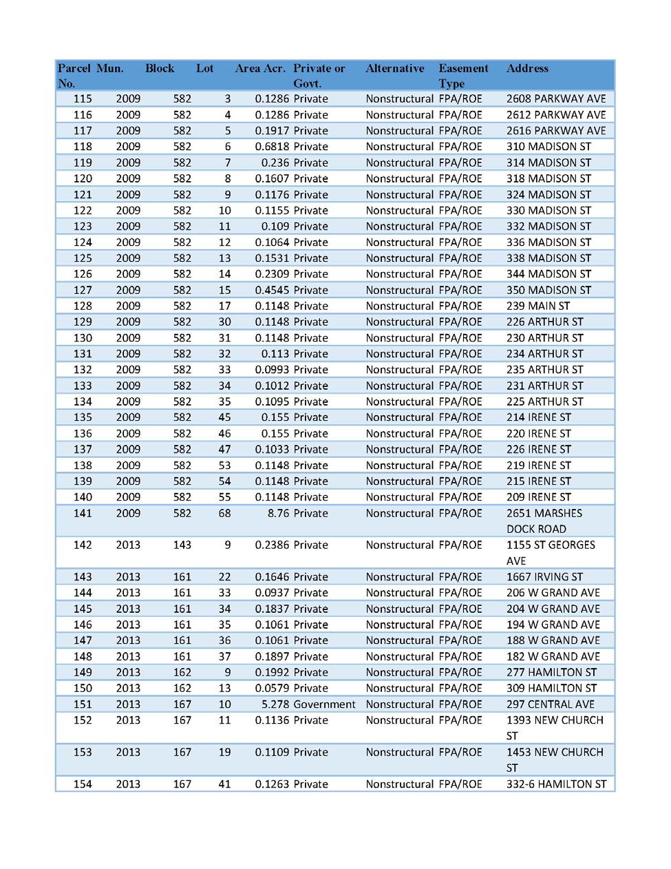
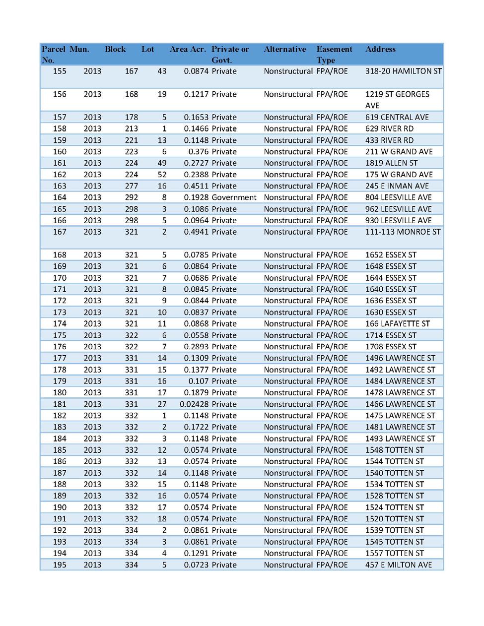
7 c. Required Lands, Easements, and Rights-of-Way (LERR): The total LER required in support of the Project is approximately acres; approximately 2.10 acres required in permanent easements, approximately 2.00 acres required in temporary easements and approximately acres in nonstructural floodproofing agreements. The Project impacts approximately 204 parcels, impacting approximately 189 private owners and 15 public owners. In some instances, more than one estate would need to be obtained over the lands of an owner. The recommended minimum real estate interest and standard estates to be acquired are as follows: I. Flood Protection Levee Easement (Standard Estate No. 9)- Approximately 2.10 acres (impacting 18 parcels; 12 privately-owned and 6 publicly-owned) are required for the construction, operation and maintenance of the Segment D levee/floodwall system. II. Temporary Work Area Easement (Standard Estate No. 15)- Approximately 2.00 acres (impacting 20 parcels; 13 privately-owned and 7 publicly-owned) are required for staging/work area purposes. The proposed temporary work areas are typically adjacent to land to be acquired for Project construction and typically affect the same ownerships. The duration required for temporary work area easements will be three years. III. Nonstructural Floodproofing Agreement- Approximately acres (impacting 166 parcels, 164 private and 2 public) are required to construct all voluntary nonstructural improvements. The nonstructural floodproofing agreement will include a right of entry for construction to implement the floodproofing features. 2
8 IV. LER Summary: The impacted parcels and LER to be acquired are provided in Exhibit B and the recommended standard estate language in Exhibit C herein. The following chart summarizes the required LER for the Project: Required Interest Required Acres Acres Below the MHWM Number of Parcels Private Public Number of Owners Private Public Acquisition Cost Flood Protection ±2.10 Levee Easement $543,856 Temporary Work ±2.00 Area Easement $68,594 Nonstructural Floodproofing Agreement ± $0 Total: ± ± $612,450 An appraisal cost estimate dated 14 September 2016 was completed by the Nashville District. The total estimated cost for the required LER is $612,450 (including a 15% contingency therein). The effective date of this value is 14 September Land, Easements, and Rights-of-Way (LER) Owned by the Non-Federal Sponsor The Sponsor owns no LER required for the construction, operation, and maintenance for the project. 4. Non-Standard Estates There are currently no proposed non-standard estates required as part of the LER for the Project. 5. Existing Federal Projects The Corps completed construction of a flood risk management project within the City of Rahway on 31 August The project consists of 2,040 feet of protective levee, 1,740 feet of closure levee and one wall, two aluminum stop log structures, two 40 cubic feet per second pump stations, miscellaneous interior drainage facilities, land fill and road raising. After completion, the project was turned over to the City of Rahway for ownership and operation and maintenance. There is no known overlap in LER requirements for this project. 3
9 6. Federally-Owned Land There are no known federally-owned lands included in the LER required for the Project. 7. Navigational Servitude 8. Maps None of land required for the Project lies below the mean high water line. The Project real estate maps are provided in Exhibits A herein. 9. Induce Flooding No induced flooding is anticipated as a result of the Project. 10. Baseline Cost Estimate for Real Estate An itemized BCERE is provided in Exhibit D in Micro-Computer Aided Cost Estimating System (MCACES) format with estimated real estate costs. If approved, the Project will be cost-shared (35% - 65%) with the Sponsor utilizing funds provided in P.L As of this report, no reimbursable real estate acquisition related expenses have been incurred by the Sponsor. Any future documented real estate acquisition related expenses incurred by the Sponsor will be fully reimbursed at the cost-shared amount. The Sponsor will not be credited for any cost associated with acquiring publicly-owned lands. The following is a summary of the Project s estimated real estate costs: Incidental Cost Cost Total Non-Federal $1,374,666 Federal $379,308 Subtotal: $1,753,974 Acquisition Cost Non-Federal $612,450 Federal $0 Subtotal: $612, % Contingency (less Land Payments) $350,795 Total Lands and Damages $2,717,219 A 20% contingency was allocated to the overall real estate costs, less Land Payments ($612,450) shown in line item 01B1 of the BCERE because a contingency has already factored into the value. 4
10 11. Compliance with Public Law The USACE does not anticipate the Project resulting in the displacement of any persons under Public Law , the Uniform Relocation Assistance and Real Property Acquisition Policies Act of 1970, (hereinafter P.L ). In the event the Project causes the displacement of qualified persons under P.L , the USACE will comply with the Act and the regulations promulgated thereunder. Minerals and Timber There are no present or anticipated mineral activities or timber harvesting within the LER required for the Project. 12. Land Acquisition Experience and Ability of the Local Sponsor The Sponsor maintains the legal and professional capability and experience to acquire the LER in support of the Project. The Sponsor has condemnation authority and other applicable authorities that may apply if necessary to support acquisition measures. The Sponsor has successfully acquired the real estate for the Sea Bright to Manasquan Inlet Project, the Long Branch Project, the Asbury Park Project, and is currently the non-federal Sponsor for the Port Monmouth Project. The Non-Federal Sponsor Capability Assessment Checklist is attached as Exhibit E herein. 13. Zoning No application or enactment of local zoning ordinances is anticipated in lieu of, or to facilitate, the acquisition of LER in connection with the Project. 14. Schedule of Acquisition Milestone Date PPA Execution April 2018 Sponsor s Notice to Proceed with Acquisition December 2018 Authorization for Entry for Construction January 2020 Certification of Real Estate February 2020 Construction Complete July Facility / Utility Relocations The Project does not include and facility relocations. 5
11 16. Hazardous, Toxic and Radioactive Waste (HTRW) There are no known contaminants or HTRW issues associates with the LER required for the Project. 17. Project Support Local officials and residents appear to be supportive of the Project. No opposition has been expressed by public or private persons or organizations on the implementation of the proposed Project. However, there is potential resistance from owners who are adversely impacted by the project. 18. Notification to Non-Federal Sponsor A formal written notification of the risks (as outlined in paragraph 12-31, Chapter 12, ER , Real Estate Handbook, 20 Nov 85) associated with acquiring the LER for this project will be provided prior to the full execution of the Project Partnership Agreement (PPA). 19. Other Issues a. There are no known historical sites within and or adjacent to the LER required for the project. 20. Points of Contact The points of contact for this real estate plan is the undersigned at (917) ( Noreen.D.Dresser@usace.army.mil) or the Real Estate Project Delivery Team member Realty Specialist Erica Labeste at (917) ( Erica.A.Labeste@usace.army.mil). 21. Recommendations This REP has been prepared in accordance with Chapter 12, ER , Real Estate Handbook, 20 Nov 85. It is recommended that this report be approved. NOREEN DEAN DRESSER Chief, Real Estate Division Real Estate Contracting Officer 6
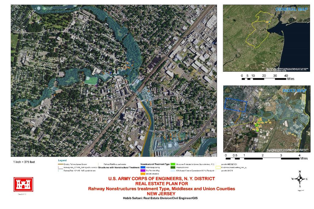
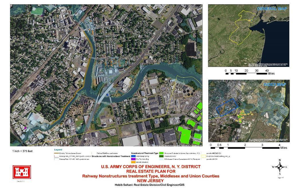
12 EXHIBIT A REAL ESTATE MAPS
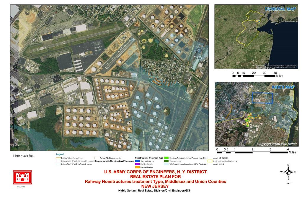
13
14
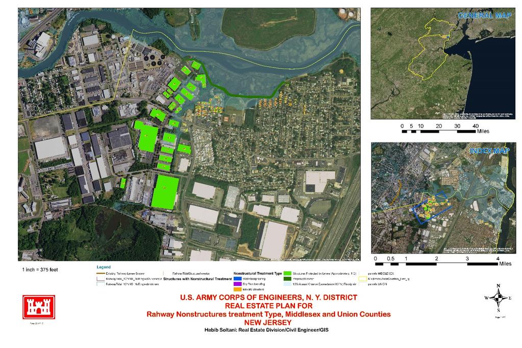
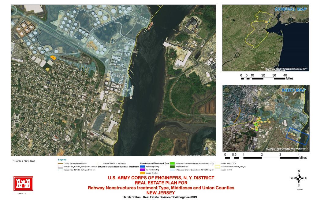
15
16 EXHIBIT B LER TO BE ACQUIRED
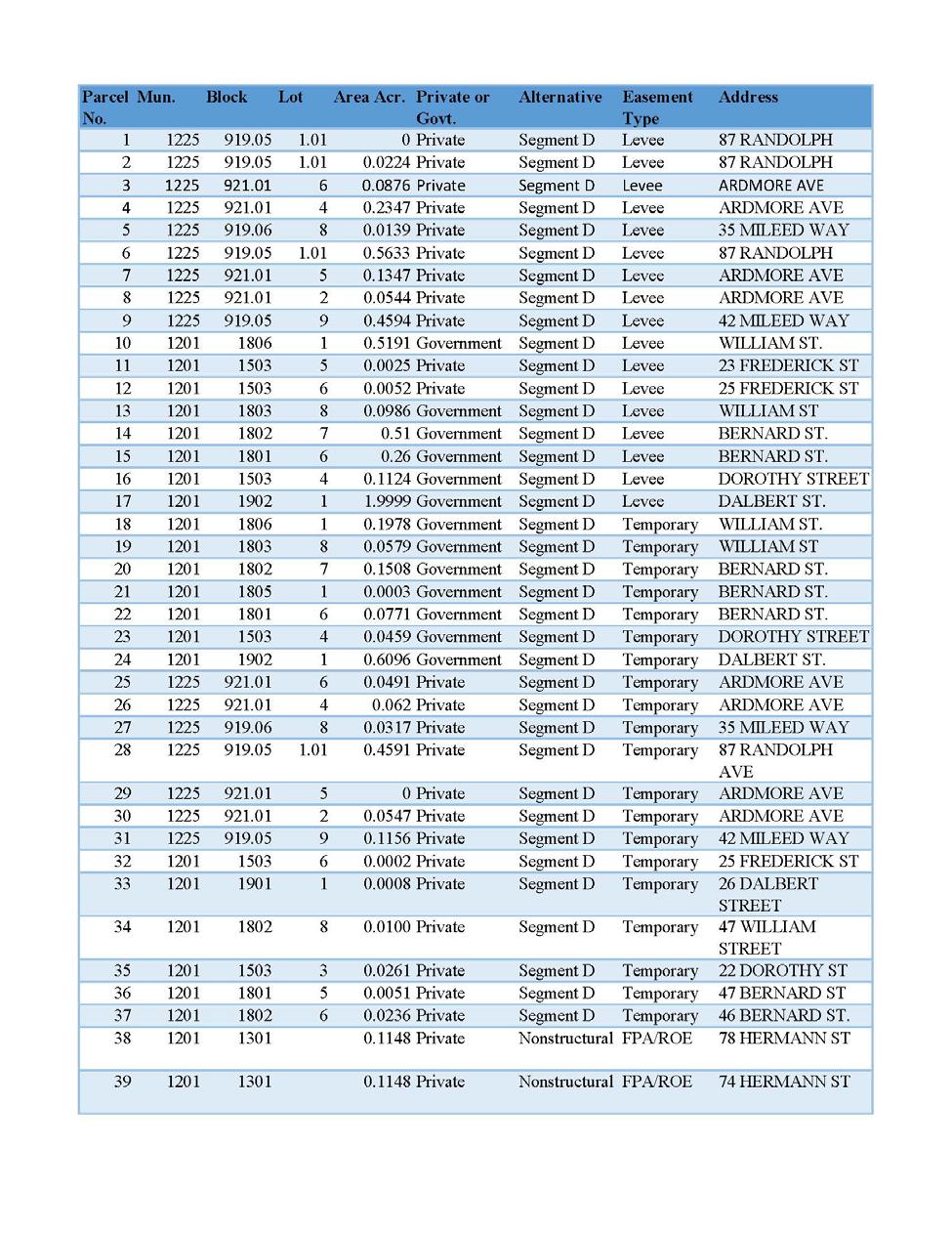
17
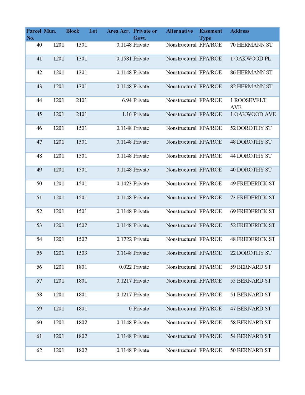
18
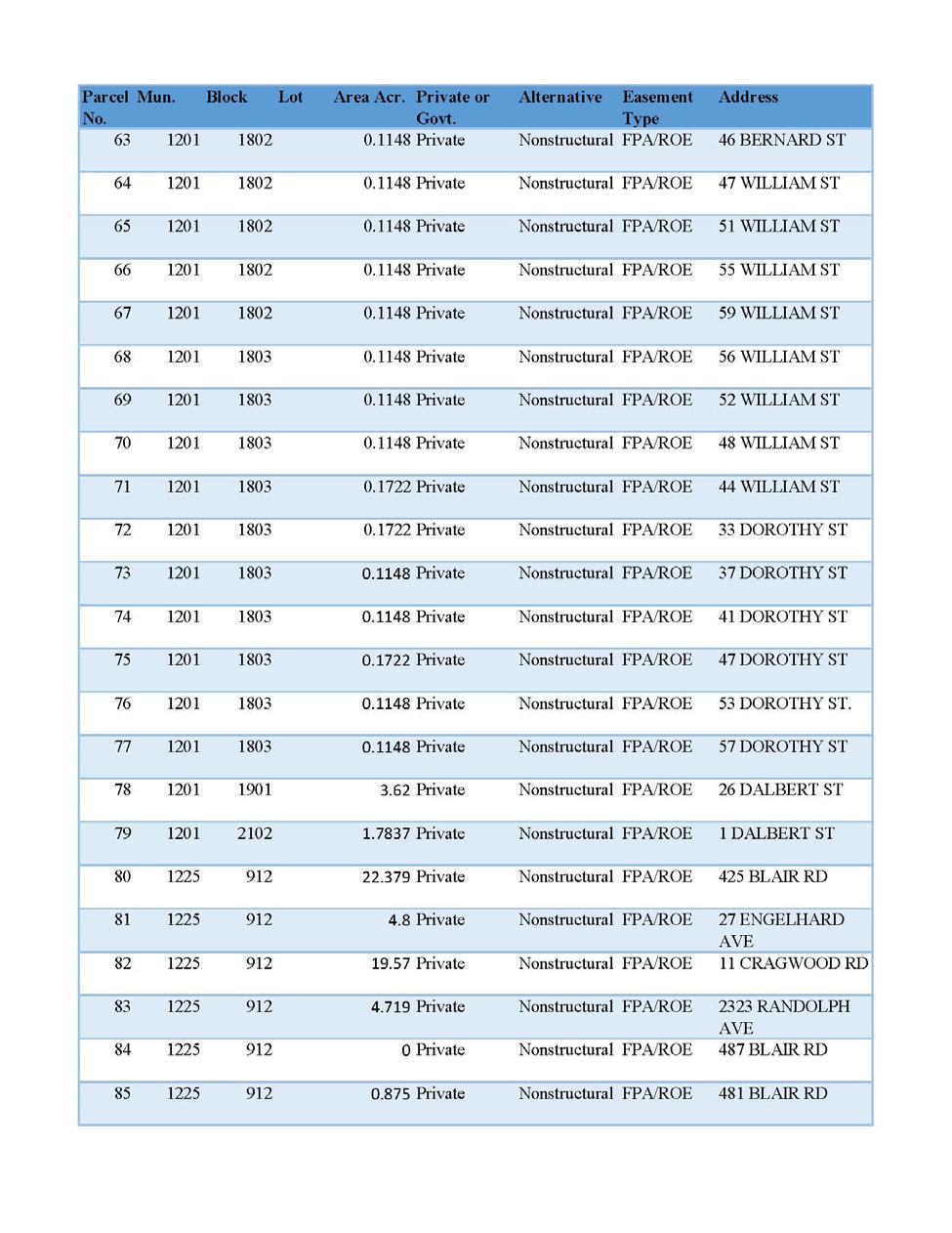
19

20
21
22

23 EXHIBIT C ESTATES
24 1. FEE (STANDARD ESTATE No. 1): The fee simple title to the land as described in Schedule A, subject, however, to existing easements for public roads and highways, public utilities, railroads and pipelines. 2. FLOOD PROTECTION LEVEE EASEMENT (STANDARD ESTATE No. 9): A perpetual and assignable right and easement in the land described in Schedule A to construct, maintain, repair, operate, patrol and replace a flood protection levee and floodwall, including all appurtenances thereto; reserving, however, to the landowners, their heirs and assigns, all such rights and privileges in the land as may be used without interfering with or abridging the rights and easement hereby acquired; subject, however, to existing easements for public roads and highways, public utilities, railroads and pipelines. 3. TEMPORARY WORK AREA EASEMENT (STANDARD ESTATE No. 15): A temporary easement and right-of-way in, on, over and across the lands described in Schedule A, for a period not to exceed [as required for each phase] beginning with date possession of the land is granted to the United States, for use by the United States, its representatives, agents, and contractors as a work area, including the right to move, store and remove equipment and supplies, and erect and remove temporary structures on the land and to perform any other work necessary and incident to the construction of the Raritan Bay and Sandy Hook Bay, Union Beach Hurricane & Storm Damage Reduction Project, together with the right to trim, cut, fell and remove therefrom all trees, underbrush, obstructions, and any other vegetation, structures, or obstacles within the limits of the right-of-way; reserving, however, to the landowners, their heirs and assigns, all such rights and privileges as may be used without interfering with or abridging the rights and easement hereby acquired; subject, however, to existing easements for public roads and highways, public utilities, railroads and pipelines.
25 4. NONSTRUCTURAL FLOODPROOFING AGREEMENT Floodproofing Agreement TRACT NO. [TRACT] RAHWAY RIVER (TIDAL) BASIN NONSTRUCTURAL COASTAL STORM RISK MANAGEMENT PROJECT WHEREAS, pursuant to Public Law (Title II, Section 202, of the Energy and Water Development Appropriation Act, 1981), as amended, and pursuant to the provisions of the Project Partnership Agreement (hereinafter referred to as the "PPA") dated [DATE] between the United States of America (hereinafter sometimes referred to as the "Government") and the Non-Federal Sponsor, New Jersey Department of Environmental Protection (hereinafter sometimes referred to as the "NJDEP"), has undertaken the implementation of the Rahway River (Tidal) Basin Nonstructural Coastal Storm Risk Management Project (hereinafter sometimes referred to as the "Project"); WHEREAS, implementation of the Project includes, inter alia, the floodproofing of certain structures so that the habitable floors thereof are raised to levels or protected by other means in such a manner which will protect the structures from certain flooding to the greater extent practicable by allowing the free movement of floodwater beneath and around the structures; WHEREAS, pursuant to the PPA, the NJDEP has undertaken floodproofing and acquisitions of interests in land for and on behalf of the County;
26 WHEREAS, [PROPERTY OWNER]; (hereinafter sometimes referred to as the "Owner"), is the Owners of a certain parcel of land identified by the NJDEP as Tract No. [TRACT], and being the same land as that described in a deed from [ACQURIING TRANSACTION DESCRIPTION], which existing structure can and shall be floodproofed in compliance with this agreement and; WHEREAS, it is the desire of the Owner to participate in and receive the benefits of the Project; NOW, THEREFORE, THIS AGREEMENT AND GRANT made and entered into by and between [OWNER]; and the NJDEP, as aforesaid; WITNESSETH, that for and in consideration of the premises and the mutual agreements and covenants hereinafter set forth; 1. The NJDEP, in conjunction with the Government, hereby agrees to floodproof the subject structure through elevation of the structure. The Owner shall permit entry upon the property by an authorized Government contractor, and permit said contractor to modify the structure consistent with contractor design to be developed. The Owner shall further permit an inspection or inspections of the floodproofing work by the NJDEP, its contractors, assigns or representatives upon completion of the work, and/or at any time during the work's progress, to ensure that the work is acceptable to the NJDEP and has been satisfactorily performed to meet the Project's criteria as to design, construction, and protection. Provided, further, that the floodproofed structure shall not be located within the regulatory floodway. Provided, further, that, should the Owner incur any cost in excess of said amount, that cost shall be borne by the Owner unless such additional amount
27 is expressly approved in writing by the Government as necessary for the purposes of flood damage reduction. 3. The Owner hereby agrees that the Owner shall not convey to any third party any interest in and to said land and the structures or create any liens thereon prior to completion of said floodproofing work and recordation of this Agreement by the Government in the land records of [COUNTY NAME] County, New Jersey, without the prior written approval of the Government. 4. The Owner hereby acknowledges that the Government has made no warranties or guarantees whatsoever in connection with the Contractor or with the Contractor's ability to satisfactorily perform the work; and, that, as between the Government and the Owner, the Owner is solely responsible to arrange for the Contractor's satisfactory completion of the work in accordance herewith. 5. Further, that for and in the consideration aforesaid, the receipt and sufficiency of which are hereby acknowledged, the Owner, for herself and her heirs and assigns, do hereby GRANT, unto the NJDEP, and its assigns, the perpetual right, power, and privilege of access to said land and any structures thereon at all reasonable times considered necessary by the NJDEP, its contractors, assigns or representatives to ensure that this Agreement, its covenants and restrictions, and the intents and purposes of the project are being complied with by the Owner, for herself and her heirs and assigns.
28 6. The Owner, for herself and her heirs and assigns, hereby covenant and warrant to the NJDEP, and to its assigns forever, and agree, that no construction, alteration, or placement of structures of any kind or nature whatsoever on said land shall take place unless the lowest floor thereof to be used for human habitation, commercial or business purposes is elevated above [DETERMINED ELEVATION] feet mean sea level, and this restriction also prohibits the placement of water damageable material of any kind below the stated elevation of [DETERMINED ELEVATION] mean sea level, and any use of materials below this elevation must meet the requirement of Flood Resistant Material as defined in the Federal Emergency Management Agency s (FEMA) FIA-TB-2(4/93)(Technical Bulletin 2-93) this restriction and requirement shall be specifically included in every instrument subsequent hereto conveying title to any interest in said land or structures thereon. 7. The Owner, for herself and her heirs and assigns, hereby covenant, warrant, and agree she will forever hold and save harmless and blameless the Government and the NJDEP, and its assigns, from any damages or injuries resulting either directly or indirectly from any floodproofing work and any flooding of said land or of the floodproofed structure. 8. The Owner, for herself and her heirs and assigns, recognize and agree that the grant hereby made to the NJDEP, and the covenants and restrictions herein, in connection with the Rahway (Tidal) Basin Nonstructural Coastal Storm Risk Management Project, are necessary and appropriate to ensure the purposes of said Project, namely, as authorized by Section 202 of the Water Resources and Development Act of 1981, Public Law , as amended, to afford a level of protection against flooding at least sufficient to prevent any future losses from the likelihood of
29 flooding as [LEVEL OF PROTECTION], whichever is greater; and, that for those purposes the NJDEP, and its assigns, shall forever have the right unchallenged by the Owner, and by the Owner s heirs and assigns, to seek legal enforcement of all of the provisions contained herein, it being the intentions of the parties that said provisions shall attach to and run with the land forever. 9. It is further provided that the obligations of the Government herein are contingent upon the Owner obtaining, as may be acceptable to the Government, the consent of any lienholder or tenants to the terms of this Agreement and obtaining from any lienholder or tenants waivers, releases, and/or subordinations of her rights in the premises to the extent necessary to accomplish the work and covenants and restrictions herein, as may be required by the Government. IN WITNESS WHEREOF, the parties have executed this Agreement and Deed effective as of the date of acceptance hereof by the New Jersey Department of Environmental Protection. [OWNER NAME] Owner [OWNER NAME], Owner
30 ACKNOWLEDGEMENT STATE OF COUNTY OF The foregoing instrument was acknowledged before me this day of, 2017, by [OWNER NAME] and [OWNER NAME]. NOTARY PUBLIC My Commission Expires: ACCEPTED: New Jersey Department of Environmental Protection By: [TITLE] DATE
31 ACKNOWLEDGEMENT STATE OF COUNTY OF On this day of, [YEAR], the undersigned officer, personally appeared, [TITLE], New Jersey Department of Environmental Protection, known to me to be the person described in the foregoing Agreement and Deed, and acknowledged that he executed the same in the capacity therein stated and for the purposes therein contained. IN WITNESS WHEREOF, I hereunto set my hand and official seal. (Seal) NOTARY PUBLIC My Commission Expires: THIS INSTRUMENT WAS PREPARED BY: [NAME], Attorney [ADDRESS 1] [ADDRESS 2]
32 EXHIBIT D BASELINE COST ESTIMATE FOR REAL ESTATE
33 TOTAL PROJECT REAL ESTATE COSTS (Cost-Shared 65%/35%) Non-Federal Federal Project Cost RAHWAY TIDAL (ALTERNATIVE 4) Cost Summary: Incidental Costs (01A) $1,374,666 $379,308 $1,753,974 Real Estate Acquisition Costs (01B) $612,450 $0 $612,450 Subtotal: $1,987,116 $379,308 $2,366,424 20% Contingency, Less Land Payments (01B1) $274,933 $75,862 $350, LANDS AND DAMAGES $2,262,049 $455,170 $2,717,219 01A INCIDENTAL COSTS $1,374,666 $379,308 $1,753,974 01A1 Acquisition (Admin Costs) $150,000 $75,000 01A1A By Government (Gov't) $75,000 01A1B By Non-Federal Sponsor (NFS) $150,000 01A1C By Gov't on behalf of NFS 01A2 Survey $90,000 $9,000 01A2A By Gov't (In-house) 01A2B By Gov't (Contract) 01A2C By NFS $90,000 01A2D By Gov't on behalf of NFS 01A2E Review of NFS $9,000 01A3 Appraisal $176,000 $61,600 01A3A By Gov't (In-house) 01A3B By Gov't (Contract) 01A3C By NFS $176,000 01A3D By Gov't on behalf of NFS 01A3E Review of NFS $61,600 01A4 Title Services $424,000 $12,000 01A4A By Gov't (Contract) 01A4B By NFS $424,000 01A4C By Gov't on behalf of NFS 01A4D Review of NFS $12,000 01A5 Other Professional Services $216,000 $0 01A5A By the Gov't 01A5B By the NFS $216,000 01A5C By Gov't on behzlf of NFS
34 TOTAL PROJECT REAL ESTATE COSTS (Cost-Shared 65%/35%) Non-Federal Federal Project Cost 01A5D Review of NFS 01A6 01A6A Closing Cost (4% of Land Payments- 01C1) $24,498 $0 By Gov't 01A6B By NFS $24,498 01A6C By Gov't on behalf of NFS 01A7 PL Assistance $294,168 $147,084 01A7A By Government 01A7B By NFS $294,168 01A7C By Gov't on behalf of NFS 01A7D Review of NFS $147,084 01A8 Audit $0 $74,624 01A8A By Gov't $74,624 01A9B By NFS 01B REAL ESTATE ACQUISITION COSTS $612,450 $0 $612,450 01B1 Land Payments $612,450 $0 01B1A By Government 01B1B By NFS $612,450 01B1C By Gov't on behalf of NFS 01B2 Damage Payments $0 $0 01B2A By Government 01C2B By NFS 01C2C By Gov't on behalf of NFS 01B3 PL Payment $0 $0 01B3A By Government 01B3B By NFS $0 01B3C By Gov't on behalf of NFS
35 EXHIBIT E NON-FEDERAL SPONSOR CAPABILITY ASSESSMENT CHECKLIST
36 ASSESSMENT OF NON-FEDERAL PROJECT PARTNERS S REAL ESTATE ACQUISITION CAPABILITY RAHWAY RIVER (TIDAL) BASIN, NEW JERSEY COASTAL STORM RISK MANAGEMENT FEASIBILITY STUDY I. Legal Authority. a. Does the sponsor have legal authority to acquire and hold title to real property for project purposes? Yes. b. Does the sponsor have the power of eminent domain for this project? Yes. c. Does the sponsor have quick-take authority for this project? Yes. d. Are any of the lands/interests in land required for the project located outside the sponsor s political boundary? No. e. Are any of the lands/interests in land required for the project owned by an entity whose property the sponsor cannot condemn? No. II. Human Resource Requirements. a. Will the sponsor s in-house staff require training to become familiar with the real estate requirements of Federal projects including P.L , as amended? No. b. If the answer to II.a is yes, has a reasonable plan been developed to provide such training? c. Does the sponsor s in-house staff have sufficient real estate acquisition experience to meet its responsibilities for the project? Yes. d. Is the sponsor s projected in-house staffing level sufficient considering its other workload, if any, and the project schedule? Yes. e. Can the sponsor obtain contractor support, if required in a timely fashion? Yes. f. Will the sponsor likely request USACE assistance in acquiring real estate? No. III. Other Project Variables. a. Will the sponsor s staff be located within reasonable proximity to the project site? Yes. b. Has the sponsor approved the project/real estate schedule/milestones? Yes.
37 IV. Overall Assessment. a. Has the sponsor performed satisfactorily on other USACE projects? Yes. b. With regard to this project, the sponsor is anticipated to be: highly capable/fully capable/moderately capable/marginally capable/insufficiently capable. If sponsor is believed to be insufficiently capable, provide explanation. Highly Capable. V. Coordination. a. Has this assessment been coordinated with the sponsor? Yes. b. Does the sponsor concur with this assessment? Sponsor has not responded to this form. Reviewed and approved by: Noreen Dean Dresser Chief of Real Estate Division Real Estate Contracting Officer New York District Corps of Engineers
Draft Appendix E. Real Estate Plan. Rahway River Basin, New Jersey Flood Risk Management Feasibility Study. November 2016
 Draft Appendix E Real Estate Plan Rahway River Basin, New Jersey Flood Risk Management Feasibility Study November 2016 New Jersey Department of Environmental Protection U.S. Army Corps of Engineers New
Appendix D: Real Estate
 Shrewsbury River Basin, Sea Bright, New Jersey Coastal Storm Risk Management Feasibility Study Draft Integrated Feasibility Report & Environmental Assessment Appendix D: Real Estate Shrewsbury River Basin,
JANUARY 2016 MAMARONECK & SHELDRAKE RIVERS NEW YORK FLOOD RISK MANAGEMENT GENERAL REEVALUATION REPORT FOR THE VILLAGE OF MAMARONECK APPENDIX E
 U.S. Army Corps of Engineers New York District MAMARONECK & SHELDRAKE RIVERS NEW YORK FLOOD RISK MANAGEMENT GENERAL REEVALUATION REPORT FOR THE VILLAGE OF MAMARONECK JANUARY 2016 APPENDIX E REAL ESTATE
DRAFT INTEGRATED FEASIBILITY REPORT AND ENVIRONMENTAL ASSESSMENT
 APPENDIX E REAL ESTATE PLAN MT. SINAI MEDICAL CENTER, CONTINUTING AUTHORITIES PROGRAM (CAP) SECTION 14, PROJECT DRAFT INTEGRATED FEASIBILITY REPORT AND ENVIRONMENTAL ASSESSMENT September 2016 DRAFT APPENDIX
HASHAMOMUCK COVE, SOUTHOLD, NEW YORK COASTAL STORM RISK MANAGEMENT FEASIBILITY STUDY APPENDIX F REAL ESTATE PLAN
 U.S. Army Corps of Engineers New York District HASHAMOMUCK COVE, SOUTHOLD, NEW YORK COASTAL STORM RISK MANAGEMENT FEASIBILITY STUDY APPENDIX F REAL ESTATE PLAN AUGUST 2016 HASHAMOMUCK COVE, SOUTHOLD, NEW
Appendix B Real Estate Plan
 Appendix B Real Estate Plan B-1 REAL ESTATE PLAN Prepared for U.S. Army Corps of Engineers Southwestern Division Little Rock District As of May 1, 2013 Prepared by Ronald Bridges Real Estate Division ANY
EDISTO BEACH COASTAL STORM DAMAGE REDUCTION GENERAL INVESTIGATION STUDY APPENDIX K REAL ESTATE
 EDISTO BEACH COASTAL STORM DAMAGE REDUCTION GENERAL INVESTIGATION STUDY APPENDIX K REAL ESTATE Table of Contents REAL ESTATE APPENDIX... I... i SECTION 1. THE REAL ESTATE REPORT... 1 1.1 Statement of Purpose...
Appendix B Draft Real Estate Plan
 Appendix B Draft Real Estate Plan B-1 REAL ESTATE PLAN Prepared for U.S. Army Corps of Engineers Southwestern Division Little Rock District As of December 3, 2012 Prepared by Ronald Bridges Real Estate
Appendix H: Real Estate Plan
 APPENDIX H Spring Creek North Ecosystem Restoration Feasibility Study Appendix H: Real Estate Plan New York District U.S. Army Corps of Engineers October 2016 Revised: 13 April 2017 Spring Creek North
MAMARONECK AND SHELDRAKE RIVER FLOOD DAMAGE REDUCTION PROJECT MAMARONECK, NEW YORK APPENDIX E REAL ESTATE PLAN
 U.S. Army Corps of Engineers New York District MAMARONECK AND SHELDRAKE RIVER FLOOD DAMAGE REDUCTION PROJECT MAMARONECK, NEW YORK APPENDIX E REAL ESTATE PLAN April 2017 MAMARONECK AND SHELDRAKE RIVER FLOOD
Draft Continuing Authorities Program Section 1135 Detailed Project Report and Integrated Environmental Assessment
 Appendix G Real Estate Shorty s Island / Meander Reach Ecosystem Restoration Kootenai River, Idaho Draft Continuing Authorities Program Section 1135 Detailed Project Report and Integrated Environmental
Delaware River Basin Comprehensive Flood Risk Management Interim Feasibility Study and Integrated Environmental Assessment for New Jersey
 Delaware River Basin Comprehensive Flood Risk Management Interim Feasibility Study and Integrated Environmental Assessment for New Jersey Flooding in the Study Area, April 2005 June 2015 APPENDIX F: Draft
Appendix G. Non-Federal Letters of Support and Draft Real Estate Plan
 Appendix G Non-Federal Letters of Support and Draft Real Estate Plan REAL ESTATE PLAN UPPER DELAWARE RIVER WATERSHED FEASABILITY STUDY LIVINGSTON MANOR, NEW YORK 1. GENERAL 2. REAL ESTATE REQUIREMENTS
DRAFT East Rockaway Inlet to Rockaway Inlet and Jamaica Bay. Atlantic Coast of New York
 DRAFT East Rockaway Inlet to Rockaway Inlet and Jamaica Bay Atlantic Coast of New York APPENDIX E REAL ESTATE PLAN AUGUST 2018 East Rockaway Inlet to Rockaway Inlet and Jamaica Bay Reformulation Study
WEST SHORE LAKE PONTCHARTRAIN HURRICANE AND STORM DAMAGE RISK REDUCTION STUDY INTEGRATED DRAFT FEASIBILITY REPORT AND ENVIRONMENTAL IMPACT STATEMENT
 WEST SHORE LAKE PONTCHARTRAIN HURRICANE AND STORM DAMAGE RISK REDUCTION STUDY INTEGRATED DRAFT FEASIBILITY REPORT AND ENVIRONMENTAL IMPACT STATEMENT REAL ESTATE PLAN APPENDIX C Annex A: Project Maps Annex
APPENDIX M. Real Estate Plan
 APPENDIX M Real Estate Plan Poplar Island Environmental Restoration Project September 2005 General Reevaluation Report (GRR) and Supplemental Environmental Impact Statement (SEIS) REAL ESTATE PLAN (REP)
BEACH STORM DAMAGE REDUCTION EASEMENT
 STATE OF FLORIDA COUNTY OF WALTON WALTON COUNTY, FL HURRICANE & STORM DAMAGE REDUCTION PROJECT FILE/REACH#: PARCEL ID#: BEACH STORM DAMAGE REDUCTION EASEMENT KNOW ALL MEN BY THESE PRESENTS, that for and
APPENDIX D - REAL ESTATE
 APPENDIX D - REAL ESTATE 1. Purpose Real Estate Plan For Feasibility Study For Lake Lou Yaeger Section 206 Aquatic Ecosystem Restoration Continuing Authorities Project Feasibility Study This report is
APPENDIX F REAL ESTATE
 APPENDIX F REAL ESTATE Real Estate Plan For Broward County, Florida Shore Protection Project Segments II and III General Reevaluation Report 1. Statement Of Purpose. The Real Estate Plan is tentative in
Appendix C. Real Estate. Brazos Island Harbor, Texas Channel Improvement Project Cameron County, Texas
 Appendix C Real Estate Brazos Island Harbor, Texas Channel Improvement Project Cameron County, Texas U.S. Army Corps of Engineers, Galveston District 2000 Fort Point Road Galveston, Texas 77550 December
Draft Integrated Feasibility Report and Environmental Assessment and Draft Finding of No Significant Impact
 Draft Integrated Feasibility Report and Environmental Assessment and Draft Finding of No Significant Impact APPENDIX F: REAL ESTATE Whittier, Alaska June 2018 Pacific Ocean Division DRAFT REAL ESTATE
INDIANA HARBOR AND CANAL CONFINED DISPOSAL FACILITY EAST CHICAGO, INDIANA
 INDIANA HARBOR AND CANAL CONFINED DISPOSAL FACILITY EAST CHICAGO, INDIANA APPENDIX J REAL ESTATE Acquisition Branch Real Estate Division Chicago District U.S. Army Corps of Engineers APPENDIX J REAL ESTATE
REAL ESTATE PLAN APPENDIX G
 Pacific Ocean Division REAL ESTATE PLAN APPENDIX G Alaska District UNALASKA (DUTCH HARBOR) CHANNELS UNALASKA, ALASKA Real Estate Division Alaska District U.S. Army Corps of Engineers TABLE OF CONTENTS
APPENDIX H. Real Estate Plan
 INTEGRATED FEASIBILITY REPORT AND ENVIRONMENTAL IMPACT STATEMENT COASTAL STORM DAMAGE REDUCTION BOGUE BANKS, CARTERET COUNTY NORTH CAROLINA APPENDIX H Real Estate Plan US Army Corps of Engineers Wilmington
Draft Environmental Impact Statement (EIS)/Environmental Impact Report (EIR) APPENDIX H Real Estate Cost
/Environmental Impact Report (EIR) APPENDIX H Real Estate Cost") Draft Environmental Impact Statement (EIS)/Environmental Impact Report (EIR) APPENDIX H Real Estate Cost US Army Corps of Engineers Corte Madera Creek Flood Risk Management Project October 2018 APPENDIX
Draft Environmental Impact Statement (EIS)/Environmental Impact Report (EIR) APPENDIX H Real Estate Cost US Army Corps of Engineers Corte Madera Creek Flood Risk Management Project October 2018 APPENDIX
Downtown Montauk Stabilization Project. Real Estate Plan Appendix
 Downtown Montauk Stabilization Project Real Estate Plan Appendix October 2014 Table of Contents Page 1. Introduction and General Information 1 a. Authority 2 b. History 2 c. Location Project Study Area
Appendix K. Real Estate Plan
 Appendix K. Real Estate Plan REAL ESTATE PLAN DELTA ISLANDS AND LEVEES FEASIBILITY STUDY (DELTA STUDY) 20 June 2018 PREPARED BY THE SACRAMENTO DISTRICT U.S. ARMY CORPS OF ENGINEERS 1 TABLE OF CONTENTS
City of East Providence
 City of East Providence 145 TAUNTON AVENUE, EAST PROVIDENCE STATE OF RHODE ISLAND AND PROVIDENCE PLANTATIONS 02914-4505 TEL. (401) 435-7521 FAX (401) 438-1719 TDD (401) 431-1633 CITY MANAGER PETER GRACZYKOWSKI
AGREEMENT TO ACQUIRE LANDS BETWEEN THE DEPARTMENT OF THE ARMY ST. PAUL DISTRICT, CORPS OF ENGINEERS AND. THE CITY OF City, State
 AGREEMENT TO ACQUIRE LANDS BETWEEN THE DEPARTMENT OF THE ARMY ST. PAUL DISTRICT, CORPS OF ENGINEERS AND THE CITY OF City, State FOR CONDEMNATION ON BEHALF OF THE SPONSOR BY THE CORPS OF ENGINEERS FOR THE
APPENDIX E REAL ESTATE PLAN
 APPENDIX E REAL ESTATE PLAN REAL ESTATE PLAN VILLAGE OF BARBOURSVILLE, WATER STREET, STREAMBANK PROTECTION PROJECT CABELL COUNTY, WEST VIRGINIA SECTION 14 1. Authority/Purpose This Real Estate Plan is
Final General Reevaluation Report and Final Environmental Impact Statement. Hurricane Protection and Beach Erosion Control
 Final General Reevaluation Report and Final Environmental Impact Statement on Hurricane Protection and Beach Erosion Control WEST ONSLOW BEACH AND NEW RIVER INLET (TOPSAIL BEACH), NORTH CAROLINA Appendix
Dredged Material Management Plan Atlantic Intracoastal Waterway Port Royal Sound, South Carolina to Cumberland Sound, Georgia November 2015
 Dredged Material Management Plan Atlantic Intracoastal Waterway Port Royal Sound, South Carolina to Cumberland Sound, Georgia November 2015 Appendix H: Real Estate US Army Corps of Engineers South Atlantic
APPENDIX D REAL ESTATE PLAN
 APPENDIX D REAL ESTATE PLAN APPENDIX D REAL ESTATE PLAN TABLE OF CONTENTS 1. STATEMENT OF PURPOSE 2. REFERENCES 3. AUTHORIZATION 4. BACKGROUND 5. LOCATION 6. REAL ESTATE REQUIREMENTS 7. OWNERSHIP OF REAL
APPENDIX G REAL ESTATE
 BUBBLY CREEK, SOUTH BRANCH OF THE CHICAGO RIVER, ILLINOIS FEASIBILITY STUDY APPENDIX G REAL ESTATE DRAFT - NOT FOR DISTRIBUTION APRIL 2015 U.S. Army Corps of Engineers Chicago District Appendix G Real
ESCROW AGREEMENT - MAINTENANCE
 ESCROW AGREEMENT - MAINTENANCE This ESCROW AGREEMENT (the Agreement ) is made and entered into this day of,, by and between the City of O Fallon, Missouri, a Missouri municipal corporation (hereinafter
APPENDIX H REAL ESTATE REQUIREMENTS
 Malden River Ecosystem Restoration Detailed Project Report APPENDIX H REAL ESTATE REQUIREMENTS April 2007 Malden River Ecosystem Restoration Real Estate Report 1. PURPOSE: The Detailed Project Report
CHAPTER 2 RELATED DOCUMENTS AND FORMS
 CHAPTER 2 RELATED DOCUMENTS AND FORMS TABLE OF CONTENTS CHAPTER 2 RELATED DOCUMENTS AND FORMS Resolution R00- Establishing Public Improvement Design Standards Page 1 Current Plans Review & Construction
DEED AND DEDICATION FOR PUBLIC RIGHT OF WAY
 TO : BOARD OF DIRECTORS FROM : GARY PLATT, EXEC. DIRECTOR BUSINESS AND OPERATIONS SUBJECT : CITY OF STANWOOD CONSTRUCTION EASEMENT AND RIGHT-OF-WAY DEDICATION DATE : MARCH 17, 2009 TYPE : ACTION NEEDED
HUNTING BAYOU FLOOD RISK MANAGEMENT, HARRIS COUNTY, TEXAS DRAFT GENERAL REEVALUATION REPORT AND INTEGRATED ENVIRONMENTAL ASSESSMENT
 HUNTING BAYOU FLOOD RISK MANAGEMENT, HARRIS COUNTY, TEXAS DRAFT GENERAL REEVALUATION REPORT AND INTEGRATED ENVIRONMENTAL ASSESSMENT APPENDIX 6 REAL ESTATE PLAN June 2014 HARRIS COUNTY FLOOD CONTROL DISTRICT
CITY AND COUNTY OF BROOMFIELD SUBDIVISION IMPROVEMENT AGREEMENT FOR (PROPERTY NAME - ALL CAPS)
") CITY AND COUNTY OF BROOMFIELD SUBDIVISION IMPROVEMENT AGREEMENT FOR (PROPERTY NAME - ALL CAPS) THIS AGREEMENT, made and entered into this day of, 20, by and between The CITY AND COUNTY OF BROOMFIELD, a
CITY AND COUNTY OF BROOMFIELD SUBDIVISION IMPROVEMENT AGREEMENT FOR (PROPERTY NAME - ALL CAPS) THIS AGREEMENT, made and entered into this day of, 20, by and between The CITY AND COUNTY OF BROOMFIELD, a
APPENDIX C REAL ESTATE PLAN BOULEVARD RESACA, BROWNSVILLE, TX CAMERON COUNTY, TEXAS
 APPENDIX C REAL ESTATE PLAN BOULEVARD RESACA, BROWNSVILLE, TX CAMERON COUNTY, TEXAS November 19, 2016 Table of Contents Purpose... 3 Project Authority... 3 Project Location and Description... 3 Non-Federal
DECLARATION OF DRAINAGE EASEMENTS. Document No. Document Title. (Declarant) Recording Data Return Address
 Recording Data Return Address") Document No. DECLARATION OF DRAINAGE EASEMENTS Document Title (Declarant) Recording Data Return Address DOCUMENT PREPARED BY AND AFTER RECORDING RETURN TO: Parcel No. - - - - - - DECLARATION OF DRAINAGE
Document No. DECLARATION OF DRAINAGE EASEMENTS Document Title (Declarant) Recording Data Return Address DOCUMENT PREPARED BY AND AFTER RECORDING RETURN TO: Parcel No. - - - - - - DECLARATION OF DRAINAGE
STORMWATER BEST MANAGEMENT PRACTICES OPERATIONS AND MAINTENANCE AGREEMENT
 STORMWATER BEST MANAGEMENT PRACTICES OPERATIONS AND MAINTENANCE AGREEMENT THIS AGREEMENT, made and entered into this day of, 20, by and between, (hereinafter the Landowner ), and the TOWNSHIP OF HEMPFIELD,
Skagit River Flood Risk Management General Investigation Skagit County, Washington. Draft Feasibility Report and Environmental Impact Statement
 General Investigation Skagit County, Washington Draft Feasibility Report and Environmental Impact Statement May 2014 Real Estate Requirements of Selected Plan This Real Estate Plan Summary (REP) is presented
PURCHASE AND SALE AGREEMENT
 PURCHASE AND SALE AGREEMENT This Purchase and Sale Agreement (this Agreement ) made and entered into as of the day of, 2017 (the Effective Date ), by and between the Greenville County Library System (the
Appendix J. Real Estate Plan
 Appendix J Real Estate Plan Real Estate Plan Louisiana Coastal Area Near-Term Ecosystem Restoration Plan Medium Diversion at White Ditch 1. PURPOSE Title VII of the Water Resources Development Act of 2007
PIPELINE RIGHT-OF-WAY EASEMENT
 PIPELINE RIGHT-OF-WAY EASEMENT THIS RIGHT-OF-WAY EASEMENT made this day of March, 2014, by the City of Rochester Hills, a municipal corporation in the State of Michigan,, having an address at 1000 Rochester
DRAFT REAL ESTATE PLAN APPENDIX D JEFFERSON COUNTY ECOSYSTEM RESTORATION FEASIBILITY STUDY
 DRAFT REAL ESTATE PLAN APPENDIX D JEFFERSON COUNTY ECOSYSTEM RESTORATION FEASIBILITY STUDY (NOTE: This page intentionally left blank.) This Real Estate Plan has been prepared in accordance with ER 405-1-12
Stormwater Treatment Facility Maintenance Agreement
 Stormwater Treatment Facility Maintenance Agreement This Agreement made and entered into this day of, 20, by, (hereinafter referred to as Property Owner") RECITALS: WHEREAS, the Property Owner is the owner
It is necessary for the Board to adopt the attached resolution accepting the dedication of the easement.
 SOUTHAMPTON COUNTY BOARD OF SUPERVISORS Regular Session i May 28, 2013 11. ACCEPTANCE OF A SANITARY SEWER EASEMENT FROM THE COMMONWEALTH OF VIRGINIA, DEPARTMENT OF TRANSPORTATION Attached for your review
SITE LEASE. between. CITY OF WESTWOOD, KANSAS, as Site Lessor. and. SECURITY BANK OF KANSAS CITY, as Site Lessee
 Gilmore & Bell, P.C. Draft #2 March 7, 2014 SITE LEASE between CITY OF WESTWOOD, KANSAS, as Site Lessor and SECURITY BANK OF KANSAS CITY, as Site Lessee After Recording, return to: Nancy Midden Gilmore
PERMANENT DRAINAGE EASEMENT
 City Project No. Project Name: ; Tr. # Parcel No. (LLC, Corporation, Partnership) PERMANENT DRAINAGE EASEMENT THIS AGREEMENT, made and entered into this day of, 201, by and between, a, hereinafter called
AGREEMENT FOR TEMPORARY CONSTRUCTION EASEMENT AND PERMANENT SEWER UTILITY EASEMENT
 AGREEMENT FOR TEMPORARY CONSTRUCTION EASEMENT AND PERMANENT SEWER UTILITY EASEMENT This Agreement for Temporary Construction Easement and Permanent Sewer Utility Easement (hereinafter the "Agreement")
ORDINANCE NO (1123)
") ORDINANCE NO. 2013-08 (1123) ORDINANCE OF THE BOROUGH OF LAVALLLETTE, COUNTY OF OCEAN, STATE OF NEW JERSEY, AMENDING AND SUPPLEMENTING CHAPTER 31, ENTITLED FLOOD HAZARD AREAS, OF THE REVISED GENERAL ORDINANCES
ORDINANCE NO. 2013-08 (1123) ORDINANCE OF THE BOROUGH OF LAVALLLETTE, COUNTY OF OCEAN, STATE OF NEW JERSEY, AMENDING AND SUPPLEMENTING CHAPTER 31, ENTITLED FLOOD HAZARD AREAS, OF THE REVISED GENERAL ORDINANCES
DECLARATION OF RESTRICTIVE COVENANTS. THIS DECLARATION OF RESTRICTIVE COVENANTS made this day of, 200_, by ( Declarant ). RECITALS
. RECITALS") DECLARATION OF RESTRICTIVE COVENANTS THIS DECLARATION OF RESTRICTIVE COVENANTS made this day of, 200_, by ( Declarant ). RECITALS WHEREAS, Declarant is the owner of the surface of certain real property
DECLARATION OF RESTRICTIVE COVENANTS THIS DECLARATION OF RESTRICTIVE COVENANTS made this day of, 200_, by ( Declarant ). RECITALS WHEREAS, Declarant is the owner of the surface of certain real property
EASEMENT AGREEMENT. WHEREAS, Ferguson is the 100% owner of the property described on Exhibit B attached hereto (the Williams Property );
;") EASEMENT AGREEMENT THIS EASEMENT AGREEMENT ( Agreement ) is entered into as of this day of, 2016, by and between CRAIG FERGUSON ( Ferguson ), and MAMIE DAVIS and JERRY MOORE ( Davis & Moore ), whose legal
EASEMENT AGREEMENT THIS EASEMENT AGREEMENT ( Agreement ) is entered into as of this day of, 2016, by and between CRAIG FERGUSON ( Ferguson ), and MAMIE DAVIS and JERRY MOORE ( Davis & Moore ), whose legal
Stormwater Ordinance Appendix APPENDIX K EXAMPLE TAR-PAM CONVERSATION EASEMENT
 APPENDIX K EXAMPLE TAR-PAM CONVERSATION EASEMENT Tax Parcel ID # NORTH CAROLINA FRANKLIN COUNTY CONSERVATION EASEMENT Franklin County, North Carolina THIS CONSERVATION EASEMENT (this "Conservation Easement")
EXHIBIT A ENVIRONMENTAL COVENANT AND ACCESS AGREEMENT
 ENVIRONMENTAL COVENANT AND ACCESS AGREEMENT AFTER RECORDING RETURN TO: Laura Wishik, Esq. Director, Environmental Protection Section P. O. Box 94769 Seattle, WA 98124-4769 GRANTOR AND OWNER: City of Seattle
DECLARATION OF PARTY WALL RIGHTS, COVENANTS, CONDITIONS, RESTRICTIONS AND EASEMENTS
 DECLARATION OF PARTY WALL RIGHTS, COVENANTS, CONDITIONS, RESTRICTIONS AND EASEMENTS This Declaration of Party Wall Rights, Covenants, Conditions, Restrictions and Easements (the Declaration) is made this
UPPER MISSISSIPPI RIVER RESTORATION FEASIBILITY REPORT WITH INTEGRATED ENVIRONMENTAL ASSESSMENT
 UPPER MISSISSIPPI RIVER RESTORATION FEASIBILITY REPORT WITH INTEGRATED ENVIRONMENTAL ASSESSMENT McGregor Lake HABITAT REHABILITATION AND ENHANCEMENT PROJECT POOL 10, UPPER MISSISSIPPI RIVER MILE 635-634
REAL ESTATE PLAN. Final Integrated General Reevaluation Report and Supplemental Environmental Impact Statement
 REAL ESTATE PLAN Final Integrated General Reevaluation Report and Supplemental Environmental Impact Statement Mississippi River, Baton Rouge to the Gulf of Mexico Mississippi River-Gulf Outlet, Louisiana,
TOWNSHIP OF LOWER MERION Department of Public Works
 EXHIBIT B TOWNSHIP OF LOWER MERION Department of Public Works MEMORANDUM TO: Douglas S. Cleland, Township Manager FROM: Donald K. Cannon, Director of Public Works SUBJECT: 1200 Farview Road Sanitary Sewer
DEPARTMENT OF THE ARMY U.S. Army Corps of Engineers Washington, DC Regulation No May 2015
 CEMP-CR DEPARTMENT OF THE ARMY U.S. Army Corps of Engineers Washington, DC 20314-1000 ER 405-1-19 Regulation No. 405-1-19 29 May 2015 Real Estate ACQUISITION BY CONDEMNATION PROCEEDINGS 1. Purpose. Engineer
MORTGAGE. THIS INSTRUMENT ( Mortgage )
") MORTGAGE THIS INSTRUMENT ( Mortgage ) WITNESSES That and, whose address is (individually, collectively, jointly, and severally, Mortgagor ), in consideration of One Dollar ($1) and other good and valuable
MORTGAGE THIS INSTRUMENT ( Mortgage ) WITNESSES That and, whose address is (individually, collectively, jointly, and severally, Mortgagor ), in consideration of One Dollar ($1) and other good and valuable
This is a sample form for information ONLY. UTILITY INFRASTRUCTURE CONVEYANCE AND SERVICE AGREEMENT
 This is a sample form for information ONLY. A CSA will be tailored to your project at the appropriate time during the development process. Please contact the Development Services Team for additional information.
Explanation of Permanent Stormwater Management Facilities Maintenance Agreement
 Explanation of Permanent Stormwater Management Facilities Maintenance Agreement The Permanent Stormwater Management Facilities Maintenance Agreement for a site is comprised of the following elements: 1.
FEE SIMPLE OPTION AGREEMENT Ecosystem Enhancement Program SPO File Number
 STATE OF NORTH CAROLINA COUNTY OF Prepared by State Property Office Return after recording to: Blane Rice, State Property Office 1321 Mail Service Center Raleigh, NC 27699-1321 FEE SIMPLE OPTION AGREEMENT
DECLARATION OF EASEMENTS AND COST SHARING AGREEMENT
 PREPARED BY AND AFTER RECORDING RETURN TO: James Johnston, Esq. Shutts & Bowen LLP 300 S. Orange Avenue Suite 1000 Orlando, Florida 32801 Tax Parcel I.D.s: 25-21-29-0000-00-032 25-21-29-4432-00-001 DECLARATION
Southwest Coastal Louisiana Study
 REAL ESTATE PLAN Annex 1: Project Maps Annex 2: Assessment of Non-Federal Sponsor s Acquisition Capability Annex 3: Non-Material Deviation from Standard Estate Perpetual Access Easement Annex 4: Baseline
COMMERCIAL PROPERTY ASSESSED CLEAN ENERGY ( C-PACE ) AGREEMENT
 AGREEMENT") COMMERCIAL PROPERTY ASSESSED CLEAN ENERGY ( C-PACE ) AGREEMENT THIS AGREEMENT is made and entered into as of the day of, 2015, by and between [TOWN NAME], CONNECTICUT, a municipal corporation organized
COMMERCIAL PROPERTY ASSESSED CLEAN ENERGY ( C-PACE ) AGREEMENT THIS AGREEMENT is made and entered into as of the day of, 2015, by and between [TOWN NAME], CONNECTICUT, a municipal corporation organized
EASEMENT AGREEMENT (Distributor Performance Non-Exclusive)
") EASEMENT AGREEMENT (Distributor Performance Non-Exclusive) THIS EASEMENT AGREEMENT, effective the day of, 20, is made between WITNESSETH:, hereafter called Grantor, (whether grammatically singular or plural)
EASEMENT AGREEMENT (Distributor Performance Non-Exclusive) THIS EASEMENT AGREEMENT, effective the day of, 20, is made between WITNESSETH:, hereafter called Grantor, (whether grammatically singular or plural)
COMMERICAL PURCHASE AGREEMENT
 COMMERICAL PURCHASE AGREEMENT Each commercial transaction is different. This form may not address your specific purpose. This is a legally binding document. If not understood, seek competent advice before
EASEMENT AGREEMENT. hereinafter called Grantor, (whether grammatically singular or plural) and the:
 and the:") EASEMENT AGREEMENT THIS EASEMENT AGREEMENT made and entered into as of the day of,, by and between: hereinafter called Grantor, (whether grammatically singular or plural) and the: hereinafter called Distributor.
EASEMENT AGREEMENT THIS EASEMENT AGREEMENT made and entered into as of the day of,, by and between: hereinafter called Grantor, (whether grammatically singular or plural) and the: hereinafter called Distributor.
DEED OF DEDICATION, BOUNDARY LINE ADJUSTMENT, CONVEYANCE, VACATION, TRUST MODIFICATION AND RELEASE (Minor Adjustment of Property Lines)
") Prepared by/return to: Reed Smith LLP 7900 Tysons One Place, Suite 500 McLean, VA 22102-5979 Attn: Robert M. Diamond, Esq. Parcel ID Nos.: 58 2 10 01 001 58 2 10 01 002 58 2 10 01 003 58 2 10 01 004 58
Prepared by/return to: Reed Smith LLP 7900 Tysons One Place, Suite 500 McLean, VA 22102-5979 Attn: Robert M. Diamond, Esq. Parcel ID Nos.: 58 2 10 01 001 58 2 10 01 002 58 2 10 01 003 58 2 10 01 004 58
DEED OF EASEMENT Utility Line and Grinder Pump
 RECORD AND RETURN TO: Jerry Jackson City of LaPorte, Wastewater Department 2101 Boyd Blvd, LaPorte IN 46350 DEED OF EASEMENT Utility Line and Grinder Pump THIS DEED OF EASEMENT, made this day of,, by (insert
50-Foot Non-Exclusive EASEMENT AGREEMENT
 50-Foot Non-Exclusive EASEMENT AGREEMENT THIS EASEMENT AGREEMENT is dated this day of _, 20, by Parker Task Force For Human Services (hereafter referred to as "Grantor"), having an address at 20118 East
Overview of Federal and State Floodplain Management Programs
 Overview of Federal and State Floodplain Management Programs Peter DeMeo, PE Supervising Environmental Engineer New Jersey Department of Environmental Protection Division of Land Use Regulation October
GLOUCESTER/SALEM COUNTIES BOARD OF REALTORS STANDARD FORM OF BROKER-SALESPERSON INDEPENDENT CONTRACTOR AGREEMENT
 1 2 3 4 5 6 7 8 9 10 11 12 13 14 15 16 17 18 19 20 21 22 23 24 25 26 27 28 29 30 31 32 33 34 35 36 37 38 39 40 41 42 43 44 45 46 47 48 49 50 51 52 53 GLOUCESTER/SALEM COUNTIES BOARD OF REALTORS STANDARD
ARIZONA DEPARTMENT OF TRANSPORTATION RIGHT OF WAY GROUP/PROPERTY MANAGEMENT SECTION EXCESS LAND PURCHASE AGREEMENT AND RECEIPT FOR DEPOSIT
 ARIZONA DEPARTMENT OF TRANSPORTATION RIGHT OF WAY GROUP/PROPERTY MANAGEMENT SECTION EXCESS LAND PURCHASE AGREEMENT AND RECEIPT FOR DEPOSIT Project No.: 010 MA 151 H7441 Date: Month Day, Year Sale No. L-C-047
GENERAL WARRANTY DEED
 PROJECT. # 89008160 TRACT NO.:10 PARCEL ID NO.:PL199032200000001003 OWNERS NAME: Park Hill School District SITUS ADDRESS:5520 N. Northwood: KANSAS CITY, MISSOURI MAILING ADDRESS:7703 NW Barry Rd. Kansas
Appendix D Real Estate Plan
 Appendix D Real Estate Plan Matagorda Ship Channel, Port Lavaca, Texas Feasibility Report and Environmental Impact Statement, Review of Completed Projects, Calhoun and Matagorda Counties May 2018 (NOTE:
RULES, REGULATIONS AND REQUIREMENTS RELATING TO THE APPROVAL AND ACCEPTANCE OF IMPROVEMENTS IN SUBDIVISIONS OR RE-SUBDIVISIONS
 GALVESTON COUNTY RULES, REGULATIONS AND REQUIREMENTS RELATING TO THE APPROVAL AND ACCEPTANCE OF IMPROVEMENTS IN SUBDIVISIONS OR RE-SUBDIVISIONS GALVESTON COUNTY ENGINEERING DEPARTMENT MARCH 3, 1997 Amendment
ORDINANCE NO
 Draft No. 12-21 ORDINANCE NO. 2012-23 AN ORDINANCE ACCEPTING A RIGHT-OF-WAY AND UTILITY EASEMENT FOR WATER LINES, SEWER LINES, STORM SEWER LINES AND SUCH OTHER UTILITIES AS ARE NEEDED FROM THE CARTER JONES
CITY OF INDIANAPOLIS GRANT OF PERPETUAL DRAINAGE EASEMENT AND RIGHT-OF-WAY
 CROSS REFERENCE TO DEED#: PROJECT #: DRN - INSTRUMENT NO.: PARCEL #: CITY OF INDIANAPOLIS GRANT OF PERPETUAL DRAINAGE EASEMENT AND RIGHT-OF-WAY THIS INDENTURE made this day of, 20, by and between, ("GRANTOR")
MEETING TYPE: Board of Commissioners - Regular. MEETING DATE: 23 May STAFF RESPONSIBLE: Matt Hubert. DEPARTMENT: Development Services Department
 MEETING TYPE: Board of Commissioners - Regular MEETING DATE: 23 May 2017 STAFF RESPONSIBLE: Matt Hubert DEPARTMENT: Development Services Department DESCRIPTION Approval of Easement Agreement To approve
PURCHASE AGREEMENT. 4. CONTINGENCIES. This Purchase Agreement is contingent upon the satisfaction of the following conditions:
 PURCHASE AGREEMENT 1. PARTIES. This purchase agreement (the Purchase Agreement ) is made this day of, 2017, by and between the County of Carver, Minnesota, a public body politic and corporate having the
ROAD USE AGREEMENT RELATING TO THE DEVELOPMENT OF (WIND FARM NAME) WIND FARM
 WIND FARM") ROAD USE AGREEMENT RELATING TO THE DEVELOPMENT OF (WIND FARM NAME) WIND FARM THIS ROAD USE AGREEMENT (this Agreement ), dated this day of, 20, between the BOARD OF COUNTY SUPERVISORS OF UNION COUNTY, IOWA,
ROAD USE AGREEMENT RELATING TO THE DEVELOPMENT OF (WIND FARM NAME) WIND FARM THIS ROAD USE AGREEMENT (this Agreement ), dated this day of, 20, between the BOARD OF COUNTY SUPERVISORS OF UNION COUNTY, IOWA,
SOUTH DAKOTA BOARD OF REGENTS. Budget and Finance ******************************************************************************
 SOUTH DAKOTA BOARD OF REGENTS Budget and Finance AGENDA ITEM: 7 U DATE: October 4-6 ****************************************************************************** SUBJECT: SDSU 6 th Street Land Sale for
WAKE COUNTY STORMWATER CONTROL STRUCTURE AND ACCESS EASEMENT AND AGREEMENT (Corporate)
") Return to: Matthew Flynn Stormwater Field Services Administrator Water Resources Department Town of Cary PO Box 8005, Cary, NC 27512 NORTH CAROLINA WAKE COUNTY STORMWATER CONTROL STRUCTURE AND ACCESS EASEMENT
Return to: Matthew Flynn Stormwater Field Services Administrator Water Resources Department Town of Cary PO Box 8005, Cary, NC 27512 NORTH CAROLINA WAKE COUNTY STORMWATER CONTROL STRUCTURE AND ACCESS EASEMENT
TITLE 145: DEPARTMENT OF PUBLIC LANDS SUBCHAPTER AGRICULTURAL HOMESTEAD WAIVER PROGRAM RULES AND REGULATIONS
 SUBCHAPTER 145-20.1 AGRICULTURAL HOMESTEAD WAIVER PROGRAM RULES AND REGULATIONS Part 001 - General Provisions 145-20.1-001 Authority 145-20.1-005 Purpose Part 100 - Agricultural Homestead Waiver Program
EASEMENT AGREEMENT. hereinafter called Grantor, (whether grammatically singular or plural) and the:
 and the:") EASEMENT AGREEMENT THIS EASEMENT AGREEMENT, made and entered into as of the day of,, by and between: hereinafter called Grantor, (whether grammatically singular or plural) and the: hereinafter called Distributor.
EASEMENT AGREEMENT THIS EASEMENT AGREEMENT, made and entered into as of the day of,, by and between: hereinafter called Grantor, (whether grammatically singular or plural) and the: hereinafter called Distributor.
COMMERCIAL PROPERTY ASSESSED CLEAN ENERGY ( C-PACE ) AGREEMENT
 AGREEMENT") COMMERCIAL PROPERTY ASSESSED CLEAN ENERGY ( C-PACE ) AGREEMENT THIS AGREEMENT is made and entered into as of the day of, 2013, by and between [INSERT TOWN NAME], CONNECTICUT, a municipal corporation organized
COMMERCIAL PROPERTY ASSESSED CLEAN ENERGY ( C-PACE ) AGREEMENT THIS AGREEMENT is made and entered into as of the day of, 2013, by and between [INSERT TOWN NAME], CONNECTICUT, a municipal corporation organized
GRANT OF TRAIL ACCESS EASEMENT, COVENANTS AND RESTRICTIONS
 This is a sample easement provided for discussion and illustrative purposes only. Easements for each property will be customized based upon the needs of each landowner and the Path. GRANT OF TRAIL ACCESS
DEED OF EASEMENTS PREPARED BY, AND WHEN RECORDED RETURN TO:
 Addendum-12-14-13-C1-4736 Lee Highway Easements - Page 1 PREPARED BY, AND WHEN RECORDED RETURN TO: Real Estate Bureau Chief Department of Environmental Services Arlington County Government 2100 Clarendon
(Space above this line reserved for Recorder of Deeds)
") (Space above this line reserved for Recorder of Deeds) STORMWATER MANAGEMENT and BEST MANAGEMENT PRACTICES FACILITIES MAINTENANCE AGREEMENT COVER PAGE Date: Grantor: Grantee: Property Owner Owner's Address
(Space above this line reserved for Recorder of Deeds) STORMWATER MANAGEMENT and BEST MANAGEMENT PRACTICES FACILITIES MAINTENANCE AGREEMENT COVER PAGE Date: Grantor: Grantee: Property Owner Owner's Address
WATER LINE & INGRESS/EGRESS EASEMENT AGREEMENT WITNESSETH:
 Prepared by and return to: Carie E. Shealy, MMC, City Clerk City of Cocoa 65 Stone Street Cocoa, Florida 32922 Parcel ID. #(s): WATER LINE & INGRESS/EGRESS EASEMENT AGREEMENT THIS EASEMENT AGREEMENT is
Emergency Watershed Program Sandy Recovery Activities and Flood Plain Easement Program
 Emergency Watershed Program Sandy Recovery Activities and Flood Plain Easement Program Greg Westfall, Resource Conservationist USDA-Natural Resources Conservation Service (NRCS) Set up by Congress to respond
AGREEMENT FOR SALE AND PURCHASE
 AGREEMENT FOR SALE AND PURCHASE Agreement for Sale and Purchase This Agreement for Sale and Purchase ( Agreement ) is entered into this day of,, 2013, by and between the CITY OF PORT ST. LUCIE, a Florida
THE TOWNHOMES AT WESTLINKS
 PROPOSED SECTION 98 AGREEMENT THE TOWNHOMES AT WESTLINKS Proposed Standard Phased Condominium Plan to be located on Fairway Road in Port Elgin Section 98 Agreement (The Townhomes at Westlinks) Page 1 This
Real Estate Plan Beaver Lake Water Supply Reallocation White River Rogers, Arkansas. 20 April 2017
 Real Estate Plan Beaver Lake Water Supply Reallocation White River Rogers, Arkansas 20 April 2017 Prepared For US Army Corps of Engineers Southwestern Division Little Rock District Prepared By Jeremy R.