HUNTING BAYOU FLOOD RISK MANAGEMENT, HARRIS COUNTY, TEXAS DRAFT GENERAL REEVALUATION REPORT AND INTEGRATED ENVIRONMENTAL ASSESSMENT
|
|
|
- Silvester Harris
- 6 years ago
- Views:
Transcription

1 HUNTING BAYOU FLOOD RISK MANAGEMENT, HARRIS COUNTY, TEXAS DRAFT GENERAL REEVALUATION REPORT AND INTEGRATED ENVIRONMENTAL ASSESSMENT APPENDIX 6 REAL ESTATE PLAN June 2014 HARRIS COUNTY FLOOD CONTROL DISTRICT Prepared By: AECOM TECHNICAL SERVICES, INC.
2 Contents 1.0 INTRODUCTION General Project Location and Description Project Location and Description Project Approach REAL ESTATE CONSIDERATIONS Description for Tentatively Selected Plan (TSP) Induced Flooding Existing Federal Projects Estimate of Costs for LERRD Land, Easements, and Rights-of-Way, Relocations and Disposal Areas (LERRD) Required LERRD Crediting Tentatively Selected Plan (TSP) Parcels and Acquisition Costs General Land, Easements, Rights-of-Way, Relocations and Disposal Areas (LERRD) Requirements for Channel Modifications Considerations for Property between IH 610 and Homestead Road Offline Detention Basin Excavation Disposal Sites Land, Easements, Rights-of-Way, Relocations and Disposal Areas (LERRD) Owned by the Non-Federal Sponsor, Harris County Flood Control District (HCFCD) Risks Associated with Acquiring Land, Easements, Rights-of-Way, Relocations and Disposal Areas (LERRD) Non-Federal Sponsor Acquisition Capability Assessment Land Acquisition Schedule Federally Owned Land Consistency with County and City Regulations Baseline Cost Estimate Federal Labor Costs Land Acquisition Costs Severance Damages Condemnation Costs Displacements Mineral Activity Hazardous, Toxic and Radioactive Waste (HTRW) Landowner Support/Opposition Navigation Servitude RELOCATING UTILITIES AND FACILITIES REFERENCES Supporting Documentation DRAFT Appendix 6 Real Estate Plan i
3 Attachments 6-1 Notification of Risk by USACE 6-2 Assessment of Non- Acquisition Capability 6-3 Non- -Certification of Financial Capability for Decision Documents 6-4 Letter of Intent for the 6-5 Tables Table A6-1: Hunting Bayou Project Lands Required for Channel and Detention Components Table A6-2: Existing and Proposed ROW Widths Table A6-3: Hunting Bayou Project Lands Required for Disposal Sites Table A6-4: Preliminary Acquisition Schedule Table A6-5: Baseline Cost Estimate for Real Estate Table A6-6: Estimated Total Relocation Costs for the TSP Table A6-7: Identified Utility and Bridge Adjustments Exhibits Exhibit A6-1 Vicinity Map Exhibit A6-2 Plan Layout Exhibit A6-3a Parcel ID Map Exhibit A6-3b Parcel ID Map Exhibit A6-3c Parcel ID Map Exhibit A6-3d Parcel ID Map Exhibit A6-3e Parcel ID Map Exhibit A6-4 Offline Detention Basin Layout Exhibit A6-5a Available Disposal Areas for Excavated Material Exhibit A6-5b Available Disposal Areas for Excavated Material Exhibit A6-5c Available Disposal Areas for Excavated Material Exhibit A6-6 Hunting Bayou River Station Map DRAFT Appendix 6 Real Estate Plan ii
4 Acronyms City of Houston EA Environmental Assessment ERRY Englewood Railroad Yard FRM Flood Risk Management GRR General Reevaluation Report HCAD Harris County Appraisal District HCFCD Harris County Flood Control District HTRW Hazardous, Toxic and Radioactive Waste IH Interstate Highway ID Identification LERRD Land, Easements, Rights-of-Way, Relocations and Disposal Areas NED National Economic Development (Plan) PAOC PED Preconstruction Engineering and Design PPA Project Partnership Agreement PST Petroleum Storage Tank REP Real Estate Plan ROW Right-of-Way SFR Single-Family Residential SP Southern Pacific SWBT Southwestern Bell Telephone TSP Tentatively Selected Plan TxDOT Texas Department of Transportation UPRR Union Pacific Railroad US U.S. Highway USACE U.S. Army Corps of Engineers VL Vacant Land WRDA Water Resource Development Act DRAFT Appendix 6 Real Estate Plan iii
5 1.0 INTRODUCTION 1.1 General This Real Estate Plan (REP) documents the real estate considerations for the Tentatively Selected Plan (TSP) to support the Draft General Reevaluation Report and Integrated Environmental Assessment (GRR/EA) on Hunting Bayou. This appendix identifies real estate requirements including Land, Easements, Rights-of-Way (ROW), Relocations and Disposal Areas (LERRD) and the estimated cost for LERRD acquisition, severance damages, utility relocations and other items. The land values contained herein are supported by an estimate of costs for LERRD completed in November 2012 and an updated cost estimate for utility relocations dated February Project Location and Description The project authorities applicable to the Hunting Bayou project are numerous. The initial summary of the authorization order of occurrence can be found in the draft GRR/EA. A brief summary of the current project authorization for Hunting Bayou is as follows. Water Resource Development Act (WRDA) 1996 Section 211 (Public Law ) as amended by Section 223, WRDA of 1999 (Public Law ), authorized non-federal interests to undertake major flood risk management (FRM) projects with federal funding assistance (subject to federal funding availability) or credit for the non-federal interest for its portion of the work subject to Secretary of the Army approval. Section 211(e)(2), WRDA 1996,as amended, states the Secretary may also reimburse any non-federal sponsor an amount equal to the estimate of the federal share, without interest, of the cost of any authorized flood control project, or separable element of a flood control project, constructed pursuant to this section or provide credit for the non-federal share of the project with certain stipulations. Even though the non-federal sponsor, Harris County Flood Control District (HCFCD) is in the lead, the planning, design and construction are implemented in accordance with established U.S. Army Corps of Engineers (USACE) regulations, guidance and requirements for federal participation. The primary advantage for non-federal sponsor, HCFCD, taking the lead is the project can be constructed and benefits realized sooner based on the potential for federal share reimbursement for previously constructed project components, as stated below in WRDA 1996, Section 211(e)(2)(A), as amended: DRAFT Appendix 6 Real Estate Plan 1-1
6 (2) SPECIAL RULES (A) REIMBURSEMENT OR CREDIT. For work (including work associated with studies, planning, design, and construction) carried out by a non-federal interest with respect to a project described in subsection (f), the Secretary shall, subject to the availability of appropriations, reimburse, without interest, the non-federal interest an amount equal to the estimated federal share of the cost of such work, or provide credit (depending on the request of the non-federal interest) for the non-federal share of such work, if such work is later recommended by the Chief of Engineers and approved by Section 211(f) authorized the non-federal sponsor, HCFCD, to develop a FRM plan for Hunting Bayou: SPECIFIC PROJECTS For the purposes of demonstration the potential advantages and effectiveness of non-federal implementation of flood control projects, the Secretary shall enter into agreement pursuant to this section with non-federal interests for development of the following flood control projects by such interest: (7) Hunting Bayou, Texas The Hunting Bayou element of the project for flood control, Buffalo Bayou and tributaries, Texas, authorized by such section; except that, subject to the approval of the Secretary as provided by this section, the non-federal interest may design and construct an alternative to such element. The non-federal sponsor, HCFCD, started implementing the proposed Hunting Bayou project to reduce future flood damage as soon as possible. Because Hunting Bayou was included in the 211(f) authorization, non-federal sponsor, HCFCD, may be reimbursed or receive credit for the efforts taken to reduce flood damages in the Hunting Bayou watershed as approved by the Secretary of the Army. 1.3 Project Location and Description The Hunting Bayou watershed is about 5 miles northeast of downtown Houston. Hunting Bayou watershed is divided into the upper, middle and lower stream reaches. The upper stream reach extends from U.S. Highway (US) 59 approximately 3.2 miles downstream, immediately past the Englewood Railroad Yard (ERRY). The middle stream reach extends from past ERRY to downstream from Herman Brown Park, and the lower stream reach from Herman Brown Park to a confluence with the Houston Ship Channel at the Turning Basin. The watershed comprises approximately 30 square miles in Harris County and is highly developed with a mix of residential, commercial and industrial land use. A watershed map is included as Exhibit A6-1. The project is to reduce the flooding along Hunting Bayou main stem. Through the plan formulation process, a National Economic Development (NED) Plan was developed for Hunting Bayou. NED Plan alternative scale which reasonably maximizes net excess benefits at the least cost, B50-A25, was identified as the NED Plan. The NED Plan DRAFT Appendix 6 Real Estate Plan 1-2
7 alternative scale which reasonably maximizes NED net benefits while best meeting study objectives, B60-A75, was identified by the non-federal sponsor as the Locally Preferred Plan and is named the TSP. The TSP is the NED Plan scale B60-A75 identified in the Draft GRR/EA plan formulation chapter. The REP focuses on the real estate requirements for the TSP. The TSP consists of approximately 3.8 miles of channel modifications from just downstream from US 59 to just downstream from the ERRY. Except for one reach, the design section for the channel is earthen trapezoidal. Concrete lining is proposed for about 0.2 mile through ERRY. Offline detention is also proposed downstream from Homestead Road to Interstate Highway (IH) 610. Deepening and widening the existing channel results in 17 bridge modifications and 96 utility, storm sewer and pipeline relocations, and removing a few inactive utilities and street segments. Exhibit A6-2 shows a layout for the TSP. Details on formulating the plan to be implemented are provided in Chapter 4 in the Draft GRR/EA. 1.4 Project Approach Information gathered and developed as part of the economic and engineering analyses (see Appendix 3 Engineering Analysis and Appendix 5 Economic Analysis) for FRM components was used to support the REP. The following steps were performed to identify real estate requirements for the recommended FRM project components. 1. Harris County Appraisal District (HCAD) data and field investigations were used to determine the feasibility for developing properties for flood water detention storage, or constructing channel modifications to improve conveyance during early plan formulation. 2. The location, size and layout for each component was determined by using existing topographic maps, aerial photographs, HCAD and other geospatial data and ROW maps. Geospatial data was developed to produce ROW lines used to define the HCAD parcels required for the project. 3. ROW owned by Harris County was summarized for each component. There are no federally owned lands within the proposed project area. 4. Preliminary real estate acquisition maps were prepared to delineate the real estate acquisition lines and parcels needed using the ROW geospatial data. For disposal property requirements, a disposal site use analysis based on excavation and placement amounts and using available parcel information (e.g., acreage) required for each component was performed during engineering alternatives analysis to provide the amount of disposal lands needed. 5. A displacement and relocation cost estimate was developed for each component. 6. A summary for land required and an estimated cost were determined for each component. Detailed information on the cost estimates is in Appendix 4 Cost Estimates. 7. HCAD records were reviewed to obtain information on the estimated value, size and ownership for identified tracts. 8. A cost estimate for LERRD was performed for the tracts to be acquired as part of the TSP and B50-A25. DRAFT Appendix 6 Real Estate Plan 1-3
8 9. Utility information was compiled and summarized for all components. For those components requiring utility relocations or modifications, quantities were summarized and construction costs were estimated. (PAOC) was conducted, and a summary is included as Attachment Environmental considerations were reviewed for each component. The detailed environmental review is summarized in the GRR/EA. DRAFT Appendix 6 Real Estate Plan 1-4
9 2.0 REAL ESTATE CONSIDERATIONS 2.1 Description for Tentatively Selected Plan (TSP) The TSP consists of channel modifications including maintenance ROW on both sides of the channel, an offline detention basin and disposal sites. The channel modifications begin in east of US 59, and end just downstream from ERRY on Wayside Drive. Channel modifications necessitate acquiring 55 residential structures (singlefamily and multi- Street. The offline detention basin is between Homestead Road and Loop 610 (IH 610). Deepening and widening the existing channel requires 17 bridge modifications, 96 utility, storm sewer and pipeline relocations, and removing a few inactive utilities and street segments. B50-A25 and B60-A75 are two different scales of the same alternative and are nearly identical. B50 has the same geometry as B60 through approximately three quarters of the project length and will have the same ROW requirements through this length. The only difference is the widest section downstream of Homestead Road where the difference in width is approximately 5 feet on each side of the channel, resulting in a difference of only one less residential displacement. Therefore, the LERRD costs for the channel portion of the NED Plan are essentially identical to the LERRD costs of the TSP, with only slight adjustments to the channel related LERRDS costs determined for the TSP. In addition, bridge modifications and utility relocations are the same for both the NED Plan and the TSP as the channel modifications are nearly identical. For the basin component, A25 is merely one third of the size of A75 in the same offline detention property; therefore LERRD costs were scaled proportionately. Similarly, disposal related LERRD costs for the NED Plan were scaled proportionately from disposal related LERRD costs calculated for the TSP, based on volumes and resultant acreages needed. The resulting difference in LERRD cost between the TSP and the NED Plan, due to differences in channel ROW, detention basin, and disposal ROW required, is approximately $6M, not including contingencies. As the alternatives are nearly identical, the Gross Appraisal conducted for the TSP was also utilized to develop the estimated LERRDs cost for the NED Plan. The major TSP (and NED Plan) features are described as follows: 1. Channel modifications a. 3.8 miles of trapezoidal channel modifications 1) 1.6 miles of trapezoidal channel modifications from 0.3 mile downstream from ERRY (Station ) to Homestead Road (Station ). All of the modifications are earthen except for a 0.2-mile reach of concrete lining through ERRY (Station to Station ). 2) 2.2 miles of earthen trapezoidal channel modifications from Homestead Road (Station ) to just downstream from US 59 (Station ). b. Channel width 1) The TSP channel configuration is referred to in the Draft GRR/EA as B60 and consists of 30 to 60 feet bottom width cross sections in the upstream portion, transitioning to 10 feet bottom width cross sections downstream from the offline detention. DRAFT Appendix 6 Real Estate Plan 2-1
10 2) The B50-A25 channel configuration is referred to in the Draft GRR/EA as B50 and consists of 30 to 50 feet bottom width cross sections in the upstream portion, transitioning to 10 feet bottom width cross sections downstream from the offline detention. c. Erosion protection at transitions 1) Erosion protection will be designed at all channel transition areas during preliminary engineering and design. 2. Offline detention east of Homestead Road bridge modifications consisting of either ment or extension. 4. No environmental mitigation features will be built in the offline detention basin, and no LERRD is required for banking credits used for mitigation. Environmental mitigation is being addressed by purchasing credits in the Greens Bayou Wetlands Mitigation Bank. 5. Disposal areas non-federal sponsor, HCFCD, has successfully disposed excavated soils in past projects through reuse in local road, development and other project types, and intends to do so for this project. However, sufficient disposal sites have been identified as a planning contingency, assuming at least 25 percent of the required placement volume can be reused in other projects. 6. Utility Relocations 96 utilities adjustments will either be removed and abandoned or relocated. 7. Street Impacts 13 local area streets will be abandoned or changed. Due to the channel widening, certain street segments are no longer needed to access occupied structures and will be removed as part of a dead end existing street. 2.2 Induced Flooding The TSP does not result in increased flood risks or flood hazards, and does not create new flood Opinion for the TSP has been completed, assessing the character of induced damages with regard to frequency, extent, flooding depth, and damages incur concluded that no additional property is required to be acquired by law for the TSP due to induced flooding. Furthermore, it was determined that there is no policy reason to acquire additional land, as there is no induced flooding due to the TSP for events up to and including the 1% AEP storm event. 2.3 Existing Federal Projects No federal projects exist for Hunting Bayou except for the current project for which this REP is a part. There are no federally owned lands within the proposed project area. 2.4 Estimate of Costs for LERRD A cost estimate for LERRD was initially performed in June 2002, then updated in June 2006 and November 2012 for the required LERRD. The most recent cost estimate for LERRD was DRAFT Appendix 6 Real Estate Plan 2-2
11 prepared by Cervenka & Associates, Inc. The gross appraisal conducted for the project was reviewed and approved by the Corp Review Appraiser on March 26, LERRD costs for the NED Plan were determined based on the gross appraisal conducted for the TSP, as the alternatives are nearly identical and determination of LERRD cost for the NED Plan required only minor adjustments to the LERRD costs determined for the TSP. 2.5 Land, Easements, and Rights-of-Way, Relocations and Disposal Areas (LERRD) Required Paragraph E-21.a in ER , Planning Guidance Notebook, outlines the basic nonfederal participation requirements for federal structural FRM projects. The non-federal sponsor, HCFCD, is required to furnish the LERRD for cost-shared projects. These real estate requirements must support construction and operation and maintenance. To satisfy the minimum real estate requirements for the project, the non-federal sponsor, HCFCD, will. Each proposed TSP work feature will be identified with the specific standard estate associated with that feature (e.g., if the remaining eight tracts to be acquired will be for the channel modification, the estate to be acquired will be a Channel Improvement Easement or a Fee Estate. The proposed perpetual estates are fee excluding minerals, which is a limited form of the fee simple estate. The costs associated with the various real estate requirements are summarized below. Descriptions of Estates are as follows. Channel Improvement Easement o A perpetual and assignable right and easement to construct, operate, and maintain channel improvement works on, over and across (the land described in Schedule A) (Tracts Nos., and ) for the purposes as authorized by the Act of Congress approved, including the right to clear, cut, fell, remove and dispose of any and all timber, trees, underbrush, buildings, improvements and/or other obstructions therefrom; to excavate: dredge, cut away and remove any or all of said land and to place thereon dredge or spoil material; and for such other purposes as may be required in connection with said work of improvement; reserving; however, to the owners, their heirs and assigns, all such rights and privileges as may be used without interfering with or abridging the rights and easement hereby acquired; subject; however, to existing easements for public roads and highways, public utilities, railroads and pipelines. Fee Excluding Minerals (With Restriction on Use of the Surface) o The fee simple title to (the land described in Schedule A) (Tracts Nos., and ), subject; however, to existing easements for public roads and highways, public utilities, railroads and pipelines; excepting and excluding from the taking all (coal) (oil and gas), in and under said land and all appurtenant rights for the exploration, development, production and removal therefrom of said (coal) (oil and gas), but without the right to enter upon or over the surface of said land for the purpose of exploration, development, production and removal therefrom of said (coal)(oil and gas). The TSP is not expected to induce flooding by constructing or operating and maintaining the projects. As a result, no additional LERRD acquisitions, other than those described below, are DRAFT Appendix 6 Real Estate Plan 2-3
12 needed for actual project construction and maintenance. Temporary access and staging areas for construction and maintenance will be within the channel ROW. Table A6-1 has a complete property list for all lands required for channel and detention components. Exhibits A6-3a through A6-3e are parcel maps showing the identification (ID) numbers from Table A6-1. The LERRD acquisitions in Table A6-1 do not include any federally owned lands. Excavation disposal areas are discussed separately in Section 2.9. By letter dated May 23, 2002, the nonfederal sponsor, HCFCD, received from the USACE, Real Estate Division, Galveston District, notification about the risks associated with acquiring LER prior to executing the Project Partnership Agreement (PPA), Attachment LERRD Crediting Based on WRDA 1999, Section 211(e)(2)(A), the non-federal sponsor, HCFCD, will be entitled to LERRD credit for real estate acquired for the project, if such work is later recommended by the Chief of Engineers and approved by the Secretary of the Army. Prior to credit determination, advanced acquisition and relocation documents will have to be reviewed and considered by USACE. As construction has already been initiated by the non-federal sponsor at their own risk, and a significant portion of the LER required has already been acquired by the non-federal sponsor, for the purpose of providing the estimated total real estate costs for the project, the total real estate costs is calculated as the actual real estate acquisition costs to date plus the estimated cost of remaining acquisitions. Once the PPA has been signed, the value for the LER eligible for credit will be based on the estimate of costs for LER at that time. ER provides guidance on special value considerations and crediting principles that may apply. ER paragraph c. (1) requires federal appraisal for LER acquired to date, which has been completed. In addition, ER paragraph a. states that credit potentially available should be based on fair market value as of the date of construction, not the date of acquisition. As the non-federal sponsor has already completed the majority of acquisitions, potential crediting issues may arise if the actual acquisition cost is greater than the fair market value as of the date of construction. However, issues are expected to be minimal as the actual acquisition for parcels acquired to date is less than the appraised value as of November, 2013, adjusted to include improvements present at the time of acquisition. Regardless, credit available to the non-federal sponsor may not equal the cost of acquisition for LER acquired prior to authorization, due to the staggered timeline between acquisition and crediting. ER paragraph b. details the restriction on receiving credit for the value of LER provided using federal funds. Crediting issues are not anticipated as the limited number acquisitions supported by Federal grants are not considered part of the project, are not reflected in costs to date, and the non-federal sponsor does not intend to seek credit for these properties. ER paragraph d. details the restriction on receiving credit for excess interests purchased. Potential crediting issues may arise as the non-federal sponsor proposes fee acquisition as the preferred estate for certain parcels where a channel improvement easement may be acceptable. However, it is the noneasement interest often incurs additional delays and costs associated with litigation compared to damages for an easement would be essentially the same as for fee acquisition. The non-federal sponsor understands their obligations and requirements for providing LERRDs under the items of local cooperation and is acquainted with the method by which the value of LERRDs is determined by the USACE. Once the PPA is signed and the construction project has commenced, DRAFT Appendix 6 Real Estate Plan 2-4
13 the non-federal sponsor, HCFCD, can begin submitting a credit package for lands acquired and necessary for the project plus incidental costs expended in acquiring these lands for review. USACE will at that time determine what credit the non-federal sponsor, HCFCD, is entitled to receive. 2.7 Tentatively Selected Plan (TSP) Parcels and Acquisition Costs The TSP requires deepening and widening the existing channel from just downstream from US 59 to just downstream from ERRY. The non-federal sponsor, HCFCD, will be responsible for maintaining the modified channel and overbank areas within the ROW to preserve the The following summarizes the real estate requirements for the TSP channel modifications and detention. The total ROW needed for the TSP was determined to be acres, requiring relocations affecting 60 residences, religious use structures, two businesses and a garage. This total includes property already owned by the non-federal sponsor, HCFCD. Table A6-1 provides information on the 177 property acquisitions needed to be obtained to construct and maintain the channel modification, 176 parcels, and offline detention, 1 parcel, for the TSP. All parcels in Table A6-1 are in the upper stream segment. The non-federal sponsor, HCFCD, has purchased 102 of the parcels identified for the TSP, including the offline detention parcel, and 56 parcels remain for acquisition. The non-federal sponsor, HCFCD, previously owned 19 of the parcels including most of the required channel property. These parcels are identified in Table A6-1. In accordance with practice and guidance from the USACE Civil Works Cost Engineering and Agency Technical Review Mandatory Center of Expertise, costs incurred to date are used to identify project implementation costs. Credit available for LERRDs, however, will be determined based on the fair market value of the property at the time of construction, as is discussed in Section 2.6. Therefore, the costs-to-date are presented for parcels already acquired in the Baseline Cost Estimate presented later in this appendix. HCAD tract areas may vary slightly due to minor variations between areas obtained from the data sources used in the plan formulation process and the areas listed in the HCAD records used for this appendix. The few variations found are typically less than 1 percent of the area involved. The areas discussed in this appendix are consistent with the areas presented in the exhibits and tables. The following summarizes the acquisitions required for the channel modifications and offline detention. Table A6-1 also lists the specific estates and how they will be acquired. Temporary access and staging areas for construction and maintenance will be within the channel ROW. Excavation disposal areas are discussed separately in Section 2.9. Parcels previously owned by the non-federal sponsor, several of which were acquired with the assistance of FEMA grants, are not reflected in costs to date. LERRD credit will not be sought for parcels acquired with the assistance of FEMA grants. DRAFT Appendix 6 Real Estate Plan 2-5
14 Map ID Table A6-1: Hunting Bayou Project Lands Required for Channel and Detention Components Estate Type Estate Type Notes 1 1 Fee excluding minerals b Property Type Public land Texas Department of Transportation (TxDOT) Whole Size (acre) Partial Taking Size (acre) Fee excluding minerals b Public land - TxDOT Fee excluding minerals b Public land - TxDOT Fee excluding minerals b Public land - TxDOT Fee excluding minerals b Public land - TxDOT Fee excluding minerals b Public land - TxDOT Fee excluding minerals b Public land - TxDOT Fee excluding minerals b Public land - TxDOT Fee excluding minerals c Public land - TxDOT * Fee excluding minerals a Vacant Land (VL) - residential * Fee excluding minerals a VL - residential Fee excluding minerals c Single-family resident (SFR) * Fee excluding minerals a VL - residential * Fee excluding minerals a VL - residential * Fee excluding minerals a VL - residential * Fee excluding minerals a VL - residential * Fee excluding minerals a VL - residential * Fee excluding minerals a VL - residential * Fee excluding minerals a VL - residential * Fee excluding minerals a VL - residential * Fee excluding minerals a VL - residential * Fee excluding minerals a VL - residential * Fee excluding minerals a VL - residential Fee excluding minerals c VL - residential * Fee excluding minerals a VL - residential * Fee excluding minerals a VL - residential * Fee excluding minerals a VL - residential * Fee excluding minerals a VL - residential ** Fee excluding minerals a VL - residential ** Fee excluding minerals a Public land - HCFCD ** Fee excluding minerals a VL - residential ** Fee excluding minerals a Public land - HCFCD ** Fee excluding minerals a Public land - HCFCD ** Fee excluding minerals a VL - residential * Fee excluding minerals a VL - residential * Fee excluding minerals a VL - residential Fee excluding minerals c SFR * Fee excluding minerals a VL - residential * Fee excluding minerals a VL - residential * Fee excluding minerals a VL - residential * Fee excluding minerals a Public land - HCFCD * Fee excluding minerals a Public land - HCFCD * Fee excluding minerals a VL - residential DRAFT Appendix 6 Real Estate Plan 2-6
15 Map ID Estate Type Estate Type Notes 1 Property Type Whole Size (acre) Partial Taking Size (acre) 44* Fee excluding minerals a Public land - HCFCD * Fee excluding minerals a VL - residential * Fee excluding minerals a VL - residential * Fee excluding minerals a VL - residential ** Fee excluding minerals a VL - residential * Fee excluding minerals a VL - residential * Fee excluding minerals a VL - residential * Fee excluding minerals a VL - residential * Fee excluding minerals a VL - residential * Fee excluding minerals a SFR * Fee excluding minerals a VL - residential Fee excluding minerals c VL - residential Fee excluding minerals c Public land - TxDOT Fee excluding minerals b Public land - TxDOT ** Fee excluding minerals a VL - residential * Fee excluding minerals a VL - residential Fee excluding minerals a Religious * Fee excluding minerals a VL - residential * Fee excluding minerals a VL - residential * Fee excluding minerals a VL - residential * Fee excluding minerals a VL - residential * Fee excluding minerals a VL - residential * Fee excluding minerals a VL - residential * Fee excluding minerals a VL - residential Fee excluding minerals c SFR Fee excluding minerals b SFR * Fee excluding minerals a VL - residential * Fee excluding minerals a VL - residential Fee excluding minerals b SFR * Fee excluding minerals a VL - residential * Fee excluding minerals a VL - residential Fee excluding minerals c SFR * Fee excluding minerals a VL - residential * Fee excluding minerals a VL - residential * Fee excluding minerals a VL - residential * Fee excluding minerals a VL - residential Fee excluding minerals c Multi-family Fee excluding minerals c SFR Fee excluding minerals c SFR ** Fee excluding minerals a VL - residential * Fee excluding minerals a VL - residential Fee excluding minerals c SFR * Fee excluding minerals a VL - residential Fee excluding minerals c SFR Fee excluding minerals c VL - residential Fee excluding minerals c SFR DRAFT Appendix 6 Real Estate Plan 2-7
16 Map ID Estate Type Estate Type Notes 1 Property Type Whole Size (acre) Partial Taking Size (acre) 90 Fee excluding minerals c SFR * Fee excluding minerals a VL - residential * Fee excluding minerals a VL - residential Fee excluding minerals c SFR * Fee excluding minerals a Multi-family * Fee excluding minerals a VL - residential Fee excluding minerals c SFR * Fee excluding minerals a VL - residential * Fee excluding minerals a VL - residential Fee excluding minerals c SFR * Fee excluding minerals a SFR ** Fee excluding minerals a VL - residential * Fee excluding minerals a VL - residential Fee excluding minerals c SFR * Fee excluding minerals a VL - residential * Fee excluding minerals a VL - residential Fee excluding minerals c SFR Fee excluding minerals a Commercial Fee excluding minerals c Religious Fee excluding minerals c Public land City of Houston () * Fee excluding minerals a VL - commercial * Fee excluding minerals a VL - commercial * Fee excluding minerals a VL - commercial * Fee excluding minerals a VL - residential * Fee excluding minerals a VL - residential * Fee excluding minerals a VL - residential * Fee excluding minerals a VL - residential * Fee excluding minerals a VL - residential * Fee excluding minerals a VL - residential * Fee excluding minerals a VL - residential * Fee excluding minerals a VL - residential * Fee excluding minerals a VL - residential * Fee excluding minerals a VL - residential * Fee excluding minerals a VL - residential ** Fee excluding minerals a Public land - HCFCD ** Fee excluding minerals a Public land - HCFCD * Fee excluding minerals a VL - residential * Fee excluding minerals a VL - residential * Fee excluding minerals a VL - residential * Fee excluding minerals a VL - residential * Fee excluding minerals a VL - residential * Fee excluding minerals a VL - residential * Fee excluding minerals a VL - residential * Fee excluding minerals a VL - residential * Fee excluding minerals a VL - residential ** Fee excluding minerals a VL - residential DRAFT Appendix 6 Real Estate Plan 2-8
17 Map ID Estate Type Estate Type Notes 1 Property Type Whole Size (acre) Partial Taking Size (acre) 136* Fee excluding minerals a VL - residential * Fee excluding minerals a VL - residential * Fee excluding minerals a VL - residential * Fee excluding minerals a VL - residential * Fee excluding minerals a Religious * Fee excluding minerals a Public land - HCFCD Fee excluding minerals a Industrial * Fee excluding minerals a Public land - HCFCD ** Fee excluding minerals a Public land - HCFCD * Fee excluding minerals a Industrial * Fee excluding minerals a Industrial Fee excluding minerals c VL - commercial Fee excluding minerals c Industrial * Fee excluding minerals a VL - commercial *** Easement or less a Public land *** Easement or less c Public land ** Fee excluding minerals a Public land - HCFCD * Fee excluding minerals a Industrial Fee excluding minerals c Industrial Fee excluding minerals c Industrial * Fee excluding minerals a Public land - HCFCD * Fee excluding minerals a Industrial Fee excluding minerals a VL - industrial Fee excluding minerals b VL - commercial Fee excluding minerals b VL - commercial * Fee excluding minerals a VL - industrial Fee excluding minerals a VL - industrial * Fee excluding minerals a Railroad land Channel improvement easement c Railroad land Channel improvement easement d Railroad land Channel improvement easement d Railroad land Channel improvement easement d Public land Channel improvement easement c Railroad land Channel improvement easement d Industrial ** Fee excluding minerals a Public land - HCFCD Fee excluding minerals a Utility (e/c trans.) Channel improvement easement d Railroad land Channel improvement easement d VL - industrial ** Fee excluding minerals a Public land - HCFCD ** Fee excluding minerals a Public land - HCFCD ** Fee excluding minerals a Public land - HCFCD * Fee excluding minerals a Public land - HCFCD *Parcel already purchased for project by non-federal sponsor, HCFCD **Parcel previously owned by non-federal sponsor, HCFCD *** More information on these parcels is provided in Section Note: All parcels in Table A6-1 are located in the upper stream segment DRAFT Appendix 6 Real Estate Plan 2-9
18 1 Letter indicated further detail on proposed interest/estate as follows: a. Proposed for or already acquired in fee interest due to 1) full take involving full or majority parcel acquisition, structure displacement, or uneconomic remnant, or 2) partial take involving excavation impacts to level undeveloped or paved property. b. Lesser interest possible Channel Improvement Easement. Fee interest conservatively estimated for planning purposes. Amount and impact involved to be finalized during PED. Final assessment may indicate lesser interest is possible. Impact may involve excavation within existing channel slopes, and minimal impact to existing level undeveloped property. c. Lesser interest possible Maintenance Easement. Fee interest conservatively estimated for planning purposes. Amount and impact involved to be finalized during PED. Final assessment may indicate lesser interest is possible. Impact may only require maintenance access within maintenance berm with no excavation or issues of channel slope proximity to structures involved. d. Proposed for acquisition of channel improvement easement General Land, Easements, Rights-of-Way, Relocations and Disposal Areas (LERRD) Requirements for Channel Modifications Channel modifications for the TSP will require approximately 905,882 cubic yards of excavation. For the earthen channel section, non-federal sponsor, HCFCD, requires a 30-foot maintenance berm on each side of the channel, making the ROW requirement equal to the top width plus 60 feet. For the concrete channel section, the required maintenance berm width is 20 feet on one side and 10 feet on the other. Therefore, the ROW requirement for the short concrete channel section through ERRY is the top width plus 30 feet. Table A6-2 lists the existing ROW widths and the proposed channel bottom widths and ROW widths for the project reaches. The cross sections between Station and Station will have concrete-lined side slopes at the 2.5 horizontal:1 vertical ratio and the remaining channel bottom will be grass-lined. Table A6-2: Existing and Proposed ROW Widths Trapezoidal Design Section Station Proposed Width (feet) ROW Width (feet) From To Bottom Top* Existing Proposed End of Project *Average top width Typically, the lands needed have already been or will be acquired in fee interest due to either a full take involving full or majority parcel acquisition, structure displacement, or an uneconomic remnant, or a partial take involving excavation impacts to level undeveloped or paved properties. Perpetual easement is generally not a viable option for these areas, since much of the obtained property will be excavated and turned into channel bottom or side slope leaving no real value for the present landowner. In certain circumstances, fee interest was conservatively estimated for planning purposes, but a lesser interest, such as a channel improvement easement or a maintenance easement, may be possible. The amount and impact involved will be finalized during PED, and final assessment may indicate a lesser interest is possible. Table A6-1 includes notes denoting which parcels may be applicable for a lesser t is the nonobtaining an easement interest often incurs additional delays and costs associated with litigation DRAFT Appendix 6 Real Estate Plan 2-10
19 and damages for an easement would be essentially the same as for fee acquisition. excluding and is explained in Section Considerations for Property between IH 610 and Homestead Road Between IH 610 and Homestead Road (Station to Station ), the channel will have the same width as the segment immediately upstream, which is the widest geometry planned for the TSP. Exhibit A6-3d indicates the required ROW limits for the reach. Three properties are within this segment proposed limits. owns two (Parcel ID numbers 150 and 151) and Cypress Industrial Company owns the other (Parcel ID number 149). As discussed in Section 2.23, the property on Parcels 150 and 151 contain a 1970s-era unregistered municipal landfill covering most of the area on the high north bank. The planned widening was nominally configured to avoid impacting the waste layer, but will require more detailed delineation of the waste layer closer to the current top of slope edges, and possible adjustments to the proposed ROW line along this bank during the Preconstruction Engineering and Design (PED) phase to ensure avoidance. However, the need to extend the planned channel cross section slope, convey the modified channel flow (which would be modified to the south of the existing channel), or to contain the 30-foot maintenance berm may require acquiring some property. The final slope would be designed to avoid modifying the landfill cover layer which would require permitting actions or replacing covering layers compliant with Texas landfill permitting, design and operation laws. Parcels 150 and 151 would not be used to excavate an FRM component such as an inline basin or widened channel section. Any required widening would be done to the south of the channel. However these parcels currently extend into the existing channel side slope and bed. Site investigation information used to evaluate the benefit and cost for the previously proposed inline detention on these parcels does not currently indicate the landfill is a concern for offsite contamination release, and indicates the waste is municipal in nature. However, due to the presence and associated liabilities, the final real estate acquisition process should include evaluating the minimum interest level needed to accommodate the planned channel cross section slope or maintenance berm needs, and to convey the modified channel flow to limit the liability to the non-federal sponsor. It is recommended a lesser interest than fee ownership, such as an easement, be acquired for this property. The specific form of easement will be determined during the PED phase when final details for the slope design and cover requirements are available. It is assumed that a standard estate will be employed, with a non-standard estate used only as a last resort. As a conservative estimate for acquiring this property, the cost has been determined as a fee simple interest for the current ROW line proposed. The Cypress Industrial excluding 6.62 total acres. Again, a perpetual easement is not recommended for this property, because it will be excavated, and flow water will perpetually exist in the bottom. The estimated cost is $1,164,540 for these properties, Parcel ID numbers 149, 150 and Offline Detention Basin The proposed offline detention basin is shown in Exhibit A6-4. The offline detention will provide complementary flood damage reduction in combination with the channel modifications, and detail flows provided by the modified channel to reduce peak downstream water surface elevations. A hydraulic control structure connected to four existing 96-inch culverts and DRAFT Appendix 6 Real Estate Plan 2-11
20 one new 72-inch culvert will allow flow into the basin during high stages in Hunting Bayou and out of the basin as the water level in the bayou recedes. Existing drainage easements, not shown in Exhibit A6-4, accommodate the four existing culverts, one new culvert, and hydraulic control structure. Approximately 1,640,000 cubic yards of excavation is required to construct the proposed 1,016 acre-feet of offline storage. The basin includes a 50-foot maintenance berm on the northern, eastern, western and southern sides. All the area required for the offline detention basin (ID number 177) was owned by one entity, Union Pacific Railroad (UPRR), and was purchased by the non-federal sponsor, HCFCD. The 75-acre area was part of a larger 170-acre tract UPRR is using to expand its intermodal transport facilities. The acquisition cost was $4,885,664 at approximately $1.49/square foot. The offline detention basin is not located in the channel and is not currently conveying existing flows, which would make channel or flood control easement inappropriate. The proposed use for an excavated basin, up to 18 feet deep, would limit the value to the current property owner. Therefore, the non-federal sponsor, HCFCD, excluding minerals. Even though the basin is proposed to be dry most of the time, a flowage easement estate was not recommended for the same reason. 2.9 Excavation Disposal Sites Multiple options were considered in the planning stage for disposal of excavated materials for purposes of cost estimation. These included 1) re-use of materials in local projects, 2) disposal of materials in a landfill, or 3) disposal of materials on acquired disposal sites. Re-use of all material was not considered feasible for cost estimation as sufficient local projects requiring fill could not be immediately identified, and disposal of material in a landfill was determined to be cost-prohibitive when compared to acquisition of property for disposal of excavated material. A temporary work area easement could be employed, should alternative destinations, either re-use or permanent disposal, be available by the end of the agreed-upon easement term limit. However, it was determined that it was speculative to assume that sufficient re-use opportunities would arise, and re-loading and hauling materials to a permanent disposal location would be costprohibitive when considering temporary easements. Therefore, fee acquisition of property for permanent disposal was estimated as the least cost scenario, under the assumption that re-use in local projects or price-comparable excavation contractor responsibility could not be achieved. However, it is the intent of the non-federal sponsor to pursue re-use of excavated materials to the considered a conservative contingency, not the minimum estate preferred. Preliminary calculations indicated that approximately 114 acres are required for disposing the excavated material under the TSP, assuming an approximate 12-foot fill height and 3 horizontal:1 vertical side slopes. Including a required 30-foot maintenance berm around each perimeter increases the required area to nearly 155 acres. Assuming approximately 25 percent of the total project excavation volume will be reused in local projects, the acres required is reduced to approximately 119 acres, and 12 parcels (Sites D4-1 through D4-5, D5a and D6-1 through D6-6) currently meet this need as shown on Exhibits A6-5a-5c. The non-federal sponsor, HCFCD, has successfully disposed excavated soils in past projects through reuse in local road development, and intends to do so for this project to the extent possible. DRAFT Appendix 6 Real Estate Plan 2-12
21 Sufficient disposal sites have been identified as a planning contingency, assuming 25 percent of the required placement volume can be reused in other projects. Table A6-3 provides descriptions for the proposed sites including lot area, number of parcels and estimated value for the available site. These properties are proposed to be purchased for excluding min nonfederal sponsor, HCFCD, will attempt to negotiate contracts with the excavation contractors to take responsibility for disposing the excavation material or coordinate with other local road and development projects to reuse these materials as fill as mechanisms for reusing excavated soils. However, the disposal sites identified in this REP exist as a contingency in the event contractors are unable to reuse the material. The acquisitions required for the disposal sites are summarized as follows. Disposal Site Parcels Land: acres or 5,189,597square feet... $ 8,084,577 Improvements in Part Taken... $ 0 Severance Damages... $ 412,893 Total Market Value Disposal Sites... $ 8,497,470 Table A6-3: Hunting Bayou Project Lands Required for Disposal Sites Parcel ID Location Property Type Whole Size (acre) Partial Taking Size (acre) Severance Damages Acquisition Cost D Liberty Road VL - industrial $225,279 $1,649,703 D Liberty Road VL - industrial $6,834 $88,470 D Liberty Road Industrial $0 $147,431 D4-4 Liberty Road VL - industrial $0 $0 D4-5 N. Loop East/ Liberty Road VL - industrial (Acquisition Cost = Remainder after value of Parcel ID 161) $717,348 D5a Oates Road VL - industrial $0 $4,273,497 D6-1 Attwater Street VL - industrial $0 $247,203 D6-2 Mesa Drive VL - industrial $0 $277,378 D6-3 Kenton Street VL - industrial $0 $19,590 D6-4 Mesa Drive Public land $0 $44,605 D6-5 Mesa Drive VL - industrial $0 $148,735 D6-6 Knute Street VL - industrial $180,780 $857,598 D6-7 Mesa Drive VL - industrial $0 $25, $412,893 $8,497,470 DRAFT Appendix 6 Real Estate Plan 2-13
22 2.10 Land, Easements, Rights-of-Way, Relocations and Disposal Areas (LERRD) Owned by the Non-Federal Sponsor, Harris County Flood Control District (HCFCD) The non-federal sponsor, HCFCD, owns property within proposed ROW; the real estate interest in 19 parcels was obtained prior to acquisition for this project. These lands are necessary to the project as the existing channel is being deepened. These properties shall be considered for credit to the non-federal sponsor, HCFCD, as part of its share of LERRD costs in determining cost-sharing between the federal government and the non-federal sponsor, HCFCD. The value for these properties has been estimated according to the methods used in the estimate of costs for LERRD Report as follows. LERRD previously owned by non-federal sponsor, HCFCD, (19 parcels) $130,948 The non-federal sponsor, HCFCD, also purchased 102 parcels for the project beginning on February 1, 2007, including property for most of the channel ROW and the required offline detention basin parcel as discussed in Section 2.8. Residential improvements were found on 52 parcels and other improvements were found on two parcels. Parcels 13-23, 26, 35-36, 40, 47, 63, 65-67, 70, 73-74, 76, 79, 84, 88, 92, 95, 97, 105, , 118, 120, , 126 and contained previously purchased residential improvements and most have subsequently been removed. Parcels 104 and 110 included a metal building and an auto garage. The value for lands and improvements for these 102 parcels is given in the Baseline Cost Estimate provided in Table A6-5, and was based on actual acquisition costs provided by the non-federal sponsor, HCFCD Risks Associated with Acquiring Land, Easements, Rights-of-Way, Relocations and Disposal Areas (LERRD) The non-federal sponsor, HCFCD, has initiated and completed purchasing required property for many TSP components. The non-federal sponsor, HCFCD, knows the risks involved in acquiring property to implement the TSP prior to a formal federal government notice-to-proceed with the project. The non-federal sponsor, HCFCD, has been advised in writing about the risks associated with acquiring land prior to the PPA execution Non-Federal Sponsor Acquisition Capability Assessment As a public entity, the non-federal sponsor, HCFCD, has condemnation authority and has adequate financial capability and experience in real estate acquisition. When a buyout plan is implemented, the non-federal sponsor, HCFCD, provides tract appraisals for all lands acquired for project purposes. On similar projects, the non-federal sponsor, HCFCD, has contracted out the required tract appraisals, and it is assumed the same procedure will be followed when this buyout plan is implemented. Federal government appraisers will review and approve the appraisals for compliance with appraisal standards and for crediting purposes. Depending on workload and available personnel, the non-federal sponsor, HCFCD, may also choose to contract out the real estate acquisition. In any case, the federal government will monitor all real estate activities associated with the project to ensure compliance with PL , as amended. A Non- Federal Sponsor Capability Assessment Checklist is included in Attachment 6-2. Attachment 6-3 includes the Non- -Certification of Financial Capability for Decision Documents. DRAFT Appendix 6 Real Estate Plan 2-14
23 2.13 Land Acquisition Schedule The non-federal sponsor, HCFCD, proposes to proceed with the property acquisition prior to the Draft GRR/EA approval. The non-federal sponsor, HCFCD, is aware no federal funds will be made available for this project prior to executing the PPA. Furthermore, the non-federal sponsor, HCFCD, understands in the event a plan is not adopted for implementation, no credit for land acquisition will be provided by the federal government. The non-federal sponsor, HCFCD, issued a Letter of Intent to the USACE, Galveston District dated December 5, 2012, supporting implementation and construction in accordance with the model PPA. A copy of the letter is included as Attachment 6-4. Table A6-4 is preliminary acquisition schedule developed to show acquisition milestones. The acquisition schedule begins in 2007, as that is the date when the non-federal sponsor began acquiring property at risk. DRAFT Appendix 6 Real Estate Plan 2-15
24 Table A6-4: Preliminary Acquisition Schedule LERRD Components Acquisition Period Contract A Offline Detention and Disposal Areas 4 & 5 1/2007 9/2016 Maps to Sponsor 1/ /2015 Survey 1/2007 1/2016 Title 1/2007 3/2016 Appraisals 1/2007 4/2016 Closings 1/2007 6/2016 Possession 1/2007 7/2016 LER Certification 9/2016 Contract B Channel modifications 1/ /2017 Maps to Sponsor 1/2007 2/2017 Survey 1/2007 4/2017 Title 1/2007 6/2017 Appraisals 1/2007 7/2017 Closings 1/2007 9/2017 Possession 1/ /2017 LER Certification 12/2017 Contract C Channel modifications 1/2007 9/2018 Maps to Sponsor 1/ /2017 Survey 1/2007 1/2018 Title 1/2007 3/2018 Appraisals 1/2007 4/2018 Closings 1/2007 6/2018 Possession 1/2007 7/2018 LER Certification 9/2018 Contract D Channel modifications and Disposal Areas 6 1/2007 7/2019 Maps to Sponsor 1/ /2018 Survey 1/2007 1/2019 Title 1/2007 3/2019 Appraisals 1/2007 4/2019 Closings 1/2007 6/2019 Possession 1/2007 7/2019 LER Certification 9/2019 Contract E Channel modifications 1/1/07-8/14/18 Maps to Sponsor 1/2007 7/2019 Survey 1/2007 9/2019 Title 1/ /2019 Appraisals 1/ /2019 Closings 1/2007 2/2020 Possession 1/2007 3/2020 LER Certification 5/2020 DRAFT Appendix 6 Real Estate Plan 2-16
25 2.14 Federally Owned Land There are no federally owned lands, or existing federal projects, within the proposed project area. However, federal grants have supported local flood risk management efforts. The non-federal sponsor, HCFCD, supports using the LERRD required for the project. Public involvement and agency coordination are detailed in Section 8.0 of the Main Report Consistency with County and City Regulations The project is not subject to zoning regulations, as there are no zoning regulations in Houston s city limits or extraterritorial jurisdiction. The non-federal sponsor, HCFCD, may be required to secure local municipal permits as part of a LERRD requirement. Examples of these permit types could include general construction permit, construction notification in ROW, 48-hour preconstruction notice and a development permit Baseline Cost Estimate Table A6-5 summarizes the TSP s baseline real estate costs and includes LERRD/Improvement costs and other associated real estate costs for the structural measures. The table is based on actual LERRD costs which have already been acquired, and estimated costs for LERRDs remaining to be acquired. The estimated real estate values for LERRDs remaining to be acquired are based on lands, severance damages and improvements of the LERRD s costs. The estimated cost is based on November 2012 dollar values. Because project cost contingency is determined and accounted for in the Cost and Schedule Risk Analysis, the 20 percent valuation contingency initially used in the estimate of costs for LERRD is omitted from the values used from this source. The total estimated non-federal real estate cost for the TSP, including utility and bridge relocations, is $72,976,521 without contingency, and $86,479,100 with contingency. DRAFT Appendix 6 Real Estate Plan 2-17
26 Table A6-5: Baseline Cost Estimate for Real Estate * Account Description LERRDs Contingencies Real Estate Planning Documents Sub-Total LERRD s ONLY Non- Creditable Costs Planning by Non Federal Sponsor $139,600** Real Estate Acquisition Documents Acquisitions by Sponsor $697,550 $131,238 $828,788 Review of Sponsor $63,600 Real Estate Condemnation Documents Condemnations by Sponsor $145,150 $25,990 $171,140 Review of Sponsor $11,500 Real Estate Appraisal Documents Appraisals by Sponsor $351,000 $27,007 $378,007 Review of Sponsor $72,800 Real Estate PL Asst. Documents PL Asst. by Sponsor $52,923 $5,181 $58,104 Review of Sponsor $25,600 Real Estate Payment Documents Payments by Local Sponsor (Fee Simple) $22,943,900 $2,607,226 $25,551,126 Payments by Sponsor (PL ) $1,249,200 $59,551 $1,308,751 Review of Sponsor $72,800 Real Estate LERRD Credit Documents $72, Real Estate Facility/Utility Relocations Payment by Sponsor *** $9,467,497 $2,042,723 $11,510,220 Review of Sponsor $64,400 Real Estate Bridge Removal & Replacement Payment by Sponsor $38,069,301 $8,603,662 $46,672,963 Review of Sponsor $12, Real Estate Railroad Bridge Modification $259,643 Total Admin & Payments $72,976,521 $13,502,578 $794,743 Total LERRDS + Contingencies $86,479,100 GRAND TOTAL $87,273,843 * Costs incurred to date based on actual acquisition costs provided by non-federal sponsor, HCFCD. Future costs based on estimate of costs for LERRD values, administrative, appraisal, relocation, and federal review costs. Contingencies applied only to future costs to complete, not actual costs to date. Estimates reflect 2014 revisions to LERRDs costs. ** Real estate planning by the non-federal sponsor is estimated as a portion of the GRR/EA cost allocated for preparation of the Real Estate Plan. For cost estimating purposes, this cost is carried inside the GRR/EA cost and not as a part of LERRDs. *** Real Estate Facility/Utility Relocation payments include utility relocation, demolition, and traffic control. DRAFT Appendix 6 Real Estate Plan 2-18
27 2.17 Federal Labor Costs The incidental federal labor costs associated with overseeing the non-federal sponsor, HCFCD, have been included in the Baseline Cost Estimate included in Table A Land Acquisition Costs Land acquisition costs shown as Land, Damages and Improvements in Table A6-5 include the cost for LERRD acquisition and the Fair Market Value for the building and costs for relocating businesses and homes. Administrative fees include appraisal costs, closing costs and consultant fees associated with the property acquisition and are shown in Table A6-5. Closing costs which include the title and negotiating costs were set at 1.5 percent of the property value. Actual costs are shown for the LERRDs already acquired Severance Damages Severance damages apply to the value for several subject parcels. Severance damages are attributable to an improved subject parcel when the proposed acquisition or ROW line is next to building improvements. In most cases, if the acquisition or ROW line bisects a building improvement, the entire building improvement value was applied as an acquisition cost. Severance damages are applied to remainders where the land area is limited in use due to size, shape or overall functional ability. Severance damages are quantified and applied to those affected parcels using the same market value information as presented in previous paragraphs. Three disposal site parcels and 79 channel modification parcels will suffer from severance damages. The severance damages were based on the estimated severance damages in the estimate of costs for LERRD Condemnation Costs Condemnation proceedings will be initiated for parcels which cannot be purchased through negotiations. Costs associated with condemnations are fees for Special Commissioners, update, preparation and testimony fees and other court related costs Displacements The TSP is anticipated to require 60 residential relocations including two small apartment structures with four living units and 58 SFRs. Other structure relocations required include two businesses, one religious use structure and a small former industrial use structure (garage). The displacements will occur by acquiring easements or fee purchase for the channel modification. The estates to be acquired are standard estates. Under Public Law , relocation assistance is required. Per PL requirements, appropriate notification timeframes to the occupants will be allotted before obtaining property possession. The non-federal sponsor, HCFCD, will comply with the applicable provision of the Uniform Relocation and Real Property Acquisition Policies Act of 1970 in acquiring lands. The non-federal sponsor, HCFCD, has extensive experience relocating persons and providing assistance for those persons. It also has legal authority to do so in accordance with the Uniform Relocation and Real Property Acquisition Policies Act of Regarding relocation assistance d. DRAFT Appendix 6 Real Estate Plan 2-19
28 Table A6-6 shows the residential and business relocation-associated costs estimated to be required for the TSP. This table shows the anticipated amount for moving expenses and not the real estate cost to acquire the property. Each landowner will be eligible for moving and related expenses as stipulated in Section 202 of PL A reasonable $22,500 cost was estimated for each residential relocation. Apartment relocation costs are estimated to be $5,250 for each displaced living unit. Non-residential relocation costs are estimated at $20,000. The estimated remaining relocation cost total shown below does not include contingency. It should be noted that PL was amended in 2012, slightly raising the limits for payments. The estimate provided for remaining relocation costs was not updated to reflect the new limits, as the difference would be nominal and there are only a limited number of anticipated future relocations. The increased limit is only applicable to future relocation payments, and does not impact relocation payments processed prior to the amendment. Table A6-6: Estimated Total Relocation Costs for the TSP Description Cost Actual Relocation Costs to Date $985,700 Estimated Remaining Relocation Costs $263,500 Total $1,249, Mineral Activity There is and will not be any mineral activity occurring within the right-of-way of this project area. Historically, subsidence concerns in Harris County were associated with groundwater usage, not with coal, oil or gas. This concern has been addressed by a county-wide shift from groundwater to surface water. The study area is also highly developed and there are no known coal resources within the project area. The oil well spacing requirements in Chapter 31 of the City of Houston Ordinances generally preclude any oil and gas activity along the channel and most of the offline basin footprint. Acquiring mineral rights is not desirable because 1) a fee excluding minerals estate would be a sufficient lesser estate necessary for project lands which require widening, 2) difficultly tracking down mineral interest owners as these rights are largely severed from surface rights in Texas, 3) the unlikelihood of mineral activity and 4) because it is the standard fee estate NFS has successfully used on the majority of its channel modification projects. There is no current oil or as development in the immediate area and City of Houston ordinances generally prohibit erection of oil wells within a dense residential and commercial community such as that found along Hunting Bayou. If owners were to exercise mineral rights, it would be oil extraction done on property not in the channel ROW to tap into deep underground reserves which may overlap the project footprint. This activity, typically conducted using directional drilling, would not interfere with the function or preclude the implementation of the widened and deepened channel as well as the detention basin. DRAFT Appendix 6 Real Estate Plan 2-20
29 2.23 Hazardous, Toxic and Radioactive Waste (HTRW) In addition to a former landfill site, six potential sites with environmental concerns exist within a 100-ft buffer of the project ROW and are shown in Exhibit A6-2. One is the Kirkpatrick Road Landfill; two are Voluntary Cleanup Program sites at 5880 Kelley Road and 6701 North Loop East (this address is also assigned to other registered petroleum storage tank [PST] facilities); one is a PST/leaking PST at the former Humble Oil 99 Land Waste Disposal facility at 5118 Lockwood Drive; one is a PST owned by UPRR at 7000 Liberty Street; and one is a Resource Conservation and Recovery Act treatment, storage and disposal facility at 5202 Lockwood (identified as a new facility formerly identified as an Exxon Mobil PST/leaking PST site). The cleanup activities at 5880 Kelley Road are estimated to be completed in the next 3 years. Therefore, at the time of purchase there will be no impact to the surrounding value attributed to the contamination. However, no portion of this lot is proposed to be acquired. An unregistered, closed Type I landfill is north of the bayou in the Homestead Road vicinity throughout Parcel ID numbers 150 and 151. This Type I landfill was operated as the Homestead Road Sanitary Landfill sometime during the 196 wastes. The facility is included in the Texas Commission on Environmental Quality required Inventory of Closed Municipal Solid Waste Landfills but no additional information was available from the inventory. An April 2007 Phase I Environmental Site Assessment for this property identified several recognized environmental conditions associated with unburied/partially buried miscellaneous debris, tires, and labeled and unlabeled paint buckets, drums and cans in several isolated areas of the property. The report recommended evaluation and proper disposal of the debris. Considering the isolation and extent of the debris, and results of later investigations, it is likely this debris is associated with illegal dumping occurring after the landfill ceased operation. Considerations for acquiring the property needed are discussed in Section However, the Type I landfill site is no longer being considered for an FRM component as inline detention. A portion of the property will still be impacted as the current property boundaries extend into the current channel configuration. Current information has not indicated it is acting as a release site for contaminants into the bayou. More description on HTRW can be found in the GRR Main Report, Sections 2.7 and Landowner Support/Opposition Fourteen public meetings have been held to discuss the project, gather input and gauge the the TSP. The area has historically had many flooding issues, and the community is eager to have the problems addressed. During the meetings, certain individuals expressed concerns the project may adversely affect flood levels in areas which do not currently have flooding problems. It was made clear to the public this project would not result in increased flood hazard risks. A substantial flooding event occurred due to Tropical Storm Allison in June The non-federal sponsor, HCFCD, believes public support for a project proposed on Hunting Bayou has grown. The public will strongly support a structural remedy which DRAFT Appendix 6 Real Estate Plan 2-21
30 minimizes residential relocations (as the TSP does), compared to other remedies developed in the plan formulation activities Navigation Servitude Navigation servitude is the dominant right under the Commerce Clause in the U.S. Constitution to use, control and regulate the navigable waters of the United States and the submerged lands thereunder for various commerce-related purposes including navigation and flood control. Hunting Bayou is considered a navigable watercourse for its lower 3.3 miles only. The proposed channel modifications are 10 miles upstream from the mouth; therefore, navigation servitude does not apply. DRAFT Appendix 6 Real Estate Plan 2-22
31 3.0 RELOCATING UTILITIES AND FACILITIES Many existing utility crossings within the project area will need to be relocated. A PAOC, right to exist across Hunting Bayou and, therefore, must be relocated at no expense to the facility owners. The PAOC was reviewed by the USACE District Counsel and approved on March 11, The PAOC identified 96 utilities that may need to be relocated, removed, or altered, including 16 compensable relocations that may exceed $250,000. In addition, 17 bridges were identified which may need to be extended or d. Final opinions and final relocation determinations will be determined later per ER Any conclusion or categorization contained in this report that an item is a utility or facility relocation to be performed by the non-federal sponsor, HCFCD, as part of its LEERD responsibilities is preliminary only. The government will make a final determination about the relocations necessary to construct, operate or maintain the project after further analysis and utilities and facilities. The estimated cost for utility relocations was prepared by Atkins North America, Inc. with supporting information. Table A6-7 lists the utility crossings to be relocated along with their approximate channel station location and estimated relocation cost. Exhibit A6-6 provides a river station map by which each pipeline crossing location can be referenced. No extra real estate is anticipated to be required, outside of the current easements and channel ROW being acquired, to accommodate anticipated utility relocations. Bridge ment and modification costs contribute significantly to overall project cost and total approximately $38M. These bridge ment costs are associated with the optimized channel modification length and are identical for the NED Plan and the TSP. Therefore, these costs apply to both plan scales. Rail bridge modifications that are cost-shared as construction costs based on Section 3 of the 1946 Flood Control Act are less than one-half of one percent of all bridge modifications and total approximately $260,000. No extra real estate is anticipated to be required, outside of the current easements and channel ROW being acquired, to accommodate DRAFT Appendix 6 Real Estate Plan 3-1
32 Table A6-7: Identified Utility and Bridge Adjustments Station Pipeline Description Pipeline Owner PRE- TSARP *Bridges in bold italics as reference points Public Storm Utility Drainage Piping, corrugated metal pipe, 24-inch diameter Utility Adjustment Gas Pipeline 12-inch diameter Chevron Gas Pipeline, 6-inch Howard Energy Partners Gas Pipeline 16-inch diameter Howard Energy Partners Gas Pipeline 12-inch diameter Shell Pipeline Company LP Public Storm Utility Drainage Piping, corrugated metal pipe, 30-inch diameter Public Storm Utility Drainage Piping, corrugated metal pipe, 24-inch diameter Public Water Utility Distribution Piping 8-inch diameter Public Storm Utility Drainage Piping, 137-inch x 84-inch Outfall pipe Public Water Utility Distribution Piping 36-inch diameter Public Water Utility Distribution Piping 12-inch diameter Gas Pipeline 36-inch diameter Energy Transfer Company Public Water Utility Distribution Piping 36-inch diameter Public Storm Utility Drainage Piping, corrugated metal pipe, 36-inch diameter Public Sanitary Sewer Force Main, Aboveground/On-Bridge, 10-inch Public Water Utility Distribution Piping 12-inch diameter Southern Pacific Pipe (Size Unknown) UPRR Public Sanitary Sewer Force Main, Aboveground/On-Bridge Gas Pipeline, 6-inch Howard Energy Partners Gas Pipeline 36-inch diameter Howard Energy Partners Southwestern Bell Telephone (SWBT) Communication Conduit SWBT SWBT Communication Conduit SWBT SWBT Communication Conduit SWBT SWBT Communication Conduit SWBT Estimated Cost $7,000 $17,050 $11,067 $18,675 $17,050 $9,800 $6,500 $5,800 $525,888 $7,500 $7,700 $18,300 $9,000 $10,990 $7,500 $9,240 $17,050 $7,500 $11,067 $18,300 $200,000 $200,000 $200,000 $200,000 DRAFT Appendix 6 Real Estate Plan 3-2
33 Station Pipeline Description Pipeline Owner Utility Adjustment Gas Pipeline, 4-inch CenterPoint Public Storm Utility Drainage Piping, corrugated metal pipe, 36-inch diameter Public Storm Utility Drainage Piping, corrugated metal pipe, 24-inch diameter Public Water Utility Distribution Piping 8-inch diameter Public Water Utility Distribution Piping 36-inch diameter Public Storm Utility Drainage Piping, corrugated metal pipe, 24-inch diameter Pubic Sanitary Sewer Siphon, 8-inch and 10-inch Public Storm Utility Drainage Piping, corrugated metal pipe, galvanized and bituminous coated with standard outfall structure, 20-foot lengths, 14-gauge, 96-inch diameter SWBT Communication Conduit SWBT Public Sanitary Sewer Collector, 8-inch Public Sanitary Sewerage Piping (Force main) Public Storm Utility Drainage Piping, corrugated metal pipe, galvanized and bituminous coated with standard outfall structure, 20-foot lengths, 14-gauge, 120-inch diameter Public Storm Utility Drainage Piping, corrugated metal pipe, galvanized and bituminous coated with standard outfall structure, 20-foot lengths, 14-gauge, 96-inch diameter Gas Pipeline, 4-inch Boardwalk Pipeline Partners Public Sanitary Sewerage Piping (Forcemain) Public Sanitary Sewerage Piping (Sludge) Public Water Utility Distribution Piping 16-inch diameter Public Storm Utility Drainage Piping, corrugated metal pipe, galvanized and bituminous coated with standard outfall structure, 20-foot lengths, 14-gauge, 12-inch diameter SWBT Communication Conduit SWBT Public Storm Utility Drainage Piping, corrugated metal pipe, galvanized and bituminous coated with standard outfall structure, 20-foot lengths, 14-gauge, 42-inch diameter Public Storm Utility Drainage Piping, corrugated metal pipe, galvanized and bituminous coated with standard outfall structure, 20-foot lengths, 14-gauge, 30-inch diameter Public Storm Utility Drainage Piping, corrugated metal pipe, galvanized and bituminous coated with standard outfall structure, 20-foot lengths, 14-gauge, 24-inch diameter Public Storm Utility Drainage Piping, corrugated metal pipe, galvanized and bituminous coated with standard outfall structure, 20-foot lengths, 14-gauge, 24-inch diameter Estimated Cost $11,067 $10,990 $6,500 $9,860 $45,000 $6,500 $1,008 $73,450 $347,693 $13,038 $13,038 $101,700 $73,450 $31,334 $13,038 $13,038 $47,981 $8,023 $347,693 $20,861 $15,820 $11,300 $11,300 DRAFT Appendix 6 Real Estate Plan 3-3
34 Station Pipeline Description Pipeline Owner Utility Adjustment Public Water Utility Distribution Piping 48-inch diameter Public Storm Utility Drainage Piping, corrugated metal pipe, galvanized and bituminous coated with standard outfall structure, 20-foot lengths, 14-gauge, 24-inch diameter Public Storm Utility Drainage Piping, corrugated metal pipe, galvanized and bituminous coated with standard outfall structure, 20-foot lengths, 14-gauge, 24-inch diameter Public Storm Utility Drainage Piping, corrugated metal pipe, galvanized and bituminous coated with standard outfall structure, 20-foot lengths, 14-gauge, 30-inch diameter Public Storm Utility Drainage Piping, corrugated metal pipe, galvanized and bituminous coated with standard outfall structure, 20-foot lengths, 14-gauge, 30-inch diameter Public Storm Utility Drainage Piping, corrugated metal pipe, galvanized and bituminous coated with standard outfall structure, 20-foot lengths, 14-gauge, 60-inch diameter Public Storm Utility Drainage Piping, corrugated metal pipe, galvanized and bituminous coated with standard outfall structure, 20-foot lengths, 14-gauge, 54-inch diameter Sanitary Sewer Piping 84-inch diameter Public Water Utility Distribution Piping 8-inch diameter Gas Pipeline, 4-inch Boardwalk Pipeline Partners Sanitary Sewer Piping 60-inch diameter, Public Water Utility Distribution Piping 2-inch diameter Public Storm Utility Drainage Piping, corrugated metal pipe, galvanized and bituminous coated with standard outfall structure, 20-foot lengths, 14-gauge, 90-inch diameter Gas Pipeline, 2-inch Boardwalk Pipeline Partners Public Water Utility Distribution Piping 8-inch diameter Public Storm Utility Drainage Piping, corrugated metal pipe, galvanized and bituminous coated with standard outfall structure, 20-foot lengths, 14-gauge, 24-inch diameter Public Storm Utility Drainage Piping, corrugated metal pipe, galvanized and bituminous coated with standard outfall structure, 20-foot lengths, 14-gauge, 42-inch diameter Public Water Utility Distribution Piping 8-inch diameter Public Water Utility Distribution Piping 2-inch diameter Public Storm Utility Drainage Piping, corrugated metal pipe, galvanized and bituminous coated with standard outfall structure, 20-foot lengths, 14-gauge, 18-inch diameter Public Water Utility Distribution Piping 84-inch diameter Public Storm Utility Drainage Piping, corrugated metal pipe, galvanized and bituminous coated with standard outfall structure, 20-foot lengths, 14-gauge, 96-inch diameter Estimated Cost $118,650 $11,300 $11,300 $15,820 $14,603 $46,938 $31,501 $28,685 $18,149 $31,334 $26,077 $12,516 $57,369 $24,105 $20,166 $9,561 $20,861 $17,141 $7,200 $4,620 $135,000 $35,750 DRAFT Appendix 6 Real Estate Plan 3-4
35 Station Pipeline Description Pipeline Owner Public Storm Utility Drainage Piping, corrugated metal pipe, galvanized and bituminous coated with standard outfall structure, 20-foot lengths, 14-gauge, 96-inch diameter Gas Pipeline, 2-inch Boardwalk Pipeline Partners Utility Adjustment Public Water Utility Distribution Piping 8-inch diameter Public Water Utility Distribution Piping 2-inch diameter Sanitary Sewer Piping 42-inch diameter Gas Pipeline, 2-inch CenterPoint Gas Pipeline, 2-inch CenterPoint Public Water Utility Distribution Piping 6-inch diameter Public Storm Utility Drainage Piping, corrugated metal pipe, galvanized and bituminous coated with standard outfall structure, 20-foot lengths, 14-gauge, 24-inch diameter Public Storm Utility Drainage Piping, corrugated metal pipe, galvanized and bituminous coated with standard outfall structure, 20-foot lengths, 14-gauge, 66-inch diameter Public Water Utility Distribution Piping 36-inch diameter Public Storm Utility Drainage Piping, corrugated metal pipe, galvanized and bituminous coated with standard outfall structure, 20-foot lengths, 14-gauge, 24-inch diameter Gas Pipeline, 2-inch Boardwalk Pipeline Partners Public Storm Utility Drainage Piping, corrugated metal pipe, galvanized and bituminous coated with standard outfall structure, 20-foot lengths, 14-gauge, 48-inch diameter Public Water Utility Distribution Piping 6-inch diameter, Public Sanitary Sewerage Piping, 8-inch diameter Public Storm Utility Drainage Piping, corrugated metal pipe, galvanized and bituminous coated with standard outfall structure, 20-foot lengths, 14-gauge, 24-inch diameter Public Storm Utility Drainage Piping, corrugated metal pipe, galvanized and bituminous coated with standard outfall structure, 20-foot lengths, 14-gauge, 24-inch diameter Public Storm Utility Drainage Piping, corrugated metal pipe, galvanized and bituminous coated with standard outfall structure, 20-foot lengths, 14-gauge, 24-inch diameter Public Sanitary Sewerage Piping, 8-inch diameter Public Water Utility Distribution Piping 8-inch diameter Gas Pipeline, 2-inch CenterPoint Public Water Utility Distribution Piping 8-inch diameter Estimated Cost $35,750 $12,479 $10,440 $6,000 $12,499 $12,479 $12,479 $8,460 $5,500 $24,750 $37,500 $5,500 $12,479 $13,750 $7,050 $7,500 $5,500 $5,500 $5,500 $7,500 $8,700 $10,399 $7,990 DRAFT Appendix 6 Real Estate Plan 3-5
36 Station Pipeline Description Pipeline Owner Utility Adjustment Public Water Utility Distribution Piping 8-inch diameter Public Storm Utility Drainage Piping, corrugated metal pipe, galvanized and bituminous coated with standard outfall structure, 20-foot lengths, 14-gauge, 42-inch diameter Offline Detention Basin Utility Impacts (basin will be north of railroad tracks and east of Homestead road) Public Sanitary Sewer Lift Stations, packaged sewage lift station, 2 million GPD Public Sanitary Sewerage Manhole, complete Estimated Cost $7,990 $11,000 $2,500,000 $4,506 TOTAL $6,274,505 Station Bridge Description Bridge Owner Bridge Adjustment Bridges to be Impacted (extended or d) Estimated Cost Bridge Modification - Wayside $4,491, Bridge Approaches - Wayside $742, Rail Bridge Modification Southern Pacific (SP) ERRY 2 Railroad $42, Rail Bridge Approaches - SP ERRY 2 Railroad $80, Rail Bridge Modification - SP ERRY 2 Railroad $38, Rail Bridge Approaches - SP ERRY 2 Railroad $54, Rail Bridge Modification - SP ERRY 2 Railroad $37, Rail Bridge Approaches - SP ERRY 2 Railroad $6, Bridge Modification - Loop 610 2nd Crossing Texas Department of Transportation (TxDOT) $14,718, Bridge Approaches - Loop 610 2nd Crossing TxDOT $2,191, Bridge Modification - Homestead Road Extend $624, Bridge Approaches - Homestead Road $121, Bridge Modification - Kelley Street Westbound $1,755, Bridge Approaches - Kelley Street Westbound $42, Bridge Modification - Loop 610 3rd Crossing TxDOT Extend $4,255, Walkway Bridge Modification - Hutcheson $189, Walkway Approaches - Hutcheson $6, Walkway Bridge Modification - Hutcheson $189, Walkway Approaches - Hutcheson $4, Walkway Bridge Modification - Pickfair $223, Walkway Approaches - Pickfair $5, Bridge Modification - Wipprecht $1,487, Bridge Approaches - Wipprecht $43, Bridge Modification - Wayne Street $1,522, Bridge Approaches - Wayne Street $161, Bridge Modification - Hirsch Street $2,529, Bridge Approaches - Hirsch Street $18, Bridge Modification - Leffingwell Street $1,182, Bridge Approaches - Leffingwell Street $88, Bridge Modification - Falls Street $1,210, Bridge Approaches -Falls Street $105,705 DRAFT Appendix 6 Real Estate Plan 3-6
37 Walkway Bridge Modification - Russell $149, Walkway Approaches - Russell $4,860 TOTAL Roadway Bridges $38,069,302 TOTAL Railroad Bridges $259,644 Street Name Ownership Estimated Cost Streets to be Impacted N George Street (Street segment no longer needed) $26,319 Russell Street (W. Hunting St) (Street segment no longer needed) $4,487 Sayers Street (Remove non-crossing dead end) $3,087 Los Angeles Street (Remove non-crossing dead end) $1,733 Los Angeles Street (Remove non-crossing dead end) $2,613 Kashmere Street (Remove non-crossing dead end) $3,559 Kashmere Street (Remove non-crossing dead end) $309 Lavender Street (Remove non-crossing dead end) $7,778 Pickfair Street (Remove non-crossing dead end) $5,344 Hoffman Street (Street segment no longer needed) $5,679 Hickman Street (Street segment no longer needed) $32,300 Dabney Street (Street segment no longer needed) $2,819 Loop 610 WB Feeder-Kelley Street EB Connector (Realign) TxDOT $68,767 TOTAL $164, Any conclusion or categorization of a utility or facility relocation to be performed by the non-federal sponsor, HCFCD, as part of its LEERD responsibilities is preliminary only. The government will make a final determination of the relocations necessary for the construction, operation or maintenance of the project after further analysis and facilities. 2. Railroad relocation costs are considered Federal construction costs for the purposes of cost share, in accordance with Section 3, 1946 Flood Control Act 3. For more information on the bridges to be impacted, see Appendix 3 Engineering Analysis. DRAFT Appendix 6 Real Estate Plan 3-7
38 4.0 REFERENCES The following reports or publications served as technical references related to REP conducted as part of the feasibility study. 1. U.S. Army Corps of Engineers, December 1998, Real Estate Handbook, ER U.S. Army Corps of Engineers, September 1, 2000 (tables revised 30 March 2007), Civil Works Construction Cost Index System, EM U.S. Army Corps of Engineers, Revised April 22, 2000 (December 28, 1990), Guidance for Conducting Civil Works Planning Studies, ER U.S. Water Resources Council, March 10, Economic and Environmental Principles and Guidelines for Water Resources and Related Land Resources Implementation Studies. 4.1 Supporting Documentation 1. Atkins, February 2013, Micro-Computer Aided Cost Estimating System, Version 4.1 for the. DRAFT Appendix 6 Real Estate Plan 4-1
39 ATTACHMENT 6-1
40 ATTACHMENT 6-1
41 ATTACHMENT 6-1
42 ATTACHMENT 6 2 I. Legal Authority: ASSESSMENT OF NON-FEDERAL SPONSOR'S REAL ESTATE ACQUISITION CAPABILITY a. Does the sponsor have legal authority to acquire and hold title to real property for project purposes? (Yes/No) b. Does the sponsor have the power of eminent domain for this project? (Yes/No) c. Does the sponsor have "quick-take" authority for this project? (Yes/No)* *The non-federal sponsor does not have quick take authority but does possess condemnation authority. Typical time for a condemnation proceeding is six months from filing to possession. d. Are any of the lands/interests in land required for the project located outside the sponsor's political boundary? (Yes/No) e. Are any of the lands/interests in land required for the project owned by an entity whose property the sponsor cannot condemn? (Yes/No) II. Human Resource Requirements: a. Will the sponsor's in-house staff require training to become familiar with the real estate requirements of Federal projects including P.L , as amended? (Yes/No) b. If the answer to II.a. is "Yes," has a reasonable plan been developed to provide such training? (Yes/No) c. Does the sponsor's in-house staff have sufficient real estate acquisition experience to meet its responsibilities for the project? (Yes/No) d. Is the sponsor's projected in-house staffing level sufficient considering its other work load, if any, and the project schedule? (Yes/No) e. Can the sponsor obtain contractor support, if required in a timely fashion? (Yes/No) f. Will the sponsor likely request USACE assistance in acquiring real estate? (Yes/No) (If "Yes," provide description) Ill. Other Project Variables: a. Will the sponsor's staff be located within reasonable proximity to the project site? (Yes/No) b. Has' the sponsor approved the project/real estate schedule/milestones? (Yes/No) IV. Overall Assessment: a. Has the sponsor performed satisfactorily on other USACE projects? (Yes/No/Not applicable) b. With regard to this project, the sponsor is anticipated to be: Highly Capable/Fully Capable/Moderately Capable/Marginally Capable/ Insufficiently Capable. (If sponsor is believed to be "Insufficiently Capable," provide explanation.)
43 ATTACHMENT 6-2 V. Coordination: a. Has this assessment been coordinated with the sponsor? (Yes/No) b. Does the sponsor concur with this assessment? (Yes/No) (If "no," provide explanation) Prepared by: Roger Jennin s Chief, Planning and Appraisal Branch U.S. Army Corps of Engineers Fort Worth District Real Estate Division
44 ATTACHMENT 6-3
45 ATTACHMENT 6-4
46 Attachment 6-5 Preliminary Attorney s Opinion of Compensability Placeholder
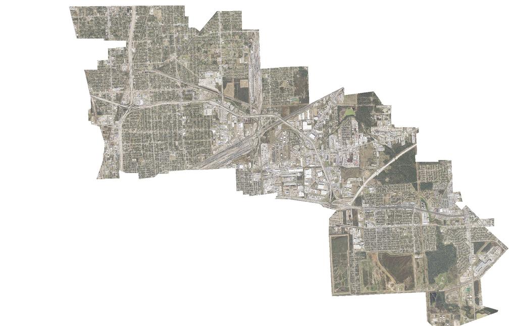
47
48
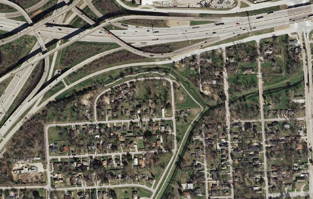
49

50
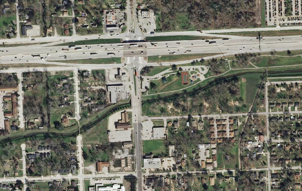
51
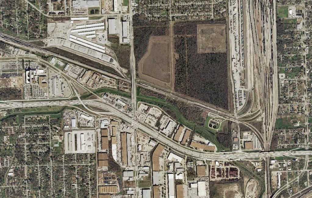
52
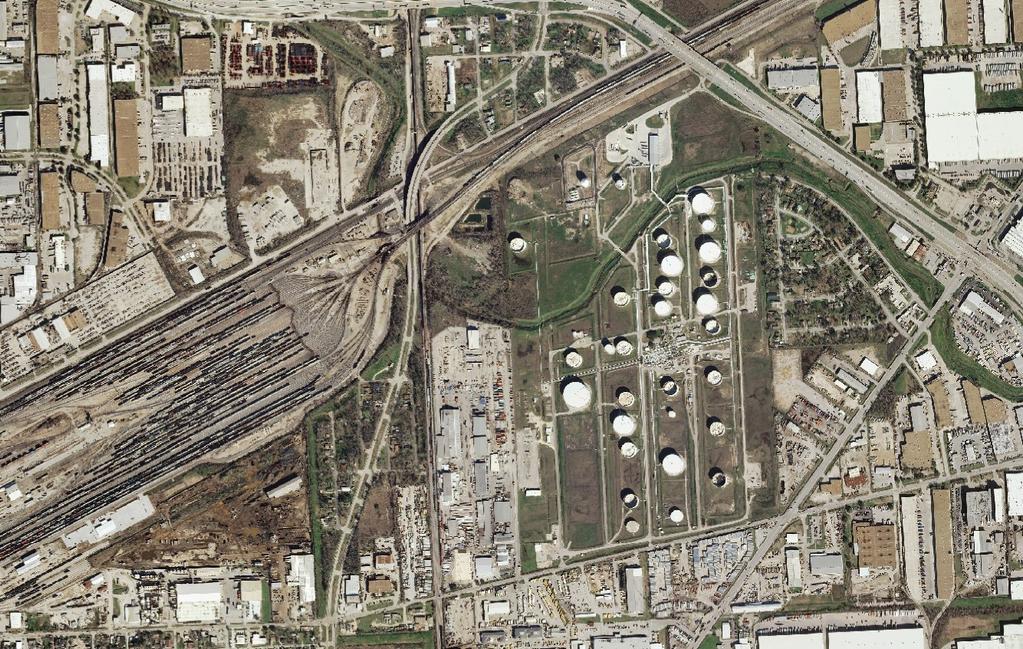
53
54
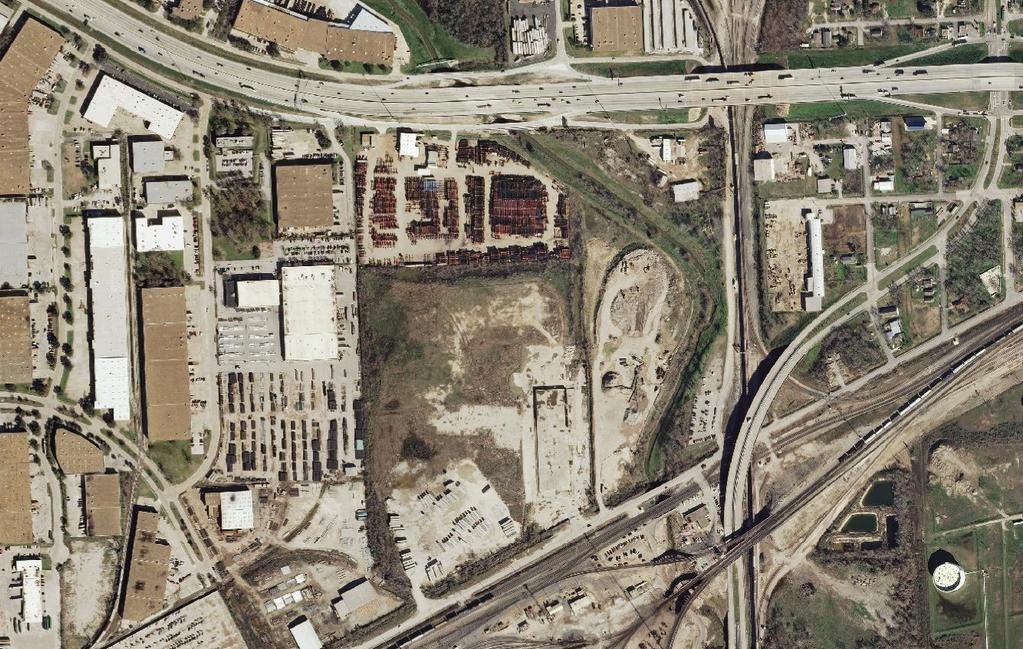
55
56

57
Appendix B Real Estate Plan
 Appendix B Real Estate Plan B-1 REAL ESTATE PLAN Prepared for U.S. Army Corps of Engineers Southwestern Division Little Rock District As of May 1, 2013 Prepared by Ronald Bridges Real Estate Division ANY
JANUARY 2016 MAMARONECK & SHELDRAKE RIVERS NEW YORK FLOOD RISK MANAGEMENT GENERAL REEVALUATION REPORT FOR THE VILLAGE OF MAMARONECK APPENDIX E
 U.S. Army Corps of Engineers New York District MAMARONECK & SHELDRAKE RIVERS NEW YORK FLOOD RISK MANAGEMENT GENERAL REEVALUATION REPORT FOR THE VILLAGE OF MAMARONECK JANUARY 2016 APPENDIX E REAL ESTATE
Appendix C. Real Estate. Brazos Island Harbor, Texas Channel Improvement Project Cameron County, Texas
 Appendix C Real Estate Brazos Island Harbor, Texas Channel Improvement Project Cameron County, Texas U.S. Army Corps of Engineers, Galveston District 2000 Fort Point Road Galveston, Texas 77550 December
Appendix G. Non-Federal Letters of Support and Draft Real Estate Plan
 Appendix G Non-Federal Letters of Support and Draft Real Estate Plan REAL ESTATE PLAN UPPER DELAWARE RIVER WATERSHED FEASABILITY STUDY LIVINGSTON MANOR, NEW YORK 1. GENERAL 2. REAL ESTATE REQUIREMENTS
Appendix B Draft Real Estate Plan
 Appendix B Draft Real Estate Plan B-1 REAL ESTATE PLAN Prepared for U.S. Army Corps of Engineers Southwestern Division Little Rock District As of December 3, 2012 Prepared by Ronald Bridges Real Estate
APPENDIX D - REAL ESTATE
 APPENDIX D - REAL ESTATE 1. Purpose Real Estate Plan For Feasibility Study For Lake Lou Yaeger Section 206 Aquatic Ecosystem Restoration Continuing Authorities Project Feasibility Study This report is
MAMARONECK AND SHELDRAKE RIVER FLOOD DAMAGE REDUCTION PROJECT MAMARONECK, NEW YORK APPENDIX E REAL ESTATE PLAN
 U.S. Army Corps of Engineers New York District MAMARONECK AND SHELDRAKE RIVER FLOOD DAMAGE REDUCTION PROJECT MAMARONECK, NEW YORK APPENDIX E REAL ESTATE PLAN April 2017 MAMARONECK AND SHELDRAKE RIVER FLOOD
Draft Continuing Authorities Program Section 1135 Detailed Project Report and Integrated Environmental Assessment
 Appendix G Real Estate Shorty s Island / Meander Reach Ecosystem Restoration Kootenai River, Idaho Draft Continuing Authorities Program Section 1135 Detailed Project Report and Integrated Environmental
DRAFT INTEGRATED FEASIBILITY REPORT AND ENVIRONMENTAL ASSESSMENT
 APPENDIX E REAL ESTATE PLAN MT. SINAI MEDICAL CENTER, CONTINUTING AUTHORITIES PROGRAM (CAP) SECTION 14, PROJECT DRAFT INTEGRATED FEASIBILITY REPORT AND ENVIRONMENTAL ASSESSMENT September 2016 DRAFT APPENDIX
WEST SHORE LAKE PONTCHARTRAIN HURRICANE AND STORM DAMAGE RISK REDUCTION STUDY INTEGRATED DRAFT FEASIBILITY REPORT AND ENVIRONMENTAL IMPACT STATEMENT
 WEST SHORE LAKE PONTCHARTRAIN HURRICANE AND STORM DAMAGE RISK REDUCTION STUDY INTEGRATED DRAFT FEASIBILITY REPORT AND ENVIRONMENTAL IMPACT STATEMENT REAL ESTATE PLAN APPENDIX C Annex A: Project Maps Annex
Draft Environmental Impact Statement (EIS)/Environmental Impact Report (EIR) APPENDIX H Real Estate Cost
/Environmental Impact Report (EIR) APPENDIX H Real Estate Cost") Draft Environmental Impact Statement (EIS)/Environmental Impact Report (EIR) APPENDIX H Real Estate Cost US Army Corps of Engineers Corte Madera Creek Flood Risk Management Project October 2018 APPENDIX
Draft Environmental Impact Statement (EIS)/Environmental Impact Report (EIR) APPENDIX H Real Estate Cost US Army Corps of Engineers Corte Madera Creek Flood Risk Management Project October 2018 APPENDIX
APPENDIX M. Real Estate Plan
 APPENDIX M Real Estate Plan Poplar Island Environmental Restoration Project September 2005 General Reevaluation Report (GRR) and Supplemental Environmental Impact Statement (SEIS) REAL ESTATE PLAN (REP)
EDISTO BEACH COASTAL STORM DAMAGE REDUCTION GENERAL INVESTIGATION STUDY APPENDIX K REAL ESTATE
 EDISTO BEACH COASTAL STORM DAMAGE REDUCTION GENERAL INVESTIGATION STUDY APPENDIX K REAL ESTATE Table of Contents REAL ESTATE APPENDIX... I... i SECTION 1. THE REAL ESTATE REPORT... 1 1.1 Statement of Purpose...
INDIANA HARBOR AND CANAL CONFINED DISPOSAL FACILITY EAST CHICAGO, INDIANA
 INDIANA HARBOR AND CANAL CONFINED DISPOSAL FACILITY EAST CHICAGO, INDIANA APPENDIX J REAL ESTATE Acquisition Branch Real Estate Division Chicago District U.S. Army Corps of Engineers APPENDIX J REAL ESTATE
HASHAMOMUCK COVE, SOUTHOLD, NEW YORK COASTAL STORM RISK MANAGEMENT FEASIBILITY STUDY APPENDIX F REAL ESTATE PLAN
 U.S. Army Corps of Engineers New York District HASHAMOMUCK COVE, SOUTHOLD, NEW YORK COASTAL STORM RISK MANAGEMENT FEASIBILITY STUDY APPENDIX F REAL ESTATE PLAN AUGUST 2016 HASHAMOMUCK COVE, SOUTHOLD, NEW
Delaware River Basin Comprehensive Flood Risk Management Interim Feasibility Study and Integrated Environmental Assessment for New Jersey
 Delaware River Basin Comprehensive Flood Risk Management Interim Feasibility Study and Integrated Environmental Assessment for New Jersey Flooding in the Study Area, April 2005 June 2015 APPENDIX F: Draft
Appendix H: Real Estate Plan
 APPENDIX H Spring Creek North Ecosystem Restoration Feasibility Study Appendix H: Real Estate Plan New York District U.S. Army Corps of Engineers October 2016 Revised: 13 April 2017 Spring Creek North
APPENDIX H REAL ESTATE PLAN
 APPENDIX H REAL ESTATE PLAN This page intentionally left blank. APPENDIX H REAL ESTATE PLAN DALLAS FLOODWAY FEASIBILITY STUDY DATE OF REPORT January 31, 2014 PREPARED BY REAL ESTATE DIVISION U.S. ARMY
Skagit River Flood Risk Management General Investigation Skagit County, Washington. Draft Feasibility Report and Environmental Impact Statement
 General Investigation Skagit County, Washington Draft Feasibility Report and Environmental Impact Statement May 2014 Real Estate Requirements of Selected Plan This Real Estate Plan Summary (REP) is presented
APPENDIX F REAL ESTATE
 APPENDIX F REAL ESTATE Real Estate Plan For Broward County, Florida Shore Protection Project Segments II and III General Reevaluation Report 1. Statement Of Purpose. The Real Estate Plan is tentative in
REAL ESTATE PLAN APPENDIX G
 Pacific Ocean Division REAL ESTATE PLAN APPENDIX G Alaska District UNALASKA (DUTCH HARBOR) CHANNELS UNALASKA, ALASKA Real Estate Division Alaska District U.S. Army Corps of Engineers TABLE OF CONTENTS
Draft Appendix E. Real Estate Plan. Rahway River Basin, New Jersey Flood Risk Management Feasibility Study. November 2016
 Draft Appendix E Real Estate Plan Rahway River Basin, New Jersey Flood Risk Management Feasibility Study November 2016 New Jersey Department of Environmental Protection U.S. Army Corps of Engineers New
Draft Integrated Feasibility Report and Environmental Assessment and Draft Finding of No Significant Impact
 Draft Integrated Feasibility Report and Environmental Assessment and Draft Finding of No Significant Impact APPENDIX F: REAL ESTATE Whittier, Alaska June 2018 Pacific Ocean Division DRAFT REAL ESTATE
APPENDIX C REAL ESTATE PLAN BOULEVARD RESACA, BROWNSVILLE, TX CAMERON COUNTY, TEXAS
 APPENDIX C REAL ESTATE PLAN BOULEVARD RESACA, BROWNSVILLE, TX CAMERON COUNTY, TEXAS November 19, 2016 Table of Contents Purpose... 3 Project Authority... 3 Project Location and Description... 3 Non-Federal
APPENDIX H REAL ESTATE REQUIREMENTS
 Malden River Ecosystem Restoration Detailed Project Report APPENDIX H REAL ESTATE REQUIREMENTS April 2007 Malden River Ecosystem Restoration Real Estate Report 1. PURPOSE: The Detailed Project Report
APPENDIX E REAL ESTATE PLAN
 APPENDIX E REAL ESTATE PLAN REAL ESTATE PLAN VILLAGE OF BARBOURSVILLE, WATER STREET, STREAMBANK PROTECTION PROJECT CABELL COUNTY, WEST VIRGINIA SECTION 14 1. Authority/Purpose This Real Estate Plan is
Land Management Plan Fargo-Moorhead (FM) Area Flood Risk Reduction Project Version 1
 Area Flood Risk Reduction Project Version 1") Land Management Plan Fargo-Moorhead (FM) Area Flood Risk Reduction Project Version 1 Prepared for Fargo-Moorhead Area Flood Diversion Board of Authority July 12, 2012 REV 1 Contents Section Page Acronyms
Land Management Plan Fargo-Moorhead (FM) Area Flood Risk Reduction Project Version 1 Prepared for Fargo-Moorhead Area Flood Diversion Board of Authority July 12, 2012 REV 1 Contents Section Page Acronyms
DRAFT REAL ESTATE PLAN APPENDIX D JEFFERSON COUNTY ECOSYSTEM RESTORATION FEASIBILITY STUDY
 DRAFT REAL ESTATE PLAN APPENDIX D JEFFERSON COUNTY ECOSYSTEM RESTORATION FEASIBILITY STUDY (NOTE: This page intentionally left blank.) This Real Estate Plan has been prepared in accordance with ER 405-1-12
UPPER MISSISSIPPI RIVER RESTORATION FEASIBILITY REPORT WITH INTEGRATED ENVIRONMENTAL ASSESSMENT
 UPPER MISSISSIPPI RIVER RESTORATION FEASIBILITY REPORT WITH INTEGRATED ENVIRONMENTAL ASSESSMENT McGregor Lake HABITAT REHABILITATION AND ENHANCEMENT PROJECT POOL 10, UPPER MISSISSIPPI RIVER MILE 635-634
APPENDIX G REAL ESTATE
 BUBBLY CREEK, SOUTH BRANCH OF THE CHICAGO RIVER, ILLINOIS FEASIBILITY STUDY APPENDIX G REAL ESTATE DRAFT - NOT FOR DISTRIBUTION APRIL 2015 U.S. Army Corps of Engineers Chicago District Appendix G Real
APPENDIX D REAL ESTATE PLAN
 APPENDIX D REAL ESTATE PLAN APPENDIX D REAL ESTATE PLAN TABLE OF CONTENTS 1. STATEMENT OF PURPOSE 2. REFERENCES 3. AUTHORIZATION 4. BACKGROUND 5. LOCATION 6. REAL ESTATE REQUIREMENTS 7. OWNERSHIP OF REAL
DRAFT East Rockaway Inlet to Rockaway Inlet and Jamaica Bay. Atlantic Coast of New York
 DRAFT East Rockaway Inlet to Rockaway Inlet and Jamaica Bay Atlantic Coast of New York APPENDIX E REAL ESTATE PLAN AUGUST 2018 East Rockaway Inlet to Rockaway Inlet and Jamaica Bay Reformulation Study
REAL ESTATE PLAN. Final Integrated General Reevaluation Report and Supplemental Environmental Impact Statement
 REAL ESTATE PLAN Final Integrated General Reevaluation Report and Supplemental Environmental Impact Statement Mississippi River, Baton Rouge to the Gulf of Mexico Mississippi River-Gulf Outlet, Louisiana,
APPENDIX H. Real Estate Plan
 INTEGRATED FEASIBILITY REPORT AND ENVIRONMENTAL IMPACT STATEMENT COASTAL STORM DAMAGE REDUCTION BOGUE BANKS, CARTERET COUNTY NORTH CAROLINA APPENDIX H Real Estate Plan US Army Corps of Engineers Wilmington
APPENDIX D REAL ESTATE DRAFT. MOBILE HARBOR, MOBILE, ALABAMA Integrated General Reevaluation Report With Supplemental Environmental Impact Statement
 APPENDIX D REAL ESTATE DRAFT MOBILE HARBOR, MOBILE, ALABAMA Integrated General Reevaluation Report With Supplemental Environmental Impact Statement Table of Contents 1. Purpose of the Real Estate Plan
Mississippi River Ship Channel Gulf to Baton Rouge, LA Integrated General Reevaluation Report And Supplemental Environmental Impact Statement
 APPENDIX B Real Estate Plan B-1.0 PROJECT PURPOSE, DESCRIPTION, LOCATION AND DESCRIPTION OF THE LANDS, EASEMENTS, RIGHTS-OF-WAY, RELOCATIONS AND DISPOSAL (LERRD) REQUIRED The purpose of this Real Estate
AGREEMENT TO ACQUIRE LANDS BETWEEN THE DEPARTMENT OF THE ARMY ST. PAUL DISTRICT, CORPS OF ENGINEERS AND. THE CITY OF City, State
 AGREEMENT TO ACQUIRE LANDS BETWEEN THE DEPARTMENT OF THE ARMY ST. PAUL DISTRICT, CORPS OF ENGINEERS AND THE CITY OF City, State FOR CONDEMNATION ON BEHALF OF THE SPONSOR BY THE CORPS OF ENGINEERS FOR THE
DRAFT REAL ESTATE PLAN APPENDIX C GULF INTRACOASTAL WATERWAY BRAZOS RIVER FLOODGATES AND COLORADO RIVER LOCKS SYSTEMS FEASIBILITY STUDY
 DRAFT REAL ESTATE PLAN APPENDIX C GULF INTRACOASTAL WATERWAY BRAZOS RIVER FLOODGATES AND COLORADO RIVER LOCKS SYSTEMS FEASIBILITY STUDY This Real Estate Plan has been prepared in accordance with ER 405-1-12
Appendix J. Real Estate Plan
 Appendix J Real Estate Plan Real Estate Plan Louisiana Coastal Area Near-Term Ecosystem Restoration Plan Medium Diversion at White Ditch 1. PURPOSE Title VII of the Water Resources Development Act of 2007
Chapter 5. Floodplain Management. 5.0 Introduction. 5.1 Floodplain Management and Regulation
 5.0 Introduction This chapter summarizes the Town s rules and regulations regarding floodplain management and development. The requirements presented in this chapter should be used by the design engineer
GENERAL RE-EVALUATION REPORT APPENDIX B: REAL ESTATE SAVANNAH HARBOR EXPANSION PROJECT Chatham County, Georgia and Jasper County, South Carolina
 GENERAL RE-EVALUATION REPORT APPENDIX B: REAL ESTATE SAVANNAH HARBOR EXPANSION PROJECT Chatham County, Georgia and Jasper County, South Carolina January 2012 (Revised July 2012) US Army Corps of Engineers
Dredged Material Management Plan Atlantic Intracoastal Waterway Port Royal Sound, South Carolina to Cumberland Sound, Georgia November 2015
 Dredged Material Management Plan Atlantic Intracoastal Waterway Port Royal Sound, South Carolina to Cumberland Sound, Georgia November 2015 Appendix H: Real Estate US Army Corps of Engineers South Atlantic
Appendix D Real Estate Plan
 Appendix D Real Estate Plan Matagorda Ship Channel, Port Lavaca, Texas Feasibility Report and Environmental Impact Statement, Review of Completed Projects, Calhoun and Matagorda Counties May 2018 (NOTE:
Appendix K. Real Estate Plan
 Appendix K. Real Estate Plan REAL ESTATE PLAN DELTA ISLANDS AND LEVEES FEASIBILITY STUDY (DELTA STUDY) 20 June 2018 PREPARED BY THE SACRAMENTO DISTRICT U.S. ARMY CORPS OF ENGINEERS 1 TABLE OF CONTENTS
Chapter 5. Floodplain Management. 5.0 Introduction. 5.1 Douglas County Comprehensive Master Plan. 5.2 Floodplain Management and Regulation
 5.0 Introduction This chapter summarizes the County s rules and regulations regarding floodplain management and development. The requirements presented in this chapter should be used by the design engineer
CITY OF FORT COLLINS NATURAL AREAS AND CONSERVED LANDS EASEMENT POLICY
 CITY OF FORT COLLINS NATURAL AREAS AND CONSERVED LANDS EASEMENT POLICY Adopted January 3, 2012 PURPOSE: The purpose of the policy statement is to clarify the policies and procedures of the City of Fort
Real Estate Plan Beaver Lake Water Supply Reallocation White River Rogers, Arkansas. 20 April 2017
 Real Estate Plan Beaver Lake Water Supply Reallocation White River Rogers, Arkansas 20 April 2017 Prepared For US Army Corps of Engineers Southwestern Division Little Rock District Prepared By Jeremy R.
Appendix D: Real Estate
 Shrewsbury River Basin, Sea Bright, New Jersey Coastal Storm Risk Management Feasibility Study Draft Integrated Feasibility Report & Environmental Assessment Appendix D: Real Estate Shrewsbury River Basin,
CHECKLIST FOR DEVELOPMENT REVIEW
 CHECKLIST FOR DEVELOPMENT REVIEW Petitions and related documents and plans for land development or other proposals regulated by Title 16 of the Municipal Code (Development Ordinance) and Title 17 of the
Town of Surf City. City Council Presentation April 2, 2013 PETER A. RAVELLA, PRINCIPAL PAR CONSULTING, LLC
 Town of Surf City City Council Presentation April 2, 2013 PETER A. RAVELLA, PRINCIPAL CONSULTING, LLC I. Review Workshop schedule & Input SC-NTB Federal Project Plan 1550 Funding Contributors You re Not
Downtown Montauk Stabilization Project. Real Estate Plan Appendix
 Downtown Montauk Stabilization Project Real Estate Plan Appendix October 2014 Table of Contents Page 1. Introduction and General Information 1 a. Authority 2 b. History 2 c. Location Project Study Area
DEPARTMENT OF THE ARMY OFFICE OF THE CHIEF OF ENGINEERS WASHINGTON, D.C
 DEPARTMENT OF THE ARMY OFFICE OF THE CHIEF OF ENGINEERS WASHINGTON, D.C. 20314-1000 REPLY TO ATTENTION OF: CECW-PM (10-1-7a) THE SECRETARY OF THE ARMY 1. I submit for transmission to Congress my report
Southwest Coastal Louisiana Study
 REAL ESTATE PLAN Annex 1: Project Maps Annex 2: Assessment of Non-Federal Sponsor s Acquisition Capability Annex 3: Non-Material Deviation from Standard Estate Perpetual Access Easement Annex 4: Baseline
Appendix J - Planned Unit Development (PUD)
") Appendix J - Planned Unit Development (PUD) Intent and Purpose The purpose of the PUD is: 1. To provide development that is consistent with the Comprehensive Land Use Plan and promote the goals and objectives
Appendix J - Planned Unit Development (PUD) Intent and Purpose The purpose of the PUD is: 1. To provide development that is consistent with the Comprehensive Land Use Plan and promote the goals and objectives
APPENDIX D REAL ESTATE
 APPENDIX D REAL ESTATE American River Watershed Common Features General Reevaluation Report Real Estate Plan February 2015 1 Cover Photos courtesy of the Sacramento District: Sacramento Weir during operation
Town of Alexandria. Floodplain Management Ordinance
 1 of 7 8/8/2009 4:56 PM Town of Alexandria Floodplain Management Ordinance SECTION 1 PURPOSE Certain areas of the Town of Alexandria, New Hampshire are subject to periodic flooding, causing serious damages
CENAN-RE 22 May MEMORANDUM FOR Chief, Planning Division, ATTN: CENAN-PL-F (Alek Petersen)
") CENAN-RE 22 May 2017 MEMORANDUM FOR Chief, Planning Division, ATTN: CENAN-PL-F (Alek Petersen) SUBJECT: May 2017 Real Estate Plan for the Rahway River (Tidal) Basin, Coastal Storm Risk Management Feasibility
CENAN-RE 22 May 2017 MEMORANDUM FOR Chief, Planning Division, ATTN: CENAN-PL-F (Alek Petersen) SUBJECT: May 2017 Real Estate Plan for the Rahway River (Tidal) Basin, Coastal Storm Risk Management Feasibility
RULES AND REGULATIONS FOR ADMINISTRATION OF AREA DRAINAGE PLANS
 RIVERSIDE COUNTY RULES AND REGULATIONS FOR ADMINISTRATION OF AREA DRAINAGE PLANS ADOPTED JUNE 10, 1980 BY RESOLUTION NO. 80-244 AMENDMENTS RESOLUTION NO. May 26, 1981 81-148 Nov. 9, 1982 82-320 July 3,
APPLICATION PROCEDURE
 ANTRIM PLANNING BOARD P. O. Box 517 Antrim, New Hampshire 03440 Phone: 603-588-6785 FAX: 603-588-2969 APPLICATION FORM AND CHECKLIST FOR MINOR OR MAJOR SITE PLAN REVIEW File Date Received By APPLICATION
The Drainage Control Regulations
 1 The Drainage Control Regulations Repealed by Saskatchewan Regulations 89/2015 (effective October 16, 2015) Formerly Chapter D-33.1 Reg 1 (effective August 18, 1981) as amended by Saskatchewan Regulations
APPENDIX F REAL ESTATE PLAN. Redwood City Harbor Navigation Improvement Feasibility Study, Redwood City, California
 APPENDIX F REAL ESTATE PLAN Redwood City Harbor Navigation Improvement Feasibility Study, Redwood City, California PREPARED FOR THE SAN FRANCISCO DISTRICT SOUTH PACIFIC DIVISION 20 April 2015 PREPARED
DIVISION 2 - CONSTRUCTION PLAN AND MISCELLANEOUS REQUIREMENTS
 DIVISION 2 - CONSTRUCTION PLAN AND MISCELLANEOUS REQUIREMENTS 2.1 Required Plan Sheets 2.2 Drawing Requirements 2.3 Graphic Standards 2.4 Easements 2.5 Utility Locations 2.6 Private Facility Locations
Public Notice U.S. ARMY CORPS OF ENGINEERS, GALVESTON DISTRICT AND TEXAS COMMISSION ON ENVIRONMENTAL QUALITY
 Public Notice U.S. Army Corps Permit Application No: SWG-2016-00384 Of Engineers Date Issued: 27 December 2018 Galveston District Comments Due: 29 January 2019 U.S. ARMY CORPS OF ENGINEERS, GALVESTON DISTRICT
DEPARTMENT OF THE ARMY OFFICE OF THE CHIEF OF ENGINEERS WASHINGTON. D.C MAR
 DEPARTMENT OF THE ARMY OFFICE OF THE CHIEF OF ENGINEERS WASHINGTON. D.C. 2031 4-1 000 MAR 3 1 2006 CEMP-NAD (1 0-1-7a) THE SECRETARY OF THE ARMY 1. I submit for transmission to Congress my report on the
BACKGROUND There are 23 flood control structures in the Upper Brushy Creek Water Control and Improvement District (District). See attached map.
. See attached map.") BACKGROUND There are 23 flood control structures in the Upper Brushy Creek Water Control and Improvement District (District). See attached map. The U.S Department of Agriculture - Natural Resources Conservation
BACKGROUND There are 23 flood control structures in the Upper Brushy Creek Water Control and Improvement District (District). See attached map. The U.S Department of Agriculture - Natural Resources Conservation
UPPER MISSISSIPPI RIVER RESTORATION FEASIBILITY REPORT WITH INTEGRATED ENVIRONMENTAL ASSESSMENT
 UPPER MISSISSIPPI RIVER RESTORATION FEASIBILITY REPORT WITH INTEGRATED ENVIRONMENTAL ASSESSMENT BEAVER ISLAND HABITAT REHABILITATION AND ENHANCEMENT PROJECT POOL 14, UPPER MISSISSIPPI RIVER MILES 513.0-517.0
FIRE ISLAND INLET TO MORICHES INLET FIRE ISLAND STABILIZATION PROJECT TECHNICAL SUPPORT DOCUMENT
 FIRE ISLAND INLET TO MORICHES INLET FIRE ISLAND STABILIZATION PROJECT TECHNICAL SUPPORT DOCUMENT EVALUATION OF A STABILIZATION PLAN FOR STORM DAMAGE REDUCTION COST APPENDIX U.S. Army Corps of Engineers
SECTION 10: FLOOD HAZARD EVALUATION 10-1
 10) SECTION 10: FLOOD HAZARD EVALUATION A. General. Land subject to being flooded by a Flood of 100-Year Frequency as defined by Title 76, Chapter 5, MCA, or land subject to flooding pursuant to these
VI. SAFETY ELEMENT I. INTRODUCTION A. PURPOSE B. AUTHORITY. 1. Safety
 AB 162 and SB 1241 Amendment to the Safety Element New sections are underlined, deleted sections are shown as strikethrough and the denotes text remaining in place. VI. SAFETY ELEMENT I. INTRODUCTION A.
BRISTOL CONSERVATION COMMISSION INLAND WETLANDS AGENCY FORM IW-1 (Application for a Wetlands Permit)
") APPLICATION NO. BRISTOL CONSERVATION COMMISSION INLAND WETLANDS AGENCY FORM IW-1 (Application for a Wetlands Permit) DATE FILED: APPROVED: DENIED: 1. APPLICANT: Name: Signature: Address: City: State: Zip
APPLICATION NO. BRISTOL CONSERVATION COMMISSION INLAND WETLANDS AGENCY FORM IW-1 (Application for a Wetlands Permit) DATE FILED: APPROVED: DENIED: 1. APPLICANT: Name: Signature: Address: City: State: Zip
Preliminary Subdivision Application (Minor) (Three (3) lots or less)
 (Three (3) lots or less)") Gunnison City Offices www.gunnisoncity.org 38 West Center Gunnison, Utah 84634 (435) 528 7969 Date of Application: Preliminary Subdivision Application (Minor) (Three (3) lots or less) APPLICANT INFORMATION
Gunnison City Offices www.gunnisoncity.org 38 West Center Gunnison, Utah 84634 (435) 528 7969 Date of Application: Preliminary Subdivision Application (Minor) (Three (3) lots or less) APPLICANT INFORMATION
Floodplain Development Land Use Review
 PUBLIC WORKS - COMMUNITY DEVELOPMENT 333 Broadalbin Street SW, PO Box 490, Albany, Oregon 97321-0144 BUILDING 541-917-7553 PLANNING 541-917-7550 Floodplain Development Land Use Review Application Information
ARTICLE 5 MINOR SUBDIVISION/LAND DEVELOPMENT
 ARTICLE 5 MINOR SUBDIVISION/LAND DEVELOPMENT SECTION 501 ONLY FINAL PLAN REQUIRED The classification of a proposed subdivision as a "Minor Subdivision" shall only require the submission, review and approval
9. REZONING NO Vicinity of the northwest corner of 143 rd Street and Metcalf Avenue
 9. REZONING NO. 2002-15 Vicinity of the northwest corner of 143 rd Street and Metcalf Avenue 1. APPLICANT: Andrew Schlagel is the applicant for this request. 2. REQUESTED ACTION: The applicant is requesting
Preliminary Subdivision Application (Major) (Four (4) lots or more)
 (Four (4) lots or more)") Gunnison City Offices www.gunnisoncity.org 38 West Center Gunnison, Utah 84634 (435) 528 7969 Date of Application: Preliminary Subdivision Application (Major) (Four (4) lots or more) APPLICANT INFORMATION
Gunnison City Offices www.gunnisoncity.org 38 West Center Gunnison, Utah 84634 (435) 528 7969 Date of Application: Preliminary Subdivision Application (Major) (Four (4) lots or more) APPLICANT INFORMATION
Applicant: Address: Fee Owner: Address: Property Location (Address and Complete (long) Legal Description: Detailed Reason for Request:
 Legal Description: Detailed Reason for Request:") Date Received: Received By: Permit #: LAND USE APPLICATION Comprehensive Plan Zoning District Amend Zoning Text Amend Variance*(see below) Zoning Appeal Conditional Use Permit (C.U.P.) Flood Plain C.U.P.
Date Received: Received By: Permit #: LAND USE APPLICATION Comprehensive Plan Zoning District Amend Zoning Text Amend Variance*(see below) Zoning Appeal Conditional Use Permit (C.U.P.) Flood Plain C.U.P.
DESCRIPTION OF THE DISTRICT
 DESCRIPTION OF THE DISTRICT The project plan for City of Wausau, Tax Increment District #11 has been prepared in compliance with Wisconsin Statutes Chapter 66.1105(4). The plan establishes the need for
CITY OF GROVER BEACH COMMUNITY DEVELOPMENT DEPARTMENT Tentative Map Checklist
 CITY OF GROVER BEACH COMMUNITY DEVELOPMENT DEPARTMENT Tentative Map Checklist The following list includes all of the items you must submit for a complete application. Some specific types of information
MIDDLE RIO GRANDE FLOOD PROTECTION, BERNALILLO TO BELEN, NM PROJECT BERNALILLO AND VALENCIA COUNTIES, NEW MEXICO. Appendix I Real Estate Plan
 MIDDLE RIO GRANDE FLOOD PROTECTION, BERNALILLO TO BELEN, NM PROJECT BERNALILLO AND VALENCIA COUNTIES, NEW MEXICO Appendix I Real Estate Plan LOS ANGELES DISTRICT ASSET MANAGEMENT US Army Corps Of Engineers
APPLICATION REVIEW CHECKLISTS
 APPLICATION REVIEW CHECKLISTS The following must be submitted with and are part of each application. No application is complete until all required documentation has been submitted to the Community Development
MAJOR SUBDIVISION PRELIMINARY PLAT CHECKLIST
 TOWNSHIP OF EGG HARBOR PLANNING BOARD/ZONING BOARD OF ADJUSTMENT 3515 BARGAINTOWN ROAD EGG HARBOR TOWNSHIP, NJ 08234 MAJOR SUBDIVISION PRELIMINARY PLAT CHECKLIST The following checklist is designed to
TOWNSHIP OF EGG HARBOR ZONING BOARD ADJUSTMENT CHECK LIST
 TOWNSHIP OF EGG HARBOR ZONING BOARD ADJUSTMENT CHECK LIST Schedule A - General Requirements 1. Where the application involves only a variance one (1) original and nineteen (19) copies of the appropriate
RULES, REGULATIONS AND REQUIREMENTS RELATING TO THE APPROVAL AND ACCEPTANCE OF IMPROVEMENTS IN SUBDIVISIONS OR RE-SUBDIVISIONS
 GALVESTON COUNTY RULES, REGULATIONS AND REQUIREMENTS RELATING TO THE APPROVAL AND ACCEPTANCE OF IMPROVEMENTS IN SUBDIVISIONS OR RE-SUBDIVISIONS GALVESTON COUNTY ENGINEERING DEPARTMENT MARCH 3, 1997 Amendment
APPLICATION FOR 555 Washington Street Tentative Map Red Bluff, CA Subdivision Map (530) ext Parcel Map.
 ext Parcel Map.") City of Red Bluff Community Development Department Application No. APPLICATION FOR 555 Washington Street Tentative Map Red Bluff, CA 96080 Subdivision Map (530) 527-2605 ext. 3059 Parcel Map Applicant
City of Red Bluff Community Development Department Application No. APPLICATION FOR 555 Washington Street Tentative Map Red Bluff, CA 96080 Subdivision Map (530) 527-2605 ext. 3059 Parcel Map Applicant
DEPARTMENT OF THE ARMY U.S. Army Corps of Engineers Washington, DC Regulation No May 2015
 CEMP-CR DEPARTMENT OF THE ARMY U.S. Army Corps of Engineers Washington, DC 20314-1000 ER 405-1-19 Regulation No. 405-1-19 29 May 2015 Real Estate ACQUISITION BY CONDEMNATION PROCEEDINGS 1. Purpose. Engineer
PRELMINARY PLAT CHECKLIST
 PRELMINARY PLAT CHECKLIST A. All preliminary plat submitted for approval shall be prepared by a Registered Professional Land Surveyor. B. Preliminary plats must be drawn to a scale of XXX with such accuracy
ARTICLE 23 CONDOMINIUM STANDARDS
 ARTICLE 23 CONDOMINIUM STANDARDS Section 23.01 Intent. The intent of this Article is to provide regulatory standards for condominiums and site condominiums similar to those required for projects developed
Robert Street Gateway, West St. Paul, Minnesota. A Premier Development Opportunity at the Gateway to West St. Paul and Dakota County
 Robert Street Gateway, West St. Paul, Minnesota A Premier Development Opportunity at the Gateway to West St. Paul and Dakota County Robert Street Gateway, West St. Paul, Minnesota A Premier Development
PRELIMINARY PLAT CHECK LIST
 PRELIMINARY PLAT CHECK LIST Name of Proposed Subdivision: The following items must be included with the initial submittal of a Preliminary Plat: Application, filled out completely Project Narrative Pre-application
ZONING AMENDMENT, SUBDIVISION & SIDEWALK WAIVER REQUEST STAFF REPORT Date: November 16, 2006
 ZONING AMENDMENT, SUBDIVISION & SIDEWALK WAIVER REQUEST STAFF REPORT Date: November 16, 2006 NAME SUBDIVISION NAME Terhaar & Cronley Investment Partnership P & E Subdivision LOCATION 4210 and 4218 Halls
Corte Madera Marsh Restoration Project Update
 Corte Madera Marsh Restoration Project Update Building and Operating Committee Agenda Item No. 5 August 25, 2016 Photo credit: WRA Background of Site 1. 72 acre parcel carved out of larger property acquired
Memorandum To: From: CC: Date: Re:
 Memorandum To: Paul Singer From: Craig M. Bonenberger, SEO/ Jason P. Shaner, PE CC: File 090026 Date: 4/20/2009 Re: 1550 Pottstown Pike Feasibility Study The site under investigation is an 18 acre tract
Chapter 100 Planned Unit Development in Corvallis Urban Fringe
 100.100 Scope and Purpose. Chapter 100 Planned Unit Development in Corvallis Urban Fringe (1) All applications for land divisions in the Urban Residential (UR) and Flood Plain Agriculture (FPA) zones within
BYRON TOWNSHIP ZONING APPLICATION
 BYRON TOWNSHIP ZONING APPLICATION Phone: (616) 878-9104 * Fax: (616) 878-3980 * Website: www.byrontownship.org This application will not be accepted if incomplete. APPLICATION FOR & REQUIRED COPIES Private
-MENDOCINO COUNTY PLANNING AND BUILDING SERVICES- DIVISION OF LAND REGULATIONS TITLE 17
 ARTICLE VI -- GENERAL REGULATIONS AND PROVISIONS Sec. 17-50. Sec. 17-51 General Plan. Sec. 17-52 Lot and Block Design and Configuration. Sec. 17-53 Lot Access. Sec. 17-54 Private Roads. Sec. 17-55 Water
Emergency Watershed Program Sandy Recovery Activities and Flood Plain Easement Program
 Emergency Watershed Program Sandy Recovery Activities and Flood Plain Easement Program Greg Westfall, Resource Conservationist USDA-Natural Resources Conservation Service (NRCS) Set up by Congress to respond
GENERAL POLICIES GOVERNING LAND USE AND CITY LAND SALES IN WAUSAU WEST BUSINESS AND INDUSTRIAL PARK
 GENERAL POLICIES GOVERNING LAND USE AND CITY LAND SALES IN WAUSAU WEST BUSINESS AND INDUSTRIAL PARK Introduction: Wausau West Business and Industrial Park is recognized as an important asset to the City
Green and Barren Lock and Dam Disposition Study Louisville District, US Army Corps of Engineers February Appendix F: Real Estate Interests
 Green and Barren Lock and Dam Louisville District, US Army Corps of Engineers February 2014 Appendix F: Real Estate Interests Appendix F. Real Estate 1.0 General In 1991, the USACE conducted a study to
Special Use Permit - Planned Unit Development Checklist. Property Address:
 Special Use Permit - Planned Unit Development Checklist Special Use Permit Number. Parcel Code/s #28-11- - - Property Address: Applicant: ARTICLE VIII Ordinance Reference - Section 8.1.2 Permit Procedures:
SUBDIVISION APPLICATION CHECKLIST SKETCH PLAN PRELIMINARY PLAT FINAL PLAT
 RECEIVED STAMP SUBDIVISION APPLICATION CHECKLIST SKETCH PLAN PRELIMINARY PLAT FINAL PLAT A checklist of background information and submission requirements for processing of a sketch plan, preliminary plat